Geological Formation Mechanism and Thermal Resources Assessment of Geothermal Spring in Lushan County, China


Abstract
:1. Introduction
2. Materials and Methods
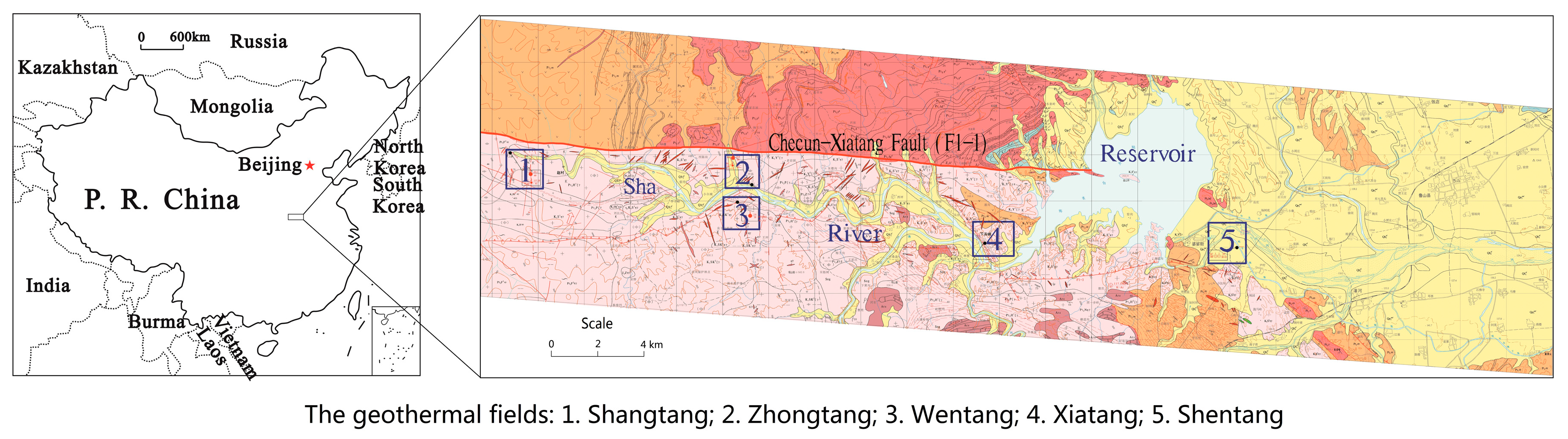
2.1. Geological Background of Research Area
2.2. Methods
2.2.1. Geological Interpretation of Remote Sensing
2.2.2. Field Geological Survey
2.2.3. Geophysical Exploration
- (a)
- IP Sounding (Induced Polarization Sounding Method)
- (b)
- EH-4 Magnetotelluric Sounding
- (c)
- Multi-Electrode Resistivity Method
2.2.4. Geological Drilling
2.2.5. Pumping Test
2.2.6. Long-Term Observation
2.2.7. Hydrochemistry Test of Water
3. Results and Analysis
3.1. Geothermal Characteristics of Lushan Geothermal Springs
3.1.1. Geothermal Type and Geothermal Reservoir Structure
3.1.2. Chemical Characteristics of Geothermal Water
3.1.3. Geothermal Water Temperature
3.1.4. Recharge, Runoff, and Discharge of Geothermal Water
3.2. Geological Characteristics of Lushan Geothermal Springs
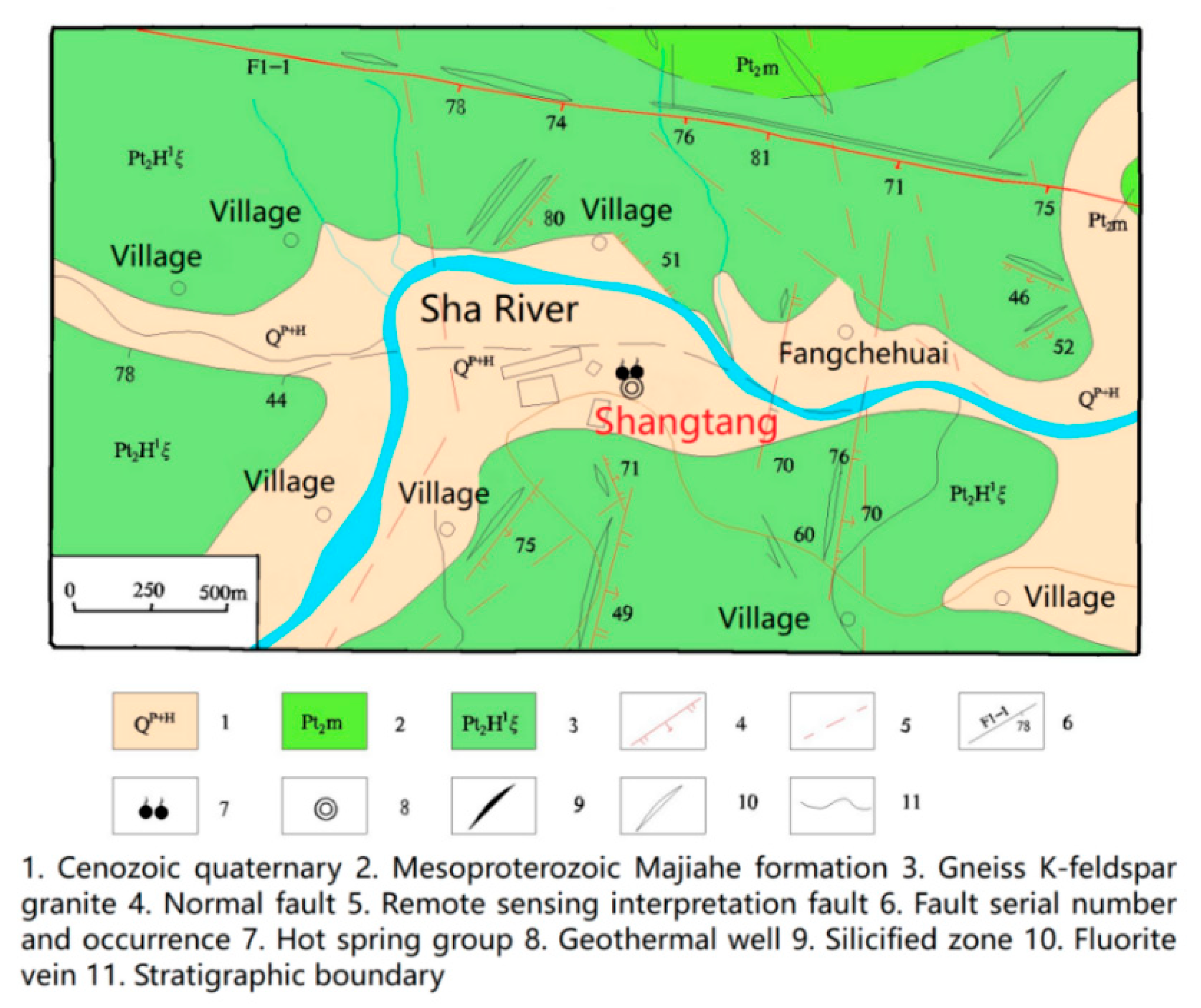
3.2.1. Geological Characteristics of Shangtang Geothermal Field
- (a)
- General Situation of Shangtang Hotspring
- (b)
- Combined Pumping Test
- (c)
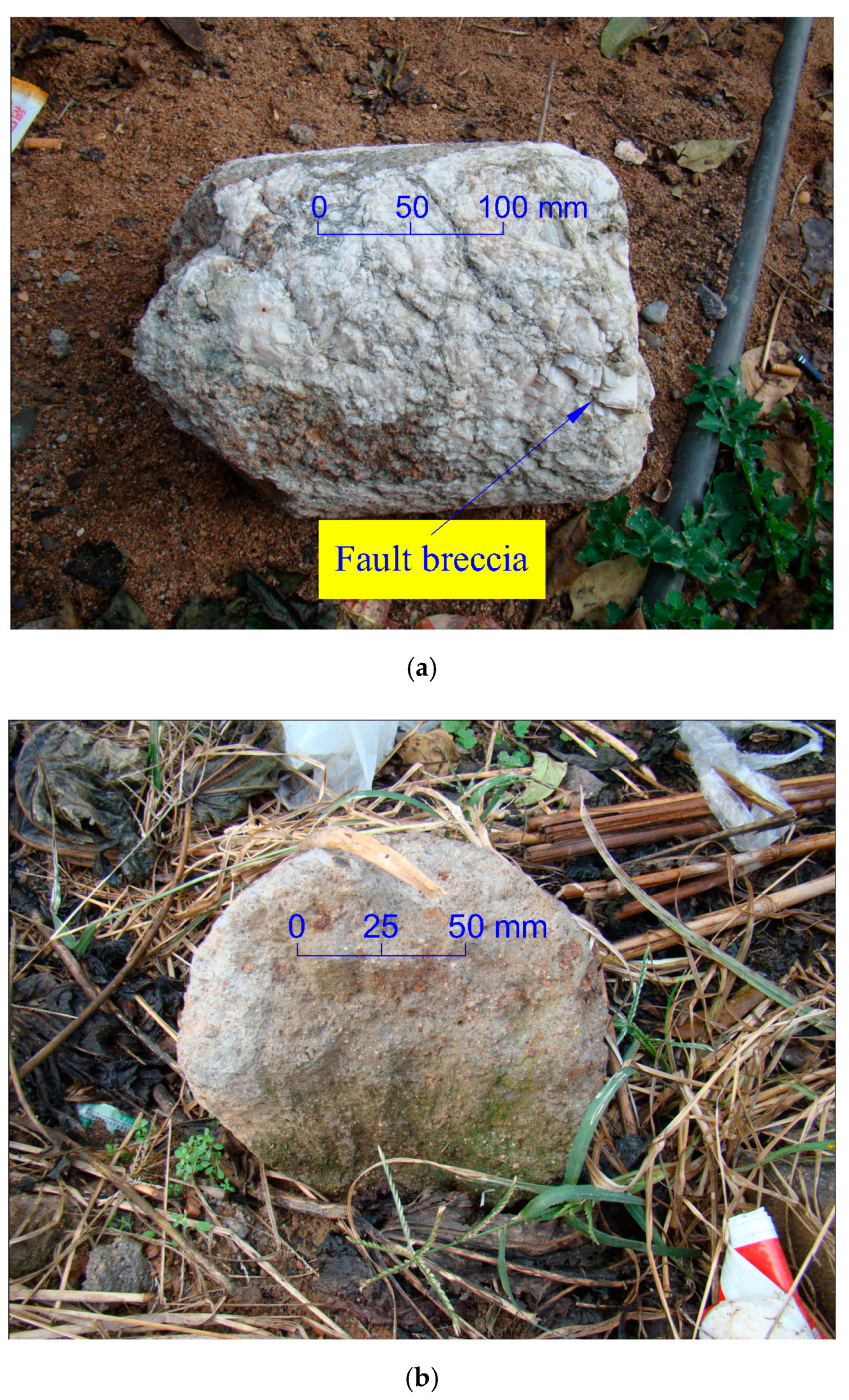
- Geological Structure Characteristics
- (d)
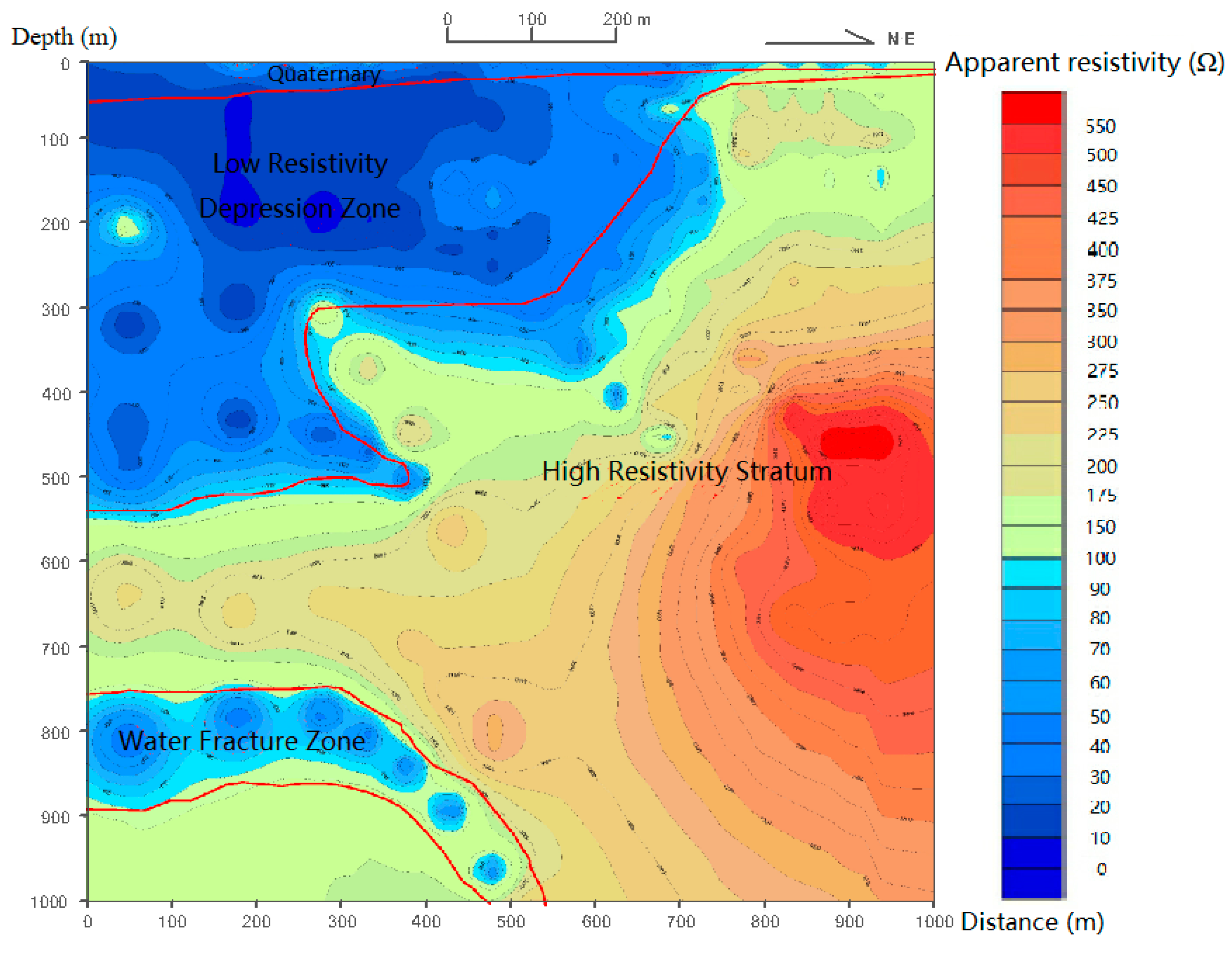
- Geophysical Characteristics of Shangtang Filed
3.2.2. Geological Characteristics of Zhongtang and Wentang Geothermal Field
- (a)
- General Situation of Zhongtang and Wentang Hotsprings
- (b)
- Geological Structure Characteristics of Zhongtang and Wentang Hotsprings
- (c)
- Geophysical Characteristics of Zhongtang and Wentang Filed
3.2.3. Geological Characteristics of Xiatang Geothermal Field
- (a)
- General Situation of Xiatang Hotspring
- (b)
- Geological Structure Characteristics of Xiatang Hotspring
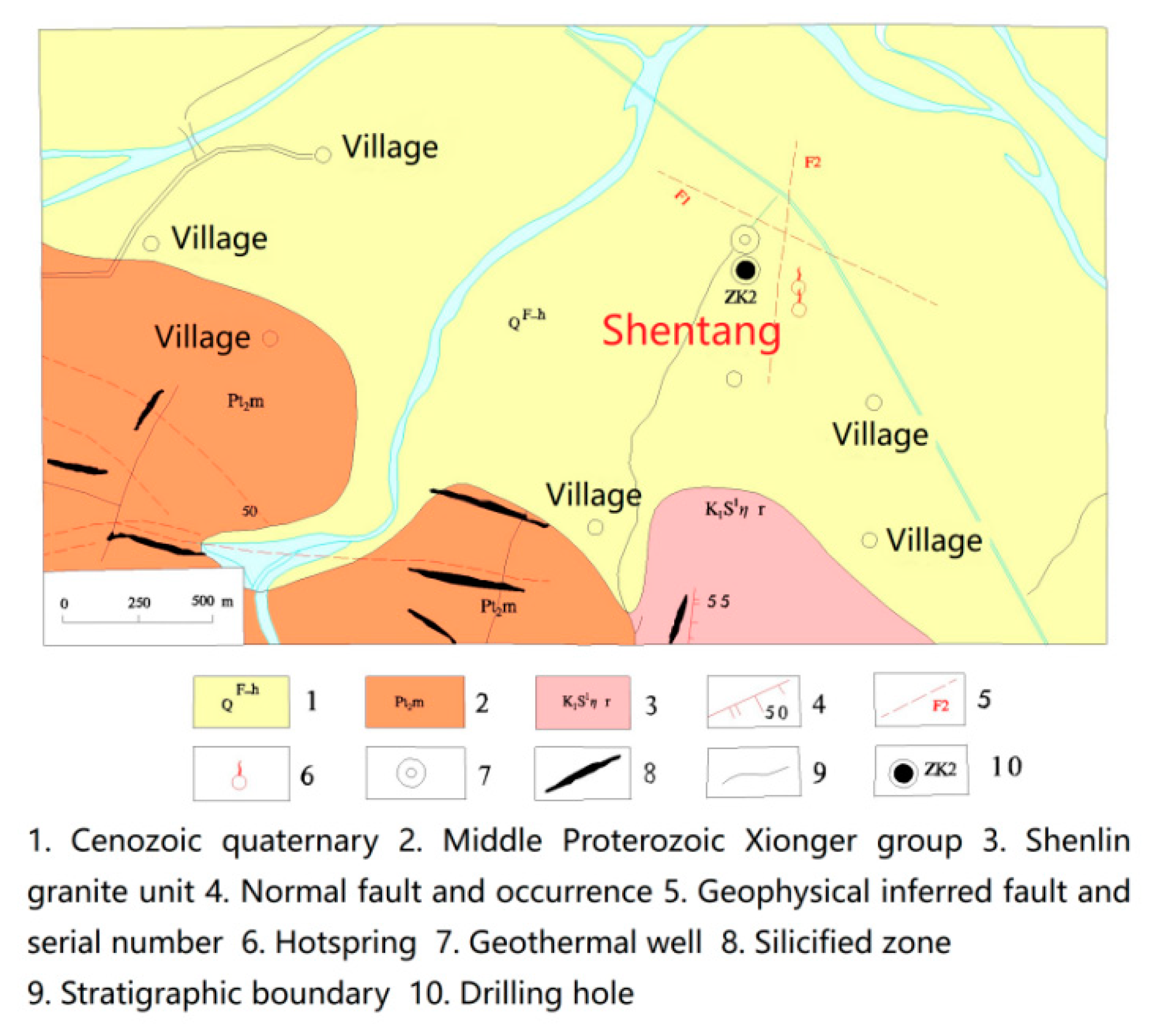
3.2.4. Geological Characteristics of Shentang Geothermal Field
- (a)
- General Situation of Shentang Hotspring
- (b)
- Geological Structure Characteristics of Shentang Hotspring
- (c)
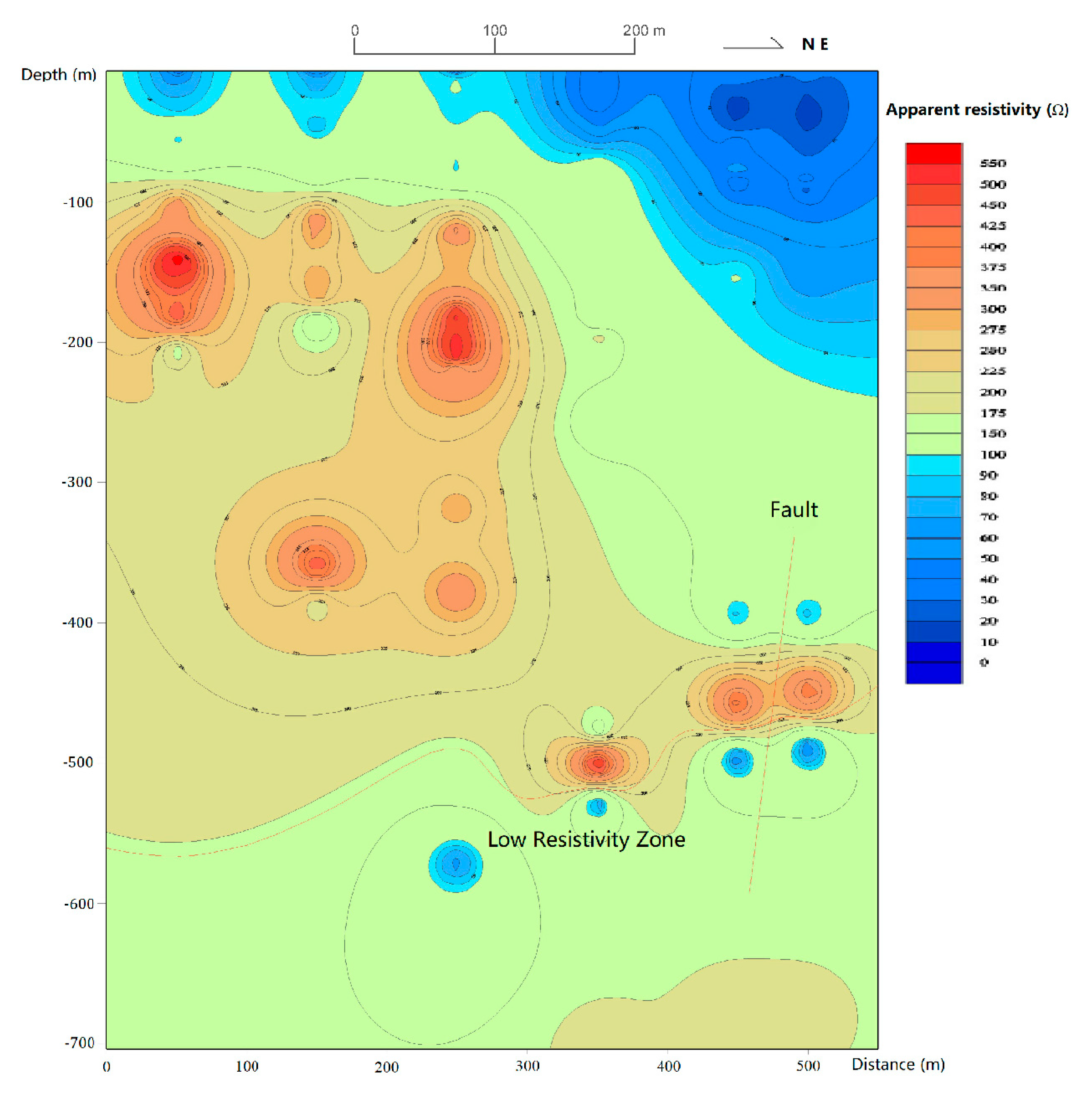
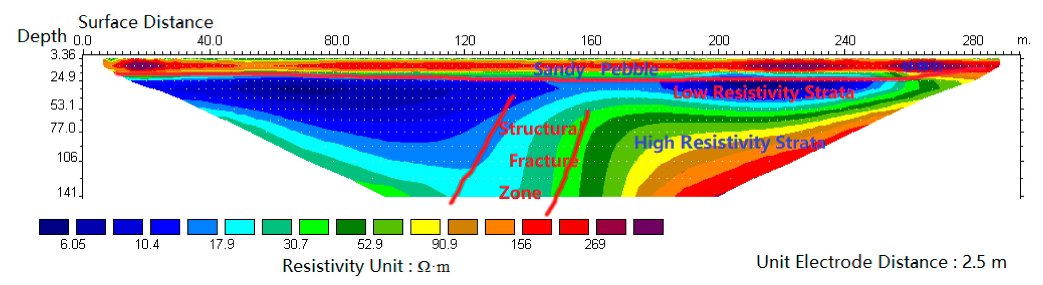
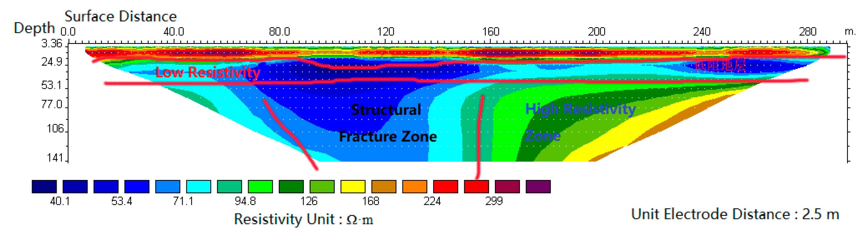
- Geophysical Characteristics of Shentang Hotspring
- (i)
- Magnetotelluric Sounding (EH-4) Characteristics
- (ii)
- Resistivity Characteristics
- (iii)
- Polarizability Characteristics
- (d)
- Geological Drilling and Pumping Test
4. Discussion
4.1. Formation Mechanism of Lushan Geothermal Belt
4.1.1. Geothermal Water Recharge
- (a)
- Surface Water
- (b)
- Groundwater
4.1.2. Water Storage Space
4.1.3. Heat Source
- (a)
- Deep Heat Energy of Crust
- (b)
- Magmatic Heat Sources
- (c)
- Shear Structural Heat
4.1.4. Water Gushing Structure
4.2. Assessment of Geothermal Resources
4.2.1. Natural Recharge of Geothermal Water
4.2.2. Exploitable Quantity of Geothermal Water
- (a)
- Minimum Exploitable Quantity
- (b)
- Maximum Exploitable Quantity
4.2.3. Assessment of Geothermal Energy
5. Conclusions
- Lushan geothermal springs are exposed in the Checun-xiatang deep fault zone. The Checun-Xiatang deep fault zone is the northern boundary of Lushan geothermal belt, the Erlangmiao-Wentang fault zone and Shuimozhuang-Lichun fault zone are its southern boundary, and the Modaling-Huanghuai watershed is its western boundary. The Checun-Xiatang fault and its parallel secondary near East-West faults are the primary heat control and conduction structures, which are the main channels for upward convection of deep heat sources; the north-east faults are the secondary heat conduction and water conduction structures, which control the outcropping of five hot springs.
- Lushan geothermal (hot spring) belongs to uplift fracture type, convection type, fracture vein type geothermal artesian water. It has no good heat insulation overburden, and is mainly recharged by atmospheric precipitation. Hydrochemical type of Shentang hot spring water belongs to HSiO4-HCO3-Na, and the others belong to HCO3-SO4-Na type. The temperature and quantity of all geothermal spring water are hardly affected by seasons. The results of geophysical exploration show that there is low resistivity layer in the 600–800 m underground, which is supposed to be the reservoir of geothermal water.
- The water temperature of Shangtang, Zhongtang, and Xiatang hot springs is from 60 to 90 °C, which belongs to the hot water of low-temperature geothermal resources. The water temperature of Wentang and Shentang hot springs is from 40 to 60 °C, which belongs to the warm water of low-temperature geothermal resources. The minimum recoverable amount of Lushan geothermal field is 397.94 m3/h, and the maximum value is 671.4 m3/h. The annual recoverable heat energy is 4.41 × 10¹¹ MJ.
Author Contributions
Funding
Acknowledgments
Conflicts of Interest
References
- Ebrahimi, D.; Nouraliee, J.; Dashti, A. Assessing the geothermal potential of the Shahin Dezh Region, based on the geological, geochemical and geophysical evidence. J. Afr. Earth Sci. 2019, 152, 84–94. [Google Scholar] [CrossRef]
- Babaa, A.; Şaroğlub, F.; Akkuşb, I.; Özelc, N.; Yeşilnacard, M.İ.; Nalbantçılare, M.T.; Demira, M.M.; Gökçena, G.; Arslane, Ş.; Dursund, N.; et al. Geological and hydrogeochemical properties of geothermal systems in the southeastern region of Turkey. Geothermics 2019, 78, 255–271. [Google Scholar] [CrossRef]
- Barcelonaa, H.; Lellib, M.; Norellib, F.; Peric, G.; Winocura, D. Hydrochemical and geological model of the Bañitos-Gollete geothermal system in Valle del Cura, main Andes Cordillera of San Juan, Argentina. J. S. Am. Earth Sci. 2019, 96, 102378. [Google Scholar] [CrossRef]
- Millett, J.M.; Planke, S.; Kästner, F.; Blischke, A.; Hersir, G.P.; Halldórsdóttir, S.; Flóvenz, Ó.G.; Árnadóttir, S.; Helgadóttir, H.M.; Vakulenko, S.; et al. Sub-surface geology and velocity structure of the Krafla high temperature geothermal field, Iceland: Integrated ditch cuttings, wireline and zero offset vertical seismic profile analysis. J. Volcanol. Geotherm. Res. 2018, 3, 06342. [Google Scholar] [CrossRef] [Green Version]
- Carrasco-Núnez, G.; López-Martínez, M.; Hernández, J.; Vargas, V. Subsurface stratigraphy and its correlation with the surficial geology at Los Humeros geothermal field, eastern Trans-Mexican Volcanic Belt. Geothermics 2017, 67, 1–17. [Google Scholar] [CrossRef]
- Tsuchiya, N.; Yamada, R. Geological and geophysical perspective of supercritical geothermal energy in subduction zone, Northeast Japan. Procedia Earth Planet. Sci. 2017, 17, 193–196. [Google Scholar] [CrossRef]
- Delgado-Outeiriño, I.; Araujo-Nespereira, P.; Cid-Fernández, J.A.; Mejuto, J.C.; Martínez-Carballo, E.; Simal-Gándara, J. Behaviour of thermal waters through granite rocks based on residence time and inorganic pattern. J. Hydrol. 2009, 373, 329–336. [Google Scholar] [CrossRef]
- Kloppmann, W.; Matray, J.M.; Aranyossy, J.F. Contamination of deep formation waters by drilling fluids: Correction of thechemical and isotopic composition and evaluation of errors. Appl. Geochem. 2001, 16, 1083–1096. [Google Scholar] [CrossRef]
- McCarthy, K.T.; Pichler, T.; Price, R.E. Geochemistry of Champagne Hot Springs shallow hydrothermal vent field and associated sediments, Dominica, Lesser Antilles. Chem. Geol. 2005, 224, 55–68. [Google Scholar] [CrossRef]
- Cerón, J.C.; Pulido-Bosch, A. Geochemistry of thermomineral waters in the overexploited Alto Guadalentín aquifer (South-East Spain). Water Res. 1999, 33, 295–300. [Google Scholar] [CrossRef]
- Tellam, J.H. Hydrochemistry of the saline groundwaters of the lower Mersey Basin Permo-Triassic sandstone aquifer, UK. J. Hydrol. 1995, 165, 45–84. [Google Scholar] [CrossRef]
- Rosenthal, E.; Guttman, J.; Sabel, R.; Moller, P. Limiting hydrochemical factors for sustainability of water resources: The Cisjordanian experience. Chem. Erde Geochem. 2009, 69, 191–222. [Google Scholar] [CrossRef]
- Sassani, D.C.; Shock, E.L. Solubility and transport of platinum-group elements in supercritical fluids: Summary and estimates of thermodynamic properties for ruthenium, rhodium, palladium, and platinum solids, aqueous ions, and complexes to 1000 °C and 5 kbar. Geochim. Cosmochim. Acta 1998, 62, 2643–2671. [Google Scholar] [CrossRef]
- Pentecost, A. The origin and development of the travertines and associated thermal waters at Matlock Bath, Derbyshire. Proc. Geol. Assoc. 1999, 110, 217–232. [Google Scholar] [CrossRef]
- Zhao, L.; Li, Y.; Wang, S.; Wang, X.; Meng, H.; Luo, S. Adsorption and transformation of ammonium ion in a loose-pore geothermal reservoir: Batch and column experiments. J. Contam. Hydrol. 2016, 192, 50–59. [Google Scholar] [CrossRef] [PubMed]
- Zhao, L.; Zhao, Y.; Wang, X.; Yang, J.; Luo, S.; Tian, Y.; Zhen, X. Dynamic changes of dissolved organic matter during nitrate transport in a loose-pore geothermal reservoir. Chem. Geol. 2018, 487, 76–85. [Google Scholar] [CrossRef]
- Kandaa, I.; Fujimitsub, Y.; Nishijima, J. Geological structures controlling the placement and geometry of heat sources within the Menengai geothermal field, Kenya as evidenced by gravity study. Geothermics 2019, 79, 67–81. [Google Scholar] [CrossRef]
- Wang, G.; Wang, W.; Luo, J.; Zhang, Y. Assessment of three types of shallow geothermal resources and ground-source heat-pump applications in provincial capitals in the Yangtze River Basin, China. Renew. Sustain. Energy Rev. 2019, 111, 392–421. [Google Scholar] [CrossRef]
- Aranzabal, N.; Martos, J.; Steger, H.; Blum, P.; Soret, J. Temperature measurements along a vertical borehole heat exchanger: A method comparison. Renew. Energy 2019, 143, 1247–1258. [Google Scholar] [CrossRef]
- Lin, D.T.W.; Hsieh, J.C.; Shih, B.Y. The optimization of geothermal extraction based on supercritical CO2 porous heat transfer model. Renew. Energy 2019, 143, 1162–1171. [Google Scholar] [CrossRef]
- An, Q.; Wang, Y.; Zhao, J.; Luo, C.; Wang, Y. Direct utilization status and power generation potential of low-medium temperature hydrothermal geothermal resources in Tianjin, China: A review. Geothermics 2016, 64, 426–438. [Google Scholar] [CrossRef]
- Park, S.; Yun, S.; Chae, G.; Hutcheon, I.; Koh, Y.; So, C.; Choi, H. Temperature evaluation of the Bugok geothermal system, South Korea. Geothermics 2006, 35, 448–469. [Google Scholar] [CrossRef]
- Morgan, P. A simple model of gravitationally-driven water flow in a semicircular aquifer to estimate geothermal power potential: Examples from Arizona and Colorado. Geothermics 2016, 64, 28–41. [Google Scholar] [CrossRef]
- Cheng, W.; Wang, C.; Nian, Y.; Han, B.; Liu, J. Analysis of influencing factors of heat extraction from enhanced geothermal systems considering water losses. Energy 2016, 115, 274–288. [Google Scholar] [CrossRef]
- Palabiyik, Y.; Onur, M.; Tureyen, O.I.; Cinar, M. Transient temperature behavior and analysis of single-phase liquid-water geothermal reservoirs during drawdown and buildup tests: Part I. Theory, new analytical and approximate solutions. J. Pet. Sci. Eng. 2016, 146, 637–656. [Google Scholar] [CrossRef]
- Reeves, R.; Rae, L. Changes in aerial thermal infrared signature over the Rotorua Geothermal Field, New Zealand: 1990–2014. Geothermics 2016, 64, 262–270. [Google Scholar] [CrossRef]
- Pang, J.; Pang, Z.; Lv, M.; Tian, J.; Kong, Y. Geochemical and isotopic characteristics of fluids in the Niutuozhen geothermal field, North China. Environ. Earth Sci. 2018, 77, 12. [Google Scholar] [CrossRef]
- Lu, L.; Pang, Z.; Kong, Y.; Guo, Q.; Wang, Y.; Xu, C.; Gu, W.; Zhou, L.; Yu, D. Geochemical and isotopic evidence on the recharge and circulation of geothermal water in the Tangshan Geothermal System near Nanjing, China: Implications for sustainable development. Hydrogeol. J. 2018, 26, 1705–1719. [Google Scholar] [CrossRef]
- Mariner, R.H.; Evans, W.C.; Young, H.W. Comparison of circulation times of thermal waters discharging from the Idaho batholith based on geothermometer temperatures, helium concentrations, and 14C measurements. Geothermics 2006, 35, 3–25. [Google Scholar] [CrossRef]
- Siebert, C.; Ross, A.; McManus, J. Germanium isotope measurements of high-temperature geothermal fluids using double-spike hydride generation MC-ICP-MS. Geochim. Cosmochim. Acta 2006, 70, 3986–3995. [Google Scholar] [CrossRef]
- Delalande, M.; Bergonzini, L.; Branchu, P.; Filly, A.; Williamson, D. Hydroclimatic and geothermal controls on the salinity of Mbaka Lakes (SW Tanzania): Limnological and paleolimnological implications. J. Hydrol. 2008, 359, 274–286. [Google Scholar] [CrossRef]
- Bajjali, W.; Clark, I.D.; Fritz, P. The artesian thermal groundwaters of northern Jordan: Insights into their recharge history and age. J. Hydrol. 1997, 192, 355–382. [Google Scholar] [CrossRef]
- Han, Y.; Lo, Y.; Cheng, C.; Yu, W.; Nagarajan, D.; Liu, C.; Li, Y.; Chang, J. Calcium ion adsorption with extracellular proteins of thermophilic bacteria isolated from geothermal sites-A feasibility study. Biochem. Eng. J. 2017, 117, 48–56. [Google Scholar] [CrossRef]
- Okamotoa, K.; Asanumaa, H.; Ishibashia, T.; Yamayaa, Y.; Saishua, H.; Yanagisawaa, N.; Mogib, T.; Tsuchiyac, N.; Okamotoc, A.; Naganawad, S.; et al. Geological and engineering features of developing ultra-high-temperature geothermal systems in the world. Geothermics 2019, 82, 267–281. [Google Scholar] [CrossRef]
- Trumpy, E.; Manzella, A. Geothopica and the interactive analysis and visualization of the updated Italian National Geothermal Database. Int. J. Appl. Earth Obs. 2017, 54, 28–37. [Google Scholar] [CrossRef]
- Feng, Y.; Zhang, X.; Zhang, B.; Liu, J.; Wang, Y.; Jia, D.; Hao, L.; Kong, Z. The geothermal formation mechanism in the Gonghe Basin: Discussion and analysis. China Geolgy 2018, 3, 331–345. [Google Scholar] [CrossRef]
- Zhang, Q.; Chen, S.; Tan, Z.; Zhang, T.; Mclellan, B. Investment strategy of hydrothermal geothermal heating in China under policy, technology and geology uncertainties. J. Clean. Prod. 2019, 207, 17–29. [Google Scholar] [CrossRef]
- Nilsson, E.; Rohdin, P. Performance evaluation of an industrial borehole thermal energy storage (BTES) project-Experiences from the first seven years of operation. Renew. Energy 2019, 143, 1022–1034. [Google Scholar] [CrossRef]
- Schumachera, S.; Pieraub, R.; Wirth, W. Probability of success studies for geothermal projects in clastic reservoirs: From subsurface data to geological risk analysis. Geothermics 2020, 83, 101725. [Google Scholar] [CrossRef]
- Liu, B.; Malekian, R.; Xu, J. Groundwater Mixing Process Identification in Deep Mines Based on Hydrogeochemical Property Analysis. Appl. Sci. 2017, 7, 42. [Google Scholar] [CrossRef] [Green Version]
- Niu, X.; Yao, Y.; Sun, Y.; Luo, Z. Weathering Process of in Situ Granite and Particle Breakage Characteristics of Compacted Weathered Granite. Appl. Sci. 2018, 8, 1108. [Google Scholar] [CrossRef] [Green Version]


| Test Items | Shangtang Hotspring | Shangtang River Water | Zhongtang Hotspring | Wentang Hotspring | Xiatang Hotspring | Xiatang River Water | Shentang Geothermal Well |
|---|---|---|---|---|---|---|---|
| pH value | 8.48 | 7.41 | 8.7 | 8.62 | 7.42 | 7.04 | 7.91 |
| Mineralization degree (g/L) | 0.641 | 0.173 | 0.498 | 0.599 | 0.598 | 0.225 | 0.649 |
| Cl− (mg/L) | 22.41 | 5.02 | 22.68 | 21.36 | 33.02 | 6.62 | 33.8 |
| SO42− (mg/L) | 111.9 | 31.11 | 92.11 | 89.65 | 106.1 | 43.96 | 157.5 |
| HCO3− (mg/L) | 229.9 | 61.76 | 140.7 | 200.7 | 251.0 | 110.9 | 171.5 |
| CO32− (mg/L) | 10.12 | - | 13.5 | 13.5 | 0 | - | 0 |
| F− (mg/L) | 15.91 | 0.76 | 16.78 | 16.23 | 17.3 | - | 13.54 |
| Na+ (mg/L) | 120.0 | 11.8 | 126.0 | 148.0 | 180.0 | 12.80 | 160.0 |
| K+ (mg/L) | 3.75 | 1.99 | 4.71 | 4.23 | 7.5 | 2.66 | 6.7 |
| Ca2+ (mg/L) | 4.89 | 20.4 | 5.25 | 3.8 | 8.34 | 35.4 | 7.5 |
| Mg2+ (mg/L) | 0.9 | 3.37 | 0.26 | 0.044 | 0.42 | 7.27 | 0.22 |
| As− (mg/L) | 0.029 | - | 0.024 | 0.024 | 0.0011 | - | 0.0026 |
| Cu | <0.05 | - | <0.05 | <0.05 | <0.05 | - | <0.05 |
| Zn | <0.05 | - | <0.05 | <0.05 | <0.05 | - | <0.05 |
| Fe | <0.05 | - | <0.05 | <0.05 | <0.05 | - | <0.05 |
| Mn | <0.05 | - | <0.05 | <0.05 | <0.05 | - | <0.05 |
| U (g/L) | <2.0 × 10⁻⁷ | - | 1.40 × 10⁻⁷ | - | - | - | - |
| Ra (g/L) | 1.99 × 10⁻¹² | - | 8.20 × 10⁻¹² | - | - | - | - |
| Hydrochemical type * | A-HCO3-Na | A-HCO3-Ca·Na | A-HCO3-Na | - | A-HCO3-Na | A-HCO3-Ca | - |
| Serial No. of Well | Water Level (m) | Q (m3/h) | q (m3/h·m) | t (°C) | Daily Water Output (m3/d) |
|---|---|---|---|---|---|
| 1 | 15.0 | 184.3 | 12.2 | 61.0 | |
| 2 | 14.0 | 73.1 | 5.22 | 61.0 | |
| 3 | 11.2 | 23.0 | 2.05 | 61.0 | |
| Total water output | 280.4 | 6731.0 |
| Depth of Drilling Hole (m) | Temperature (°C) | Artesian Flow (m3/h) | Depth of Drilling Hole (m) | Temperature (°C) | Artesian Flow (m3/h) |
|---|---|---|---|---|---|
| 1.6 | 31 | 0 | 29.05 | 61 | 78.00 |
| 3.0 | 37 | 0 | 31.0 | 61 | 104.00 |
| 6.91 | 43 | 0 | 41.0 | 61 | 126.00 |
| 8.0 | 55 | 1.00 | 50.0 | 61 | 133.00 |
| 10.57 | 57 | 1.00 | 60.0 | 61 | 133.00 |
| 14.0 | 58 | 6.00 | 61.9 | 61 | 140.19 |
| 16.94 | 60 | 18.01 | 67.4 | 61 | 133.00 |
| 23.0 | 60 | 18.01 | 81.18 | 61 | 137.29 |
| Geothermal Field | Shangtang | Zhongtang | Wentang | Xiatang | Shentang | Total |
|---|---|---|---|---|---|---|
| Recoverable Mount (m3/h) | 280.4 | 13.94 | 2.0 | 250.0 | 125.0 | 671.34 |
| Recoverable Heat (kW) | 15,098.7 | 783.1 | 58.8 | 14,043.2 | 5131.7 | 35,115.5 |
| Annual Recoverable Heat Energy (MJ) | 1.89 × 10¹¹ | 9.83 × 10⁹ | 7.39 × 10⁸ | 1.76 × 10¹¹ | 6.44 × 10¹⁰ | 4.41 × 10¹¹ |
| Equivalent to Standard Coal (t/a) | 6.45 × 10⁶ | 0.34 × 10⁶ | 0.025 × 10⁶ | 6.01 × 10⁶ | 2.20 × 10⁶ | 15.05 × 10⁶ |
© 2020 by the authors. Licensee MDPI, Basel, Switzerland. This article is an open access article distributed under the terms and conditions of the Creative Commons Attribution (CC BY) license (http://creativecommons.org/licenses/by/4.0/).
Share and Cite
Zhang, Q.; Bin, Z.; Xu, Y.; Luo, S.; Zhao, L.; Qian, J. Geological Formation Mechanism and Thermal Resources Assessment of Geothermal Spring in Lushan County, China. Appl. Sci. 2020, 10, 592. https://doi.org/10.3390/app10020592
Zhang Q, Bin Z, Xu Y, Luo S, Zhao L, Qian J. Geological Formation Mechanism and Thermal Resources Assessment of Geothermal Spring in Lushan County, China. Applied Sciences. 2020; 10(2):592. https://doi.org/10.3390/app10020592
Chicago/Turabian StyleZhang, Qing, Zhaohui Bin, Yongji Xu, Shaohe Luo, Li Zhao, and Jiazhong Qian. 2020. "Geological Formation Mechanism and Thermal Resources Assessment of Geothermal Spring in Lushan County, China" Applied Sciences 10, no. 2: 592. https://doi.org/10.3390/app10020592