Article

Metal Mobility in Afforested Sites of an Abandoned Zn-Pb Ore Mining Area

by
Urszula Aleksander-Kwaterczak
* and
Dariusz Ciszewski
Faculty of Geology, Geophysics and Environmental Protection, AGH University of Science and Technology, al. A. Mickiewicza 30, 30-059 Krakow, Poland
*
Author to whom correspondence should be addressed.
Appl. Sci. 2020, 10(17), 6041; https://doi.org/10.3390/app10176041
Submission received: 28 July 2020 / Revised: 26 August 2020 / Accepted: 27 August 2020 / Published: 31 August 2020
(This article belongs to the Special Issue Heavy Metals in the Environment – Causes and Consequences)

Abstract

:
Heaps of waste material constitute a serious environmental problem in regions where the historical exploitation and processing of metal ores has taken place. The presented paper describes the trace metal distribution in selected heaps in the lead-zinc mining area of an abandoned mine in Poland, as well as the soil horizons beneath. The study aims at the estimation of the metal remobilization rate in vertical profiles in the spontaneously afforested area in the context of the potential danger it poses to the local groundwater. Individual samples were taken from profiles dug in heaps found in deciduous and coniferous forests. The bulk density, pH, organic matter and carbonate content, as well as the concentration and chemical forms of metals were analysed. Buffer properties and the mineralogical composition were also determined for the selected samples. The investigation indicates excessive cadmium, zinc and lead concentrations in the analysed heap material and the significant secondary enrichment of former soil horizons. A large percentage of these metals occur in potentially mobile forms. It suggests that, despite the high pH of the heap material and the good buffer properties of soil, cadmium and to a lesser extent, zinc, has migrated downwards to depths of at least several dozen centimetres over a period of about 200 years. This is related to soil acidity, particularly in profiles abundant in organic matter resulting from the encroachment of forest communities, particularly of coniferous forest. Spontaneous afforestation forming the litter cover contribute to the stabilization of the heap material and limiting groundwater pollution. Even though specific remediation measures are not needed in this area, it requires long-term monitoring.

1. Introduction

Metal mining and smelting have played a very important role in economies since ancient times. A side effect of this exploitation would be the pollution which often accompanies it. Usually, it is associated with the release of a portion of excavated metals into the environment, both during ore exploitation and also long after the cessation of mining activity [1,2,3]. Particularly, metals stored in waste heaps can be dispersed into the surrounding soils and surface waters for a very long time afterwards due to erosion, weathering and leaching processes [4,5]. For these reasons, heaps of waste material constitute a serious environmental problem in regions throughout the world which have witnessed the historical exploitation and processing of metal ores [6,7,8,9].
Afforestation is the most common reclamation method of lands degraded by mining, particularly in previously forested regions [10]. Nonetheless, at abandoned historical mines where landform alignment, the placement of overburden and/or soil capping have not been undertaken, afforestation usually results from natural succession [11]. Establishing forest cover leads to the modification of the soil profile [12], elevated amounts of organic detritus and concentrations of dissolved organic matter [13,14] as well as a drop in pH and the depletion of cations in the topsoil [15]. Subsequently, the production of organic matter and the associated drop in the pH of the topsoil favour the mobilization and transport of metals down soil profiles [16,17]. For this reason, the mobility of elements in many forest soils was evidenced to be higher than in arable soils [18] with higher migration rates found in coniferous rather than deciduous forests [17,19]. It suggests that metal remobilization rate in naturally afforested, highly metal-contaminated heaps differs from that observed in reclaimed areas and should be investigated more carefully.
The current study focuses on metal mobility in spoil heaps of the Katarzyna mine in southern Poland which was abandoned at the beginning of the 20th century. The Pb-Zn ore was extracted in shallow pits, no more than a dozen meters deep. They were located from a dozen to ca. hundred meters apart. In this area, remnants of more than 400 exploitation pits were found. Most of the area of the former mine was afforested naturally and the high content of heavy metals in plants suggest their high mobility [20]. In the profiles dug into the heaps found in deciduous and coniferous forests, we compared the content and speciation of the metals in the heap material with the material of the fossil soil horizons which are termed hereafter “former soil”. The study aimed at the estimation of the metal remobilization rate based on metal distribution and soil properties in six vertical profiles in both forest types in the context of the potential danger posed to local groundwater.

2. Materials and Methods

2.1. Research Area

In the Silesian–Krakow region of southern Poland, Zn-Pb ore mining has a centuries-old history, with the beginnings of its exploitation dating as far back as 700–400 BC [21]. This region belongs to Europe’s oldest mining areas, but the archival documents indicate that ore mining only developed rapidly from the 13th century onwards. Generally, from the 13th to the 15th centuries, silver-bearing galena was exploited in shallow shafts whereas, from the 15th to the 19th century, deeper ore beds became accessible in some locations thanks to the construction of adits. In this period, Olkusz was one of the most important centres of lead and silver production in Europe [22]. At the beginning of the 19th century, the Katarzyna mine was built in the southern part of the region, encompassing an area of about 5 km2. The mine operated until 1912, when the metal ores were exhausted [23].
The extracted ore beds of the Mississippi Valley-type occurring in Triassic and Devonian rocks contained chiefly zinc, lead and iron sulphides with 4–6% of Zn, 1–3% of Pb and 5–8% of Fe and with smaller amounts of Cd, Tl, Ag and As. The partial oxidation of the primary ore minerals, i.e., sphalerite and wurtzite (Zn), galena (Pb), pyrite and marcasite (Fe) lead to the formation of smithsonite, cerusite, monheimite and limonite. The waste rock minerals are mainly composed of dolomite and calcite. They account in total for approx. 70% of mining output [21,24]. The rest consist mainly of sand and clay.
The material excavated during the mine operation was piled up around pits forming ring-shaped heaps that are 2–5 m high. The diameter of some of the former pits reaches 20 m, with depths of up to 7 m. However, most of the holes do not represent their original dimensions and holes that are about 2 m in diameter predominate [25,26]. Heaps consist of the overburden and gangue, often containing metal-rich material [23,27]. The studied site was located in the southern part of the Silesian-Krakow region (S Poland) at two localities: Paryz and Lgota (Figure 1). The area of the investigated heap at Paryz is overgrown with mixed forest with a predominance of pine trees, whereas the area of the heap at Lgota is overgrown with beech forest. Rendzinas are the dominant group of soils in the Lgota region, while sandy soils dominate in the area of Paryz. The soils in the heaps could be classified as anthropogenic ones. Heaps were outcropped with a spade to the depth of a few dozen centimetres below the previous ground surface marked in each profile by the visible change in stratigraphy. At each locality, three outcrops were dug at different distances from the centre of the heap (Figure 1).
Generally, the deepest outcrops were located at the point where the heaps were raised about 1.5 m above the ground surface. The next ones, in the middle part of the escarpment, were raised a few dozen centimetres above the surface and the last were located at the foot of the heaps where the mined material was about a dozen cm thick (Figure 1). The depth of outcrops ranged from between 2.8 and 0.5 m and depended on the thickness of the rubble material and that of the buried primary organic layer. The vertical profiles were taken in each outcrop. Individual samples were collected according to the lithology, packed separately, appropriately marked and transported to the laboratory.

2.2. Laboratory Analyses

In the individual raw samples, the bulk density, pH after extraction with water (pHH2O) at a 1:5 (w:v) ratio [28] and after extraction with 1 M KCl (pHKCl) at a 1:5 (w:v) ratio, water content (loss of mass at 105°C) and organic matter as losses on ignition (LOI) at 550°C (in a laboratory muffle furnace) were estimated. Carbonate content was determined by means of the weight method at 925°C (laboratory muffle furnace) as well as by the volumetric method using a Scheibler apparatus (according to [29]). The grain-size of samples was estimated by the sieve method. Before the metal analysis, the soil samples were sieved using a 0.063-mm sieve and dried (105°C). The concentration of Cd, Cu, Fe, Mn, Pb and Zn—pseudo total (after digestion in an Microwave Digestion System 2000, Milestone-Sorisole, Italy, microwave oven in hot 65% HNO3 (p.a.)) and partitioning from sequential leaching phases (3-steps according to the BCR method [30], and as the fourth step with digestion in 65% HNO3 in an MDS 2000 microwave oven, Spectralab Scientific-Ontario, Canada) were determined using Atomic Absorption Spectrometry (F-AAS, iCE3000, Thermo Scientific-Waltham, MA USA).
The analyses were performed according to a standard certified analytical quality control procedure. Blanks and standard reference materials (River Sediment 1646) were analysed at regular intervals (one blank and one standard for each set). Each measurement was repeated three times. The RSD values for all the analysed metals were below 5%.
For the selected samples, buffer properties (Arrhenius method) and the mineral composition (XRD method) were determined. The mineral composition of the samples was carried out by X-ray with the Debyea-Sherrer powder method. X-rays of all samples were recorded using a Rigaku SmartLab X-ray-Tokyo, Japan, diffractometer using the following parameters: Cu radiation, reflective graphite monochromator, lamp voltage 45 kV, the lamp current 200, step recording: step = 0.050 2Θ, counting time per step = 1 s. Preparations were made using the “front-loading” method. The ICDD catalogue (International Centre for Diffraction Data 2014) and the XRAYAN computer program (4.0.1 version) were used to identify the mineral phases of the samples.

3. Results

3.1. Soil Characteristics

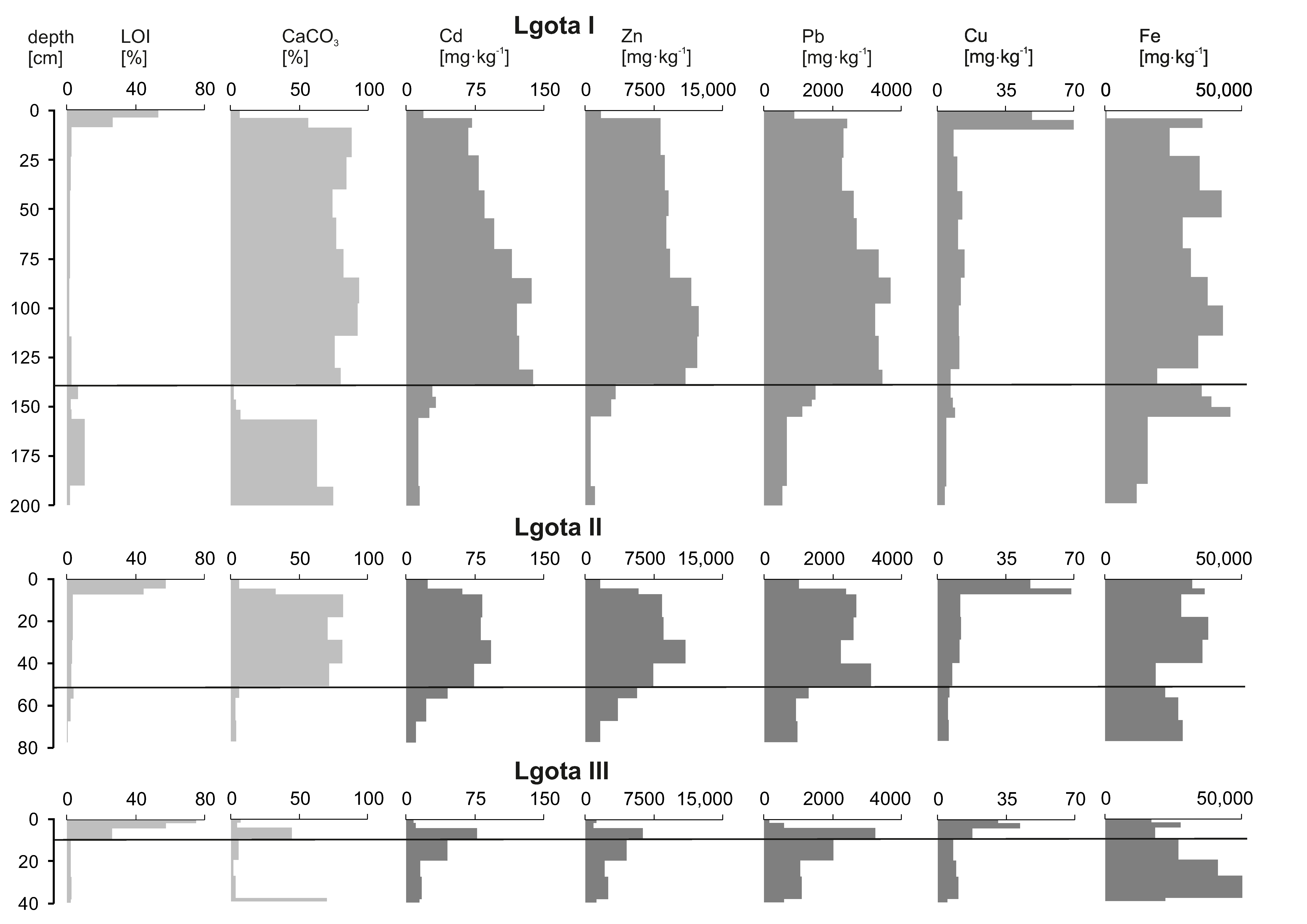
3.1.1. Profiles from the Heap at Lgota

The depth of the soil profile I from the heap at Lgota (Figure 1) equals 2 m. Black humus of a very low bulk density (about 0.4 g·cm−3) constitutes the top 7 cm stratum of the profile. pHKCl in this layer is lower than 6.1, while water (about 50%) and organic matter contents (expressed as LOI value—53%) are the highest of all the samples in this profile. The content of carbonates in this stratum is relatively low (6.53%). Below the 7-cm top layer, there is a 1.30-m-thick layer of yellow loam with loosely dispersed fine stones up to several cm in diameter. Its bulk density varies from 0.88 to 1.13 g·cm−3. pHKCl changes from 7.1 to 8.0, water ranges between 20% and 27% and organic matter content is between 1.53% and 2.46%. The carbonate content is very high and changes from 74.3% to 88.2%. These strata are intercalated with grey loams containing a large number of rock crumbs. pHKCl attains a value of 8.5, with the bulk density of 1.21 g·cm−3, while LOI is only about 1.2% and carbonate content is higher than 90%. At a depth of 1.38–1.44 m, an increase concerning overlying layers in LOI value (6.3%) and a drop in calcium carbonate content (to 2.3%) is observed. The silty loam that occurs there also has a lower pH and reduced water content in comparison to the overlying ones. The lower-lying strata (1.44–1.54 m) have a density of about 0.94 g·cm−3, slightly alkaline pHKCl (7.13–7.36), and a low LOI (2.1–2.8%) and carbonate content (4.0–7.1%) (Table 1). At the depth of 1.54–2.00 m, weathered limestone rock debris appears again and the density, pH and LOI increase slightly. However, a large increase (to about 75%) in the carbonate content is observed in this stratum in relation to the overlying soil.
The Lgota II profile, sampled from the middle height of the heap, is 0.82 m deep. As in the case of the previous profile, a 7-cm-thick humic, dark layer appears on the surface. Its bulk density is about 0.5 g·cm−3 and it is characterised by pHKCl from 5.1 to 5.8, relatively high water content (about 50%) and a LOI value of about 50%. The carbonate content is relatively low and varies from 5.7 to 32.9%. In the underlying brown layer, at a depth from 0.07 to 0.57 m, there are some fragments of carbonate rock up to a few cm in diameter. Carbonate enrichment is reflected by the increase in pHKCl to 6.7 and carbonate content reaching 82%. The bulk density reaching 1.48 g·cm−3 is much higher than in the overlying strata, while a water content of about 25% and the LOI value of about 3% is much lower. The part of the core from the depth 0.57 to 0.82 cm is characterised by high density (to 1.74 g·cm−3) dark brown silts with a low concentration of carbonates (about 4%) and organic matter (to 0.2%) (Table 1).
The Lgota III profile, dug to a depth 0.4 m, was located 3 m from the previous profile. The dark coloured humus layer on the profile top is about 0.1 m thick but the values of the organic matter decrease from 75.3% to 26.2% and pHKCl from 4.6 to 6.1 with depth. Conversely, the concentration of carbonates is relatively low and changes from 4.5% to 44.3%. Below this level, at the depth 0.1–0.3 m, there is a reddish-brown sandy loam layer with a relatively high bulk density (up to 1.86 g·cm−3), which is slightly acidic and contain a low concentration of organic matter (about 2.5%) and carbonate content (on average, 3.5%). In the deepest part of the profile (0.3–0.4 m), there is a stratum with fragments of crushed rock and the highest concentration of carbonates in the whole profile (70.3%) and pHKCl (6.7) (Table 1).

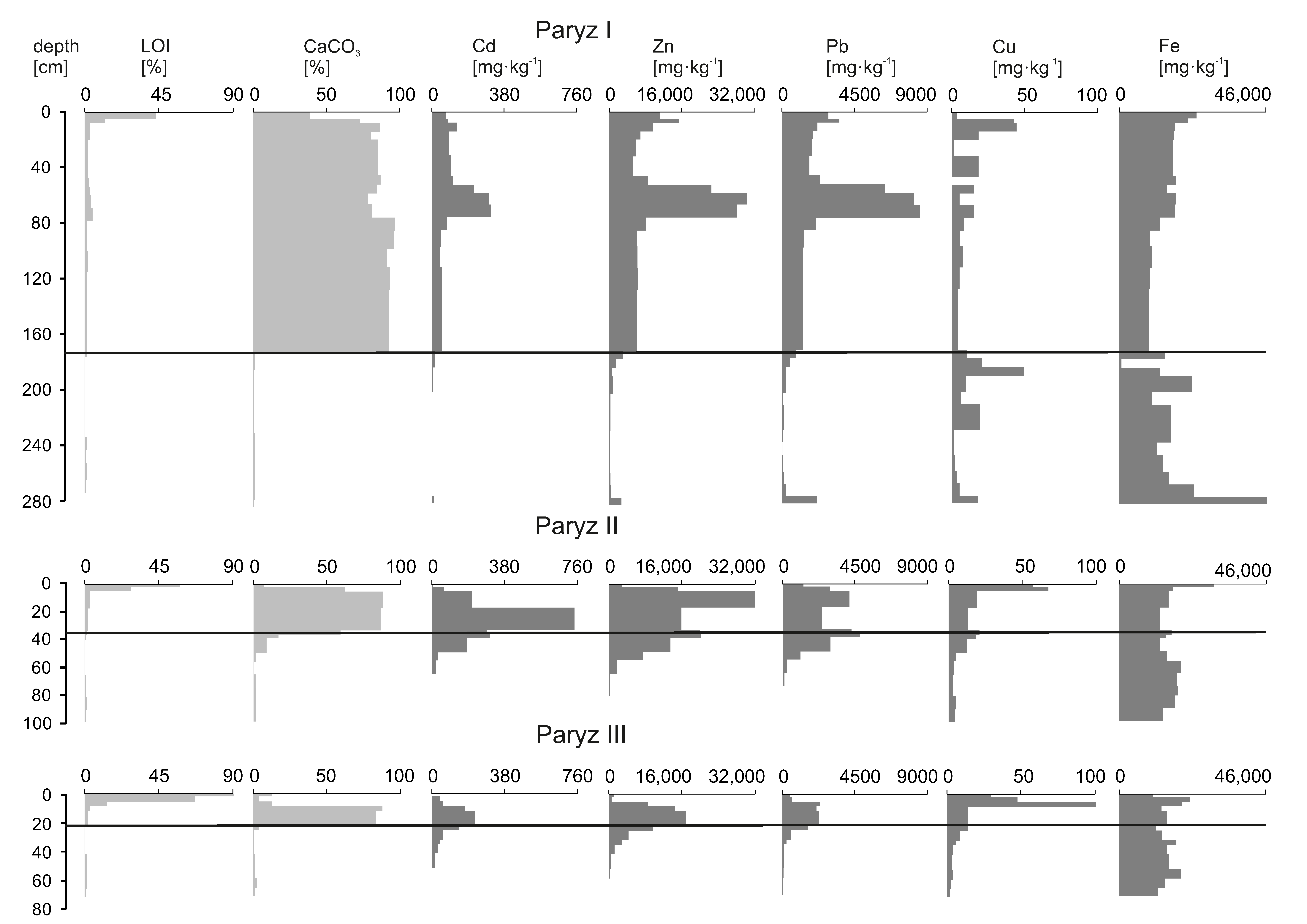
3.1.2. Profiles from the Heap at Paryz

Profile I at Paryz is 2.82 m deep. The 4 cm dark organic surface stratum has a very low density (0.55 g·cm−3). It is characterised by a pHKCl = 6.8. The organic matter (43.3%) and water (53%) content is higher, whereas the concentration of carbonates is lower (38.6%) in comparison with the rest of the profile. The lower levels of the profile, from 0.04 to 1.72 m, contain yellow silty sands with carbonate content which increases with depth from 73% to 97%. The soil pH values exhibit an analogous regularity, rising from 6.6 to 8.7. The bulk density of this strata is around 1 g·cm−3 whereas LOI is equal to 3%. The highest carbonate content and pH values are at the depth from 0.74 to 1.72 m where fragments of dolomites were found. The deeper part of the profile (from 1.72 to 2.26 m) contains brown sands with the low content of carbonates (<1%) and organic matter (<0.25%). These strata have a relatively high density (1.1–1.3 g·cm−3), pHKCl from about 6.5 to 6.8 and the low content of water (about 5%). Under these layers, at the depth of 2.26 m, a sandy stratum about 0.3 m thick with a higher concentration of organic matter and pHKCl about 6.3 occurs (Table 2). In the deepest part of the profile (below 2.65 m), both organic matter and carbonates disappear.
The Paryz II profile was sampled to the depth of 0.96 m below the heap surface (Figure 1). The dark humus top stratum is 6 cm thick. It is characterised by the LOI value of 58%, the water content of 56%, very low bulk density (0.52 g·cm−3), a pH value of 5.0 and carbonate content equal to 47.4%. Immediately below the organic layer, at depths from 0.06 to 0.34 m, there is a yellowish layer with visible crumbs of weathered dolomites in which the CaCO3 concentration ranges from 86 to 88% and pHKCl from 6.7 to 7.0. Below, at a depth of 0.34 m, there are 0.3-m-thick sandy deposits in which contents of organic matter (2.0–0.3%), carbonates (58.9–0.62%) and water (18.2–0.4%) is lower while the pH is 7.0. Silty-clay deposits with a variable proportion of sand fraction compose the bottom part of the profile (0.64–0.96 m). It is characterised by a very low amount of both organic matter (about 1%) and calcium carbonate (about 2%). The bulk density of this ground is the highest in the whole profile and reaches 1.75 g·cm−3 (Table 2).
The Paryz III profile was sampled to the depth of 0.67 m. The dark humus 6-cm-thick top stratum has a very high LOI value (93.3%) and low pHKCl (3.3) while water content is only about 9%. At the depth 0.1–0.2 m, there are yellow loams with rocky debris with a high CaCO3 content (about 85%) and a pH value (pHKCl) of about 6.8. Below this depth, there is a sandy brown stratum with a clay fraction characterised by the minimum content of organic matter and carbonates in the profile as well as a high density (up to 2.0 g·cm−3) (Table 2).

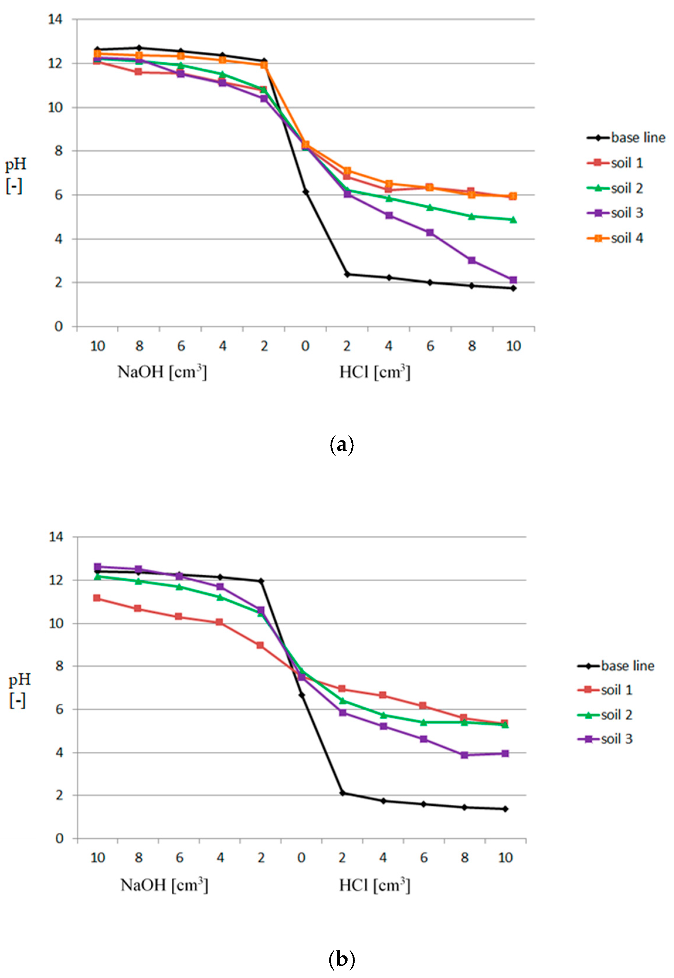
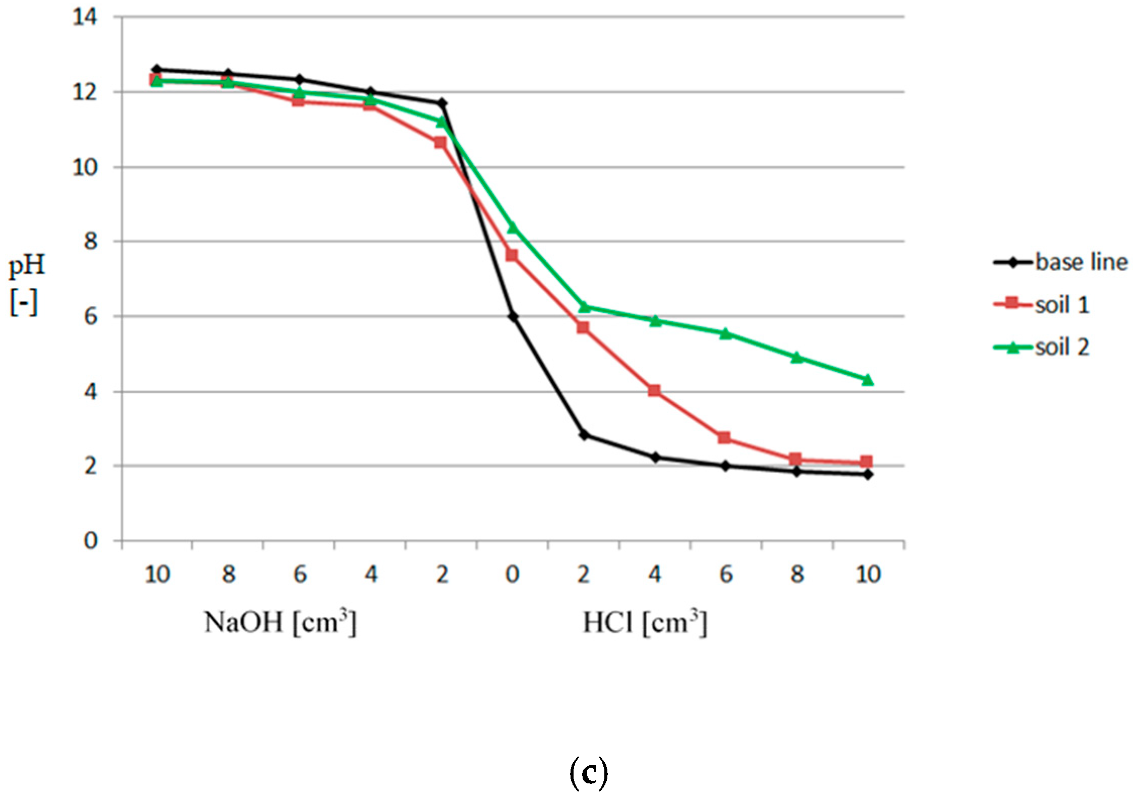
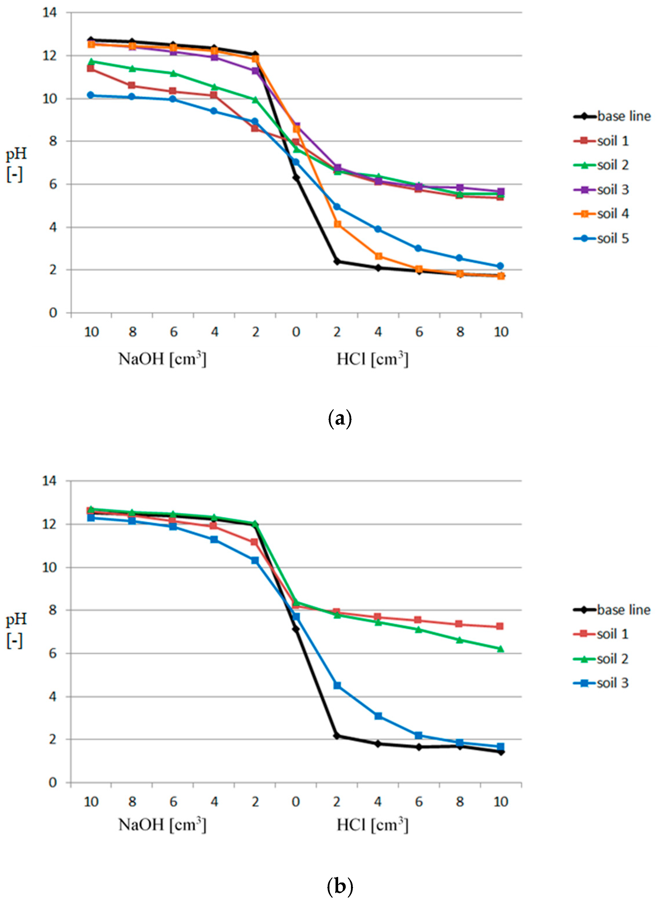
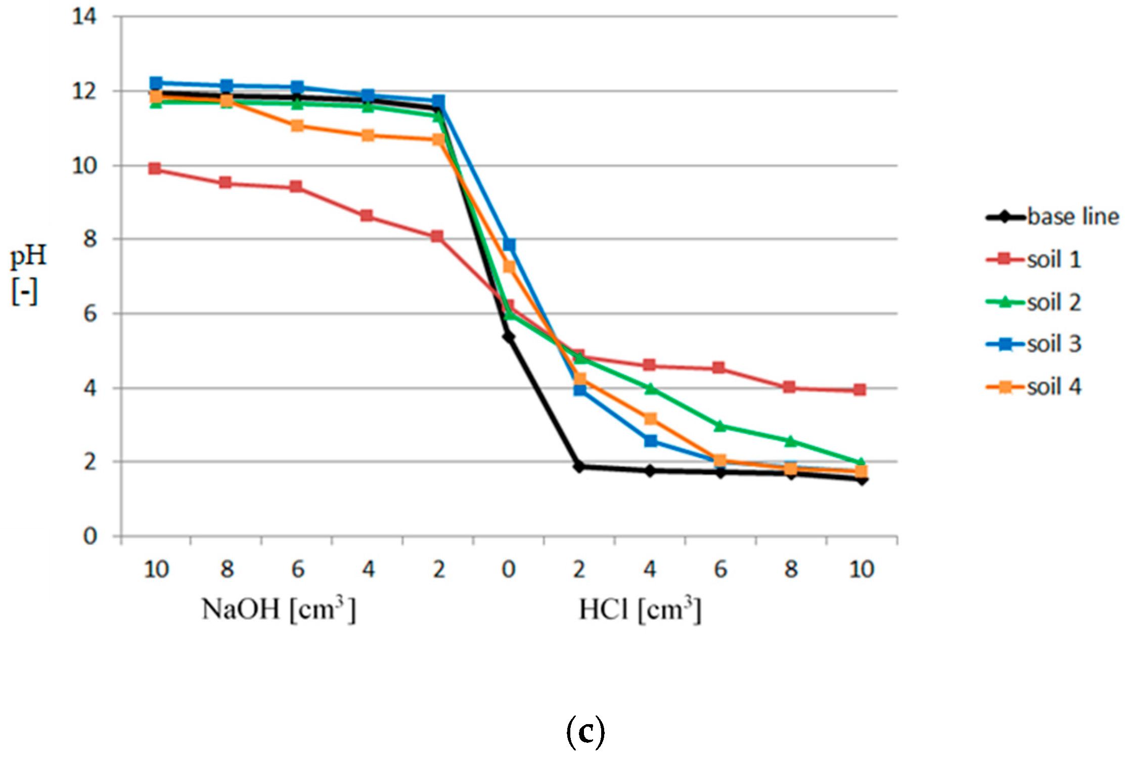
3.2. Buffer Capacity

Buffer capacity curves are presented in Figure 2 and Figure 3. The base black lines represent pH measurements for the blank samples. Soils in the Lgota I profile (Figure 2a) generally have a very weak buffer capacity relative to alkalizing agents and a good buffer capacity related to high calcium carbonate content. The exception is the stratum at a depth 138–144 cm, where a drop of buffer capacity to 2.5% is in parallel to a significant decrease in CaCO3 concentration. Generally, in the Lgota II core (Figure 2b), buffer properties follow the values observed for the Lgota I profile, whereas in the Lgota III profile, the buffer capacity in the upper sandy loam stratum is lower than in the strata enriched in crushed carbonate rocks beneath (Figure 2c).
The soils in the Paryz I profile (Figure 3a) have a very good buffer capacity for acidifying agents in strata enriched with carbonate rocks whilst a good buffer capacity in relation to alkalizing agents only appears in the uppermost and deepest parts of the profile. The soil in the Paryz II profile shows good buffer properties only relative to acidifying agents in strata abundant in carbonate rocks (Figure 3b). The soil in the Paryz III profile has the best buffer capacity in the subsurface strata, being abundant in organic material (Figure 3c).

3.3. Metal Concentrations

3.3.1. The Heap at Lgota

The metal content varies depending on the profile depth and location. In the deepest Lgota I profile, located closest to the centre of the heap, there is a progressive increase in the concentrations of all investigated metals to the depth of about 130 cm. Below this horizon, concentrations drop several times. The maximum concentrations of Zn, Cd and Pb are 12,433 mg·kg−1, 138 mg·kg−1 and 3692 mg·kg−1, respectively. A similar regularity has also been observed for the Lgota II profile but the maximum metal concentrations appear there already at a depth of 37–47 cm. The maximum values are slightly lower than in the Lgota I profile (Zn—10,923 mg·kg−1, Cd—93 mg·kg−1 and Pb—3117 mg·kg−1). The Lgota III profile, located at the heap periphery, is characterised by lower metal contents than the previous ones, and for Zn, Cd and Pb they reach 6260 mg·kg−1, 77 mg·kg−1 and 3233 mg·kg−1, respectively. The most polluted strata there is at the depth of 5–20 cm (Table 3, Figure 4).

3.3.2. The Heap at Paryz

In the heap at Paryz (Table 4; Figure 5), metal concentrations depend on the profile location to a lesser extent than in the heap at Lgota. In the Paryz I profile, analysed metal (except Cd) concentrations decrease from the top to the depth of 50 cm. Below, there is the sandy stratum about 25 cm thick containing carbonate debris, in which the content of metals increases rapidly. Zinc contents reach 330,305 mg·kg−1, cadmium 310 mg·kg−1 and lead 8583 mg·kg−1. At lower levels, concentrations of metals gradually continue to decrease with depth. In the Paryz II profile, the content of all metals increases to the depth of about 40 cm and then it gradually decreases. The maximum concentration of Zn and Cd attain higher values than in the previous profile and reach 31,816 mg·kg−1 and 742 mg·kg−1, respectively. In the Paryz III profile, concentrations of most metals rise to peak values at the depth ca. 20 cm and then decrease. However, the maximum concentrations of all analysed metals (except Cu) are lower than in the Paryz I and Paryz II profiles.

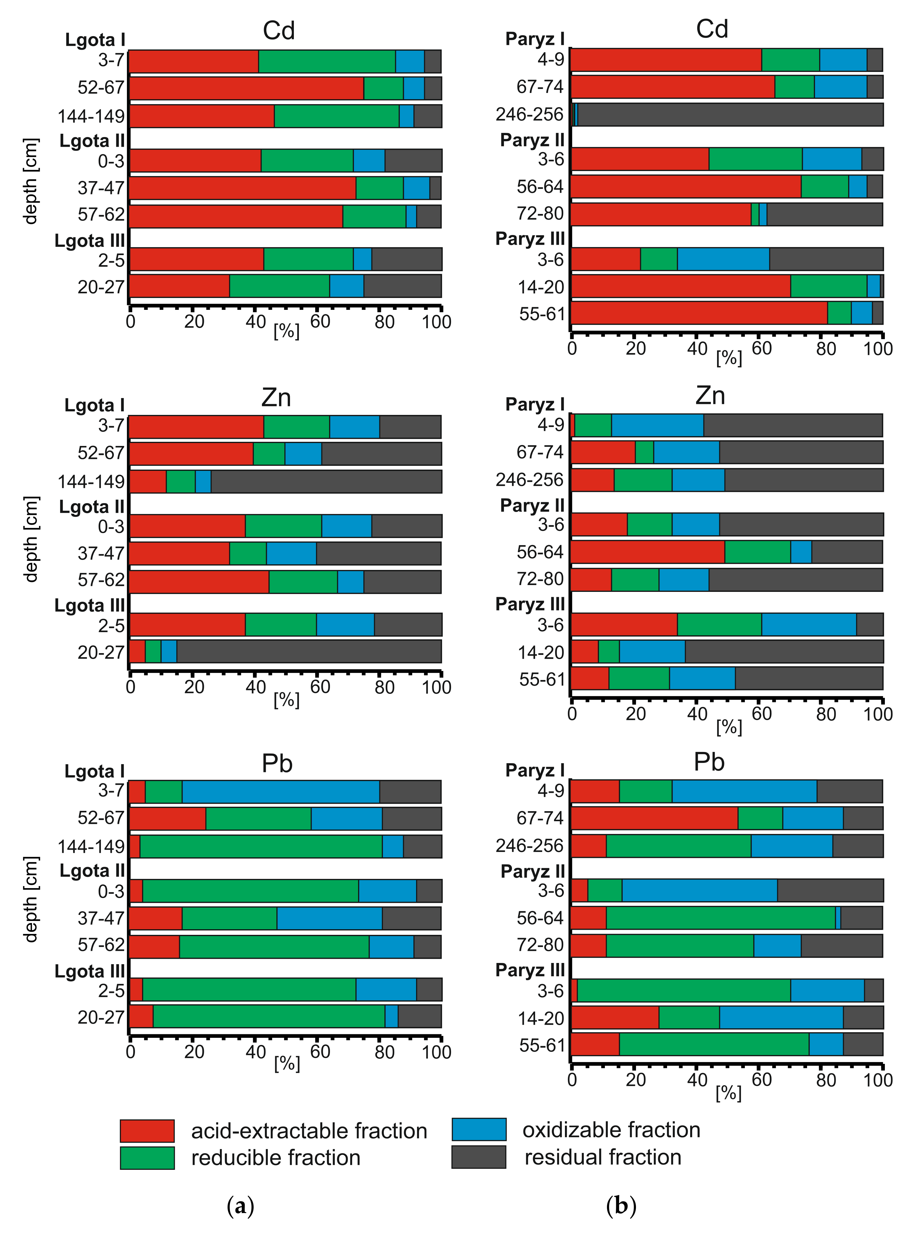
3.4. Metal Speciation

In the Lgota I profile (Figure 6a), three strata from different depths, characterised by their different mineralogical compositions, were selected for testing the chemical forms of Cd, Zn and Pb. The first is the organic stratum (3–7 cm), the second represents sands with dolomite debris (52–67 cm), whereas the third one is composed mainly of clays (144–149 cm). In each of them, the pHH2O is alkaline, while the pHKCl only drops below 7 in the organic layer. Throughout the profile, cadmium occurs mainly in highly mobile forms (Figure 6). Acid-extractable and -reducible forms of this metal constitute about 90% of its total content. Mobile forms of Zn constitute a smaller portion of its load, decreasing with depth from about 65% to 20%. In general, the share of mobile forms of Pb increases with depth from about 15% to 80% however, reducible forms dominate the most mobile acid-extractable forms.
Samples selected for analysis in the Lgota II profile (Figure 6a), resemble those of the Lgota I profile and contain (1) organic (0–3 cm), (2) sands with dolomite debris (37–47 cm) and (3) loams (57–62 cm). The pH values are generally slightly lower than in the respective samples from the heaps of Lgota I. Again, cadmium is the most mobile element, with the portion of highly mobile forms reaching 70% in organic strata and 90% in sandy and clayey ones. The share of mobile forms of Zn and Pb is lower. Whereas Zn bonding is dominated by the most mobile forms, Pb is associated mainly with the less mobile, reducible forms of the element.
In the shortest Lgota III profile (Figure 6a), only two strata were selected—organic (2–5 cm), with pHKCl = 4.6 and loam-dominated (20–27 cm) with pHKCl = 6.1. The portion of mobile forms of Cd and Zn is lower in loams than in organics whereas Pb occurs mainly in the reducible fraction, in similar amounts in both studied strata.
At Paryz (Figure 6b), the selection of profiles was made on the same basis and characteristics as at Lgota. The first is the organic stratum (4–9 cm), characterised in the Paryz I profile by a pHKCl = 6.6, the second being sands with carbonate debris (67–74 cm) with a pHKCl = 7.7 whereas the third contains sandy-loams from a greater depth (246–256 cm) with a pHKCl = 6.3. In the first two strata, Cd occurs mainly in the acid-extractable fraction (61% and 65%, respectively) whereas, in the third one with the lowest total amount of Cd, this element is bound almost completely to the residual fraction. In all three samples, about 50% of the total amount of Zn is present in the stable fraction and only a few percent of the Zn is associated with the most mobile fraction; its amount grows with depth. The association with forms of Pb differs from that of Cd and Zn. In the organic layer, this element occurs mainly in the oxidizable fraction, in the lower layer in the acid-extractable fraction, and in the lowest layer in the reducible one.
In the Paryz II and Paryz III locations (Figure 6b), Cd occurs mainly in mobile fractions, whose share generally increases with depth. Zn occurs in various chemical forms depending on the profile location and soil depth, however, in most of the samples it is associated with residual fraction and its most mobile forms (acid-extractable and reducible) usually ranges between 20 and 40%. Lead is found in the largest quantities in reducible and oxidizable forms, varying predominantly from 40 to 80%.

3.5. Mineralogical Composition

Mineralogical analyses of the selected samples from the Lgota cross-section show the domination of carbonates in the form of Ca Mg (CO3)2—dolomite and Ca (Fe+2, Mg)(CO3)2—ankerite. A large peak for these minerals was found in the levels 82–97 cm and 112–130 cm of the Lgota I profile. Abundant quartz is also present, along with goethite and clay minerals. With distance from the slope, the number of carbonates decreases, and the content of quartz and clay minerals increases (Table 5).
In the Paryz cross-section, in addition to carbonate minerals, some minerals containing Zn (minrecordite—oxidation zone secondary mineral in carbonate-hosted zinc ores, hemimorphite, smithsonite) or Pb (cerussite, anglesite) appear (Table 5).

4. Discussion

The investigated heaps consist of ore-bearing dolomite debris in a sandy or loamy, yellow matrix containing fine particles of quartz, ankerite and kaolinite. The material rests on a layer of the former soil containing almost solely sandy particles of quartz. In all profiles, the change between the former soil and heap material is striking and well reflected in the drop in carbonate content. In the profiles from Paryz, the thickness of the former sandy soil exceeds a few dozen centimetres, indicating its natural origin. However, in two of the profiles from Lgota, the carbonate content below the former soil layer again rises, suggesting an earlier disturbance of the subsurface. In all profiles, the former soil horizon is depleted in organics when compared to present litter content on the surface. These much lower values indicate the almost complete degradation of humic substances and suggest active leaching processes even at considerable depths in the profiles.
Whereas organic substances were removed from the top of the former soil layer, this stratum has been enriched with some metals. Concentrations of Zn, Cd and Pb reached at least 1%, 150 mg·kg−1 and 1500 mg·kg−1, respectively, indicating metal translocation from the heap material, which seems to be particularly intensive considering that the pH is at about 8 or more. To evaluate the enrichment of the former topsoil stratum within all investigated profiles, we compared their metal concentrations with the metal content in the overlying horizon in strata of comparable thickness, about 10 cm. In consecutive I, II and III profiles from Lgota, Zn in the former soil constitutes ca. 0.2, 0.6 and 0.7 of Zn in the overlying strata whereas respective values for Cd and Pb are similar and equals 0.2, 0.4 and 0.6. The values in Paryz are less differentiated but also increase toward the outer profile from 0.3 to 0.6 for Zn and Cd and from 0.5 to 0.7 for Pb. The general change from lesser to higher enrichment of the former soil toward the outer parts of heaps correlates with the increase in the average acidity (pH in Table 1 and Table 2) and particularly with the drop in the average carbonate content by one order of magnitude (expressed as median values in Table 1 and Table 2) between consecutive profiles. These changes are also in parallel with the increase in surficial organic matter content (expressed as LOI) toward maximum values in the outer parts of both heaps. Progressive degradation, mainly of beech leaves (Lgota) and pine needles (Paryz), takes place in the ca. 10 cm of the surface of each profile and is also a source of humic acid for the lower soil horizons. The phenomenon of the acidification of soils is well known, particularly in coniferous forests [31,32,33,34,35]. Moreover, in many forest soils, pH is the main factor which determines the length of metal residence at the surface of the soil [36]. In addition, the present investigations exhibited lower pH values in the A0 horizon of the coniferous forest than in the deciduous whilst the general decrease in pH values toward outer profiles suggest its influence on metal mobility and their downward translocation. These results agree well with the metal enrichment factors obtained, particularly for the outer parts of heaps where the strata of waste material are thin and the buffer capacity of the carbonate material is the lowest. Apart from the pH of soils and their buffering properties, the observed Cd, Zn and Pb migration may result from their very high concentrations combined with the limited capacity of sorption complexes. It may also be related to lithology, particularly the presence of permeable sands of former soils, which are underlain by weakly permeable loams in most profiles. It is also worth noting that Pb mobility can be higher in neutral than in acidic soils than Zn and Cd, and it may migrate in the colloidal form [37]. Moreover, under relatively comparable pH conditions, the main soil properties influencing metal migration can be total organic carbon and cation exchange capacity [38].
The chemical forms of metals (Figure 6) are related to the properties of the particular element rather than to the position of the profile within each heap. The average acid values of the extractable fraction indicate that Zn and Pb follow the highest potential mobility of Cd, reflecting a well-known regularity for these elements [3,39,40,41]. The mobility of the elements is also generally weakly affected by depth. This is particularly evident for Zn and Cd. The mobility of cadmium is generally higher in the heap material than in the former soil, except for the Paryz III profile, where the total content of Cd is low. Lead behaves differently in terms of mobility. Considering the sum of the acid of the extractable and reducible fractions, it is higher in the former soil than in the heap material. The general lack of a clear speciation pattern suggests that the considered elements are mobilised at rather short depths, where parts of the mobile forms are mixed/occur in parallel with parent sulphide or carbonate minerals (e.g., smithsonite) or are easily bounded with Fe, which is usually present in concentrations over 1%. This may be partly due to the relatively small number of samples tested and only lithological criteria of sample selection for speciation. Similar results were obtained for heaps in the neighbouring non-forested areas [27]. The phenomenon, according to the authors, resulted from the high variability of natural soil features.
The data obtained are not directly comparable with earlier metal mobility studies in soil profiles, because we used a different estimation method for metal migration than coring to the depths until traces of metals are detected [42,43]. The observed rate of metal migration seems to be more rapid than in sandstone or clay material [42] and it is more comparable to subsurface levels of loess than alluvial sandy soils [43]. Nevertheless, the factors controlling metal migration are the same as those indicated in other studies, with some variations related to specific local conditions. The applied estimation method of metal enrichment in the former soil horizons suggests, that the mobility of metals in the investigated soil profiles is controlled mainly by pH. It is elevated over neutral, particularly in central parts of both heaps, where the percolation of water through the gravel-size dolomite material minimises metal migration despite its high contamination. The presence of organic matter seems to be the more important factor controlling pH at the heap peripheries, most of all in coniferous forest areas, confirming the earlier findings of higher metal solubility in acid forest soils [16,19]. Finally, the role of grain size in facilitating metal migration appears to be less important than in the studies by Sterckemann et al. [43] because all the former soils are composed of comparable proportions of sand. Generally, the analysis revealed the slow metal migration rate below the heaps and it does not seem to be an important source of groundwater pollution, only being significant at the heap peripheries.
Many studies have shown that afforestation, as well as changes in the forest species composition, may lead to modifications in soil properties, primarily pH and cation-exchange capacity but also leading to changes in the quantity and quality of soil organic matter [44,45,46]. These factors are important for the behaviour of metals. In strongly acidic forest soils, the risks of metal mobility and migration may occur in soluble or particulate forms and increases their bioavailability [47,48]. It has been shown that when metals stored in the investigated heaps are mobilised, the calcareous waste material of the heaps has a relatively high buffer capacity which inhibits the leaching of metals. Nevertheless, in the research area, there are a large number of unwooded places with very high Cd, Pb and Zn concentrations which are often used as farmland [27]. As a result of agricultural activity, significant transformations of the topsoil cover have been made, leading to the dilution of contaminants due to the mixing of arable soils prepared for cultivation [12]. In the presented sites of the mine, pits and heaps form a much more heterogeneous system of soil levels and soil properties [12] with the soil contamination extremely variable spatially and with contaminant mobility which differs from the pattern characteristic for arable land.
Afforestation is recognised as potentially the best sustainable strategy for reclaiming mine lands [49,50] and a large number of post-mining landscapes are being reclaimed as forest [51,52,53,54]. As a result, forest areas cover numerous sites affected by historical mining activities, for instance in Germany—in the Harz region, and France—around the Morvan [55,56]. The present study has shown that afforestation is not always the best practice in reclamation considering the potential mobilization of metals stored within surface soils. Even in soils with a high pH, metal migration, albeit mainly confined to subsurface strata, can be significant for over 100 years in a heavily polluted area.
Ecosystems which develop in the area of old abandoned mining sites commonly contain numerous metallophytes which are best adapted to the extremely high metal values [57,58]. The process of natural plant succession is a long one, however, and it can take hundreds of years to fully recover to pre-mining conditions. For these reasons, human intervention is often needed to speed up the succession process [59,60,61]. Afforestation is one of the methods available to restore the biological balance in such disturbed areas. Unfortunately, this method is not always effective, because the reclaimed soil conditions can differ from the original ones in terms of its physical and chemical properties, and may not provide adequate conditions for plant growth [62].
In the studied area, nature has achieved a certain balance. However, it is advisable to periodically monitor the state of the soil quality, as the change of some conditions and land development may cause metal remobilization and migration to the groundwater in the future.

5. Conclusions

The investigation indicated considerable metal concentrations in the analysed soil profiles. The former soil horizons are significantly enriched in metals following their remobilization from the heap material. The general increase in the enrichment of the former soils toward the outer parts of heaps correlates with the rise in the average acidity and surface organic matter content, as well as a drop in the average carbonate content between consecutive profiles. The coniferous forest areas have lower pH values in the A0 horizon than deciduous ones, and this is in line with the metal enrichment factors obtained. It is particularly discernible for the outer parts of heaps, where the strata of waste material are thin, and the buffer capacity of the carbonate material is the lowest. The large percentages of metals in potentially mobile forms and the enrichment of the former soil horizons suggest that a large amount of cadmium and, to a lesser extent, zinc, has migrated downwards to a depth of at least several dozen centimetres over a period of about 200 years. It seems to be related to the acidification of soils, particularly of the coniferous forest areas due to its fulvic acid content. However, metal migration in the profiles is mitigated by the high pH of the waste material and the good buffer properties of the soil, as well as the encroachment of forest communities producing dense litter which prevents the rapid erosion of the contaminated heaps. This area does not require specific remedial measures. It is only advisable to monitor the soil periodically and to intervene should there be a need to change the land use.

Author Contributions

U.A.-K. and D.C. contributed to the study conception and design; material preparation, data collection and analysis were performed by U.A.-K.; the first draft of the manuscript was written by U.A.-K.; U.A.-K. and D.C. contributed to the revision and creation of the final versions of the manuscript. All authors have read and agreed to the published version of the manuscript.

Funding

The study was financially supported by the Faculty of Geology, Geophysics and Environmental Protection at the AGH University of Science and Technology in Krakow, Poland (no. 16.16.140.315).

Conflicts of Interest

There are no conflict of interest.

References

  1. MacKenzie, A.B.; Pulford, I.D. Investigation of contaminant metal dispersal from a disused mine site at Tyndrum, Scotland, using concentration gradients and stable Pb isotope ratios. Appl. Geochem. 2002, 17, 1093–1103. [Google Scholar] [CrossRef]
  2. Aleksander-Kwaterczak, U.; Helios-Rybicka, E. Contaminated sediments as a potential source of Zn, Pb, and Cd for a river system in the historical metalliferous ore mining and smelting industry area of South Poland. J. Soils Sediments 2009, 9, 13–22. [Google Scholar] [CrossRef]
  3. Ciszewski, D.; Aleksander-Kwaterczak, U.; Pociecha, A.; Szarek-Gwiazda, E.; Waloszek, A.; Wilk-Woźniak, E. Small effects of a large sediment contamination with heavy metals on aquatic organisms in the vicinity of an abandoned lead and zinc mine. Environ. Monit. Assess. 2013, 185, 9825–9842. [Google Scholar] [CrossRef] [PubMed] [Green Version]
  4. Lee, J.Y.; Choi, J.C.; Lee, K.K. Variations in heavy metal contamination of stream water and groundwater affected by an abandoned lead-zinc mine in Korea. Environ. Geochem. Health 2005, 27, 237–257. [Google Scholar] [CrossRef]
  5. Rodriguez, L.; Ruiz, E.; Alonso-Azcarate, J.; Rincón, J. Heavy metal distribution and chemical speciation in tailings and soils around a Pb–Zn mine in Spain. J. Environ. Manag. 2009, 90, 1106–1116. [Google Scholar] [CrossRef] [PubMed]
  6. Alvarez, E.; Fernández Marcos, M.L.; Vaamonde, C.; Fernández-Sanjurjo, M.J. Heavy metals in the dump of an abandoned mine in Galicia (NW Spain) and in the spontaneously occurring vegetation. Sci. Total Environ. 2003, 313, 185–197. [Google Scholar] [CrossRef]
  7. Pruvot, C.; Douay, F.; Fourrier, H.; Waterlot, C. Heavy metals in soil, crops and grass as a source of human exposure in the former mining areas. J. Soils Sediments 2006, 6, 215–220. [Google Scholar] [CrossRef]
  8. Yang, Y.G.; Liu, C.Q.; Pan, W.; Zhang, G.P.; Zhu, W.H. Heavy metal accumulation from zinc smelters in a carbonate rock region in Hezhang County, Guizhou Province, China. Water Air Soil Pollut. 2006, 174, 321–339. [Google Scholar] [CrossRef]
  9. Adlassnig, W.; Wernitznig, S.; Lichtscheidl, I.K. Historic copper spoil heaps in Salzburg/Austria: Geology, mining history, aspects of soil chemistry and vegetation. In Bio-Geo Interactions in Metal-Contaminated Soils; Kothe, E., Varma, A., Eds.; Springer: Berlin/Heidelberg, Germany, 2012; Volume 31, pp. 201–231. [Google Scholar]
  10. Macdonald, S.E.; Landhäusser, S.M.; Skousen, J.; Franklin, J.; Frouz, J.; Hall, S.; Jacobs, D.F.; Quideau, S. Forest restoration following surface mining disturbance: Challenges and solutions. New For. 2015, 46, 703–732. [Google Scholar] [CrossRef] [Green Version]
  11. Frouz, J.; Prach, K.; Pižl, V.; Háněl, L.; Starý, J.; Tajovský, K.; Materna, J.; Balik, V.; Kalčik, J.; Řehounková, K. Interactions between soil development, vegetation and soil fauna during spontaneous succession in post mining sites. Eur. J. Soil Biol. 2008, 44, 109–121. [Google Scholar] [CrossRef]
  12. Pietrzykowski, M.; Krzaklewski, W.; Piechnik, Ł. Soil characteristics on afforested areas after calamine mining. Soil Sci. Annu. 2011, 62, 325–334. [Google Scholar]
  13. Bonanomi, G.; Incerti, G.; Mazzoleni, S. Assessing occurrence, specificity and mechanisms of plant facilitation in terrestrial ecosystems. Plant Ecol. 2011, 212, 1777–1790. [Google Scholar] [CrossRef]
  14. Strobel, B.W.; Hansen, H.C.B.; Borggard, O.K.; Andersen, M.K.; Raulund-Rasmussen, K. Cadmium and copper release kinetics in relation to afforestation of cultivated soil. Geochim. Cosmochim. Acta 2001, 65, 1233–1242. [Google Scholar] [CrossRef]
  15. Andersen, M.K.; Raulund-Rasmussen, K.; Hansen, H.C.B.; Strobel, B.W. Distribution of heavy metals in pairs of arable and afforested soils in Denmark. Eur. J. Soil Sci. 2002, 53, 491–502. [Google Scholar] [CrossRef]
  16. Van Nevel, L.; Mertens, J.; De Schrijver, A.; Beaten, L.; De Neve, S.; Tack, F.M.G.; Meers, E.; Verheyen, K. Forest floor leachate fluxes under six different tree species on a metal contaminated site. Sci. Total Environ. 2013, 447, 99–107. [Google Scholar] [CrossRef] [PubMed]
  17. Andersen, M.K.; Raulund-Rasmusen, K.; Strobel, B.W.; Hansen, H.C.B. The effects of tree species and site on the solubility of Cd, Cu, Ni, Pb and Zn in soils. Water Air Soil Pollut. 2004, 154, 357–370. [Google Scholar] [CrossRef]
  18. Csontos, P.; Halbritter, A.; Tamás, A.J.; Szili-Kovács, T.; Kalapos, T.; Uzinger, N.; Anton, A. Afforestation of dolomite grassland s with non-native Pinus Nigra in Hungary and its effects on soil trace elements. Appl. Ecol. Environ. Res. 2012, 10, 404–414. [Google Scholar] [CrossRef]
  19. Rékási, M.; Filep, T. Factors determining Cd, Co, Cr, Cu, Ni, Mn, Pb and Zn mobility in uncontaminated arable and forest surface soils in Hungary. Environ. Earth Sci. 2015, 74, 6805–6817. [Google Scholar] [CrossRef]
  20. Stefanowicz, A.M.; Stanek, M.; Woch, M.W.; Kapusta, P. The accumulation of elements in plants growing spontaneously on small heaps left by the historical Zn-Pb ore mining. Environ. Sci. Pollut. Res. Int. 2016, 23, 6524–6534. [Google Scholar] [CrossRef] [Green Version]
  21. Cabała, J.; Sutkowska, K. Past exploitation and processing of Zn-Pb ore influence on the industrial soil minerals composition, Olkusz and Jaworzno district. Prace Nauk. Inst. Górn. Polit. Wroc. Stud. Mater. 2006, 32, 13–22. (In Polish) [Google Scholar]
  22. Górecki, J.; Szwed, E. Remains of Former Ore Mining in the Krzeszowice Region. 2006. Available online: http://www.teberia.pl/ (accessed on 1 May 2020).
  23. Molenda, D. Extraction and trade of calamine in Poland from the mid-seventeenth to the end of the eighteenth century. Mater. Cult. Hist. Q. 2000, 1, 11–35. (In Polish) [Google Scholar]
  24. Cabala, J.; Krupa, P.; Misz-Kennan, M. Heavy metals in mycorrhizal rhizospheres contaminated by Zn–Pb mining and smelting around Olkusz in southern Poland. Water Air Soil Pollut. 2009, 199, 139–149. [Google Scholar] [CrossRef]
  25. Aleksander-Kwaterczak, U.; Ciszewski, D. Soil contamination in the area of historical Zn-Pb ores historical exploitation (Lgota region). Górnictwo Geol. 2012, 7, 23–33. (In Polish) [Google Scholar]
  26. Aleksander-Kwaterczak, U.; Ciszewski, D. Soil contamination at the historical Zn–Pb ore mining sites (Southern Poland). E3S Web Conf. 2013, 1, 19001. [Google Scholar] [CrossRef] [Green Version]
  27. Stefanowicz, A.M.; Woch, M.W.; Kapusta, P. Inconspicuous waste heaps left by historical Zn–Pb mining are hot spots of soil contamination. Geoderma 2014, 235, 1–8. [Google Scholar] [CrossRef]
  28. ISO—International Organization for Standardization. International Standard of Soil Quality—Determination of pH (ISO 10390); ISO: Geneva, Switzerland, 1994. [Google Scholar]
  29. ISO—International Organization for Standardization. PN-EN ISO 10693 2014-06. Soil Quality—Determination of Carbonate Content—Volumetric Method; ISO: Geneva, Switzerland, 2014. [Google Scholar]
  30. Rauret, G.; López-Sánchez, J.F.; Sahuquillo, A.; Rubio, R.; Davidson, C.; Ure, A.; Quevauviller, P. Improvement of the BCR three step sequential extraction procedure prior to the certification of new sediment and soil reference materials. J. Environ. Monit. 1999, 1, 57–61. [Google Scholar] [CrossRef]
  31. Lohm, U.; Larsson, K.; Nômmik, H. Acidification and liming of coniferous forest soil: Long-term effects on turnover rates of carbon and nitrogen during an incubation experiment. Soil Biol. Biochem. 1984, 16, 343–346. [Google Scholar] [CrossRef]
  32. Kreutzer, K.; Beier, C.; Bredemeier, M.; Blanck, K.; Cummins, T.; Farrell, E.P.; Lammersdorf, N.; Rasmussen, L.; Rothe, A.; de Visser, P.H.B.; et al. Atmospheric deposition and soil acidification in five coniferous forest ecosystems: A comparison of the control plots of the EXMAN sites. For. Ecol. Manag. 1998, 101, 125–142. [Google Scholar] [CrossRef]
  33. Jӧnsson, U.; Rosengren, U.; Thelin, G.; Nihlgård, B. Acidification-induced chemical changes in coniferous forest soils in southern Sweden 1988–1999. Environ. Pollut. 2003, 123, 75–83. [Google Scholar] [CrossRef]
  34. Liu, K.H.; Fang, Y.T.; Yu, F.M.; Liu, Q.; Li, F.R.; Peng, S.L. Soil acidification in response to acid deposition in three subtropical forests of subtropical China. Pedosphere 2010, 20, 399–408. [Google Scholar] [CrossRef]
  35. Šantrůčková, H.; Cienciala, E.; Kaňa, J.; Kopáček, J. The chemical composition of forest soils and their degree of acidity in Central Europe. Sci. Total Environ. 2019, 687, 96–103. [Google Scholar] [CrossRef] [PubMed]
  36. Steinnes, E.; Friedland, A.J. Metal contamination of natural surface soils from long-range atmospheric transport: Existing and missing knowledge. Environ. Rev. 2006, 14, 169–186. [Google Scholar] [CrossRef]
  37. Semlali, R.M.; Dessogne, J.B.; Monna, F.; Bolte, J.; Azimi, S.; Navarro, N.; Denaix, L.; Loubet, M.; Château, C.; van Oort, F. Modelling lead input and output in soils using lead isotopic geochemistry. Environ. Sci. Technol. 2004, 38, 1513–1521. [Google Scholar] [CrossRef] [PubMed]
  38. Chrastný, V.; Vaněk, A.; Teper, L.; Cabała, J.; Procházka, J.; Pechar, L.; Drahota, P.; Penižek, V.; Komárek, M.; Novák, M. Geochemical position of Pb, Zn and Cd in soils near the Olkusz mine/smelter, south Poland: Effects of land use, type of contamination and distance from pollution source. Environ. Monit. Assess. 2012, 184, 2517–2536. [Google Scholar] [CrossRef]
  39. Anju, M.; Banerjee, D.K. Associations of cadmium, zinc, and lead in soils from a lead and zinc mining area as studied by single and sequential extractions. Environ. Monit. Assess. 2011, 176, 67–85. [Google Scholar] [CrossRef]
  40. Svendsen, M.L.; Steinnes, E.; Blom, H.A. Partitioning of Zn, Cd, Pb, and Cu in organic-rich soil profiles in the vicinity of a zinc smelter. Chem. Speciat. Bioavailab. 2011, 23, 189–200. [Google Scholar] [CrossRef]
  41. Resongles, E.; Casiot, C.; Freydier, R.; Dezileau, L.; Viers, J.; Elbaz-Poulichet, F. Persisting impact of historical mining activity to metal (Pb, Zn, Cd, Tl, Hg) and metalloid (As, Sb) enrichment in sediments of the Gardon River, Southern France. Sci. Total Environ. 2014, 481, 509–521. [Google Scholar] [CrossRef]
  42. Maskall, J.; Whitehead, K.; Thornton, I. Heavy metal migration in soils and rocks at historical smelting sites. Environ. Geochem. Health 1995, 17, 127–138. [Google Scholar] [CrossRef]
  43. Sterckeman, T.; Douay, F.; Proix, N.; Fourier, H. Vertical distribution of Cd, Pb and Zn in soils near smelters in the North France. Environ. Pollut. 2000, 107, 377–389. [Google Scholar] [CrossRef]
  44. Augusto, L.; Ranger, J.; Binkley, D.; Rothe, A. Impact of several common tree species of European temperate forests on soil fertility. Ann. Sci. 2002, 59, 233–253. [Google Scholar] [CrossRef] [Green Version]
  45. Hobbie, S.E.; Ogdahl, M.; Chorover, J.; Chadwick, O.A.; Oleksyn, J.; Zytkowiak, R.; Reich, P.B. Tree species effects on soil organic matter dynamics: The role of soil cation composition. Ecosystems 2007, 10, 999–1018. [Google Scholar] [CrossRef]
  46. Gruba, P.; Mulder, J. Tree species affect cation exchange capacity (CEC) and cation binding properties of organic matter in acid forest soils. Sci. Total Environ. 2015, 511, 655–662. [Google Scholar] [CrossRef] [PubMed]
  47. Bacon, J.R.; Hewitt, I.R. Heavy metals deposited from the atmosphere on upland Scottish soils: Chemical and lead isotope studies on the association of metal with soil components. Geochim. Cosmochim. Acta 2005, 69, 19–33. [Google Scholar] [CrossRef]
  48. Baize, D.; van Oort, F. Potentially harmful elements in forest soils. In PHEs, Environment and Human Health: Potentially Harmful Elements in the Environment and the Impact on Human Health; Bini, C., Bech, J., Eds.; Springer: Dordrecht, The Netherlands, 2014; pp. 151–198. [Google Scholar] [CrossRef]
  49. Dutta, R.K.; Agrawal, M. Restoration of opencast coal mine spoil by planting exotic tree species: A case study in dry tropical region. Ecol. Eng. 2003, 21, 143–151. [Google Scholar] [CrossRef]
  50. Pietrzykowski, M.; Krzaklewski, W. An assessment of energy efficiency in reclamation to forest. Ecol. Eng. 2007, 30, 341–348. [Google Scholar] [CrossRef]
  51. Torbert, J.L.; Burger, J.A. Forest land reclamation. In Reclamation of Drastically Disturbed Lands; Bertels, J., Hatfield, J.L., Volenec, J.G., Dick, W.A., Eds.; American Society of Agronomy: Madison, WI, USA, 2000; Volume 41, pp. 371–398. [Google Scholar] [CrossRef]
  52. Hüttl, R.F.; Weber, E. Forest ecosystem development in post-mining landscapes: A case study of the Lusatian lignite district. Naturwissenschaften 2001, 88, 322–329. [Google Scholar] [CrossRef]
  53. Knoche, D. Effects of stand conversion by thinning and under planting on water and element fluxes of a pine ecosystem (P. sylvestris L.) on lignite mine spoil. For. Ecol. Manag. 2005, 212, 214–220. [Google Scholar] [CrossRef]
  54. Zipper, C.E.; Burger, J.A.; Skousen, J.G.; Angel, P.N.; Barton, C.D.; Davis, V.; Franklin, J.A. Restoring forests and associated ecosystem services on Appalachian coal surface mines. Environ. Manag. 2011, 47, 751–765. [Google Scholar] [CrossRef]
  55. Monna, F.; Hamer, K.; Lévêque, J.; Sauer, M. Pb isotopes as reliable marker of early mining and smelting in the Northern Harz province (Lower Saxony, Germany). J. Geochem. Explor. 2000, 68, 201–210. [Google Scholar] [CrossRef]
  56. Monna, F.; Petit, C.; Guillaumet, J.P.; Jouffroy-Bapicot, I.; Blanchot, C.; Dominik, J.; Losno, R.; Richard, H.; Lévêque, J.; Chateau, C. History and environmental impact of mining activity in Celtic Aeduan territory recorded in a peat-bog (Morvan, France). Environ. Sci. Technol. 2004, 38, 665–673. [Google Scholar] [CrossRef]
  57. Whiting, S.N.; Reeves, R.D.; Richards, D.; Johnson, M.S.; Cooke, J.A.; Malaisse, F.; Paton, A.; Smith, J.A.C.; Angle, J.S.; Chaney, R.L.; et al. Research priorities for conservation of metallophyte biodiversity and their potential for restoration and site remediation. Restor. Ecol. 2004, 12, 106–116. [Google Scholar] [CrossRef] [Green Version]
  58. Emamverdian, A.; Ding, Y.; Mokhberdoran, F.; Xie, Y. Heavy metal stress and some mechanisms of plant defence response. Sci. World J. 2015, 2015. [Google Scholar] [CrossRef] [PubMed]
  59. Groninger, J.; Skousen, J.; Angel, P.; Barton, C.; Burger, J.; Zipper, C. Mine reclamation practices to enhance forest development through natural succession. For. Reclam. Advis. 2007, 5, 1–5. [Google Scholar]
  60. Przedpelska, E.; Wierzbicka, M. Arabidopsis arenosa (Brassicaceae) from a lead-zinc waste heap in southern Poland—A plant with high tolerance to heavy metals. Plant Soil 2007, 299, 43–53. [Google Scholar] [CrossRef]
  61. Hendrychová, M. Reclamation success in post-mining landscapes in the Czech Republic: A review of pedological and biological studies. J. Landsc. Stud. 2008, 1, 63–78. [Google Scholar]
  62. Lavelle, P.; Bignell, D.; Lepage, M.; Wolters, V.; Rogers, P.; Ineson, P.; Heal, O.W.; Dhillion, S. Soil function in changing world: The role of invertebrate ecosystem engineers. Eur. J. Soil Biol. 1997, 33, 159–193. [Google Scholar]
Figure 1. The research region and sampling locations (according to [25]).
Applsci 10 06041 g001
Figure 2. Buffer capacity of soil in the Lgota profiles (a) Lgota I, soil: 1 (37–52 cm)—loam with carbonate debris, 2 (130–138 cm) and 3 (138–144 cm)—silty loams, 4 (154–190 cm)—weathered limestone rock debris; (b) Lgota II, soil: 1 (7–17 cm) and 2 (17–37 cm)—soil with carbonate debris, 3 (62–72 cm)—dark brown silts; (c) Lgota III, soil: 1 (27–37 cm)—sandy loam, 2 (37–40 cm)—fragments of crushed carbonates rock.
Applsci 10 06041 g002aApplsci 10 06041 g002b
Figure 3. Buffer capacity of soil in the Paryz profiles (a) Paryz I, soil: 1 (4–9 cm)—organic stratum, 2 (15–21 cm)—sands with fragments of carbonate rock, 3 (53–60 cm)—sands with weathered carbonate rock, 4 (172–177 cm)—sands, 5 (274–282 cm)—silty sands; (b) Paryz II, soil: 1 (18–34 cm)—crumbs of weathered dolomites, 2 (41–49 cm)—sands with large fragments of dolomites, 3 (88–96 cm)—clay with sands; (c) Paryz III, soil: 1 (6–10 cm)—organic strata, 2 (20–23 cm)—sands, 3 (23–30 cm) and 4 (40–48 cm)—sands with clay fraction.
Applsci 10 06041 g003aApplsci 10 06041 g003b
Figure 4. Distribution of selected elements in the profiles at the Lgota heap (lines show former soil level).
Applsci 10 06041 g004
Figure 5. Distribution of selected elements in the profiles at the Paryz heap (lines show former soil level).
Applsci 10 06041 g005
Figure 6. Chemical forms of Cd, Zn and Pb (modified BCR method): (a) Lgota, (b) Paryz.
Applsci 10 06041 g006
Table 1. The soil characteristics in the profiles from the Lgota location.
CharacteristicUnitLgota I
(n = 16)
Lgota II
(n = 9)
Lgota III
(n = 7)
bulk density[g·cm−3]
min-max0.37–1.210.46–1.740.66–1.86
median0.971.231.15
(25th; 75th percentile)(0.89; 1.09)(1.04; 1.48)(0.89; 1.55)
water content[%]
min-max6.0–54.212.4–55.113.7–62.1
median20.123.616.6
(25th; 75th percentile)(15.7; 21.6)(16.3; 25.1)(14.8; 53.2)
LOI[%]
min-max1.19–53.400.20–57.702.02–75.30
median2.243.502.73
(25th; 75th percentile)(1.81; 3.50)(2.47; 3.72)(2.13; 41.90)
carbonates[%]
min-max2.34–93.303.21–82.001.57–70.30
median75.3032.905.46
(25th; 75th percentile)(43.85; 82.83)(5.72; 72.10)(3.90; 25.74)
pHH2O[-]
min-max6.55–9.206.68–8.296.15–8.04
median8.877.947.52
(25th; 75th percentile)(8.44; 9.02)(7.62; 8.04)(6.45; 7.84)
pHKCl[-]
min-max5.54–8.605.08–6.674.57–6.68
median7.656.576.12
(25th; 75th percentile)(7.23; 7.85)(6.51; 6.60)(5.36; 6.33)
Table 2. The soil characteristics in profiles from the Paryz location.
CharacteristicUnitParyz I
(n = 27)
Paryz II
(n = 13)
Paryz III
(n = 13)
bulk density[g·cm−3]
min-max0.55–1.520.52–1.750.61–2.06
median1.141.371.58
(25th; 75th percentile)(1.00; 1.24)(1.26; 1.54)(1.23; 1.86)
water content[%]
min-max1.1–53.20.1–55.90.1–12.9
median18.91.10.8
(25th; 75th percentile)(10.3; 28.6)(0.6; 22.5)(0.3; 5.0)
LOI[%]
min-max0.00–43.300.24–58.000.23–93.30
median1.520.981.40
(25th; 75th percentile)(0.36; 2.87)(0.68; 2.25)(0.56; 3.13)
carbonates[%]
min-max0.13–96.500.62–87.700.23–87.70
median55.707.392.27
(25th; 75th percentile)(0.94; 85.20)(1.86; 58.90)(1.09; 12.30)
pHH2O[-]
min-max7.21–8.965.61–8.304.40–8.16
median7.957.987.44
(25th; 75th percentile)(7.67; 8.59)(7.82; 8.06)(7.25; 7.80)
pHKCl[-]
min-max6.01–8.725.00–7.353.32–7.08
median6.897.016.65
(25th; 75th percentile)(6.60; 7.85)(6.54; 7.07)(5.65; 6.89)
Table 3. Metals and silty-clay fraction concentration in the soil from profiles at the Lgota location.
CharacteristicUnitLgota I
(n = 16)
Lgota II
(n = 9)
Lgota III
(n = 7)
fraction < 0.063 mm[wt.%]
min-max8.43–51.908.65–50.604.79–32.80
median29.2535.7020.90
(25th; 75th percentile)(19.58; 36.53)(33.30; 40.50)(12.83; 28.70)
Cd[mg·kg−1]
min-max12.50–138.2010.18–92.958.13–77.20
median75.0261.5715.69
(25th; 75th percentile)(27.29; 116.35)(23.65; 81.13)(12.45; 31.04)
Cu[mg·kg−1]
min-max3.58–69.805.38–68.804.85–42.15
median10.3411.2710.54
(25th; 75th percentile)(7.69; 12.29)(6.17; 11.93)(8.62; 24.22)
Pb[mg·kg−1]
min-max532.0–3691.5913.8–3116.9158.8–3233.0
median2376.62230.51053.1
(25th; 75th percentile)(1324.4; 3262.2)(1001.3; 2591.5)(586.2; 1554.0)
Zn[mg·kg−1]
min-max559.6–12,433.01623.0–10,923.0878.9–6260.0
median8464.05829.02102.0
(25th; 75th percentile)(2842.3; 9673.8)(3551.0; 8362.0)(1219.0; 3513.0)
Mn[mg·kg−1]
min-max557.1–2965.2675.9–1377.4465.8–1299.1
median1105.9962.6919.1
(25th; 75th percentile)(909.9; 1385.3)(856.5; 1038.9)(790.5; 1103.0)
Fe[mg·kg−1]
min-max500–45,89318,646–37,88016,977–50,935
median34,36028,40626,858
(25th; 75th percentile)(22,409; 37,930)(26,882; 35,757)(20,040; 34,537)
Table 4. Metals and silty-clay fraction concentration in the soil from profiles at the Paryz location.
CharacteristicUnitParyz I
(n = 27)
Paryz II
(n = 13)
Paryz III
(n = 13)
fraction <0.063 mm[wt.%]
min-max1.92–70.704.71–78.602.29–69.30
median46.2525.5027.70
(25th; 75th percentile)(25.35; 60.48)(10.30; 44.40)(5.08; 45.60)
Cd[mg·kg−1]
min-max1.72–309.702.88–741.902.23–223.60
median48.0733.6540.76
(25th; 75th percentile)(4.32; 90.88)(5.30; 209.30)(4.86; 62.58)
Cu[mg·kg−1]
min-max0.10–49.582.89–67.762.25–104.32
median8.1112.298.77
(25th; 75th percentile)(4.32; 18.33)(4.54; 19.78)(3.86; 14.51)
Pb[mg·kg−1]
min-max55.8–8582.843.3–4798.454.4–2333.8
median1345.51325.2506.1
(25th; 75th percentile)(258.2; 2185.1)(119.7; 2968.5)(114.2; 1559.7)
Zn[mg·kg−1]
min-max134.0–30,305.0181.2–31,816.0119.3–16,762.0
median5604.07520.01338.0
(25th; 75th percentile)(524.4; 8337.8)(378.0; 15,908.0)(536.6; 8531.0)
Mn[mg·kg−1]
min-max103.0–1305.0133.0–637.81.0–16.0
median478.3451.97.4
(25th; 75th percentile)(257.2; 600.3)(299.6; 489.7)(2.8; 12.8)
Fe[mg·kg−1]
min-max609–46,19412,685–29,41310,585–22,187
median16,23116,41914,946
(25th; 75th percentile)(12,574; 17,657)(14,679; 18,287)(13,251; 17,911)
Table 5. Dominant minerals in the Lgota and Paryz profiles.
ProfileDepth
[m]
Dominated Minerals
Lgota
Lgota I0.82–0.97dolomite 1, ankerite 2, quartz 3, goethite 4, 14 Å mineral 13
1.12–1.30dolomite 1, quartz 3, ankerite 2, kaolin group of minerals 5, goethite 4, 14 Å mineral 13
Lgota II0.37–0.47dolomite 1, quartz 3, ankerite 2, goethite 4, kaolin group of minerals 5, 14 Å mineral 13
Lgota III0.05–0.10quartz 3, dolomite 1, ankerite 2, kaolin group of minerals 5, albite 9, goethite 4
0.27–0.37quartz 3, kaolin group of minerals 5, albite 9, microclin 10, dolomite 1, ankerite 2
Paryz
Paryz I0.09–0.15minrecordite 6, dolomite 1, hemimorphite 7, cerussite 11, quartz 3, anglesite12
0.60–0.67minrecordite 6, dolomite 1, smithsonite 8, hemimorphite 7, 14 Å mineral 13
Paryz II0.06–0.18dolomite 1, ankerite 2, hemimorphite 7, cerussite 11, kaolin group of minerals 5, quartz 3, 14 Å mineral 13
0.24–0.37quartz 3, minrecordite 6, dolomite 1, hemimorphite 7, 14 Å mineral 13, cerussite 11
Paryz III0.14–0.20minrecordite 6, dolomite 1, quartz 3, hemimorphite 7, cerussite 11, smithsonite 8
1 Ca Mg (CO3)2; 2 Ca (Fe+2, Mg, Mn+2)(CO3)2; 3 SiO2; 4 Fe3+O(OH); 5 Al2Si2O5(OH)4; 6 CaZn(CO3)2; 7 Zn4Si2O7(OH)2·H2O; 8 ZnCO3; 9 NaAlSi3O8; 10 KAlSi3O8; 11 PbCO3; 12 PbSO4; 13 14 Angstrom minerals.

