
Predisposing Factors for Shallow Landslides in Alpine and Hilly/Apennines Environments: A Case Study from Piemonte, Italy


Abstract
:1. Introduction
- -
- single intense rainfall event triggering, associated with a fast-triggering velocity class, often an instantaneous trigger with a scarcity of premonitory signs;
- -
- -
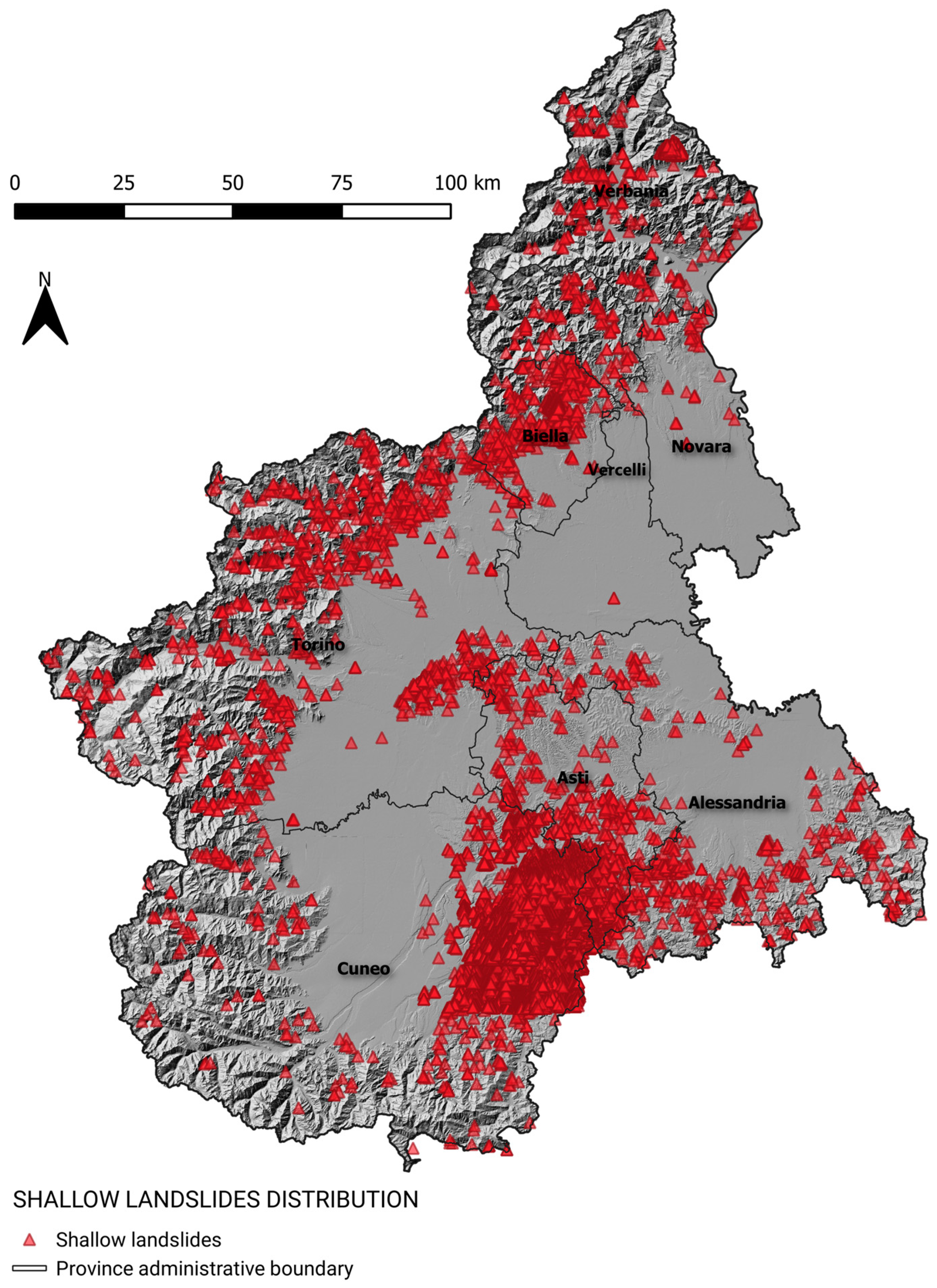
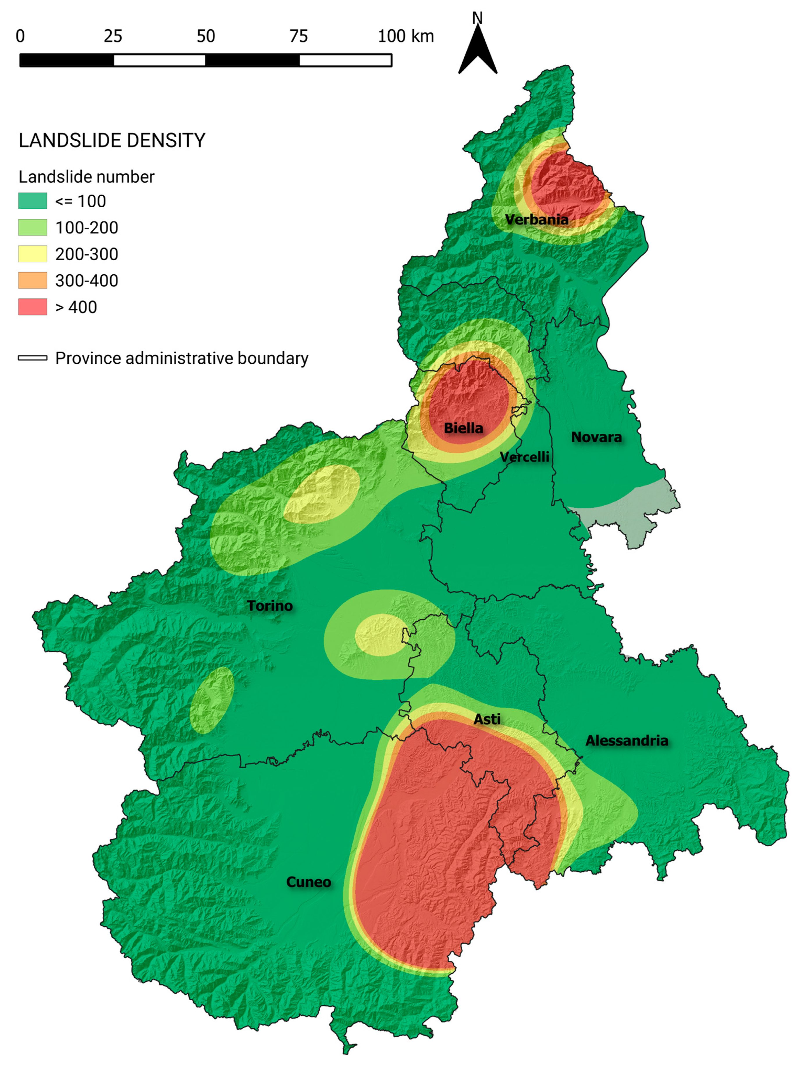
- high-density landslide cluster development. For example, in 1994, a cluster of more than 200 landslides per km² was observed in the Langhe hills (Tertiary Piemonte Basin–TPB–south Piemonte) when an extraordinary rainfall event occurred in November [7].
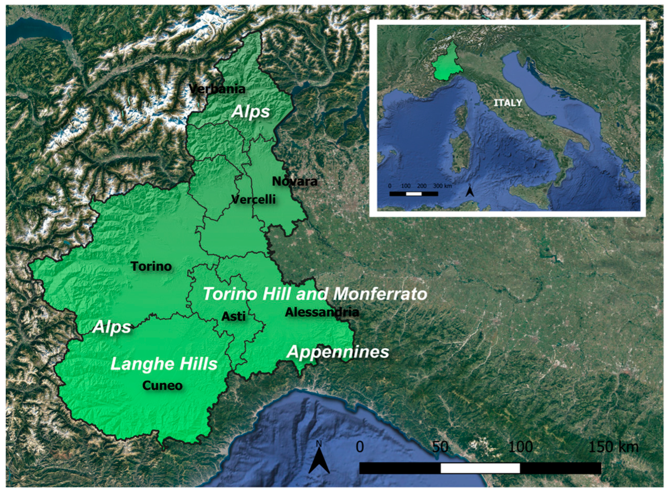
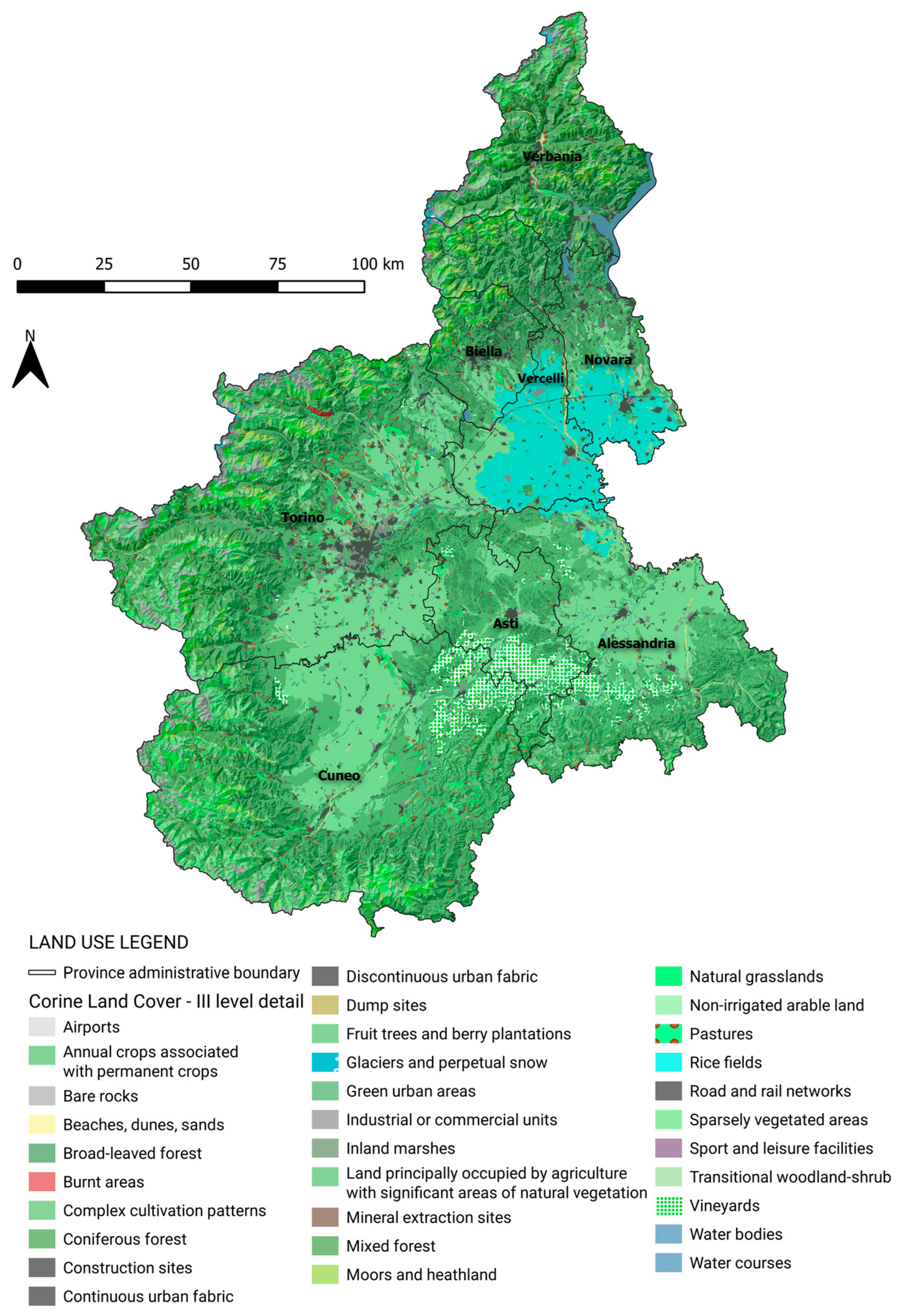
Study Area
2. Materials and Methods
3. Results
- -
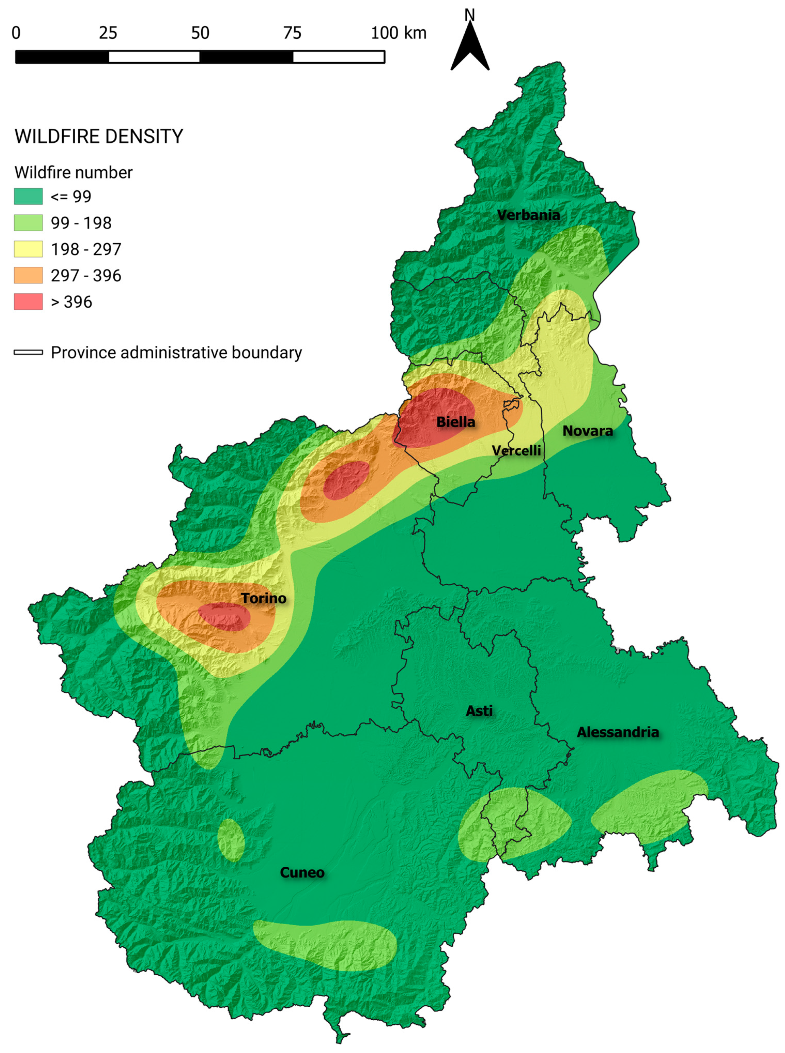
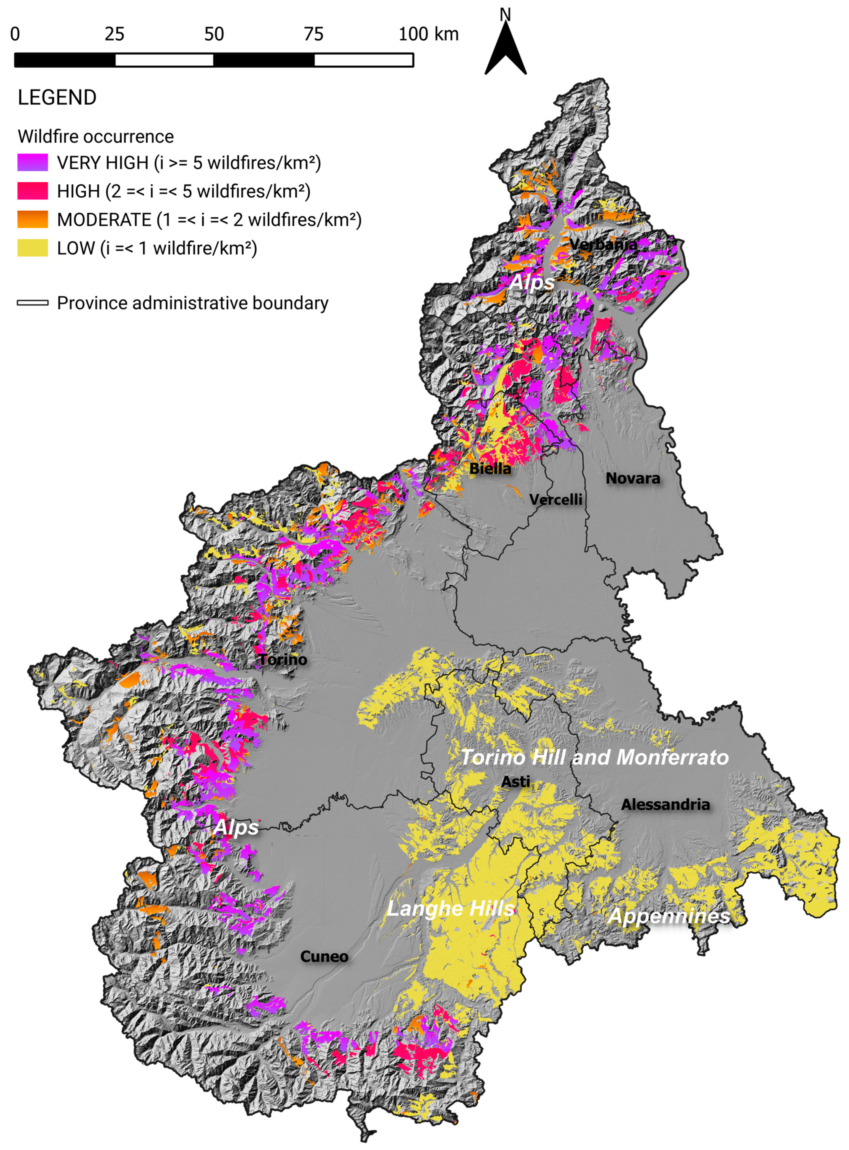
- the density analysis depicts four ranges of wildfire occurrence: from a very high (more than five wildfires per km2) to low occurrence (density lower than one wildfire per km2);
- -
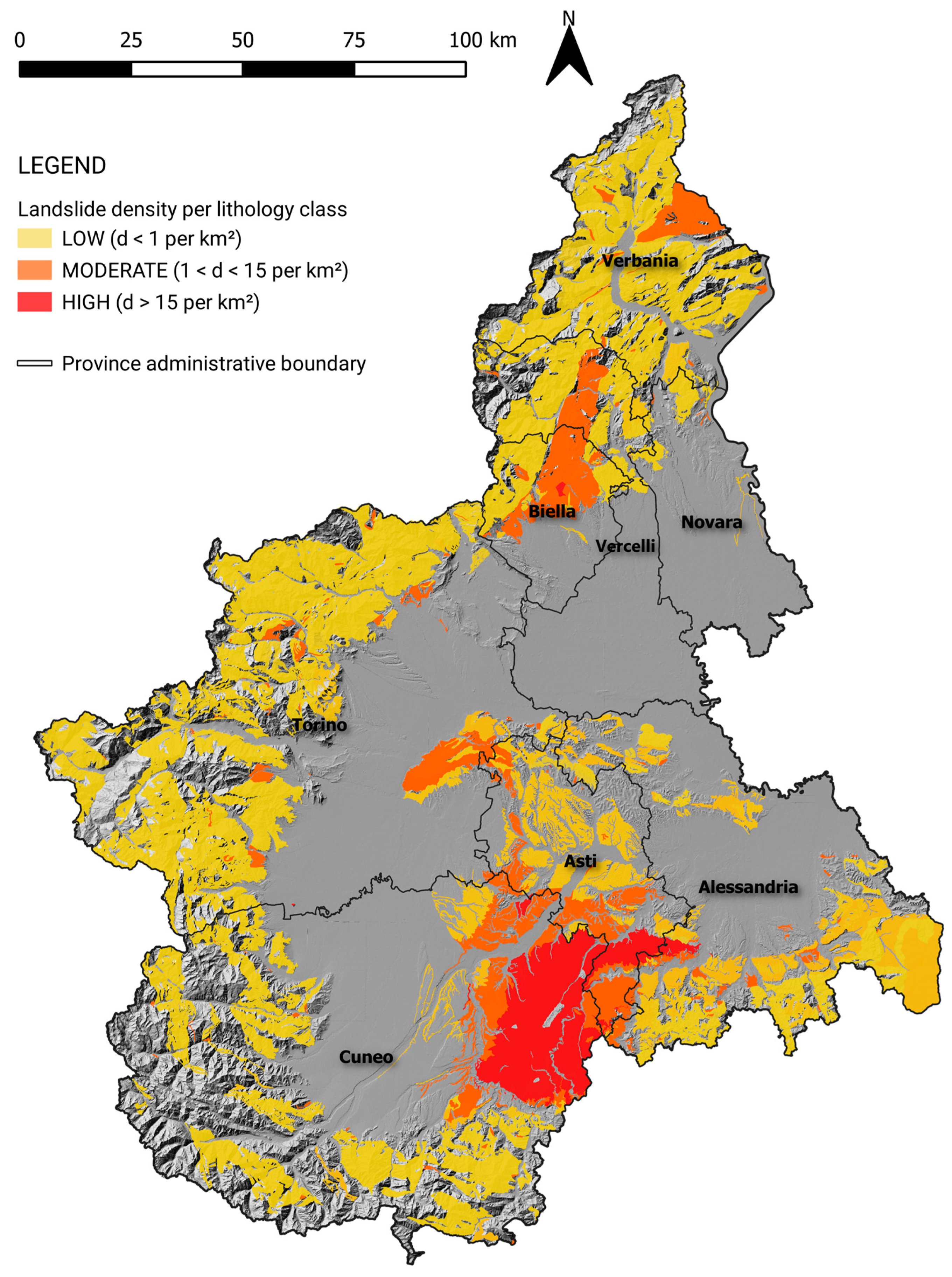
- the overlay of the landslide susceptibility map with the wildfire occurrence map (Figure 12) clarifies the correlation between shallow landslides and wildfires. The correlation does not seem to be significant for the landslide type evaluated in this work. The relationship between wildfire-affected slopes and consequent slope movements is negligible in this regional analysis, but it is important to deepen the analysis to a local scale.
4. Discussion
5. Conclusions
Author Contributions
Funding
Data Availability Statement
Conflicts of Interest
References
- Varnes, D.J. Slope movements, type and processes. In Landslide Analysis and Control; Schuster, R.L., Krizek, R.J., Eds.; Special Report 176; NAS; Washington Transportation Research Board: Washington, DC, USA, 1978. [Google Scholar]
- Zêzere, J.L. Landslide susceptibility assessment considering landslide typology. A case study in the area north of Lisbon (Portugal). Nat. Hazards Earth Syst. Sci. 2002, 2, 73–82. [Google Scholar] [CrossRef]
- Cascini, L. Applicability of landslide susceptibility and hazard zoning at different scales. Eng. Geol. 2008, 102, 164–177. [Google Scholar] [CrossRef]
- Fell, R.F.; Corominas, J.; Bonnard, C.; Cascini, L.; Leroi, E.; Savage, W.Z. JTC-1 Joint Technical Committee on Landslides and Engineered Slopes, Guidelines for landslide susceptibility, hazard and risk zoning for land-use planning. Eng. Geol. 2008, 102, 99–111. [Google Scholar] [CrossRef]
- Borrelli, L.; Ciurleo, M.; Gullà, G. Shallow landslide susceptibility assessment in granitic rocks using GIS-based statistical methods: The contribution of the weathering grade map. Landslides 2018, 15, 1127–1142. [Google Scholar] [CrossRef]
- Cruden, D.M.; Varnes, D.J. Landslides types and processes. In Special Report Landslides: Investigation and Mitigation Transportation Research Board. Natl. Acad. Sci. 1996, 36–75, 1996. [Google Scholar]
- Campus, S.; Nicolò, G.; Rabuffetti, D. Shallow landslides. In Evaluation and Prevention of Natural Risks; Campus, S., Barbero, S., Bovo, S., Forlati, F., Eds.; Taylor & Francis Group: London, UK, 2007; pp. 151–167. ISBN 978-0-415-41386-2. [Google Scholar]
- Aleotti, P. A warning system for rainfall-induced shallow failures. Eng. Geol. 2004, 73, 247–265. [Google Scholar] [CrossRef]
- Aleotti, P.; Baldelli, P.; Polloni, G. Landsliding and flooding event triggered by heavy rains in the Tanaro basin (Italy). Interpraevent 1996, 435–446. [Google Scholar]
- Tiranti, D.; Rabuffetti, D. Estimation of rainfall thresholds triggering shallow landslides for an operational early warning system implementation. Landslides 2010, 7, 471–481. [Google Scholar] [CrossRef]
- Jaedicke, C.; Van Den Eeckhaut, M.; Nadim, F.; Hervàs, J.; Kalsnes, B.; Vidar Vangelsten, B.; Smith, J.T.; Tofani, V.; Ciurean, R.; Winter, M.G.; et al. Identification of landslide hazard and risk ‘hotspots’ in Europe. Bull. Eng. Geol. Environ. 2014, 73, 25–339. [Google Scholar] [CrossRef]
- Segoni, S.; Lagomarsino, D.; Fanti, R.; Moretti, S.; Casagli, N. Integration of rainfall thresholds and susceptibility maps in the Emilia Romagna (Italy) regional-scale landslide warning system. Landslides 2015, 12, 773–785. [Google Scholar] [CrossRef]
- Schmidt, J.; Turek, G.; Clark, M.P.; Uddstorm, M.; Dymond, J.R. Probabilistic forecasting of shallow, rainfall-triggered landslides using real-time numerical weather predictions. Nat. Hazards Earth Syst. Sci. 2008, 8, 349–357. [Google Scholar] [CrossRef]
- Segoni, S.; Leoni, L.; Benedetti, A.I.; Catani, F.; Righini, G.; Falorni, G.; Gabellani, S.; Rudari, R.; Silvestro, F.; Rebora, N. Towards a definition of a real-time forecasting network for rainfall induced shallow landslides. Nat. Hazards Earth Syst. Sci. 2009, 9, 2119–2133. [Google Scholar] [CrossRef]
- Capparelli, G.; Tiranti, D. Application of the MoniFLaIR early warning system for rainfall-induced landslides in the Piedmont region (Italy). Landslides 2010, 7, 401–410. [Google Scholar] [CrossRef]
- Stoffel, M.; Tiranti, D.; Huggel, C. Climate change impacts on mass movements–case studies from the European Alps. Sci. Total Environ. 2014, 493, 1255–1266. [Google Scholar] [CrossRef]
- Tiranti, D.; Nicolò, G.; Gaeta, A.R. Shallow landslides predisposing and triggering factors in developing a regional early warning system. Landslides 2019, 16, 235–251. [Google Scholar] [CrossRef]
- Devoli, G.; Tiranti, D.; Cremonini, R.; Sund, M.; Boje, S. Comparison of landslides forecasting services in Piedmont (Italy) and Norway, illustrated by events in late spring 2013. Nat. Hazards Earth Syst. Sci. 2018, 18, 1351–1372. [Google Scholar] [CrossRef]
- Carabella, C.; Miccadei, E.; Paglia, G.; Sciarra, N. Post-Wildfire Landslide Hazard Assessment: The Case of The 2017 Montagna Del Morrone Fire (Central Apennines, Italy). Geosciences 2019, 9, 175. [Google Scholar] [CrossRef]
- Lainas, S.; Depountis, N.; Sabatakakis, N. Preliminary Forecasting of Rainfall-Induced Shallow Landslides in the Wildfire Burned Areas of Western Greece. Land 2021, 10, 877. [Google Scholar] [CrossRef]
- Kean, J.W.; Staley, D.M. Forecasting the Frequency and Magnitude of Postfire Debris Flows Across Southern California. Earth’s Future 2021, 9, 3. [Google Scholar] [CrossRef]
- Tiranti, D.; Cremonini, R.; Sanmartino, D. Wildfires effect on debris flow occurrence in Italian Western Alps: Preliminary considerations to refine debris flow early warning system criteria. Geosciences 2021, 11, 422. [Google Scholar] [CrossRef]
- Piana, F.; Fioraso, G.; Irace, A.; Mosca, P.; D’Atri, A.; Barale, L.; Falletti, P.; Monegato, G.; Morelli, M.; Tallone, S.; et al. Geology of Piemonte region (NW Italy, Alps–Apennines interference zone). J. Maps 2017, 13, 2017. [Google Scholar] [CrossRef]


| Input Data | Source | Scale | Data Type | Temporal Extent |
|---|---|---|---|---|
| Shallow landslides (ARPA Piemonte landslide database) | Geoportale ARPA Piemonte | Accuracy: maximum 2 m | vector | 1654–2014 |
| Lithology (Geopiemonte) | Geoportale ARPA Piemonte | 1:250,000 | vector | 2017 |
| Pedology (Soil Map) | Geoportale Regione Piemonte | 1:250,000 | vector | 2005 |
| Land use (CLC 2018) | ISPRA | 1:100,000 | vector | 2018 |
| Forest fires | Geoportale Regione Piemonte | Accuracy: maximum 2 m | vector | 1997–2019 |
| Administrative limits | Geoportale Regione Piemonte | 1:10,000 | vector | 2011 |
| Slope environments | Geoportale Regione Piemonte | 1:50,000 | vector | 2017 |
| DTM | Geoportale Regione Piemonte | 1:10,000 | raster | 2008 |
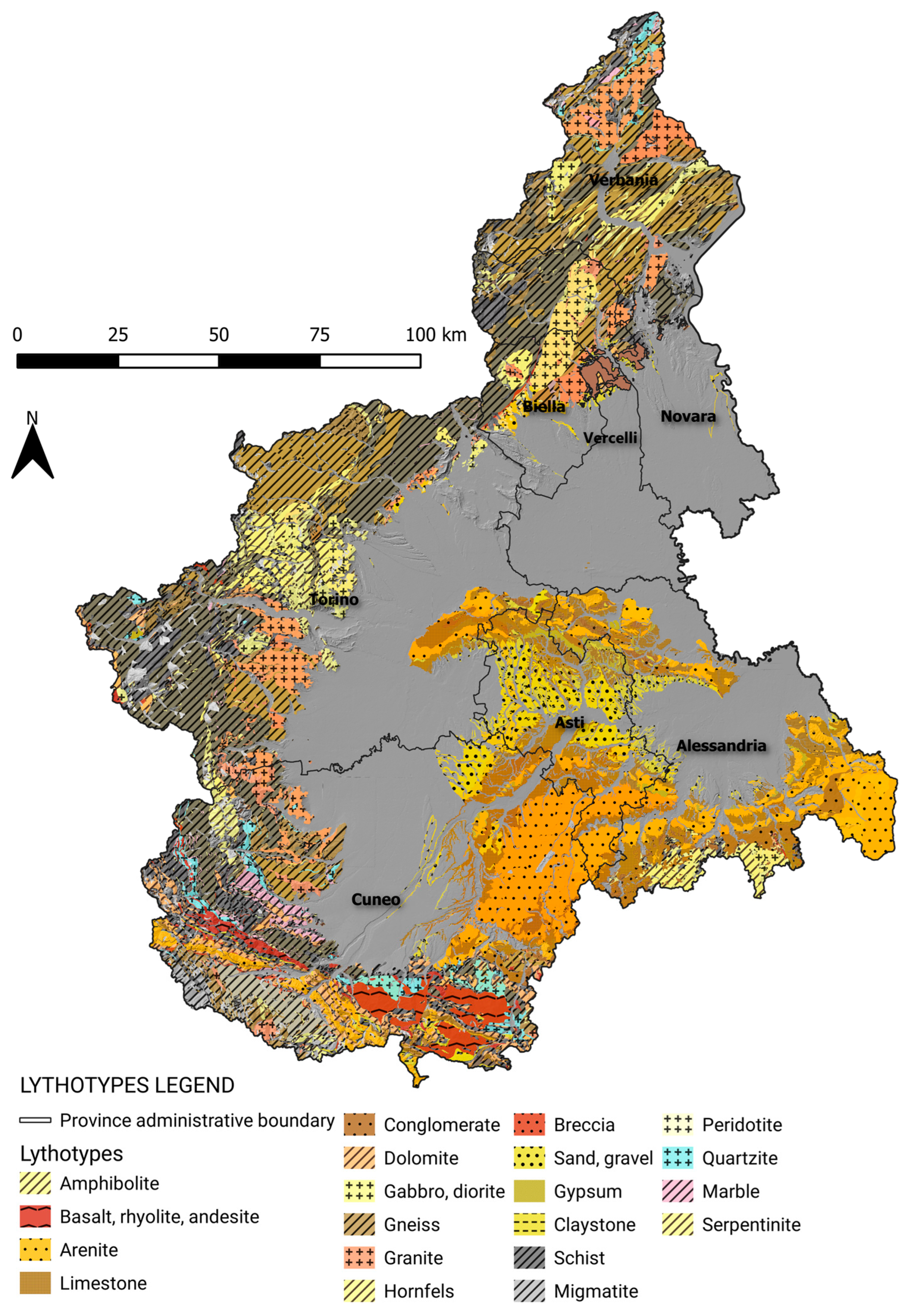
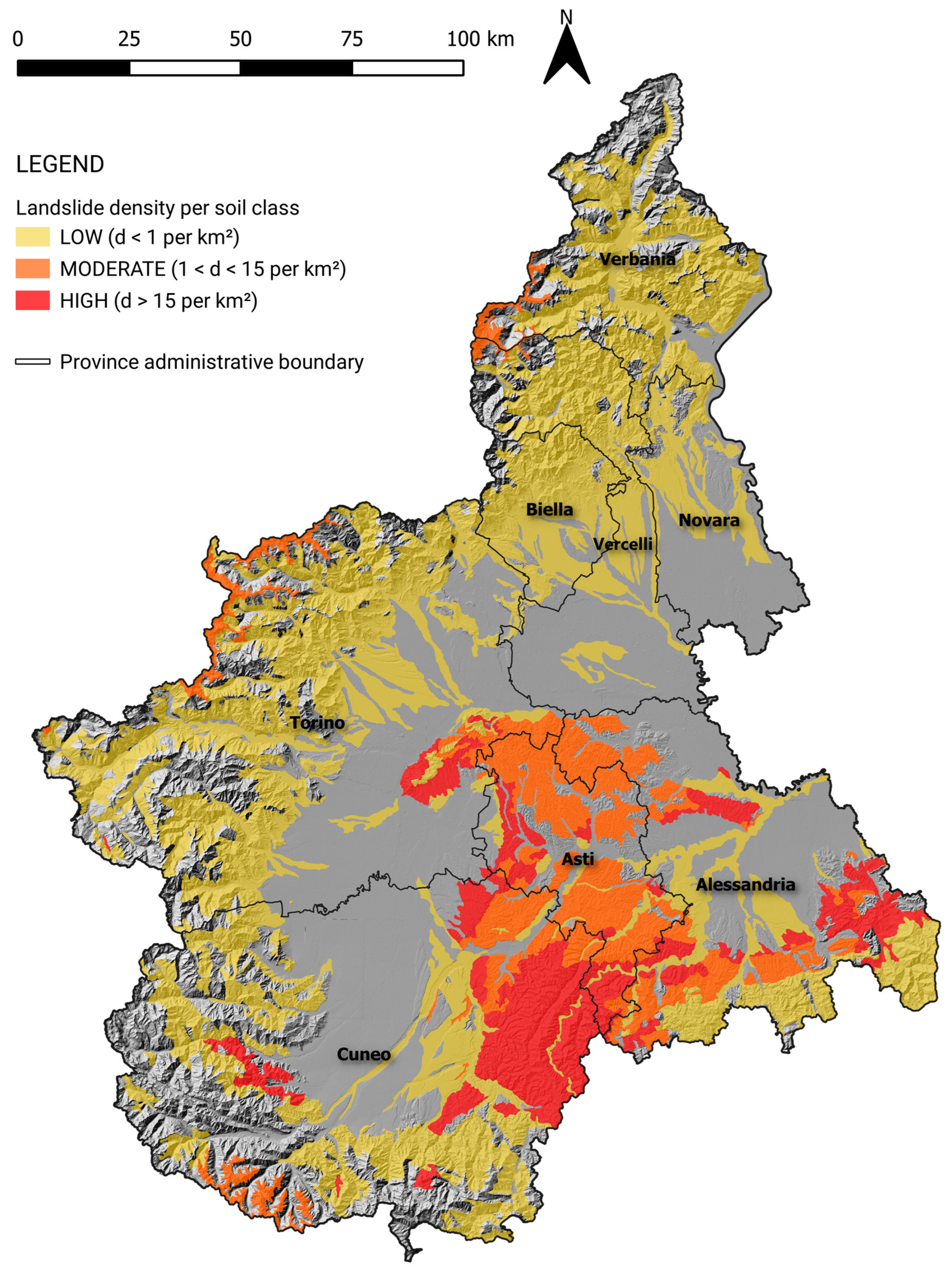
| Lithotype | Area (km²) | Landslides n° | Density (Landslides/km²) | Density Class |
|---|---|---|---|---|
| Arenite | 1531.13 | 26351 | 17.21 | HIGH (d ≥ 15 landslides/km²) |
| Limestone | 913.4 | 4916 | 5.38 | MODERATE (2 ≤ d ≤ 15 landslides/km²) |
| Marble | 13.18 | 18 | 1.37 | |
| Peridotite | 129.34 | 151 | 1.17 | |
| Granite | 728.37 | 843 | 1.16 | |
| Gabbro, diorite | 292.62 | 303 | 1.04 | |
| Sand, gravel | 549.53 | 559 | 1.02 | |
| Gypsum | 53.98 | 46 | 0.85 | LOW (d ≤ 2 landslides/km²) |
| Breccia | 1.39 | 1 | 0.72 | |
| Dolomite | 58.66 | 35 | 0.60 | |
| Migmatite | 180.28 | 109 | 0.60 | |
| Hornfels | 26.44 | 12 | 0.45 | |
| Conglomerate | 212.73 | 78 | 0.37 | |
| Schist | 2255.40 | 596 | 0.26 | |
| Quartzite | 86.17 | 22 | 0.26 | |
| Gneiss | 1481.96 | 373 | 0.25 | |
| Serpentinite | 353.09 | 90 | 0.25 | |
| Claystone | 25.15 | 6 | 0.24 | |
| Vulcanite | 92.45 | 17 | 0.18 | |
| Amphibolite | 50.85 | 6 | 0.12 | |
| Basalt, rhyolite, andesite | 280.36 | 25 | 0.09 |
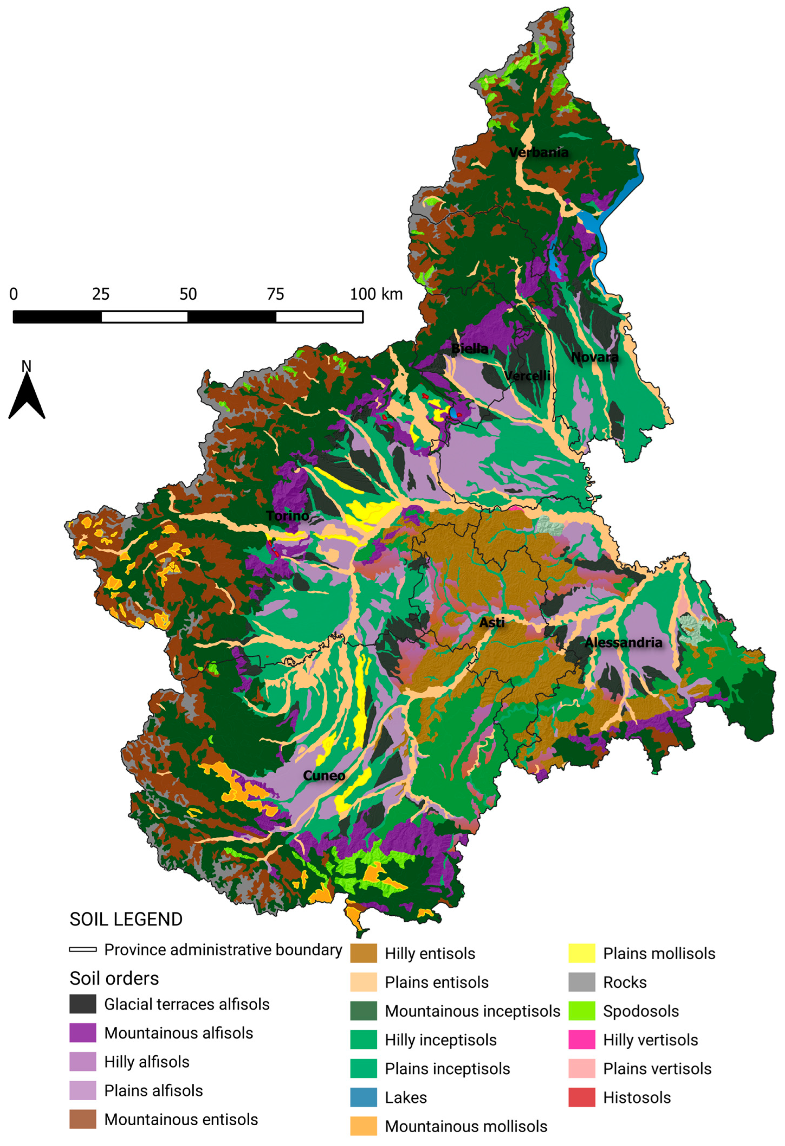
| Soil Type | Area (km²) | Landslides n° | Density (landslides/km²) | Density Class |
|---|---|---|---|---|
| Hilly inceptisols | 1167.55 | 24273 | 20.79 | HIGH (d ≥ 15 landslides/km²) |
| Hilly alfisols | 534.45 | 4708 | 8.81 | MODERATE (2 ≤ d ≤ 15 landslides/km²) |
| Hilly entisols | 1802.48 | 2696 | 1.50 | |
| Plains entisols | 785.82 | 671 | 0.85 | LOW (d≤ 2 landslides/km²) |
| Mountainous entisols | 948.12 | 806 | 0.85 | |
| Mountainous alfisols | 1191.14 | 758 | 0.64 | |
| Plains alfisols | 495.95 | 293 | 0.59 | |
| Mountainous inceptisols | 4264.46 | 1430 | 0.34 | |
| Glacial terraces alfisols | 846.55 | 277 | 0.33 | |
| Plains inceptisols | 664.50 | 182 | 0.27 | |
| Lakes | 17.98 | 3 | 0.17 | |
| Spodosols | 127.20 | 17 | 0.13 | |
| Mountainous mollisols | 116.06 | 8 | 0.07 | |
| Rocks | 369.39 | 7 | 0.02 |
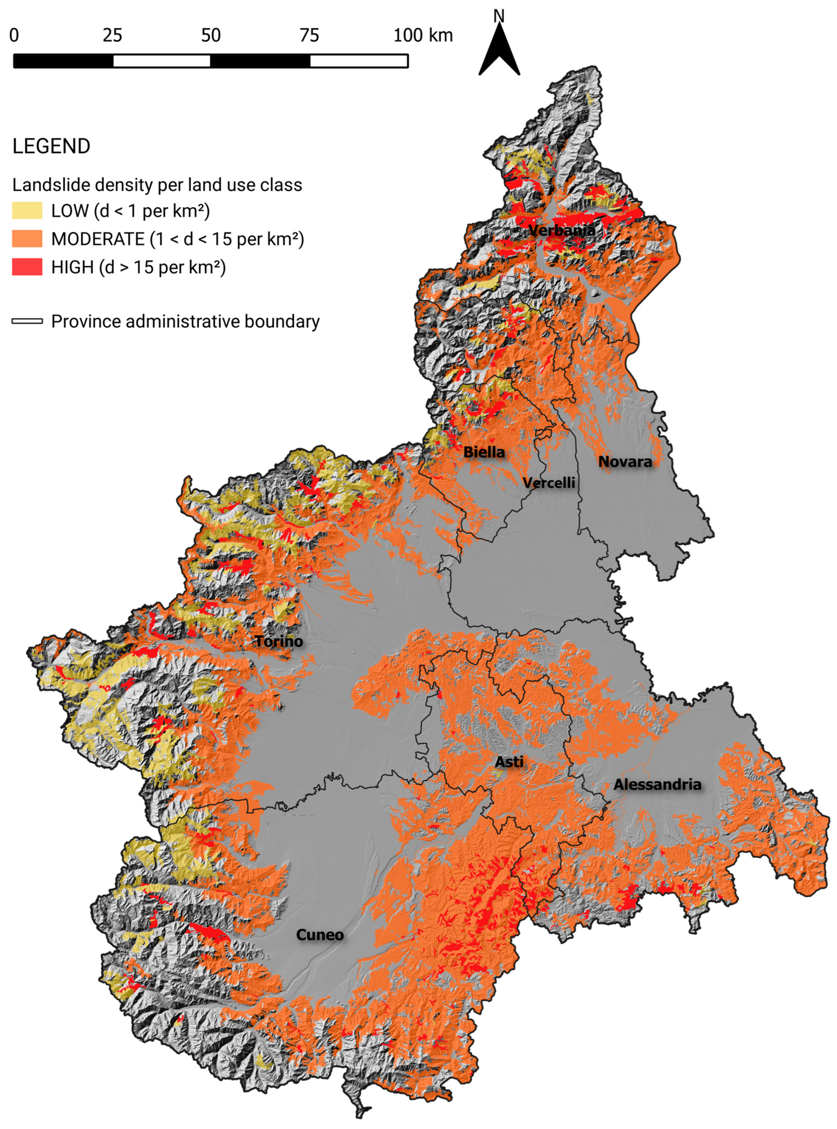
| Land Use | Area (km²) | Landslides n° | Density (Landslides per km²) | Density Class |
|---|---|---|---|---|
| Pastures | 76.488 | 2050 | 26.80 | HIGH (d ≥ 15 landslides/km²) |
| Transitional woodland/shrubs | 183.553 | 2238 | 12.19 | |
| Mixed forest | 457.973 | 4735 | 10.34 | MODERATE (2 ≤ d ≤ 15 landslides/km²) |
| Land principally occupied by agriculture, with significant areas of natural vegetation | 1150.38 | 11,443 | 9.95 | |
| Mineral extraction sites | 0.251 | 2 | 7.97 | |
| Vineyards | 536.882 | 3475 | 6.47 | |
| Fruit trees and berry plantation | 42.268 | 264 | 6.25 | |
| Industrial or commercial units | 3.671 | 15 | 4.09 | |
| Discontinuous urban fabric | 200.829 | 535 | 2.66 | |
| Complex cultivation patterns | 970.898 | 2119 | 2.18 | |
| Broad-leaved forest | 4535.448 | 8699 | 1.92 | |
| Continuous urban fabric | 2.809 | 4 | 1.42 | |
| Water courses | 28.99 | 32 | 1.10 | |
| Natural grassland | 176.663 | 129 | 0.73 | LOW (d ≤ 2 landslides/km²) |
| Moors and heathland | 56.784 | 39 | 0.69 | |
| Burnt areas | 9.973 | 6 | 0.60 | |
| Coniferous forest | 327.019 | 160 | 0.49 | |
| Annual crops associated with permanent crops | 2.749 | 1 | 0.36 | |
| Sparsely vegetated areas | 670.316 | 101 | 0.15 | |
| Non-irrigated arable land | 2040.379 | 96 | 0.05 | |
| Water bodies | 113.431 | 4 | 0.04 | |
| Bare rock | 180.904 | 4 | 0.02 |
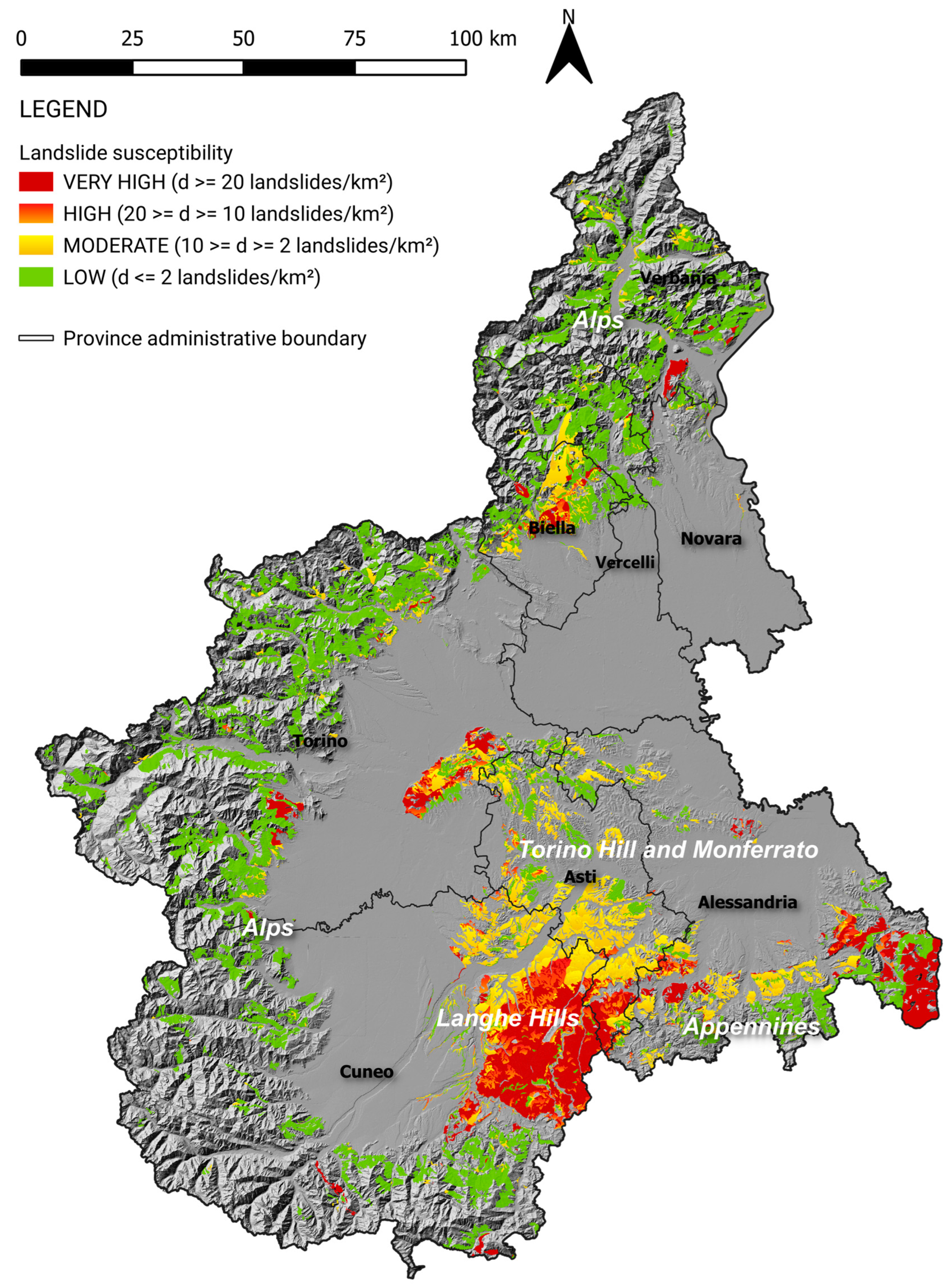
| Landslide Susceptibility | Density (Landslides/km²) |
|---|---|
| Very high | d ≥ 20 landslide points/km² |
| High | 10 ≤ d ≤ 20 landslide points/km² |
| Moderate | 2 ≤ d ≤ 10 landslide points/km² |
| Low | d ≤ 2 landslide points/km² |
| Sum of Higher Predisposing Factors (Alpine Environments) | Area (km2) | Landslides n° | Landslide Density | Susceptibility Class |
|---|---|---|---|---|
| Artificial surfaces; vulcanite; alfisols | 0.02 | 1 | 50.00 | HIGH (d > 20 landslides per km2) |
| Pastures; granite; entisols | 0.11 | 5 | 45.45 | |
| Pastures; basalt, rhyolite, andesite; afisols | 0.03 | 1 | 33.33 | |
| Transitional woodland/shrubs; granite; entisols | 9.07 | 292 | 32.19 | |
| Pastures; serpentinite; entisols | 0.04 | 1 | 25,00 | |
| Forest; granite; entisols | 9.18 | 193 | 21.02 | |
| Sparsely vegetated areas; quartzite; entisols | 0.2 | 4 | 20.00 |
| Sum of Higher Predisposing Factors (Hilly/Apennines Environments) | Area (km2) | Landslides n° | Landslide Density | Susceptibility Class |
|---|---|---|---|---|
| Artificial surfaces; limestone; inceptisols | 0.04 | 6 | 150.00 | HIGH (d> 20 landslides per km2) |
| Forest; arenite; entisols | 0.51 | 69 | 135.29 | |
| Transitional woodland/shrubs; arenite; inceptisols | 9.18 | 1130 | 123.09 | |
| Transitional woodland/shrubs; limestone; inceptisols | 2.92 | 358 | 122.60 | |
| Transitional woodland/shrubs; arenite; entisols | 2.07 | 225 | 108.70 | |
| Artificial surfaces; limestone; alfisols | 0.16 | 17 | 106.25 | |
| Forest; limestone; inceptisols | 0.03 | 3 | 100.00 | |
| Transitional woodland/shrubs; limestone; inceptisols | 0.22 | 21 | 95.45 | |
| Pastures; arenite; entisols | 2.14 | 167 | 78.04 | |
| Artificial surfaces; arenite; alfisols | 0.09 | 7 | 77.78 |
Disclaimer/Publisher’s Note: The statements, opinions and data contained in all publications are solely those of the individual author(s) and contributor(s) and not of MDPI and/or the editor(s). MDPI and/or the editor(s) disclaim responsibility for any injury to people or property resulting from any ideas, methods, instructions or products referred to in the content. |
© 2023 by the authors. Licensee MDPI, Basel, Switzerland. This article is an open access article distributed under the terms and conditions of the Creative Commons Attribution (CC BY) license (https://creativecommons.org/licenses/by/4.0/).
Share and Cite
Fedato, E.; Fubelli, G.; Kurilla, L.; Tiranti, D. Predisposing Factors for Shallow Landslides in Alpine and Hilly/Apennines Environments: A Case Study from Piemonte, Italy. Geosciences 2023, 13, 252. https://doi.org/10.3390/geosciences13080252
Fedato E, Fubelli G, Kurilla L, Tiranti D. Predisposing Factors for Shallow Landslides in Alpine and Hilly/Apennines Environments: A Case Study from Piemonte, Italy. Geosciences. 2023; 13(8):252. https://doi.org/10.3390/geosciences13080252
Chicago/Turabian StyleFedato, Eva, Giandomenico Fubelli, Laurie Kurilla, and Davide Tiranti. 2023. "Predisposing Factors for Shallow Landslides in Alpine and Hilly/Apennines Environments: A Case Study from Piemonte, Italy" Geosciences 13, no. 8: 252. https://doi.org/10.3390/geosciences13080252