

Classification of Risks for Landslides in Slopes and Hillsides of Volcanic Nature in Macaronesia and Their Application to the Canary Islands


Abstract
:1. Introduction
- Geomorphological factors: The spatial relationship between the slope and the planes of discontinuity of the soil masses or rock masses determines the stability conditions of these planes and defines the possibility of movements [3]. The erosion or undermining of the foot of slopes, escarpments and cliffs by river, coastal or other types of erosion leads to a loss of resistance in the area [4] and to modification of the state of tension. Together with the lack of support from the overlying material, this can cause instability and the generation of slides or landslides.
- Geological factors: Lithology and stratigraphy are related to the type of instability potentially expected, with different lithologies having different degrees of potential susceptibility to the occurrence of landslides or ruptures. The physical and resistance properties of each type of material, together with the presence of water, govern its mechanical behaviour [5]. Aspects such as the alternation of different materials, competition and degree of alternation, or the presence of layers of soft material control the types and dispositions of the breaking surfaces, which tend to be oriented by the upper areas of altered rock or by areas of more or less homogeneous soils. In rocky massifs, the existence of layers or strata of unequal competition can give rise to instabilities in terms of the movement of the slope related to differences in both the erosive characteristics and the speed of erosion, further complicating the characterization and behaviour of the slope.
- Hydrogeological factors: Groundwater control is an effective system for the stabilization of deep slides of great magnitude whose triggering is not related to seasonal meteorological phenomena but rather to long-term climatic conditions, because rainfall regimes and humidity conditions are capable of substantially modifying the phreatic levels and water content of the land [6].
- Meteorological phenomena: the risk of landslides or rock falls on slopes is greatly increased when adverse meteorological phenomena occur, such as storms, squalls and sea storms that bring high levels of precipitation, waves to the coast and gusts of wind that can unbalance the forces acting on the slopes, causing their destabilization. However, we consider rain to be the factor that most influences the loss of balance in slopes because most of these events occur after intense rain or during rainy periods [9].
- Seismicity: earthquakes can cause all kinds of movements on slopes and embankments [10], depending on both the characteristics and properties of the materials and the magnitude of the earthquake as well as the distance to the epicentre and hypocentre 1).
2. Materials and Methods
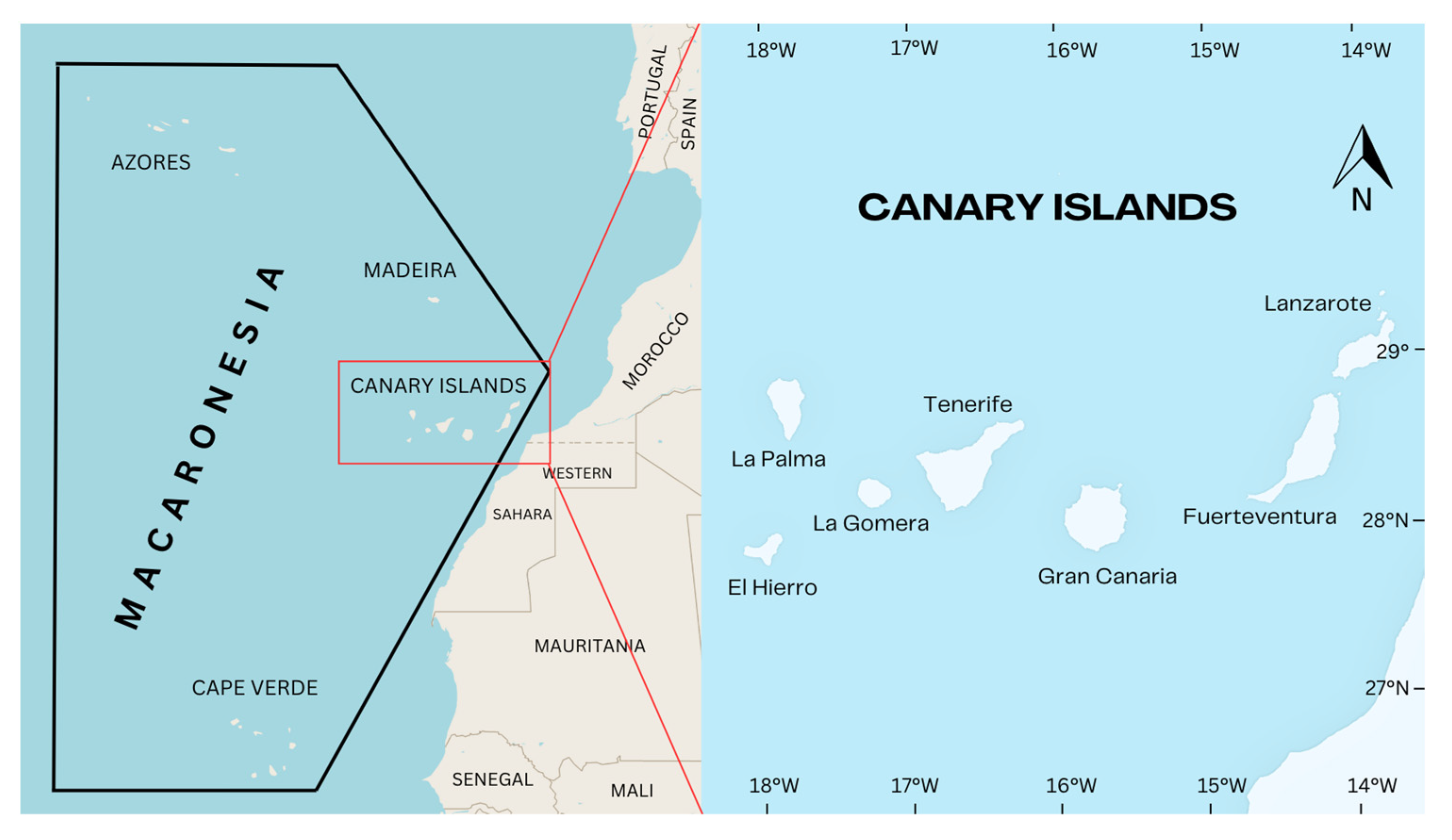
2.1. Study Area
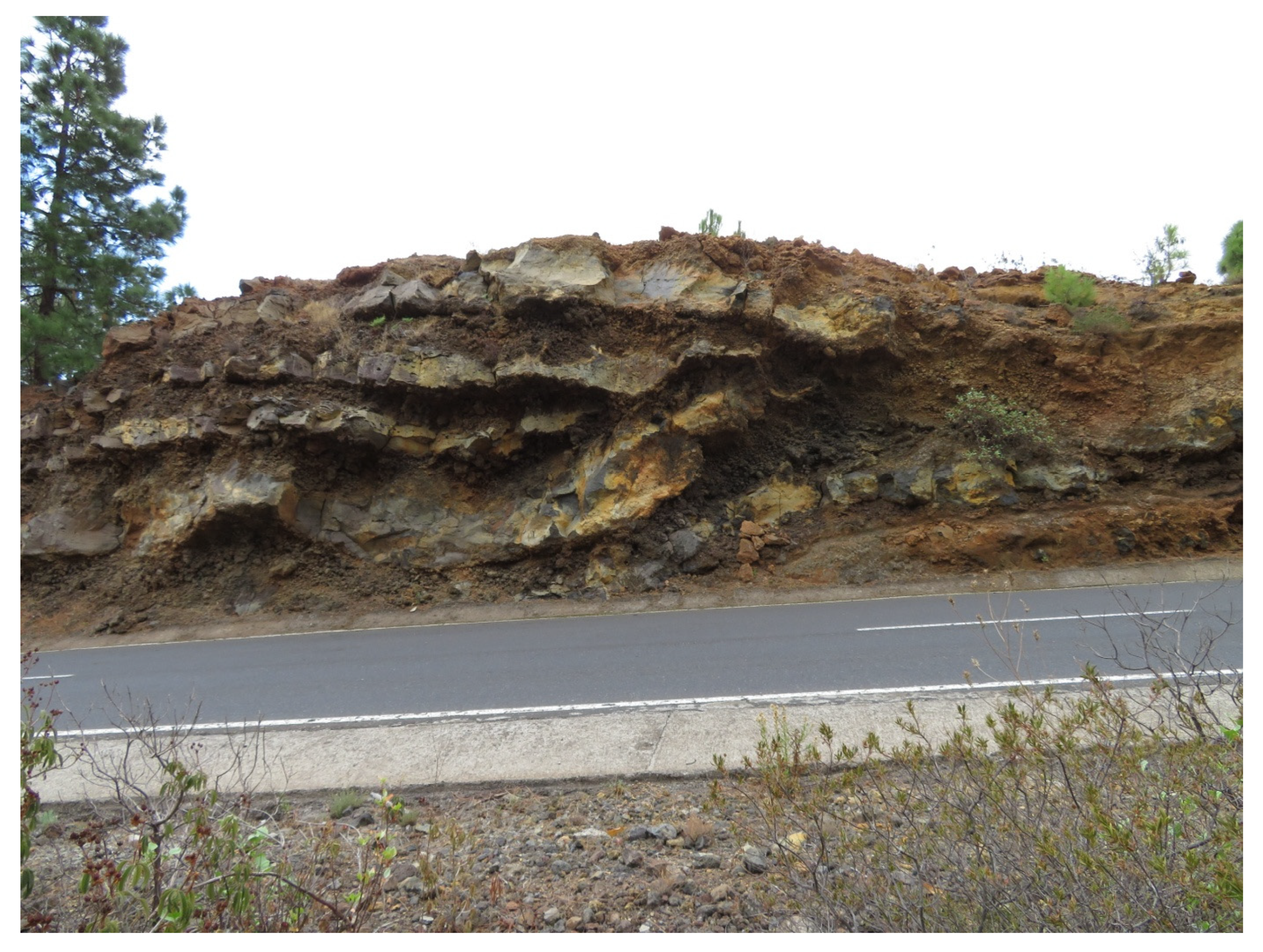
- Type A slopes are those in which hard rocks predominate, such as basalt and salt casts (trachytes, phonolites and rhyolites) or compact pyroclasts, such as welded tuff or ignimbrites. Therefore, the lithotypes corresponding to Geotechnical Units II, III, IVa and Va would be included in this typology, according to GETCAN-011 [19]. The behaviour of this type of slope is strongly conditioned by the presence of discontinuities in the rock and its orientation or spatial arrangement. The characteristics of the joints (persistence, roughness and opening) and the presence of holes and altered areas also condition their stability. The most frequent mechanism of breakage or instability is associated with this degree of fracture and its orientation with respect to the face of the slope, giving rise to local or partial fractures of the planar, wedge-shaped, overturning or chinning type and/or small detachments limited to the most superficial level of the slope.
- Type B slopes: These are solid or made up of deposits of pyroclastic materials, both basaltic and salic, loose or weakly welded or cemented (known as picón or pumice). Therefore, the lithotypes corresponding to the Va (tuff) and Vb geotechnical units would be included in this typology. The most common instabilities in this type of slope are due to chinning or falls of small-sized edges, although the presence of larger pumps wrapped in their matrix can mean a greater risk when these are left uncovered and without support due to processes of differential erosion. Eventually, on slopes with a strong inclination and with little or no degree of welding or cementing, mass movement processes (rotational slides) may be triggered.
- Type C slopes: These are massifs formed by sequences of materials of different competences and/or resistances, for example, alternations between compact levels of lava and levels of slag or pyroclast that erode at different rates. This would fundamentally affect Geotechnical Units IV and V and could also occur in Units II and III when they alternate on the slope with other units from other eruptive episodes. The behaviour of this type of slope is strongly conditioned by the differences in the erosive characteristics and the speed of erosion of the different strata it contains. The most frequent mechanism of breakage or instability is associated with the fall of blocks due to the removal of the base or loss of support of the most resistant levels (basaltic and saline casts), caused by the formation of visors or cornices due to greater erosion at the less competent levels.
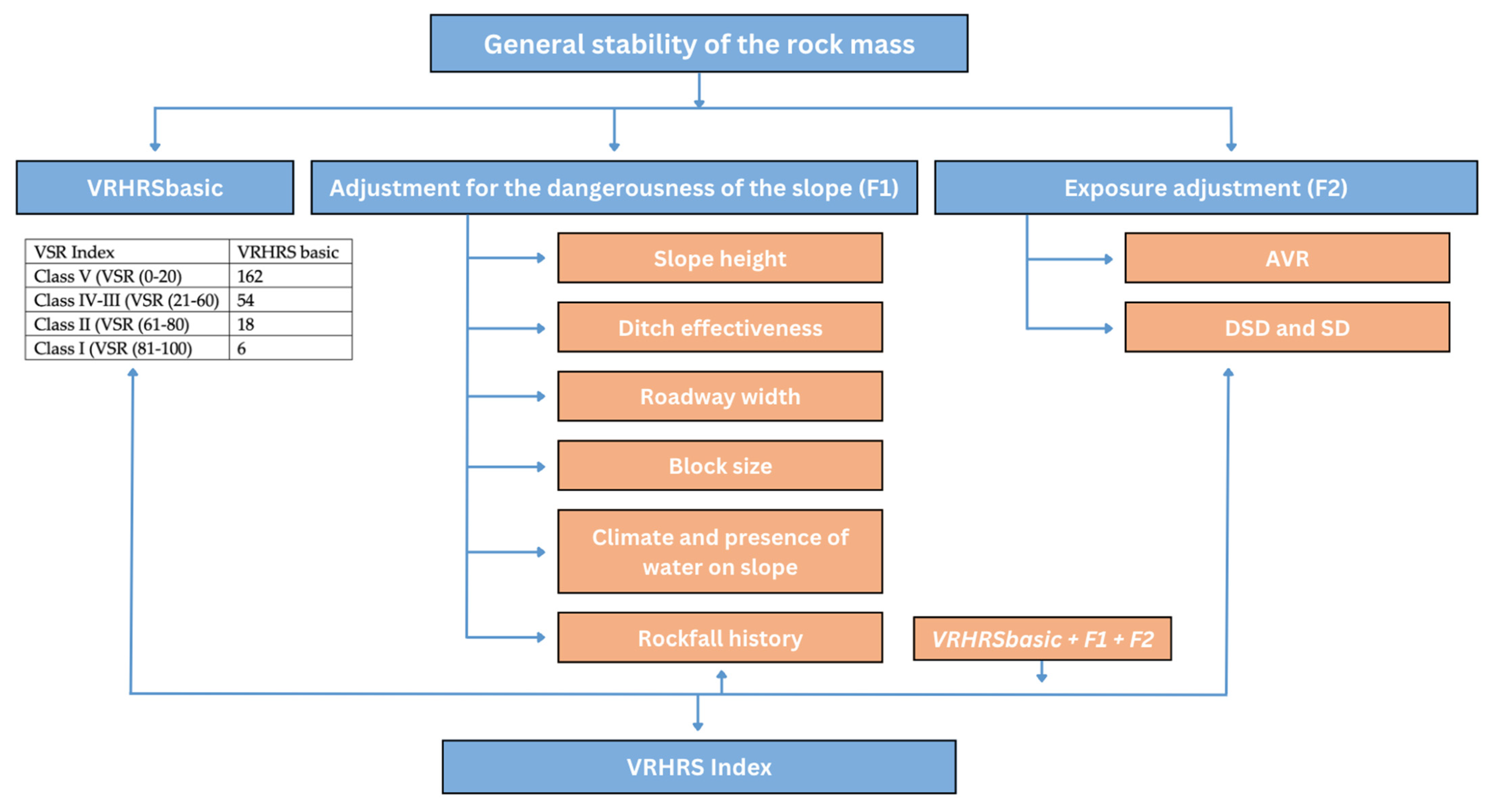
2.2. VRHRS Classification
3. Results and Discussion
- Slope height: The blocks of rock that fall from a greater height have greater potential energy than those that fall from a lower height [23]; thus, the former represents a greater risk and will receive a higher score. The height will be measured from the highest point of the slope from which the rocks can fall. If the possibility of falling rocks from any area of the natural slope located above the clearing slope of the road is detected, this will be considered for the purposes of the vertical height.
- Ditch effectiveness: The effectiveness of a ditch is measured by its ability to limit the amount of stone that is removed from the road. Depending on the slope of the embankment, there can be four types of trajectories of the rocks during their fall: free falling, bouncing, rolling, and sliding. To estimate the effectiveness of a ditch, the assessor should consider the height and angle of the slope; the width, depth, and shape of the ditch; the size of the block that can be detached; and the irregularities present (berms, projections, visors, cavities, etc.) that may have a possible effect on the trajectory.
- Roadway width: This dimension, measured transversely to the axis of the track, represents the margin of manoeuvre available to the user to avoid impact with a possible rock fall. This measure should be the minimum width when the roadway width is not constant. The width of the hard shoulder shall be considered only if it is paved.
- Block size: This parameter represents the phenomenon of the most likely detachment [24]. If individual blocks are involved, the score will depend on the size of the blocks. However, if the fall of a fractured rock mass is expected, the volume of the fracture is what is valued. The decision regarding which to use should be determined, where possible, from the fall or landslide history available to the Road Maintenance Service or Department.
- Climate and presence of water on the slope: Water and ice/thaw cycles contribute to wear or weathering and sliding of rocky materials. If water is known to flow continuously or intermittently down the slope, this factor can be weighted accordingly. The impact of the ice/thaw cycle can be interpreted from the freezing conditions and their effects on the area. To facilitate the work of the evaluator, four climate zones were established for the Canary Islands, as a result of the CLIMCAN-010 study [25].
- CZ1: Slopes or hillsides located in areas of low precipitation, <300 mm/year. These are characterized by low to moderate precipitation, without periods of frost or water on the slope.
- CZ2: Slopes or hillsides located in areas of moderate precipitation at an elevation below 2000 m a.s.l., 300–500 mm/year. The area is characterized by moderate precipitation or with short periods of frost, or where the presence of water is intermittently detected on the slope is.
- CZ3: Slopes or hillsides located in areas of moderate precipitation at or above 2000 m a.s.l. or slopes or hillsides located in areas of high precipitation, 501–1000 mm/year. The area is characterized by high precipitation or long periods of frost, or where there is a continuous presence or upwelling of water on the slope.
- CZ4: Slopes or hillsides located in areas of very high precipitation, 1001–2000 mm/year. These are characterized by high precipitation and long periods of frost or by the continuous presence of water on the slope and long periods of frost.
- Rockfall history: This is a parameter that considers past landslides as an indicator of potential future events. It is essential to have this historical information, as far as possible, which should be based on the reports of the road conservation or maintenance teams attached to the slope or rock massif under study. In areas of recent construction or where no information or documented records of previous events are available, the assessment will be made on the basis of similarity with other slopes, indicating the convenience of revising this assessment in the future as more information becomes available.
- Average vehicle risk (AVR): This parameter measures the risk associated with time in percentage of vehicles on the road section with the possibility of landslides. Its value can be obtained by means of the following equation, based on the length of the section (in front of the study slope), the average daily vehicle intensity (AVD) and the speed limitations established therein:
- Decision sight distance (DSD): length or distance required to have a driver stop their vehicle when making a complex or unpredictable decision, such as when there is an unexpected obstacle (e.g., a rock in the road) in their path [26]. The recommended values for this parameter as a function of speed can be found in Table 5.
4. Conclusions
Author Contributions
Funding
Data Availability Statement
Acknowledgments
Conflicts of Interest
References
- Highland, L.M.; Bobrowsky, P. The Landslide Handbook—A Guide to Understanding Landslides; Circular 1325; Geological Survey: Reston, VA, USA, 2008; 129p. [Google Scholar]
- Kovrov, O.; Kolesnyk, V. Development of the landslide hazard control system of natural and man-made slopes. Technol. Audit. Prod. Reserves 2018, 6, 21–25. [Google Scholar] [CrossRef]
- Jia, N.; Mitani, Y.; Xie, M.; Djamaluddin, I. Shallow landslide hazard assessment using a three-dimensional deterministic model in a mountainous area. Comput. Geotech. 2012, 45, 1–10. [Google Scholar] [CrossRef]
- Chen, Y.C.; Chang, K.T.; Chiu, Y.J.; Lau, S.M.; Lee, H.Y. Quantifying rainfall controls on catchment-scale landslide erosion in Taiwan. Earth Surf. Process. Landf. 2013, 38, 372–382. [Google Scholar] [CrossRef]
- Safaei, M.; Omar, H.; Huat, B.K.; Yousof, Z.B.M. Relationship between lithology factor and landslide occurrence based on information value (IV) and frequency ratio (FR) approaches—Case study in north of Iran. Electron. J. Geotech. Eng. 2012, 17, 79–90. [Google Scholar]
- Zhao, Y.; Li, Y.; Zhang, L.; Wang, Q. Groundwater level prediction of landslide based on classification and regression tree. Geod. Geodyn. 2016, 7, 348–355. [Google Scholar] [CrossRef]
- Namdar, A.; Yahaya, F.M. Effect of natural hazards on types of landslide. Electron. J. Geotech. Eng. 2014, 19, 1519–1532. [Google Scholar]
- Zhao, B.; Dai, Q.; Han, D.; Dai, H.; Mao, J.; Zhuo, L. Probabilistic thresholds for landslides warning by integrating soil moisture conditions with rainfall thresholds. J. Hydrol. 2019, 574, 276–287. [Google Scholar] [CrossRef]
- Vessia, G.; Di Curzio, D.; Chiaudani, A.; Rusi, S. Regional rainfall threshold maps drawn through multivariate geostatistical techniques for shallow landslide hazard zonation. Sci. Total Environ. 2020, 705, 135815. [Google Scholar] [CrossRef] [PubMed]
- Wang, Y.; Rathje, E.M. Probabilistic seismic landslide hazard maps including epistemic uncertainty. Eng. Geol. 2015, 196, 313–324. [Google Scholar] [CrossRef]
- Budetta, P. The modified “Rockfall Hazard Rating System”: A new tool for roads risk Assessment of rockfall risk along roads. Nat. Hazards Earth Syst. Sci. 2003, 4, 71–81. [Google Scholar] [CrossRef]
- Bieniawski, Z.T. Engineering Rock Mass Classifications: A Complete Manual for Engineers and Geologists in Mining, Civil and Petroleum Engineering; John Wiley & Sons: Hoboken, NJ, USA, 1989. [Google Scholar]
- Barton, N.; Lien, R.; Lunde, J. Engineering classification of rock masses for the design of tunnel support. Rock Mech. 1974, 6, 189–236. [Google Scholar] [CrossRef]
- González de Vallejo, L.I.; Hernández Gutiérrez, L.E.; Miranda, A.; Ferrer, M. Rockfall Hazard Assessment in Volcanic Regions Based on ISVS and IRVS Geomechanical Indices. Geosciences 2020, 10, 220. [Google Scholar] [CrossRef]
- Rodríguez-Losada, J.A.; Hernández-Gutiérrez, L.E.; Olalla, C.; Perucho, A.; Serrano, A.; Eff-Darwich, A. Geomechanical parameters of intact rocks and rock masses from the Canary Islands: Implications on their flank stability. J. Volcanol. Geotherm. Res. 2009, 182, 67–75. [Google Scholar] [CrossRef]
- Steiner, C.; Hobson, A.; Favre, P.; Stampfli, G.M.; Hernandez, J. Mesozoic sequence of Fuerteventura (Canary Islands): Witness of Early Jurassic sea-floor spreading in the central Atlantic. GSA Bull. 1998, 110, 1304–1317. [Google Scholar] [CrossRef]
- Pérez, N.M.; Padilla, G.D.; Padrón, E.; Hernández, P.A.; Melián, G.V.; Barrancos, J.; Dionis, S.; Nolasco, D.; Rodríguez, F.; Calvo, D.; et al. Precursory diffuse CO2 and H2S emission signatures of the 2011-2012 El Hierro submarine eruption, Canary Islands. Geophys. Res. Lett. 2012, 39, 6–10. [Google Scholar] [CrossRef]
- Fernandez-Hernández, M.; Paredes, C.; Castedo, R.; Llorente, M.; de la Vega-Panizo, R. Rockfall detachment susceptibility map in El Hierro Island, Canary Islands, Spain. Nat. Hazards 2012, 64, 1247–1271. [Google Scholar] [CrossRef]
- Gobierno de Canarias. Guía para la planificación y realización de estudios geotécnicos para la edificación en la Comunidad Autónoma de Canarias. GETCAN 011 2010, 1, 53. [Google Scholar]
- Pierson, L.A.; Davis, S.A.; Van Vickle, R. Rockfall Hazard Rating System Implementation Manual; Federal Highway Administration, US Department of Transportation: Washington, DC, USA, 1990; p. 80. [Google Scholar]
- Franklin, J.A.; Senior, S.A. RHRON—The Ontario rockfall hazard rating system. In Proceedings of the IAEG International Association for Engineering Geology and the Environment, Athens, Greece, 1997. [Google Scholar]
- Muñiz Menéndez, M.; González-Gallego, J. A simple methodology for hazard assessment of slopes in volcanic rocks from the Canary Islands: First steps. MACASTAB project. In Geomechanics and Geodynamics of Rock Masses; CRC Press: Boca Raton, FL, USA, 2018; p. 6. [Google Scholar] [CrossRef]
- Alves, T.M.; Lourenço, S.D.N. Geomorphologic features related to gravitational collapse: Submarine landsliding to lateral spreading on a Late Miocene-Quaternary slope (SE Crete, eastern Mediterranean). Geomorphology 2010, 123, 13–33. [Google Scholar] [CrossRef]
- Polat, A.; Keskin, I.; Denizli, I. Preventing and analysis of falling rocks: A case of Sarica village (Gürün, Turkey). J. Geol. Soc. India 2016, 88, 763–772. [Google Scholar] [CrossRef]
- Gobierno de Canarias. Caracterización Climática de las Islas Canarias para la Aplicación del CTE—CLIMCAN-010; Gobierno de Canarias: Las Palmas, Spain, 2019; p. 41. [Google Scholar]
- Ministerio de Fomento. Orden FOM/273/2016, de 19 de febrero, por la que se aprueba la Norma 3.1-IC Trazado, de la Instrucción de Carreteras. Agencia Estatal Boletín Of. Del Estado 1999, 55, 17657. [Google Scholar]


| VSR Index | VRHRS Basic |
|---|---|
| Class V (VSR 0–20) | 162 |
| Class IV–III (VSR 21–60) | 54 |
| Class II (VSR 61–80) | 18 |
| Class I (VSR 81–100) | 6 |
| Quality and Grade of General Stability of Rocose Mass (VRHRS Basic) | ||||
|---|---|---|---|---|
| VRHRS basic | 200 − e−0.034-VSR 100 > VSR > 0 | VSR = ………. | ||
| Score: | 1 | |||
| Adjusting for Slope Hazardz (F1) | ||||
| Parameter | Evaluation Criteria and Scoring | |||
| (x = 1) 3 Points | (x = 2) 9 Points | (x = 3) 27 Points | (x = 4) 81 Points | |
| Height of the slope | 7.5 m | 15.0 m | 22.5 m | 30 m |
| Effectiveness of the receiving gutter | Good | Moderate | Limited | Null |
| Roadway width including the verge | 13.5 m | 11.0 m | 8.5 m | 6.0 m |
| Individual block size (e) Volume of rocks per event | 0.3 m 2.5 m3 | 0.6 m 5.0 m3 | 0.9 m 7.5 m3 | 1.2 m 10 m3 |
| Climate and presence of water on slope | Climatic zone 1 (ZC1) | Climatic zone 2 (ZC2) | Climatic zone 3 (ZC3) | Climatic zone 4 (ZC4) |
| Event history or block fall | Few landslides | Occasional landslides | Many landslides | Constant landslides |
| Score: | 2 | |||
| Exposure Adjustment (F2) | ||||
| Parameter | Evaluation Criteria and Scoring | |||
| (x = 1) 3 Points | (x = 2) 9 Points | (x = 3) 27 Points | (x = 4) 81 Points | |
| Average vehicle risk (AVR) | 25% of the time | 50% of the time | 75% of the time | 100% of the time |
| Percentage of visibility (SD) Decision sight distance (DSD) | Sufficient visibility (100% DSD) | Moderate visibility (80% DSD) | Limited visibility (60% DSD) | Very limited visibility (40% DSD) |
| Score: | 3 | |||
| Final score VRHRS Index: | 1 + 2 + 3 | |||
| Class | ||||
| A (maximum risk) | B | C (minimum risk) | ||
| VRHRS > 500 | 500 ≥ VRHRS ≥ 300 | VRHRS < 300 | ||
| Parameter of Category | Proposed Formulas for Estimating the Value of the Exponent, x * |
|---|---|
| Height of the slope | |
| Roadway width | |
| Block size | |
| Volume of rocks per event | |
| Average vehicle risk | |
| Visibility |
| Class | Final Score VRHRS | Recommendations |
|---|---|---|
| A (highest risk) | >500 | Road embankments requiring immediate action |
| B | 300–500 | Road slopes requiring priority action in the short to medium term |
| C (lowest risk) | <300 | Road slopes with low priority action |
| V (km/h) | Values (m) | DSD (m) |
|---|---|---|
| 40 | 35–40 | 40 |
| 50 | 48–58 | 60 |
| 60 | 63–79 | 80 |
| 70 | 82–106 | 110 |
| 80 | 103–138 | 140 |
| 90 | 127–176 | 180 |
| 100 | 154–220 | 220 |
| 110 | 185–272 | 275 |
| 120 | 219–335 | 335 |
Disclaimer/Publisher’s Note: The statements, opinions and data contained in all publications are solely those of the individual author(s) and contributor(s) and not of MDPI and/or the editor(s). MDPI and/or the editor(s) disclaim responsibility for any injury to people or property resulting from any ideas, methods, instructions or products referred to in the content. |
© 2023 by the authors. Licensee MDPI, Basel, Switzerland. This article is an open access article distributed under the terms and conditions of the Creative Commons Attribution (CC BY) license (https://creativecommons.org/licenses/by/4.0/).
Share and Cite
Leyva, S.; Cruz-Pérez, N.; Rodríguez-Martín, J.; Santamarta, J.C. Classification of Risks for Landslides in Slopes and Hillsides of Volcanic Nature in Macaronesia and Their Application to the Canary Islands. Geosciences 2023, 13, 155. https://doi.org/10.3390/geosciences13060155
Leyva S, Cruz-Pérez N, Rodríguez-Martín J, Santamarta JC. Classification of Risks for Landslides in Slopes and Hillsides of Volcanic Nature in Macaronesia and Their Application to the Canary Islands. Geosciences. 2023; 13(6):155. https://doi.org/10.3390/geosciences13060155
Chicago/Turabian StyleLeyva, Sergio, Noelia Cruz-Pérez, Jesica Rodríguez-Martín, and Juan C. Santamarta. 2023. "Classification of Risks for Landslides in Slopes and Hillsides of Volcanic Nature in Macaronesia and Their Application to the Canary Islands" Geosciences 13, no. 6: 155. https://doi.org/10.3390/geosciences13060155