Article

Outdoor River Activities: Relations with Geological Background and Extreme Events in the Perspective of Geoeducation

1
Earth Sciences Department “Ardito Desio”, University of Milan, 20133 Milan, Italy
2
Earth Sciences Department, University of Turin, 10125 Turin, Italy
*
Author to whom correspondence should be addressed.
Geosciences 2023, 13(4), 122; https://doi.org/10.3390/geosciences13040122
Submission received: 29 March 2023 / Revised: 14 April 2023 / Accepted: 17 April 2023 / Published: 20 April 2023
(This article belongs to the Section Geoheritage, Geoparks and Geotourism)

Abstract

:
As for sport climbing, also for outdoor activities such as rafting and canyoning, a strong connection with geofeatures on a long and short time scale exists. For investigating this, three river segments were selected in the Sesia hydrographic basin (Sesia Val Grande UNESCO Global Geopark, Northwest Italy). Here, commercial rafting and canyoning activities are popular, and important geological features are present (Sesia Supervolcano, Insubric Line). The segments were investigated using partly IDRAIM (system for stream hydromorphological assessment, analysis, and monitoring). Bedrock features, confinement, sinuosity, bankfull bottom, morphological units, and steepness were characterized. The segments were hence divided in several reaches. Correlations on the long time scale were found mainly between the geology and bankfull bottom configuration, while sinuosity allowed us to highlight the possible structural control on the genesis of gorges. Moreover, the analysis of changes in a short time scale along the river segments after the extreme meteorological event occurred on 2–3 October 2020, highlighted a rapids difficulty variation, channels diversion, and woody–rocky debris accumulation in the bankfull, deeply influencing river activities. Through the proposed approach, new frontiers in the outreach of geosciences could be opened, especially in virtue of the several Sustainable Development Goals that could be achieved through river outdoor activities, among the others new employment opportunities for local operators.

1. Introduction

Despite the general belief in the immutability of geoheritage, one of its most relevant features is dynamism [1]. The dynamics involving geoheritage sites (or geosite; sensu [2]) may be very complicated, especially because the factors inducing them act at different spatio-temporal scales. We can imagine a geosite characterized by a high scientific value in relation to regional geological transformations that may induce variations in bedrock lithology or structures over a million-year time scale (i.e., geological time scale). If we consider a shorter time scale as the human time scale, exogenous (e.g., climate related) and endogenous processes (e.g., volcanic eruptions or earthquakes) may provoke sudden and abrupt modifications too, affecting, among others, the morphology of the relief. Concerning time scales, extreme meteorological events are among the most effective triggering factors inducing impressive geomorphic changes. All these changes may be responsible for a severe loss of value (scientific and additional) and of the potential for use of geoheritage sites [3,4]. Considering then that intense meteorological events are getting more frequent in response to climate change [5], this topic to be considered is very urgent. Furthermore, geoconservation practices, including all the actions aimed at preserving geoheritage sites’ integrity or promoting their use in sustainable ways, are not only addressed to protect them from natural processes, but also from human-derived threats that are becoming a very important object of evaluations.
In protected areas, the management of geoheritage is particularly favoured, since protection laws have been already approved. Anyway, these protection measures focus attention mainly on human or natural threats to biological heritage [6], even if, in such areas, the geological heritage and its diversity (i.e., geodiversity sensu [7]) are relevant too. When the geological value is recognized, territories are also labelled as UNESCO Global Geoparks (UGGps). This label was born in 2015 as an evolution of the already existing labels of European and Global Geoparks born at the beginning of the XXI century [8].
UGGp areas are ideal locations to develop sustainable and original approaches to geoheritage management and geoscience’s outreach and education, especially with a focus on the United Nations’ Sustainable Development Goals (SDGs [9]). Among these, the most relevant ones in relation to the UGGp’s context could be considered the following: n. 3 (good health and well-being), n. 4 (quality education), n. 5 (gender quality), n. 8 (decent work and economic growth), n. 11 (sustainable cities and communities), n. 13 (climate action), and n. 17 (partnership).
In the concept of sustainable development, the preservation of natural resources, both biotic and abiotic factors is included in particular, allowing future generations to enjoy them. One of the most important steps towards natural resource preservation is the knowledge and education about the value of natural resources, in order to favour sustainable practices in the population (SDG n. 4, 11). Witty [10] reported that the experience of nature is necessary for the involvement in nature conservation, since you can only protect what you know.
One of the best way to experience nature is through outdoor activities. Field activities have been recognized for a long time as being very helpful in gaining student attention towards Earth Sciences (e.g., [11,12]), and adrenaline experiences, such as those offered by outdoor activities such as sport climbing, rafting, or canyoning, may help even more in fixing attention. Ruban and Ermolaev [13] made a review on the attempts of previous authors of using sport climbing to favour geoscience’s outreach and teaching in relation to the strong connections existing between these sports and their geological and geomorphological backgrounds (e.g., [14,15,16,17,18,19]). This practice is named geoclimbing [15] and is based on the influence of geology and geomorphology on climbing styles (i.e., types of holds) and difficulty degrees. In other situations, the introduction of e-bikes, furthermore, allow practitioners of such sports to explore georesources, as shown by Senese et al. [20] in the E-Bike project, even if the link between the outdoor experience and the geofeatures is not so strong and immediate to perceive. According to some authors [18,19], outdoor activities, being very involving, may have a high geoeducation potential for communicating and explaining geodiversity and Earth’s history [16,19] and to induce forms of place-based learning, as suggested for young generations by Gordon et al. [6]. Moreover, they could be a potential tool to achieve social and health goals (i.e., SDGs n. 3) (e.g., [21,22,23]). All outdoor activities, despite providing all these benefits, may be affected by different types of natural hazards (e.g., rock falls; [24]). Specific publications are dedicated to this topic (e.g., [25]), focusing especially on canyoning [26] or climbing [24]. However, in this sense, these activities could become also a good occasion to learn about natural hazards under the supervision of licensed and qualified professionals.
In addition to geoclimbing, in UGGp, another type of activity has been proposed for the discovery of geosciences: georafting (Figure 1). The link of rafting with geological and geomorphological contexts was the focus of a geotouristic proposal in the Austrian Steirische Eisenwurzen UGGp [8,27,28]. The proposed tour allows us to discover both geological and geomorphological features: 200-million-year-old rocks, conglomerates and deposits from the Ice Age, beautiful gorges, and steep slopes. Moreover, the link to biodiversity is also illustrated to tourists.
The aim of this research is to detect the geological factors influencing river outdoor activities (rafting, canyoning) in an area where both the geoheritage and these sport activities are considered relevant. At this scope, we selected a valley within the Sesia Val Grande UGGp in the Western Italian Alps. This UGGp was born relatively recently, in 2013, and the territory is a hot-spot not only from a geosciences point of view [29,30] but also for outdoor activities. In particular, the Sesia Valley, constituting the easternmost sector of the UGGp, is very famous for river outdoor activities, both rafting and canyoning, and several are the local agencies offering these kinds of opportunities to tourists of all ages and backgrounds. Another peculiar aspect of this valley is related to the extreme meteorological event occurred during the 2–3 October 2020 that hit Northwestern Italy, especially the southern and northern Piemonte region, where the UGGp is located. During that event, many floods and landslides occurred in few hours after heavy rains affecting the regions and the hydrographic network in particular, provoking several damages to both natural elements and human infrastructures [31]. The effects were amplified by poor territorial planning practices, another issue that asks for greater education and the awareness of young generations (SDG n. 4).
Hence, in more detail, the aims of the research are: (i) to analyse the relationships existing at different time scales between geological and geomorphological features and outdoor river activities (i.e., rafting and canyoning) along specific traits of the Sesia river and the Sorba stream, one of its tributaries; (ii) to analyse the geomorphological effects of the extreme meteorological event that occurred in October 2020 along the investigated segments and the consequences on outdoor river activities; (iii) to explore the potentialities of georafting and geocanyoning for geoscience’s outreach in areas of high geoheritage value, discussing the achievement of SDGs.

2. Study Area

The study area is characterized by the commercially navigable sections of the Sesia river and the Sorba tributary flowing in the municipalities of Varallo Sesia, Piode, Scopa, Balmuccia, and Vocca, within the Province of Vercelli (Piemonte region, Western Italian Alps; Figure 2a). The Sesia hydrographic basin extends for 3075 km2, and it is drained by the Sesia river, flowing from the Monte Rosa massif, and its tributaries. The Sesia river flows for 65 km in a mountainous environment, while, for the remnant 74 km, it flows in plain areas. The section considered by the present study is 12 km long (8.7% of the 139.6 km total length), and it extends from the hamlet of Scopetta (located in the municipality of Scopa, about 600 m a.s.l.) and the locality of Baraggiolo (located in the municipality of Varallo Sesia, about 450 m a.s.l.). Moreover, a section of the Sorba tributary of the Sesia river (located in the municipality of Piode, about 800 m a.s.l.) is also included in the present work.
The study area is located within the Sesia Val Grande UNESCO Global Geopark (UGGp), a Member of the European Geopark Network (EGN) since 2013 and of the UNESCO Global Geoparks Program-UGGp since November 2015. The Sesia Val Grande UGGp is located on the north-east of the Piemonte region (NW Italy) and encompasses areas of the Verbano-Cusio-Ossola, Biella, Novara, and Vercelli provinces. It includes the Val Grande National Park, two regional parks (Alta Valsesia and Monte Fenera), and the Special Nature Reserves of the Sacred Mount of Varallo, Sanctuary of Ghiffa, and Domodossola, all three entitled under UNESCO World Heritage. The borders are represented by the Monte Rosa massif on the west, the Ossola and Vigezzo valleys to the north, the Lake Maggiore to the south-east, and to the degrading area towards the Po plain to the south. From a geological point of view, the territory of the Geopark can be considered as the world’s most accessible reference section of the continental crust, consisting of a diverse association of rocks from the deep, middle, and upper crust that provides an unprecedented model (see DIVE—Drilling the Ivrea–Verbano zonE project; [32]). Herein, the witnesses of global plate tectonics are visible, as the area is located astride the Insubric Line, representing a major alpine lineament that marks the boundary between the Central and the Southern Alps (e.g., [3]). Extending from the Po Valley to the peaks of the Alps, the Geopark offers the opportunity to observe also the effects of past and present climate change. Moreover, the water georesources in the Sesia Val Grande UGGp are remarkable as analysed and mapped by Perotti et al. [29], who quantified the hydrogeodiversity of the UGGp.
More in detail, in the study area, in a quite small portion of territory, it is possible to observe outcrops of two important alpine domains (i.e., the Austroalpine and the South Alpine domains) and the evidence of important major structures (i.e., the Insubric Line locally named Canavese Line—CL) (Figure 2c), with the related deformed rocks (the Canavese Zone). The CL here represents the contact between the Austroalpine domain to the north-west, involved deeply in the Alpine metamorphism (Late Cretaceous—Early Tertiary), and the South Alpine domain to the south-east, which preserves much older structures (mainly related to Hercynian orogeny, 311–325 Ma), despite having experienced some Alpine tectonic deformation in the greenschists facies (Figure 2c). The CL is visible on the field as a greenschist facies mylonite belt, up to 1 km thick [33].
The Austroalpine domain is represented here by the Sesia-Lanzo Zone, a unit composed by the Gneiss minuti and Eclogitic Micaschists Complex and by the II Dioritic-Kinzigite Zone, characterized by micaschists, gneisses, and metabasites in granulite to amphibolite facies [34]. The units underwent a polyphase deformation history (HP/LT; mainly blue-schist to eclogite facies conditions) related to specific phases of the Alpine orogeny (Late Cretaceous–Early Tertiary) [30].
The South Alpine Domain is constituted by a Paleozoic basement and a Permo-Mesozoic sedimentary coverage [30,35], and it is divided into the lithotectonic units of Ivrea Verbano Zone and the Serie dei Laghi. The South Alpine Domain is represented in the study area by the Ivrea-Verbano Zone that consists of two portions:
(i)
the Kinzigite Formation (Late Proterozoic–Early Paleozoic), a metamorphosed volcano–sedimentary sequence with mantle peridotite lenses, tectonically interfingered with the metasedimentary rocks near the CL (Balmuccia in the Sesia Valley) [35];
(ii)
the Mafic Complex (Carboniferous-Permian), representing the deepest level of the Sesia Magmatic System, intruded during the Early Permian in the Kinzigite Formation. It is an 8 km thick composite layered body, whose intrusion lasted for 6 Ma, starting 288 Ma ago [30,36]. In the study segments of the Sesia river, it is constituted by four main subunits, amphibolite gabbro, gabbro and norite, Val Sesia diorite, and cumulus ultramafic rocks, the latter cropping out in thin layers.
The South Alpine domain is featured also by other types of intrusions occurred, for instance, at ~285 Ma (Appinite suite) and 275 Ma ago (Graniti dei Laghi) [30].
The study area, and the Sesia Val Grande UGGp in general, are very famous in relation to the presence of the Sesia Supervolcano system. The supervolcano, which is partially covered by younger sedimentary deposits and whose activity dates back to 290–280 Ma ago, is a huge rhyolite caldera that originated 282 Ma ago, with a diameter exceeding 15 km [37]. It is one of the most violent known magmatic events, whose evidence are still preserved along the Sesia Valley and its hydrographic network, despite the successive geological events. In the last 30 Ma, during the formation of the Alps, the collision between Africa and Europe exposed a slice of the African crust, containing the whole magmatic system of the Sesia Supervolcano.
The sections of the Sesia river considered in the present study partially correspond to important geotrails and geosites of the Sesia Val Grande UGGp. In particular, the Sesia Supervulcano geotrail runs along the Sesia river, where the most representative rocks of the Supervolcano outcrop [30]. The trail, realized within the PROGEO-Piemonte project, consists of 10 stops that are also geosites, reachable by car or by short walking trails.
Within the study area, nine geosites (i.e., geoheritage sites) of the Sesia Val Grande UGGp are listed in the inventory by Perotti et al. [30] (Table 1; Figure 2b).

The Hydrogeological Event of 2–3 October 2020

On the 2 and 3 October 2020, the Piemonte region was affected by heavy rain fall on the whole territory: the high Tanaro Valley and Biella, Vercelli, and Verbano-Cusio-Ossola provinces were particularly affected by the event [31]. Warm and humid airstreams coming from the sea were barred by the Alpine Mountain chain. Two different thunderstorms developed: the first one on the Italian–French watershed and the second on the wide area, including the Biella, Vercelli, and Verbano-Cusio-Ossola provinces (Figure 3). The exceptionality of the event regards its very short time range, which was about half a day, with extremely high rainfall. October the 2nd was the rainiest day in the last 60 years in Piemonte, with about 112 mm of mean precipitation on the region, and, in 24 h, the amount of precipitation overcame about 70% of the climatic mode of the period 1981–2010. In just one day, about 15% the of the annual total amount of rain fell [38].
The meteorological event affecting Northwestern Italy was caused by two main factors [38]. The first one was the Atlantic extra-tropical storm named “Alex”, generated in the North Atlantic and, moving towards South-East, on the English Channel (La Manche), with features that can be considered very atypical for the autumn season [38]. The second one was represented by wet and hot winds coming from the Mediterranean area (a Warm Conveyor Belt), reinforced also by the high temperatures characterizing the Mediterranean Sea surface during those days. The interaction and collision between these two systems and the relief morphology of the Alpine range favoured the genesis of a series of severe storms.
According to the technical report of the event affecting the Sesia basin [38], the wave of bad weather was concentrated on the 2nd of October with the highest level of precipitation (about 242 mm) and major flood waves that overcame historical levels in some cases. The levels were characterized by a sudden increase, and, at the watershed close section, the highest level was reached within 12 h.
From a hydrological point of view, the flows of the streams rapidly increased, showing extraordinary levels in few hours. The flood event in Sesia Valley was already remarkable in the highest sections of the valley, while it achieved characteristics of absolute exceptionality in the medium part. The flood reached the maximum intensity at the Borgosesia station (about 30 km down valley to the study area, along the river) that registered a hydrometric level of 9.67 m (more than 4 m from the alert level) and a water discharge of about 3200 m3/s [31]. This last value was higher with respect to the flood event of October 2000 (another reference event for the Western Italian Alps, e.g., [39]). The event can be classified as extreme, with a returning time major of 100 years. Previous intense events involving the Sesia river occurred in: May 1908 and 1923, August 1934, September 1948, August 1954, November 1968, October 1977, August 1978, September 1993, and November 1994 [40,41].
The bed of the Sesia river during the 2020 event was affected by lateral and basal erosion with major processes down valley from Scopello. The flood completely filled the bankfull, eroding and mobilizing a high amount of materials from the islands and vegetated bars, modifying the position of the active channels. The Croso di Morca stream, at some kilometres up valley from Varallo Sesia, during the night between 2–3 October, was featured by the high material transportation of boulders, blocks, and gravel. The effects on the territory were devastating in many areas: removed roads, damaged bridges, and seriously affected residential areas, especially those close to the riverbeds that did not allow the flow to naturally expand with their presence. Along the Sesia river, the event caused intense erosional processes of the river banks, whose major effects were recorded in the sector between Varallo and Romagnano Sesia [31,38]. Due to the magnitude of the flooding of surfaces, the persistence of the flooded areas was also investigated to detect the potential damage to local crops, since the prolonged permanence of water might have damaged agricultural practices [42]. In the Results section, the effects of the 2020 event will be analysed in detail along the selected river segments.

3. Materials and Methods

All the analyses of river segments from remote were performed using ArcMap 10.2.1 (licensed to University of Milan). Vector and raster files, available from the Geoportale Regione Piemonte [43] and Arpa Piemonte website [44] (Table 2), were uploaded in the project, as well as the useful Web Map Services (WMS; Table 2) from the same sources. Field surveys were conducted throughout the time interval of April–September, in the years 2017 to 2022, particularly during the years after the 2020 event (2021–2022).

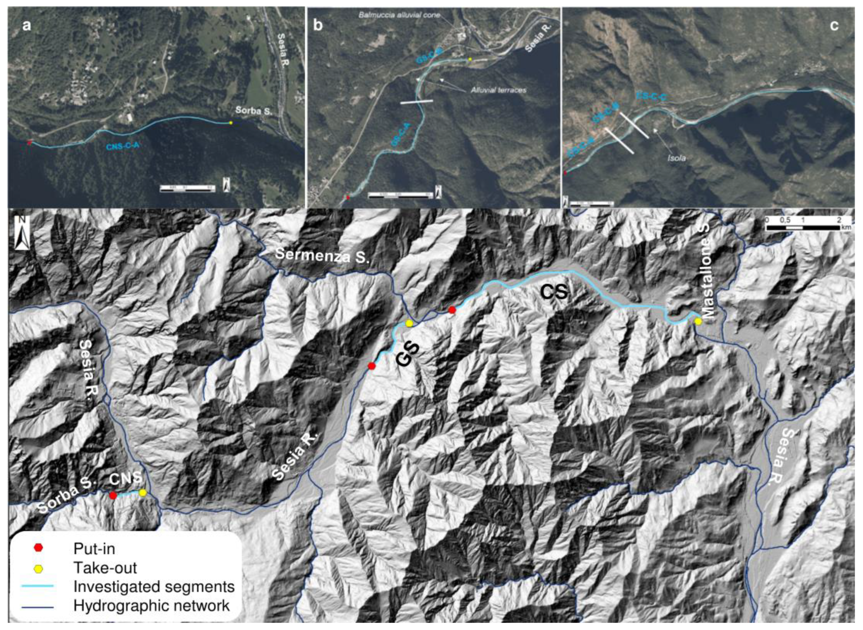
3.1. Selection of River Segments

The segments of Sesia river and of Sorba stream were selected since they are among the best-known locations for rafting and canyoning activities in the Sesia Valley. Moreover, along the traits, in the core of the Sesia Val Grande UGGp, the relation with geological backgrounds is evident also at first sight. This area is very famous for the outcrop of rocks related to the Sesia Supervolcano [30]. The fluvial segments used by river guides to lead rafting and canyoning experiences were digitalized as polyline shapefile. In particular, 3 segments were identified (Table 3): (i) the Classico del Sesia (Sesia Classic—SC); (ii) the Gole del Sesia (Sesia Gorges—GS); and (iii) the Canyoning Sorba (CNS). Moreover, the put-in point and the take-out point locations for rafting and canyoning were digitalized along both the streams: these points defined only the commercial traits.
Each segment was divided into reaches according to the different features described in detail below (i.e., bedrock features, confinement, sinuosity, bankfull bottom, and morphological units). Then, a code, composed of 3 parts, was assigned to each segment: XX-Y-ZZ. They corresponded to: XX, the segment (GS, CS or CNS); Y, the feature (G = Geology–Bedrock features; C = Confinement; S = Sinuosity; B = Bottom; M = Morphology); and ZZ, the progressive code. All the subdivisions are reported in Supplementary S1, with the idea of finding a correlation between the different determined reaches, according to the different factors.

3.2. River Reaches Determination and Classification

The classification of the river traits was performed using the criteria proposed in the IDRAIM (system for stream hydromorphological assessment, analysis, and monitoring; [46]), aimed at introducing the use of fluvial geomorphology as a key component for river management [47]. The IDRAIM proposes an integrated approach for the assessment of hydromorphological quality of rivers as complex systems including also the biotic component. Since the aim of this research is not the evaluation of the Morphological Quality Index of the investigated streams, we only considered few criteria proposed by the method in the very first phase of the procedure (i.e., Phase 1, Characterization of the fluvial system). These criteria are described in the next subparagraph.
Moreover, being rafting and canyoning the focus of this research, detected morphological units featured by a rapid were also classified according to the difficulty and hazard degree. For the rafting practice, the classification followed the Whitewater Scale proposed by the Appalachian Mountain Club [48], based on the vulnerability of the user inside the river when swimming, and after described in detail. Concerning canyoning, the adopted system is different, and it is based on three main elements: Vertical Character, Aquatic Character, and Commitment, as described later.
Particular nicknames given to the reaches (i.e., morphological units, mainly rapids or steps), according to user’s experience, landscape features, and natural hazards, in both rafting and canyoning, have been annotated. When the nickname changed after the 2020 event has been also annotated.

3.2.1. Characterization of the Fluvial System according to IDRAIM

Physiographic unit’s determination was the first step of the procedure. In our case, the Sesia and Sorba water courses drained mountainous areas, thus the physiographic unit was the same: mountainous. Then, along the 3 segments identified for the analyses (Table 1), the bedrock features (i), the confinement (ii), the sinuosity (only for single channel traits) (iii), the bankfull bottom (iv), the morphological unit (v), and the steepness of the traits (vi) were used to distinguish the reaches.
(i)
Bedrock features—according to the IDRAIM method, the distinction between rock types is related to the susceptibility of rocks to water erosion. In our specific case, the area features metamorphic rocks, which, if apparently similar, show different resistances to erosion, producing different kinds of fluvial landforms. In order to analyse this factor, the map by Quick et al. [45] (1:25,000 spatial scale) was used for the Sesia river segments (GS-CS), while the lithology was derived from the shapefile available from the Piemonte region WebGIS services for the Sorba stream (CNS) (Table 2), with a resolution of 1:100,000. Moreover, the information was also compared with a geological map of the Sesia Val Grande UGGp ([30]; Figure 2). The 3 segments were divided into traits, considering the lithological contacts between units when significant and influent on fluvial morphology.
(ii)
Confinement Degree and Index—the Confinement Degree (DC) represents the percentage of the length of the reach not in contact with the alluvial plain but confined by rocks. Confined traits are usually more than 90% bordered by slopes and ancient morphological elements (e.g., fluvial terraces), while, on the contrary, unconfined traits are less than 10% in contact. The Confinement Index (IC) is calculated as the ration between the alluvial plain width, including the bankfull channel, and the bankfull channel width. Confined settings show the IC composed between 1 and 1.5, while the confinement index is considered medium-to-low for values greater than 1.5. Combining the 2 values, the final confinement class is determined.
(iii)
Sinuosity Index (IS)—this index is calculated only for single channel traits as the ratio between the length of the bankfull axe and the length of the valley axe. A straight reach is defined with a IS lower than 1.05, the reach is sinuous if the IS is between 1.05 and 1.15, and it could be classified as meandering if even greater.
(iv)
Bankfull bottom configuration—the distinction between those with a rocky bottom and alluvial or semi-alluvial bottom reaches was also made. To distinguish between the categories, the continuity of the alluvial material or rock is important. This property is related to flow energy and steepness of the bottom.
(v)
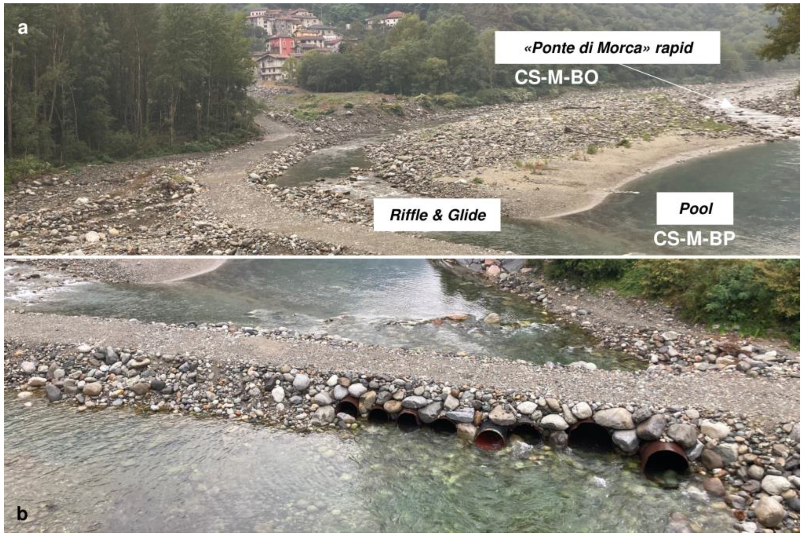
Morphological unit definition—rafting and canyoning are strictly dependent on specific morphologies such as cascades, rapids, riffles, glides, steps, and pools. Along rafting reaches, it is improbable to find cascades and steps, while it is possible to meet all the morphological conditions along canyoning reaches. The morphological units were defined according to IDRAIM classification.
(vi)
Steepness of the bankfull bottom—the altitude profile of the river bottom was finally extracted from the Digital Terrain Model (DTM—5 m resolution, Table 2) using the “3D Analyst tool—Interpolate” line of ArcGIS 10.2.1. These data were used to especially confirm morphological units along the investigated segment. Since the DTM with 5 m resolution is relative to the 2009–2011 time interval, in a dynamic environment such as a fluvial environment, the differences that occurred in a 10-year time interval (from the DTM survey and the current analysis) could be very significant, as discussed in the results.

3.2.2. Classification of Rafting Features (i.e., Rapids, Riffles, and Glides) and Canyoning Reaches according to the Difficulty Degree

In order to classify the morphological units, those at point v) of 3.1.1 were defined as rapids, according to the difficulty degree for the river outdoor activities, and the Whitewater (WW) classification system was adopted for the rafting reaches along the Sesia River [48,49]. The same classification, in this specific case, was also extended to riffle and glide morphological units. Instead, for canyoning, a specific classification was considered.
In more detail, the observed morphological elements for rafting are the rapids, indeed also known as “white waters”. The international scale is based on the vulnerability of the user inside the river, especially considering the swimming conditions after the potential loss of the raft. For instance, the classes are V, beyond that value, people dealing with the rapid most likely run into serious damages if forced to swim. From I to V, the classification is as reported in Table 4. In specific cases, riffles and glides were classified with this system too, always with a value of I WW due to the impossibility of swimming inside the river and of being injured if raft goes lost.
Concerning canyoning, according to the Fédération Internationale de Canyonisme (FIC) [50], the difficulty of the reach for the user is related to the features reported in Table 4. Moreover, from a morphological point of view, there is no clear distinction between easy and difficult canyons because one can modify the path according to the needs of the group of people [26].

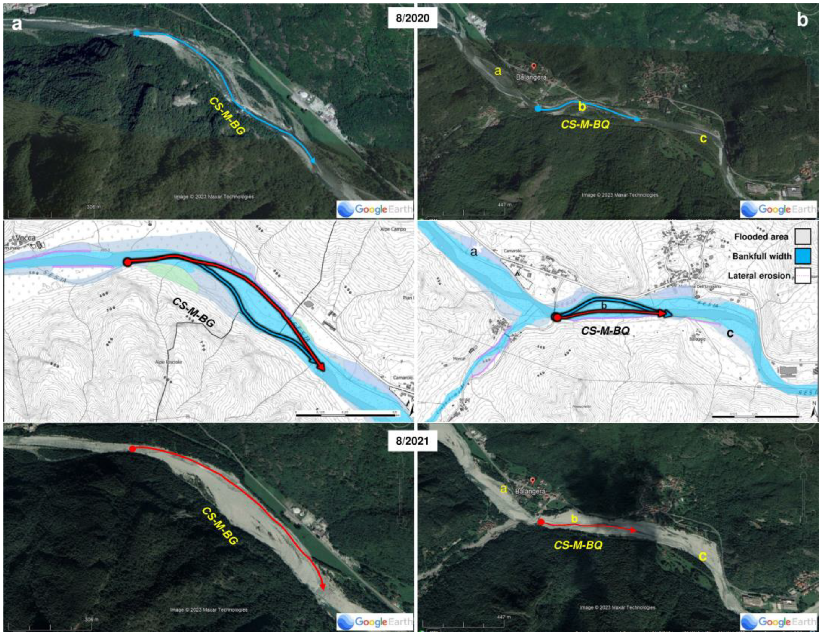
3.3. Analysis of the Effects of the 2020 Extreme Meteorological Events on Fluvial Morphologies

Concerning the disastrous event that occurred on 2–3 October 2020, a literature review was performed considering the online databases available for the hydrogeological instabilities events affecting the Piemonte region (Table 2). Two databases were available: the Hydrogeological Events Database Piemonte region (BDE) and one specific for the 2020 event (Database of the effects of the 2020 event; Table 2). Moreover, in 2021, a Special Volume collecting the data from the analyses of the event was also published [31].
The literature analysis was accompanied by field surveys (from May to September 2021 and 2022) aimed at identifying the greatest morphological changes occurred during the 2020 event and the consequences of rafting and canyoning practices.

4. Results

4.1. Characterization of the Fluvial System according to IDRAIM and Classification of Rafting Features

In Supplementary S1, the results of the subdivision reaches are collected. The reaches, in which the segments Gole del Sesia (GS), Classico del Sesia (CS), and the Canyoning Sorba (CNS) are divided, are characterized according to the different considered criteria. Each reach is reported with the relative codes, as explained in Section 3.1.
(i)
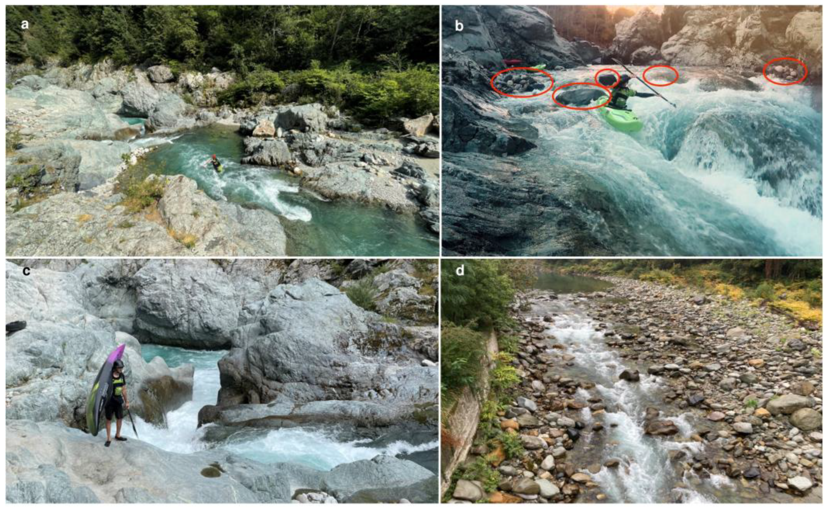
Bedrock features—The GS and the CS segments are totally included in the Sesia Supervolcano area. The CNS, instead, is located within the Austroalpine Domain. The units incised by Sesia River in the study section belong mainly to the Canavese Zone and to the Mafic Complex. The contact between the Canavese Zone and Mafic Complex corresponds to the Insubric Line. The Canavese Zone’s rocks are characterized by mylonite structures in greenschist facies, intensively deformed and foliated as a consequence of the Insubric Line action. The rocks of the Mafic Complex are less susceptible to erosion, even if the local occurrence of fractures may increase this property. Moreover, the Balmuccia peridotite (pre Permian mantle rock) represents a strong obstacle to incision by the river. Five main reaches were detected along the GS, which, according to Quick et al. [45], run along the Insubric Line crossing it three times. GS-G-A and GS-G-E flow into mylonite (22.80%), GS-G-B (Figure 4a), GS-G-D, and GS-G-F run into amphibolite gabbro (77.20%), and a very short reach in the middle (GS-G-C) flows across an ultramafic cumulite. The river morphology is characterized by the presence of a beautiful gorge in correspondence of the amphibolite gabbro and ultramafic cumulite. This morphology is related to rock resistance, and the location of the incision could have been favoured by the presence of a weakness line. Along the reaches GS-G-E and F, the mylonite and amphibolite gabbro are covered in the [45] map by Quaternary deposits of different ages: older fluvial terraces or more recent alluvial deposits.
The CS segment runs entirely in the Supervolcano area. Herein, three reaches are defined according to the lithology change: CS-G-A is carved in the Balmuccia peridotite (5.7%), and CS-G-B and C (94.3%) flow into Quaternary deposits below which, respectively, the gabbro and norite and the Valsesia diorite of the Mafic complex are mapped [45]. Of particular note is the straight fluvial gorge that perfectly corresponds to the Balmuccia peridotite outcrop (CS-G-A, Figure 4b).
The CNS segment is located within the Austroalpine Domain, the portion of Africa’s paleomargin northern to the Insubric Line. The segment (CNS-G-A; Figure 4c) is carved inside the Gneiss Minuti Unit, according to the lithological map of the Piemonte region (Table 2). Herein the location of the gorge might have been controlled by the presence of weakness lines (i.e., minor faults among which those reported in Figure 2) parallel to the river flow.
(ii)
Confinement Degree and Index—The three investigated segments present variable confinement degrees and indexes (Figure 5 and Figure 6a), with some reaches completely confined by rocks, showing impressive gorges that allow rafting or canyoning. The CNS segment (CNS-C-A) is totally confined (Figure 5a). The GS segment (Figure 5b), as the name itself shows, is confined for more than the 80% of its 1908 m total length. A gorge characterizes the longest portion of the GS segment (GS-C-A; length of 1241 m, 65.04%), and the river is confined (IC = 1). The other portion of the GS (GS-C-B; length of 667 m, 34.96%), ending in the correspondence of the Balmuccia alluvial fan, is featured by a medium confinement (IC = 2.68). The CS (Figure 5c) is quite variable in terms of confinement. In particular, there was a first confined reach with an IC of 1 (CS-C-A, length 770 m, 9.35%), and, after, there are 2 medium confined reaches with ICs between 1.92 and 4.7 (GS-C-B and C, lengths of 363 and 7105 m, respectively, for a total of 90.65%).
(iii)
Sinuosity Index—The IS of the first reaches of both the CS (CS-S-A; 13.75%) and CNS (CNS-S-A; 100%) (IS = 1.05) indicates a straight pattern (Figure 6b). The entire GS (GS-S-A; 100%) is sinuous (IS = 1.15). The second portions of the CS (CS-S-B; 86.25%) is slightly sinuous (IS = 1.13). This sinuous reach is also medium confined, while the GS sinuous segment is confined to the medium confined. A straight pattern could possibly be associated with a structural control on landforms.
(iv)
Bankfull bottom configuration—The three investigated segments are characterized by alternating semi-alluvial and rocky bottoms. The GS is featured in the middle part for more than a half of its length (55.82%) by a rocky gorge carved in the Mafic Complex rocks (GS-B-B; Figure 6c). The rocky gorge of CS (CS-B-A; 5.90%; Figure 6c) is incised within the Balmuccia peridotite layer. Then, the two rocky steps along the Sorba segment are carved in Gneiss Minuti (CNS-B-B and D; 53.65%; Figure 6c). The remaining reaches (46.35%; Figure 6c) are semi-alluvial with recent alluvial deposits or ancient terraces and only sparse boulders.
(v)
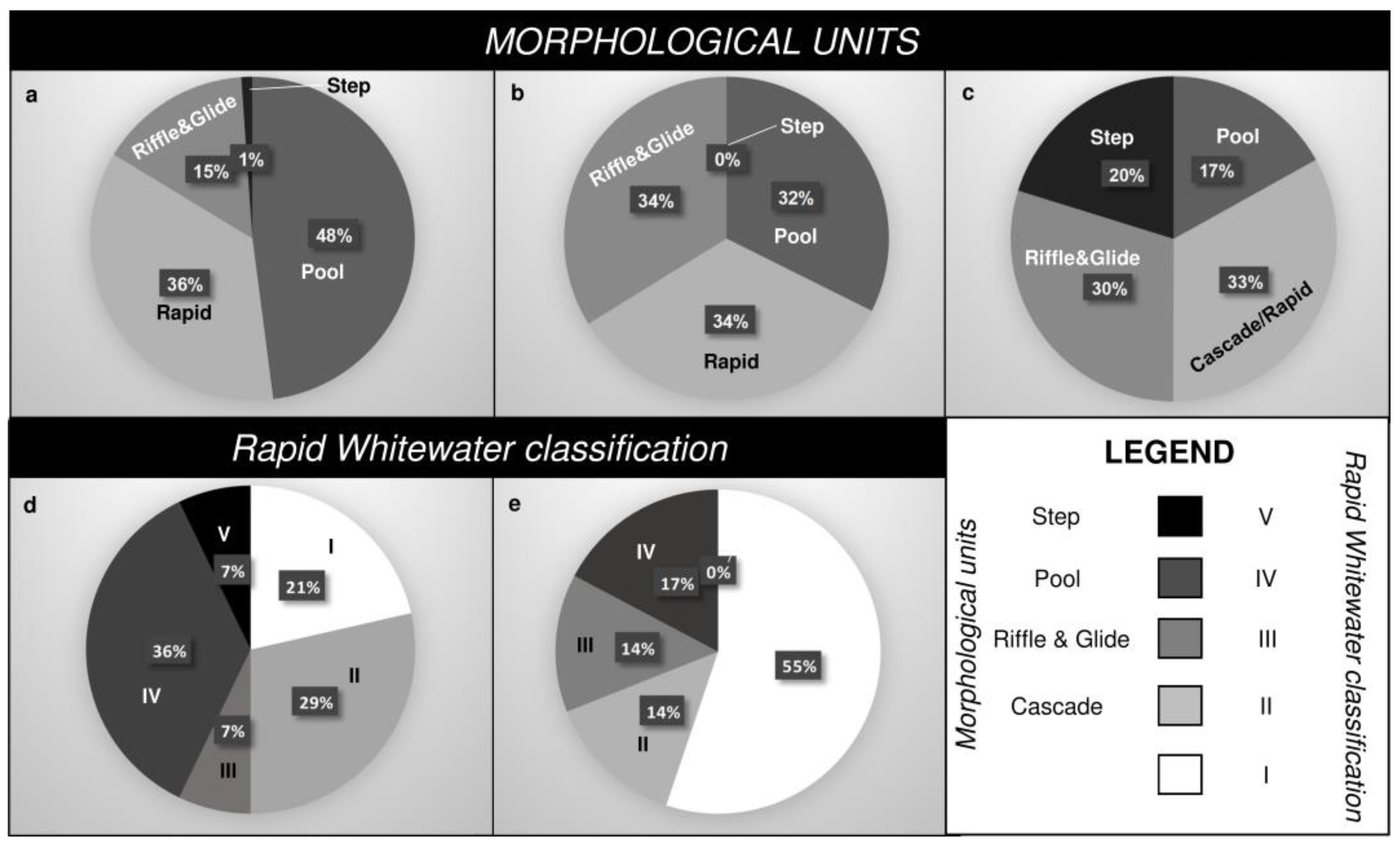
Morphological unit definition—As evidenced by the graphs in Figure 7, the variability of the morphological units is different, by one segment in respect to the others. As emerged from the spatial distribution shown in Figure 8, and as described before, morphology types alternate along the segments. The greatest variation regards the presence of morphological steps, more recurrent in the CNS (20.20%), where canyoning is practiced, with respect to GS (1.10%) and CS, where, in the last one, they are totally absent. For this reason, rafting there is not practicable. The presence of steps along the CNS may be connected to the occurrence of minor faults transverse to the river flow. The river energy produced in correspondence of the steps is translated in a greater erosive capacity by the river and in the consequent genesis of a pool. Concerning pools, they are the most recurrent morphology along the GS (47.96%), followed by rapids (35.74%). Rapids and pools alternate along the gorge (GS-C-A, GS-S-A), and their high hydrodynamic energies do not favour the debris accumulation, and the morphologies of the riffles and glides is not usual. Riffle and glide morphologies feature only 15.20% of the GS, along the semialluvial portion (GS-C-B, GS-S-B) and as far as the steepness increase nearby Balmuccia. Along the CS pools, rapids, riffles, and glides are similarly represented (32.36% to 33.82%). They alternate quite regularly all along the segment. Rapids and cascades feature an important part of the CNS (33.15%), and 29.75% are characterized by riffles and glides.
Concerning the Whitewater classification, rapids, riffles, and glides of different WW degrees are present along the CS and GS segments (Figure 9). It is worth to mention that riffle and glide units were classified as WW Class I, since the vulnerability is almost zero, being impossible to swim into. Rapids represent the 36% of the GS segment. This segment shows a discrete percentage of difficult rapids (from Advances—IV—to Expert—V; 43% in total) (Figure 9a; GS-M-AM, 9b, GS-M-AP), and one is classified as impracticable, meaning that one cannot go through it without any serious damage (Figure 9c, GS-M-AN). GS is also featured by a 50% of class I (General user) plus class II (Novice), while class III (Intermediate) is the less frequent. CS is dominated by class I (55%), while classes II, III (Figure 9d, CS-M-AP), and IV are quite equal (14–17%). Along this segment, no rapids for expert (V) are present.
The CNS is the investigated segment used for canyoning; hence, the difficulty degree is defined according to different criteria: Vertical character, Aquatic Character and Commitment. The values obtained for the whole segment are, respectively, two (over seven), three (over seven), and II (over VI) (see Supplementary S1).
(vi)
Steepness of the reaches
The three segments are featured by different steepness. The average steepness values are 3.3% (GS) and 2.2% (CS) along the Sesia segments used for rafting, while it increases to 9.3% along the Sorba segment used for canyoning (CNS). In Figure 10, the different morphological units are reported on the steepness graph extracted from the DTM (Table 1) by means of the 3D Analyst tool of ArcGIS. As already mentioned, it is worth to consider that the DTM with a 5 m resolution is relative to 2009–2011, and, in a dynamic environment such as the fluvial one, differences could be very significant in a nearly 10-year time interval. Moreover, the entity of the resolution (5 m) is also to be taken into account. We prepared the graph to show the general correspondence between the altitude profile and the morphological units described before. On the figure, the nicknames of specific traits of the fluvial segments used in rafting and canyoning, mainly rapids or steps, are reported in relation to their spatial distribution, visible in Figure 8.

4.2. Effects of the 2020 Extreme Meteorological Events on Fluvial Morphologies and Rafting and Canyoning Difficulty Degree

Following the 2020 event, occurring immediately after the end of the canyoning and rafting commercial season along the Sesia river and Sorba stream, several changes were surveyed. During the 2021 and 2022, field surveys were systematically conducted to understand the morphological variations and the consequences of canyoning and rafting. Indeed, after intense events such as the 2020 event, a periodic check of river conditions, especially during spring by the fluvial operators (i.e., scouting), is indispensable. The most impressive changes regard the Classico del Sesia, as described below.
The first most important consequence detected along the investigated segments concerned the variation in the difficulty degree of some rapids or, in some cases, the total disappearance of the historical and traditional rapids due to river diversion. The most evident case occurred at the reach along the CS, named CS-M-BQ, near Morca (Figure 11, on the left). Other important changes occurred at the New Team rapid (CS-M-BZ; IV WW degree), prior to the 2020 event of easy access, and is now not practicable anymore, forcing the take-out and put-in of the raft down valley to it. The Scatafascio rapid (CS-M-BL; IV WW degree), even if undergoing a similar evolution, was restored by natural debris transportation. The conditions reported in Supplementary S1 are related to the current situation after the 2020 event.
Additionally, the human interventions following the events introduced significant changes along the river. Syphons and whirlpools, which are very engaging for navigation and canyoning practice, may be indeed also artificially created, as in the case of the reach along the CS near Morca (CS-M-BP) after the Ponte di Morca rapid (Figure 12). These interventions consisted also in the activation of an alternative channel to the main one with a riffles and glides pattern (Figure 12a). Gradually, the river is abandoning this artificial trait, leaving active only the main channel (the one considered in this study) (Figure 12; CS-M-BO; CS-M-BP). In order to create a path for machinery used to refurbish the riverbed after the event, many metal pipes have been located within the riverbed itself, with the problem of hurting and creating dangerous situations for rafting practitioners.
The reaches in this area are particularly dangerous for another reason also. The rapid, featuring the reach CS-M-BG, is now currently named Impalatore (Impaler) or Alberi (Trees). Indeed, the diversion of the main channel induced the passage of the rafts over the floodplain, existing before the 2020 event (Figure 13), which was previously vegetated by arboreal species too. Trees were not totally removed during the 2020 event, and successively decapitated trunks may represent serious danger for navigation. Now, the situation is going to be refurbished.

5. Discussion

According to the GEmMA—GEodatabase Morfologia corsi d’Acqua in Piemonte (Table 1)—containing the data about the quality of rivers in Piemonte region, measured using the IDRAIM procedure, the investigated reaches along the Sesia river (GS, CS) are classified as good to excellent quality. The Sorba stream (CNS) is instead not present in the database. In more detail, the reaches flowing along the gorges (GS-C-A; CS-C-A) are classified as of excellent quality.
In the GEmMa database, the second reach of the Gole del Sesia (GS-C-B) is characterized by the presence of artificial levees for 10–50% of its length, while the other reaches are less than 10%. Again, the river defence works are less than 5%, except for the reaches GS-C-B and CS-C-C, where they are present in the range 5–33%. This parameter is considered in the calculation of the Quality Index. It is worth noting that the percentages indicated are relative to traits that are longer than those considered in the present work in the system, since these latter end where the rafting commercial activity ends. These investigated segments are, indeed, used for outdoor river activities, and the Sesia River, in particular, is very famous to both experts and beginners. Just in view of these activities, the bedrock incised by the river flow is important as both the water discharge and the fluvial regime. The lithology and the morphometric features of the riverbed, including steepness, bankfull width, and morphologic units, deeply influence the difficulties of the rafting and canyoning activities, as discussed later on.
In Supplementary S1, in addition to the subdivision of segments in relation to each adopted criterion, a potential correlation is proposed between these subdivisions, obtained using the IDRAIM criteria (i to v, par. 4.3). The subdivision, according to morphological units (criterion iv), has been taken as a reference, being the most numerous reaches. When the limit between the reaches according to criterion ii to v is not perfectly correspondent with the limits, according to the morphological unit subdivisions, a dashed line is used. The discrepancy between the subdivisions is always lower than 150 m.

5.1. River Outdoor Activities and Geological Time Scale Processes

The morphological units in which the Sesia river segments have been subdivided find great representativeness of rapids and pools. These second ones are important elements, since they allow for recovery after the commitment of a rapid, waiting for the other rafts involved in the descent to join, or explaining to the crew some techniques to enjoy by swimming or diving into the river, a practice common also along the gorges. In the view of geotourism, the pools represent an ideal place to explain to people involved in rafting the geological and geomorphological peculiarities influencing river activities along the river, in this specific case, mainly the Sesia Supervolcano’s features.
The morphological alternating pattern, clearly visible along the Classico del Sesia (Figure 8), depends on long time scale parameters, both geological and geomorphological, linked to bedrock features (lithology and structures) and steepness. Additionally, yearly variations may occur, but their recurrence could be considered not so relevant, even if they may provoke deep changes during exceptional events, as shown.
Another relevant fluvial morphology that favours a temporary stop when descending a rapid is the eddy (Figure 14 a,b), a river feature that forms downstream to an obstruction, such as, for instance, a rocky outcrop along the riverbed, where water is relatively calm and flowing opposite respect to the main flow, allowing one to find a sort of shelter. Managing an eddy requires great ability from the driver. The presence of eddies is very important where pools are rare along a river segment, and, along the Sesia river, eddies are frequent due to the recurrence of rocky outcrops. The Sesia river is prone to this kind of morphology, as its bankfull bottom is mainly rocky or semialluvial. The bedrock in the case of the Sesia river is constituted by peridotite, gabbro, and diorite, implying long time modelling. Hence, eddies may represent another potential occasion to explain to people the morphology of the river and lithology outcropping along the riverbed in the Sesia Supervolcano area.
Other relevant elements influencing rafting activity are fluvial gorges (Figure 4 and Figure 12c,d). In the analysed segments, the most important gorges are located along the Gole del Sesia (GS-C-A; GS-B-B), the Classico del Sesia (CS-C-A; CS-B-A; CS-M-AA, Figure 14c), and along the whole Canyoning Sorba (CNS-M-D, Figure 4 and Figure 14d). In the current context of climate change, where drought events (such as those occurred in 2022 [51]) and water resources are undergoing severe modifications [52,53], low water levels may represent a real issue for rafting experiences. In this context, where extreme meteorological events are also becoming even more recurrent [5], water discharge along the river is very mutable. If some traits are quite impracticable in some conditions of low water (Figure 9d, CS-M-AP), gorges represent a fundamental alternative. Thus, in the case of Sesia, the Gole del Sesia is the first choice during the drought season (i.e., summer), which is also when the number of demanding tourists increase. Despite water level variations, which may be considered in the described cases as a short time variation, the genesis of a gorge asks for a long time interval and is treated herein for this reason. The short time variations are, instead, treated in the next paragraph.
The Gole del Sesia gorge (GS-C-A) is carved into the amphibolite gabbro and ultramaphic cumulite of the Sesia Supervolcano (GS-G-B/C/D, Figure 4). The gorge is quite steep, and, herein, pools are abundant and rarely filled in with debris. The very beginning of the gorge is actually carved into mylonite of the Canavese Zone (GS-G-A; Figure 4), where the rapid, named White Buffalo (graded VI+ and not included in the investigated segments), is located just before the pool of the put-in point along the Gole del Sesia (GS-M-AA). This put-in pool is an ideal place to speak about the Insubric Line and the mylonite deriving from its tectonic action, and about the contact with the Mafic Complex of the Sesia Supervolcano, visible during the descent.
Along the Classico del Sesia, another gorge is present, which is carved in the peridotite nearby Balmuccia. In this gorge, there is a rapid of WW VI+, which is not used any more for commercial purposes due to vulnerability issues. Immediately down valley, the Classico del Sesia starts with a pool (CS-M-AA; Figure 4 and Figure 14c). This pool is ideal for diving into the river.
Instead, regarding canyoning, the whole CNS may be defined as a gorge. Canyoning is an activity that could be practised along river traits featured by long time scale features such as kart canyons, fluvial gorges, and volcanic barrancos [26]. As mentioned above, the difficulty degree in featuring this outdoor river activity is calculated considering Vertical and Aquatic Characters as well as the Commitment that includes the escape possibilities. This feature depends on the general geology and geomorphology of the area, its characters change over a long time scale. A beautiful view of the toboga, carved in the Gneiss Minuti Unit along the Canyoning Sorba, is reported in Figure 14d (CNS-M-D).
In summary, considering the correlation table in Supplementary S1, the main emerging aspect is the correspondence between gorge morphology, confined traits, and specific rocks less susceptible to erosion, such as in Balmuccia peridotite: GS-G-A to D/GS-C-A/GS-B-A to B and CS-G-A/CS-B-A/CS-C-A. Moreover, where the Sinuosity Index reports a straight pattern, the location of the gorges may be considered related to a local weakness line of a structural origin (CS-B-A/CS-S-A; Figure 4b). The outcrop of Balmuccia peridotite is of great scientific value and, influencing river configuration, it may be an interesting topic in the view of geoscience’s outreach. Concerning CNS, the gorge’s morphology, featuring the entire segment, is straight, suggesting, in this case, a structural control of its location. The CNS gorge is characterized by some changes in the bankfull bottom configuration and morphological units that can be mainly associated with steepness changes, rather than the lithology itself, which remains the same all along the segment. Transversal structures such as fractures in gneiss may also influence step locations.
In mountain areas located in an active tectonic context such as the Alps, where the average vertical uplift is estimated to be 1 mm/a, the component of endogenous factors is empowered by the deglaciation occurring after the Last Glacial Maximum. Afterwards, indeed, a re-equilibrium phase induced a significant increase in the river incision in mountain settings to 1.6–1.7 mm/a [54]. This is another example of a long time scale change.

5.2. River Outdoor Activities and Short Time Scale Events: The Case of the 2020 Event

In this category of river changes, all of the variations considered possible at a human scale (i.e., water discharge variations and alluvial deposits redistribution for extreme meteorological events) are included. These features are very important because they ask for a periodic check, especially during spring, of river conditions by the rafting operators (i.e., scouting). When low water levels occur, the scouting is indispensable to check the potential obstacles present along the segment (Figure 9d, CS-M-AP). If the water level is very high, the gorges may be too dangerous to practice rafting in, or it may occur that the previously mentioned obstacles may be hidden, and the formation of whirlpools and syphons down valley may contribute to the rollover of the raft. This occurs, for example, along the rapid GS-M-AG, graded to the V WW degree, where a series of submerged coarse debris may provoke the formation of syphons and whirlpools. The same syphons may be created by woody debris (CS-M-BG; Figure 13b), or, artificially, when interventions along the river are aimed to refurbish the effects of extreme alluvial event, as described before for the Morca area (CS-M-BP, Figure 12b). The debris may be moved during extreme meteorological events and should be monitored. Additionally, the visible debris may have the same destiny (GS-M-AP, rapid Nicchia, IV WW degree; Figure 9b).
Moreover, the sudden increase in the water level during an extreme meteorological event or a flash flood along a tributary stream may represent a serious hazard for people along the river, especially where the escape routes are not so straightforward. In Figure 14 (d, CNS-M-D), the toboga can become very dangerous when water level grows. Concerning flash floods, they could be very dangerous with the short time of propagation along the hydrographic network, especially where the very impermeable metamorphic and magmatic rocks outcrop, such as in the investigated area. During flash floods, great amounts of debris (rocks and wood) may be transported along the river, modifying the morphology. Lateral erosion along riverbanks may contribute, becoming a relevant problem too, occurring along the reach CS-M-AI (Figure 13a).
When a sudden input of a great quantity of debris after a landslide event occurs, it may induce the diversion of the main channel [55], which may assume a meandering pattern. The flash floods, mentioned before, may also be due to landslides completely blocking the river’s course, when the landslide body is successively dissected, and the water is suddenly released down valley. The same may also occur in the case of alluvial fans’ formation (e.g., CS-M-AN), but, in this case, the time scale of the change is evidently longer, and the changes are gradual and more comparable to those described in the previous paragraph.
In the case of canyoning, the debris falling from the riverbank and the syphons and whirlpools represent the most important hazards, even if not usually present within commercial traits, such as the one investigated. Moreover, the potential debris accumulation inside a pool may induce a lowering of its depth, a hazard with respect to diving in practice. In this case, the scouting practice, including measurements of the pool’s real depth, becomes essential before safely facing such practices, especially with customers. Furthermore, after an extreme meteorological event, the suspended load and turbidity may increase the hazard, masking obstacles and making the scouting activity even more difficult.

5.3. River Outdoor Activities for Geoeducation Opportunities

Opportunities for dissemination through georafting are significant, as already noted before. Despite this, few georafting proposals are available to tourists, as those in the Austrian Steirische Eisenwurzen UGGp [8,27,28]. In the general framework of outdoor activities for Earth Sciences’ dissemination (e.g., [13,15,18,19]), georafting should also be considered more systematically, according to the local geological and geomorphological features (as performed for geoclimbing [18,19]. Analysing these is fundamental before setting these kinds of outreach opportunities, especially in areas such as UGGps. The IDRAIM methodology allowed a systematic classification of river reaches, considering factors acting at different spatio-temporal scales, such as bedrock and geomorphological features, as well as the human interventions along riverbeds.
A sort of methodology, hence, could be structured, trying to enhance the local effects of geological and geomorphological features at different time scales over rafting and canyoning practices. In the Sesia river and Sorba stream, the main geological peculiarities that emerged were the presence of specific rocks related to the Sesia Supervolcano and the Insubric Line, strictly influencing river morphologies and rafting and canyoning practices. Moreover, the impacting event occurred on 2–3 October 2020, characterized by a different time scale and producing very evident changes in morphologies along the reaches, with consequences on rapids difficulties, may be used to communicate the dynamism of the landscape, also in relation to climate change. In this sense, the topic of natural hazards communication to the general public (e.g., [56]) and also to school students [12] may be considered a good practice. Since the difficulty of the rafting and canyoning reaches is fundamental to be evaluated, this also asks for the specific involvement of river guides in the setting of educational activities.
The investigated area features several geosites of the Sesia Val Grande UGGp [30], an aspect that can favour the empowerment of outdoor activities in the perspective of geoscience’s education and outreach. For instance, there is the possibility of creating specific thematic package tours to be offered to schools or tourists. Some examples of similar packages for schools were realized by Bollati et al. [19], which proposed geoclimbing and geotrekking for two groups of students interchanging during the day. This activity is part of the programme of the international IGCP-714 project funded by the UNESCO IGCP Programme (“3GEO-Geoclimbing and Geotrekking in Geoparks: methods and tools for enhancement, sustainable fruition and educational projects”). Local operators such as rafting or canyoning guides (supervising the descent along the river) and environmental guides of the UGGp (taking care of the cultural and scientific content) may hence collaborate each other under the auspices of the UGGp to propose such packages. In the case of the Sesia Valley, the proposal could be a georafting experience alternated with geotrekking or geobiking to visit geosites, such as along the Sesia Supervolcano geotrail. This experience has been already tested but not deeply structured in the area and represents a nice future perspective [57].
Outdoor activities and geoscience’s dissemination may finally allow to reach, as discussed briefly in the Introduction, some of the main Sustainable Development Goals (SDGs) listed by United Nation, and summarized in Table 5. Concerning the activities with youths based on georafting [28], geocanyoning, geotrekking, geoclimbing (e.g., [15]), as well as geobiking [20], for instance, may favour the achievement of SDGs n. 3, 4, and 11, granting wellness, awareness of natural resource values, and involving people in acquiring scientific contents also related to natural hazards. In this sense, the awareness about climate change effects (SDG 13) could be acquired through such activities, as demonstrated in our study case where extreme events, such as the 2020 one, could be explained in the context of a global change. Concerning SDGs n. 8 and 17, undoubtedly, the presence of entities such as UNESCO Global Geoparks, promoting such activities, is a key point, even if also the not-yet-developed areas could benefit from such approaches. These geotouristic proposals, indeed, could help in creating new professional figures and increasing the employment opportunities in the tourist sector in the areas. As described before, indeed, local operators such as rafting and environmental guides may collaborate to create package tours for visitors interested in geosciences and outdoor activities. By creating partnerships among geographical areas with similar offers (e.g., between UGGps promoting similar outdoor activities such as georafting) and similar or different geofeatures (i.e., geodiversity), the SDG n. 17 is favoured to be achieved. Thinking at a more local scale, in relation to SDG n. 8, partnerships between local operators may be another way to achieve SDG n. 17. SDG n. 5 on gender equality seems the only one in the list to be quite far from being realized. Indeed, Dubreuil Karpa [58] complained about the still persisting masculine views in the outdoor guides’ sector, both from colleagues and from customers, in many cases, reluctantly trusting women guides’ skills. Several initiatives at an international level may start to promote the empowerment of women figures in general (Figure 1a), and special efforts could be performed at the specific scope of outdoor activities.

6. Conclusions

Outdoor activities such as georafting and geocanyoning may allow for the increase in awareness about landscape origins and their current evolutions in both a long and short/human time scale. Both topics, indeed, demonstrated relevance, since the parameters measured using a consolidated approach such as IDRAIM may allow for a systematic analysis of such environments. This approach has never been adopted before for georafting and geocanyoning analyses. On one side, bedrock features clearly influence river morphologies over a long time scale, conditioning the other parameters investigated: Confinement, sinuosity, bankfull bottom, and morphological units. Bedrock lithologies and structures, for instance, contribute to influencing the positions and morphologies of gorges and steps. On the other side, extreme events may suddenly change the morphological units of a river (e.g., channel diversion, change in the difficulty degree of rapids, increasing hazard due to woody and rocky debris), asking for specific adaptations to new conditions and a frequent scouting of the river-by-river guides. Outdoor activities are never safe from risk, which, if not relevant, is residual rather than zero. The involvement of outdoor guides is, hence, a key point not only in analysing river conditions, such as in this case, but especially in the contexts of geoscience’s outreach. The involvement of local river guides in scientific research about river systems, in cooperation with environmental guides too, especially if aimed also at geoscience’s outreach, is precious in granting an additional employment opportunity for local operators. The seven illustrated Sustainable Development Goals (over 18), which can be achieved through outdoor activities in geosciences, may be even more if the research in this field progresses. Moreover, a future perspective may regard the application of the method to different areas in order to compare the results and increase partnership opportunities. Indeed, one limitation of this study is related to the relatively low variety of geological conditions in the study area to assess more robustly the relations between geofeatures and river morphologies. Testing systematically georafting and geocanyoning for geosciences education and outreach in the near future in the study area, with the cooperation of local operators, remains an additional future goal.

Supplementary Materials

The following supporting information can be downloaded at: https://www.mdpi.com/article/10.3390/geosciences13040122/s1, Supplementary S1: Supplementary S1 contains the data related to the subdivision of the investigated segments along the Sesia River and Sorba stream, according to bedrock lithology, structures, Confinements, sinuosity, bankfull bottoms, and morphological units. There is also a final sheet, where the spatial correlations between these features are shown.

Author Contributions

Conceptualization, I.M.B. and D.R.; methodology, I.M.B. and D.R.; software, I.M.B. and D.R.; validation, I.M.B.; formal analysis, D.R.; investigation, I.M.B. and D.R.; resources, C.V., I.M.B. and D.R.; data curation, I.M.B. and D.R.; writing—original draft preparation, I.M.B., C.V. and D.R.; writing—review and editing, I.M.B., C.V. and D.R.; visualization, I.M.B. and C.V.; supervision, I.M.B.; project administration, I.M.B. and C.V.; funding acquisition, I.M.B. and C.V. All authors have read and agreed to the published version of the manuscript.

Funding

This work has been funded by (i) the University of Milan, grant number RV_TAR16VCAIR_M; and (ii) the Ministry of Education, University and Research (MIUR), Italy, through the project “Dipartimenti di Eccellenza 2023–2027” (DECC23_027_DIP), awarded to the Dipartimento di Scienze della Terra ‘A. Desio’ of the University of Milan.

Acknowledgments

The authors are grateful to the rafting company Monrosa Rafting, located in Balmuccia, Valsesia, for providing an extensive collection of field observations. In particular, thanks are due to Piero Arcostanzo and Mattia Depicolzuane for providing some images and to Simone Fossati for evaluating the degrees of difficulty of the Sorba. Finally, the authors are really grateful to the anonymous reviewers allowing a significant improvement of the manuscript.

Conflicts of Interest

The authors declare no conflict of interest.

References

  1. Pelfini, M.; Bollati, I. Landforms and geomorphosites ongoing changes: Concepts and implications for geoheritage promotion. Quaest. Geog. 2014, 33, 131–143. [Google Scholar] [CrossRef]
  2. Brilha, J. Geoheritage: Inventories and evaluation. In Geoheritage; Elsevier: Amsterdam, The Netherlands, 2018; pp. 69–85. [Google Scholar] [CrossRef]
  3. Bollati, I.M.; Crosa Lenz, B.; Caironi, V. A multidisciplinary approach for physical landscape analysis: Scientific value and risk of degradation of outstanding landforms in the glacial plateau of the Loana Valley (Central-Western Italian Alps). Ital. J. Geosci. 2020, 139, 233–251. [Google Scholar] [CrossRef]
  4. Gordon, J.E.; Wignall, R.M.; Brazier, V.; Crofts, R.; Tormey, D. Planning for Climate Change Impacts on Geoheritage Interests in Protected and Conserved Areas. Geoheritage 2022, 14, 126. [Google Scholar] [CrossRef]
  5. Palomo, I. Climate change impacts on ecosystem services in high mountain areas: A literature review. Mt. Res. Dev. 2017, 37, 179–187. [Google Scholar] [CrossRef]
  6. Gordon, J.E.; Crofts, R.; Gray, M.; Tormey, D. Including geoconservation in the management of protected and conserved areas matters for all of nature and people. Int. J. Geoheritage Park. 2021, 9, 323–334. [Google Scholar] [CrossRef]
  7. Gray, M. Geodiversity: Valuing and Conserving Abiotic Nature, 1st ed.; John Wiley and Sons Ed.: Oxford, UK, 2004; p. 448. [Google Scholar]
  8. Zouros, N. The European Geoparks Network. Geological heritage protection and local development. Episodes 2004, 27, 165–171. [Google Scholar] [CrossRef]
  9. Sustanable Development Goals. Available online: https://www.un.org/sustainabledevelopment/sustainable-development-goals/ (accessed on 28 March 2023).
  10. Witty, S. Bergsport als Gefährdungsfaktor für Pflanzen und Tiere—Tendenzen und Schutzmöglichkeiten. Schr. Für Veg. 1998, 29, 261–273. [Google Scholar]
  11. Orion, N. A Model for the development and implementation of field trips as an integral part of the Science curriculum. Sch. Sci. Math. 1993, 93, 325–331. [Google Scholar] [CrossRef]
  12. Bollati, I.M.; Crosa Lenz, B.; Zanoletti, E. A procedure to structure multidisciplinary educational fieldworks for understanding spatio-temporal evolution of the Alpine landscape. Rend. Online Soc. Geol. Ital. 2019, 49, 11–19. [Google Scholar] [CrossRef]
  13. Ruban, D.A.; Ermolaev, V.A. Unique Geology and Climbing: A Literature Review. Geosciences 2020, 10, 259. [Google Scholar] [CrossRef]
  14. Garlick, S. Flakes, Jugs, and Splitters: A Rock Climber’s Guide to Geology; Rowman & Littlefield: Lanham, MD, USA, 2009. [Google Scholar]
  15. Bollati, I.; Zucali, M.; Giovenco, C.; Pelfini, M. Geoheritage and sport climbing activities: Using the Montestrutto cliff (Austroalpine domain, Western Alps) as an example of scientific and educational representativeness. Ital. J. Geosci. 2014, 133, 187–199. [Google Scholar] [CrossRef]
  16. García-Rodríguez, M. Educación ambiental y deporte. Cómo la geomorfología condiciona la escalada. El ejemplo de la Pedriza del Manzanares (Madrid). Ensen. Cienc. Ti. 2015, 23, 320–329. Available online: http://www.raco.cat/index.php/ECT/article/view/306540/396520 (accessed on 28 March 2023).
  17. Bollati, I.; Fossati, M.; Zanoletti, E.; Zucali, M.; Magagna, A.; Pelfini, M. A methodological proposal for the assessment of cliffs equipped for climbing as a component of geoheritage and tools for Earth Science education: The case of the Verbano-Cusio-Ossola (Western Italian Alps). J. Virtual Explor. 2016, 49, 1–23. Available online: http://virtualexplorer.com.au/journal/2016/49 (accessed on 28 March 2023).
  18. García-Rodríguez, M.; Fernández-Escalante, E. Geo-Climbing and environmental education: The Value of la Pedriza granite massif in the Sierra de Guadarrama National Park, Spain. Geoheritage 2017, 9, 141–151. [Google Scholar] [CrossRef]
  19. Bollati, I.M.; Gatti, C.; Pelfini, M.P.; Speciale, L.; Maffeo, L.; Pelfini, M. Climbing walls in Earth Sciences education: An interdisciplinary approach for the secondary school (1st level). Rend. Online Soc. Geol. Ital. 2018, 44, 134–142. [Google Scholar] [CrossRef]
  20. Senese, A.; Pelfini, M.; Maragno, D.; Bollati, I.M.; Fugazza, D.; Vaghi, L.; Federici, R.; Grimaldi, L.; Belotti, P.; Lauri, P.; et al. The Role of E-Bike in Discovering Geodiversity and Geoheritage. Sustainability 2023, 15, 4979. [Google Scholar] [CrossRef]
  21. Baláš, J.; Giles, D.; Chrastinová, L.; Kárníková, K.; Kodejška, J.; Hlaváčková, A.; Vomáčko, L.; Draperet, N. The effect of potential fall distance on hormonal response in rock climbing. J. Sport. Sci. 2017, 35, 989–994. [Google Scholar] [CrossRef]
  22. Siegel, S.R.; Fryer, S.M. Rock climbing for promoting physical activity in youth. Am. J. Lifestyle Med. 2017, 11, 243–251. [Google Scholar] [CrossRef] [PubMed]
  23. Hrušová, D.; Chaloupská, P. Experiencing in Climbing and Psychological Effects of Sport Climbing. In Proceedings of the 7th icCSBs 2018 the Annual International Conference on Cognitive-Social, and Behavioural Sciences, Moscow, Russia, 14 November 2018; pp. 118–126. [Google Scholar] [CrossRef]
  24. Panizza, V.; Mennella, M. Assessing geomorphosites used for rock climbing. The example of Monteleone Rocca Doria (Sardinia, Italy). Geogr. Helv. 2007, 62, 181–191. [Google Scholar] [CrossRef]
  25. Picazzo, M.; Brandolini, P.; Pelfini, M. Clima e Rischio Geomorfologico in Aree Turistiche; Pàtron Editore: Bologna, Italy, 2007; p. 356. [Google Scholar]
  26. Motta, L.; Motta, M. La valutazione del rischio geomorfologico negli sport all’aria aperta: L’esempio del canyoning. In Clima e Rischio Geomorfologico in Aree Turistiche; Pàtron Editore: Bologna, Italy, 2007; pp. 295–320. [Google Scholar]
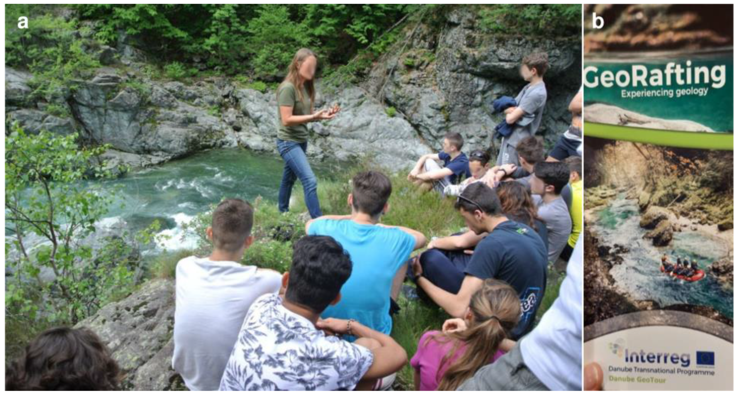
  27. GeoRafting—Experiencing Geology. Available online: https://fb.watch/hdHKDPaEDi/ (accessed on 28 March 2023).
  28. Gulas, O.; Vorwagner, E.M.; Pásková, M. From the orchard to the full bottle: One of the geostories of the Nature & Geopark Styrian Eisenwurzen. Czech J. Tour. 2019, 8, 143–155. Available online: https://sciendo.com/pdf/10.2478/cjot-2019-0009 (accessed on 28 March 2023).
  29. Perotti, L.; Carraro, G.; Giardino, M.; De Luca, D.A.; Lasagna, M. Geodiversity evaluation and water resources in the Sesia Val Grande UNESCO Geopark (Italy). Water 2019, 11, 2102. [Google Scholar] [CrossRef]
  30. Perotti, L.; Bollati, I.M.; Viani, C.; Zanoletti, E.; Caironi, V.; Pelfini, M.; Giardino, M. Fieldtrips and Virtual Tours as Geotourism Resources: Examples from the Sesia Val Grande UNESCO Global Geopark (NW Italy). Resources 2020, 9, 63. [Google Scholar] [CrossRef]
  31. Luino, F. L’evento alluvionale del 2–3 ottobre 2020 in Piemonte. Geologia Dell’ambiente 2021, S4, 180. [Google Scholar]
  32. Pistone, M.; Müntener, O.; Ziberna, L.; Hetényi, G.; Zanetti, A. Report on the ICDP workshop DIVE (Drilling the Ivrea–Verbano zonE). Sci. Dril. 2017, 23, 47–56. [Google Scholar] [CrossRef]
  33. Steck, A.; Della Torre, F.; Keller, F.; Pfeifer, H.-R.; Hunziker, J.; Masson, H. Tectonics of the Lepontine Alps: Ductile thrusting and folding in the deepest tectonic levels of the Central Alps. Swiss J. Geosci. 2013, 106, 427–450. [Google Scholar] [CrossRef]
  34. Zucali, M.; Spalla, M.I. Prograde Lawsonite During the Flow of Continental Crust In The Alpine Subduction: Strain vs. Metamorphism Partitioning, A Field-Analysis Approach to Infer Tectonometamorphic Evolutions (Sesia-Lanzo Zone, Western Italian Alps). J. Struct. Geol. 2011, 33, 381–398. [Google Scholar] [CrossRef]
  35. Quick, J.E.; Sinigoi, S.; Mayer, A. Emplacement of mantle peridotite in the lower continental crust, Ivrea-Verbano zone, northwest Italy. Geology 1995, 23, 739–742. [Google Scholar] [CrossRef]
  36. Sinigoi, S.; Quick, J.E.; Demarchi, G.; Peressini, G. The Sesia Magmatic System. J. Virtual Explor. 2010, 36, 1–33. [Google Scholar] [CrossRef]
  37. Quick, J.E.; Sinigoi, S.; Peressini, G.; Demarchi, G.; Wooden, J.L.; Sbisà, A. Magmatic plumbing of a large Permian caldera exposed to a depth of 25 km. Geology 2009, 37, 603–606. [Google Scholar] [CrossRef]
  38. Arpa Piemonte. Eventi alluvionali In Piemonte—Evento Del 2–3 Ottobre 2020, Technical Report, Torino. 2020, p. 99. Available online: http://www.arpa.piemonte.it/pubblicazioni-2/relazioni-tecniche/analisi-eventi/eventi-2020/2020-rapporto-evento-02-ottobre.pdf (accessed on 28 March 2023).
  39. Cassardo, C.; Loglisci, N.; Paesano, G.; Rabuffetti, D.; Qian, M.W. The hydrological balance of the October 2000 flood in Piedmont, Italy: Quantitative analysis and simulation. Phys. Geogr. 2006, 27, 411–434. [Google Scholar] [CrossRef]
  40. Regione Piemonte. Gli Eventi Alluvionali Del Settembre-Ottobre 1993 in Piemonte. 1996. Available online: https://www.arpa.piemonte.it/approfondimenti/temi-ambientali/geologia-e-dissesto/pubblicazioni/immagini-e-files/ev93 (accessed on 28 March 2023).
  41. Regione Piemonte. Eventi Alluvionali in Piemonte. 2–6 Novembre 1994. 8 Luglio 1996. 7–10 Ottobre 1996. 1998. Available online: https://www.arpa.piemonte.it/approfondimenti/temi-ambientali/geologia-e-dissesto/pubblicazioni/immagini-e-files/ev9496 (accessed on 28 March 2023).
  42. De Petris, S.; Filippo, S.; Enrico, B.M. Multi-temporal mapping of flood damage to crops using sentinel-1 imagery: A case study of the Sesia River (October 2020). Remote Sens. Lett. 2021, 12, 459–469. [Google Scholar] [CrossRef]
  43. Geoportale Piemonte. Available online: https://www.geoportale.piemonte.it/ (accessed on 28 March 2023).
  44. Arpa Piemonte. Available online: https://www.arpa.piemonte.it/ (accessed on 28 March 2023).
  45. Quick, J.E.; Sinigoi, S.; Snoke, A.W.; Kalaky, T.J.; Mayer, A.; Peressini, G. Geological map of the southern Ivrea-Verbano zone, northwestern Italy. US Geol. Surv. I-Map 2003, 2776, 1–24. Available online: https://pubs.usgs.gov/imap/2776/report.pdf (accessed on 28 March 2023).
  46. ISPRA. IDRAIM—System for Stream Hydromorphological Assessment, Analysis, and Monitoring—Edition Updated to 2016. In ISPRA Handbooks and Guidelines; ISPRA: Roma, Italy, 2016; p. 131. ISBN 978-88-448-0756-6. [Google Scholar]
  47. Rinaldi, M.; Surian, N.; Comiti, F.; Bussettini, M. A methodological framework for hydromorphological assessment, analysis and monitoring (IDRAIM) aimed at promoting integrated river management. Geomorphology 2015, 251, 122–136. [Google Scholar] [CrossRef]
  48. Appalachian Mountain Club (AMC). River Guide: Maine; Global Pequot Press: Guilford, CT, USA, 2008. [Google Scholar]
  49. Nordblom, A. Projected Whitewater Classifications of Maine’s Rivers. Atlas Maine 2010, 2, 2. [Google Scholar]
  50. Canyon Rating System. Available online: https://ficanyon.org/international-canyon-rating-system-english/ (accessed on 28 March 2023).
  51. Bonaldo, D.; Bellafiore, D.; Ferrarin, C.; Ferretti, R.; Ricchi, A.; Sangelantoni, L.; Vitelletti, M.L. The summer 2022 drought: A taste of future climate for the Po valley (Italy)? Reg. Environ. Change 2023, 23, 1–6. [Google Scholar] [CrossRef]
  52. IPCC. Summary for Policymakers. In Climate Change 2021: The Physical Science Basis; Masson-Delmotte, V., Zhai, P., Pirani, A., Connors, S.L., Péan, C., Berger, S., Caud, N., Chen, Y., Goldfarb, L., Gomis, M.I., et al., Eds.; Contribution of Working Group I to the Sixth Assessment Report of the Intergovernmental Panel on Climate Change; Cambridge University Press: Cambridge, UK, 2021; p. 40. [Google Scholar] [CrossRef]
  53. Haeberli, W.; Weingartner, R. In full transition: Key impacts of vanishing mountain ice on water-security at local to global scales. Water Secur. 2020, 11, 100074. [Google Scholar] [CrossRef]
  54. Rolland, Y.; Petit, C.; Saillard, M.; Braucher, R.; Bourlès, D.; Darnault, R.; Cassol, D.; Aster Team. Inner gorges incision history: A proxy for deglaciation? Insights from Cosmic Ray Exposure dating (10Be and 36Cl) of river-polished surfaces (Tinée River, SW Alps, France). Earth Planet. Sc. Lett. 2017, 457, 271–281. [Google Scholar] [CrossRef]
  55. Korup, O. Geomorphic imprint of landslides on alpine river systems, southwest New Zealand. Earth Surf. Proc. Land. 2005, 30, 783–800. [Google Scholar] [CrossRef]
  56. Giordan, D.; Manconi, A.; Allasia, P.; Bertolo, D. Brief Communication: On the rapid and efficient monitoring results dissemination in landslide emergency scenarios: The Mont de La Saxe case study. Nat. Hazard Earth Sys. 2015, 15, 2009–2017. [Google Scholar] [CrossRef]
  57. IGCP 714 3GEO—Geoclimbing & Geotrekking in Geoparks. Available online: https://en.unesco.org/international-geoscience-programme/projects/714 (accessed on 28 March 2023).
  58. Dubreuil Karpa, S.A. Justice for all: Women in outdoor education. In The Palgrave International Handbook of Women and Outdoor Learning; Gray, T., Mitten, D., Eds.; Palgrave Macmillan: London, UK, 2018; pp. 351–360. [Google Scholar] [CrossRef]
Figure 1. Georafting examples in UGGps: (a) preliminary attempts of georafting along the Sesia river in the Sesia Val Grande UGGp (photo courtesy of P. Arcostanzo, 2015); (b) leaflet of the georafting offer in the Steirische Eisenwurzen UGGp.
Geosciences 13 00122 g001
Figure 2. Maps showing: (a) the location of the study area (red rectangle), with respect to the Sesia Val Grande UGGp (shape in bright green), Piemonte region, and Italy; (b) the commercial navigable segments of the Sesia River and Sorba Stream in the Sesia Valley; (c) the geological map of the investigated river segments.
Geosciences 13 00122 g002
Figure 3. Map of Piemonte region indicating the two areas most involved during the event of 2–3 October 2020 (red coloured). The red rectangle indicates the location of the study area. Adapted with permission from [31]. Copyright 2023, Luino F.
Geosciences 13 00122 g003
Figure 4. Bedrock outcropping along the Gole del Sesia (a—GS), Classico del Sesia (b—CS), and Canyoning Sorba (c—CNS) segments. (a) Amphibolite gabbro along the Gole del Sesia (GS-G-B; courtesy of M. Depicolzuane, 2022); (b) Peridotite of the Balmuccia gorge immediately up valley to the start of the Classico del Sesia (CS-G-A), with an evident straight pattern; (c) Minuti Gneiss incised along the Devil Slide of Canyoning Sorba (CNS-G-A). For abbreviations, please see Section 3.1.
Geosciences 13 00122 g004
Figure 5. The subdivision in reaches according to the confinement of the investigated segments of Canyoning Sorba (a—CNS), Gole del Sesia (b—GS), and Classico del Sesia (c—CS). The white short lines transversal to the Sesia river are the limits of the CS and GS reaches, according to the confinement. Background of the a, b, and c images: aerial photograph © AGEA 2018. The hillshade below is derived from the Digital Elevation Model (5 m resolution, © Geoportale Regione Piemonte). The location of traits within the UGGp is reported in Figure 2.
Geosciences 13 00122 g005
Figure 6. Graphs of Confinement, Sinuosity and Bankfull bottom configuration along the three investigated segments. (a) GS—Gole del Sesia; (b) CS—Classico del Sesia; (c) CNS—Canyoning Sorba.
Geosciences 13 00122 g006
Figure 7. Graphs of the percentage of the different morphological units (ac) and of the classification of rapids according to the Whitewater system (AMC, 2008) (d,e) along the investigated segments GS—Gole del Sesia—and CS—Classico del Sesia. For Canyoning Sorba (CNS), the White-Water classification is not applicable and the classification for canyoning is reported according to Vertical and Aquatic Characters and Commitment only in Supplementary S1.
Geosciences 13 00122 g007
Figure 8. The morphological unit distribution along the investigated segments of Gole del Sesia ((a)—GS), Classico del Sesia ((b)—CS), and Canyoning Sorba ((c)—CNS) with the Whitewater classification of rapids along Sesia river. The gorge reaches are also indicated with a specific symbol. (Background: aerial photograph © AGEA 2018). The location of traits within the UGGp is reported in Figure 2.
Geosciences 13 00122 g008
Figure 9. Examples of rapids of different WW degree along the investigated segments of Gole del Sesia (GS), Classico del Sesia (CS), and Canyoning Sorba (CNS). (a) GS-M-AM, rapid IV WW degree; (b) GS-M-AP, rapid Nicchia, IV WW degree; (c) GS-M-AN, step Impraticabile, not graded; (d) CS-M-AP, rapid Aperitivo, III WW degree. See location in Figure 8. Red ellipses in (b) indicate the mobile debris in the riverbed. For abbreviations, please see Section 3.1.
Geosciences 13 00122 g009
Figure 10. The longitudinal profile of the investigated segments of Canyoning Sorba ((a)—CNS), Gole del Sesia ((b)—GS), and Classico del Sesia ((c)—CS). In red, the nicknames of specific traits of the river, mainly rapids or steps, used in rafting and canyoning activities.
Geosciences 13 00122 g010
Figure 11. Examples of changes occurred along the Classico del Sesia. On the left (figures in column a), the CS-M-BG reach, and, on the right (figures in column b), the CS-M-BQ reach, along which the main channel migrated, inducing changes in rafting direction. The topographic maps are reporting the effect of the 2020 events, as mapped by Arpa Piemonte © (See Table 2). The satellite images are from Google Earth © before and after the 2020 event. Note that the 2021 satellite image (after event) was taken under a low hydrometric level; hence, the water flow is emphasized using arrows. a,b,c are the reference points among images. See location in Figure 8. For abbreviations, please see Section 3.1.
Geosciences 13 00122 g011
Figure 12. Examples of human intervention in the bankfull after the 2020 event. (a) The Ponte di Morca rapid (CS-M-BO), followed by a long pool (CS-M-BP) and the alternative channel, characterized by a good example of riffles and glides, even if not used for rafting activity; (b) CS-M-BP, human intervention provoking the creation of syphons and holes CS-M-BO. See location in Figure 8. For abbreviations, please see Section 3.1.
Geosciences 13 00122 g012
Figure 13. Examples of rocky and woody debris deposited along the river during the 2020 event and of human intervention within the riverbed along Classico del Sesia (CS) and Gole del Sesia (GS). (a) CS-M-AI, erosion of the riverbank along the Trancia rapid, IV WW degree; (b) CS-M-BG, abundant woody debris in the Impalatore rapid, IV WW degree. See location in Figure 8. Red ellipses indicate wood debris and broken trunks in the riverbed. For abbreviations, please see Section 3.1.
Geosciences 13 00122 g013
Figure 14. Examples of long-time carved morphologies along Classico del Sesia (CS) and Gole del Sesia (GS). (a) CS-M-AI, the rapid of IV degree WW, named Trancia; (b) GS-M-AM, the rapid of IV degree; (c) CS-M-AA, the gorge carved in peridotite near Balmuccia; (d) CNS-M-D, the toboga carved in the Gneiss Minuti Unit along the Canyoning Sorba. The codes are reported in Supplementary S1. Copyright of pictures: GS-M-AM, courtesy of M. Depicolzuane; CS-M-AA, right, courtesy of P. Arcostanzo. See location in Figure 8. For abbreviations, please see Section 3.1.
Geosciences 13 00122 g014
Table 1. Geosites of the Sesia Val Grande UGGp (see also Figure 2b) featuring the study area, with the relative number in the UGGp list.
NameTopic
45Pietre GrosseHuge landslide blocks
20Gola dei DinelliPseudotachylite breccia
58ScopettaMylonite of the Insubric Line
5BalmucciaGeomorphological evidence of the Insubric Line
41Peridotite di BalmucciaOne of the best-preserved mantle peridotites in the world
23Isola di Vocca 1Crustal rocks incorporated in the Mafic Complex
24Isola di Vocca 2High-temperature deformation of gabbro
25Isola di Vocca 3Contact between mantle peridotite and Mafic Complex (beneath Cima Lavaggio)
65UnipianoPaleo-valley bottom during the Last Pleistocene Glaciation
Table 2. Material used for the GIS analysis.
NameProviderType
Geological map (1:25,000)Quick et al. [45]Raster
Lithological map (1:100,000)Arpa PiemonteVector
Sistema Informativo Fenomeni Franosi Regione Piemonte (SiFraP)Arpa PiemonteVector
Alluvial fan databaseArpa PiemonteVector
BDE—Banca Dati Eventi Piemonte regionArpa PiemonteVector
Database of the effect of the 2020 eventArpa PiemonteWeb Map Service
GEmMA—GEodatabase Water stream morphology in PiemonteArpa PiemonteWeb Map Service
Aerial photograph 2010 and 2018Piemonte regionWeb Map Service
BDTRE (Banca Dati Territoriale di Riferimento degli Enti) (1:10.000)Piemonte regionWeb Map Service
DTM-Digital Terrain Model(2009–2011; 5 m resolution)Piemonte regionRaster
Table 3. The 2 rivers and the 3 selected river segments for the analysis.
NameHydrography Basin Area
(km2)
Length
(km)
Outdoor Activity
Sesia river3037.6139.6Rafting
Sorba stream46.912.1Canyoning
NameRiverLength
(km)
Altitude Range
(m a.s.l.)
Gole del Sesia (GS)Sesia River1.908545–575
Classico del Sesia (CS)Sesia River8.238430–525
Canyoning Sorba (CNS)Sorba stream0.911730–810
Table 4. Classification of rafting features (i.e., rapids, riffles, and glides) and canyoning reaches, according to the difficulty degree.
Rafting
DifficultyTarget UserDescription
IGeneral usersSmall risks to swimmers, and self-rescue is easy. In this category, for the purposes of this research, the riffles and glides are also inserted, being the almost-zero vulnerability due to impossibility to swim into.
IINoviceSwimmers are seldom injured, and group assistance is seldom needed.
IIIIntermediateInjuries while swimming are rare. Self-rescue is moderate, and group rescue can be required to avoid long swims.
IVAdvancesRisk of injury is moderate-to-high. Self-rescue can be difficult and practiced group rescue is often essential
VExpertSwimming is dangerous with a high risk of injury. Rescue is difficult, even for experts.
Canyoning
ParameterDescription
Vertical characterGrades from 1 to 7, for the difficulty in the vertical character. It considers also the need of climbing to go down rocky steps.
Aquatic characterGrades from 1 to 7, for the difficulty in the water character, including the need of swimming and the presence of relevant steps and toboggans
CommitmentGrades from I to VI, considering the isolation of the canyon, the possibility to get out during floods, the first escape available after the beginning of the descent, the time occurring to approach, the descent and return, and, finally, the falling boulders.
Table 5. How outdoor activities, and in the specific case, georafting and geocanyoning, could contribute to the achievement of some Sustainable Development Goals (SDGs).
SDGAction
3—Good health and well-beingPhysical activities improve the wellness of people.
4—Quality educationProviding scientific contents to physical activities could be very involving and, additionally, attractive.
5—Gender qualityEven more females should become trusted outdoor guides.
8—Decent work and economic growthImprove the employment opportunities for local guides, and the tourist sector of a region in general, widening the potential activities offered to different target users.
11—Sustainable cities and CommunitiesOutdoor activities could help to increase the awareness of the value of natural resources in younger generations.
13—Climate actionThrough outdoor activities, people can explore the effects of climate change on landscapes and related natural hazards.
17—PartnershipOutdoor activities can act as a bridge between UGGps, offering similar proposals in the view of exploring the geodiversity of Planet Earth, and, at local scale, between local operators.
Disclaimer/Publisher’s Note: The statements, opinions and data contained in all publications are solely those of the individual author(s) and contributor(s) and not of MDPI and/or the editor(s). MDPI and/or the editor(s) disclaim responsibility for any injury to people or property resulting from any ideas, methods, instructions or products referred to in the content.

