Article

Rockfall Susceptibility Assessment and Landscape Evolution of San Nicola Island (Tremiti Islands, Southern Adriatic Sea, Italy)

1
Department of Engineering and Geology, Università degli Studi “G. d’Annunzio” Chieti-Pescara, Via dei Vestini 31, 66100 Chieti, CH, Italy
2
Marlin Tremiti, Laboratorio del MA.RE., Via A. Vespucci snc, 71040 Isole Tremiti, FG, Italy
*
Author to whom correspondence should be addressed.
Geosciences 2023, 13(11), 352; https://doi.org/10.3390/geosciences13110352
Submission received: 7 October 2023 / Revised: 14 November 2023 / Accepted: 15 November 2023 / Published: 17 November 2023
(This article belongs to the Section Natural Hazards)

Abstract

:
San Nicola Island, pertaining to the Tremiti Archipelago (Southern Adriatic Sea, Italy), is widely affected by cliff retreat and gravitational phenomena which severely threaten its monumental historical and natural value. In this study, geomorphological features of the area were derived following a stepwise approach, combining multitemporal stereoscopic aerial photo interpretations with morphometric analyses and detailed field surveys. A rockfall susceptibility map was created following a heuristic approach based on morphometric and geothematic parameters, accounting for slope, slope aspect, outcropping lithologies, structural discontinuities density, distance from landslide scarps, and presence of anthropic caves. Cliff sectors set on dolomitic limestones feature the highest susceptibility values, especially along the southeastern sector; medium values, instead, are found along the island flanks and along scarps located within the inner sectors; and the lowest values are detected on summit tabular surfaces. The achieved results were compared with historical maps and seismic data derived from local and national archives and catalogues, respectively. These analyses allowed us to define the role played by litho-structural and tectonic features on landslide occurrence and distribution, and their interplay in driving landscape evolution over centuries. Finally, this work represents a valuable scientific tool to support geomorphological studies for landslide hazard assessment and proper territorial planning in any other small insular areas, showing similar geological–geomorphological features and landscape values.

1. Introduction

The Tremiti Islands (Puglia Region, Italy) are located in the Southern Adriatic Sea, within a complex geological–geomorphological framework. Representing the emerged part of the main structural high within the Adriatic basin and being situated in an intermediate position between the central–southern Apennines and the Dinaric chain, the archipelago has been the subject of several scientific studies focusing on the Quaternary Adriatic basin evolution, mostly driven by eustatism and tectonics [1,2]. The present-day landscape, indeed, is the result of a complex interaction among climate, tectonics, and sea-level changes with geomorphological landforms featuring slope, marine, fluvial, and karst origins [3].
Within the Tremiti Archipelago, San Nicola Island, with a surface of only 0.42 km2, is of paramount historical and natural value, as shown by the large number of studies carried out in the area [4,5,6,7,8,9,10,11,12,13]. Historically, several populations inhabited the area, of which the major remnants are a Roman domus (II century B.C.) and the Benedictine abbey of Santa Maria a Mare, in addition to a whole host of ancient lithic artifacts. Nowadays, the island’s wealth comes from its monumental heritage as well as from its valuable landscaping, which every year attracts thousands of travelers from all over the world. This represents a highly favorable circumstance for the local economy, tourism, and cultural activities; on the other hand, it poses the question of how to protect people and the historical heritage from hazard and risk linked to the local geological and geomorphological settings. In fact, San Nicola Island, like other highly frequented coastal areas, is frequently subject to instability processes which can lead to sudden and hazardous landscape modifications, such as rockfalls and mass movements [14,15].
Rockfalls are classified as a type of landslide consisting of the detachment and the following rapid down-slope motion of one or more rock blocks from a steep cliff and are often responsible for major accidents and sudden fatalities [16]. From a general perspective, landslide susceptibility can be seen as a relative indication of the spatial probability of landslides to occur in a specific region, linked to local geo-environmental conditions and without any reference to past phenomena occurrence; its evaluation, furthermore, does not account for the timing or magnitude of expected phenomena [17,18]. Various methods for landslide susceptibility assessments can be encountered in the scientific literature, based on available data as well as on the scale of analysis. Applied models can be grouped into four categories: physical, heuristic, statistical, and machine learning [19]. Physical models require accurate site characterization and are more suitable for slope-scale analysis and mapping [20]. Heuristic methods mostly rely on expert knowledge and expertise, focusing on the importance of the field survey to prevent statistic bias, and can be used in areas where detailed geotechnical information and/or reliable, accurate, and complete landslide inventories are missing [21,22,23]. Statistical models are based on the analysis of the functional relationships between slope instability factors and landslide distribution and require wide, complete, and temporally extended landslide inventories [24,25]. Machine learning techniques, finally, are becoming more popular given their ability to deal with large datasets and derive complex non-linear patterns [26]. In the specific case of rockfalls, research has shown rapid growth in recent years, with a clear increasing trend of annual publications on the topic, and several works based on different datasets and techniques have recently been published [26,27,28,29,30,31,32].
Starting from this standpoint, this current study is aimed at providing a useful tool for landslide hazard assessment through the evaluation of rockfall susceptibility, which has been poorly known in the previous thematic studies, and to individuate the main critical areas all over the San Nicola Island. The preliminary analysis of available geomorphological data pointed out that the study area lacks complete and accurate regional and national landslide inventories. In detail, the IFFI (Inventario dei Fenomeni Franosi in Italia [33]), the CEDIT (Italian Catalogue of Earthquake-Induced Ground Failures [34,35]), and the EEE (Earthquake Environmental Effects Catalogue [36]) catalogues report no event for the study area, despite the fact that many landslides have actually been present. Since inventories represent the necessary base for meaningful statistical model calibration and susceptibility assessments, a heuristic method was applied in San Nicola Island to detect and classify areas most prone to collapse. The following activities were consequently carried out: (i) main photolineaments were detected by multitemporal stereoscopic aerial photo interpretations; (ii) morphometric features of the island were derived based on a high-resolution Digital Terrain Model (DTM); (iii) detailed field surveys were carried out to derive lithological and geomorphological features of the area, along with geomechanical investigations performed on rock masses through scan line surveys; and (iv) acquired data were synthesized in a GIS environment to produce a rockfall susceptibility map, accounting for different morphometric and geothematic parameters (i.e., slope, slope aspect, outcropping lithologies, structural discontinuities density, distance from landslide scarps, and presence of anthropic caves). After combining and comparing the achieved results with field and historical data, it was possible to uncover some clues related to the extant relationships between landscape evolution and litho-structural/tectonic factors.
In conclusion, this work provides a scientific and methodological approach that could effectively be applied for landslide hazard assessments in any other small insular areas, such as San Nicola Island, showing similar geological–geomorphological features and landscape values, in order to develop sustainable territorial planning and loss-reduction measures.

2. Study Area

The Tremiti Islands constitute an archipelago in the southern Adriatic Sea, offshore of the Gargano coast, and were designated as a Marine Protected Area (MPA) in 1989 for their great scientific and cultural value. They consist of four islands, namely San Domino, San Nicola, Capraia, and Cretaccio (Figure 1), while a fifth island, Pianosa, is located about 20 km far from the others towards the northeast.
The islands rise from gentle underwater slopes reaching a depth of 80 m b.s.l.; their morphology is overall tabular, with summit surfaces usually bounded by very steep or vertical cliffs; and the maximum altitude is 116 m a.s.l. and is detected in the southern sector of San Domino Island [37,38,39].
From a geological standpoint, the archipelago encompasses marine and continental successions. Marine units are represented by limestones with interbedded dolomitic limestones, dolomites, and marls of the Paleocene–Middle Pliocene age. Middle Pleistocene and Holocene continental units unconformably overlie marine ones and consist of clastic deposits, paleosoils, and calcretes in a complex setting which are representative of different depositional environments [40,41].
With reference to the tectonic framework, marine successions feature a general SE-dipping homocline setting consistent with a limb of a regional NE–SW anticline and are characterized by main discontinuities that are E–W, WSW–ENE, and NE–SW directed, with strike-slip kinematics; secondary systems are present with strike-slip and dip-slip kinematics and directions ranging from NW–SE to N–S [42]. Seismic activity is well documented by earthquakes that occurred in the neighboring areas. In historical times, the Tremiti Islands experienced strong seismic events, severely affecting both the Gargano and Periadriatic areas. More recently, events with magnitudes greater than 4 have enucleated in the nearby Adriatic sector [43,44,45,46,47].
From a geomorphological point of view, the islands present a wide variety of landforms mainly of marine, slope, karst, and fluvial origin which are linked to long-term evolutionary processes such as Quaternary tectonics, regional uplift, and eustatic sea-level changes [37,48,49,50,51]. In this context, San Nicola Island is characterized by widespread instability processes, affecting the cliff and the coastal sectors for almost their whole length and featuring complex failure mechanisms. Landslide typologies range from rockfalls, topples, and lateral spreads with retrogressive evolution [14,52].

3. Materials and Methods

To achieve a comprehensive characterization of the geomorphological processes affecting San Nicola Island, with a special focus on the typology, geometry, and triggering mechanisms of landslide movements, and to derive the role played by the main litho-structural and tectonic features, integrated and multidisciplinary analyses were carried out. In detail, the present work focuses on rockfalls affecting the cliff and the coastal sectors of the island. A stepwise approach, based on either direct (geomorphological field mapping) or indirect (photogeology and GIS data processing) analyses, consequently followed to better investigate the geological–geomorphological features influencing this type of mass movements. The followed methodological approach is graphically synthesized in Figure 2.

3.1. Geothematic and Literature Data

At first, a multitemporal stereoscopic aerial photo interpretation was performed to detect main photolineaments, which can be a valuable indicator of past and/or ongoing tectonic processes. It was achieved using 1:33,000 to 1:5000 scale stereo image pairs covering a time span from 1955 to 2019 (1955, 1977, and 1996 IGM Flights; 2019 AGEA Flight), supported and integrated by Google Earth® imagery.
Digital Terrain Model (DTM) data (raster elevation model at 2 m spatial resolution) of Laser imaging Detection And Ranging (LiDAR) technology were provided by the Italian Ministero dell’Ambiente e della Sicurezza Energetica (MASE) and were used to outline the main orographic features of the study area. In detail, morphometric analyses were carried out, starting from using ESRI ArcGIS 10.6TM tools, to produce maps of the slope and slope aspect, which are widely used in landslide mapping and modeling given the linkage between slope geometry and potential landslide movements [53].
Detailed field surveys were then conducted to derive lithological features along with the spatial distribution of tectonic and geomorphological elements, in accordance with official Italian geomorphological guidelines and the thematic literature [54,55,56,57]. Submerged rockfall deposits along island coastal sectors were also mapped through underwater geomorphological surveys, carried out up to 30 m b.s.l. Moreover, a comprehensive characterization of the study area was completed with geomechanical investigations, performed on rock masses through scan line surveys. These analyses allowed us to define the bedding, spacing, and persistence of discontinuity systems and to outline the dimension of blocks potentially involved in rockfalls. Joints and open fissures were portrayed on stereographic projections to highlight structural features of different sectors of the island. During field activities, a drone survey was also performed to acquire high-resolution images with a cell size of about 3 cm in the NE area of la Tagliata; these were then compared with AGEA 2019 orthophotos to detect landslide movements that occurred in the period 2019–2022 through the detection of recent detachment sectors, as well as run-out and deposition zones. A 1:2500 geomorphological map was, finally, produced along with geomorphological cross-sections. In addition, field survey activities were supported by the analysis of Permanent Scatterers (PSs) data, both provided by the Italian Ministero dell’Ambiente e della Sicurezza Energetica and retrieved from the European Ground Motion Service, which is openly available at https://egms.land.copernicus.eu/ (accessed on 29 August 2023). A PSs analysis was used for a prior definition of the general geomorphological dynamics and the potential slope deformations phenomena [58], with a special focus on areas historically affected by mass movements; points located in vegetated and innermost flat areas or in isolated blocks located within rockfall deposits were not considered for this evaluation.
Data on the seismic features of San Nicola Island, retrieved and gathered from available catalogues and literature data, were analyzed according to the role played by earthquakes in triggering rockfalls and inducing landscape evolution over a long period. In detail, seismic data were extracted from the Italian Macroseismic Database (DBMI15 v4.0, [59]), which is openly available at https://emidius.mi.ingv.it/CPTI15-DBMI15/ (accessed on 1 September 2023), and macroseismic intensity (I) data for Italian earthquakes with Imax ≥ 5 for the period 1000–2020. Data regarding more recent earthquakes were derived from the Italian Seismological Instrumental and parametric Database (ISIDe [60]), reporting earthquake parameters of events recorded by the Italian Seismic Network from 1985 to the present day. Data-gathering was also focused on cartographic and historical information. Hence, historical maps reporting morphological features of the island dating back to the XVI century were also retrieved and analyzed.
Specific morphometric and geothematic parameters were considered as landslide-predisposing or triggering factors on the basis of the influence exerted in slope instability and the role played in the mechanism of rockfall occurrence. The factors considered for the susceptibility analysis were slope, slope aspect, outcropping lithologies, structural discontinuities density, distance from landslide scarps, and presence of anthropic caves. The slope gradient was used since higher values are commonly linked to a higher rockfall susceptibility [61,62,63,64]. The aspect of slopes bordering the island was considered to account for the effect produced by their exposure to wave erosion and undercutting processes; the approaching direction of dominant waves, indeed, is of great importance in coastal vulnerability assessments [65,66]. The wind and wave data used in this study were directly retrieved from [67], focusing on information about the approaching direction of dominant waves. Concerning outcropping lithologies, they exert a significant influence on rockfall susceptibility and slope instability, according to their nature, degree of cementation, and behavior towards degradation processes, as also supported by literature data [68,69]. The structural discontinuities density, here meant as the number of faults, joints, open fissures, and trenches per unit of surface, is directly linked to the degree of rock fracturing, which in turn affects slope firmness, with higher values associated with a higher instability [70]; it was computed by means of the “Line Density” tool implemented in QGIS 3.22 Białowieża, setting a search radius of 10 m, after the digitization of elements derived from literature data (especially the work by [52]) and geomechanical investigations. Moreover, the spacing and persistence of the discontinuity sets were analyzed together with their relationship with the bedding attitude and slope orientation to preliminarily define the size of blocks susceptible to fall, as well as their fall mechanism [71]. The distance from landslide scarps was also considered since they represent main rockfall and topple source areas; with this in mind, a buffer zone of 10 m downward and 2 m landward was set, accounting for the presence and persistence of rock discontinuities as derived through geomechanical field surveys [72]. The presence of anthropic caves, finally, was considered since they reduce rock mass stability, inducing overlying layer deformation and collapse [73]. Since the detected elements were only partially accessible, they were mapped as points at their entrance or their central part. Consequently, to account for their actual extension as well as for the presence of unexplored sectors possibly affecting slope stability, a buffer zone of 15 m was considered around mapped detected caves for the susceptibility assessment.

3.2. Rockfall Susceptibility Assessment

Morphometric and geothematic parameters were subdivided into a suitable number of classes, encompassing the whole variability of each parameter in the wider geological–geomorphological context of the island. Each class was then assigned a weight following an expert-based approach, considering the influence exerted by selected parameters in rockfall occurrence, based on the critical evaluation of literature data and field survey results [74,75]. More in detail, classes were assigned values ranging from 0 to 12, with higher values indicating a higher influence exerted on rockfall susceptibility, according to methodological approaches proposed by [23]. This procedure led us to rate each individual class, providing an immediate measure of the role played by each factor and related classes on the rockfall susceptibility, as shown in Table 1. Concerning outcropping lithologies, eluvium–colluvium, rockfalls, and anthropic deposits were given the value of the inferred underlying lithology, except for sectors along the coastline. Concerning the structural discontinuities density parameter, its values were divided into 5 equal interval classes labelled from “Very low” to “Very high”.
After this step, all the collected data were portrayed in thematic maps. Rasters of weighted parameters were overlain and summed cell by cell using the “Raster Calculator” tool implemented in ESRI ArcGISTM 10.6, through the equation:
R S = i = 1 n w n
where RS is the rockfall susceptibility and wn is the weight assigned to the class of the n-factor. The final thematic map was built classifying the resulting raster map into 5 equal interval classes using the “Equal interval” classification tool implemented in ESRI ArcGISTM 10.6. By applying this cartographic and weighted overlay process, the interactions between the assigned parameters’ weights resulted in the assessment of the rockfall susceptibility, labelled in five classes (Very low, Low, Medium, High, and Very high).
Then, the spatial distribution of rockfall susceptibility was compared with information derived from GIS analyses, field surveys, seismic data, and historical map analyses to provide an assessment of its reliability, depicting the main critical areas all over the San Nicola Island, and to offer clues about possible relationships between landscape evolution and the litho-structural and tectonic setting of the area.

4. Results

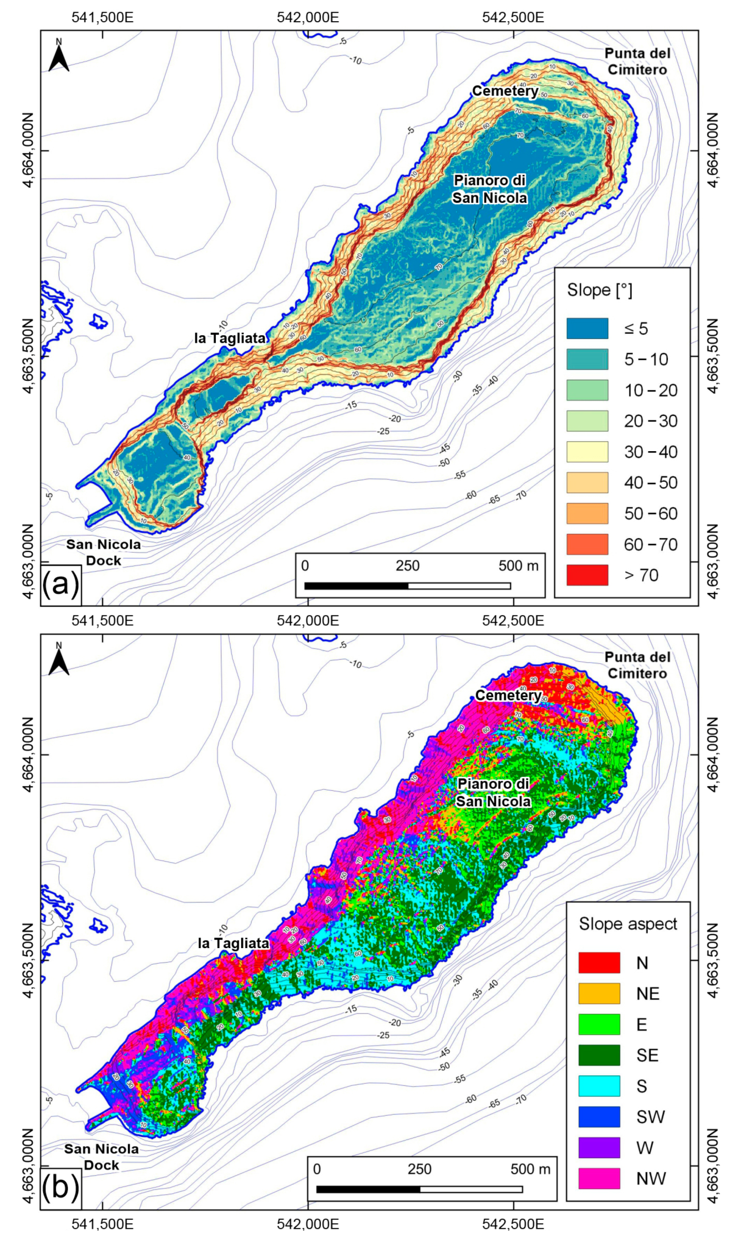
4.1. Geothematic Parameters

4.1.1. Photolineaments

The multitemporal stereoscopic analysis of available aerial photos covering the period 1955–2019 allowed us to detect the main photolineaments of the area, which served as a basis for the subsequent field surveying. The island presents an overall tabular morphology, with high flat sectors bordered by almost continuous sub-vertical cliffs (not portrayed in Figure 3 for the sake of image clarity). Detected and mapped features are represented by inner scarps and trenches. Concerning the former, a steep NW–SE-oriented scarp is clearly visible SW of la Tagliata. Other scarps visible in all aerial acquisitions are found in Punta del Cimitero, with W–E direction and demarcating sub-horizontal surfaces set at progressively lower elevations moving towards north.
Other elements are, finally, visible in the eastern sector of Pianoro di San Nicola a few meters inland, with respect to the main cliffs of the island. Concerning trenches, they show a main SW–NE direction and are found in the northwestern sector of Pianoro di San Nicola and NE of la Tagliata, along the southern border of the summit tabular surface.
Finally, urbanized sectors are mostly found in the southwestern sector of the island and do not display significant variations over the analyzed period.

4.1.2. Morphometric Features

From a morphometric perspective, the island features an elongated shape with a SW–NE directed major axis of about 1600 m and a width ranging approximately between 130 and 420 m, respectively measured in correspondence of la Tagliata and the northern portion of Pianoro di San Nicola. The coast extends for a total length of 3700 m and the maximum elevation is around 76 m a.s.l.
Two main flat sectors constitute its summit surface, meanly set at 43 (the southwestern one) and 75 (the northeastern one) m a.s.l., with slope values generally lower than 10°; they are separated by the NW–SE-oriented scarp already detected in the aerial photo interpretation and located SW of la Tagliata. This element features slope values greater than 60°, as do cliffs bordering the high sectors as well as the W–E-directed scarps found in Punta del Cimitero. Sectors with slope gradients ranging between 20° and 60°, finally, connect summit surfaces to the coastal areas (Figure 4a).
Concerning slope aspect values, they appear organized in SW–NE directed patches. The northwestern slopes meanly feature NW dipping; southwestern ones a dipping mostly varying between S and SE. The Punta del Cimitero area, on the other hand, shows an average N slope aspect, although S- or SW-dipping narrow sectors are present, which develop parallel to the main and continuous scarps. Within Pianoro di San Nicola, the slope aspect values feature a high variability, even if small SW–NE-directed sectors with N, NW, or W dipping are visible (Figure 4b).

4.1.3. Geomorphological Features

From a lithological point of view, the island is composed by a Cenozoic succession of marine origin, consisting of gently SE-dipping marls with local high fossiliferous content which are unconformably overlain by dolomitic limestones (Figure 5). Superficial deposits consist of reddish breccias and conglomerates organized in 0.25 m thick layers, outcropping on the southwestern slope of the island and lying on the marly deposits with erosive contact (Figure 5a); eluvial colluvial deposits, found on flat or gently dipping summit sectors; sandy shore deposits, present only in the surrounding areas of the San Nicola Dock; rockfall deposits, made up of decimeter- to meter-sized blocks of marly or dolomitic limestone lithology, broadly found along island coastal sectors and often covering sloping marly sectors (Figure 5b); and anthropic deposits.
Tectonic features are represented by several faults which are meanly NW–SE directed, cutting both marly and dolomitic limestone deposits. The main element is constituted by a normal fault detected in the southern sector, of which past activity resulted in a difference of elevations between the southwestern and northeastern high topographic sectors. Other faults are visible in the same area, cutting marly units overlain by breccias and conglomerate deposits and mostly featuring NE dipping, and along the slopes bordering Pianoro di San Nicola.
From a geomorphological viewpoint, detected and mapped elements mainly refer to slope, structural, and anthropic features (Figure 5).
Slope elements consist of emerged and submerged landslide bodies and related scarps, landslide terraces, trenches, counterslopes, and isolated blocks. Landslide bodies, referring to rockfall and topples, widely cover the Pianoro di San Nicola slopes, often burying underlying marly deposits, especially in the southeastern sector. The Punta del Cimitero area, on the other hand, presents a wide and complex gravitational phenomenon, with E–W-directed landslide terraces bordered by steep scarps and featuring elevations which get progressively lower moving towards the north, with a constant difference of about 15 m (Figure 6a). Unstable blocks of dolomitic limestone lithology are often found along terrace borders (Figure 6b). Other slope scarps border the southwestern summit surface, with heights greater than 10 m. Two main trenches are detected in the Pianoro di San Nicola area (Figure 6c,d), of which the former is found east of la Tagliata, along the southern cliff. It develops in the SW–NE direction, with depth values ranging from 6 to 9 m and an opening of about 2 m. Different sub-vertical fracture systems affect the rocky mass, with SW–NE or E–W directions and openings up to 15–25 cm. Several counterslopes, finally, are present in the southeastern sector of the Pianoro di San Nicola.
Structural landforms are mainly represented by scarps, among which the NW–SE-directed ones separate the summit flat surfaces and those partially bordering the urbanized sectors. Anthropic elements, finally, are represented by landslide and coastal defense works and by anthropic caves located under the northeastern inhabited sector and along the southern slope immediately east of la Tagliata (Figure 6e).
From a geomechanical viewpoint, rock discontinuities feature different densities and distributions in the area, with variable directions and openings from null to tens of centimeters. N60W- and N60E-oriented systems are the most present, widely affecting dolomitic limestones nearby island cliffs and, to a lesser extent, the inner sectors of Pianoro di San Nicola. W-E-directed fractures are mainly detected south of the Punta del Cimitero area. A N–S oriented system, finally, is present but much less represented compared to the others (Figure 7a).
Concerning density values, the inner Pianoro di San Nicola shows meanly “Very low” values, as does the southwestern inhabited sector. “Low” to “Medium” values, on the other hand, are mainly found near high tabular sector edges, secondarily in NW–SE elongated patches set in tectonic lineaments. “High” and “Very high” classes, finally, are spotted in the southern sector of Pianoro di San Nicola, east of la Tagliata, and in small sectors along its eastern and western borders and on the northwestern side of the urbanized sector (Figure 7a).
Concerning landslide scarps and anthropic caves (Figure 7b), the former border almost the whole Pianoro di San Nicola and partially the northwestern and northeastern sectors of the southern urbanized area, while the latter show the distribution already depicted in Figure 5.

4.2. Rockfall Susceptibility Map

The distribution of rockfall susceptibility classes derived using morphometric and geothematic parameters, reported in Table 1, is shown in Figure 8.
The “Very low” class accounts for about 3% of the territory and is well represented in flat sectors distributed all along the coastline, where mostly rockfall deposits outcrop, and in the western part of the urbanized sector. “Low” values are the most present ones, characterizing around the 67% of the whole area, and are mainly found in flat areas, including the terraced ones in the Punta del Cimitero area; low-susceptibility sectors are also widely present in sloping sectors bordering the island, where marly deposits locally covered by fallen limestone blocks outcrop. Medium values are spotted in island sloping flanks, near the edge of summit tabular areas and along E–W-oriented scarps found in the Punta del Cimitero area and bordering the terraced sectors; they constitute up to the 20% of analyzed sectors. High values tend to match with landslide scarps bordering high flat surfaces almost continuously; they represent about 10% of the island surface. Very-high-susceptibility sectors, finally, account only for 0.5% of the total; they feature the highest potential instability within the study area and are mainly identified in dolomitic outcrops with a high fracturing density. In detail, very-high-susceptibility sectors are detected east of la Tagliata, where stereoscopic aerial photo analyses and field surveys pointed out the presence of wide trenches, extensive and pervasive fracture systems, along with anthropic caves carved in the marly deposits. Other very-high-susceptibility sectors are located along the southeastern border of Pianoro di San Nicola, which are also characterized by counterslopes and diffuse fracturing. The northwestern flank of the island, on the other hand, features very high values only in small sectors north of la Tagliata and of the northwestern inhabited sector.

5. Discussions

In this work, different geothematic data were collected and analyzed to discover a new zonation of rockfall susceptibility for San Nicola Island, identifying five classes (Very low, Low, Medium, High, and Very high). The spatial distribution of rockfall susceptibility was carried out in a GIS environment following a stepwise approach, based on either direct (geomorphological field mapping) or indirect (photogeology and GIS data processing) analyses.
The performed investigations also allowed us to derive a comprehensive overview of geological and geomorphological features of the study area, which is severely affected by cliff retreat and gravitational phenomena, as shown by [14,37,39,52]. In detail, by combining multitemporal stereoscopic aerial photo interpretations, geomorphological field surveys, and geomechanical characterization of rock masses, it was possible to discriminate the main critical areas all over the island, in good accordance with historical data available from the literature for the study area. Some sectors characterized by medium-to-high values of rockfall susceptibility correspond to those where a major retreat of the coastal cliff has occurred historically, such as the area east of la Tagliata. This instability condition could be confirmed by damage to landscape features; here, in recent times, landslide movements have led to the destruction of the road network which connected the human settlement with the northeastern portion of the island, as shown in Figure 9a–c [4,13,52]. The same sector, along with most of the southeastern portion of Pianoro di San Nicola, features slope landforms such as trenches, scarps systems, and counterslopes, which testify to ongoing geomorphological processes (Figure 5); these are also pointed out by the spatial distribution of rockfall susceptibility, with values ranging from Medium to Very High along the main slope scarps.
Generally, the island features an active and dynamic landscape marked by significant sudden and localized slope instability processes (mainly rockfalls), as confirmed by geomorphological field surveys (Figure 6) and achieved rockfall susceptibility zonation (Figure 8). In this context, the analysis performed on Permanent Scatterers (PSs) data revealed an overall stability condition all along the island, without suggesting the presence of areas affected by slow-moving slope deformations. Only a few points, indicative of potential mass movements, were found in areas with a high/very high structural discontinuities density or along island edges in proximity of landslide scarps and anthropic caves. Consequently, these data were not used in the computation of susceptibility values so as to not overestimate a slopes’ tendency to fail, avoiding redundancies and overlapping effects which would be difficult to discriminate. From a geomorphological point of view, the landslide phenomena detected through field surveys present failure mechanisms ranging from lateral spreading, rockfall/topple, to rotational sliding in close connection with the tectonic and litho-structural setting of the area. In fact, marly deposits tend to deform plastically, inducing the growth of shear or tensile fractures within the overlying dolomitic units, which distinctly exhibit brittle behavior as a consequence of the different rheology. Furthermore, they are affected by intense erosion phenomena due to wind or marine spray action, although fallen blocks locally form natural reefs which represent effective barriers against excavation processes acting at the base of slopes. In this context, slope phenomena are due to the detachment and sliding of dolomitic blocks, of meter to decameter size, isolated by intersecting fracture systems. Similar contexts are found in the insular environments of Malta [76,77,78] and Mallorca [79], where the landscape results from the interplay of tectonics, slope processes, and marine action. This situation is comparable with the geomorphological dynamics of San Nicola Island. It is clearly evident in the southern sector of the Pianoro di San Nicola, east of la Tagliata, where the slope evolution has produced a wide trench, as above described. In terms of susceptibility, the highest values are indeed detected in heavily fractured dolomitic limestone, which is mostly found near island edges where marly layer deformation occurs more easily due to lateral unconfinement.
To better discriminate the triggering mechanisms of some of the detected landslide movements and to derive the role played by the main litho-structural and tectonic features, seismic features of San Nicola Island were taken into account. According to the geological and tectonic context of the area, seismic loading can contribute to the general slope instability, either by reducing the strength of rock masses by propagation and widening of present fractures, or by triggering rockfall and topple phenomena [80]. According to the DBMI15 v4.0 catalogue [59], indeed, San Nicola Island has suffered shaking produced by several earthquakes, starting from the XVII century and affecting both the Gargano and Southern Adriatic areas (Figure 10).
The first of them, the Capitanata event (30 July 1627 Mw = 6.66), enucleated in the Gargano area, producing damage assessed as VII–VIII degree on the MCS scale on San Nicola Island and also being responsible for a major tsunami event [52]. After this, the island underwent even greater seismic intensities due to the Gargano (31 May 1646, Mw = 6.72) and the Molise coast (22 November 1821, Mw = 5.59) events. More recently, the area suffered shaking produced by earthquakes which occurred in the Gargano promontory (e.g., the Gargano earthquake, 8 December 1889, Mw = 5.47) or at the archipelago, where low magnitudes can result into severe ground motion (e.g., the Isole Tremiti earthquake, 6 June 1892, Mw = 4.88). Finally, according to the ISIDe database, the area has recently been subject to seismic events occurring in neighboring areas with on-shore and off-shore epicenters (e.g., the Central Adriatic earthquake, 27 March 2021, Mw = 5.2). In this context, a comparison between the 2019 AGEA orthophotos of the southern sector of the Pianoro di San Nicola and a high-resolution drone image of the same area acquired in summer 2022 reveals the mobilization of some meter-sized blocks and their transit area from the detachment to the deposition zones (Figure 11a,b). As during the same time interval the area suffered seismic shaking produced by the Central Adriatic earthquake, it is reasonable that this movement was induced by this event; although, an initiation due to heavy meteoric events cannot a priori be excluded. Furthermore, new rockfalls occurred after the earthquake which took place off the Tremiti Islands on 21 June 2023 (Mw = 4.2, Figure 11c).
In addition, the synthesis of all collected data allowed us to reconstruct the geomorphological evolution of Punta del Cimitero. Starting from the results of field surveys, a schematic and qualitative representation of inferred evolutionary stages is reported in Figure 12, corresponding to the SSW–NNE portion of the geomorphological cross-section in Figure 5. The area appears to be affected by a slowly evolving complex landslide movement, which is characterized by the presence of at least three sub-parallel rotational sliding surfaces with approximately an E–W direction. At present, the sector not affected by slope deformations shows a sub-horizontal geometry, the slope terrace located at the highest elevation shows exposure partially towards the south, and terraces located at lower elevations show an exposure markedly towards the north. Given the rotational component of the landslide movement affecting the different blocks, it is possible to infer that originally the outermost sector showed a greater northward dipping compared to the present, while the intermediate sector between the present landslide body and the stable area was sub-planar, perhaps weakly north dipping. These observations agree with those proposed by [52], according to which the structure of San Nicola Island can be approximated to an anticline, of which the Cemetery area represents a slightly sloping flank.
Finally, the combination and overlapping of gathered data (geothematic parameters and spatial distribution of rockfall susceptibility) allowed us to preliminarily highlight the interplay between the litho-structural/geological framework and landslide dynamics of San Nicola Island. It is possible to infer that sectors with a higher susceptibility are those in which the tectonic control prevails over the litho-structural one, so that the evolution of the landscape is driven by sudden gravitational phenomena such as rockfalls and topples. Iin this context, the shaking produced by earthquakes that enucleate in the area or in neighboring regions represents a triggering factor but also a strongly predisposing parameter, given the weakening action exerted on rock masses. In areas where the susceptibility is lower, on the other hand, the litho-structural control prevails and the landscape evolution is markedly slower.

6. Conclusions

San Nicola Island features a dynamic landscape, where short- and long-term evolution is strictly connected to geomorphological processes mainly acting on its steep slopes and cliffs. In this work, the detection and classification of areas most prone to collapse was carried out following a multidisciplinary approach. It involved data gathered through multitemporal stereoscopic aerial photo analyses (1:33,000 to 1:5000 scale), morphometric analyses (from 2 m resolution DTM), and geomorphological field mapping (1:2500 scale).
A rockfall susceptibility map was created combining morphometric and geothematic parameters (i.e., slope, slope aspect, outcropping lithologies, structural discontinuities density, distance from landslide scarps, and presence of anthropic caves) through a heuristic approach. The spatial distribution of rockfall susceptibility in the study area was then defined, identifying five classes marking Very low, Low, Medium, High, and Very high rockfall susceptibility. The resulting data were integrated with seismic data and historical maps to highlight variations in natural and anthropic landscape features within the wider geomorphological and seismotectonic contexts.
In San Nicola Island, landscape modifications mainly occur suddenly through rockfalls and topples in response to impulsive triggering events such as strong earthquakes, as documented and testified by the recent seismicity. Moreover, a comparison between data reported in [52] and those derived through field surveys results in an increase of about 4% in landslide affected areas (from 20.8 to 25.1%), which is likely linked to seismic events which occurred between the late 90s and the present day. Remarkably, major increments are detected in those areas featuring the highest susceptibility values; areas with “Low” to “Medium” rockfall susceptibility, such as the Cemetery one, show no significant variations.
In conclusion, the presented results are meant as an overall representation of areas with different susceptibility levels to rockfalls and as a predictor of related landslide hazards at specific sites. In particular, it allowed us to produce a new zonation of rockfall susceptibility for San Nicola Island, together with defining and mapping critical areas all over the island. In this context, the outcomes of this research outline the importance of geomorphological field mapping in the rockfall susceptibility assessment of the island, as well as in the evaluation of the overall accuracy of results. In detail, field activities allowed us to produce an updated and detailed geomorphological map which is helpful for depicting the spatial distribution of rockfalls for proper parameter selection and weighting and for deriving insights about the geomorphological evolution.
For San Nicola Island, given the well-known seismicity of the area and accounting for climate change and the potential occurrence of extreme weather events, risk mitigation measures should ultimately be adopted to reduce rockfall-related hazards and risks. Sectors showing a major propensity to fail should be the subject of consolidation and ongoing monitoring activities; the creation of buffer zones at their base with bathing prohibition would also be advisable for people’s safety.
Finally, this work presents a scientific and methodological approach that could be effectively applied in any other small insular areas, showing comparable geological–geomorphological features and landscape values, to support landslide hazard assessments and proper territorial planning.

Author Contributions

Conceptualization, E.M.; methodology, J.C., V.P. and G.P.; validation, E.M.; investigation, J.C., V.P., G.P., A.S. and E.M.; data curation, J.C., V.P. and A.S.; writing—original draft preparation, V.P. and J.C.; writing—review and editing, J.C. and G.P.; visualization, F.C.; supervision, E.M.; project administration, E.M.; funding acquisition, E.M. All authors have read and agreed to the published version of the manuscript.

Funding

This work was supported by the Department of Engineering and Geology, Università degli Studi ‘G. d’Annunzio’ Chieti-Pescara funds (E. Miccadei University fund).

Data Availability Statement

Data supporting the findings of this study are available from the corresponding author upon reasonable request. Data are not publicly available due to privacy. Images employed for the study will be available online for readers.

Acknowledgments

The authors thank the Cartographic Office of the Puglia Region for the material available at the Territorial Information System Portal (http://www.sit.puglia.it. accessed on 12 June 2023), the Istituto Geografico Militare (IGM) and the Agenzia per le Erogazioni in Agricoltura (AGEA) for providing stereo image pairs, and the Italian Ministero dell’Ambiente e della Sicurezza Energetica for providing the LiDAR data used in this study. The authors are grateful to the anonymous reviewers for their critical review of the paper and their precious suggestions, which significantly improved this manuscript.

Conflicts of Interest

The authors declare no conflict of interest.

References

  1. Festa, V.; Teofilo, G.; Tropeano, M.; Sabato, L.; Spalluto, L. New Insights on Diapirism in the Adriatic Sea: The Tremiti Salt Structure (Apulia Offshore, Southeastern Italy). Terra Nova 2014, 26, 169–178. [Google Scholar] [CrossRef]
  2. Teofilo, G.; Festa, V.; Sabato, L.; Spalluto, L.; Tropeano, M. 3D Modelling of the Tremiti Salt Diapir in the Gargano Offshore (Adriatic Sea, Southern Italy): Constraints in the Tremiti Structure Development. Ital. J. Geosci. 2016, 135, 474–485. [Google Scholar] [CrossRef]
  3. Mastronuzzi, G.; Sansò, P. Holocene Uplift Rates and Historical Rapid Sea-level Changes at the Gargano Promontory, Italy. J. Quat. Sci. 2002, 17, 593–606. [Google Scholar] [CrossRef]
  4. Cocarella, B. Cronica Istoriale di Tremiti; Giovanni Battista Colosino: Venezia, Italy, 1606. [Google Scholar]
  5. Ceva-Grimaldi, F. Memorie Storiche delle Isole e Badia di Tremiti; Stabilimento tipografico L’Araldo: Napoli, Italy, 1852. [Google Scholar]
  6. Tellini, A. Osservazioni Geologiche Sulle Isole Tremiti e Sull’Isola di Pianosa Nell’Adriatico. Boll. R. Com. Geol. D’italia 1890, 21, 442–514. [Google Scholar]
  7. Dell’Aquila, V. Cenni Storici Sulle Isole Di Tremiti Nei Rapporti Amministrativi e Giudiziari; Stamperia Editrice Frattarolo: Lucera, Italy, 1908. [Google Scholar]
  8. Squinabol, S. Riassunto di uno Studio Geofisico Sulle Tremiti. Atti. della R. Accad. delle Sci. di Torino 1908, 43, 1008–1013. [Google Scholar]
  9. Zorzi, F. Tremiti. Riv. di Sci. Preist. 1958, 13, 208–209. [Google Scholar]
  10. Checchia Rispoli, G. Osservazioni Geologiche Sull’Isola di S. Nicola di Tremiti (Mare Adriatico). Boll. R. Uff. Geol. Ital. 1926, 51, 1–3. [Google Scholar]
  11. Baldacci, O. Ricerche Geografiche Sulle IsoleTremiti. Boll. Soc. Geogr. Ital. 1953, 8, 341–410. [Google Scholar]
  12. Fumo, P. La Preistoria delle Isole Tremiti: Il Neolitico; Enne: Ferrazzano, Italy, 1980; ISBN 8872130832. [Google Scholar]
  13. Radicchio, G. L’Isola di San Nicola di Tremiti; Palomar: Bari, Italy, 1993. [Google Scholar]
  14. Lollino, P.; Pagliarulo, R. The Interplay of Erosion, Instability Processes and Cultural Heritage at San Nicola Island (Tremiti Archipelago, Southern Italy). Geogr. Fis. Din. Quat. 2008, 31, 161–169. [Google Scholar]
  15. Iadanza, C.; Trigila, A.; Vittori, E.; Serva, L. Landslides in Coastal Areas of Italy. Geol. Soc. Lond. Spec. Publ. 2009, 322, 121–141. [Google Scholar] [CrossRef]
  16. Varnes, D.J. Landslide Hazard Zonation: A Review of Principles and Practice; Natural Hazards, 3; UNESCO: Paris, France, 1984. [Google Scholar]
  17. Guzzetti, F.; Carrara, A.; Cardinali, M.; Reichenbach, P. Landslide Hazard Evaluation: A Review of Current Techniques and Their Application in a Multi-Scale Study, Central Italy. Geomorphology 1999, 31, 181–216. [Google Scholar] [CrossRef]
  18. van Westen, C.J.; van Asch, T.W.J.; Soeters, R. Landslide Hazard and Risk Zonation—Why Is It Still so Difficult? Bull. Eng. Geol. Environ. 2006, 65, 167–184. [Google Scholar] [CrossRef]
  19. Merghadi, A.; Yunus, A.P.; Dou, J.; Whiteley, J.; Thaipham, B.; Bui, T.; Avtar, R.; Boumezbeur, A. Machine learning methods for landslide susceptibility studies: A comparative overview of algorithm performance. Earth Sci. Rev. 2020, 207, 103225. [Google Scholar] [CrossRef]
  20. Dong, A.; Dou, J.; Fu, Y.; Zhang, R.; Xing, K. Unraveling the evolution of landslide susceptibility: A systematic review of 30-years of strategic themes and trends. Geocarto Int. 2023, 38, 2256308. [Google Scholar] [CrossRef]
  21. Ruff, M.; Czurda, K. Landslide Susceptibility Analysis with a Heuristic Approach in the Eastern Alps (Vorarlberg, Austria). Geomorphology 2008, 94, 314–324. [Google Scholar] [CrossRef]
  22. Leoni, G.; Campolo, D.; Falconi, L.; Gioè, C.; Lumaca, S.; Puglisi, C.; Torre, A. Heuristic Method for Landslide Susceptibility Assessment in the Messina Municipality. In Engineering Geology for Society and Territory; Lollino, G., Giordan, D., Crosta, G.B., Corominas, J., Azzam, R., Wasowski, J., Sciarra, N., Eds.; Springer: Cham, Switzerland, 2015; Volume 2. [Google Scholar] [CrossRef]
  23. Carabella, C.; Cinosi, J.; Piattelli, V.; Burrato, P.; Miccadei, E. Earthquake-Induced Landslides Susceptibility Evaluation: A Case Study from the Abruzzo Region (Central Italy). Catena 2022, 208, 105729. [Google Scholar] [CrossRef]
  24. Reichenbach, P.; Rossi, M.; Malamud, B.D.; Mihir, M.; Guzzetti, F. A Review of Statistically-Based Landslide Susceptibility Models. Earth Sci. Rev. 2018, 180, 60–91. [Google Scholar] [CrossRef]
  25. Xu, C. Preparation of earthquake-triggered landslide inventory maps using remote sensing and GIS technologies: Principles and case studies. Geosci. Front. 2015, 6, 825–836. [Google Scholar] [CrossRef]
  26. Frattini, P.; Crosta, G.; Carrara, A.; Agliardi, F. Assessment of rockfall susceptibility by integrating statistical and physically-based approaches. Geomorphology 2008, 94, 419–437. [Google Scholar] [CrossRef]
  27. Briones-Bitar, J.; Carrión-Mero, P.; Montalván-Burbano, N.; Morante-Carballo, F. Rockfall Research: A Bibliometric Analysis and Future Trends. Geosciences 2020, 10, 403. [Google Scholar] [CrossRef]
  28. Alvioli, M.; Santangelo, M.; Fiorucci, F.; Cardinali, M.; Marchesini, I.; Reichenbach, P.; Rossi, M.; Guzzetti, F.; Peruccacci, S. Rockfall Susceptibility and Network-Ranked Susceptibility along the Italian Railway. Eng. Geol. 2021, 293, 106301. [Google Scholar] [CrossRef]
  29. Toševski, A.; Pollak, D.; Perković, D. Identification of Rockfall Source Areas Using the Seed Cell Concept and Bivariate Susceptibility Modelling. Bull. Eng. Geol. Environ. 2021, 80, 7551–7576. [Google Scholar] [CrossRef]
  30. Cignetti, M.; Godone, D.; Bertolo, D.; Paganone, M.; Thuegaz, P.; Giordan, D. Rockfall susceptibility along the regional road network of Aosta Valley Region (northwestern Italy). J. Maps 2021, 17, 54–64. [Google Scholar] [CrossRef]
  31. Wen, H.; Hu, J.; Zhang, J.; Xiang, X.; Liao, M. Rockfall Susceptibility Mapping Using XGBoost Model by Hybrid Optimized Factor Screening and Hyperparameter. Geocarto. Int. 2022, 37, 16872–16899. [Google Scholar] [CrossRef]
  32. Bajni, G.; Camera, C.A.S.; Apuani, T. A Novel Dynamic Rockfall Susceptibility Model Including Precipitation, Temperature and Snowmelt Predictors: A Case Study in Aosta Valley (Northern Italy). Landslides 2023, 20, 2131–2154. [Google Scholar] [CrossRef]
  33. APAT. Rapporto Sulle Frane in Italia–Il Progetto IFFI: Metodologia, Risultati e Rapporti Regionali; Report 78/2007; APAT: Rome, Italy, 2007. [Google Scholar]
  34. Fortunato, C.; Martino, S.; Prestininzi, A.; Romeo, R.W. New Release of the Italian Catalogue of Earthquake-Induced Ground Failures (CEDIT). Ital. J. Eng. Geol. Environ. 2012, 2, 63–74. [Google Scholar] [CrossRef]
  35. Caprari, P.; Della Seta, M.; Martino, S.; Fantini, A.; Fiorucci, M.; Priore, T. Upgrade of the Cedit Database of Earthquake-Induced Ground Effects in Italy. Ital. J. Eng. Geol. Environ. 2018, 18, 23–39. [Google Scholar] [CrossRef]
  36. Audemard, F.; Azuma, T.; Baiocco, F.; Baize, S.; Blumetti, A.M.; Brustia, E.; Clague, J.; Comerci, V.; Esposito, E.; Guerrieri, L.; et al. Earthquake Environmental Effect for Seismic Hazard Assessment: The ESI Intensity Scale and the EEE Catalogue. Memorie Descrittive della Carta Geologica d’Italia; Guerrieri, L., Ed.; Servizio Geologico d’Italia, Istituto Superiore per la Protezione e la Ricerca Ambientale (ISPRA): Rome, Italy, 2015; Volume 97, 182p. [Google Scholar] [CrossRef]
  37. Miccadei, E.; Orrù, P.; Piacentini, T.; Mascioli, F.; Puliga, G. Geomorphological Map of the Tremiti Islands (Puglia, Southern Adriatic Sea, Italy), Scale 1:15,000. J. Maps 2012, 8, 74–87. [Google Scholar] [CrossRef]
  38. Buccolini, M.; Carabella, C.; Paglia, G.; Cecili, A.; Chiarolanza, G.; Cioria, C.; Conicella, C.; D’Alonzo, A.; De Viti, L.; Di Carlo, F.; et al. Geomorphological Analysis of the San Domino Island (Tremiti Islands, Southern Adriatic Sea). Results from the 2019 Geomorphological Field Camp of the MSc in Geological Science and Technology (University of Chieti-Pescara). J. Maps 2020, 16, 10–18. [Google Scholar] [CrossRef]
  39. Piattelli, V.; Cinosi, J.; Esposito, G.; Mancinelli, V.; Paglia, G.; Ciaglia, S.; Colasante, P.; Defilippis, D.; de Iure, F.; Desiderio, S.; et al. Geomorphological Analysis of San Nicola Island (Tremiti Islands, Southern Adriatic Sea). Results from the 2021 and 2022 Environmental Geomorphology Field Camps of the MSc in Geological Sciences and Technologies of Earth and Planets (University ‘G. d’Annunzio’ of Chieti-Pescara). J. Maps 2023, 19, 2164748. [Google Scholar] [CrossRef]
  40. Selli, R. Isole Tremiti e Pianosa. In Note Illustrative della Carta Geologica d’Italia alla Scala 1:100,000 Foglio 156 “S. Marco in Lamis”; Cremonini, G., Elmi, C., Selli, R., Eds.; Servizio Geologico d’Italia: Rome, Italy, 1971. [Google Scholar]
  41. Andriani, G.F.; Walsh, N.; Pagliarulo, R. The Influence of the Geological Setting on the Morphogenetic Evolution of the Tremiti Archipelago (Apulia, Southeastern Italy). Nat. Hazards Earth Syst. Sci. 2005, 5, 29–41. [Google Scholar] [CrossRef]
  42. Miccadei, E.; Mascioli, F.; Piacentini, T. Quaternary Geomorphological Evolution of the Tremiti Islands (Puglia, Italy). Quat. Int. 2011, 233, 3–15. [Google Scholar] [CrossRef]
  43. Favali, P.; Funiciello, R.; Mattietti, G.; Mele, G.; Salvini, F. An Active Margin across the Adriatic Sea (Central Mediterranean Sea). Tectonophysics 1993, 219, 109–117. [Google Scholar] [CrossRef]
  44. Del Gaudio, V.; Pierri, P.; Frepoli, A.; Calcagnile, G.; Venisti, N.; Cimini, G.B. A Critical Revision of the Seismicity of Northern Apulia (Adriatic Microplate—Southern Italy) and Implicationsfor the Identification of Seismogenic Structures. Tectonophysics 2007, 436, 9–35. [Google Scholar] [CrossRef]
  45. Di Bucci, D.; Ravaglia, A.; Seno, S.; Toscani, G.; Fracassi, U.; Valensise, G. Modes of Fault Reactivation from Analogue Modeling Experiments: Implications for the Seismotectonics of the Southern Adriatic Foreland (Italy). Quat. Int. 2007, 171–172, 2–13. [Google Scholar] [CrossRef]
  46. Miccadei, E.; Carabella, C.; Paglia, G. Morphoneotectonics of the Abruzzo Periadriatic Area (Central Italy): Morphometric Analysis and Morphological Evidence of Tectonics Features. Geosciences 2021, 11, 397. [Google Scholar] [CrossRef]
  47. Rovida, A.; Locati, M.; Camassi, R.; Lolli, R.; Gasperini, P.; Antonucci, A. Catalogo Parametrico dei Terremoti Italiani (CPTI15), Versione 4.0.; Istituto Nazionale di Geofisica e Vulcanologia (INGV): Rome, Italy, 2022. [Google Scholar] [CrossRef]
  48. Andriani, G.F.; Guerricchio, A. Caratteri Litostratigrafico-Tessiturali e Geomeccanici Delle Rocce Affioranti Nell’Isola Di S. Nicola (Isole Tremiti). Geol. Appl. E Idrogeol. 1996, 31, 97–105. [Google Scholar]
  49. Ridente, D.; Trincardi, F. Eustatic and Tectonic Control on Deposition and Lateral Variability of Quaternary Regressive Sequences in the Adriatic Basin (Italy). Mar. Geol. 2002, 184, 273–293. [Google Scholar] [CrossRef]
  50. Parlagreco, L.; Mascioli, F.; Miccadei, E.; Antonioli, F.; Gianolla, D.; Devoti, S.; Leoni, G.; Silenzi, S. New Data on Holocene Relative Sea Level along the Abruzzo Coast (Central Adriatic, Italy). Quat. Int. 2011, 232, 179–186. [Google Scholar] [CrossRef]
  51. Romano, E.; Bergamin, L.; Berto, D.; Chiocci, F.L.; Miccadei, E.; Paglia, G.; Piattelli, V.; Pierfranceschi, G.; Rampazzo, F.; Sorci, A.; et al. Geomorphological, Sedimentological, and Ecological Characterization of Marine Caves from Capraia Island (Tremiti Archipelago, Southern Adriatic Sea, Italy): An Integrated Approach. Mar. Geol. 2023, 455, 106952. [Google Scholar] [CrossRef]
  52. Cotecchia, V.; Guerricchio, A.; Melidoro, G. Geologia e Processi di Demolizione Costiera Dell’isola di S. Nicola (Tremiti). Mem. Soc. Geol. Ital. 1996, 51, 595–606. [Google Scholar]
  53. Coco, L.; Buccolini, M. The Effect of Morphometry, Land-Use and Lithology on Landslides Susceptibility: An Exploratory Analysis. In Geotechnical Safety and Risk V; IOS Press: Amsterdam, The Netherlands, 2015; pp. 779–784. [Google Scholar]
  54. ISPRA. Guida Alla Rappresentazione Cartografica della Carta Geomorfologica d’Italia in Scala 1:50,000; Quaderni Serie III; ISPRA: Rome, Italy, 2007. [Google Scholar]
  55. Smith, M.J.; Paron, P.; Griffiths, J.S. Geomorphological Mapping: Methods and Applications; Shroder, J.F., Ed.; Elsevier: Amsterdam, The Netherlands, 2011; Volume 15. [Google Scholar]
  56. Seijmonsbergen, A.C. The Modern Geomorphological Map. In Treatise on Geomorphology; Elsevier: Amsterdam, The Netherlands, 2013; pp. 35–52. [Google Scholar]
  57. Ciccacci, S.; D’Alessandro, L.; Dramis, F.; Miccadei, E. Geomorphologic evolution and neotectonics of the Sulmona intramontane basin (Abruzzi Apennine, Central Italy). Z. Für Geomorphol. 1999, 118, 27–40. [Google Scholar]
  58. Mantovani, M.; Devoto, S.; Piacentini, D.; Prampolini, M.; Soldati, M.; Pasuto, A. Advanced SAR Interferometric Analysis to Support Geomorphological Interpretation of Slow-Moving Coastal Landslides (Malta, Mediterranean Sea). Remote Sens. 2016, 8, 443. [Google Scholar] [CrossRef]
  59. Locati, M.; Camassi, R.; Rovida, A.; Ercolani, E.; Bernardini, F.; Castelli, V.; Caracciolo, C.; Tertulliani, A.; Rossi, A.; Azzaro, R.; et al. Database Macrosismico Italiano (DBMI15)–Versione 4.0; Istituto Nazionale di Geofisica e Vulcanologia (INGV): Rome, Italy, 2022. [Google Scholar] [CrossRef]
  60. ISIDe Working Group, ISIDe Working Group Italian Seismological Instrumental and Parametric Database (ISIDe); Istituto Nazionale di Geofisica e Vulcanologia (INGV): Rome, Italy, 2007. [CrossRef]
  61. Gupta, R.P.; Saha, A.K.; Arora, M.K.; Kumar, A. Landslide Hazard Zonation in a Part of the Bhagirathi Valley, Garhwal Mimalyas, using integrated remote sensing–GIS. Himal. Geol. 1999, 20, 71–85. [Google Scholar]
  62. Çevik, E.; Topal, T. GIS-Based Landslide Susceptibility Mapping for a Problematic Segment of the Natural Gas Pipeline, Hendek (Turkey). Environ. Geol. 2003, 44, 949–962. [Google Scholar] [CrossRef]
  63. Yalcin, A.; Reis, S.; Aydinoglu, A.C.; Yomralioglu, T. A GIS-Based Comparative Study of Frequency Ratio, Analytical Hierarchy Process, Bivariate Statistics and Logistics Regression Methods for Landslide Susceptibility Mapping in Trabzon, NE Turkey. Catena 2011, 85, 274–287. [Google Scholar] [CrossRef]
  64. Marsala, V.; Galli, A.; Paglia, G.; Miccadei, E. Landslide Susceptibility Assessment of Mauritius Island (Indian Ocean). Geosciences 2019, 9, 493. [Google Scholar] [CrossRef]
  65. Montoya-Montes, I.; Rodríguez-Santalla, I.; Sánchez-García, M.J.; Alcántara-Carrió, J.; Martín-Velázquez, S.; Gómez-Ortiz, D.; Martín-Crespo, T. Mapping of Landslide Susceptibility of Coastal Cliffs: The Mont-Roig del Camp Case Study. Geol. Acta 2012, 10, 439–455. [Google Scholar]
  66. Anfuso, G.; Postacchini, M.; Di Luccio, D.; Benassai, G. Coastal Sensitivity/Vulnerability Characterization and Adaptation Strategies: A Review. J. Mar. Sci. Eng. 2021, 9, 72. [Google Scholar] [CrossRef]
  67. Katalinić, M.; Parunov, J. Comprehensive Wind and Wave Statistics and Extreme Values for Design and Analysis of Marine Structures in the Adriatic Sea. J. Mar. Sci. Eng. 2021, 9, 522. [Google Scholar] [CrossRef]
  68. Carrara, A.; Cardinali, M.; Detti, R.; Guzzetti, F.; Pasqui, V.; Reichenbach, P. GIS Techniques and Statistical Models in Evaluating Landslide Hazard. Earth Surf. Process Landf. 1991, 16, 427–445. [Google Scholar] [CrossRef]
  69. Esposito, G.; Carabella, C.; Paglia, G.; Miccadei, E. Relationships between Morphostructural/Geological Framework and Landslide Types: Historical Landslides in the Hilly Piedmont Area of Abruzzo Region (Central Italy). Land 2021, 10, 287. [Google Scholar] [CrossRef]
  70. Vanneschi, C.; Rindinella, A.; Salvini, R. Hazard Assessment of Rocky Slopes: An Integrated Photogrammetry–GIS Approach Including Fracture Density and Probability of Failure Data. Remote Sens. 2022, 14, 1438. [Google Scholar] [CrossRef]
  71. Piacentini, T.; Miccadei, E.; Di Michele, R.; Sciarra, N.; Mataloni, G. Geomorphological analysis applied to rock falls in Italy: The case of the San Venanzio gorges (Aterno river, Abruzzo, Italy). Ital. J. Eng. Geol. Environ. 2013, 6, 467–479. [Google Scholar] [CrossRef]
  72. Piacentini, D.; Devoto, S.; Mantovani, M.; Pasuto, A.; Prampolini, M.; Soldati, M. Landslide Susceptibility Modeling Assisted by Persistent Scatterers Interferometry (PSI): An Example from the Northwestern Coast of Malta. Nat. Hazards 2015, 78, 681–697. [Google Scholar] [CrossRef]
  73. Liguori, V.; Manno, G.; Placenti, V. Sinkholes Risk Analysis: Case History of Marsala (Sicily, Italy). In Proceedings of the Risk Analysis V: Simulation and Hazard Mitigation, Lisbonne, Portugal, 23–25 June 2020; WIT Press: Southampton, UK, 2006; pp. 107–118. [Google Scholar]
  74. Khatun, M.; Hossain, A.T.M.S.; Sayem, H.M.; Moniruzzaman, M.; Ahmed, Z.; Rahaman, K.R. Landslide Susceptibility Mapping Using Weighted-Overlay Approach in Rangamati, Bangladesh. Earth Syst. Environ. 2023, 7, 223–235. [Google Scholar] [CrossRef]
  75. Chalkias, C.; Polykretis, C.; Ferentinou, M.; Karymbalis, E. Integrating Expert Knowledge with Statistical Analysis for Landslide Susceptibility Assessment at Regional Scale. Geosciences 2016, 6, 14. [Google Scholar] [CrossRef]
  76. Magri, O.; Mantovani, M.; Pasuto, A.; Soldati, M. Geomorphological investigation and monitoring of lateral spreading along the north-west coast of Malta. Geogr. Fis. E Din. Quat. 2008, 31, 171–180. [Google Scholar]
  77. Soldati, M.; Devoto, S.; Prampolini, M.; Pasuto, A. The spectacular landslide-controlled landscape of the northwestern coast of Malta. In Landscapes and Landforms of the Maltese Islands; Springer: Cham, Switzerland, 2019; pp. 167–178. [Google Scholar] [CrossRef]
  78. Colica, E.; Galone, L.; D’Amico, S.; Gauci, A.; Iannucci, R.; Martino, S.; Pistillo, D.; Iregbeyen, P.; Valentino, G. Evaluating Characteristics of an Active Coastal Spreading Area Combining Geophysical Data with Satellite, Aerial, and Unmanned Aerial Vehicles Images. Remote Sens. 2023, 15, 1465. [Google Scholar] [CrossRef]
  79. Mateos, R.; Ezquerro, P.; Azañón, J.; Gelabert, B.; Herrera, G.; Fernández-Merodo, J.A.; Spizzichino, D.; Sarro, R.; García-Moreno, I.; Béjar-Pizarro, M. Coastal lateral spreading in the world heritage site of the Tramuntana Range (Majorca, Spain). The use of PSInSAR monitoring to identify vulnerability. Landslides 2018, 15, 797–809. [Google Scholar] [CrossRef]
  80. Zhang, X.; Zhang, Q.; Liu, Q.; Xiao, R. A Numerical Study of Wave Propagation and Cracking Processes in Rock-Like Material under Seismic Loading Based on the Bonded-Particle Model Approach. Engineering 2022, 17, 140–145. [Google Scholar] [CrossRef]
  81. DISS Working Group Database of Individual Seismogenic Sources (DISS). Version 3.3.0: A Compilation of Potential Sources for Earthquakes Larger than M 5.5 in Italy and Surrounding Areas; Istituto Nazionale di Geofisica e Vulcanologia (INGV): Rome, Italy, 2021. [Google Scholar] [CrossRef]
Figure 1. (a) Location map of Tremiti Islands in the Southern Adriatic Sea (Italy)—the red box identifies the location of Tremiti Islands; (b) 2019 orthophoto image of San Domino, San Nicola, Capraia, and Cretaccio Islands (Puglia Region, http://www.sit.puglia.it, accessed on 12 June 2023).
Geosciences 13 00352 g001
Figure 2. Flowchart of the applied methodology. Black boxes indicate used data, red boxes performed analyses, green boxes preliminary results used for rockfall susceptibility assessment, blue boxes final results.
Geosciences 13 00352 g002
Figure 3. Photolineaments derived through the multitemporal stereoscopic analysis of aerial photos of San Nicola Island referring to (a) 1955, (b) 1977, (c) 1996, and (d) 2019 flights. Coordinate system: WGS84 UTM Zone 33N.
Geosciences 13 00352 g003
Figure 4. Maps of the (a) slope and (b) slope aspect of San Nicola Island. The blue line indicates the coastline. Coordinate system: WGS84 UTM Zone 33N.
Geosciences 13 00352 g004
Figure 5. Geomorphological map and cross-section of San Nicola Island. Legend: (1) anthropic deposits, (2) landslide deposits, (3) eluvial–colluvial deposits, (4) sandy shore deposits, (5) submerged landslide deposits, (6) breccias and conglomerate levels, (7) dolomitic limestone deposits, (8) marls deposits, (9) fault, (10) inferred fault, (11) lithological boundary, dashed if inferred, (12) landslide surface, (13) bedding, (14) cross-section trace, (15) photo acquisition point, (16) structural scarp, (17) rockfall deposits, (18) rotational landslide, (19) landslide terraces, (20) slope scarp, height < 5 m, (21) slope scarp, 5 m < height < 10, (22) slope scarp, height > 10 m, (23) trench, (24) counterslope, (25) isolated block, (26) anthropic scarp, (27) coastal defense work, (28) landslide defense work. Photo documentation: (a) marly deposits unconformably overlain by reddish breccias and conglomerate layers in the southwestern sector of San Nicola Island; (b) example of rockfall deposits made of decimeter- to meter-sized rockfall deposits of dolomitic limestone lithology. The blue line indicates the coastline. Coordinate system: WGS84 UTM Zone 33N.
Geosciences 13 00352 g005
Figure 6. Photo documentation of geomorphological features of San Nicola Island: (a) landslide scarps, inferred sliding surfaces, and meter-sized fallen block detected in correspondence of Punta del Cimitero; (b) unstable meter-sized block of dolomitic limestone lithology detected in the Cemetery area—the position is indicated by the violet polygon in Figure (a); (c,d) deep trenches and rockfall deposits along the southern flank, east of la Tagliata, and the northwestern one of Pianoro di San Nicola; (e) anthropic cave carved into marly deposits. Legend: (1) structural scarp, (2) isolated block, (3) slope scarp, (4) trench.
Geosciences 13 00352 g006
Figure 7. Maps of (a) structural discontinuities density and (b) landslide scarps buffer (buffer zone of 10 m downward and 2 m landward) and anthropic caves buffer (buffer zone of 15 m around detected elements) of San Nicola Island. Stereographic projections in (a) depict fracture systems detected through geomechanical investigations or literature data analysis (red lines) and slope geometry (black line). The blue line indicates the coastline. Coordinate system: WGS84 UTM Zone 33N.
Geosciences 13 00352 g007
Figure 8. Rockfall susceptibility map of San Nicola Island. The blue line indicates the coastline. Coordinate system: WGS84 UTM Zone 33N.
Geosciences 13 00352 g008
Figure 9. Historical maps of Tremiti Islands attributed to: (a) Bonifacio Natale, 1567 [52]; (b) Cocarella Benedetto, 1606 [4]; (c) D. Bonifacius Ticin. S Mortar, 1670 [13].
Geosciences 13 00352 g009
Figure 10. (a) Hillshade of the Gargano area with main earthquakes derived from the CPTI15 v4.0 catalogue [47]—for seismic events that most affected the study area (red box), focal mechanisms derived from DISS database [81] are shown when available; (b) seismic intensities inferred for San Nicola Island during earthquakes affecting the Gargano and the Southern Adriatic Sea areas (DBMI15 v4.0; [59])—red diamonds indicate earthquakes which enucleated at Tremiti Archipelago. Orange boxes indicate the year of production of historical maps of Tremiti Islands analyzed in this work. Green dashed lines refer to maps shown in Figure 9.
Geosciences 13 00352 g010
Figure 11. Comparison between (a) 2019 Orthophoto image and (b) 2022 high-resolution drone-acquired image of the area east of la Tagliata and (c) rockfall which occurred at the southeastern flank of San Nicola Island after the June 21st 2023 earthquake. Red circles indicate areas affected by rockfall events occurring in the analyzed period; red dashed lines indicate the transit area. Blue circles indicate previously mobilized and potentially unstable blocks.
Geosciences 13 00352 g011
Figure 12. Schematic representation of the evolution of the Cemetery area showing the inferred pre-sliding and current topography.
Geosciences 13 00352 g012
Table 1. Analyzed parameters and related assigned weights based on field surveys and literature data following a heuristic approach.
ParameterSourceClassWeight
Slope [°]
[61,62,63,64]
DTM0–200
20–301
30–352
35–403
40–455
45–607
60–709
70–8011
80–9012
Slope aspect
[65,66]
DTMPlain0
North2
Northeast2
East1
Southeast3
South1
Southwest0
West0
Northwest0
Outcropping
lithologies [68,69]
Field surveysDolomitic limestones10
Marls7
Breccias and conglomerates7
Anthropic deposits0
Sandy shore deposits0
Rockfall deposits0
Structural
discontinuities
density [70]
Field surveys; geomechanical investigations and data from [Cotecchia]Very low0
Low3
Medium5
High8
Very high12
Distance from landslide scarps
[72]
Stereoscopic aerial-photos interpretation; field surveysBuffer zone
(radius: 10 m downward, 2 m landward)
5
Presence of anthropic caves [73]Field surveysBuffer zone (radius: 15 m)3
Disclaimer/Publisher’s Note: The statements, opinions and data contained in all publications are solely those of the individual author(s) and contributor(s) and not of MDPI and/or the editor(s). MDPI and/or the editor(s) disclaim responsibility for any injury to people or property resulting from any ideas, methods, instructions or products referred to in the content.

