


Geomorphology, Geoarchaeology, and Geochronology of the Upper Pleistocene Archaeological Site of El Olivo Cave (Llanera, Asturias, Northern Spain)
 ,
,  , , ,
, , ,
Abstract
:1. Introduction
- Study of the sedimentary sequence of the archaeological site;
- Interpretation of the formation and transformation processes that gave rise to the current configuration of its archaeological record;
- Differentiation, to the extent possible, of natural processes (N transforms) and/or cultural processes of anthropic origin (C transforms) [10];
- Identification of sedimentary processes;
- Identification of diagenetic and postdepositional processes [11];
- Establishment of the geoarchaeological evolution of the site.
2. Materials and Methods
2.1. Geomorphology
2.2. Lithostratigraphic Study
2.3. Sedimentological Analyses
- Laser granulometry for the fraction finer than 2 mm;
- Phi granulometry for the total sediment, including the coarse section;
- Mineralogical identification using X-ray diffraction (XRD) of the fraction finer than 0.63 mm.
- Suspension of a known quantity of each of the samples;
- Sample disintegration;
- Sieving at 700 μm, the upper limit of technical measurement capacity in laser granulometric equipment;
- Phi scale granulometry of the fractions greater than 700 μm with the 4, 2, and 1 mm mesh size sieves;
- Laser granulometry for fractions finer than 700 μm.
2.4. Soil Analyses
2.5. Geochronology
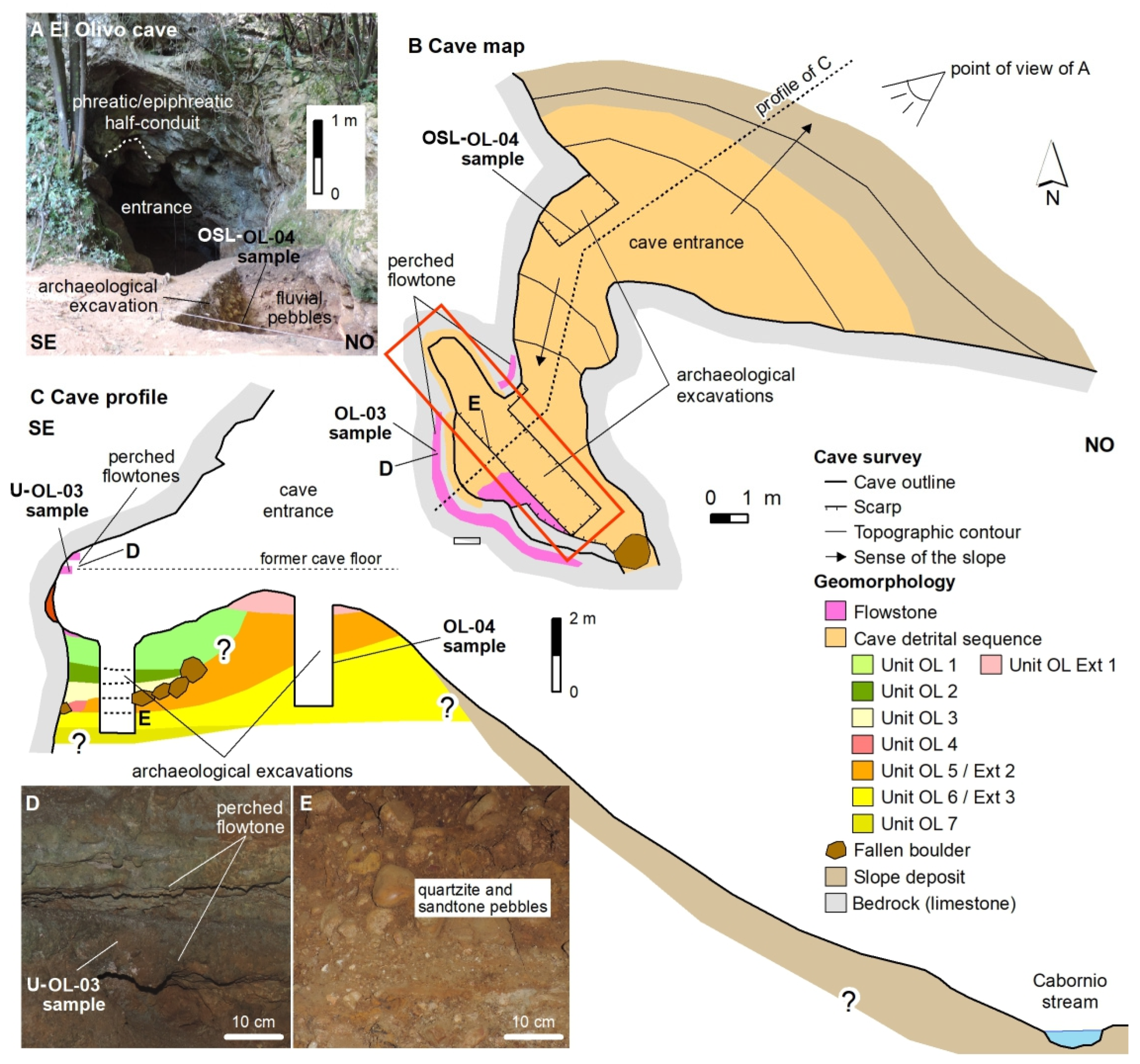
3. Geomorphology
4. Geoarchaeology
4.1. The Sequence
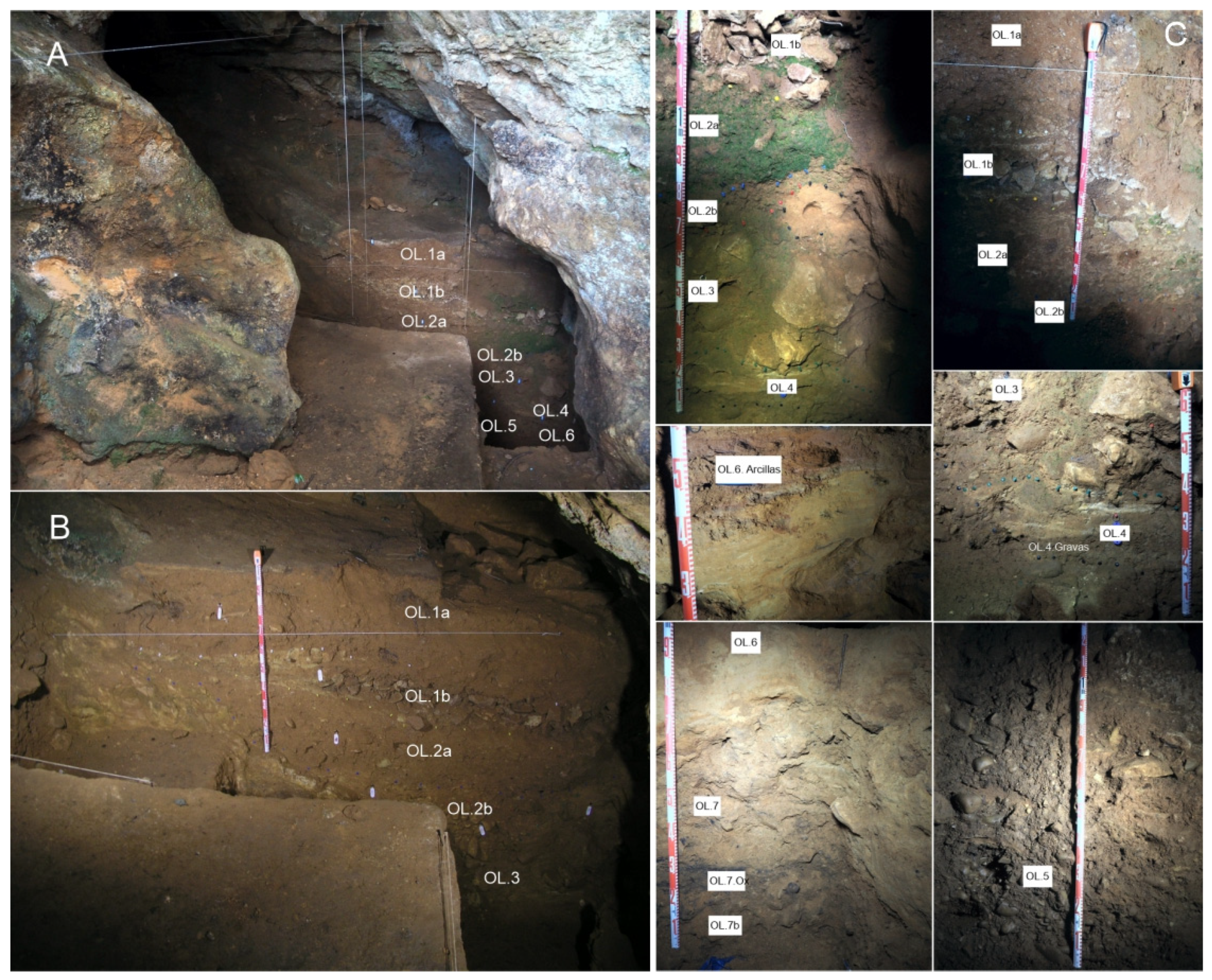
4.1.1. Lithostratigraphy
4.1.2. Archaeology
4.2. Sedimentological and Edaphological Analysis
4.2.1. Granulometry
- Group A encompasses sediments from the textural group of muddy sandy gravel (OL.5, OL.7a, OL.7b, OL.7 Ox, and OL.Exterior.2);
- Group B consists of sediments corresponding to the textural groups of gravelly muddy sand (OL.2a, OL.2b, and OL.4 gravas), slightly gravelly muddy sand (OL3, Ol.6 Arcillas, and OL.Arenas anteriores), muddy sand (OL.6, OL.Exterior 3 and OL.Arenas Exteriores), gravelly mud (OL.Exterior 1), and sandy mud.
- G-A Family: Includes the samples belonging to Group A in the triangular diagram of the total fraction (OL.5, OL.7a, OL.7b, OL.7 Ox, and OL.Exterior 2), which exhibit curves with an initial segment dominated by fine gravel and very coarse to fine sand, accounting for approximately 80 to 90% of the sediment. This is followed by a flatter segment containing very fine sands, silts, and clays, which comprise around 20% of the sediment (Figure 13). It corresponds to two types of deposits: on the one hand, clast-supported conglomerates with a limited matrix, indicating high-energy environments with subsequent settling of the finer particles that make up the matrix (OL.5 and OL.Exterior 2); and on the other hand, debris flow deposits with a minimal matrix that include both fluvial-derived and autochthonous clasts;
- G-B1 Family: It includes the samples OL.2a, OL.2b, OL.3, OL.4, and OL.4 gravas, which exhibit sigmoidal curves with three well-defined segments: an initial flat segment with varying presence of coarse and medium-grained sands, a steep middle segment with abundant fine sands and coarse silts, and a flat final segment with the remaining silts and clays (Figure 13). These curves indicate an essential population centered around fine sand and coarse silt, accompanied by silts, clays, and varying amounts of coarse sand and gravel. They indicate a typically fluvial environment with high to medium energy, characterized by freight transport through reptation, saltation, and suspension;
- G-B2 family: It includes samples OL.6, OL.Exterior 3, OL.Arenas Anteriores, and OL.Arenas Exteriores that exhibit curves with a strongly sigmoidal shape with three distinct sections. The first section is relatively flat and includes fine gravel and very coarse, coarse, and medium sands. The second section is steep and rapidly ascending, ranging from fine sands to coarse silts. The third section is again relatively flat and consists of the remaining silts and clays, extending to clays (Figure 13). These sections indicate the presence of a dominant population, the central one composed of fine sands and very coarse silts transported by saltation and suspension. These curves are typical of high-energy fluvial environments with a high sorting capacity;
- G-B3 family: It includes the samples OL.Exterior 1 and OL.6 Arcillas, which exhibit slightly sigmoidal curves. The first section is relatively flat and includes fine gravel and very coarse sand. The second section is steep and corresponds to an increase in the remaining sands until it reaches 50% of the sample. The final section, consisting of silt and clay (Figure 13), represents the remaining portion of the sample. This corresponds to fluvial sedimentation, where significant settling follows the initial bedload deposition.
4.2.2. Mineralogy
4.2.3. Calcium Carbonate, Organic Charcoal, and Organic Matter
4.2.4. Color and pH
5. Geochronology
6. Geoarchaeological and Geomorphological Interpretation
6.1. Geoarchaeological Interpretation
6.2. Paleogeographic Evolution
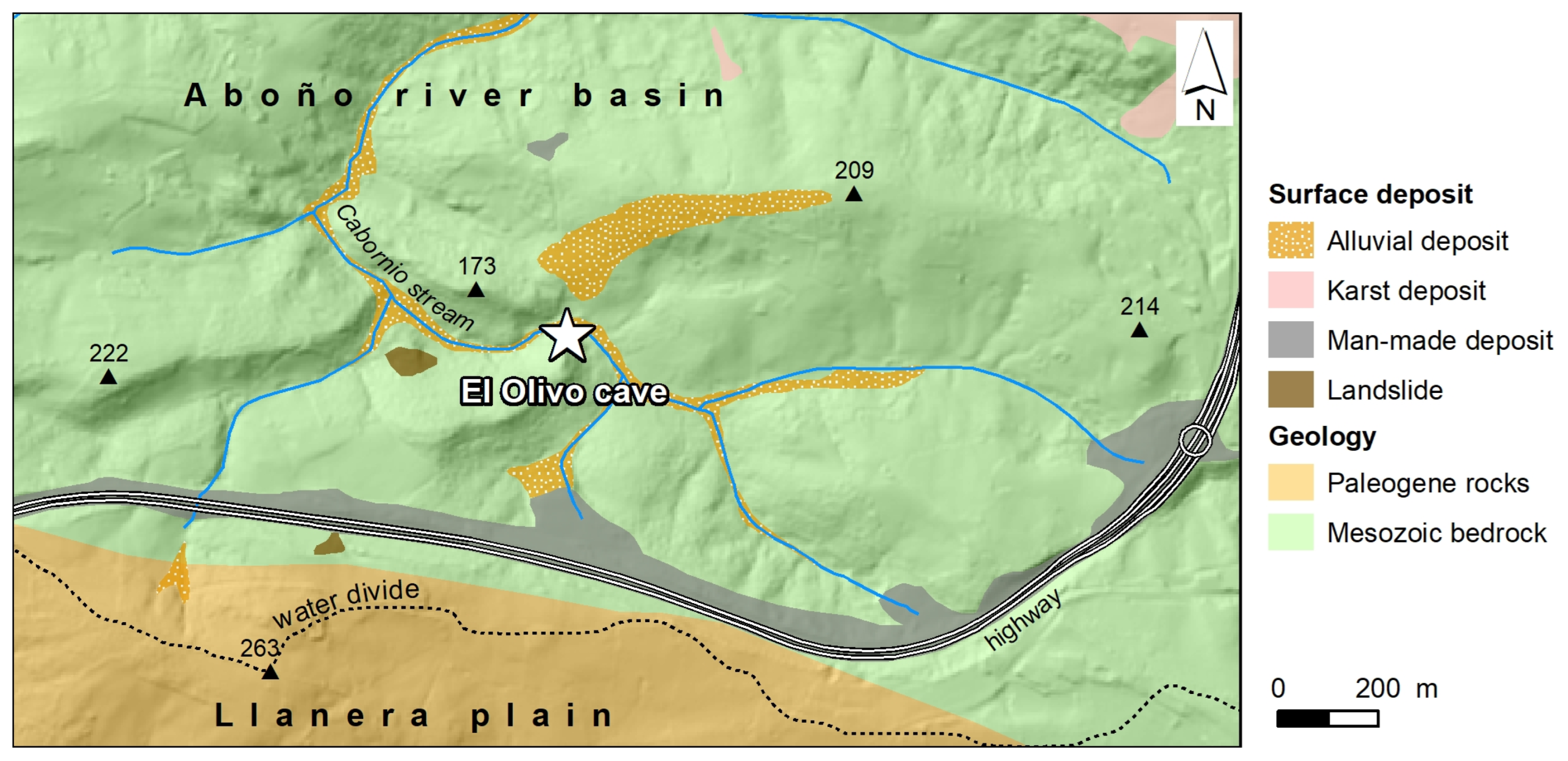
- The first phase began with the formation of El Olivo Cave within Cretaceous bedrock covered by Paleogene detrital rocks, which formed the Llanera plain (Figure 17A). The cave conduit originated when the water table was located 147 m above the present sea level. Therefore, Phase 1 took place a long time before the precipitation of the flowstone OL-03 at 189 ± 17 ka;
- Phase 2 comprised the entrenchment of the Aboño river network on the Llanera plain in the vicinity of El Olivo Cave (Figure 17B). The headwaters migrated southwards, eroding the Llanera plain. The fluvial incision also caused the lowering of the water table and the vadose development of the cave. Finally, the cave was partially filled by detrital sediments and flowstones precipitated at 189 ± 17 ka, coeval with the limit between OIS 7-6. These detrital and speleothem deposits remain perched on the cave walls. The cave infill would be related to the erosion of the Paleogene rocks (Figure 17B) and coincides with a sedimentary aggradation event in karst caves along the Cantabrian Region during OIS 7-6 [39,40,41];
- Fluvial incision, the drop of the water table, and the erosion of the Llanera plain continued during Phase 3 (Figure 17C). At the same time, the cave sedimentary infill was partially removed before or after the interception of the cave by the topographic surface. This led to the creation of the cave entrance, which allowed the potential entrance of fauna and humans, as shown by the probable presence of Neanderthal groups in the cave;
- Phase 4 corresponds to the deposition of sandstone, quartzite pebbles, and quartz sand transported by the Cabornio stream from Llanera plain to El Olivo Cave (Figure 17D). This implies the location of the Cabornio stream channel at the position of the cave. The alluvial deposition within the cave occurred around 24 ± 6 ka and would be related to alluvial fans developed under the dry and cold conditions of OIS-2;
- Fluvial incision continued during Phase 5 (Figure 17E), and humans frequented El Olivo Cave at the end of OIS-2, according to Álvarez-Alonso et al. (2018) [4]. Simultaneously, the stream flooded the cave, leading to sandy-loamy sediment with reworked archaeological remains during the OIS-2. Cabornio stream has descended 13 m from 24 ka to the present, representing an incision rate of 0.54 mm·a−1.
7. Conclusions
Supplementary Materials
Author Contributions
Funding
Data Availability Statement
Institutional Review Board Statement
Conflicts of Interest
References
- Álvarez-Alonso, D. El Paleolítico en la cuenca del río Aboño (Llanera). Excavaciones en los yacimientos de El Barandiallu y la cueva del Olivo. In Excavaciones Arqueológicas en Asturias 2007–2012; Consejería de Cultura, Principado de Asturias: Oviedo, Spain, 2013; Volume 7, pp. 57–68. [Google Scholar]
- Álvarez-Alonso, D. La cueva del Olivo (Llanera). Un nuevo yacimiento magdaleniense en el centro de Asturias. Nailos Estud. Interdiscip. Arqueol. 2014, 1, 181–192. Available online: https://nailos.org/index.php/nailos/article/view/62/69 (accessed on 23 July 2023).
- Álvarez-Alonso, D.; de Andrés Herrero, M.; Álvarez Fernández, E.; García-Ibaibarriaga, N.; Jordá Pardo, J.F.; Rojo, J. Los ’campamentos secundarios’ en el Magdaleniense cantábrico: Resultados preliminares de la excavación en la cueva del Olivo (Llanera, Asturias). In Cien Años de Arte Rupestre Paleolítico. Centenario del Descubrimiento de la Cueva de la Peña de Candamo (1914–2014); Corchón, M.S., Menéndez Fernández, M., Eds.; Acta salmanticensia; Estudios históricos y geográficos; Universidad de Slamanca: Salamanca, Spain, 2014; Volume 106, pp. 359–368. [Google Scholar]
- Álvarez-Alonso, D.; Álvarez- Fernández, E.; de Andrés Herrero, M.; Ballesteros, D.; Domínguez, M.; García-Ibaibarriaga, N.; Jordá-Pardo, J.F.; Yravedra, J. Excavaciones en el yacimiento paleolítico de la cueva del Olivo (Pruvia, Llanera): Campañas 2013–2016. In Excavaciones Arqueológicas en Asturias 2013–2016; Consejería de Cultura, Principado de Asturias: Oviedo, Spain, 2018; Volume 6, pp. 121–132. [Google Scholar]
- Álvarez-Alonso, D.; de Andrés Herrero, M.; Hevia Carrillo, A.; Mielgo Villalpando, C.; Yravedra, J. La cueva del Olivo (Pruvia, Llanera). Campaña de 2017. Excavaciones Arqueológicas en Asturias 2017–2020; Consejería de Cultura, Principado de Asturias: Oviedo, Spain, 2022; Volume 8, pp. 89–92. [Google Scholar]
- Álvarez-Alonso, D.; Rodríguez Asensio, J.A.; Jordá Pardo, J.F. Reflexiones en torno a la caracterización tecnotipológica del yacimiento de Bañugues (Asturias, España) en el marco del Paleolítico medio del norte de la Península Ibérica. Munibe 2014, 65, 5–24. Available online: https://www.aranzadi.eus/fileadmin/docs/Munibe/2014005024AA.pdf (accessed on 23 July 2023). [CrossRef]
- Álvarez-Alonso, D.; Jordá Pardo, J.F.; Carral, P.; Flor Blanco, G.; Flor, G.; Iriarte-Chiapusso, M.J.; Kehl, M.; Klasen, N.; Maestro, A.; Rodríguez Asensio, J.A.; et al. At the edge of the Cantabrian sea. New data on the Pleistocene and Holocene site of Bañugues (Gozón, Asturias, Spain): Palaeogeography, geoarchaeology and geochronology. Quat. Int. 2020, 566–567, 284–302. [Google Scholar] [CrossRef]
- Estrada García, R.; Jordá Pardo, J.F. Arqueología y gas natural: El Paleolítico medio de El Barandiallu (Villabona, Llanera, Asturias central). Península Ibérica. In XI Reunión Nacional de Cuaternario, Oviedo (Asturias), 2–3 y 4 de julio 2003; AEQUA and Universidad de Oviedo: Oviedo, Spain, 2003; pp. 253–260. [Google Scholar]
- Álvarez Alonso, D. Las cadenas operativas líticas de El Barandiallu (Asturias, norte de Iberia): Adaptación y variabilidad tecnológica en el contexto del Musteriense cantábrico. Munibe 2017, 68, 49–72. Available online: https://www.aranzadi.eus/fileadmin/docs/Munibe/maa.2017.68.11.pdf (accessed on 23 July 2023).
- Schiffer, M.B. Formation Processes of the Archaeological Record; University of New Mexico Press: Albuquerque, NM, USA, 1987. [Google Scholar]
- Wood, W.R.; Johnson, D.L. A survey of disturbance processes in archaeological site formation. In Advances in Archaeological Method and Theory, 1; Academic Press: New York, NY, USA, 1978; pp. 315–381. [Google Scholar]
- Merino-Tomé, O.; Suárez Rodríguez, A.; Alonso, J.; González Menéndez, L.; Heredia, N.; Marcos, A. Mapa Geológico Digital Continuo E. 1:50,000, Principado de Asturias (Zonas: 1100-1000-1600); Navas, J., Ed.; GEODE. Mapa Geológico Digital continuo de España; SIGECO-IGME: Madrid, Spain, 2013. [Google Scholar]
- Ballesteros, D.; Jiménez-Sánchez, M.; Giralt, S.; García-Sansegundo, J.; Meléndez-Asensio, M. A multi-method approach for speleogenetic research on alpine karst caves. Torca La Texa shaft, Picos de Europa (Spain). Geomorphology 2015, 247, 35–54. [Google Scholar] [CrossRef]
- Heeb, B. An all-in-one electronic cave surveying device. Cave Radio Electron. Group J. 2009, 72, 8–10. [Google Scholar]
- Fish, L. Computer Modelling of Cave Passages. Compass Tape 2001, 15, 19–24. [Google Scholar]
- Blott, S.J.; Pye, K. GRADISTAT: A grain size distribution and statistics package for the analysis of unconsolidated sediments. Earth Surf. Process. Landf. 2001, 26, 1237–1248. [Google Scholar] [CrossRef]
- Blott, S.J. GRADISTAT Version 8.0. In A Grain Size Distribution and Statistics Package for the Analysis of Unconsolidated Sediments by Sieving or Laser Granulomete; Kenneth Pye Associates Ltd., Crowthorne Enterprise Centre: Crowthorne, UK, 2010. [Google Scholar]
- Udden, J.A. Mechanical composition of clastic sediments. Bull. Geol. Soc. Am. 1914, 25, 655–744. [Google Scholar] [CrossRef]
- Wentworth, C.K. A scale of grade and class terms for clastic sediments. J. Geol. 1922, 30, 377–392. Available online: https://www.journals.uchicago.edu/doi/epdf/10.1086/622910 (accessed on 24 May 2023). [CrossRef]
- Chung, F.H. Quantitative interpretation of X-Ray diffraction patterns. III. Simultaneous determination of a set of reference intensities. J. Appl. Crystallogr. 1975, 8, 17–19. [Google Scholar] [CrossRef]
- Munsell, A.H. A Color Notation: An Illustrated System Defining All Colors and Their Relations by Measured Scales for Hue, Value and Chroma, 14th ed.; Munsell Color: Baltimore, MD, USA, 1981. [Google Scholar]
- Thomas, G.W. Soil pH and soil acidity. In Methods of Soil Analysis, Part 3—Chemical Methods; Soil Science Society of America: Madison, WI, USA, 1996; pp. 475–490. [Google Scholar]
- Bischoff, J.L.; Julià, R.; Mora, R. Uranium-series dating of the Mousterian occupation at at Abric Romaní, Spain. Nature 1988, 332, 68–70. [Google Scholar] [CrossRef]
- Talvitie, N.A. Electrodeposition of actinides for alpha spectrometric determination. Anal. Chem. 1972, 44, 280–283. [Google Scholar] [CrossRef]
- Hallstadius, L. A method for the electrodeposition of actinides. Nucl. Instrum. Methods Phys. Res. 1984, 223, 266–267. [Google Scholar] [CrossRef]
- Ivanovich, M.; Harmon, R.S. Uranium-Series Disequilibrium: Applications to Earth, Marine, and Environmental Sciences; Clarendon Press: Oxford, UK, 1992; 910p. [Google Scholar]
- Rosenbauer, R.J. UDATE1: A computer program for the calculation of Uranium- series isotopic ages. Comput. Geosci. 1991, 17, 45–75. [Google Scholar] [CrossRef]
- Murray, A.S.; Wintle, A.G. The single aliquot regenerative dose protocol: Potential for improvements in reliability. Radiat. Meas. 2003, 37, 377–381. [Google Scholar] [CrossRef]
- Murray, A.S.; Wintle, A.G. Luminescence dating of quartz using an improved single-aliquot regenerative-dose protocol. Radiat. Meas. 2000, 32, 57–73. [Google Scholar] [CrossRef]
- Galbraith, R.; Roberts, R.; Laslett, G.; Yoshida, H.; Olley, J. Optical dating of single and multiple grains of quartz from Jinmium Rock Shelter, Northern Australia: Part I. Experimental design and statistical models. Archaeometry 1999, 41, 339–364. [Google Scholar] [CrossRef]
- Brennan, B.J. Beta doses to spherical grains. Radiat. Meas. 2003, 37, 299–303. [Google Scholar] [CrossRef]
- Prescott, J.R.; Hutton, J.T. Cosmic ray contributions to dose rates for luminescence and ESR dating: Large depths and long term variations. Radiation Measurements 1994, 23, 497–500. [Google Scholar] [CrossRef]
- Guerin, G.; Mercier, N.; Adamiec, G. Dose-rate conversion factors: Update. Anc. TL 2011, 29, 5–8. Available online: http://ancienttl.org/ATL_29-1_2011/ATL_29-1_Guerin_p5-8.pdf (accessed on 20 May 2023).
- Reimer, P.J.; Bard, E.; Bayliss, A.; Beck, C.W.; Blackwell, G.; Bronk Ramsey, C.; Buck, C.E.; Cheng, H.; Edwards, R.L.; Friedrich, M.; et al. INTCAL13 and Marine 13 radiocarbon age calibration curves 0–50,000 years cal BC. Radiocarbon 2013, 55, 1869–1887. [Google Scholar] [CrossRef]
- Reimer, P.J.; Austin, W.E.N.; Bard, E.; Bayliss, A.; Blackwell, P.G.; Bronk Ramsey, C.; Butzin, M.; Cheng, H.; Edwards, R.L.; Friedrich, M.; et al. The IntCal20 Northern Hemisphere Radiocarbon Age Calibration Curve (0–55 cal k BP). Radiocarbon 2020, 62, 725–757. [Google Scholar] [CrossRef]
- Silva, P.G. Métodos de datación en el Cuaternario: La Cartografía del Cuaternario en España y la controversia del concepto “Datación Absoluta”. Cuatern. Geomorfol. 2022, 36, 9–18. [Google Scholar]
- Jordá Pardo, J.F.; Carral González, P. Estudio litoestratigráfico, sedimentológico y edafológico del registro del Pleistoceno superior de la cueva de Coímbre (zona B) (Asturias, España). In La cueva de Coímbre (Peñamellera Alta, Asturias); Fundación Masaveu: Oviedo, Spain, 2017; pp. 170–185. [Google Scholar]
- Hill, P.; Forti, P. Cave Minerals of the World, 2nd ed.; National Speleological Society: Huntsville, AL, USA, 1997. [Google Scholar]
- Arriolabengoa, M.; Intxaurbe, I.; Medina Alcaide, M.A.; Rivero, O.; Rios Garaizar, J.; Líbano, I.; Bilbao, P.; Aranburu, A.; Cheng, H.; Edwards, R.L.; et al. From Cave Geomorphology to Palaeolithic Human Behaviour: Speleogenesis, Palaeoenvironmental Changes and Archaeological Insight in the Atxurra—Armiña Cave (Northern Iberian Peninsula). J. Quat. Sci. 2020, 35, 841–853. [Google Scholar] [CrossRef]
- Flor, G.; Peón, A. Rasas y superficies de erosión continental en el relieve alpídico del noroeste peninsular y los depósitos terciarios. In Geomorfología do NW da Península Ibérica; Araújo, M.A., Gomes, A., Eds.; Faculdade de Letras da Universidade do Porto: Porto, Portugal, 2004; pp. 13–31. [Google Scholar]
- Ballesteros, D.; Giralt, S.; García-Sansegundo, J.; Jiménez-Sánchez, M. Quaternary Regional Evolution Based on Karst Cave Geomorphology in Picos de Europa (Atlantic Margin of the Iberian Peninsula). Geomorphology 2019, 336, 133–151. [Google Scholar] [CrossRef]
- Álvarez-Lao, D.J.; García, N. Chronological Distribution of Pleistocene Cold-Adapted Large Mammal Faunas in the Iberian Peninsula. Quat. Int. 2010, 212, 120–128. [Google Scholar] [CrossRef]
- Pinto-Llona, A.C.; Clark, G.; Karkanas, P.; Blackwell, B.; Skinner, A.R.; Andrews, P.; Reed, K.; Miller, A.; Macías-Rosado, R.; Vakiparta, J. The Sopeña Rockshelter, a New Site in Asturias (Spain) Bearing Evidence on the Middle and Early Upper Palaeolithic in Northern Iberia. Munibe Antropol.-Arkeol. 2012, 63, 45–79. Available online: https://www.aranzadi.eus/fileadmin/docs/Munibe/2012045079AA.pdf (accessed on 21 May 2023).
- Álvarez-Lao, D.J.; Ruiz-Zapata, M.B.; Gil-García, M.J.; Ballesteros, D.; Jiménez-Sánchez, M. Palaeoenvironmental Research at Rexidora Cave: New Evidence of Cold and Dry Conditions in NW Iberia during MIS 3. Quat. Int. 2015, 379, 35–46. [Google Scholar] [CrossRef]


| El Olivo Cave. U/Th date | |||||||||
| Unit | Sample | Lab code | 238U | 232Th | 234U/238U | 230Th/232Th | 230Th/234U | Date | |
| (ppm) | (ppm) | ||||||||
| Flowstone | U-OL-3 | 917 | 0.46 | 0.58 | 1.05 ± 0.02 | 2128 ± 0.062 | 0.83 ± 0.03 | 188,927 + 18,323/−15,739 | |
| El Olivo Cave. OSL date | |||||||||
| Unit | Sample | beta dose | gamma dose | cósmic dose | equivalent dose | annual dose | Date | ||
| (Gy/ka) | (Gy/ka) | (Gy/ka) | (Gy/ka) | (Gy/ka) | (ka) | ||||
| OL.Exterior.3 | OSL-OL-4 | 0.66 ± 0.17 | 0.046 ± 0.12 | 0.13 ± 0.006 | 29.5 ± 3.5 | 1.25 ± 0.30 | 23.5 ± 6.2 | ||
| El Olivo Cave. Radiocarbon date | |||||||||
| Unit | Sample | Lab code | Radiocarbon date BP | 13C/12C | Calibrated age 2σ cal BP | ||||
| OL.2b | C14-OL-1 | Beta-375569 | 13,960 ± 40 | −21 | 17,060–16,830 | ||||
Disclaimer/Publisher’s Note: The statements, opinions and data contained in all publications are solely those of the individual author(s) and contributor(s) and not of MDPI and/or the editor(s). MDPI and/or the editor(s) disclaim responsibility for any injury to people or property resulting from any ideas, methods, instructions or products referred to in the content. |
© 2023 by the authors. Licensee MDPI, Basel, Switzerland. This article is an open access article distributed under the terms and conditions of the Creative Commons Attribution (CC BY) license (https://creativecommons.org/licenses/by/4.0/).
Share and Cite
Jordá Pardo, J.F.; Álvarez-Alonso, D.; de Andrés-Herrero, M.; Ballesteros, D.; Carral, P.; Hevia-Carrillo, A.; Sanjurjo, J.; Giralt, S.; Jiménez-Sánchez, M. Geomorphology, Geoarchaeology, and Geochronology of the Upper Pleistocene Archaeological Site of El Olivo Cave (Llanera, Asturias, Northern Spain). Geosciences 2023, 13, 301. https://doi.org/10.3390/geosciences13100301
Jordá Pardo JF, Álvarez-Alonso D, de Andrés-Herrero M, Ballesteros D, Carral P, Hevia-Carrillo A, Sanjurjo J, Giralt S, Jiménez-Sánchez M. Geomorphology, Geoarchaeology, and Geochronology of the Upper Pleistocene Archaeological Site of El Olivo Cave (Llanera, Asturias, Northern Spain). Geosciences. 2023; 13(10):301. https://doi.org/10.3390/geosciences13100301
Chicago/Turabian StyleJordá Pardo, Jesús F., David Álvarez-Alonso, María de Andrés-Herrero, Daniel Ballesteros, Pilar Carral, Aitor Hevia-Carrillo, Jorge Sanjurjo, Santiago Giralt, and Montserrat Jiménez-Sánchez. 2023. "Geomorphology, Geoarchaeology, and Geochronology of the Upper Pleistocene Archaeological Site of El Olivo Cave (Llanera, Asturias, Northern Spain)" Geosciences 13, no. 10: 301. https://doi.org/10.3390/geosciences13100301