
Seismic Performance Screening and Evaluation for Embankments on Liquefiable Foundation Soils

Abstract
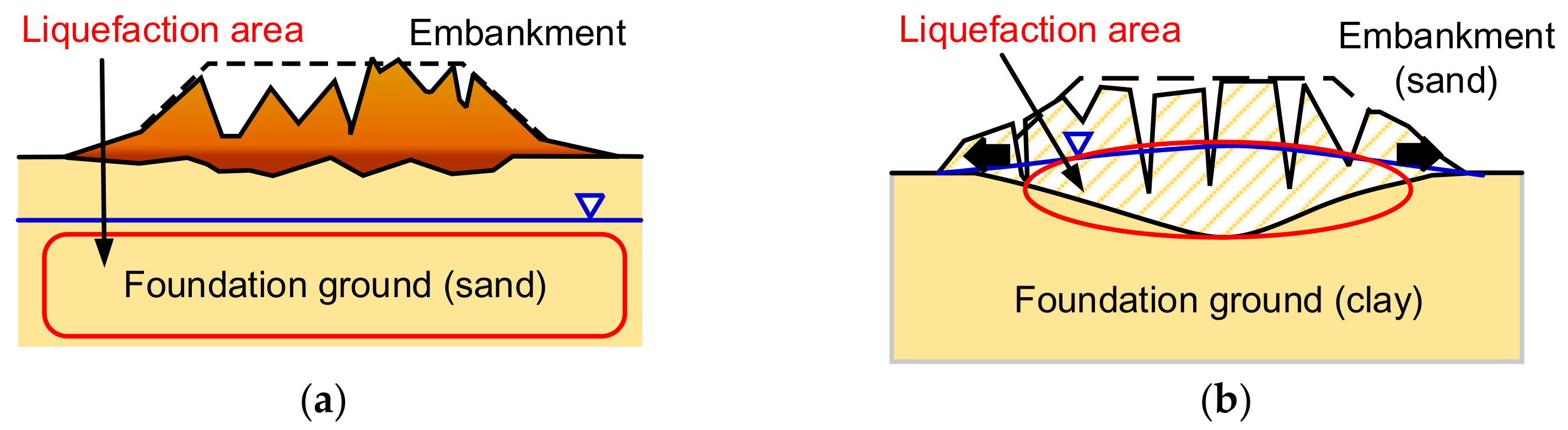
:1. Introduction
2. The Consideration for the Seismic Assessment
2.1. Seismic Performance
2.2. Seismic Safety Classification
2.3. Seismic Assessment Process for River Embankments
3. Seismic Evaluation of the Embankments
3.1. Preliminary Seismic Evaluation
3.2. Detailed Seismic Evaluation (Static Softening Method, SSM)
3.3. Detailed Seismic Evaluation (Dynamic Effective Stress Method, DESM)
4. Case Study
4.1. Basic Data of the Demonstration Site
4.2. Preliminary Seismic Evaluation
4.3. Detailed Seismic Evaluation (Static Softening Method, SSM)
4.4. Detailed Seismic Evaluation (Dynamic Effective Stress Method, DESM)
4.5. Discussion
5. Concluding Remarks
- Among the analyses, the preliminary evaluation is the simplest and conservative, so it is suitable for the preliminary screening of river embankments without safety concerns. The SSM can basically capture the deformation patterns of embankments located above liquefiable ground. However, the selection of parameters for the SSM has a great influence on the results. When a practical engineer conducts the SSM, the site characteristics of the analysis case should be carefully considered, and the appropriate empirical formula for the reduction of soil parameters can thus be selected. For an embankment of high importance, it is recommended to carry out DESM to reasonably estimate the settlement of the embankment subjected to the earthquake.
- In this evaluation process, the embankments with no safety concerns are initially screened out through simple screening criteria, so that the entirety of evaluation work can be more efficient. The proposed preliminary seismic evaluation only needs to use simple basic data; with the help of charts, tables and formulas, a relatively conservative earthquake resistance assessment of river embankments can be carried out. For the embankments with high safety concerns and high importance in the preliminary evaluation results, it is suggested that a detailed seismic evaluation be carried out; the SSM or DESM should be carried out using the FEM/FDM program to obtain a reasonable seismic response of the embankment.
- River embankments are important flood prevention facilities. It is necessary to start planning for seismic safety assessment and classification for the river embankments that are of high importance (metropolitan areas) and are located in the areas with severe liquefaction potential. For seismic capacity less than the requirements, it is recommended that the administration quickly improve its earthquake resistance and avoid the risk of secondary disasters caused by post-earthquake floods. For the embankments of major rivers, the administration should conduct a comprehensive preliminary seismic evaluation to identify the sections with damage potential after the shaking of the earthquake, and carry out detailed earthquake resistance evaluation work for the reference of subsequent earthquake resistance reinforcement operations.
- It is suggested that the preliminary screening work be carried out by competent personnel of the property management unit (such as the River Administration). The preliminary seismic evaluation in the earthquake resistance assessment process should be handled by professionals with a background in geotechnical engineering. For detailed seismic evaluation with high technical difficulty and the need to cooperate with numerical analysis, it is recommended to entrust a professional consulting company to handle it.
Author Contributions
Funding
Acknowledgments
Conflicts of Interest
References
- Public Construction Commission. Rapid Diagnosis and Reinforcement Strategy for Port and River Embankments after Earthquake; Report No. 106; Public Construction Commission: Taipei, Taiwan, 2000. (In Chinese) [Google Scholar]
- River Embankment Earthquake-Resistant Measures Emergency Review Committee. Report (Draft) on How to Proceed with Future Earthquake Resistance Measures for River Embankments Based on the Great East Japan Earthquake; River Embankment Earthquake-Resistant Measures Emergency Review Committee: Tokyo, Japan, 2011. (In Japanese) [Google Scholar]
- Sasaki, Y.; Towhata, I.; Miyamoto, K.; Shirato, M.; Narita, A.; Sasaki, T.; Sako, S. Reconnaissance report on damage in and around river levees caused by the 2011 off the Pacific coast of Tohoku earthquake. Soils Found. 2012, 52, 1016–1032. [Google Scholar] [CrossRef] [Green Version]
- Chiaradonna, A.; Tropeano, G.; d’Onofrio, A.; Silvestri, F. Interpreting the deformation phenomena of a levee damaged during the 2012 Emilia Earthquake. Soil Dyn. Earthq. Eng. 2019, 124, 389–398. [Google Scholar] [CrossRef]
- Tsai, C.C.; Hsu, S.Y.; Wang, K.L.; Yang, H.C.; Chang, W.K.; Chen, C.H.; Hwang, Y.W. Geotechnical reconnaissance of the 2016 ML6.6 Meinong Earthquake in Taiwan. J. Earth. Eng. 2017, 22, 1710–1736. [Google Scholar] [CrossRef]
- Kramer, S.L. Geotechnical Earthquake Engineering; Prentice Hall: Upper Saddle River, NJ, USA, 1996. [Google Scholar]
- Athanasopoulos-Zekkos, A.; Saadi, M. Ground motion selection for liquefaction evaluation analysis of earthen levees. Earth. Spectra 2012, 28, 1331–1351. [Google Scholar] [CrossRef]
- Perlea, V.; Chowdhury, K.; Perlea, M.; Hu, G. Selection of Most Appropriate Procedures for Seismic Evaluation of Levees Based on Case Histories. In Proceedings of the International Conference on Case Histories in Geotechnical Engineering, Chicago, IL, USA, 29 April–4 May 2013; Volume 79. [Google Scholar]
- Athanasopoulos-Zekkos, A.; Seed, R.B. Simplified methodology for consideration of 2D dynamic response of levees in liquefaction triggering evaluation. J. Geotech. Geoenviron. Eng. 2013, 139, 1911–1922. [Google Scholar] [CrossRef]
- Okamura, M.; Hayashi, S. Damage to River Levees by the 2011 Off the Pacific Coast Tohoku Earthquake and Prediction of Liquefaction in Levees; Geotechnics for Catastrophic Flooding Events, Taylor & Francis Group: London, UK, 2015; pp. 57–67. ISBN 978-1-138-02709-1. [Google Scholar]
- Athanasopoulos-Zekkos, A.; Pence, H.; Lobbestael, A. Ground motion selection for seismic slope displacement evaluation analysis of earthen levees. Earthq. Spectra 2016, 32, 217–237. [Google Scholar] [CrossRef]
- Gobbi, S.; Lopez-Caballero, F.; Forcellini, D. Numerical analysis of soil liquefaction induced failure of embankments. In Proceedings of the 6th International Conference on Computational Methods in Structural Dynamics and Earthquake Engineering Methods in Structural Dynamics and Earthquake Engineering, Rhodes Island, Greece, 15–17 June 2017. [Google Scholar] [CrossRef] [Green Version]
- Chiaradonna, A.; Flora, A.; d’Onofrio, A.; Bilotta, E. A pore water pressure model calibration based on in-situ test results. Soils Found. 2020, 60, 327–341. [Google Scholar] [CrossRef]
- Chiaradonna, A.; Ziotopoulou, K.; Carey, T.J.; DeJong, J.T.; Boulanger, R.W. Dynamic Behavior of Uniform Clean Sands: Evaluation of Constitutive Model Calibration Protocols in the Element- and the System-Level Scale. In Proceedings of the Geo-Congress 2022, Charlotte, NC, USA, 20–23 March 2022. [Google Scholar]
- Water and Disaster Management Bureau, Ministry of Land, Infrastructure, Transport and Tourism. Seismic Inspection Manual for River Embankments; Water and Disaster Management Bureau, Ministry of Land, Infrastructure, Transport and Tourism: Tokyo, Japan, 2016. (In Japanese) [Google Scholar]
- Ministry of Forests, Lands, and Natural Resource Operations–Flood Safety Section. Seismic Design Guidelines for Dikes, 1st ed.; Ministry of Forests, Lands, and Natural Resource Operations–Flood Safety Section: Victoria, British Columbia, Canada, 2011. [Google Scholar]
- Ministry of Forests, Lands, and Natural Resource Operations–Flood Safety Section. Seismic Design Guidelines for Dikes, 2nd ed.; Ministry of Forests, Lands, and Natural Resource Operations–Flood Safety Section: Victoria, British Columbia, Canada, 2014. [Google Scholar]
- Hwang, J.H.; Khoshnevisan, S.; Juang, C.H.; Lu, C.C. Soil liquefaction potential evaluation—An update of the HBF method focusing on research and practice in Taiwan. Eng. Geol. 2021, 280, 105926. [Google Scholar] [CrossRef]
- Youd, T.L.; Idriss, I.M.; Andrus, R.D.; Arango, I.; Castro, G.; Christian, J.T.; Dobry, R.; Liam, F.W.D.; Harder, L.F., Jr.; Hynes, M.E.; et al. Liquefaction resistance of soils: Summary report from the 1996 NCEER and 1998 NCEER/NSF workshops on evaluation of liquefaction resistance of soils. J. Geotech. Geoenviron. Eng. ASCE 2001, 127, 297–313. [Google Scholar] [CrossRef] [Green Version]
- Japan Road Association (JRA). Design Specifications for Highway Bridges, Part V Seismic Design; Japan Road Association (JRA): Tokyo, Japan, 1996. (In Japanese) [Google Scholar]
- Architectural Institute of Japan (AIJ). Recommendations for Design of Building Foundations; Architectural Institute of Japan (AIJ): Tokyo, Japan, 2001. (In Japanese) [Google Scholar]
- Stark, T.D.; Mesri, G. Undrained Shear Strength of Sands for Stability Analysis. J. Geotech. Eng. Div. ASCE 1992, 118, 1727–1747. [Google Scholar] [CrossRef]
- Idriss, I.M.; Boulanger, R.W. Soil Liquefaction during Earthquakes; EERI Monograph MNO-12; Earthquake Engineering Research Institute: Oakland, CA, USA, 2008. [Google Scholar]
- Itasca. FLAC: Fast Lagrangian Analysis of Continua; Itasca Consulting Group Inc.: Minneapolis, MN, USA, 2011. [Google Scholar]
- Boulanger, R.W.; Ziotopoulou, K. PM4Sand (Version 3.1): A Sand Plasticity Model for Earthquake Engineering Applications, Technical Report No. UCD/CGM-17/01; Center for Geotechnical Modeling, Department of Civil and Environmental Engineering, University of California: Davis, CA, USA, 2017. [Google Scholar]
- Kanyama, M.; Horii, K.; Kojima, K. Seismic Performance of Embankment Seismic Design; Railway Technical Research Institute: Tokyo, Japan, 1999; Volume 13. (In Japanese) [Google Scholar]
- Construction and Planning Agency, MOI. Seismic Design Specifications and Commentary of Buildings; Construction and Planning Agency, MOI: Taipei, Taiwan, 2011. (In Chinese) [Google Scholar]
- Kuhlemeyer, R.L.; Lysmer, J. Finite element method accuracy for wave propagation problem. J. Soil Mech. Found. Div. ASCE 1973, 99, 421–427. [Google Scholar] [CrossRef]
- Hwang, J.H.; Chang, C.T.; Chou, K.T.; Yu, M.S.; Jean, W.Y.; Yang, C.W.; Fang, J.S.; Tseng, L.S.; Wang, J.S.; Li, H.I. A Study on the Local Applicability of Liquefaction Assessment Methods Based on the Chi-Chi Earthquake Liquefaction Case; National Highway New Construction Bureau of Taiwan District, Ministry of Communications: Taipei, Taiwan, 2005. (In Chinese) [Google Scholar]


| Classification | Post-Seismic Settlement of Embankment Crest | |
|---|---|---|
| Damage Degree of the Embankment | Flood Overflow | |
| I | <25% of the embankment height | - |
| II | 25~50% of the embankment height | - |
| III | 50~75% of the embankment height | - |
| IV | >75% of the embankment height | >the allowable settlement |
| Horizontal Length in Front of the Embankment toe ℓ (m) | Correction Coefficient μ2 |
|---|---|
| ℓ ≤ 10 | 0.8 |
| 10 < ℓ ≤ 30 | 0.9 |
| 30 < ℓ | 1.0 |
| Factor of Safety against Soil Liquefaction (FL) a | Reduction Factor β | |
|---|---|---|
| Condition A b | Condition B c | |
| FL ≤ 1.0 | 0.25 | 0.4 |
| 1.0 < FL ≤ 1.1 | 0.45 | 0.6 |
| 1.1 < FL ≤ 1.25 | 0.7 | 0.85 |
| 1.25 < FL ≤ 1.5 | 0.9 | 0.95 |
| 1.5 < FL | 1.0 | 1.0 |
| Classification | Damage Degree of the Embankment | Dynamic Factor of Safety (FSd) | |
|---|---|---|---|
| Fsd(kh) | Fsd(∆u) | ||
| I | <25% of the embankment height | 1.0 < FSd | |
| II | 25%~50% of the embankment height | 0.8 < FSd ≤ 1.0 | |
| III | 50%~75% of the embankment height | FSd ≤ 0.8 | 0.6 < FSd ≤ 0.8 |
| IV | >75% of the embankment height | - | FSd ≤ 0.6 |
| Logging | USCS | Depth (m) | γt (kN/m3) | SPT-N | FC (%) | Soil Liquefaction Evaluation | ||
|---|---|---|---|---|---|---|---|---|
| CSR | CRR | FL | ||||||
 | ML | 0.8 | 18.25 | 2 | 56 | - | - | 3.00 |
| SM | 2.7 | 18.44 | 7 | 29 | 0.29 | 0.18 | 0.61 | |
| SM | 3.7 | 18.44 | 7 | 29 | 0.34 | 0.16 | 0.47 | |
| SM | 4.9 | 19.33 | 13 | 20 | 0.37 | 0.25 | 0.69 | |
| SM | 6.0 | 19.72 | 4 | 17 | 0.39 | 0.11 | 0.29 | |
| SM | 6.7 | 19.91 | 19 | 30 | 0.39 | 0.46 | 1.18 | |
| SM | 8.3 | 19.91 | 16 | 30 | 0.40 | 0.28 | 0.70 | |
| SM | 11.0 | 21.19 | 32 | 30 | - | - | 3.00 | |
| CL | 13.3 | 20.40 | 16 | 75 | - | - | 3.00 | |
| CL | 14.0 | 20.40 | 27 | 75 | - | - | 3.00 | |
| SM | 17.0 | 21.19 | 28 | 30 | 0.34 | 0.45 | 1.33 | |
| GM | 19.0 | 22.00 | 100 | - | - | - | 3.00 | |
| Soil Layers | USCS | N-Value | γt (kN/m3) | c′ (kPa) | ϕ′ (deg) | G (MPa) | K (MPa) | Liq? |
|---|---|---|---|---|---|---|---|---|
| Embankment | SM | 10 | 16.37 | 3.0 | 30.0 | 9.08 | 27.25 | No |
| Floodplain | SM | 10 | 19.35 | 1.0 | 29.1 | 9.08 | 27.25 | Yes |
| L1 | ML | 2 | 18.60 | 23.5 | 0.0 | 1.75 | 8.18 | No |
| L2 | SM | 7 | 18.81 | 0.0 | 26.8 | 6.36 | 19.08 | Yes |
| L3 | SM | 13 | 19.75 | 0.0 | 31.1 | 11.81 | 35.43 | Yes |
| L4 | SM | 4 | 20.10 | 0.0 | 23.9 | 3.63 | 10.90 | Yes |
| L5 | SM | 19 | 20.28 | 0.0 | 34.5 | 17.26 | 51.78 | No |
| L6 | SM | 16 | 20.28 | 0.0 | 32.9 | 14.53 | 43.60 | Yes |
| L7 | SM | 32 | 21.56 | 0.0 | 40.3 | 29.07 | 87.20 | No |
| L8 | CL | 16 | 20.80 | 94.2 | 0.0 | 13.17 | 654.00 | No |
| L9 | CL | 27 | 20.80 | 158.9 | 0.0 | 22.22 | 1103.63 | No |
| L10 | SM | 28 | 21.58 | 0.0 | 38.7 | 25.43 | 76.30 | No |
| PM4Sand Model | |||||||
|---|---|---|---|---|---|---|---|
| Soil Layers | USCS | γt (kN/m3) | Dr | ν | Go | hpo | Hydraulic Conductivity, k (cm/s) |
| Floodplain | SM | 19.35 | 0.69 | 0.35 | 738 | 0.2 | 1.96 × 10⁻³ |
| L1 | ML | 18.60 | 0.33 | 0.40 | 447 | 0.2 | 9.80 × 10⁻⁵ |
| L2 | SM | 18.81 | 0.55 | 0.35 | 614 | 0.2 | 3.92 × 10⁻³ |
| L3 | SM | 19.75 | 0.67 | 0.35 | 770 | 0.2 | 1.96 × 10⁻³ |
| L4 | SM | 20.10 | 0.35 | 0.35 | 473 | 0.2 | 9.80 × 10⁻³ |
| L5 | SM | 20.28 | 0.78 | 0.35 | 917 | 0.2 | 1.96 × 10⁻³ |
| L6 | SM | 20.28 | 0.69 | 0.35 | 825 | 0.2 | 1.96 × 10⁻³ |
| L7 | SM | 21.56 | 0.92 | 0.35 | 1154 | 0.2 | 9.80 × 10⁻⁴ |
| L10 | SM | 21.58 | 0.77 | 0.35 | 984 | 0.4 | 1.96 × 10⁻³ |
| Mohr–Coulomb + hysteretic damping | |||||||
| Soil layers | USCS | γt (kN/m3) | c′ (kPa) | ϕ′ (deg) | G (MPa) | K (MPa) | Hydraulic conductivity, k (cm/s) |
| Embankment | SM | 16.37 | 3.0 | 30.0 | 53.7 | 161.2 | 9.80 × 10⁻⁴ |
| L8 | CL | 20.80 | 94.2 | 0.0 | 95.4 | 4739.3 | 9.80 × 10⁻⁶ |
| L9 | CL | 20.80 | 158.9 | 0.0 | 135.3 | 6717.5 | 9.80 × 10⁻⁶ |
| Item | Preliminary Seismic Evaluation | Detailed Seismic Evaluation | ||||
|---|---|---|---|---|---|---|
| SSM | DESM | |||||
| Stark & Mesri [22] | Idriss & Boulanger [23] | |||||
| Upper Relation. | Lower Relation. | Upper Relation. | Lower Relation. | |||
| Settlement (m) | 3.29 | 0.79 | 1.48 | 0.30 | 1.00 | 0.36 |
| Settlement ratio a (%) | >75.0 | 18.0 | 33.7 | 6.9 | 22.8 | 8.0 |
| Seismic safety classification | IV | I | II | I | I | I |
Publisher’s Note: MDPI stays neutral with regard to jurisdictional claims in published maps and institutional affiliations. |
© 2022 by the authors. Licensee MDPI, Basel, Switzerland. This article is an open access article distributed under the terms and conditions of the Creative Commons Attribution (CC BY) license (https://creativecommons.org/licenses/by/4.0/).
Share and Cite
Lu, C.-C.; Chen, K.-Y.; Cheng, Y.-T.; Han, Y.-H. Seismic Performance Screening and Evaluation for Embankments on Liquefiable Foundation Soils. Geosciences 2022, 12, 221. https://doi.org/10.3390/geosciences12060221
Lu C-C, Chen K-Y, Cheng Y-T, Han Y-H. Seismic Performance Screening and Evaluation for Embankments on Liquefiable Foundation Soils. Geosciences. 2022; 12(6):221. https://doi.org/10.3390/geosciences12060221
Chicago/Turabian StyleLu, Chih-Chieh, Kuan-Yu Chen, Yun-Ta Cheng, and Yu-Hung Han. 2022. "Seismic Performance Screening and Evaluation for Embankments on Liquefiable Foundation Soils" Geosciences 12, no. 6: 221. https://doi.org/10.3390/geosciences12060221