

Near-Surface Geophysical Characterization of Lithologies in Corfu and Lefkada Towns (Ionian Islands, Greece)
 , ,
, ,  , and
, and
Abstract
:1. Introduction
2. Geological Setting
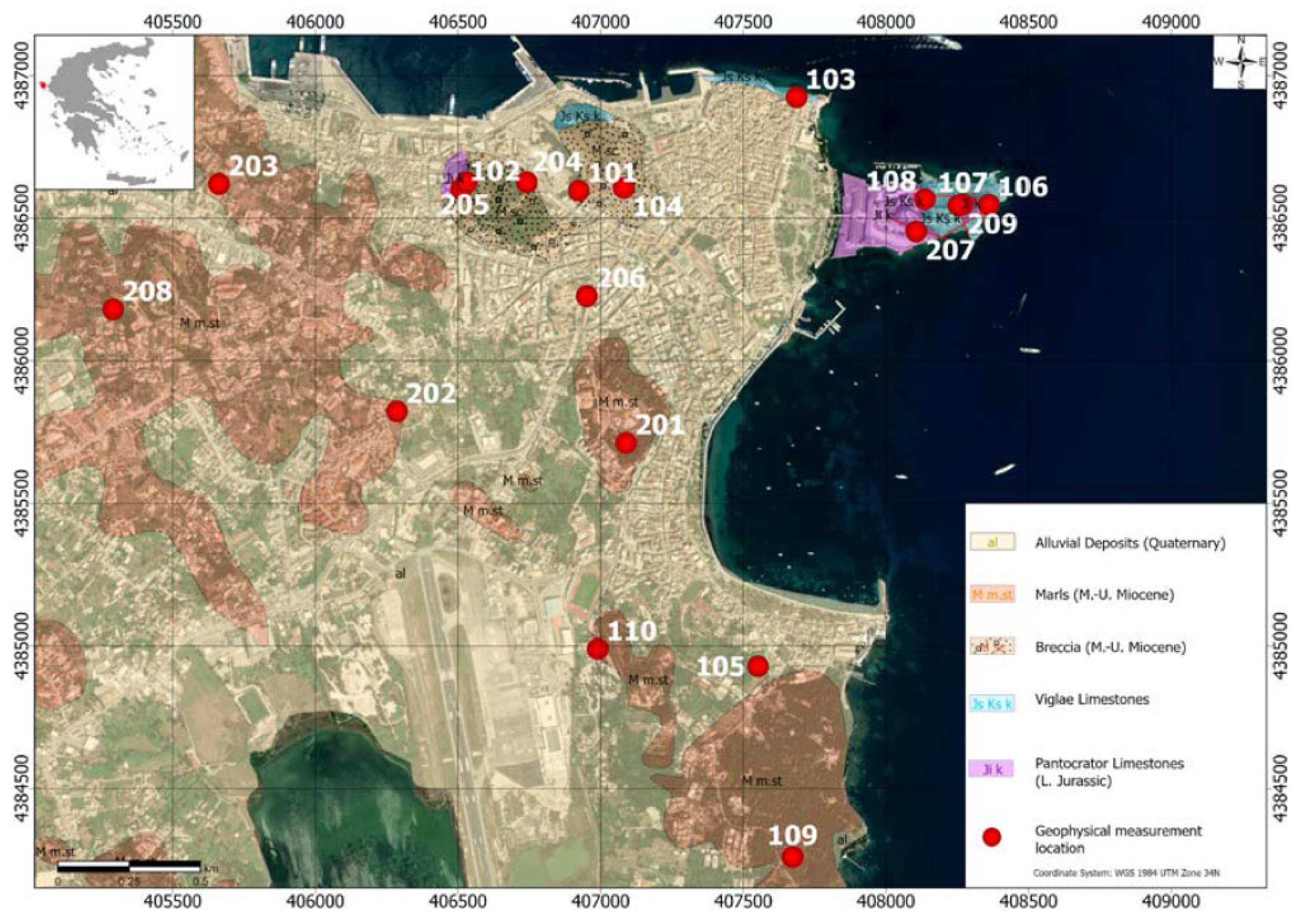
2.1. Corfu Town
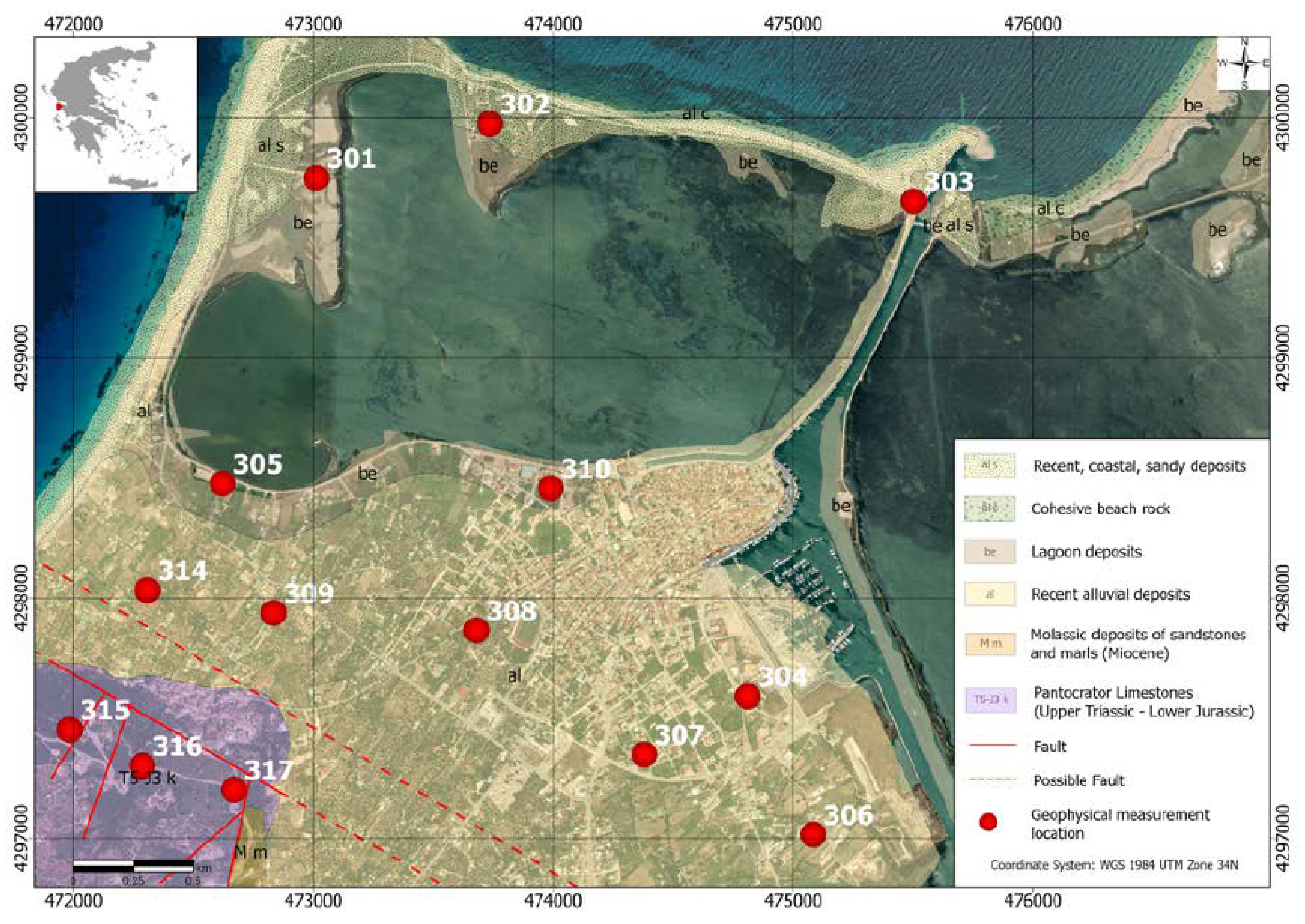
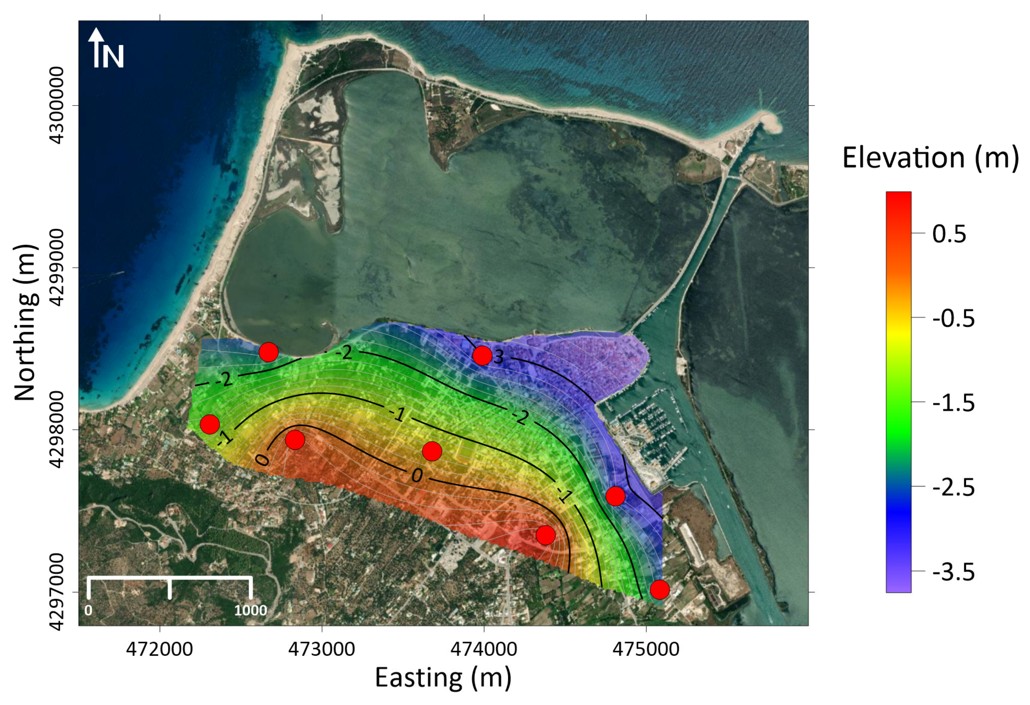
2.2. Lefkada Town

3. Methodology
3.1. Seismic Method
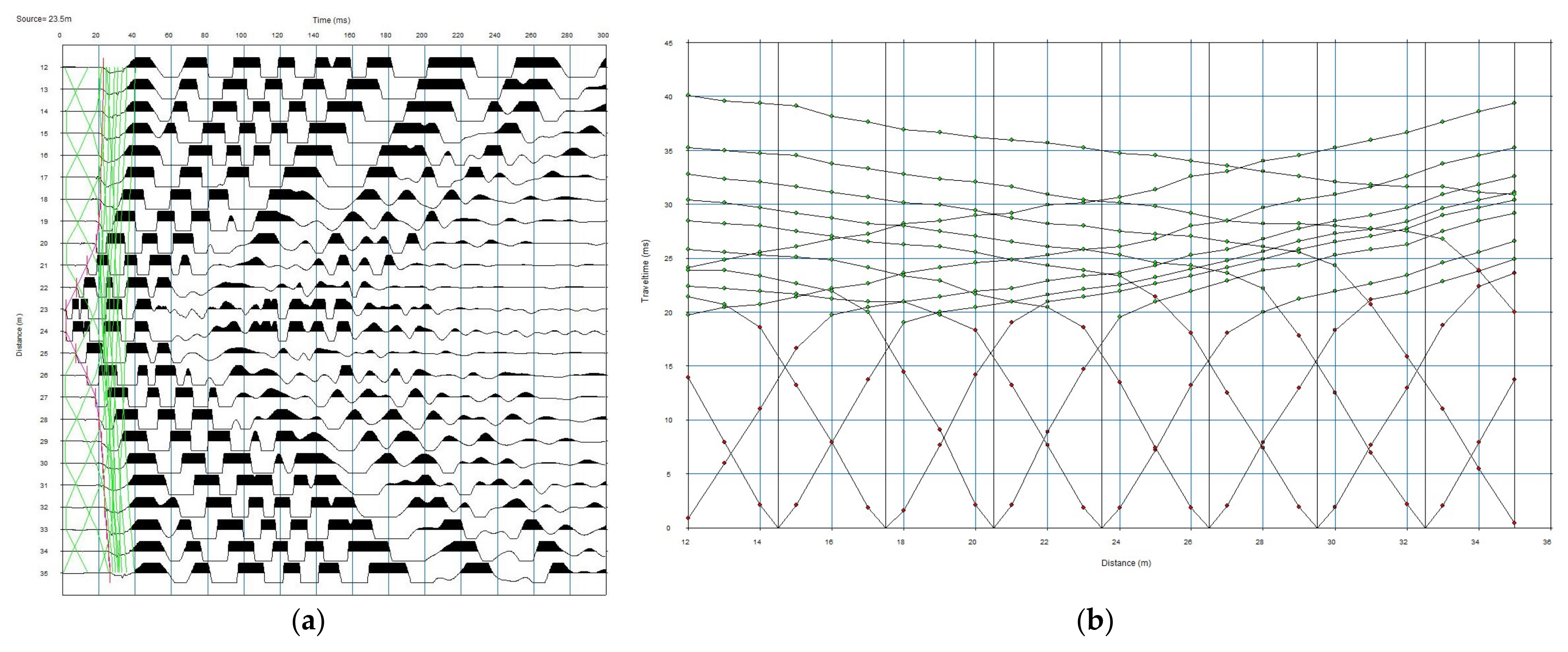
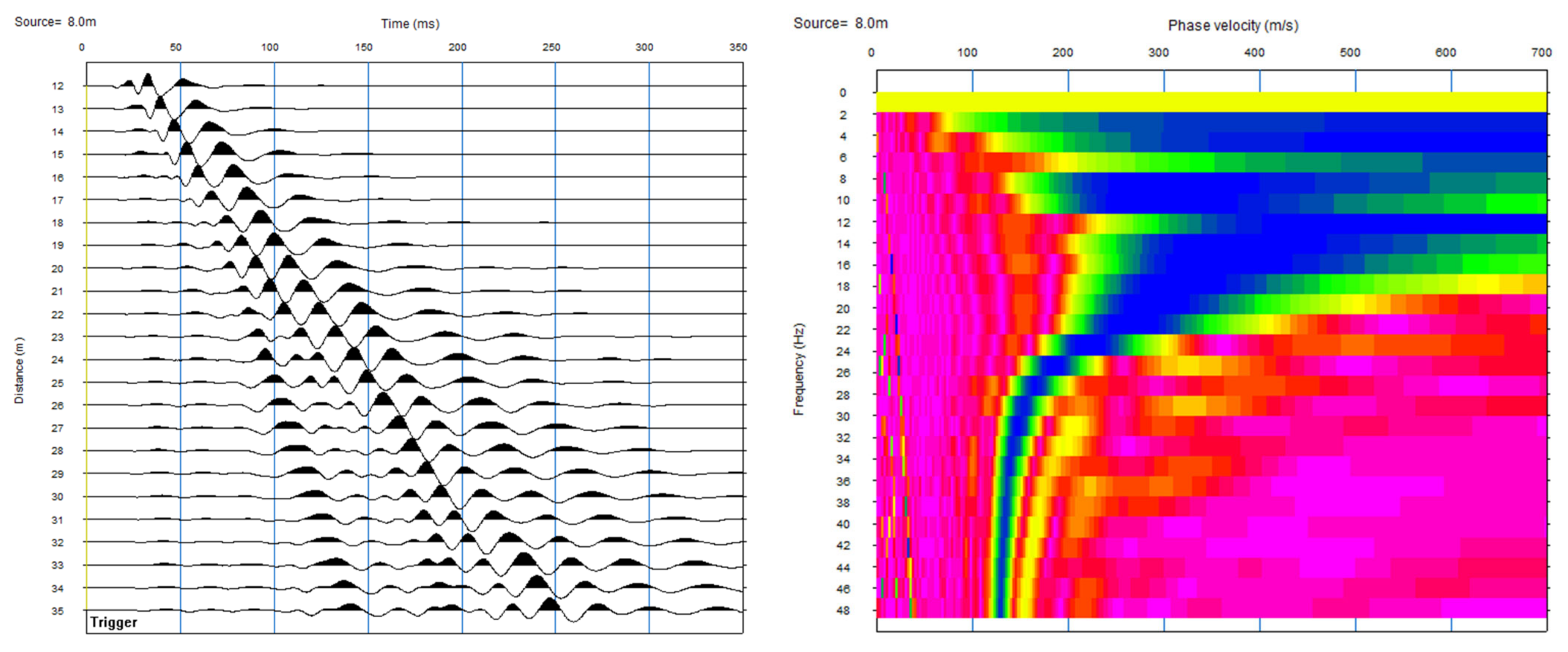
3.1.1. Data Acquisition
3.1.2. Processing
3.2. Electrical Resistivity Tomography
3.3. Density Determination
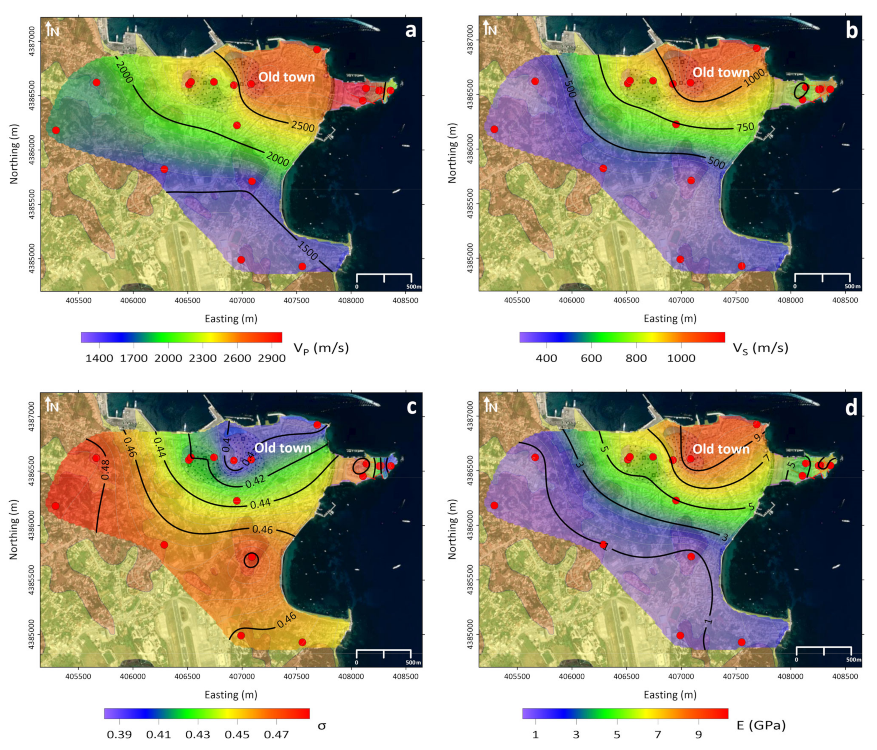
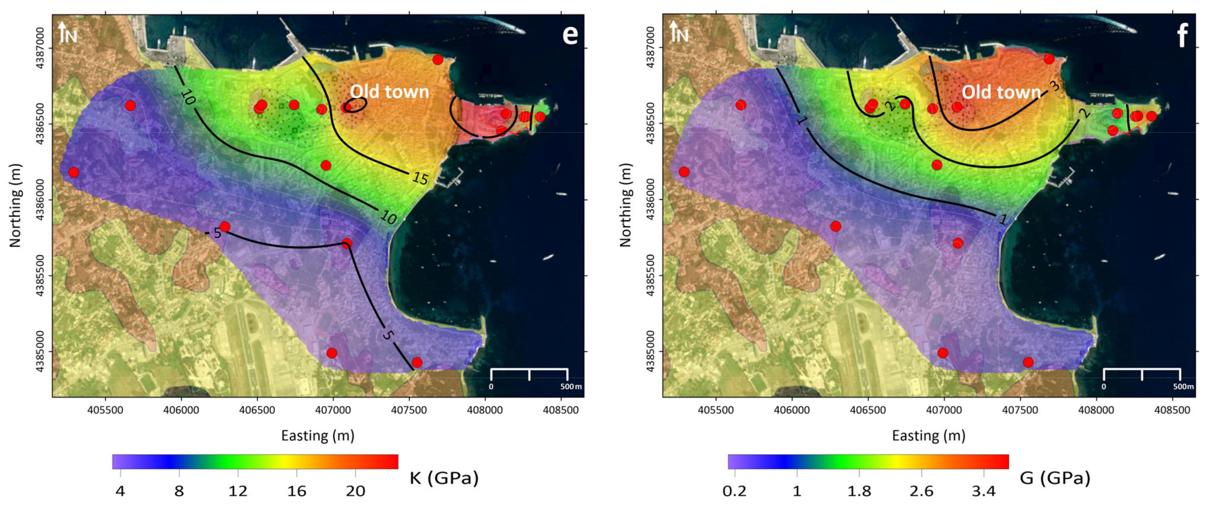
4. Interpretation
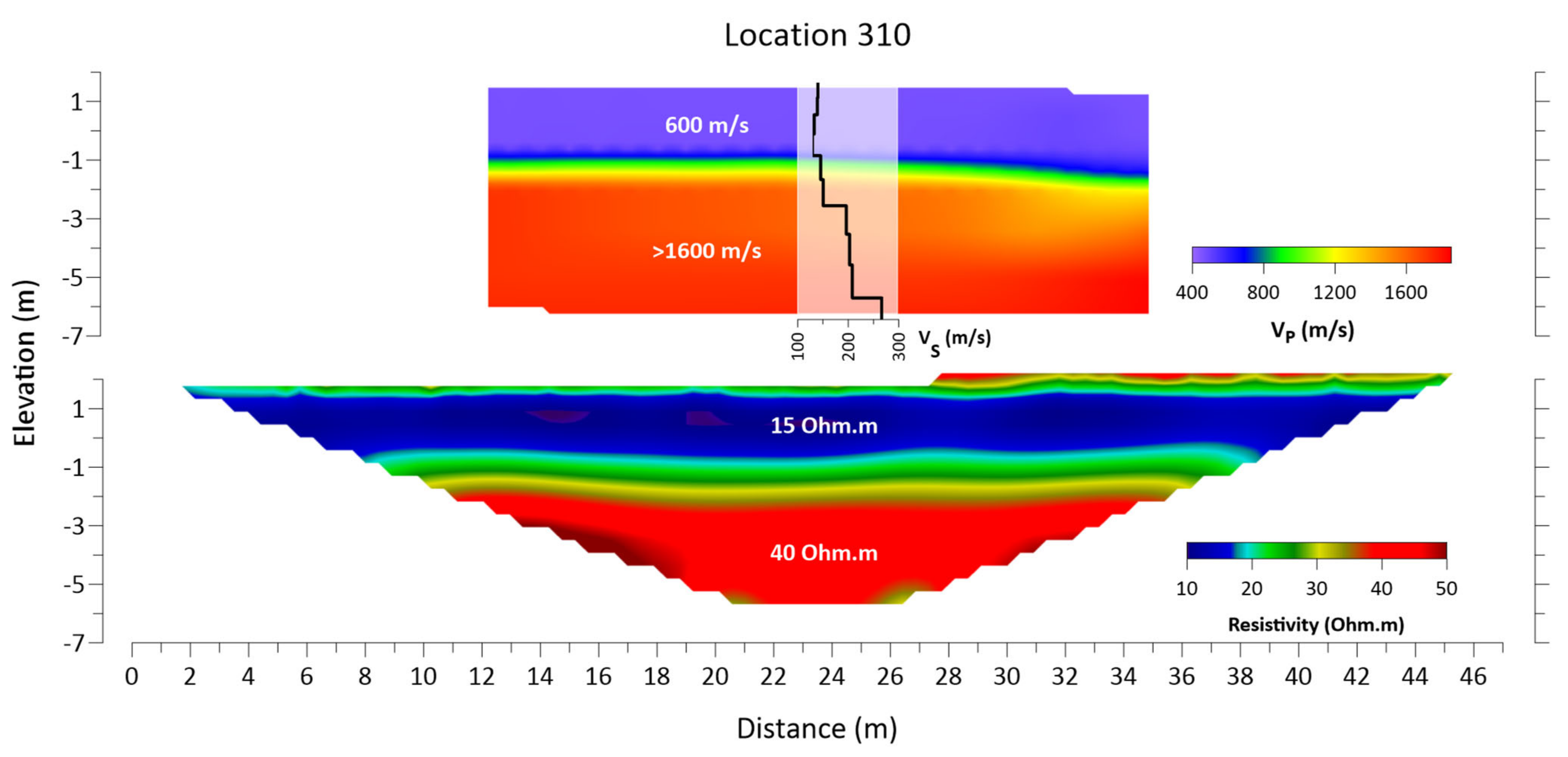
4.1. Marl (M m.st/M m)
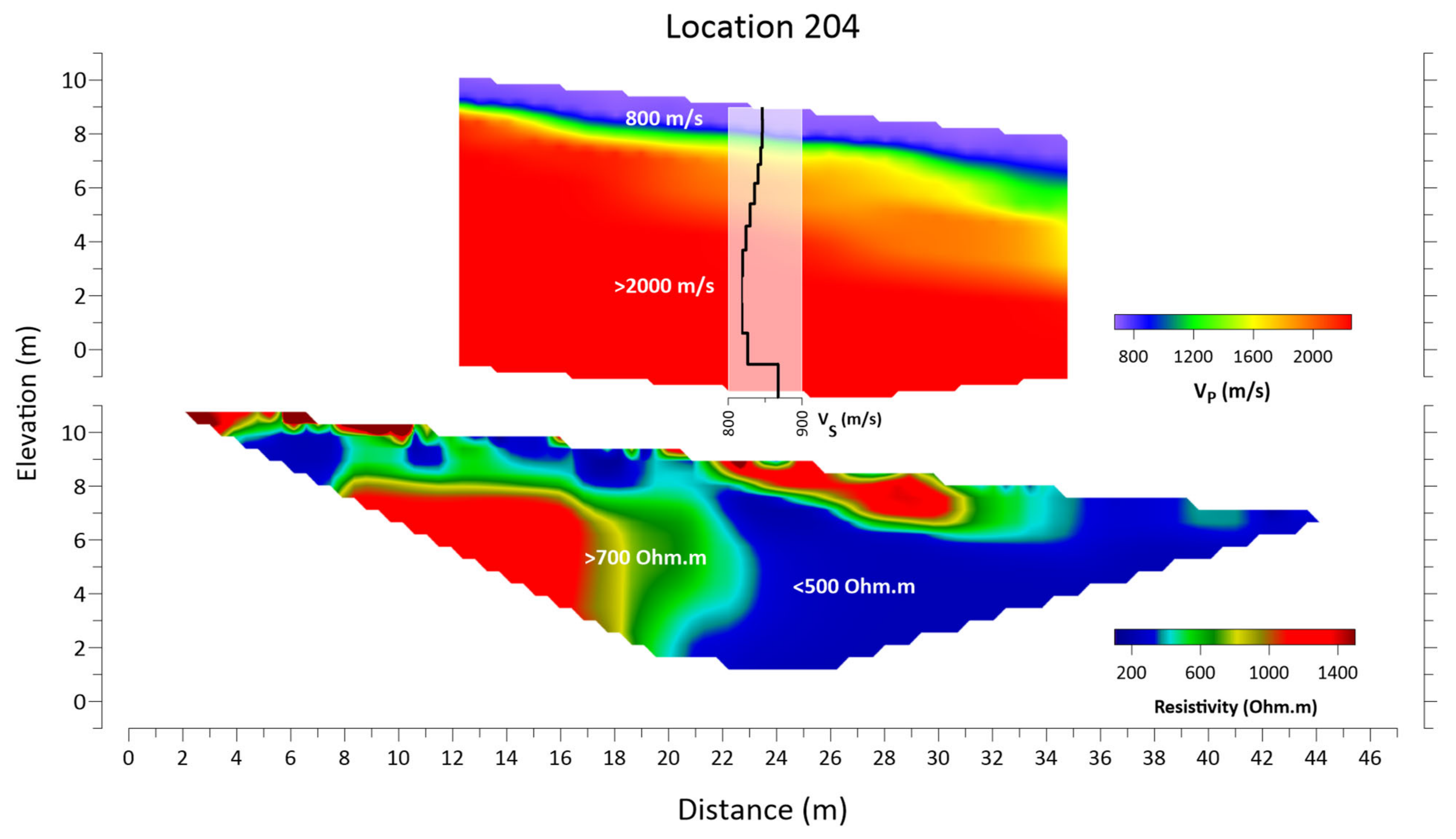
4.2. Breccia (M sc)
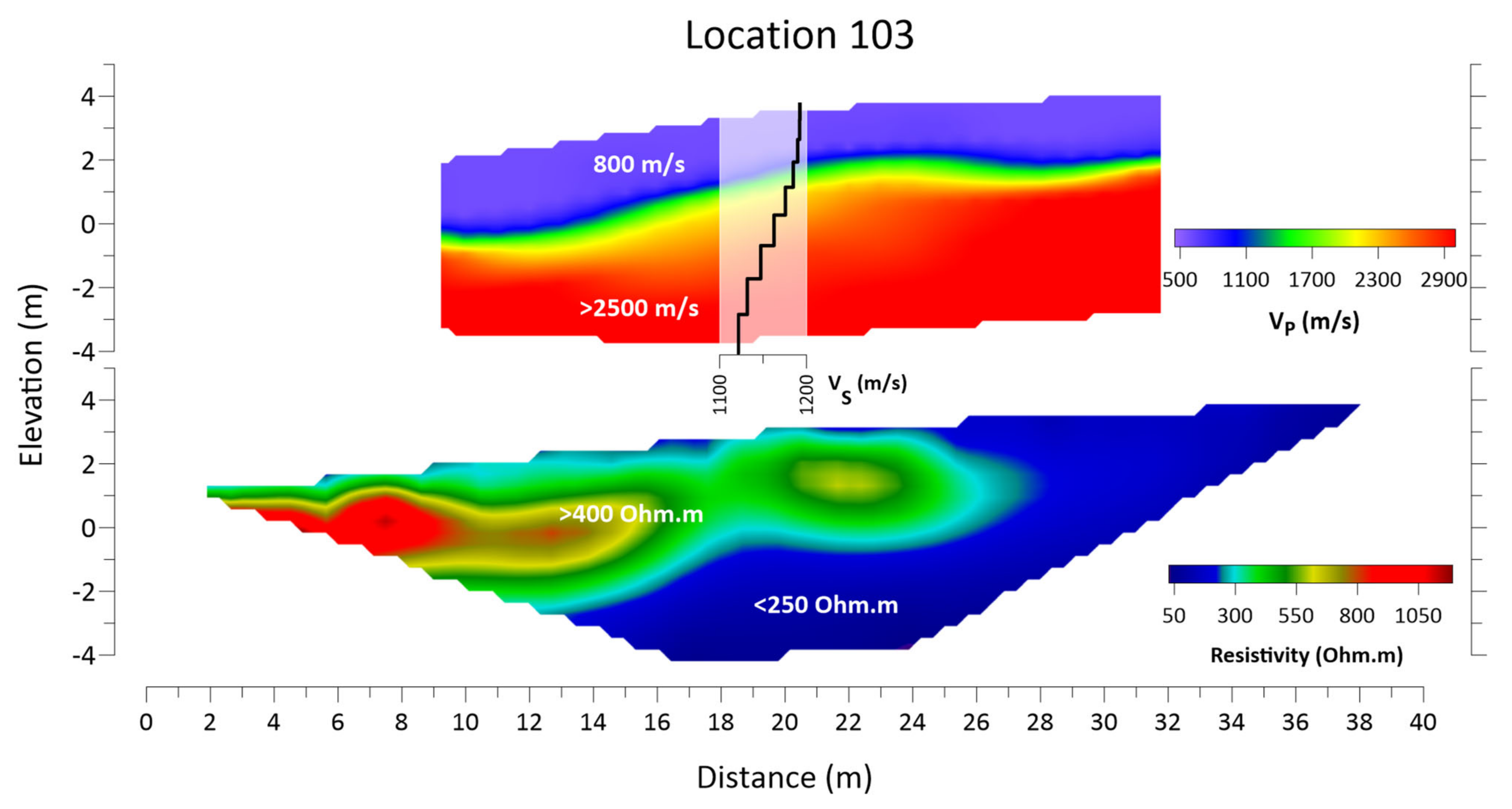
4.3. Viglae Limestone (Js Ks k)
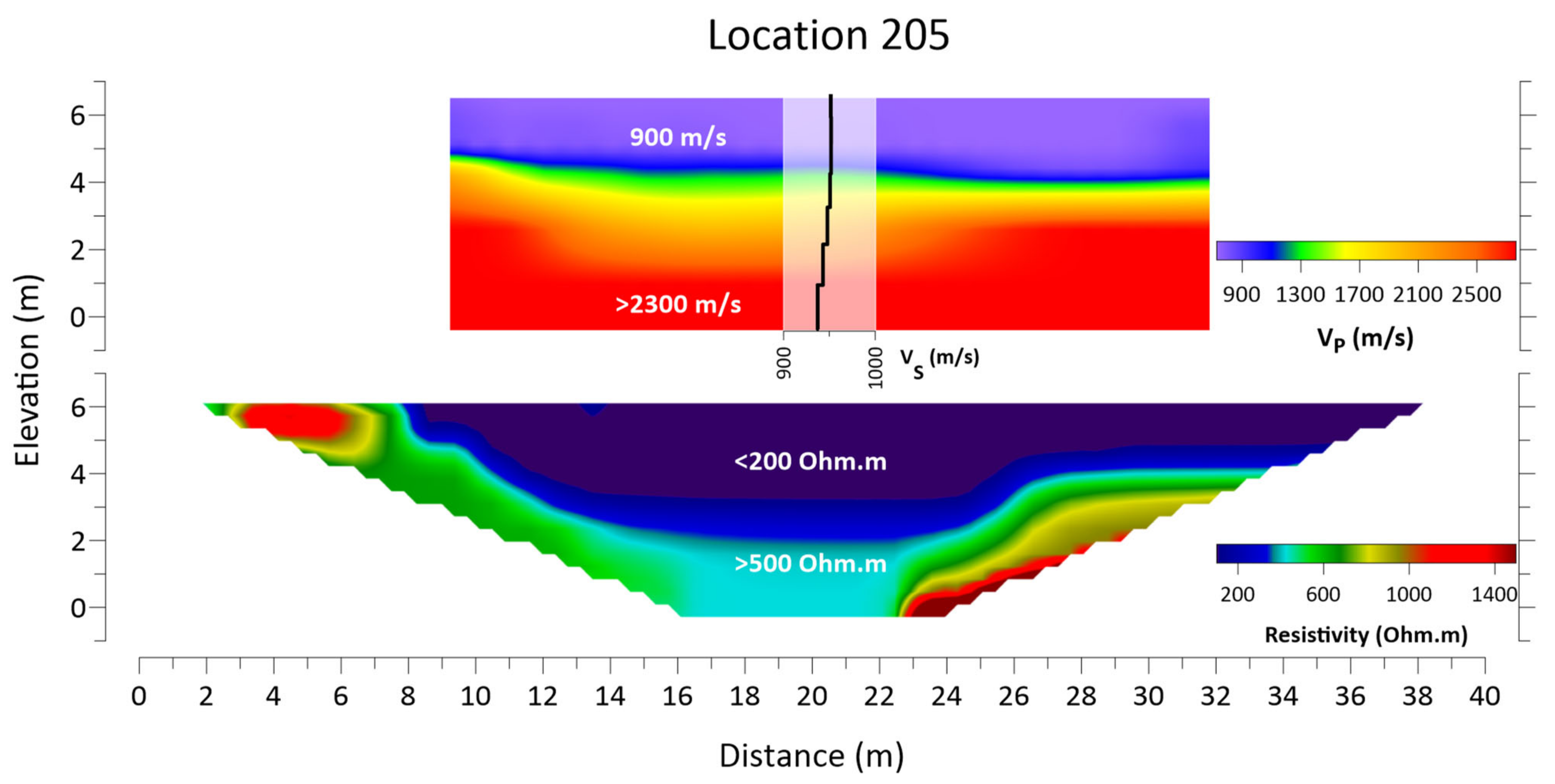
4.4. Pantocrator Limestone (Ji k)
5. Discussion and Elastic Moduli
6. Conclusions
Author Contributions
Funding
Data Availability Statement
Acknowledgments
Conflicts of Interest
References
- Ganas, A.; Elias, P.; Bozionelos, G.; Papathanassiou, G.; Avallone, A.; Papastergios, A.; Valkaniotis, S.; Parcharidis, I.; Briole, P. Coseismic deformation, field observations and seismic fault of the 17 November 2015 M = 6.5, Lefkada Island, Greece earthquake. Tectonophysics 2016, 687, 210–222. [Google Scholar] [CrossRef]
- Karakostas, V.G.; Papadimitriou, E.E.; Papazachos, C.B. Properties of the 2003 Lefkada, Ionian Islands, Greece, earthquake seismic sequence and seismicity triggering. Bull. Seismol. Soc. Am. 2004, 94, 1976–1981. [Google Scholar] [CrossRef] [Green Version]
- Lekkas, E.; Mavroulis, S.; Carydis, P.; Alexoudi, V. The 17 November 2015 Mw 6.4 Lefkada (Ionian Sea, Western Greece) Earthquake: Impact on Environment and Buildings. Geotech. Geol. Eng. 2018, 36, 2109–2142. [Google Scholar] [CrossRef]
- Papadimitriou, E.; Karakostas, V.; Mesimeri, M.; Chouliaras, G.; Kourouklas, C. The Mw6.5 17 November 2015 Lefkada (Greece) earthquake: Structural interpretation by means of the aftershock analysis. Pure Appl. Geophys. 2017, 174, 3869–3888. [Google Scholar] [CrossRef]
- Papathanassiou, G.; Pavlides, S.; Ganas, A. The 2003 Lefkada earthquake: Field observations and preliminary microzonation map based on liquefaction potential index for the town of Lefkada. Eng. Geol. 2005, 82, 12–31. [Google Scholar] [CrossRef]
- Sakkas, V.; Kapetanidis, V.; Kaviris, G.; Spingos, I.; Mavroulis, S.; Diakakis, M.; Alexopoulos, J.D.; Kazantzidou-Firtinidou, D.; Kassaras, I.; Dilalos, S.; et al. Seismological and Ground Deformation Study of the Ionian Islands (W. Greece) during 2014–2018, a Period of Intense Seismic Activity. Appl. Sci. 2022, 12, 2331. [Google Scholar] [CrossRef]
- Makropoulos, K.; Kaviri, G.; Kouskouna, V. An updated and extended earthquake catalogue for Greece and adjacent areas since 1900. Nat. Hazards Earth Syst. Sci. 2012, 12, 1425–1430. [Google Scholar] [CrossRef] [Green Version]
- Sakkas, G.; Kouskouna, V.; Makropoulos, K. Seismic hazard analysis in the Ionian Islands using macroseismic intensities. Hell. J. Geosci. 2010, 45, 239–248. [Google Scholar]
- Al-Heety, A.J.; Hassouneh, M.; Abdullah, F.M. Application of MASW and ERT methods for geotechnical site characterization: A case study for roads construction and infrastructure assessment in Abu Dhabi, UAE. J. Appl. Geophys. 2021, 193, 104408. [Google Scholar] [CrossRef]
- Cardarelli, E.; Cercato, M.; De Donno, G. Characterization of an earth-filled dam through the combined use of electrical resistivity tomography, P-and SH-wave seismic tomography and surface wave data. J. Appl. Geophys. 2014, 106, 87–95. [Google Scholar] [CrossRef]
- Rezaei, S.; Choobbasti, A.J. Evaluation of local site effect from microtremor measurements in Babol city, Iran. J. Seismol. 2017, 22, 471–486. [Google Scholar] [CrossRef]
- Mohammed, M.A.; Abudeif, A.M.; Abd El-aal, A.K. Engineering geotechnical evaluation of soil for foundation purposes using shallow seismic refraction and MASW in 15th Mayo, Egypt. J. Afr. Earth Sci. 2020, 162, 103721. [Google Scholar] [CrossRef]
- Pegah, E.; Liu, H. Application of near-surface seismic refraction tomography and multichannel analysis of surface waves for geotechnical site characterizations: A case study. Eng. Geol. 2016, 208, 100–113. [Google Scholar] [CrossRef]
- Romero-Ruiz, A.; Linde, N.; Keller, T.; Or, D. A review of geophysical methods for soil structure characterization. Rev. Geophys. 2018, 56, 672–697. [Google Scholar] [CrossRef] [Green Version]
- Salem, H.S. Poisson’s ratio and the porosity of surface soils and shallow sediments, determined from seismic compressional and shear wave velocities. Geotechnique 2000, 50, 461–463. [Google Scholar] [CrossRef]
- Anastasiadis, A.; Margaris, V.; Klimis, N.; Makra, K.; Pitilakis, K. The Lefkada Earthquake (M = 6.2, 14 August 2003): Strong Ground Motion and valuation of the subsoil’s impact. In Proceedings of the 5th Panhellenic Conference of Geotechnical & Geoenviromental Mechanics, Xanthi, Greece, 31 May–2 June 2006. (In Greek). [Google Scholar]
- Kassaras, I.; Voulgaris, N.; Makropoulos, K. Determination of Site Response in Lefkada Town (W. Greece) by Ambient Vibration Measurements. In Proceedings of the 31st General Assembly of the European Seismological Commission (ESC), Crete, Greece, 7–12 September 2008; pp. 198–205. [Google Scholar]
- Kassaras, I.; Kalantoni, D.; Kouskouna, V.; Pomonis, A.; Michalaki, K.; Stoumpos, P.; Mourloukos, S.; Birpilopoulos, S.; Makropoulos, K. Correlation between damage distribution and soil characteristics deduced from ambient vibrations in the old town of Lefkada (W. Greece). In Proceedings of the 2nd European Conference on Earthquake Engineering and Seismology, Istanbul, Turkey, 25–29 August 2014; pp. 25–29. [Google Scholar]
- Kassaras, I.; Kalantoni, D.; Benetatos, C.; Kaviris, G.; Michalaki, K.; Sakellariou, N.; Makropoulos, K. Seismic damage scenarios in Lefkada old town (W. Greece). Bull. Earthq. Eng. 2015, 13, 3669–3711. [Google Scholar] [CrossRef]
- Gazetas, G. Geotechnical aspects of the Ms 6.4 Lefkada Island, Greece 2003 earthquake: Preliminary assessment. In Proceedings of the 5th International Conference on Case Histories in Geotechnical Engineering, New York, NY, USA, 13–17 April 2004. Paper no. 13. [Google Scholar]
- Papanikolaou, D. The tectonostratigraphic terranes of the Hellenides. Ann. Geol. Pays Hell. 1997, 37, 495–514. [Google Scholar]
- Aubouin, J. Contribution a l’ etude geologique de la Grece septentionale, les confins de l’ Epire et de la Thessalie. Ann. Geol. Pays Hell. 1959, 10, 526. [Google Scholar]
- Jacobshagen, V. Geologie von Griechenland; Beiträge zur regionalen Geologie der Erde; Gebrüder Borntraeger: Stuttgart, Germany, 1986; 363p. [Google Scholar]
- Renz, H.H. Some upper Cretaceous and lower Tertiary foraminifera from Aragua and Guarico, Venezuela. Micropaleontology 1955, 1, 52–63. [Google Scholar] [CrossRef]
- IGME. Geological Map of Greece, Sheet North Corfu, Scale 1:50.000; Institute of Geology and Mineral Exploration: Athens, Greece, 1971. [Google Scholar]
- Tserolas, P.; Maravelis, A.G.; Tsochandaris, N.; Pasadakis, N.; Zelilidis, A. Organic geochemistry of the upper Miocene-lower Pliocene sedimentary rocks in the Hellenic Fold and Thrust Belt, NW Corfu island, Ionian sea, NW Greece. Mar. Pet. Geol. 2019, 106, 17–29. [Google Scholar] [CrossRef]
- Bornovas, J. Géologie de L’île de Lefkade. Geol. Geophys. Res. 1964, 10, 142. (In French) [Google Scholar]
- British Petroleum Company. The Geological Results of Petroleum Exploration in Western Greece; Institute of Geology Subsurface Research Athens: Athens, Greece, 1971; Volume 10, 73p. [Google Scholar]
- Lekkas, E.; Danamos, G.; Lozios, S. Neotectonic structure and evolution of Lefkada Island. Bull. Geol. Soc. Greece 2001, 34, 157–163. [Google Scholar] [CrossRef] [Green Version]
- Mitsika, G.S.; Alexopoulos, J.D.; Giannopoulos, I.K.; Gkosios, V.; Dilalos, S.; Filis, C.; Vassilakis, E.; Kaviris, G.; Sakkas, V.; Voulgaris, N. Preliminary results of near-surface geophysical survey in Lefkada town (Greece). In Proceedings of the 16th International Congress of the Geological Society of Greece, Patras, Greece, 17–19 October 2022. [Google Scholar]
- IGME. Geological Map of Greece, Sheet Lefkas, Scale 1:50.000; Institute of Geology and Mineral Exploration: Athens, Greece, 1963. [Google Scholar]
- Adewoyin, O.O.; Joshua, E.O.; Akinyemi, M.L.; Omeje, M.; Adagunodo, T.A. Evaluation of geotechnical parameters of reclaimed land from near-surface seismic refraction method. Heliyon 2021, 7, e06765. [Google Scholar] [CrossRef]
- Khalil, M.H.; Hanafy, S.M. Engineering applications of seismic refraction method: A field example at Wadi Wardan, Northeast Gulf of Suez, Sinai, Egypt. J. Appl. Geophys. 2008, 65, 132–141. [Google Scholar] [CrossRef]
- Yilmaz, O.; Eser, M.; Berilgen, M. Seismic, geotechnical, and earthquake engineering site characterization. SEG Tech. Program Expand. Abstr. 2006, 2006, 1401–1405. [Google Scholar] [CrossRef] [Green Version]
- Zhang, J.; Toksöz, M.N. Nonlinear refraction traveltime tomography. Geophysics 1998, 63, 1726–1737. [Google Scholar] [CrossRef]
- Zhu, X.; Sixta, D.P.; Angstman, B.G. Tomostatics: Turning-ray tomography+ static corrections. Lead. Edge 1992, 11, 15–23. [Google Scholar] [CrossRef]
- Stefani, J.P. Turning-ray tomography. Geophysics 1995, 60, 1917–1929. [Google Scholar] [CrossRef]
- Lanz, E.; Maurer, H.; Green, A.G. Refraction tomography over a buried waste disposal site. Geophysics 1998, 63, 1414–1433. [Google Scholar] [CrossRef]
- Thurber, C.; Ritsema, J. Theory and observations-seismic tomography and inverse methods. Seismol. Struct. Earth 2007, 1, 323–360. [Google Scholar] [CrossRef]
- Eker, A.M.; Akgün, H.; Koçkar, M.K. Local site characterization and seismic zonation study by utilizing active and passive surface wave methods: A case study for the northern side of Ankara, Turkey. Eng. Geol. 2012, 151, 64–81. [Google Scholar] [CrossRef]
- Foti, S.; Parolai, S.; Albarello, D.; Picozzi, M. Application of surface-wave methods for seismic site characterization. Surv. Geophys. 2011, 32, 777–825. [Google Scholar] [CrossRef] [Green Version]
- Kanlı, A.I.; Tildy, P.; Prónay, Z.; Pınar, A.; Hermann, L. VS30 mapping and soil classification for seismic site effect evaluation in Dinar region, SW Turkey. Geophys. J. Int. 2006, 165, 223–235. [Google Scholar] [CrossRef] [Green Version]
- Karabulut, S. Soil classification for seismic site effect using MASW and ReMi methods: A case study from western Anatolia (Dikili-İzmir). J. Appl. Geophys. 2018, 150, 254–266. [Google Scholar] [CrossRef]
- Socco, L.V.; Strobbia, C. Surface-wave method for near-surface characterization: A tutorial. Near Surf. Geophys. 2004, 2, 165–185. [Google Scholar] [CrossRef]
- Xia, J.; Miller, R.D.; Park, C.B.; Hunter, J.A.; Harris, J.B.; Ivanov, J. Comparing shear-wave velocity profiles inverted from multichannel surface wave with borehole measurements. Soil Dyn. Earthq. Eng. 2002, 22, 181–190. [Google Scholar] [CrossRef]
- Park, C.B.; Miller, R.D.; Xia, J. Offset and resolution of dispersion curve in multichannel analysis of surface waves (MASW). In Symposium on the Application of Geophysics to Engineering and Environmental Problems 2001; SSM4-SSM4; Society of Exploration Geophysicists: Tulsa, OK, USA, 2001. [Google Scholar] [CrossRef]
- Geometrics Inc.; OYO Inc. SeisImager Manual, Version 3.3; Computer Program Manual; OYO Corporation: Tokyo, Japan, 2009.
- Babuska, V.; Cara, M. Seismic Anisotropy in the Earth; Kluwer Academic Publishers: Boston, MA, USA, 1991. [Google Scholar]
- Park, C.B.; Miller, R.D.; Xia, J. Multichannel analysis of surface waves. Geophysics 1999, 64, 800–808. [Google Scholar] [CrossRef] [Green Version]
- European Committee for Standardization. EN-1998-1, Eurocode 8; Design of Structures for Earthquake Resistance”, Part 1: General Rules; European Committee for Standardization: Brussels, Belgium, 2004. [Google Scholar]
- Abzalov, M.Z. Measuring and modelling of dry bulk rock density for mineral resource estimation. Applied Earth Science 2013, 122, 16–29. [Google Scholar] [CrossRef]
- Dilalos, S. Application of Geophysical Technique to the Investigation of Tectonic Structures in Urban and Suburban Environments. A Case Study in Athens Basin. Ph.D. Thesis, National and Kapodistrian University of Athens, Athens, Greece, 2018. Available online: http://hdl.handle.net/10442/hedi/48791 (accessed on 25 September 2022).
- Dilalos, S.; Alexopoulos, J.D.; Lozios, S. New insights on Athens basin (Greece) subsurface geological and tectonic structure, derived from urban gravity measurements. J. Appl. Geophys. 2019, 167, 73–105. [Google Scholar] [CrossRef]
- Dilalos, S.; Alexopoulos, J.D.; Vassilakis, E.; Poulos, S.E. Investigation of the structural control of a deltaic valley with geophysical methods. The case study of Pineios river delta (Thessaly, Greece). J. Appl. Geophys. 2022, 202, 104652. [Google Scholar] [CrossRef]
- García-Pérez, T.; Marquardt, C.; Yáñez, G.; Cembrano, J.; Gomila, R.; Santibañez, I.; Maringue, J. Insights on the structural control of a Neogene forearc basin in Northern Chile: A geophysical approach. Tectonophysics 2018, 736, 1–14. [Google Scholar] [CrossRef]
- Parasnis, D.S. A study of rock densities in the English Midlands. Geophys. Suppl. Mon. Not. R. Astron. Soc. 1952, 6, 252–271. [Google Scholar] [CrossRef] [Green Version]
- Basheer, A.A.; Salama, N.S. Application of ERT and SSR for geotechnical site characterization: A case study for resort assessment in New El Alamein City, Egypt. NRIAG J. Astron. Geophys. 2022, 11, 58–68. [Google Scholar] [CrossRef]
- Elkafrawy, S.B.; Fattah, T.A.; Naiel, T.; Rashed, M.; Abbas, A.M. Environmental and site characterization investigations using remote sensing and geophysical techniques—A case from Nabq, Gulf of Aqaba, Sinai, Egypt. Remote Sens. Appl. Soc. Environ. 2021, 24, 100653. [Google Scholar] [CrossRef]
- Fat-Helbary, R.E.S.; El-Faragawy, K.O.; Hamed, A. Soil geotechnical characteristics for seismic risk mitigation at the southern extension of Marsa Alam city, Egypt. NRIAG J. Astron. Geophys. 2019, 8, 1–14. [Google Scholar] [CrossRef] [Green Version]
- Gkosios, V.; Alexopoulos, J.D.; Giannopoulos, I.K.; Mitsika, G.S.; Dilalos, S.; Barbaresos, I.; Voulgaris, N. Determination of the subsurface geological regime and geotechnical characteristics at the area of Goudi (Athens, Greece) derived from geophysical measurements. Bulletin of the Geological Society of Greece, Special Publication GSG2022-062. In Proceedings of the 16th International Congress of the Geological Society of Greece, Patras, Greece, 17–19 October 2022. [Google Scholar]
- Razmyar, A.; Eslami, A. Evaluating the geotechnical and geophysical characteristics of expanding districts in Tehran using field experiments. Civ. Eng. J. 2018, 4, 363–377. [Google Scholar] [CrossRef] [Green Version]
- Adams, L.H. Elastic Properties of Materials of the Earth’s Crust. In Internal Construction of the Earth; Gutenberg, B., Ed.; Dover Publications, Inc.: New York, NY, USA, 1951. [Google Scholar]
- Toksöz, M.N.; Cheng, C.H.; Timur, A. Velocities of seismic waves in porous rocks. Geophysics 1976, 41, 621–645. [Google Scholar] [CrossRef]


| Ground Type | Description of Stratigraphic Profile | |
|---|---|---|
| A | Rock or other rock-like geological formation, including at most 5 m of weaker material at the surface. | >800 |
| B | Deposits of very dense sand, gravel or very stiff clay, at least several tens of meters in thickness, characterized by a gradual increase in mechanical properties with depth. | 360–800 |
| C | Deep deposits of dense or medium-dense sand, gravel or stiff clay with thickness from several tens to many hundreds of meters. | 180–360 |
| D | Deposits of loose-to-medium cohesionless soil (with or without some soft cohesive layers) or of predominantly soft-to-firm cohesive soil. | <180 |
| Geological Formation | Number of Specimens | Dry Density (gr/cm3) | Saturated Density (gr/cm3) | Standard Deviation |
|---|---|---|---|---|
| Breccia (M sc) | 60 | 2.62 | 2.64 | ±0.06 |
| Marls (M m.st + M m) | 40 | 1.95 | 2.19 | ±0.05 |
| Viglae limestones (Js Ks k) | 70 | 2.66 | 2.67 | 0.02 |
| Pantocrator limestones (Ji k+T5-J3 k) | 20 | 2.65 | 2.69 | 0.02 |
| Elastic Modulus | Equation | Reference |
|---|---|---|
| Poisson’s ratio (σ) | [62] | |
| Young’s modulus (E) | [62] | |
| Shear modulus (G) | [63] | |
| Bulk modulus (K) | [63] |
| Geological Formations | VP (m/s) | VS (m/s) | VS30 (m/s) | Density (g/cm3) | Poisson’s Ratio, σ | Shear Modulus G (GPa) | Young’s Modulus Ε (GPa) | Bulk Modulus K (GPa) | ρ (Ohm·m) | Ground Type [50] |
|---|---|---|---|---|---|---|---|---|---|---|
| Breccia (M sc) | 2300 | 1000 | 950 | 2.63 | 0.40 | 2.62 | 7.25 | 11.89 | 700 | A |
| Marls (M m.st+M m) | 1600 | 300 | 240 | 2.19 | 0.48 | 0.19 | 0.56 | 5.12 | 30 | C |
| Viglae limestones (Js Ks k) | 2700 | 1000 | 1350 | 2.67 | 0.39 | 2.63 | 7.47 | 17.20 | 600 | A |
| Pantocrator limestones (Ji k+T5-J3 k) | 2500 | 930 | 1030 | 2.68 | 0.42 | 2.29 | 6.51 | 14.84 | 800 | A |
Publisher’s Note: MDPI stays neutral with regard to jurisdictional claims in published maps and institutional affiliations. |
© 2022 by the authors. Licensee MDPI, Basel, Switzerland. This article is an open access article distributed under the terms and conditions of the Creative Commons Attribution (CC BY) license (https://creativecommons.org/licenses/by/4.0/).
Share and Cite
Alexopoulos, J.D.; Voulgaris, N.; Dilalos, S.; Gkosios, V.; Giannopoulos, I.-K.; Mitsika, G.S.; Vassilakis, E.; Sakkas, V.; Kaviris, G. Near-Surface Geophysical Characterization of Lithologies in Corfu and Lefkada Towns (Ionian Islands, Greece). Geosciences 2022, 12, 446. https://doi.org/10.3390/geosciences12120446
Alexopoulos JD, Voulgaris N, Dilalos S, Gkosios V, Giannopoulos I-K, Mitsika GS, Vassilakis E, Sakkas V, Kaviris G. Near-Surface Geophysical Characterization of Lithologies in Corfu and Lefkada Towns (Ionian Islands, Greece). Geosciences. 2022; 12(12):446. https://doi.org/10.3390/geosciences12120446
Chicago/Turabian StyleAlexopoulos, John D., Nicholas Voulgaris, Spyridon Dilalos, Vasileios Gkosios, Ioannis-Konstantinos Giannopoulos, Georgia S. Mitsika, Emmanuel Vassilakis, Vassilis Sakkas, and George Kaviris. 2022. "Near-Surface Geophysical Characterization of Lithologies in Corfu and Lefkada Towns (Ionian Islands, Greece)" Geosciences 12, no. 12: 446. https://doi.org/10.3390/geosciences12120446