Review

Shoreline Change Analysis along Rivers and Deltas: A Systematic Review and Bibliometric Analysis of the Shoreline Study Literature from 2000 to 2021

by
Munshi Khaledur Rahman
1,
Thomas W. Crawford
2,* and
Md Sariful Islam
2
1
Department of Geology and Geography, Georgia Southern University, Statesboro, GA 30458, USA
2
Department of Geography, Virginia Tech, Blacksburg, VA 24061, USA
*
Author to whom correspondence should be addressed.
Geosciences 2022, 12(11), 410; https://doi.org/10.3390/geosciences12110410
Submission received: 24 July 2022 / Revised: 3 November 2022 / Accepted: 4 November 2022 / Published: 8 November 2022
(This article belongs to the Special Issue Shoreline Dynamics and Beach Erosion, 2nd Edition)

Abstract

:
Globally, coastal zones, rivers and riverine areas, and deltas carry enormous values for ecosystems, socio-economic, and environmental perspectives. These often highly populated areas are generally significantly different from interior hinterlands in terms of population density, economic activities, and geophysical and ecological processes. Geospatial technologies are widely used by scholars from multiple disciplines to understand the dynamic nature of shoreline changes globally. In this paper, we conduct a systematic literature review to identify and interpret research patterns and themes related to shoreline change detection from 2000 to 2021. Two databases, Web of Science and Scopus, were used to identify articles that investigate shoreline change analysis using geospatial technique such as remote sensing and GIS analysis capabilities (e.g., the Digital Shoreline Analysis System (DSAS). Between the years 2000 and 2021, we initially found 1622 articles, which were inspected for suitability, leading to a final set of 905 articles for bibliometric analysis. For systematic analysis, we used Rayyan—a web-based platform used for screening literature. For bibliometric network analysis, we used the CiteSpace, Rayyan, and VOSviewer software. The findings of this study indicate that the majority of the literature originated in the USA, followed by India. Given the importance of protecting the communities living in the riverine areas, coastal zones, and delta regions, it is necessary to ask new research questions and apply cutting-edge tools and technology, such as machine learning approach and GeoAI, to fill the research gaps on shoreline change analysis. Such approaches could include, but are not limited to, centimeter level accuracy with high-resolution satellite imagery, the use of unmanned aerial vehicles (UAV), and point cloud data for both local and global level shoreline change and analysis.

1. Introduction

The Earth’s coastal zones, including the river deltas, are significantly important as they host an estimated 2.4 billion people (about 40 percent of the world’s population), who live within 60 miles (100 km), [1]. Coastal river deltas are among the most economically and ecologically valuable environments on the planet [2]. These areas are not just geographic locations but also vital source for agricultural production, biodiversity, ecosystem services and functions, tourism, socio-economic activities, and many more. Recent studies found that, without the influence of sea-level rise (SLR), the deltas are experiencing more vulnerability to coastal hazards due to declining sediment supply and climate change and are often changing their sediment budget, affecting delta morphology and causing more erosions [3,4,5]. In addition to climate change, a long-term change in sea-level, periodic tides, flooding, and storm surge events often affect large areas on both sides of the shoreline [6]. It is evident that, in the last couple of decades, the changing nature of both the intensity and frequency of storms, eustatic sea level rise, and coupled natural and human driven delta morphology evolution have accelerated the growing pressures where deltaic land areas are suitable for human settlements and economic activities [3,4,7]. Among the many features of coastal settings, the human settlements in coastal deltas are disproportionally vulnerable to risks associated with many environmental processes, such as coastal erosion, sea-level rise (SLR), higher intensity storm events, and altered rainfall regimes that create potential for increased risk, contributing to potential social and economic disruption along with ecosystem loss [8]. A comprehensive shoreline change study at the global scale revealed that anthropogenic factors such as dam construction are altering the coastal delta ecosystems, along with the natural drivers [9]. It is documented that intensified climate extremes along with Relative Sea Level Rise (RSLR) portends an increasing threat for future coastal sustainability due to combined forces associated with coastal erosion and RSLR [10,11]. Despite a wide stream of research efforts to study shoreline change by using satellite imagery and geospatial tools, a comprehensive bibliometric analysis is still absent in the research literature. This paper intends to provide an inventory and assessment of global shoreline change studies through a systematic literature review and bibliometric visualization.

2. Materials and Methods

2.1. The Systematic Review Motivation

Our literature assessment was informed by protocols of the PRISMA (Preferred Reporting Items for Systematic reviews and Meta-Analysis, 2015) approach. This approach was implemented using the VOSviewer [12], CiteSpace [13], and Rayyan [14]; open-source platforms, which have been widely used for bibliometric analysis, visualization, and literature screening for systematic review (see [15,16,17]).

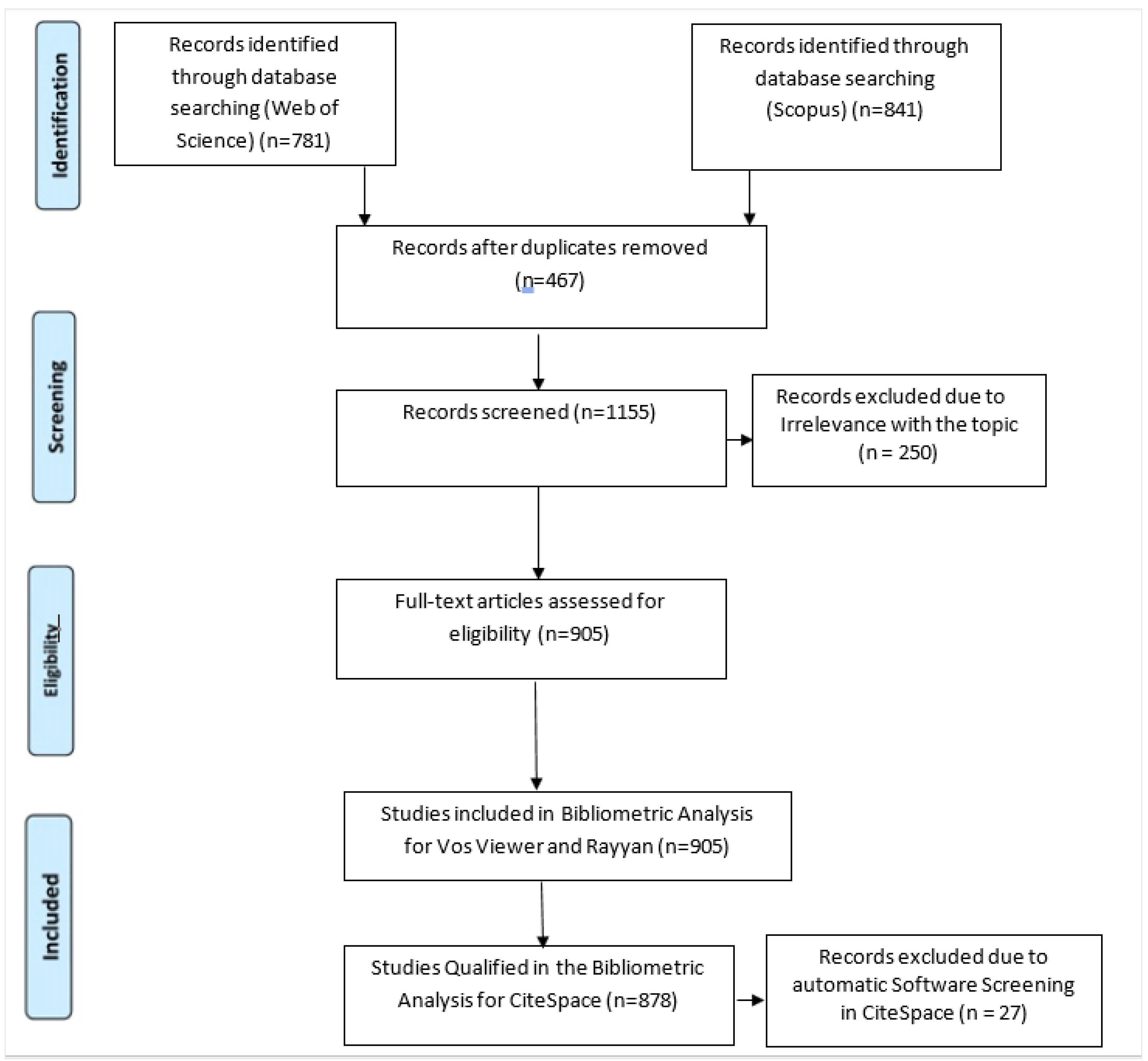
2.2. Data Query and Preparation

The data used in this paper were retrieved from two web-based platforms (Web of Science and Scopus) as these two platforms are the most widely used abstract and citation databases for scientific documents [18]. For both platforms, the search criteria and keywords related to shoreline change detection studies are provided in Table 1 and Table 2.
After completing the initial screening procedure, we exported the selected literature (408 articles) into the EndNote bibliographic reference software for further cleaning of the dataset. In Figure 1, the steps for data cleaning and screening for analysis and visualization is provided. Only peer reviewed journal articles are included in this study. Any duplicate literature was removed using the Zotero bibliographic software. Aided by the use of Rayyan software, a manual screening by going through each article from the selected literature was performed. To ensure appropriate inclusion in the final literature dataset, we inspected each article individually. We decided to use the articles that focused on shoreline change analysis.

3. Results

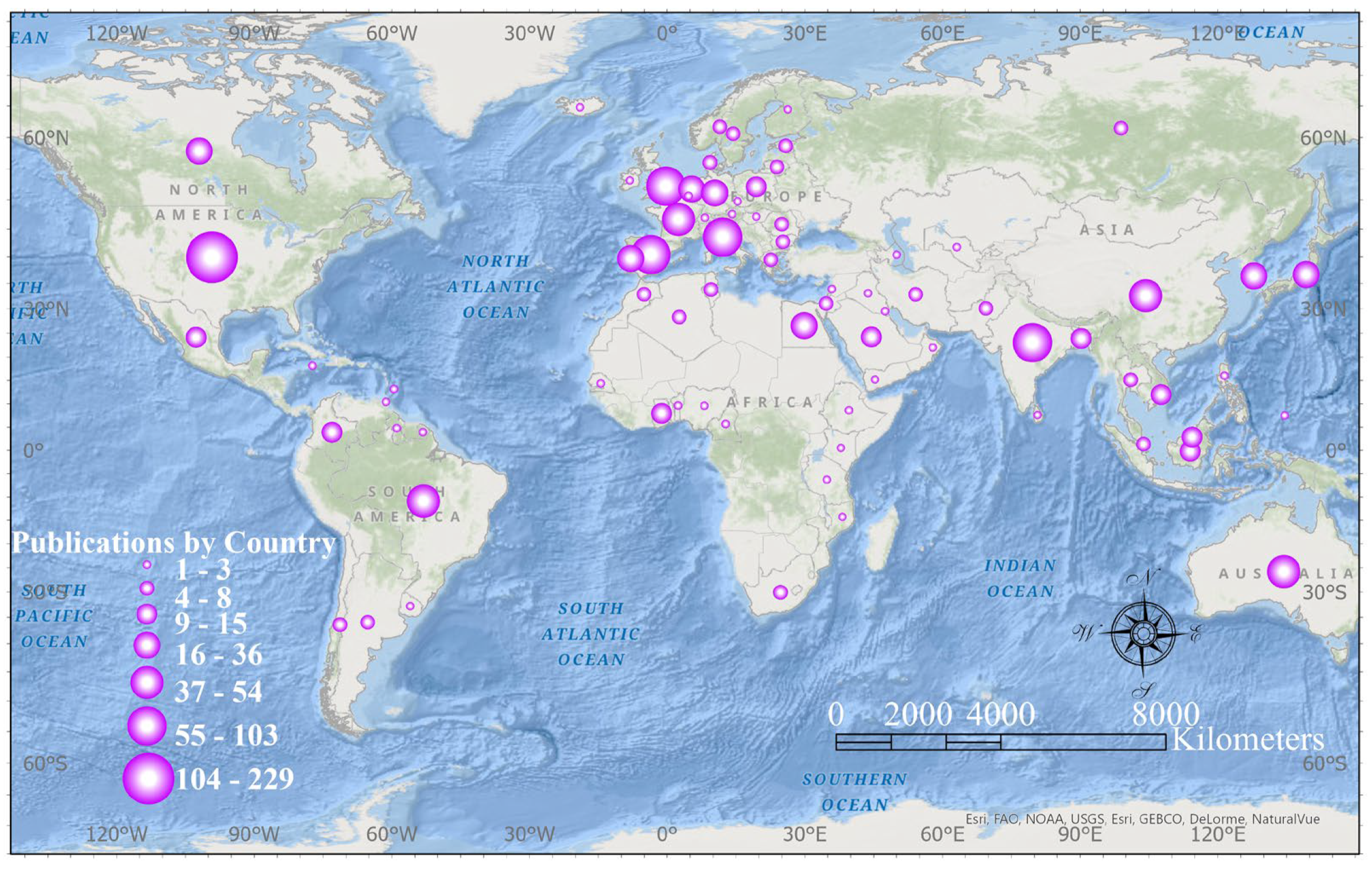
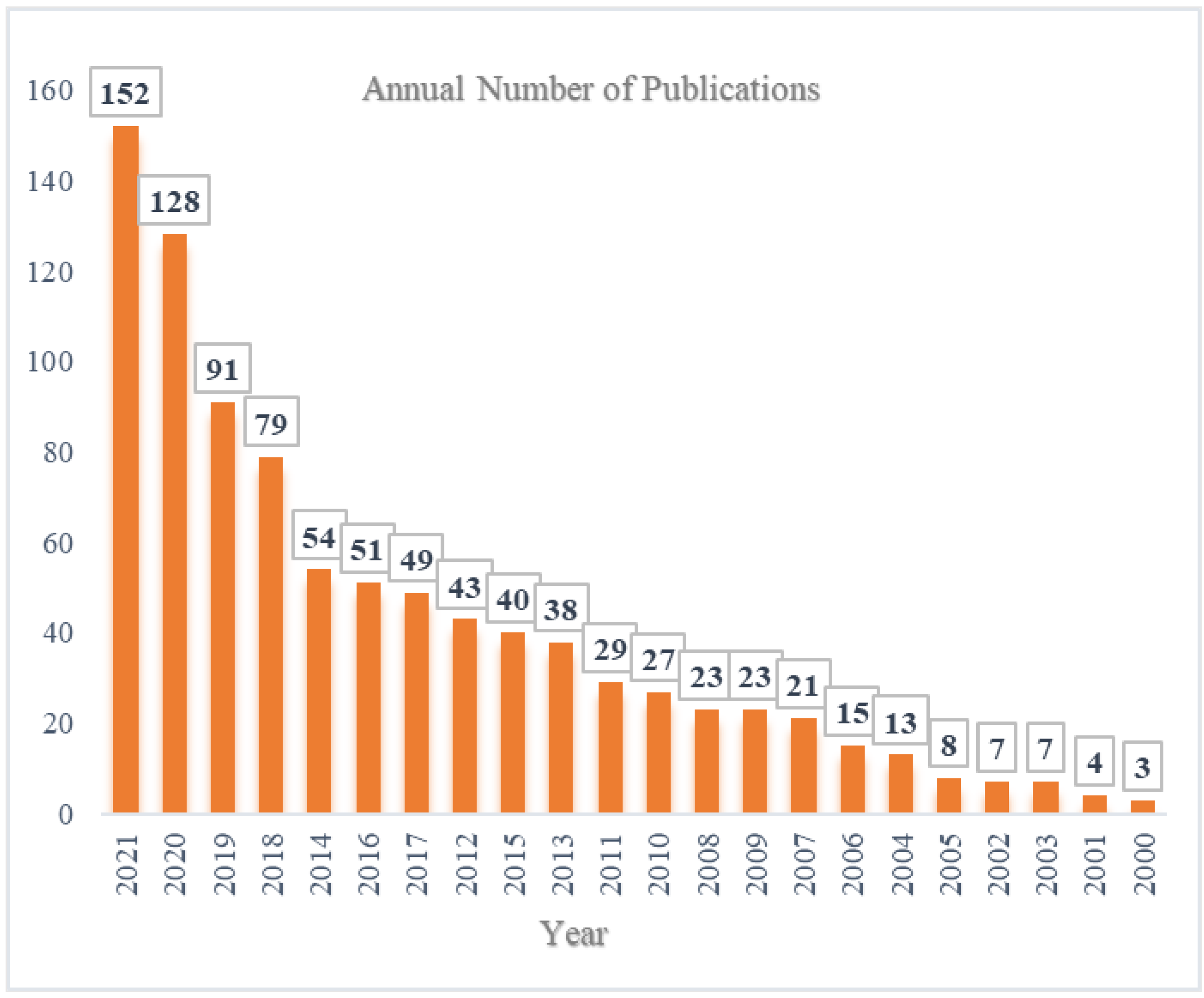
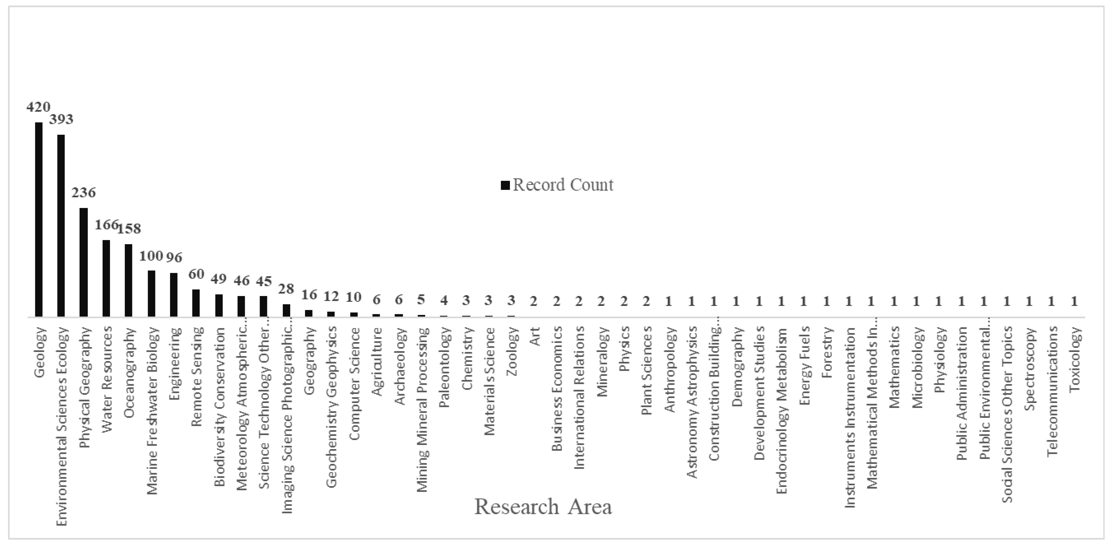
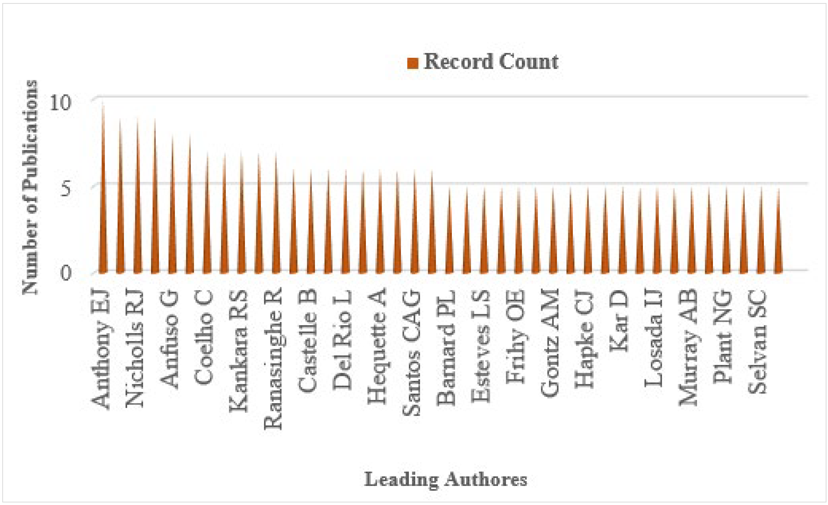
3.1. The Geographic Distribution, Annaul Trend, and Research Area of the Shoreline Change Analysis Literature

The growing literature on studying shoreline change over the last two decades reveals important aspects of the scientific research globally. To understand global spatial patterns in the research literature, it is important to identify country level volumes of literature. Thus, we mapped out all the literature based on individual countries mentioned in the articles to produce a map showing the distribution of the shoreline change studies appearing in the literature during the study period (2000–2021), as shown in Figure 2.
In Figure 3, annual global publication trends are shown from 2000 to 2021. It shows a clear progression of the scientific literature on shoreline change analysis in the recent years leading to 2021. Our results indicate that the publication trend of shoreline change analysis literatures are increasing over time.
Based on the literature records, it can be seen that a wide variety of disciplines have studied shoreline change analysis, and Geology displays the maximum studies, with a record of 420 publication of the 905 total publications, which represents approximately 46 percent of the total publication during the study period. Meanwhile, the combination of Physical Geography (236) and Geography (16) publication records makes up approximately 28 percent of the total number of publications. In Figure 4 research areas are shown.

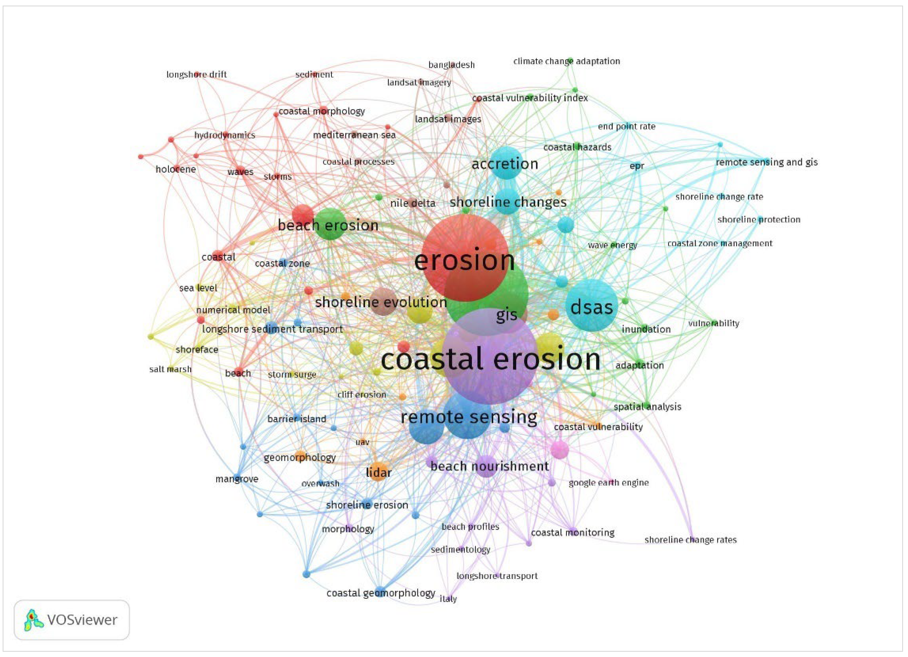
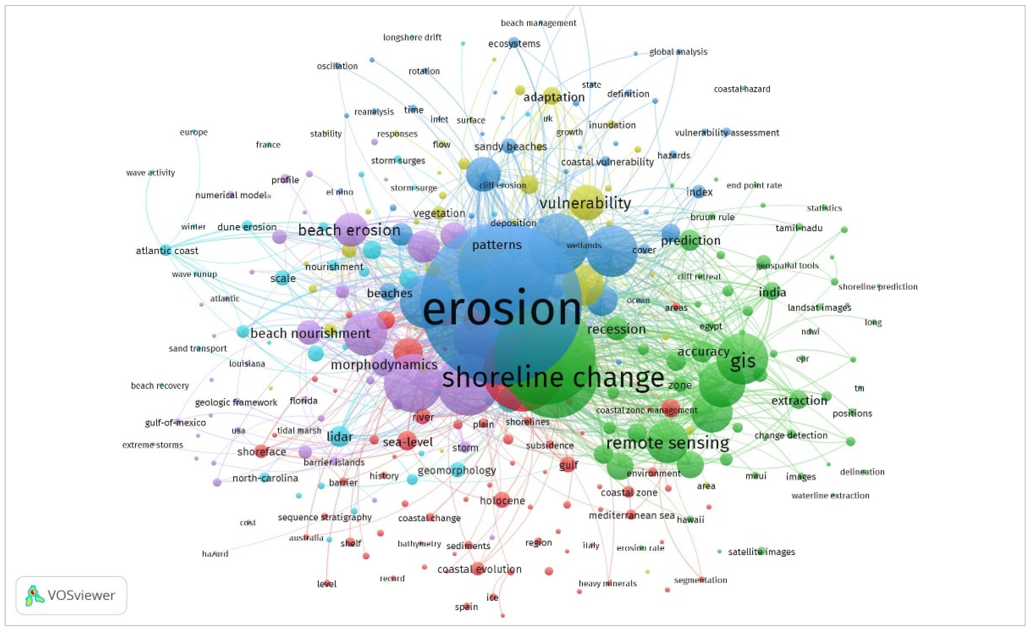
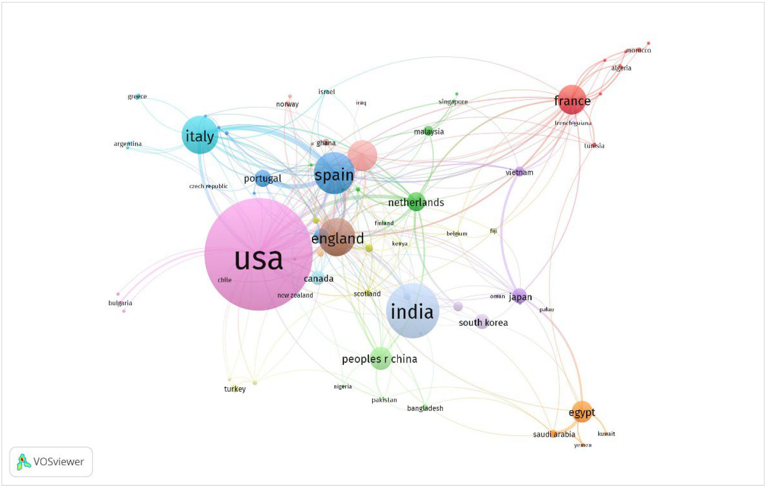
3.2. Co-Occurrences Keywords and Co-Authorship by Country

To visualize the co-occurrences, we chose both author keywords and all keywords. Additionally, we used co-authorship by country. For the author keywords, a total of 155 terms met the criteria based on a minimum of five co-occurrences within the total number of 2446 keywords, where the term coastal erosion appeared 125 times, with a total link strength of 203. In Figure 5, co-occurrences of author keywords are shown.
For all keyword analysis, a total of 329 terms met the criteria based on a minimum of five co-occurrences within the total number of 3897 keywords, where the term coastal erosion appeared 260 times, with a total link strength of 1657. In Figure 6, co-occurrences of all keywords are shown.
For the co-authorship by country, we selected the criteria of minimum number of documents and number of citations of at least one; which resulted in a total of 84 from a list of 86 countries. Based on the analysis, the USA scored top with a total number of documents of 228, with 6121 citations, followed by India, with 103 documents and 1305 citations. Guyana scored the lowest with 1 publication and 2 citations. In Figure 7, co-authorship by countries is shown.
Based on the literature, we attempted to find the leading authors in the subject area. We found that out of the total 905 publications there were 2990 authors who participated in the publication efforts. In Figure 8, we selected the top 20 leading authors who published at least five articles on the topic from 2000 to 2021. The data indicated that Anthony [19] had the highest number of published articles (10).

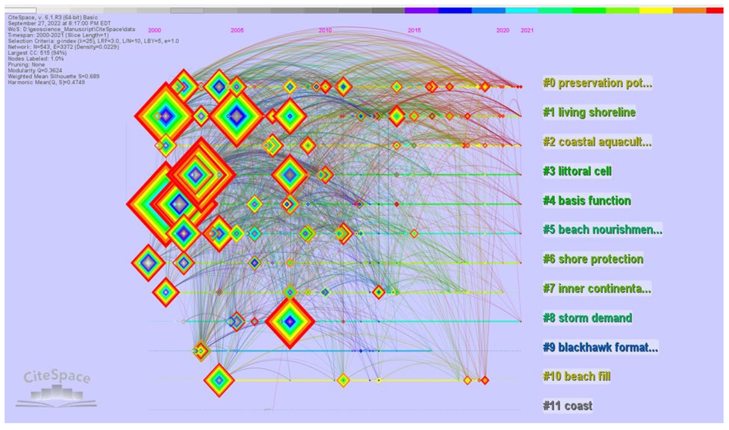
3.3. Text Processing and Clustering Based on Title, Abstract, and Keywords Using the CiteSpace Software

The network consists of 12 clusters shown in Figure 9. The largest 11 clusters are summarized as follows in Table 3.

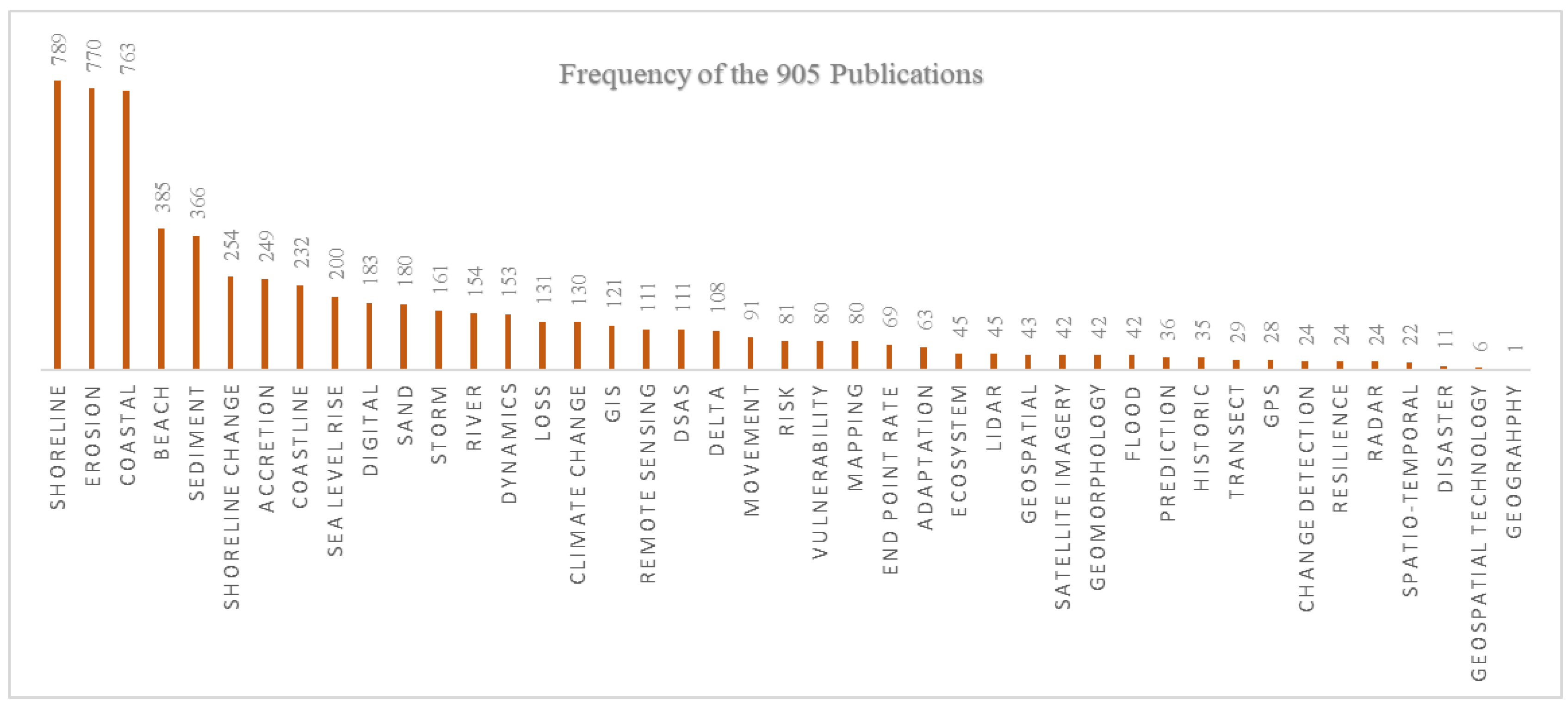
3.4. Selected Keywords Using the Rayyan Bibliographic Analysis

Finally, we decided to use the Rayyan software tool to understand keyword patterns and their frequency. The same dataset was uploaded to the Rayyan online account, and then a list of selected keywords was chosen to see the frequency of the entire literature in the context of Geographic aspects and Geospatial analysis of shoreline change. In Figure 10, selected keywords and frequencies are shown.
It is noteworthy that there could be additional terms to be added to the list. However, we carefully chose the words that align with the geospatial technology and shoreline change related research terms and themes. This could help scholars who are interested in shoreline change analysis and modeling using geospatial technology (GIS and Remote Sensing) as well as those who use machine learning approaches to address the research gaps that exist in the field.

4. Discussion

This study conducts a systematic review and bibliometric analysis of the coastal erosion and shoreline change study literatures during the period 2000–2021. In socioeconomic and environmental terms, review findings are increasingly used in informing better decisions [20]. Systematic reviews of the existing literature are important for rigor and clear accountability in decision making. The review and bibliometric analysis indicate that there is an increasing trend of publication and a clear advancement of the shoreline analysis topic. Based on the Vosviewer output the co-occurrences of author keywords, it can be seen that the terms ‘erosion’ and ‘coastal erosion’ appear as dominating key terms in the literature. Meanwhile, since it became available, the DSAS [21] tool appeared as a leading tool to analyze shoreline changes globally. In general, the overall output of this analysis indicated that the research field focuses on changes globally along the coasts, riverbanks, deltas, and lake shorelines. It is interesting to note that the research field has advanced significantly, with transformations in terms of methodologies, data sources, and the tools used for different types of analysis. Primarily, the majority of the shoreline change studies concentrated on shoreline change detection [22]. In recent years, there is a growing trend to use both Geographic Information Systems (GIS) and Remote Sensing as tools to conduct shoreline change analysis [23]. Based on the selected keyword search using the Rayyan software, we found that the frequency of keywords was as follows: shoreline (789) was the highest, followed by the term erosion (770). However, we found that the terms GIS (121), Remote Sensing (111), and DSAS (111) stood were fairly equal in frequency, while the term Geography (1) scored the lowest in terms of frequency in the 905 publications. Based on the research area, we found Geology (420) was highest in the list, followed by Environmental Sciences Ecology (393) publications during the period. Additionally, based on CiteSpace software (version 6.1.R4, Created: 13 September 2004 Updated: 17 January 2021, 2003–2021 Chaomei Chen, Drexel University, Philadelphia, Pennsylvania, USA); analysis output using all the literature, we found that coastal erosions, shoreline change, sea level rise, and climate change stood as a prime focus of the research domain. Even though coastal communities globally are highly impacted by the shoreline changes, a large group of people suffer and are often rooted out from their original residences due to riverbank erosions within the mainland of many countries, for example, the Jamuna River basin in Bangladesh [24] and the Ganga River basin in India [25]. It is necessary to conduct studies at a country level to acquire a clear picture of the historic shoreline changes, and also to understand the living shorelines and riverbank erosion. Considering both coastal areas as well as those who live in mainland is important for taking adaptation and mitigation measures and adopting new policies by the policy makers and leaders in individual countries in order to minimize socio-economic and environmental impacts associated with both shoreline change and riverbank erosion.
Most of the shoreline change literature is produced by the United States of America (USA) followed by India. It is noteworthy that, due to technological advancement and leading scientific research capacity, the USA remained the leader in the field. Deltas, including the Bengal delta in Bangladesh, the Mekong delta in Vietnam, and the Yellow river delta in China are among the deltas with the highest rates of erosion. Despite being the hotspot of extreme erosion, these places are less studied due to lack of resources. However, to have an impactful growth of the field and a greater positive impact for global communities, it is necessary to have collaborative efforts to conduct studies on the topic, especially with the less developed countries that are highly vulnerable to shoreline movement and global climate change and are impacted by the concerns of rising sea levels [26].
Considering the spatial scale, most studies are either conducted on a small scale, covering a part of a coast/river, or at one side of the shoreline. Previous studies suggest that upstream shoreline conditions may impact the rate of erosion in the downstream. Our previous study found that a concrete revetment protected the shoreline from erosion, but the erosion increased downstream of the revetment [27]. As such, we suggest that larger-scale studies might help in better understanding the situation in the other parts of the same river/delta. Shorelines are very dynamic in nature, especially in a deltaic environment. Most of the existing literatures assessed shoreline change rates at decadal or half decadal scale. Hence, we suggest that shoreline change studies need to take an annual temporal perspective for many areas where shoreline erosions rates are very high and change over time.
Human displacement is one of the most important components of shoreline movement, but a nuanced consideration of displacement is lacking in the coastal shoreline change literature. More in-depth studies with human displacement are suggested for future research. Another important research gap we found in the existing literature is that most of the literature used Landsat satellite data, which has 30m pixel resolution. We suggest that finer resolution data from other sources might help to get better accuracy to detect shoreline movement, though we understand the cost and accessibility issue behind it. Given the advancement in the field, we argue that, in addition to the existing tools and methodology, data for conducting shoreline change analysis, integrating the machine learning (ML) approach and GeoAI (see [28,29]) to excel in the field with higher accuracy, as well as the use of high-resolution imagery (e.g., centimeter level), unmanned aerial vehicles (UAV)/drone technology, and point cloud data, could all be used for both local and global level shoreline change analysis.

5. Conclusions

Based on our review analysis, we found that the majority of the literature on shoreline topics was published in the USA, followed by India and Spain. Additionally, the results indicate a growing trend of the shoreline change study over time. Given the importance of shoreline dynamics, it is essential to continuously monitor and detect spatio-temporal changes of shorelines to keep track of the changes and understand the vulnerability and risks associated with natural disasters and adopt measures for sustainable planning, decision making, and better management practices for the communities impacted by riverbank erosion, as well as coastal erosion, all over the world. It is essential to take proactive measures and adopt appropriate adaptation and mitigation plans for flood management, dam construction, estimation of erosion and accretion rates, modeling of sediment budgets, and predictive modeling of coastal morphological dynamics [30,31].
This comprehensive approach reveals scholarly contributions and trends in the domain of geographic applications in studying the dynamics of shoreline change analysis globally. The results have the potential to inform scholars, practitioners, educators, policy makers, and citizens to gain a better understanding of the topic as well as better understand the global distribution of shoreline change analysis, study patterns, trends, and current key aspects of the shoreline change analysis research activity.

Author Contributions

Conceptualization, review, and editing, T.W.C.; methodology, formal analysis, and original draft preparation, M.K.R.; data preparation and draft preparation, M.S.I. All authors have read and agreed to the published version of the manuscript.

Funding

This research was supported by the U.S. National Science Foundation award #1660447.

Acknowledgments

We are thankful to the reviewers’ comments and feedback.

Conflicts of Interest

The authors declare no conflict of interest.

References

  1. The United Nation’s Ocean Conference. Available online: https://www.un.org/sustainabledevelopment/wp-content/uploads/2017/05/Ocean-fact-sheet-package.pdf (accessed on 3 July 2021).
  2. Nienhuis, J.H.; Ashton, A.D.; Edmonds, D.A.; Hoitink, A.J.F.; Kettner, A.J.; Rowland, J.C.; Tornqvist, T.E. Global-scale human impact on delta morphology has led to net land area gain. Nature 2020, 577, 514–518. [Google Scholar] [CrossRef] [PubMed]
  3. Syvitski, J.P.M.; Kettner, A.J.; Overeem, I.; Hutton, E.W.H.; Hannon, M.T.; Brakenridge, G.R.; Day, J.; Vorosmarty, C.; Saito, Y.; Giosan, L.; et al. Sinking deltas due to human activities. Nat. Geosci. 2009, 2, 681–686. [Google Scholar] [CrossRef]
  4. Tessler, Z.D.; Voeroesmarty, C.J.; Grossberg, M.; Gladkova, I.; Aizenman, H.; Syvitski, J.P.M.; Foufoula-Georgiou, E. Profiling risk and sustainability in coastal deltas of the world. Science 2015, 349, 638–643. [Google Scholar] [CrossRef] [PubMed] [Green Version]
  5. Pelletier, J.D.; Murray, A.B.; Pierce, J.L.; Bierman, P.R.; Breshears, D.D.; Crosby, B.T.; Ellis, M.; Foufoula-Georgiou, E.; Heimsath, A.M.; Houser, C.; et al. Forecasting the response of Earth’s surface to future climatic and land use changes: A review of methods and research needs. Earths Future 2015, 3, 220–251. [Google Scholar] [CrossRef] [Green Version]
  6. Jurasinski, G.; Janssen, M.; Voss, M.; Boettcher, M.E.; Brede, M.; Burchard, H.; Forster, S.; Gosch, L.; Graewe, U.; Gruendling-Pfaff, S.; et al. Understanding the Coastal Ecocline: Assessing Sea-Land Interactions at Non-tidal, Low-Lying Coasts Through Interdisciplinary Research. Front. Mar. Sci. 2018, 5, 342. [Google Scholar] [CrossRef] [Green Version]
  7. Munasinghe, D.; Cohen, S.; Hand, B. Suitability Analysis of Remote Sensing Techniques for Shoreline Extraction of Global River Deltas. IEEE Geosci. Remote Sens. Lett. 2021; unpublished-submitted. Available online: https://eartharxiv.org/repository/view/176/(accessed on 22 June 2022).
  8. Crawford, T.W.; Rahman, M.K.; Miah, M.G.; Islam, M.R.; Paul, B.K.; Curtis, S.; Islam, M.S. Coupled Adaptive Cycles of Shoreline Change and Households in Deltaic Bangladesh: Analysis of a 30-Year Shoreline Change Record and Recent Population Impacts. Ann. Am. Assoc. Geogr. 2021, 111, 1002–1024. [Google Scholar] [CrossRef]
  9. Mentaschi, L.; Vousdoukas, M.I.; Pekel, J.F.; Voukouvalas, E.; Feyen, L. Global long-term observations of coastal erosion and accretion. Sci. Rep. 2018, 8, 12876. [Google Scholar] [CrossRef] [Green Version]
  10. Zhang, K.Q.; Douglas, B.C.; Leatherman, S.P. Global warming and coastal erosion. Clim. Chang. 2004, 64, 41–58. [Google Scholar] [CrossRef]
  11. Lentz, E.E.; Thieler, E.R.; Plant, N.G.; Stippa, S.R.; Horton, R.M.; Gesch, D.B. Evaluation of dynamic coastal response to sea-level rise modifies inundation likelihood. Nat. Clim. Chang. 2016, 6, 696–700. [Google Scholar] [CrossRef]
  12. Van Eck, N.; Waltman, L. Software survey: VOSviewer, a computer program for bibliometric mapping. Scientometrics 2010, 84, 523–538. [Google Scholar] [CrossRef]
  13. Chen, C. System and Method for Automatically Generating Systematic Reviews of a Scientific Field. U.S. Patent 8,566,360, 22 October 2013. [Google Scholar]
  14. Ouzzani, M.; Hammady, H.; Fedorowicz, Z.; Elmagarmid, A. Rayyan—A web and mobile app for systematic reviews. Syst. Rev. 2016, 5, 1. [Google Scholar] [CrossRef] [Green Version]
  15. Ding, X.; Yang, Z. Knowledge mapping of platform research: A visual analysis using VOSviewer and CiteSpace. Electron. Commer. Res. 2020, 22, 787–809. [Google Scholar] [CrossRef]
  16. Al-Ashmori, Y.Y.; Othman, I.; Rahmawati, Y. Bibliographic analysis of BIM success factors and other BIM literatures using Vosviewer: A theoretical mapping and discussion. In Proceedings of the 2nd Joint International Conference on Emerging Computing Technology and Sports (JICETS) 2019, Bandung, Indonesia, 25–27 November 2019; p. 042105. [Google Scholar]
  17. Harrison, H.; Griffin, S.J.; Kuhn, I.; Usher-Smith, J.A. Software tools to support title and abstract screening for systematic reviews in healthcare: An evaluation. BMC Med. Res. Methodol. 2020, 20, 7. [Google Scholar] [CrossRef] [PubMed]
  18. Wang, X.; Fang, Z.; Sun, X. Usage patterns of scholarly articles on Web of Science: A study on Web of Science usage count. Scientometrics 2016, 109, 917–926. [Google Scholar] [CrossRef]
  19. Anthony, E.J.; Brunier, G.; Besset, M.; Goichot, M.; Dussouillez, P.; Nguyen, V.L. Linking rapid erosion of the Mekong River delta to human activities. Sci. Rep. 2015, 5, 1–2. [Google Scholar] [CrossRef] [Green Version]
  20. Halme, P.; Toivanen, T.; Honkanen, M.; Kotiaho, J.S.; Monkkonen, M.; Timonen, J. Flawed meta-analysis of biodiversity effects of forest management. Conserv. Biol. 2010, 24, 1154–1156. [Google Scholar]
  21. Thieler, E.R.; Himmelstoss, E.A.; Zichichi, J.L.; Ergul, A. The Digital Shoreline Analysis System (Dsas) Version 4.0—An Arcgis Extension for Calculating Shoreline Change; No. 2008-1278; US Geological Survey: Reston, VA, USA, 2009.
  22. Morton, R.A.; Miller, T.; Moore, L. Historical shoreline changes along the US Gulf of Mexico: A summary of recent shoreline comparisons and analyses. J. Coast. Res. 2005, 21, 704–709. [Google Scholar] [CrossRef]
  23. Matin, N.; Hasan, G.J. A quantitative analysis of shoreline changes along the coast of Bangladesh using remote sensing and GIS techniques. Catena 2021, 201, 105185. [Google Scholar] [CrossRef]
  24. Islam, M.S.; Matin, M.A. Prediction of fluvial erosion rate in Jamuna River, Bangladesh. Int. J. River Basin Manag. 2022, 19, 1–13. [Google Scholar]
  25. Talukdar, S.; Pal, S.; Singha, P. Proposing artificial intelligence-based livelihood vulnerability index in river islands. J. Clean. Prod. 2021, 284, 124707. [Google Scholar] [CrossRef]
  26. Griggs, G.; Reguero, B.G. Coastal adaptation to climate change and sea-level rise. Water 2021, 13, 2151. [Google Scholar] [CrossRef]
  27. Crawford, T.W.; Islam, M.S.; Rahman, M.K.; Paul, B.K.; Curtis, S.; Miah, M.G.; Islam, M.R. Coastal erosion and human perceptions of revetment protection in the Lower Meghna Estuary of Bangladesh. Remote Sens. 2020, 12, 3108. [Google Scholar]
  28. Udawalpola, M.R.; Hasan, A.; Liljedahl, A.; Soliman, A.; Terstriep, J.; Witharana, C. An Optimal GeoAI Workflow for Pan-Arctic Permafrost Feature Detection from High-Resolution Satellite Imagery. Photogramm. Eng. Remote Sens. 2022, 88, 181–188. [Google Scholar]
  29. Calkoen, F.; Luijendijk, A.; Rivero, C.R.; Kras, E.; Baart, F. Traditional vs. machine-learning methods for forecasting sandy shoreline evolution using historic satellite-derived shorelines. Remote Sens. 2021, 13, 934. [Google Scholar] [CrossRef]
  30. AlBakri, D. A geomorphological approach to sustainable planning and management of the coastal zone of Kuwait. Geomorphology 1996, 17, 323–337. [Google Scholar] [CrossRef]
  31. Cenci, L.; Disperati, L.; Persichillo, M.G.; Oliveira, E.R.; Alves, F.L.; Phillips, M. Integrating remote sensing and GIS techniques for monitoring and modeling shoreline evolution to support coastal risk management. GIScience Remote Sens. 2018, 55, 355–375. [Google Scholar] [CrossRef]
Figure 1. PRISMA flow Diagram for selection of publications for systematic review analysis.
Geosciences 12 00410 g001
Figure 2. Global distribution of shoreline change studies from 2000 to 2021.
Geosciences 12 00410 g002
Figure 3. Yearly shoreline change analysis literature from 2000 to 2021.
Geosciences 12 00410 g003
Figure 4. Research areas between 2000 and 2021.
Geosciences 12 00410 g004
Figure 5. Co-occurrences of author keywords.
Geosciences 12 00410 g005
Figure 6. Co-occurrences of all keywords.
Geosciences 12 00410 g006
Figure 7. Co-authorship by country.
Geosciences 12 00410 g007
Figure 8. Top 20 leading authors with at least five publications in the field.
Geosciences 12 00410 g008
Figure 9. Clustering of Key terms based on title, abstract, and Keywords.
Geosciences 12 00410 g009
Figure 10. Selected keywords from the literature and their frequency.
Geosciences 12 00410 g010
Table 1. The search criteria.
CriterionEligibility
Literature typeJournal (research articles)
LanguageEnglish
TimelineBetween 2000 and 2021
CoverageGlobal
Table 2. Keywords used for finding article from the databases.
Database NameKeywordsPrimaryResultsQuery Link
Web of ScienceTopic search:
“Coastal Erosion and Shoreline Change analysis”
963https://www.webofscience.com/wos/woscc/summary/f2ae0912-72ec-4bee-bc3e-22d593a168bd-510c9f41/relevance/1, last accessed on 22 July 2022
Scopus“Coastal Erosion and Shoreline Change analysis”1362https://www-scopus-com.ezproxy.lib.vt.edu/results/results.uri?sort=tp-t&src=s&sid=4184aa7a495178e999eb3556e134662b&sot=a&sdt=a&cluster=scosubtype, last accessed on 22 July 2022
Table 3. The 11 largest clusters within the network.
ClusterIDSizeSilhouetteLabel (LSI)Label (LLR)Label (MI)Average Year
0690coastline changepreservation potential (1042.19, 0.0001)correlation (0.92)2015
1680living shorelinesliving shoreline (2028.87, 0.0001)correlation (1.38)2013
2580shoreline changescoastal aquaculture (895.27, 0.0001)correlation (0.6)2014
3570shoreline changeslittoral cell (1291.82, 0.0001)correlation (1.46)2008
4540shoreline change ratesbasis function (1091.38, 0.0001)correlation (1.83)2008
5540climate changebeach nourishment (870.67, 0.0001)correlation (1.1)2009
6390shore protectionshore protection (766.06, 0.0001)correlation (0.27)2008
7370coastal plaininner continental shelf (732.04, 0.0001)correlation (0.45)2013
8290coastal erosionstorm demand (751.28, 0.0001)correlation (0.54)2007
9270coastal plainblackhawk formation (402.77, 0.0001)correlation (0.21)2007
10190sea-level risebeach fill (701.66, 0.0001)correlation (0.28)2013
Publisher’s Note: MDPI stays neutral with regard to jurisdictional claims in published maps and institutional affiliations.

