1. Introduction
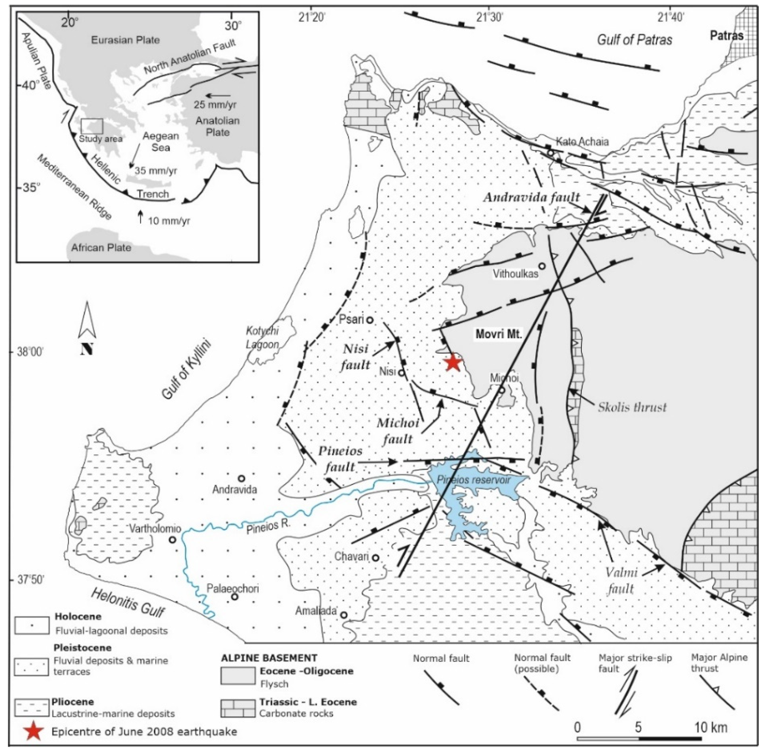
The region of Greece and of the surrounding areas (
Figure 1, inset) is characterized by high seismicity level [
1]. This is documented by a variety of data including instrumental earthquake records obtained in the post-1900 period as well as historical documents and geological evidence [
2,
3,
4,
5,
6,
7,
8,
9]. In spite of the large amount of data accumulated, there is still a significant lack of knowledge about past earthquakes that occurred in Greece not only in the historical period but also in the early era of instrumental seismology. Therefore, the lack of knowledge calls for the reappraisal of strong, damaging earthquakes. For example, a recent re-examination of the earthquakes of 8 November 1905 in Northern Greece and of 23 April 1933 in the Southeastern Aegean Sea proved quite productive in better understanding the events and their impact in both the human and the natural environment [
10,
11].
One of the destructive earthquakes that occurred in Greece in the early instrumental period is that of 2 July (O.S.)/15 July (N.S.) 1909, where (O.S.) and (N.S.) stand for Old Style (Julian) and New Style (Gregorian) calendars, respectively. This earthquake, measuring a moment magnitude of M
w5.92 according to the ISC-GEM determinations [
12], ruptured the province of Elis, NW Peloponnese (
Figure 1), which has been frequently hit by destructive earthquakes in the past [
5,
6,
8,
13,
14,
15,
16,
17,
18]. However, the 1909 earthquake remains a little-known event in the seismological tradition. This is attributed to that only a small fraction of the available documentary sources was collected and utilized so far.
The main objective of this paper is to re-examine the 1909 earthquake in the light of several documentary sources and seismic records which have not been used before. We show that the 1909 earthquake caused not only extensive building destruction and many fatalities but also a variety of ground failures. Based on the new observational material collected, we assigned seismic intensities in several Intensity Observation Points (IOPs), drew isoseismals and determined the macroseismic epicenter and magnitude of the earthquake. This study is a contribution toward a better understanding of the earthquake itself and its effects in the built and the natural environment, as well as of the seismic history of the area. In addition, this paper offers new data for the enrichment of the ground failures data sets collected so far in Greece.
2. Geological Setting and Previous Studies
2.1. Geology and Seismicity
The surface geology of the Elis basin in NW Peloponnese (
Figure 1) is characterized by the accumulation of post-Miocene sediments exceeding 1700 m in thickness [
19,
20]. Since the Holocene, the Elis basin accumulated fluvial deposits, mainly sands and gravels, supplied by the river system of the area [
21,
22,
23]. From a geomorphological point of view, the Elis basin is interpreted as a large fluvial to marine terrace.
The study area is characterized by a complex tectonic regime (
Figure 1). Offshore the area is dominated by the motion of the African plate, which underthrusts beneath NW Peloponnese from approximately SW to NE. The tectonics in the study area is complicated and the current deformation is accommodated mainly by active normal and strike-slip faults. Normal faults are trending at approximately WNW or WSW [
19,
20,
23,
24]. On the other hand, buried faults inferred from seismicity also play an important role in the active tectonics of the area. This is the case of the Andravida dextral strike-slip fault associated with the strong Movri Mountain earthquake (M
w6.38) of 8 June 2008 [
12,
15,
16,
17,
18,
25] (
Figure 1 and
Figure 2). The 2008 earthquake did not rupture at the Earth’s surface and, therefore, the causative blind fault has been inferred only from fault-plane solutions and aftershock distribution (e.g., [
15,
16,
17,
18,
25]). A surface fault trace of limited length and attaining a maximum offset of ~25 cm, which appeared with the 2008 earthquake, constitutes only re-activation of the subsidiary Nisi Fault (
Figure 1) that can be considered as a splay of the main fault at depth [
26]. Fault plane solutions [
27] indicated that the moderate earthquake (M
w5.63, [
12]) of 2 December 2002 (
Figure 2) was associated with a possibly sinistral strike-slip fault.
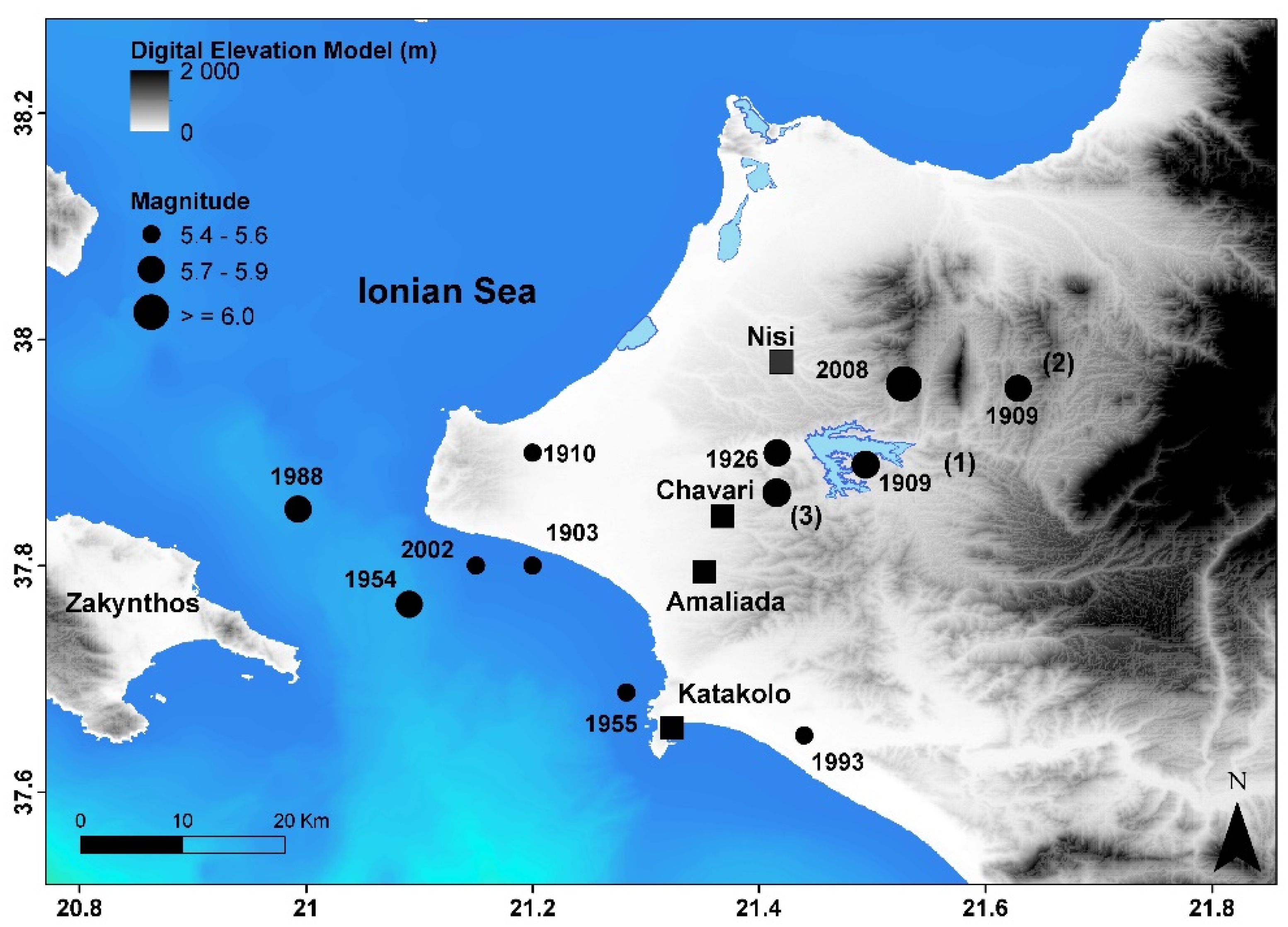
The Elis area is characterized by high seismicity. A total of 10 moderate-to-strong earthquakes occurred either on land or offshore in about the last 120 years (
Table 1,
Figure 2). In the historical period, Elis was also hit by strong earthquakes [
2,
6,
8]. Although the 1909 earthquake was included in some earthquake catalogs, it was examined shortly only in a few scientific studies [
13,
28,
29,
30,
31,
32,
33]. Books that are still widely used as reference publications for Greek earthquakes of minimum magnitude 6.0 [
5,
6], do not list that event.
2.2. Previous Studies of the 1909 Earthquake
2.2.1. Macroseismic Intensity
A maximum macroseismic intensity as low as I
max = V in the 10-grade Rossi–Forel (RF) scale was initially reported by the National Observatory of Athens (NOA) [
28]. Intensity V in RF scale corresponds also to degree V in the 12-grade Mercalli-Modified (MMI) and EMS-98 scales according to a comparison study of macroseismic intensity scales [
39]. However, intensity V underestimated drastically the earthquake impact and should be attributed to the fact that the earthquake impact was reported by local observers of NOA established only away from the meizoseismal area of the earthquake. In later catalogs press reports published in the capital city of Athens were considered. The I
max assigned ranged between IX and X degrees either in the MMI or in the EMS-98 scales [
2,
29,
30,
31]. The previous authors assigned macroseismic intensities in various observation points but ignored local press reports, which contain valuable information regarding the impact of the 1909 earthquake and its associated phenomena. Therefore, significant room exists for the reexamination of the earthquake intensity field.
2.2.2. Epicenter Determination
An instrumental epicenter was initially determined from 12 records at remote European stations [
32] (
Table 1). This epicenter falls close to the today Pineios water reservoir (
Figure 2) and was later adopted in other earthquake studies [
32,
33]. However, from the same seismic records a significantly different epicenter has been determined in the ISC-GEM catalog [
12] (
Table 1). The epicentral distances of the stations used range from 6.39° (station SAR) to 22.07° (station UPP). However, the stations’ azimuthal coverage is bad since all stations fall in the NW quadrant of the sphere. It has been noted [
40] that since hypocenters in the first part of the 20th century have been the most vulnerable to large location errors, before their inclusion in the ISC-GEM catalog [
12] they have been manually reviewed for every single event occurring between 1903 and 1930. In a later section we redetermine the earthquake epicenter from the macroseismic observations collected.
2.2.3. Magnitude Determination
Kárnik [
32] utilized instrumental records from the 12 European stations mentioned before and calculated proxy surface-wave magnitude M
s5.7, which was adopted by others [
32,
33]. An initial magnitude of M
s5.74 (±0.12) was obtained from the same records before its inclusion in the ISC-GEM catalog [
12] (Dr. D. Di Giacomo, ISC, personal communication). Then, based on empirical M
s/M
w relationships [
41] an M
w proxy of 5.92 ± 0.2 was calculated and inserted in the published ISC-GEM catalog [
12].
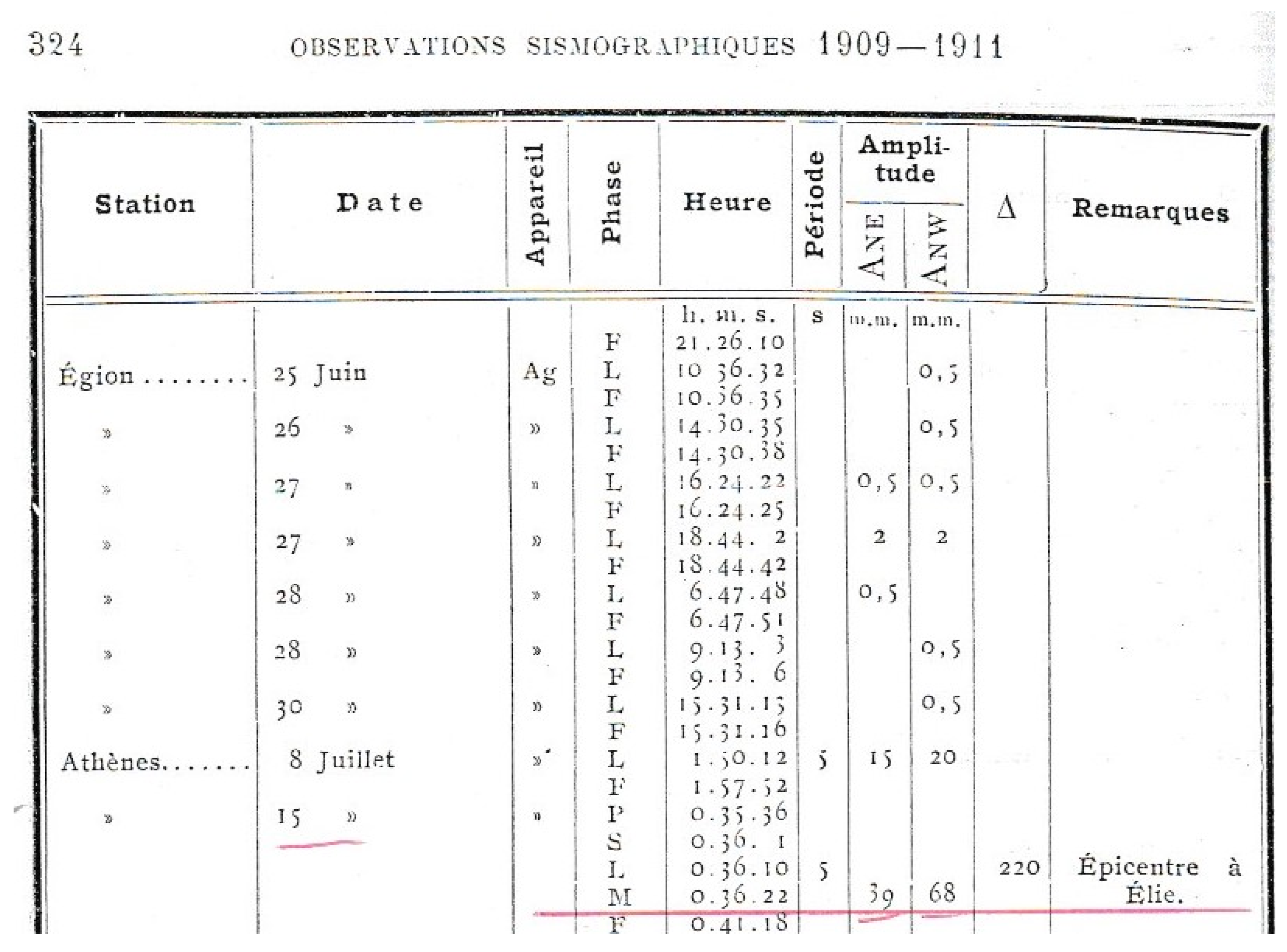
Five primitive Agamennone-type seismographs were in operation in various places of Greece in the time interval from 1900 until 1910. The relevant seismic record parameters were published in the Bulletins of NOA [
28]. These instruments had as a common feature an intermediate natural period ranging from ~4.0 s to 6.5 s. Thanks to this feature, a proxy M
s re-calculation has been possible [
42] for earthquakes occurring in Greece at that time interval. Trace wave amplitudes of 52 earthquakes of M
s ≥ 5.0, recorded by Agamennone seismographs from 1900 to 1910, were utilized for the first time to re-calculate M
s proxy magnitudes [
42] through a calibration over M
s determined at NOA from post-1910 records in Mainka and Wiechert seismographs. This has been made possible due to that these seismographs had natural period nearly identical to the period of the Agamennone instruments. The only Agamennone instrument of two horizontal components that recorded the 15 July 1909 earthquake was the one that operated at the seismological station of Athens (ATH). Parameters of the relevant seismic record are illustrated in
Figure 3.
Good correlation was found [
42] between the re-calculated surface-wave magnitudes and the magnitudes estimated in previous catalogs (e.g., [
33]) for 51 out of 52 earthquakes. The only outlier has been the re-calculated M
s proxy for the 15 July 1909 earthquake. Magnitude M
s6.6 was found [
42] for epicentral distance Δ = 192 km from the station ATH and for the trace wave amplitudes shown in
Figure 3. The epicenter adopted for this calculation is that determined by [
32] (
Table 1). The result does not change substantially if Δ = 180 km is taken by adopting the epicenter determined in the ISC-GEM catalog [
12]. A plausible explanation for the outlier is that either the reading of the trace wave amplitudes or the registration of them in the Bulletin of NOA was erroneous. The earthquake magnitude has been recalculated in a next section based on the macroseismic data collected.
3. Materials and Methods
3.1. Sources and Documentation
To further study the 1909 earthquake we collected and examined contemporary archives, press reports, and books, which have not been utilized in previous studies. The new information sources used provided descriptions of the earthquake effects in the built environment and in the ground as well as photographs illustrating building damage (
Figure 4).
A valuable source of historical information about the earthquake phenomena occurring in Greece is the unpublished manuscript “Book of Earthquakes, NOA (1893–1915)” [
43] consisting of two volumes covering the time intervals 1893–1901 and 1902–1915. The material collected for this book was based on the macroseismic observations performed by local observers affiliated to NOA. Another primary source collected is the archive of a contemporary local writer and eyewitness of the earthquake [
44]. Of interest is also an earlier report by the same author [
45] regarding the local seismicity in the study area. Press reports, which have not been used so far in the seismological literature, have been taken from local newspapers published in the cities of Amaliada, Patras, and Pyrgos in the aftermath of the earthquake. Our collection also included newspapers published in Athens as well as correspondences of “The New York Times.” A full list of the press reports consulted can be found in the
Appendix A.
In the newspapers collected, we found not only press correspondences about the earthquake and its impact but also other types of relevant material including (1) reports of administrative persons, such as the head of Elis Prefecture and Mayors of the area, (2) accounts of various eyewitnesses, and (3) extensive parts of the scientific report submitted to the central government at Athens by Dr. Th. Skoufos, Professor of Geology at the University of Athens (e.g., newspaper Proodos, Amaliada city, 27 July 1909, N.S.). This report was based on the post-event field survey conducted by Th. Skoufos, which hereinafter is referred to as [
46]. Unfortunately, we were unable to locate the original report submitted. Other sources about the 1909 earthquake and its impact are the books published by a local author [
47,
48,
49], who collected press reports, eyewitness accounts, and photographs illustrating the destruction caused.
The entire set of macroseismic observations we collected for the 1909 earthquake is categorized in three subsets (
Table 2). The first was organized by us from the local documentary sources compiled, which are referring to the earthquake impact mainly in the near-field domain, i.e., in a radius of ~30 km around the meizoseismal area of Chavari village. Another subset of macroseismic observations includes the intensities assigned to several IOPs based on observations collected by local observers affiliated to NOA [
28]. This subset of IOPs refers to only the far-field domain. The third subset of IOPs published by others [
31] has not been based on local documentary sources but only on press reports published in newspapers of Athens and referring to both the far-field and near effects of the earthquake.
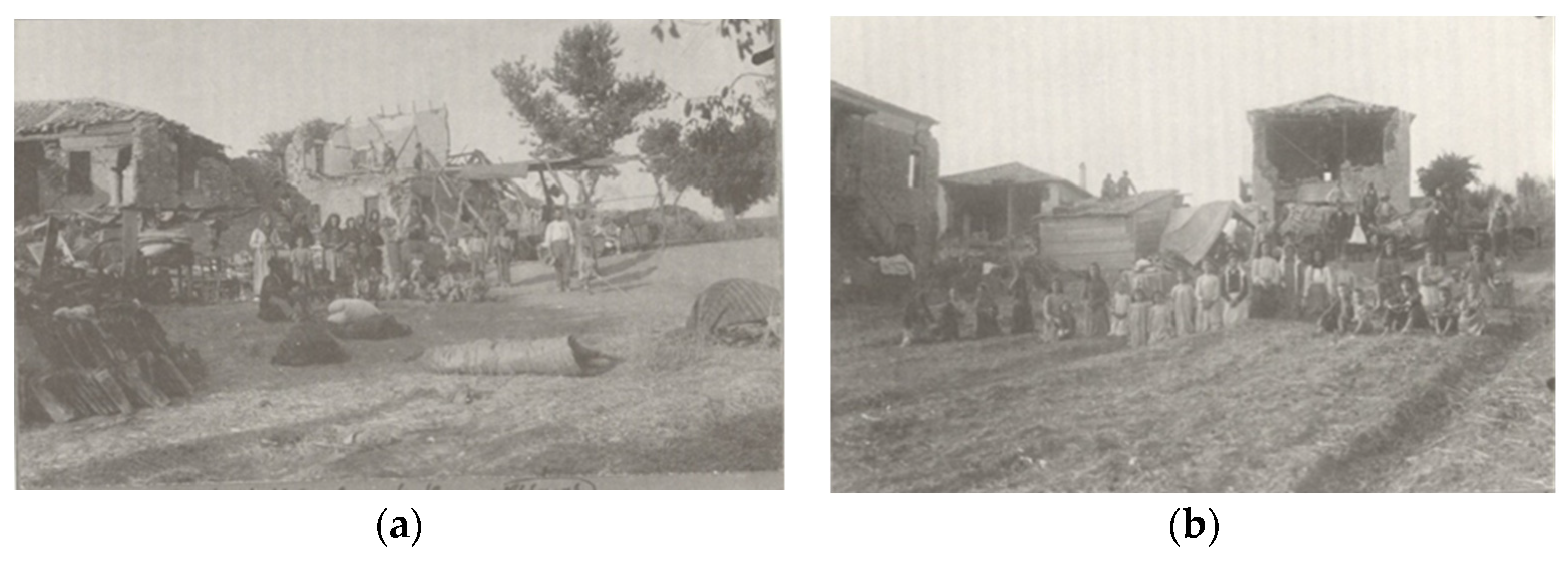
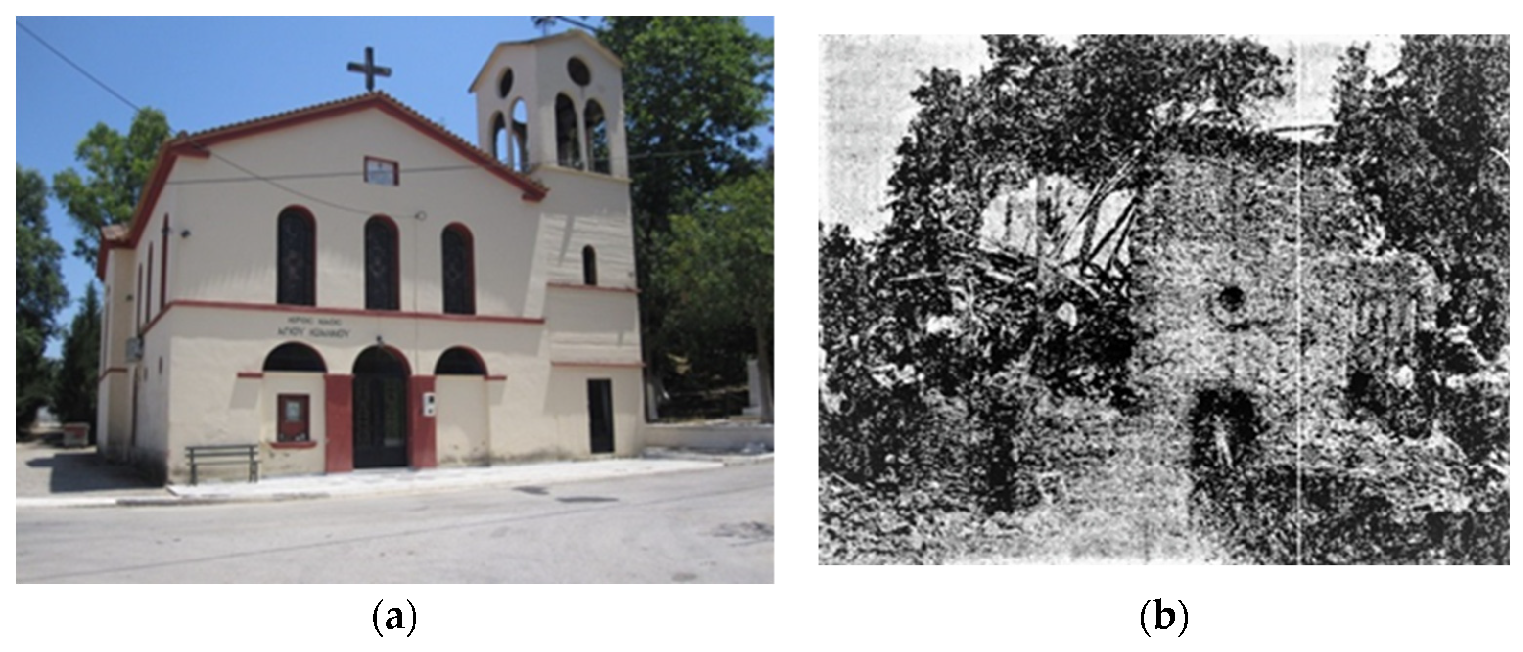
On 11 and 12 June 2018, we performed a field survey in the meizoseismal area of the 1909 earthquake. However, we were unable to find evidence of co-seismic surface fault-trace. The only piece of evidence found and related to the earthquake impact was the Aghios (St.) Ioannis church situated very close to Chavari village in the meizoseismal area. This church (
Figure 5a) was constructed in replacement of the previous (
Figure 5b) that was ruined by the earthquake.
3.2. Intensity Assignment
From the set of observations compiled we assigned intensity level in several IOPs (
Table 2) based on descriptions regarding the earthquake impact in the built environment and the earthquake perceptibility. The approach used included the next stages: (i) collection of macroseismic observation data for each single observation point, e.g., town, village, settlement, (ii) control of the consistency of data retrieved from different sources for each observation point, and (iii) intensity assignment for each point according to the 12-point EMS-98 scale. A similar approach was followed by other authors (e.g., [
51]). The intensities adopted from NOA [
28] were initially assigned according to the 10-point Rossi–Forel scale. Therefore, we transformed them to intensities in EMS-98 scale according to a thorough comparison of macroseismic intensity scales [
39]. Intensities published by others [
31] were organized in EMS-98 scale by the respective authors.
3.3. Isoseismals and Macroseismic Epicenter
Drawing of reliable isoseismals for earthquake damage sparsely observed in a region is a long-standing problem. This is the case of the 15 July 1909 earthquake not only because of the sparsity of damage data but also because of the presence of sea near the earthquake area. In such cases the technique of natural-neighbor (n-n) isoseismals has been proposed as a new and effective tool for mapping objective and reproducible isoseismals [
52,
53]. Relevant algorithms use the n-n coordinates for weighting, interpolating, and contouring the earthquake felt reports. Based on the n-n technique, we were able to draw a map of the 1909 earthquake isoseismals by utilizing the set of IOPs compiled in
Table 2. The center of gravity of the isoseismal of maximum degree has been adopted as the macroseismic epicenter of the earthquake.
3.4. Fatalities
The various estimations about the earthquake mortality concluded with contradictory numbers of fatalities ranging from 25 to 45 and up to 70. However, no official report about the earthquake impact has been found. Therefore, our evaluation of the earthquake mortality was based on the set of documentary sources collected, which is the most complete compiled for this earthquake so far. The uncertainties faced are various, e.g., the numbers of human victims and injuries are diverging not only in press reports published in different newspapers but also in different reports that appear even in a single newspaper publication. On the other hand, the fatality numbers are coincident in two or more newspaper publications, very likely because the correspondent was the same person. Another issue is that the numbers of fatalities published in press reports changed with time. Namely, the later estimates have been more reliable since the fatality counts in short time after a catastrophic event are not cross-checked and therefore, usually are exaggerated. Our fatalities estimation considered the above issues and was concluded after cross-checking the various documentary sources examined.
3.5. Macroseismic Magnitude Determination
The magnitude estimation of earthquakes occurring in the historical period as well as in the early instrumental era of seismology is a quite challenging issue. Of particular value is to compare results obtained from different methods. The instrumental magnitude determinations of the 15 July 1909 earthquake were found to not deviate significantly since they range from M
s5.7 to M
w5.92. However, the 1909 earthquake is a good case to test the consistency of instrumental and macroseismic magnitude estimations. To this aim we used empirical magnitude/intensity relationships established for instrumental shallow earthquakes occurring in Greece in the time interval from 1911 to 2005. Two types of such relationships were obtained through linear regression [
9,
54]:
and
I
max is the maximum epicentral intensity and A
i is the surface area within the contour of intensity of i degree; α and b are coefficients determined from the data. Relationships of both types were successfully tested with data of the period 2006–2011. Three groups of relationships for each one of the two types were produced for earthquakes occurring inland, in coastal areas, and offshore. The reason is that the location of the epicenter of historical and early instrumental earthquakes is susceptible to high uncertainty. This important issue has also been discussed by other authors (e.g., [
55,
56]). In our case, there is no doubt that the earthquake under examination has been associated with an inland rupture.
The set of empirical relationships used for the magnitude determination of the 1909 earthquake are listed in
Table 3. The first relationship in this Table was applied by considering an intensity numerical value equal to 9.5, which corresponds to intensity between IX and X degrees. The rest of relationships were applied by considering the surface areas A
i, and the area covered by the isoseismals of IV, V, VI, VII, and VIII degrees. The area A
i for each isoseismal was estimated with the GIS calculate geometry tool by consedering not only the land coverage of the isoseismals but also their theoretical continuation over the sea.
4. Results
4.1. Building Damage and Fatalities
According to the documentary sources we collected, the 15 July 1909 main shock caused partial or total collapse of many buildings, such as schools, churches, houses, and governmental buildings, mainly in Chavari and in the surrounding villages including Bezaiti (Κeramidia), Damiza (Daphne), Lopesi (Kryoneri), Marinaki (Aghios Dimitrios), Palaeopolis (Ilida), and Bouchioti (Avgeion). It has also been reported that besides the houses that fell, the Roman walls of the Palaeopolis village fell, too. However, we were unable to verify an accurate number of buildings suffering significant damage as we found no relevant official reports. Numbers that one may find in press reports and in other sources examined are often confusing and/or contradictory.
The estimated number of fatalities was found as high as 55 from which 25 were counted in Chavari village. We were also able to estimate a total number of 284 injuries.
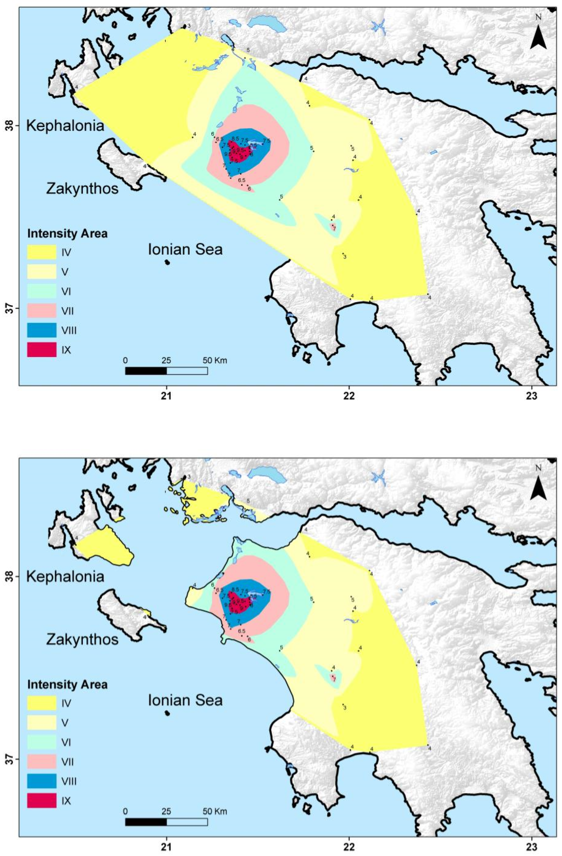
4.2. Isoseismal Mapping and Macroseismic Epicenter
With the application of the n-n technique to the data set of IOPs listed in
Table 2, we draw the isoseismals of the 1909 earthquake. The upper panel of
Figure 6 shows the isoseismals on land and their extension in the sea area. The isoseismals covering only the land are shown in the lower panel of
Figure 6. The earthquake macroseismic magnitude has been estimated from the isoseismals covering both the land and the sea with the use of the empirical relationships (2–6) listed in
Table 3. It is evident that the isoseismal of IX degree is the contour of maximum intensity area.
The gravity center of this area represents the macroseismic epicenter of the earthquake, which falls in the area of Chavari village. For reasons of better visualization, the macroseismic epicenter has been plotted in
Figure 2. In documentary sources, it has been reported that in the area of Chavari the earthquake shook vertically upwards, while the duration of the Earth’s shaking was very short. These two features are consistent with a local source of moderate magnitude.
4.3. Magnitude Determination
The macroseismic earthquake magnitude was determined as the average of six single magnitude estimations (
Table 3) and was found equal to 5.9 ± 0.4 proxy M
s. This magnitude estimation is consistent with the instrumental magnitudes determined by other authors.
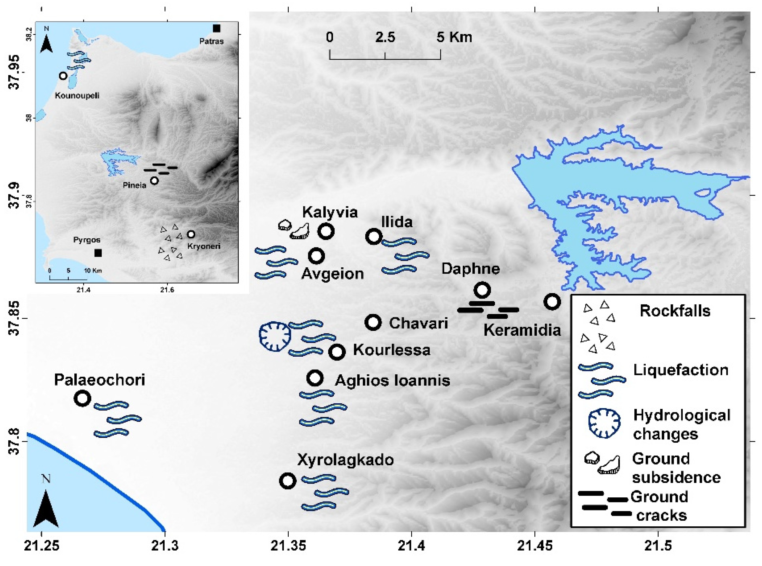
4.4. Co-Seismic Ground Failures
The documentary sources examined provided details on a variety of co-seismic phenomena observed in many localities of the study area. The phenomena included hydrological changes and various ground failures, such as surface manifestations of soil liquefaction, rock falls, subsidence, fissures, and cracks (
Table 4,
Figure 7).
The earthquake-associated phenomena were observed mainly in the epicentral area, i.e., close to the villages of Chavari and Κeramidia as well as in observation sites situated as far as ~25 km from the macroseismic epicenter. It is noteworthy that the generation of hydrological changes and ground failures was favored by the soil conditions because the area is covered by loosely connected fluvial deposits and a very shallow water table. In Chavari village, two quarters of the village were reportedly split by a series of ground ruptures. However, we doubt if these ruptures have been surface traces of the seismogenic fault. The various types of co-seismic phenomena reported, and the respective observation points are listed in
Table 4.
4.5. Precursory Phenomena
Macroscopic anomalies preceding strong earthquakes have been reported in China, Japan, and other seismogenic regions of the Earth [e.g., [
57]], including the Mediterranean region and Greece [
58]. In the press reports collected, we found claims for a variety of macroscopic precursory phenomena preceding the strong earthquake of 15 July 1909. These included luminous and acoustic phenomena, e.g., underground roars, as well as uneasy behavior of animals, such as horses and cuts. For example, eyewitnesses reported that near the village of Chavari the earthquake was preceded by a terrible underground roar and luminous phenomena in the sky. A huge flash of lightning was also seen in the horizon from Amaliada town to Katakolo village (localities shown in
Figure 2). The earthquake came immediately after the occurrence of the luminous phenomena. The various precursors reported were observed in or close to the meizoseismal area. No short-term foreshock activity was reported before the main shock. It is of interest, however, that a local writer [
45] reported on a few shocks felt in the area on 30 March 1905.
5. Conclusions
The earthquake of 15 July 1909 is a characteristic example of a destructive event of which, however, remained little-known so far. The study of this earthquake completes our knowledge of the early instrumental seismicity in the NW Peloponnese area, Greece.
From the set of documentary sources compiled we concluded that the 1909 earthquake caused extensive destruction in houses, churches, and other buildings particularly in Chavari and the surrounding villages. We estimated that 55 people were killed and another 284 injured. The maximum intensity was estimated as high as IX degree on the EMS-98 scale. We constructed earthquake isoseismals and the center of gravity of the isoseismal of highest degree (IX) was considered as the macroseismic epicenter, which falls in Chavari. From macroseismic intensities we calculated a proxy surface-wave magnitude of Ms5.9, which is close to the Ms5.74 and Mw5.92 calculated by other authors who utilized seismic records in remote European stations.
Various macroscopic precursors were observed just before the 1909 earthquake occurrence, such as earthquake lights, acoustic phenomena, and anomalous animal behavior. The earthquake caused various ground failures such as soil liquefaction, rock falls, ground fissures, and cracks as well as a variety of hydrological changes. However, no surface fault-trace was reported, which implies that the investigation of the causative blind fault in the future should be based on a multidisciplinary approach by utilizing field data, appropriate maps, geodetic and 3D seismological data, structural field survey, and morphometric analysis.
Author Contributions
Conceptualization, I.T.; methodology, I.T., I.K., G.A.P. and E.L.; investigation, I.T., I.K. and G.A.P.; writing—original draft preparation, I.T.; writing—review and editing, all authors; visualization, I.T. All authors have read and agreed to the published version of the manuscript.
Funding
The first author was supported by the Hellenic Foundation for Research and Innovation (HFRI) and by the General Secretariat for Research and Technology (GSRT), under the HFRI PhD Fellowship grant (GA. no. 490).
Data Availability Statement
Details on the data sources used are provided in the main text.
Acknowledgments
Τhe first author was supported by the Hellenic Foundation for Research and Innovation (HFRI) and by the General Secretariat for Research and Technology (GSRT), Greece, under the HFRI PhD Fellowship grant (GA. no. 490). We are grateful to D. Di Giacomo (ISC) for communicating details on the magnitude calculation procedure of the 15 July 1909 earthquake.
Figure 1,
Figure 2,
Figure 6 and
Figure 7 were created using the ArcGIS
® software, version 10.8 by Esri.
Conflicts of Interest
The authors declare no conflict of interest.
Appendix A
Press reports consulted in this study. Publication year of all reports is 1909. Dates are in O.S. unless otherwise indicated. The city of publication is shown in parentheses.
Local press: Neologos and Peloponnisos (Patras), 4 July; Anagennisis (Pyrgos) 20 and 24 July; Proodos (Amaliada), 27 July
Athens press: Akropolis, 3 and 4 July; Athinai, 3 and 5 July; Empros, 3 and 6 July; Kairoi Athinon, Neon Asty, 4 July; Skrip, 4 and 8 July; Chronos, 5 and 6 July.
International press: The New York Times, 16, 17 and 18 July (N.S.).
References
- Båth, M. The seismology of Greece. Tectonophysics 1983, 98, 165–208. [Google Scholar] [CrossRef]
- Galanopoulos, A.G. Greece—A Catalog of Shocks with I≥VI or M≥5 for the Years 1801–1958; University of Athens: Athens, Greece, 1960; p. 119. [Google Scholar]
- Galanopoulos, A.G. Greece—A Catalog of Shocks with Io≥VII for the Years Prior to 1800; University of Athens: Athens, Greece, 1961; p. 19. [Google Scholar]
- Guidoboni, E.; Comastri, A.; Traina, G. Catalog of Ancient Earthquakes in the Mediterranean Area up to the 10th Century; Istituto Nazionale di Geofisica –Storia Geofisica Ambiente: Rome, Italy, 1994; p. 504. [Google Scholar]
- Papazachos, B.C.; Papazachou, C. The Earthquakes of Greece; Ziti Publisher: Thessaloniki, Greece, 1997; p. 304. [Google Scholar]
- Papazachos, B.C.; Papazachou, C. The Earthquakes of Greece; Ziti Publisher: Thessaloniki, Greece, 2003; p. 286. (In Greek) [Google Scholar]
- Guidoboni, E.; Comastri, A. Catalog of Earthquakes and Tsunamis in the Mediterranean Area from the 11th to the 15th Century; Istituto Nazionale di Geofisica –Storia Geofisica Ambiente: Rome, Italy, 2005; p. 1037. [Google Scholar]
- Ambraseys, N.N. Earthquakes in the Mediterranean and Middle East, A Multidisciplinary Study of Seismicity up to 1900; Cambridge University Press: Cambridge, UK, 2009; p. 947. [Google Scholar]
- Papadopoulos, G.A. Earthquakes and Tsunamis in Crete: The Hellenic Arc, 2000 BC–AD 2010; Ocelotos Publisher: Athens, Greece, 2011; p. 415. [Google Scholar]
- Triantafyllou, Ι.; Zaniboni, F.; Armigliato, A.; Tinti, S.; Papadopoulos, G.A. The Large Earthquake (~M7) and its Associated Tsunami of 8 November 1905 in Mt. Athos, Northern Greece. Pure Appl. Geoph. 2020, 177, 1267–1293. [Google Scholar] [CrossRef]
- Triantafyllou, Ι.; Papadopoulos, G.A.; Lekkas, E. Impact on built and natural environment of the strong earthquakes of April 23, 1933 and July 20, 2017, in the southeast Aegean Sea, eastern Mediterranean. Nat. Hazards 2019, 100, 671–695. [Google Scholar] [CrossRef]
- International Seismological Centre. ISC-GEM Earthquake Catalog; v.8.0; International Seismological Centre: Newbury, UK, 2021. [Google Scholar]
- Galanopoulos, A.G. Die Seismizität von Elis. Gerl. Beitr. Geoph. 1940, 56, 92–107. [Google Scholar]
- Galanopoulos, A.G. The Damaging shocks and the Earthquake Potential of Greece. Ann. Geol. Pays Hellen. 1981, 30, 648–724. [Google Scholar]
- Koukouvelas, I.; Kokkalas, S.; Xypolias, P. Surface deformation during the Mw6.4 (8 June 2008) Movri Mountain earthquake in the Peloponnese, and its implications for the seismotectonics of western Greece. Intern. Geol. Rev. 2009, 52, 249–268. [Google Scholar] [CrossRef]
- Ganas, A.; Serpelloni, E.; Drakatos, G.; Kolligri, M.; Adamis, I.; Tsimi, C.; Batsi, E. The Mw6.4 SW-Achaia (Western Greece) earthquake of 8 June 2008: Seismological, field, GPS observations, and stress modeling. J. Earthq. Engin. 2009, 13, 1101–1124. [Google Scholar] [CrossRef]
- Papadopoulos, G.A.; Karastathis, V.; Kontoes, C.; Charalampakis, M.; Fokaefs, A.; Papoutsis, I. Crustal deformation associated with East Mediterranean strike-slip earthquakes: The 8 June 2008 Movri (NW Peloponnese), Greece, earthquake (Mw6.4). Tectonophysics 2010, 492, 201–212. [Google Scholar] [CrossRef]
- Karakostas, V.; Mirek, K.; Mesimeri, M.; Papadimitriou, E.; Mirek, J. The Aftershock Sequence of the 2008 Achaia, Greece, Earthquake: Joint Analysis of Seismicity Relocation and Persistent Scatterers Interferometry. Pure Appl. Geoph. 2017, 174, 151–176. [Google Scholar] [CrossRef]
- Kamberis, E. Geologic and Oil-Geologic Study of the Post-Alpine Sediments of NW Peloponnese. Ph.D. Thesis, National Technical University of Athens, Athens, Greece, 1987; p. 143. (In Greek). [Google Scholar]
- Koukouvelas, I.; Mpresiakas, A.; Sokos, E.; Doutsos, T. The tectonic setting and earthquake ground hazards of the 1993 Pyrgos earthquake, Peloponnese, Greece. J. Geol. Soc. 1996, 153, 39–49. [Google Scholar] [CrossRef]
- Kelletat, D.; Kowalczyk, G.; Schroeder, B.; Winer, K.P. A synoptic view on the neotectonic development of the Peloponnesian coastal regions. Zeit. Deutsche Geolog. Res. 1976, 127, 447–465. [Google Scholar] [CrossRef]
- Hageman, J. Benthic foraminiferal assemblages from Plio–Peistocene open bay to lagoonal sediments of the western Peloponnesus (Greece). Utrecht Micropaleont. 1979, 20, 1–172. [Google Scholar]
- Kamberis, G.; Ioakim, C.; Tsaila-Monopoli, S.; Tsapralis, V. Geodynamic and paleogeographic evolution of western Peloponnesus (Greece) during the Neogene. Paleont. I Evol. 1992, 24–25, 363–376. [Google Scholar]
- Fountoulis, I.; Mavroulis, S.; Vassilakis, E.; Papadopoulou-Vrynioti, K. Shoreline displacement and Pineios River diversions in NW Peloponnese (Greece) as result of the geology, active tectonics and human activity during the last 100 ky. Zeit. Geom. 2013, 57, 97–123. [Google Scholar] [CrossRef]
- Konstantinou, K.I.; Evangelidis, C.P.; Melis, N.S. The 8 June 2008 Mw 6.4 Earthquake in Northwest Peloponnese, Western Greece: A Case of Fault Reactivation in an Overpressured Lower Crust? Bull. Seismol. Soc. Am. 2011, 101, 438–445. [Google Scholar] [CrossRef]
- Zygouri, V.; Koukouvelas, I.K.; Kokkalas, S.; Xypolias, P.; Papadopoulos, G.A. The Nisi Fault as a key structure for understanding the active deformation of the NW Peloponnese, Greece. Geomorphology 2015, 237, 142–156. [Google Scholar] [CrossRef]
- Roumelioti, Z.; Benetatos, C.; Kiratzi, A.; Stavrakakis, G.; Melis, N. A study of the 2 December 2002 (M5.5) Vartholomio (western Peloponnese, Greece) earthquake and of its largest aftershocks. Tectonophysics 2004, 387, 65–79. [Google Scholar] [CrossRef]
- Eginitis, D. Observations macroseismiques 1909–1911. Ann. Observ. Nat. d’ Athènes 1912, 6, 309–310. [Google Scholar]
- Galanopoulos, A.G. A Seismic Geography of Greece (Sismiki Geografia tis Ellados). Ann. Geogol. Pays Hellen. 1955, 6, 83–121, (In Greek with English abstr). [Google Scholar]
- Shebalin, N.V. (Ed.) Atlas of Isoseismal Maps: III. UNDP-UNESCO Survey of the Seismicity of the Balkan Region; UNESCO: Skopje, Yugoslavia, 1974; p. 275. [Google Scholar]
- Misailidis, G.; Kouskouna, V.; Papadimitriou, E. Revisiting the Vartholomio (W. Peloponnese) damaging earthquakes since 1909-A macroseismic approach. In Proceedings of the 2nd European Conference on Earthquake Engineering and Seismology, Istanbul, Turkey, 25–29 August 2014; pp. 1–13. [Google Scholar]
- Kárník, V. Seismicity of the European Area, Part 2; Reidel: Dordrecht, The Netherlands, 1969; p. 218. [Google Scholar]
- Comninakis, P.E.; Papazachos, B.C. A Catalog of Earthquakes in Greece and the Surrounding Area for the Period 1901–1980; Publication of the University of Thessaloniki, Geophys Lab: Thessaloniki, Greece, 1986; Volume 1, p. 167. [Google Scholar]
- Global Centroid-Moment-Tensor (GCMT) Project. Available online: https://www.globalcmt.org/ (accessed on 15 May 2022).
- Makropoulos, K.; Kaviris, G.; Kouskouna, V. An updated and extended earthquake catalog for Greece and adjacent areas since 1900. Nat. Haz. Earth Syst. Sci. 2012, 12, 1425–1430. [Google Scholar] [CrossRef] [Green Version]
- National Observatory of Athens. Available online: http://www.gein.noa.gr/en/seismicity/earthquake-catalogs (accessed on 15 May 2022).
- Papadopoulos, G.A.; Profis, T. Macroseismic observations related with the strong shock of 16 October 1988, in NW Peloponnesus, Greece: The important role of the microzonation conditions. J. Geodynamics 1990, 12, 217–231. [Google Scholar] [CrossRef]
- Papadopoulos, G.A.; Fountoulis, D.; Grivas, K. The 26 March 1993 earthquake in the area of Pyrgos, NW Peloponnese, Greece: Earthquake engineering aspects. In Proceedings of the 2nd Workshop on Statistical Models & Methods in Seismology-Application on Prevention & Forecasting of Earthquakes, Cephalonia, Greece, 2–5 June 1993; Papadopoulos, G.A., Makropoulos, K.C., Eds.; National Observatory of Athens: Athens, Greece, 1994; pp. 208–235. [Google Scholar]
- Musson, R.M.W.; Grünthal, G.; Stucchi, M. The comparison of macroseismic intensity scales. J. Seismol. 2010, 14, 413–428. [Google Scholar] [CrossRef] [Green Version]
- Bondár, I.; Engdahl, E.R.; Villasenor, A.; Harris, J.; Storchak, D. ISC-GEM: Global Instrumental Earthquake Catalog (1900–2009), II: Location and seismicity patterns. Phys. Earth Planet. Inter. 2015, 239, 2–13. [Google Scholar] [CrossRef] [Green Version]
- Di Giacomo, D.; Bondár, I.; Storchak, D.A.; Engdahl, E.R.; Bormann, P.; Harris, J. ISC-GEM: Global Instrumental Earthquake Catalog (1900–2009), III. Re-computed Ms and mb, proxy Mw, final magnitude composition and completeness assessment. Phys. Earth Planet. Inter. 2015, 239, 33–47. [Google Scholar] [CrossRef]
- Triantafyllou, Ι. Impact of Earthquakes in Greece from the Antiquity up to Now: Database Development and Space-Time Distribution with GIS Tools. Ph.D. Thesis, University of Athens, Athens, Greece, 2021; p. 210. [Google Scholar]
- Anonymous. Book of Earthquakes:1902–1915; National Observatory of Athens: Athens, Greece. unpublished (In Greek)
- Laskaris, N. Lasta and Its Monuments (I Lasta kai ta Mneimia tis); Varouxis Publisher: Pyrgos, Greece, 1910; Volume 6, pp. 1–582. (In Greek) [Google Scholar]
- Laskaris, N. Lasta and Its Monuments (I Lasta kai ta Mneimia tis); Varouxis Publisher: Pyrgos, Greece, 1906; Volume 3, pp. 118–289. (In Greek) [Google Scholar]
- Skoufos, T. A Report on the 15 July 1909 Earthquake (Ekthesi gia to Seismo tis 15 Iouliou 1909); Newspaper Proodos: Amaliada, Greece, 1909. (In Greek) [Google Scholar]
- Dimitropoulos, M.G. Chavari and Its People (To Chavari kai oi Chavaraioi); Kyttaro Publisher: Pyrgos, Greece, 1991; p. 372. (In Greek) [Google Scholar]
- Dimitropoulos, M.G. Historical Dictionary of Elis Province (Istoriko Lexiko tis Eparchias Elias); Koulis Publisher: Patras, Greece, 2017; Volume 1, pp. 1–556. ISBN 978-618-83201-3-0. (In Greek) [Google Scholar]
- Dimitropoulos, M.G. Historical Dictionary of Elis Province (Istoriko Lexiko tis Eparchias Elias); Koulis Publisher: Patras, Greece, 2017; Volume 2, pp. 557–1105. ISBN 978-618-83201-4-7. (In Greek) [Google Scholar]
- Newspaper “Skrip”, 8 July 1909 (O.S.), Athens, publisher G. Efstratiades.
- Azzaro, R.; Barbano, M.S.; Tertulliani, A.; Pirrotta, C.A. A Reappraisal of the 1968 Valle Del Belice Seismic Sequence (Western Sicily): A case study of Intensity Assessment with Cumulated Damage Effects. Ann. Geophys. 2020, 63, SE105. Available online: https://www.annalsofgeophysics.eu/index.php/annals/article/view/8308 (accessed on 5 September 2022). [CrossRef]
- Sirovich, L.; Pettenati, F.; Cavallini, F.; Bobbio, M. Natural-neighbor isoseismals. Bull. Seismol. Soc. Am. 2002, 92, 1933–1940. [Google Scholar] [CrossRef]
- Sirovich, L.; Pettenati, F.; Cavallini, F. Intensity-based source inversion of the destructive earthquake of 1694 in the southern Apennines, Italy. J. Geophys. Res. Solid Earth 2013, 118, 6241–6257. [Google Scholar] [CrossRef]
- Fokaefs, A.; Roussopoulou, C.; Papadopoulos, G.A. Magnitudes of historical Greek earthquakes estimated by magnitude/ intensity relationships. In Proceedings of the 5th International Symposium on the Eastern Mediterranean Geology, Thessaloniki, Greece, 14–20 April 2004; Volume 2, pp. 568–571. [Google Scholar]
- Tinti, S.; Vittori, T.; Mulargia, F. Regional intensity-magnitude relationships for the Italian territory. Tectonophysics 1986, 127, 129–154. [Google Scholar] [CrossRef]
- Guidoboni, E.; Ebel, J.E. Earthquakes and Tsunamis in the Past–A Guide to Techniques in Historical Seismology; Cambridge University Press: Cambridge, UK, 2009; p. 590. [Google Scholar]
- Rikitake, T. Earthquake Forecasting and Warning; Developments in Earth and Planetary Sciences-Center for Academic Publications, D. Reidel Publishing Company: Tokyo, Japan, 1982; Volume 3, p. 402. [Google Scholar]
- Papadopoulos, G.A. Luminous and fiery phenomena associated with earthquakes in the East Mediterranean. In Atmospheric and Ionospheric Electromagnetic Phenomena Associated with Earthquakes; Hayakawa, M., Ed.; TERRA Publications: Tokyo, Japan, 1999; pp. 559–575. [Google Scholar]
| Publisher’s Note: MDPI stays neutral with regard to jurisdictional claims in published maps and institutional affiliations. |
© 2022 by the authors. Licensee MDPI, Basel, Switzerland. This article is an open access article distributed under the terms and conditions of the Creative Commons Attribution (CC BY) license (https://creativecommons.org/licenses/by/4.0/).


 ,
, 


