1. Introduction: The 2007 Western Solomon Islands Earthquake and Tsunami, and the Scope and Purpose of the Paper
This paper considers a range of disaster risk reduction issues related to the April 2007 tsunami in the Western Solomon Islands. The paper focuses on the island of Ghizo (
Figure 1), where community-related research was undertaken over an extensive 4-year period. This work explores an experience of differentiated mortality: how one ethnic group was disproportionally affected, in terms of population numbers, by deaths caused by the 2007 tsunami. However, this is just one aspect of the paper. The paper also explains how an understanding of the causes of differential mortality connects directly to the experiences of different groups in a syn- to post-disaster environment and sheds light on the variable community resilience and adaptation during the post-disaster period. The research was undertaken some years after the actual 2007 tsunami, allowing the researchers to build upon the work of immediate post-disaster workers, and assess the longer-term differences for the various communities that were affected by the tsunami. The paper connects what happens during the immediate post-disaster moments with the evolution of the same communities during later periods. It thus valuably demonstrates how the factors that affect differential morbidity within different social groups
also impact upon medium- to longer-term post-disaster adaptation, including addressing the broader questions of how best to promote and support livelihoods/disaster subcultures in regions of high tsunami risk.
While this paper is being published in a journal with a largely geoscientific readership, the authors are cognizant that it will be available and read by a much wider audience, which includes the many disciplines that support disaster and risk reduction (DRR) work. Geoscientists are key to DRR: they assess and monitor hazards, generate geohazard data, maps and models, and develop a myriad of documents and tools that attempt to mitigate risk. Increasingly, however, geoscientists work within interdisciplinary and trans-disciplinary teams, involving social scientists, DRR managers, health professionals and scientists, aid and disaster agencies, governments at national and regional levels, international agencies, and so on. This paper documents the results of an interdisciplinary team involving a geoscientist and three social scientists who have practical experience in addressing DRR in the field and disaster-prevalent situations. These experiences have encouraged the authors to write a paper for publication within a Geoscience journal to showcase a case study with international applications that has benefitted from a trans-disciplinary research approach. The paper clearly shows, for example, how geoscience and geohazard communications must take account of the probability that the same geohazard will variably impact different social groupings, with implications including the development of increasingly sophisticated approaches to geohazard communication for heterogeneous communities.
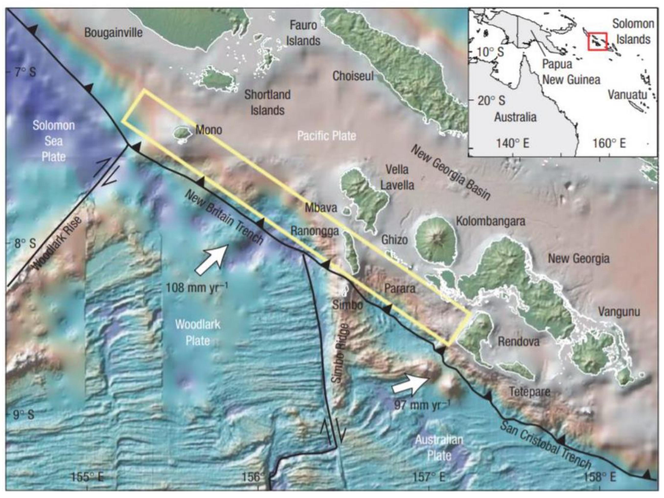
This paper focuses on the response to a tsunami disaster on Ghizo Island, located in the Western Province of Solomon Islands in the southwest Pacific (
Figure 1). On 2 April 2007, at 07:39 a.m. local time, an earthquake with an epicentre 40 km south–southwest of Ghizo Island, magnitude 8.1, depth 10 km, struck the region (
Figure 1,
Table 1). The earthquake was tsunamogenic, with tsunamis affecting the coastal regions of Western Province islands such as Simbo, Vella Lavella, Ranonga, Kolombangara, and New Georgia. Tsunami run-ups were up to 12 m high. The tsunami hit Ghizo around five minutes after the earthquake occurred. Fifty-two people were killed as a direct result of the tsunami, of whom 33 were from Ghizo (with Simbo being the next highest casualty island, with ten deaths). Of the 33 deaths on Ghizo, 31 were from the Gilbertese community, a migrant Micronesian community from Kiribati, which transmigrated during British colonial times. Readers are directed to [
1,
2,
3,
4,
5,
6] for further details of the earthquake and tsunami.
This paper results from extensive fieldwork undertaken between 2011 and 2013 on Ghizo. The fieldwork involved close participatory disaster social scientific research with a focus on four village communities, two of which were Gilbertese and two of which were Melanesian, the majority community of the Ghizo and Solomon Islands.
All the ethnographic research exercises undertaken for this project were designed to explore a series of research questions, intended to shed light on the reasons that 94% of the deaths from the 2007 Western Solomon tsunami on Ghizo were from the relatively small migrant Gilbertese community, and why so few deaths occurred within the majority Melanesian community. Scholars such as Fritz and Kalligeris [
7] and MacAdoo et al. [
3,
4] have examined this issue and concluded that the role of indigenous knowledge, ancestral heritage, and local geomorphology are key explanations for this conundrum. While earlier work from Hagen [
8] agreed, to an extent, with the conclusions of MacAdoo and Fritz and colleagues, she also suggested the need to examine a more complex and multifaceted set of reasons that include livelihood variability and strength. This paper examines these issues in more depth, drawing from Hagen’s PhD thesis [
9] and presenting a brief history and analysis of Gilbertese migration, Melanesian and Gilbertese society, a robust methodology for research,
and results that shed light on community resilience, immediate disaster response, the period immediately following the tsunami, and longer-term community adaptations. The research demonstrates that migrant communities may have a series of different vulnerabilities that require urgent responses, and that resilience to disasters within and between communities is dependent on a range of interconnecting phenomena, from livelihood diversity to village location, power hierarchies, ethnic tensions, and land rights and tenureship.
2. Experiences of Migration: I-Kiribati and Gilbertese Communities within the Pacific Region
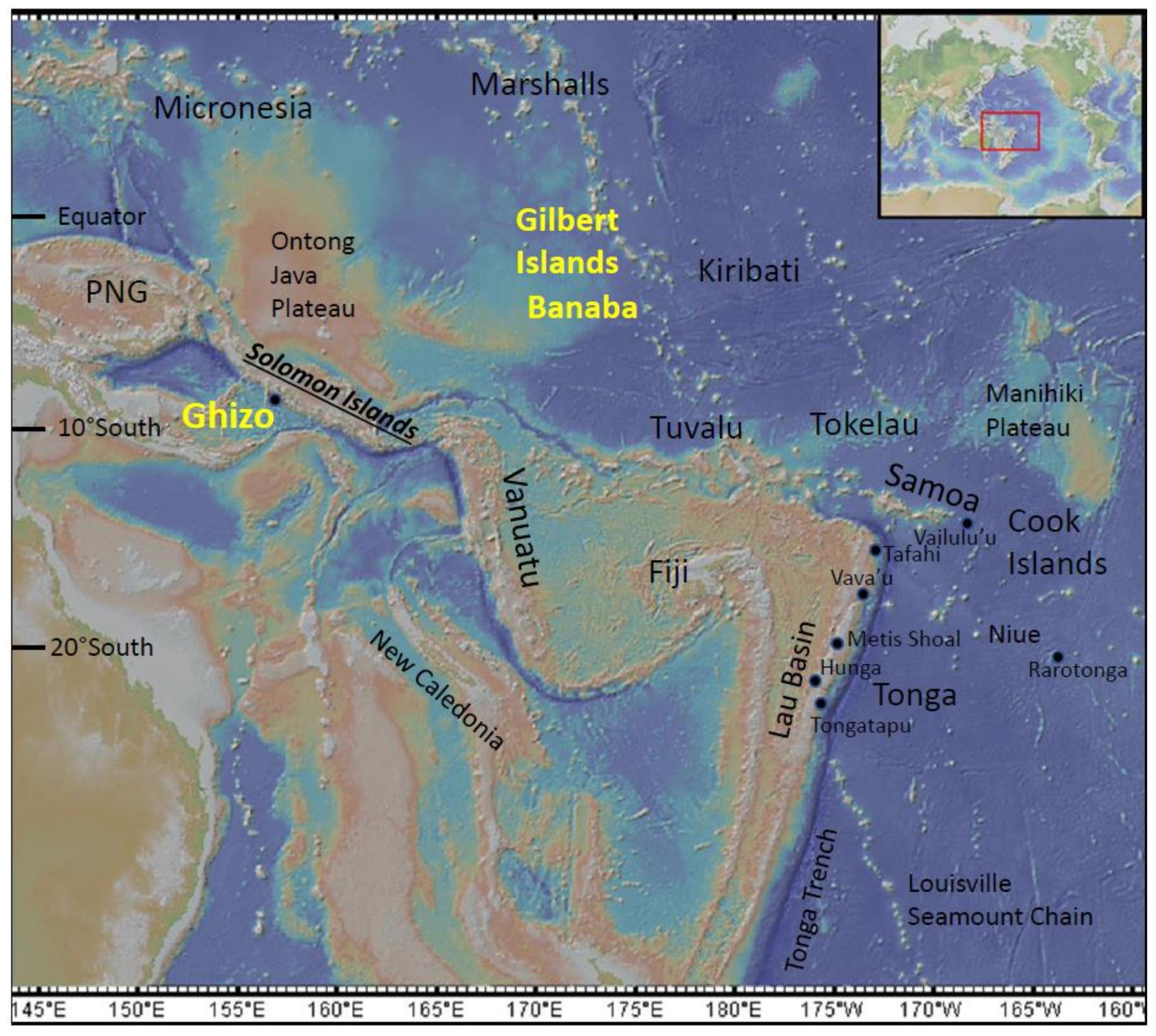
To better understand how the tsunami had such disparate impacts on adjacent communities, it is important to understand the complexity of the Gilbertese community’s migration to the Solomon Islands (
Figure 2). The Gilbertese, or I-Kiribati, are named in reference to their ancestral home-islands, which were called the Gilbert Islands by the British during colonial times, when the British governed the modern states of Kiribati and Tuvalu as the ‘Gilbert & Ellice Islands’. The Gilbert Islands form one group of islands within modern Kiribati (
Figure 2). These islands contain the majority of the population, including South Tarawa, the capital atoll. Gilbertese people were resettled in the Solomon Islands and Fiji from the 1940s to the 1970s. For a range of reasons such as marginalisation, relative poverty and discrimination by the host majority, migrant communities can suffer disproportionately from the impacts of natural disasters [
10]. This section briefly documents two examples of migration from Kiribati. The differences between migrant Gilbertese and indigenous Melanesian communities on Ghizo will be examined throughout this paper. This section provides a contextual background.
Over 1000 people were forcibly moved from Banaba (formerly Ocean Island, an upraised reef island within Kiribati, which became a phosphate mine,
Figure 2) to Rabi Island, Fiji, in 1945 [
11,
12]. Other I-Kiribati/Gilbertese people were re-settled in Solomon Islands (Guadalcanal, Vaghena and Ghizo regions) during the 1950s–1970s.
Edwards [
11] documents the forced movement of 1003 Banaba islanders to Rabi in Fiji. Insufficient planning and preparations by the British led to a difficult beginning for the I-Kiribati people in Banaba. Initially, they were informed that they would only be moving for two years and that the British were ‘repairing Banaba after extensive damage to the island by the Japanese during World War 2’. However, the islanders learned that their island was forever changed due to phosphate mining, and that there was no chance of a return to Banaba. Rabi became their home. Conditions gradually improved. The islanders won compensation from the mining company (The Pacific Phosphate Company), which has helped to significantly improve their livelihoods. The Rabi Islanders still receive annuities based on the interest on mining-won compensation from phosphate mining. Today, Rabi Islanders have dual nationality and are citizens of Fiji and Kiribati. They remain a largely culturally intact community. There has been some inter-marriage and mingling with the indigenous Fijian community, and inter-community relations are mostly positive. Edwards [
11] notes a number of culture-related challenges that will make any migration difficult. As with many Pacific people, Edwards records (from interviews with Rabi people) extremely strong attachments to their original place of origin. Many express a desire to return to Banaba, although they realise that this is unrealistic. A high value is placed on preserving I-Kiribati culture through language, music, dance and other customs. Kiribati people are not used to farming, with the ocean being their main source of food and livelihood. On arrival in Rabi (and with similar experiences in Solomon Islands) they struggled to adapt to land-based farming, and this led to a reliance on purchased, rather than farmed, food. On Banaba, they lived in close proximity to one another, and were used to ‘calling to each other’; adapting to a more separated and anonymous environment was challenging. Nevertheless, the Rabi Islanders had some advantages: they had an island for themselves, and they had some funding from the phosphate mining.
I-Kiribati people in Solomon Islands had to share land with the host Melanesian Solomon Islander people. In the Pacific Islands, region land ownership is highly prized by local tribes and sub-tribes and is rarely sold or given away. Most I-Kiribati people within Solomon Islands were resettled within land allocated to them by the British government on British colonial government land, as the vast majority of land is customarily owned land. Gilbertese people were resettled in three main parts of Solomon Islands: the capital town of Honiara, and the western islands of Vaghena and Ghizo. Donner [
13] concluded from 45 representative interviews with the Solomon Islands’ Gilbertese community that a number of issues remain with respect to relations between migrant Gilbertese and the host Solomon Islander community. The issues included: tensions with the host majority community, uncertainty with respect to land tenureship, and dissatisfaction with respect to political representation and employment and educational opportunities.
This section has provided a brief overview of the socio-economic position of the migrant Gilbertese community in the western Solomon Islands, awareness of which is necessary in order to understand how a geophysical event such as a tsunami impacted this community more than the indigenous Melanesian community. Similar disparities between different communities have been observed elsewhere in the Pacific region. For example, Edwards [
11] highlights issues such as land security, new livelihoods, and the support of the local host community (for resettlement) as key to migration success. Where these issues are not satisfactorily addressed, inter-communal tensions can arise. This paper explores tensions related to migration as a root causal factor with respect to the differing community responses to the 2007 tsunami.
3. Melanesian and Gilbertese Ethnicities
In terms of ethnicity, the Solomon Islands comprise 95.3% Melanesian, 3% Polynesian, 1.2% Micronesian (mainly Gilbertese) and 0.5% other ethnicities (e.g., Chinese, European) [
14].
Melanesians are the majority ethnic group within Solomon Islands. An understanding of the key characteristics of Melanesian and Gilbertese customs, culture and society is critical to understanding how the different communities were affected by the 2007 tsunami. This section summarises these characteristics and draws upon the work of analysts such as Dinnen and Firth [
15], Fukuyama [
16], Nanau [
17], Donner [
13], Sillitoe [
18] and further references herein.
Melanesians constitute the majority of Pacific Islanders and are resident in Papua New Guinea, West Papua, Solomon Islands, Vanuatu, New Caledonia and Fiji. The earliest settlement of Papua New Guinea could date back as far as 50,000 years, with Solomon Islands being settled from c. 30,000 years ago and, more recently, most islands being settled during the Lapita period, c. 4000 years ago. Polynesian islanders settled c. 4000 years ago, mainly on the outlying smaller islands, with European and Chinese settlers arriving from the 1800s [
19].
Prior to the colonialization period and the establishment, by the British, of a Solomon Island Protectorate, there was no local worldview relating to a nation state. Islanders lived within tribal, clanship or kinship groups and this affiliation dominated their way of life. Many different languages are spoken within Melanesia: in the Solomon Islands, there are at least 74 different, distinctive languages and numerous dialects, with hundreds more in places such as Papua New Guinea and Vanuatu, Nanau [
17], Donner [
13], Sillitoe [
18]. The sheer number of languages reflects the dominance of tribal living and a lack of pre-colonial regional integration and mixing.
The dominant social structure of Melanesian society revolves around the
wantok group (
Table 2). A lingua-franca within Solomon Islands is
Tok Pisin, which is widely spoken using a mixed English and local language vocabulary with a Solomon-Islands-language-influenced grammatical structure.
Wantok literally means ‘one-talk’ or ‘one-language’ and reflects the importance of language within tribal affiliation. A
wantok group goes way beyond language, however, and is characterised by a set of relationships between individuals that includes common kinship; a common location of origin; common belief and value systems; communal lifestyles, which require communal obligations; mutual reciprocity; shared attachments; and cooperation and collaboration. The
wantok system is based on a series of accepted cultural values and rules that are generally referred to as
kastom. The
wantok system and related
kastom provide social capital, identity and security, but also demand loyalty and reciprocal help when required. A
wantok tribe can be large (extending over a large part of an island) or small (contained within a river catchment) and breaks down into local village groups within the larger
wantok tribe. Power structures occur from the highest tribal level (with Paramount Chiefs as the highest-ranking tribal leaders) to the local village level.
A leader (termed bigman) is chosen on the basis of socio-economic status, tribal knowledge, respected wisdom and ability to address tribal needs. In traditional village systems that support strong kastom, in historic times, the role of the bigman was arguably less contestable than in modern times within some villages. In some Ghizo Melanesian communities (the main subject of this paper), there were different opinions on the role of the bigman and the legitimacy of the bigman, and even in identifying, beyond dispute, who the bigman was, or the credibility of ‘self-elected’ bigmen who were not universally supported and whom not everyone agreed with. The strength, role, and acknowledgement of the bigman in modern times can largely depend on the social cohesion and (lack of) conflict within the communities, as well as the extent to which the community’s traditional culture or kastom is maintained or changing. Traditionally and historically, the bigman Chief operates/operated within an accepted social hierarchy and spearheads community and village issues including justice and disputes. There is a complex social hierarchy beneath the Chief within a village context. The wantok and bigman culture extends beyond the tribe into regional and national Solomon Island politics. Competition, rivalries, and allegiances between the myriad of wantok groups and bigmen lead to a particular political dynamic within Melanesian countries, which is not always conducive to interconnected approaches at national and regional levels. Melanesian culture and society and the wantok framework have also been influenced by physical geography. Melanesians have lived within the larger and more topographically diverse Pacific islands that typically have a mountainous hinterland, a coastal flatter zone, an offshore reef and deep water. This has allowed Melanesians to develop a diverse set of livelihoods with respect to agriculture, gardens, animal husbandry, and bush-foraging and hunting, in addition to ocean-based fishing activities.
The Gilbertese (or I-Kiribati) are Micronesian people who mainly inhabit the Pacific Island atolls. Atolls, which are mainly only 1–3 m above sea level, represent a challenging and fragile environment at the best of times [
20,
21]. Micronesia (the atoll islands of the Pacific, Nauru, Marshall Islands, Federated States of Micronesia, Kiribati and Tokelau) have been populated for around 1000–4000 years. For most of this period humans have existed on fragile fresh-water lenses that form a lower density layer on top of the ocean water within atolls, supplemented by rainwater capture. Humans have survived and colonised a widely dispersed series of sand- and coral-dominated islands and islets across millions of square kilometres of ocean. They have eaten a diet largely comprising seafood, added to by sparse land agricultural produce such as coconuts, breadfruit and slow-growing, salt-resistant swamp taro. Materials for shelter and sailing were entirely supplied from local bush-materials. An atoll island may be only tens or hundreds of metres wide. Kiribati people speak one language (Kiribati, sometimes referred to as Gilbertese, I-Kiribati or Kiribatese). Kiribati is made up of a large number of small islands spread across 3.4m kms
2 of ocean and three island groups. The most populated islands are the western Gilbert islands. Society is arranged around individual islands and extended family kinship groups, both of which provide elements of identity and social attributes that have commonalities (e.g., kinship, shared values, communality, mutual reciprocity) and differences (e.g., meeting house customs and choice of leaders) with the Melanesian
wantok system. Leaders of village and kinship groups are termed Elders, who are held in respect by a hierarchical social system and preside over community decisions and justice. Central to discourse and decision-making at the village level is the
maneaba, or meeting house, which hosts regular community meetings. The livelihood diversification of the Kiribati people is more limited than that of the Melanesian people and is dictated by physical geography and the atoll environment.
4. Methodology
The bulk of the fieldwork for this paper was performed in the country between 2011 and 2013. There are two reasons for this timeframe: one methodological and the other practical. First, it was decided to wait four years, as this would enable the fieldwork to evaluate how communities had adapted and responded over time to the tsunami and its destructive aftermath. While conducting fieldwork in the immediate aftermath of the tsunami would have had the distinct advantage of more fully capturing the immediate reactions of villagers to the event, when memories were clearer, this would not enable the research to focus on the medium- to long-term differences between the Gilbertese and Melanesian communities that emerged and became clear only after a few years. Second, and on a practical level, it took time to forge an interdisciplinary collaboration and to raise the necessary funding for fieldwork. The resulting collaboration of the University of Leicester, the British Geological Survey and the Open University (all from the United Kingdom) brought together geological sciences and the social sciences, particularly geography, and was ideally suited to dealing with both the geological context of the disaster and the complex social responses to it.
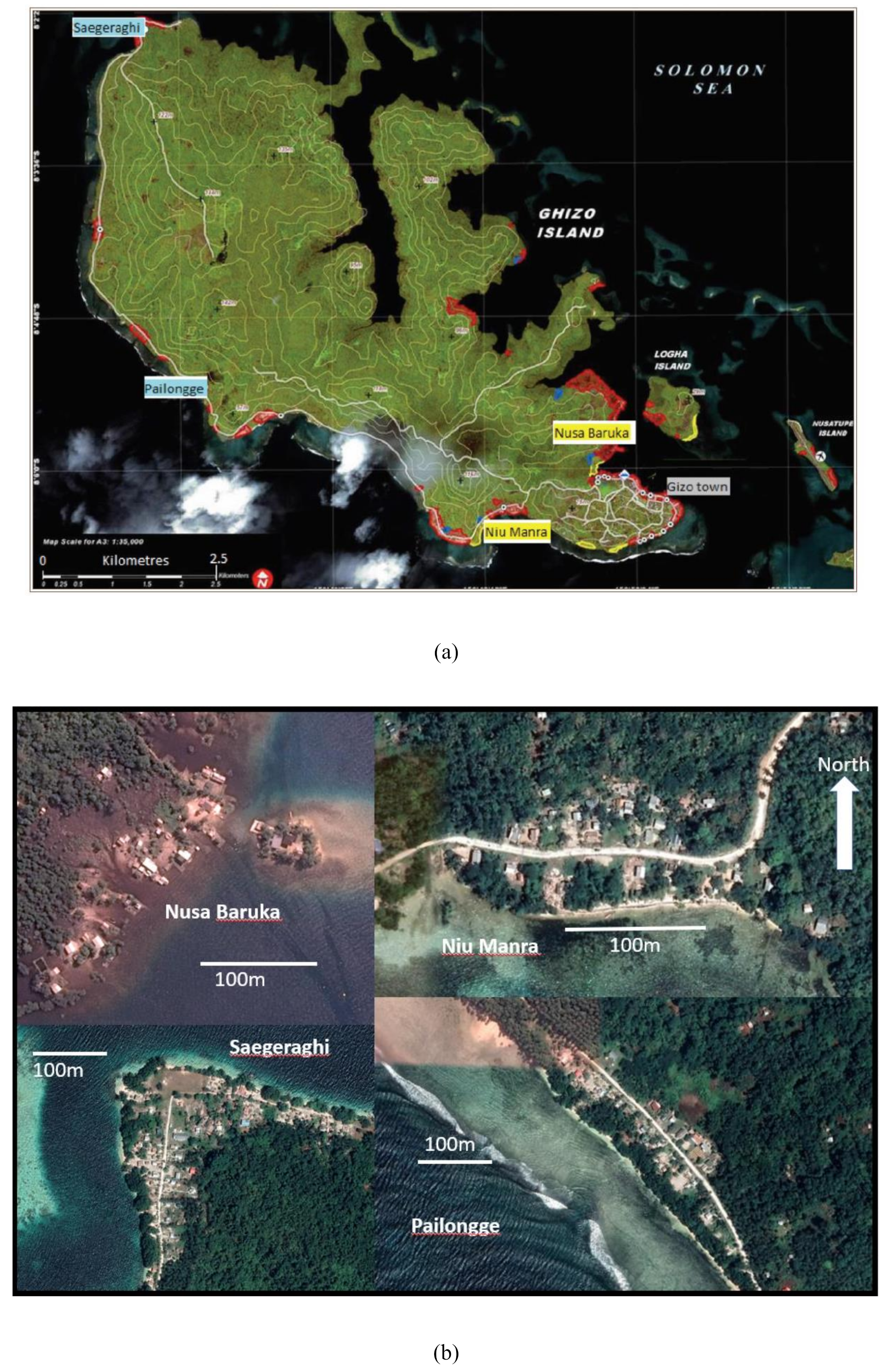
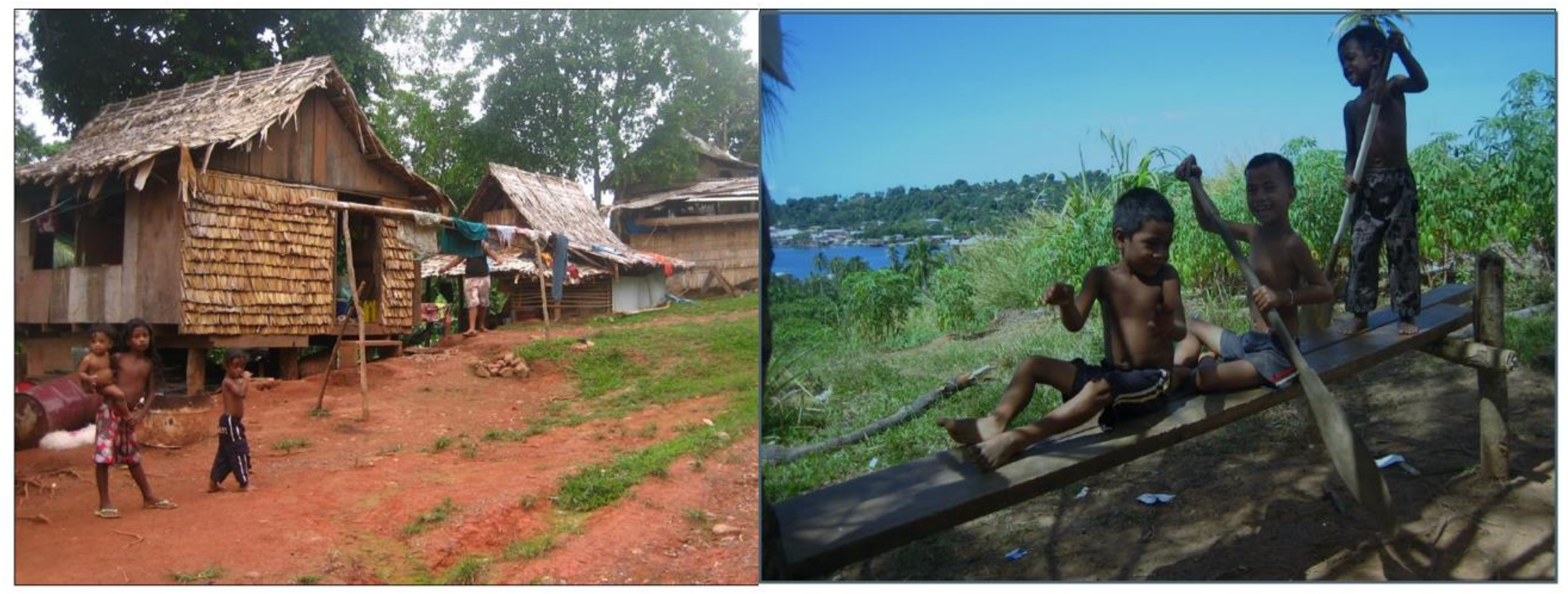
Four villages within Ghizo island were chosen for the fieldwork (Nusa Baruka, Niu Manra, Saegeraghi, and Pailongge; see
Table 3,
Figure 3,
Figure 4 and
Figure 5). These villages were chosen as a manageable representative subset of the Ghizo villages that had variably experienced the impacts of the tsunami disaster. Two of these villages are Gilbertese (Nusa Baruka and Niu Manra) and two are Melanesian (Saegeraghi and Pailongge). Furthermore, Saegeraghi is essentially comprised of one extended family, whilst Pailongge is a network of small settlements. These villages were chosen for four main reasons: (1) as examples of the two main ethnic groups on Ghizo; (2) all villages were significantly impacted by the 2007 tsunami; (3) all villages suffered coastal flooding; (4) the villages had commonalities in their location, geographical setting and surrounding topography. Pailongge and Niu Manra are situated close to higher ground and are inland from reef channels, which may have focused the tsunami energy, e.g., [
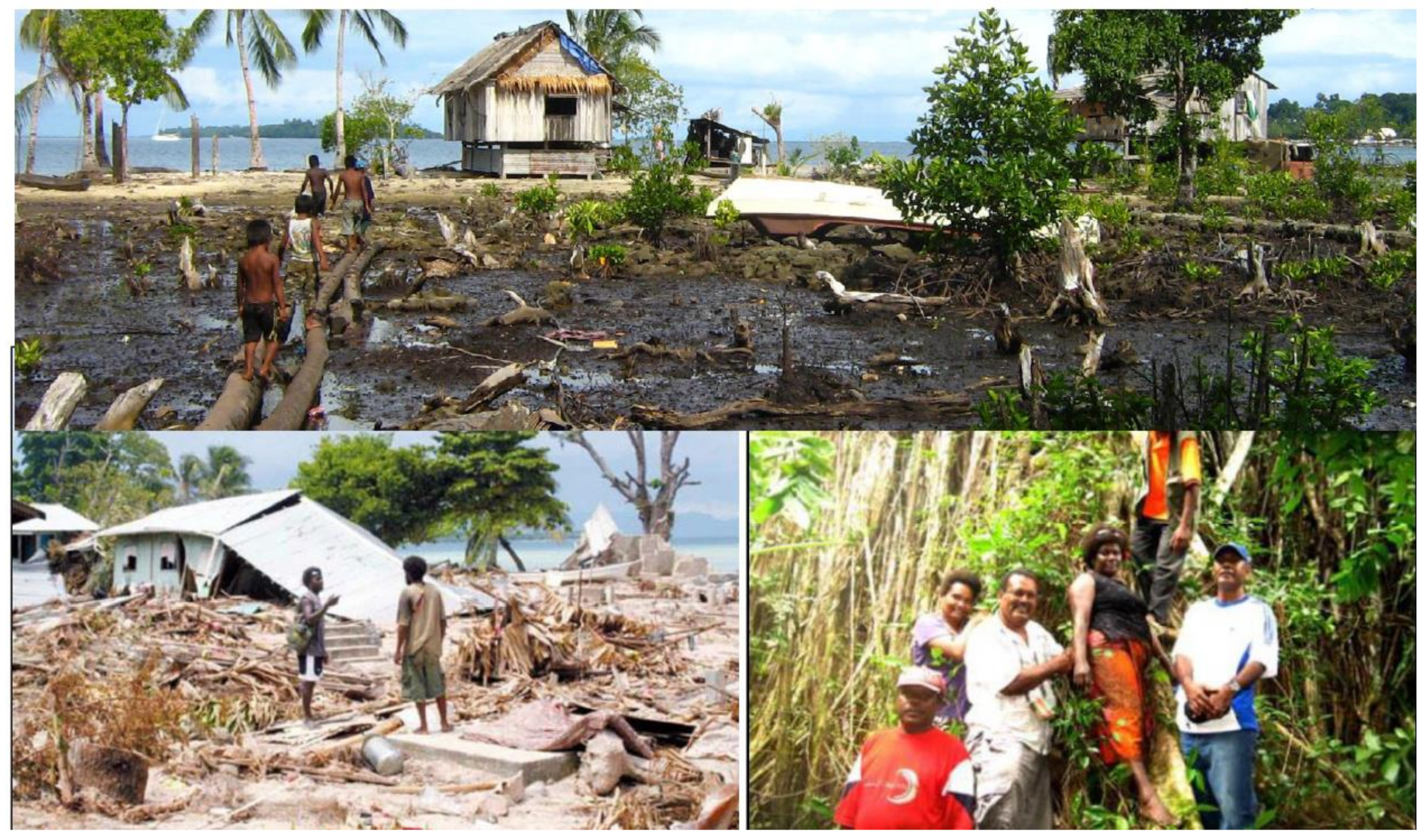
3]. Nusa Baruka and Saegeraghi had restricted road access; for example, there was no road access to Gizo town. There were no casualties in the Melanesian islands, but 10 people died (eight children aged under 10 years old) in Nusa Baruka and eight people died (five were children under 10 years old) in Niu Manra. The selection of these four villages thus enabled a rigorous and focused comparison between the experiences of the tsunami and the social responses to it by members of the two main ethnic groups being researched.
The fieldwork was undertaken over three separate field seasons. The first fieldwork visit established contact with the villagers; permission was gained from all village leaders to perform studies and work within the villages and village communities, and the visit helped frame the research questions. The following research questions were framed and methods were designed accordingly: (A) How did ethnically different communities respond to the same event?; (B) How did aid interventions influence communities’ disaster management processes?; (C) How did communities’ responses and aid interventions influence long-term recovery and resilience?
A central element of the fieldwork involved the practising of a variation on ethnographic principles [
22,
23,
24]. Ethnographic research is usually characterised by the following four features: (A) a focus on a few, small-scale cases; (B) people’s actions are studied in everyday contexts; (C) data are gathered from a range of sources; (D) the analysis of data involves the interpretation of the meaning and consequences of human actions. The research design for this project involved both indigenous and decolonisation methodologies. Indigenous methodologies advocate approaches aiming to document the realities of the research participants, stress the differences in the realities of the different socio-economic and cultural contexts of ‘researcher’ and ‘researched’, emphasise ethics, and respect local knowledge, communication and interaction [
25,
26,
27,
28]. Decolonising methodologies emphasize that research must have a purpose for both the researcher and the researched, that the research aims and methods must be understood by the research participants, and that research participants should contribute to the research design [
25,
26].
Workshops and discussions were held with communities prior to the main body of field-based research. Feedback from communities with respect to how they would like any research to be conducted included: ‘researchers must engage meaningfully over a protracted period of time, and not engage in quick and dirty research’; ‘community participants must have the work fully explained to them including their roles in the research’; and ‘the main findings and results of the research should be fully discussed and made open with the communities’.
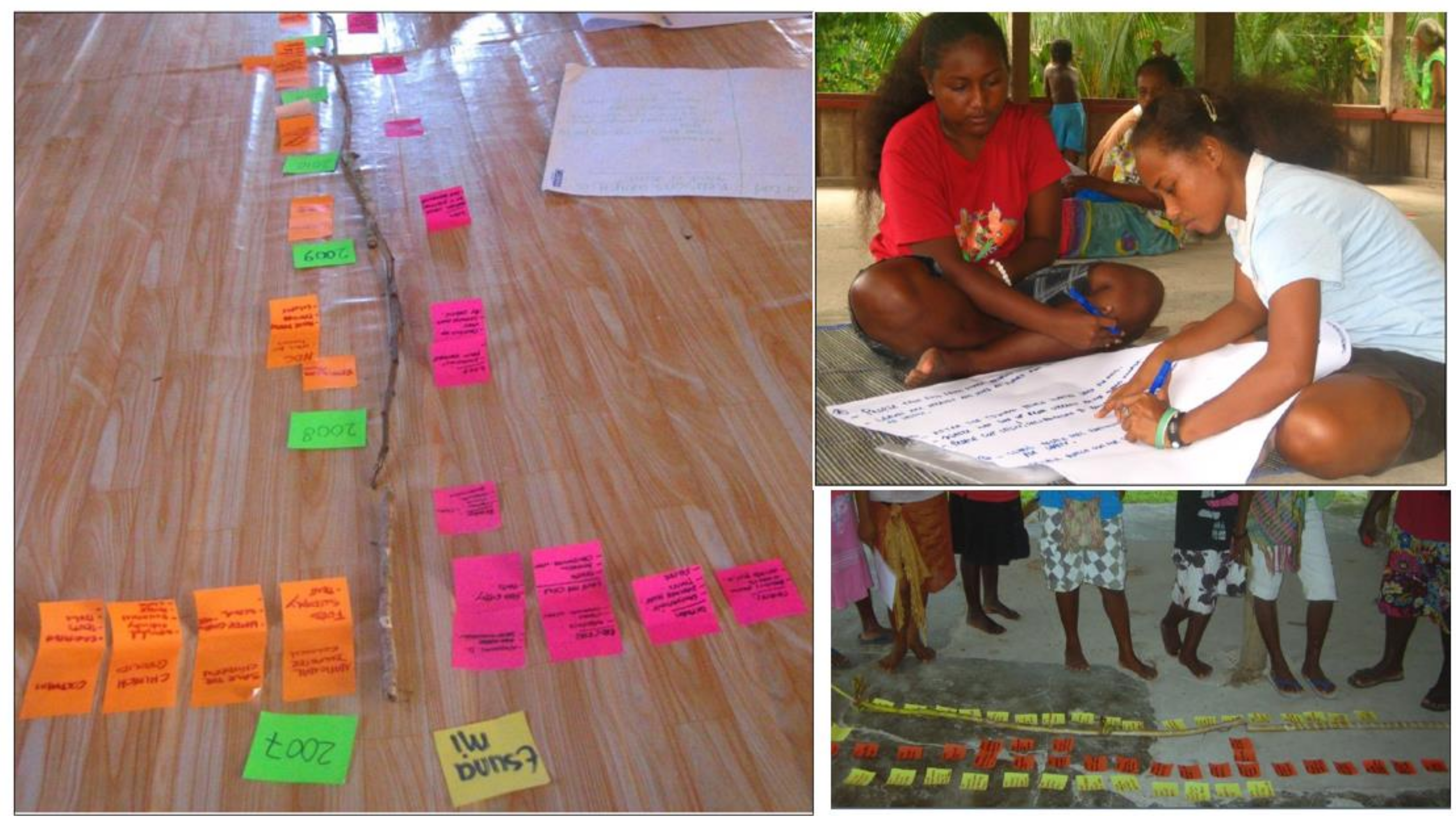
Research activities focused on: working at the village and regional scales; multiple research sites, with representative sub-components of the four villages; observations made from time spent in the capital township of Gizo; in-depth, semi-structured and more open conversational interviews; community participation; protracted village-level engagement with communities; respect; ethics; and activities that were understandable to all.
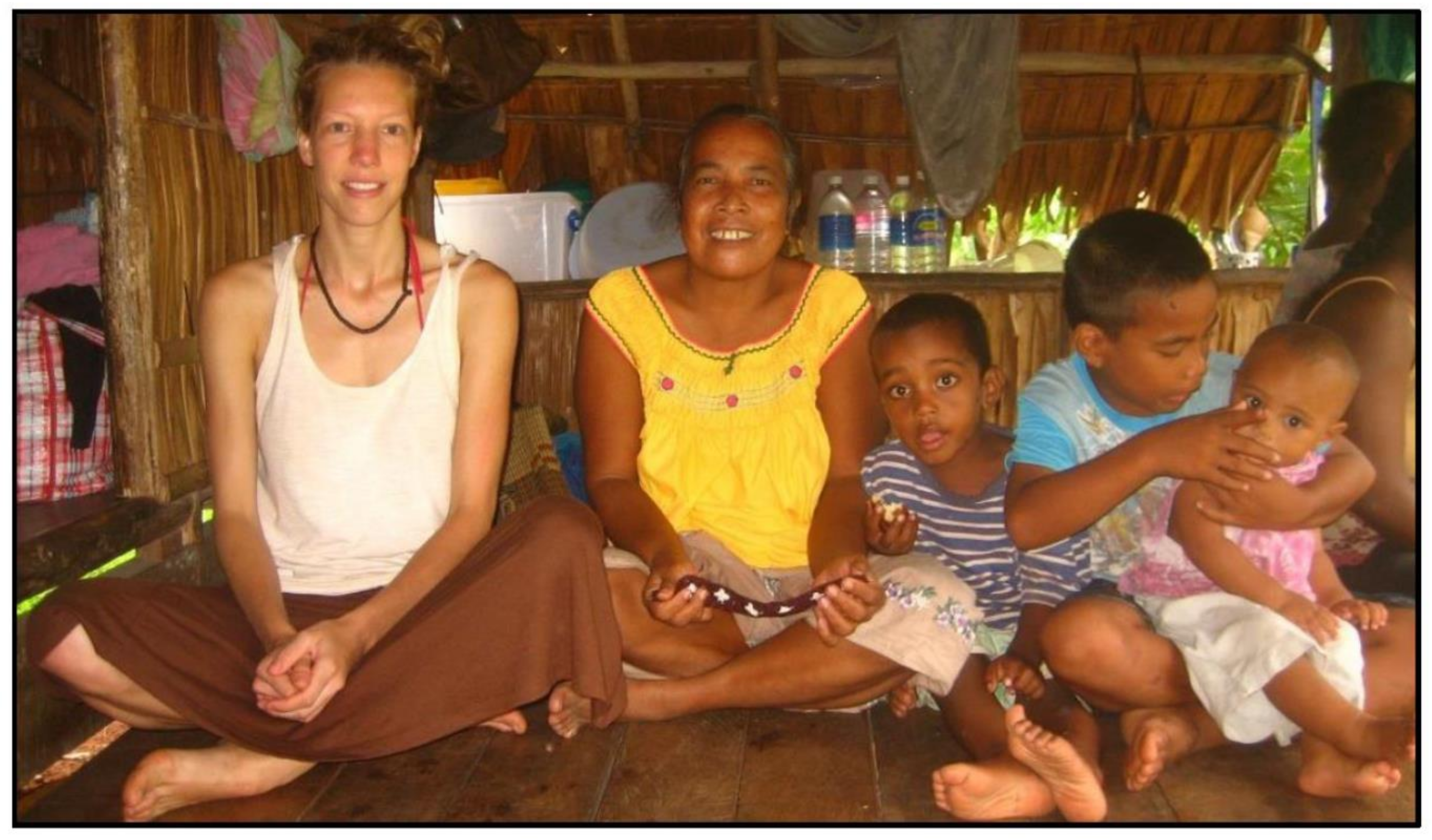
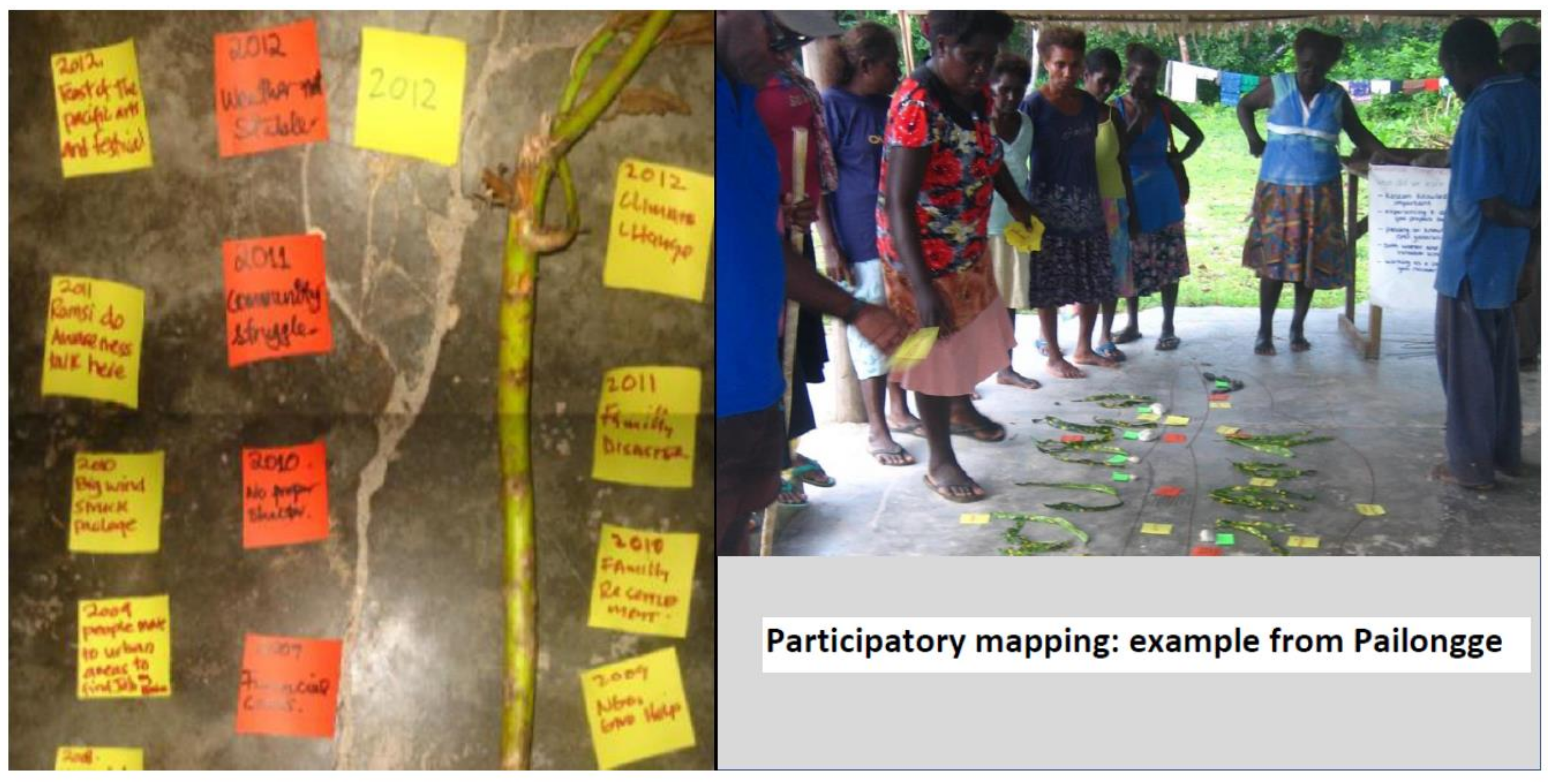
Data were gathered over a three-year timeframe. Most of the research was conducted as a participant observer within village communities (
Figure 4). All research exercises involved elements of participant observation, with the researcher observing the community dynamics by taking part in everyday community life [
29]. Participatory methods of research aim to reduce the ‘distance’ between the research participants and researcher, particularly when the researcher comes from another cultural context. Methods are characterised by the use of local products such as shells or sticks, and the absence of high-technology tools that can easily be adapted to various contextual settings, and the welcome participation of all actors of a social setting: everyone can participate in both producing and evaluating the outcomes (e.g., Chambers [
30,
31,
32]). The methods were designed to produce outcomes that are visible and tangible to all and can be carried out in and adapted to various contextual settings, involving all actors of a social setting, whether literate or illiterate, young or old, male or female, e.g., [
33,
34].
Specific methods involved: (1)
Community profiles, where participants listed the characteristics of their community along with the changes in these characteristics in the years following the earthquake and tsunami. By comparing the pre- and post-tsunami situations, data on changes that occurred were provided; (2)
Historical timelines, where participants created overviews of important past events that happened in a community or impacted on a community, as described in [
35,
36,
37]; (3)
Mapping and Ranking. Participants were asked to create maps of what their village looked like before and after the tsunami. This activity was chosen with the aim of stimulating a discussion on factors enabling and/or disabling a safe escape from the tsunami, and therefore relating to resilience issues for the 2007 events. Additionally, maps were used to discuss physical priorities for recovery [
38]; (4)
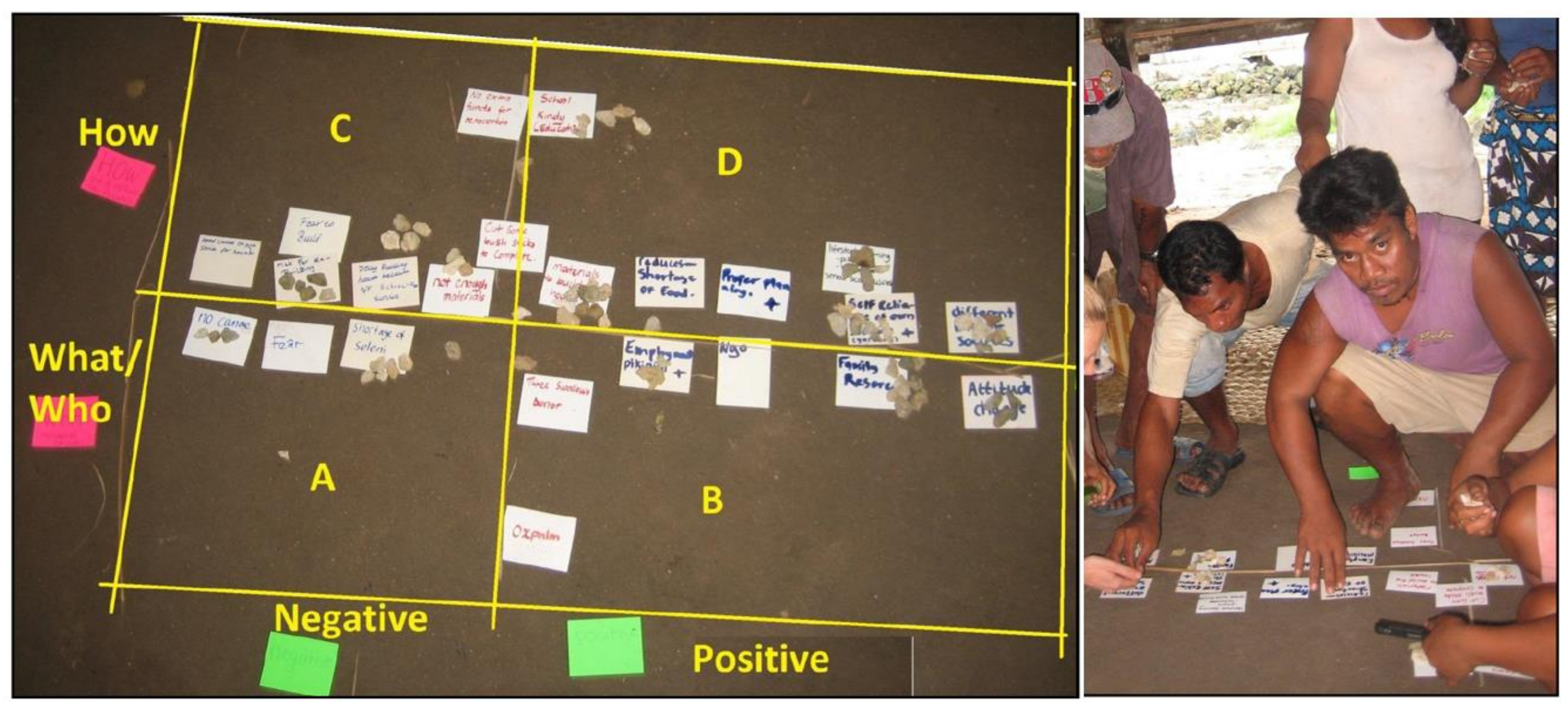
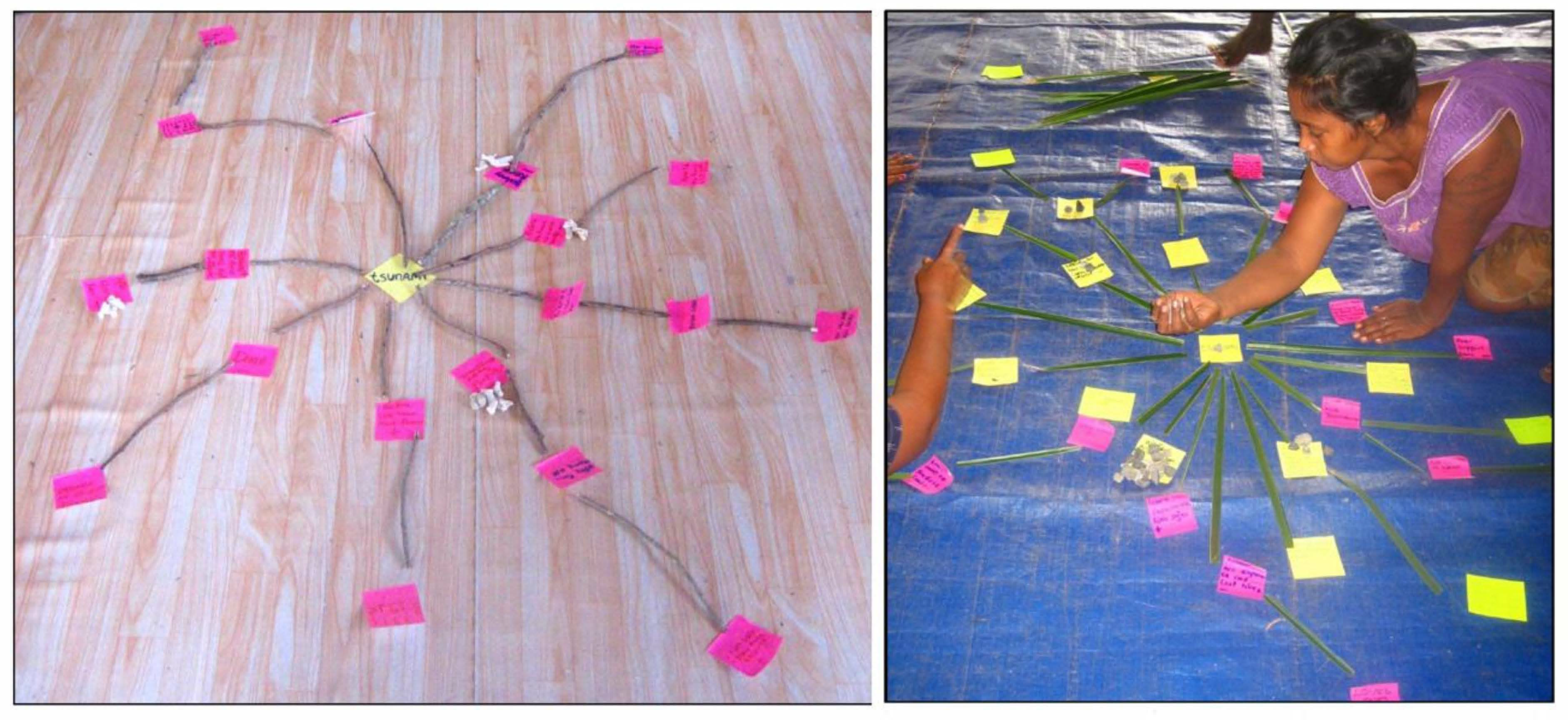
Impact diagram and pile sorting exercises provided an overview of the causal impacts of one independent variable on other variables. The impact diagrams provided insights into inter-linkages between direct and indirect disaster-effects, and reasons for post-tsunami change [
39]; (5)
Post-tsunami timelines provided an overview of important events in the years after the tsunami (2007–2012) and were created with the aim of finding out more about important events and happenings in the disaster-management processes, and if or how these events were related to possible changes in resilience; (6) Cause and effect diagrams documented community views and observations on the causes and impacts of the disaster; (7) Interviews and analysis of field documents.
5. Community Responses to the Tsunami Disaster
The initial reactions of Ghizo communities to the 2 April 2007 earthquake and tsunami have been discussed by Ride and Bretherton [
40], McAdoo et al. [
41], Fritz and Kalligeris [
7] and McAdoo et al. [
4]. Of these, McAdoo et al.’s [
41] paper ‘Indigenous knowledge and the near field population response’, looking at the 2007 Solomon Islands tsunami, provides the most detailed account of communities’ reactions to the events. The authors of the paper ascribe great importance to the role that indigenous knowledge played in saving lives during the 2007 tsunami situation. They argue that this knowledge, ‘based on generations accustomed to living on an active subduction zone’, in combination with local physiography, led Melanesian Solomon Islanders to react in a way that ‘reduced their overall mortality’ [
41]. In contrast, they state, ‘
the Gilbertese people did not hold such knowledge, which resulted in a disproportionally high death toll amongst this ethnic group, despite the beneficial physiography’. Whilst acknowledging the validity of aspects of McAdoo and colleagues’ analysis with respect to the indigenous knowledge and near-field issues, and acknowledging further extensive research in this area [
7,
27,
33,
34,
37,
38,
40,
42,
43,
44,
45,
46], we argue that this is a simplification that does not capture or fully explain the situation. We argue that a combination of knowledge types influenced the communities with respect to disaster response in 2007. These knowledge types included conditioning from Gilbertese-atoll and Melanesian-high-island environments, integrated external global knowledge and knowledge gained from disaster awareness sessions, as well as other knowledge gained from everyday living within Ghizo. Greater understanding of these contextual complexities and factors of influence can be gained by investigating survivors’ behaviour during a disaster [
47].
Our data support the use of locally relevant knowledge originating from within the Solomon Islands with respect to disaster response. Gilbertese Solomon Islanders mentioned the absence of such knowledge, as they are migrants from Kiribati. Fourteen Melanesian Solomon Islanders commented on whether they had acquired knowledge of tsunamigenic earthquakes or tsunamis prior to the 2007 events. Of these fourteen respondents, originating from various islands in the country, two men and five women mentioned they had acquired such knowledge through community or ancestral ties. Five respondents’ ancestors (either parents or grandparents) came from a neighbouring Simbo Island, and others from the eastern island of Makira. However, the data also suggest that intergenerational disaster awareness knowledge was not necessarily linked to the immediate local area (i.e., Ghizo). Rather, this specific knowledge was gained from other regions of Solomon Islands. Disaster frequency and impact influence community disaster memory, and the wider the geographic range of origin of community members, the greater the chance of community memory. Several Melanesian Solomon Islanders with relevant ancestral knowledge resided on Ghizo, especially in Pailongge and Saegeraghi. Although this knowledge was not shared extensively before the 2007 events, it was rapidly passed on when changes in the sea were observed immediately after the 2007 earthquake. Hence, Melanesian Solomon Islanders were the main beneficiaries of this knowledge. This knowledge was not possessed by the Gilbertese community pre-2007.
Table 4 summarises the research findings related to knowledge type.
A second conclusion from the community exercises was that knowledge originating beyond the Solomon Islands influenced initial reactions to the 2007 events. This knowledge, based on the Boxing Day 2004 Indian Ocean tsunami, was transferred from the global to the local levels through global media. It testifies to the mobility of knowledge in a globalised world. Two main sources of externally generated, locally relevant knowledge were identified. First, several Melanesian people said they gained knowledge by watching a commercial video on the Indian Ocean 2004 tsunami a few weeks before the 2007 tsunami. Three people claimed that the movie influenced their reactions to the unusual movements of the sea after the 2007 earthquake: they ran to higher ground when the sea withdrew and shouted to others to do the same. A second source of locally relevant knowledge originating beyond the country was mentioned in various informal conversations with people in and around Pailongge: this was the presence of two foreign surfers staying in the Melanesian village of Suvania (close to Pailongge) at the time of the tsunami. One of the surfers detailed (26 May 2012): ‘when the earthquake occurred I jumped out of window of the house we were staying at. Thinking of the 2004 tsunami I thought it would be wise to have a look at the sea. I saw the water channelling out of the reef. Never in the one month that we’d been there had I seen this happen. I started to run, and shouted at others to run to higher ground. People started to run and scream. At that time you couldn’t understand each other anymore. We could be as close as you and I are now, but we wouldn’t be able to hear each other. The people shouting and screaming, the sound of the wave coming in…’
An important factor that shaped Ghizo islanders’ reactions was the influence of local physiography/topography (
Table 5). McAdoo et al. [
41] pay particular attention to the Gilbertese village of Titiana (located between Niu Manra and Pailongge), which had the highest number of casualties of all affected villages, and the neighbouring Melanesian village of Pailongge, where there were no casualties. Pailongge and Titiana both occupy a flat plain backed by hills. These topographic similarities demonstrate the importance of indigenous knowledge: it is argued that ‘
the village with the knowledge had no casualties whilst the village without suffered casualties’. However, we argue that differences in lifestyle were equally important. The Gilbertese people mainly lived along the shoreline, spending much of their time here for their ocean-based livelihood activities. Melanesian communities are less involved with ocean-related livelihoods. Therefore, the
effective distance between higher ground and people’s locations at the time of the tsunami was significantly shorter in Pailongge compared to Titiana, which had negative consequences for the inhabitants of Titiana. In focus group studies carried out in all communities, the distance to higher ground was amongst the foremost reasons mentioned when referring to the high number of casualties amongst the Gilbertese villagers, especially in Titiana. Compared to Pailongge and Niu Manra, the higher ground in Saegeraghi was harder to reach. A large Banyan tree (
Figure 5) was the highest point that could be reached in a relatively short time span and was extensively used by villagers. One community member related the following (11 May 2012
): ‘Do you see that tree? The whole village was up there, including a woman with a three-day-old baby. We laugh about it; women wear skirts and should never climb up in something when a man is standing below, but in this case we ignored the rule’. Higher ground was also difficult to reach in Nusa Baruka. At the time the tsunami hit, the majority of houses were built by the seaside, on the reef. The houses were built on stilts in the water and people traversed between them by canoe. This impeded a quick escape; as the village was partly built in the sea and between mangroves, people struggled to reach higher ground. Both Nusa Baruka and Niu Manra had a stand of mangroves within the coastal zone. Mangrove stands can, in certain situations, offer a protective defence against incoming tsunami waves [
41,
48]. In Niu Manra, the tsunami energy was strong enough to overwhelm this potential buffer [
41]. Hence, Niu Manra’s affected villagers had no positive opinion on the protective function of mangroves. Several people described how they or their children got stuck in the mangroves as they were being swept away by the tsunami waves. One account states (16 March 2013): ‘
I struggled [to swim], I passed the mangroves, those mangroves at the seaside. I passed the mangroves and got stuck there. I saw one woman, she was crying: ‘Help me, help me!’ Her two children were stuck in the house in the mangroves, both small children. So we struggled to take the children out. A minister [from the church] eventually got the children out’.
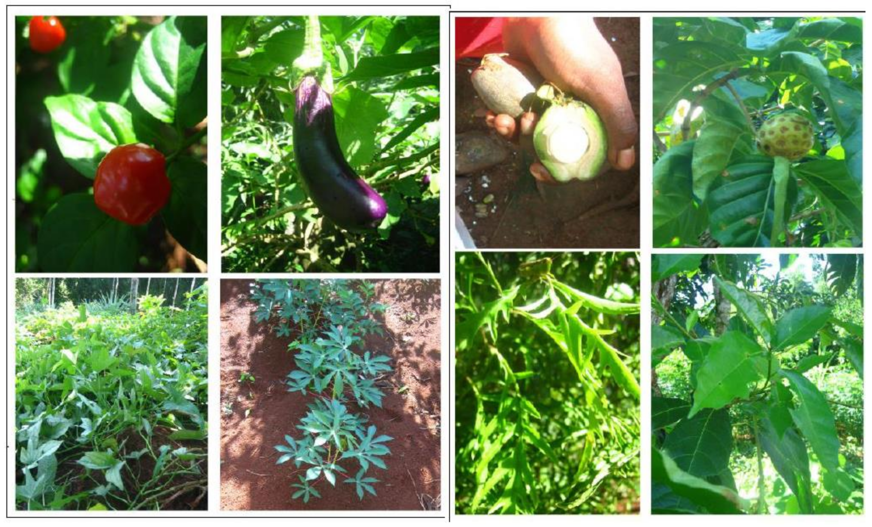
Table 5 summarises the main factors that shaped the immediate community responses to the 2007 tsunami. Most Melanesian villages have well-constructed footpaths from their village to the agricultural gardens that they tend (
Figure 6 and
Figure 7). This is important for tsunami mitigation, as it may provide evacuation access to higher ground with respect to a low-lying coastal village. Pailongge’s participatory mapping activity indicated that the gardens and ‘viewpoints’ on higher ground were untouched by the tsunami waves, whereas most of the village itself was inundated by the tsunami. By discussing the tsunami run-up on Pailongge’s map, participants explained that the footpaths connecting the villages to the higher ground were used for a fast evacuate when the tsunami waves approached. These paths were not designed as evacuation paths and they were not separate rescue systems, but they served an evacuation purpose during the disaster. At the time of the tsunami, the Gilbertese population’s livelihood activities were predominantly related to fishing and harvesting seafood. Some people in Niu Manra did have ‘
babai’ (swamp taro) gardens in the area behind their houses, but these were not situated on higher ground. The absence of paths that could be used for evacuation is a major difference between the pre-tsunami map of Pailongge and those made in Niu Manra and Nusa Baruka. In Niu Manra, it was stated that, prior to the tsunami, there were no paths leading uphill from their village. In Nusa Baruka, there was one path leading inland.
6. Community Responses to the Period Immediately Following the 2007 Tsunami Disaster
There was a distinct difference in behaviours between the Melanesian and Gilbertese communities. After the tsunami waves hit Ghizo, most survivors sought refuge on higher ground, afraid to return to the locations of their former coastal villages. On higher ground, they waited for disaster aid to arrive (3–4 days). During those 3–4 days, affected villagers had to rely on their own survival strategies to deal with the immediate post-disaster situation. Coping mechanisms during this period were influenced by two factors: disaster subculture, and livelihoods.
A disaster subculture refers to patterns that are operative in a specific area, geared towards the solution of problems arising from the awareness of disaster threats or from having experienced previous disasters [
49]. This knowledge is mainly passed on orally and intergenerationally. It is embedded in historical and geographical contexts, and is expressed in cultural facets such as legends, knowledge, and practices [
37,
43,
46,
50]. One key example for the Melanesian experience is a sub-culture that developed around drought periods. Our research revealed that, during times of drought, Melanesian communities learned to change their agricultural practices, and focus more on drought-resistant crops such as cassava and banana, as well as diversifying water supply options. This same sub-cultural experience failed to influence Gilbertese communities, as they relied less on agriculture, and more on ocean-harvesting. Food security was not affected for them during times of drought and traditional water supplies were sufficient. Wenger [
51] lists three factors that determine the development of a disaster subculture: (A) the repetitive nature of an impact, (B) the time gap between signs of the disaster and the impact of the disaster, and (C) the level of damage or impact.
Livelihoods play an important role in the capacity to cope with disaster. The diversification of livelihoods is important for reducing the risk of a hazard turning into a disaster or a disaster escalating even further. If a livelihood consists of only one activity and that activity becomes inaccessible, coping mechanisms can become difficult [
50]. Livelihood diversification influences the disaster-coping capacity [
50,
52,
53,
54]. The strength of livelihoods can be measured by the presence of livelihoods outside of vulnerable areas [
52] or their transferability to other locations [
55]. Participatory mapping exercise and interview results clearly demonstrate the higher pre-disaster resilience state of Melanesian communities when compared with the Gilbertese communities. The greater livelihood diversity and strength of Melanesian communities (manifested as widespread cultivated gardens, a wide range of crops, knowledge of foraging within the bush and bush materials, a more diverse animal husbandry and bush-hunting capabilities), coupled with their relative elevated confidence in land tenureship (Melanesians had a strong historical case for land rights and tenureship and resented ‘incomers’ claiming land rights) and immediate links to other wantoks through established mutual kastom, were all in their favour. Melanesian gardens were unaffected by the tsunami. Melanesians lost cooking utensils, pots and pans, but these were communally shared amongst wantok groups as a demonstration of kastom. The social capital that kastom brought, alongside the unquestioning land tenureship rights of Melanesians, added to their confidence. Melanesians also were able to practice traditional cooking within the earth (motu cooking), whereby hot stones are placed within an earthen pit that forms the heat for traditional motu cooking. Motu cooking is aligned with bo-ne bo-ne cooking, with foods cooked directly in a fire with and the burnt parts later unravelled to reveal the cooked inner food parts. Collectively, the Melanesians had a strong sustainable system that allowed them to cope well in the immediate post-disaster phase.
Gilbertese mostly experienced the opposite of the coping situations described for the Melanesians. They are reliant on ocean resources, which were denied to them in post-tsunami times because of the trauma of the tsunami disaster, and the fear of being close to the sea. The Gilbertese had no hinterland gardens, no knowledge of foraging for wild food, and no knowledge of
motu or
bo-ne bo-ne cooking. Furthermore, they had limited secure land tenure beyond their coastal settlements: the majority of the host Melanesian community’s feelings regarding the granting of land to migrant Gilbertese communities are mixed at best. Whilst the Gilbertese communities survived during the immediate post-tsunami period, their coping mechanisms were less resilient, with survival being more of a struggle for them (
Table 6).
7. Community Perceptions of Aid Intervention and Longer-Term Aid Impacts
Results from interviews and conversations with representatives from the four villages and Gizo town elicited a remarkable degree of similarity (with local differences) with respect to community perceptions of the impact of aid in the shorter and longer term. The early days of intervention were generally universally applauded. The early post-tsunami period had a primary focus on essential needs such as food, water, sanitation, clothing, and shelter. Oxfam and the Solomon Islands Red Cross non-governmental organisations (NGOs) were particularly praised for this phase of operations. The results are shown in
Table 7 below. Images of participatory work for this and previous sections are shown in
Figure 8,
Figure 9 and
Figure 10.
Dissatisfaction began with the phase two longer-term recovery operations. The first criticism revolved around NGOs asking survivors about their post-disaster needs. Communities stated that this was disorganized, with too many players, too many surveys, a perceived lack of communication and collaboration between key aid organisations, duplication of efforts, and inadequate feedback to villagers with respect to surveys. Several people mentioned that the surveys had the unintended consequence of raising expectations amongst impacted communities. The government appointed fewer actors as aid coordinators. Oxfam were assigned a primary coordination role as a key aid coordinator. Oxfam had proven themselves to the government (at the time) as a reliable and credible operator for aid coordination. Oxfam operated two post-disaster intervention phases: (1) a review of needs analysis data and continuation of basic needs provision (May–August 2007); and (2) delivery of longer-term aid with the objective of moving communities into a sustainable, more permanent post-disaster status (primarily between September 2007 to 2010). It was this phase that attracted the most criticism.
The negative impacts of the aid delivery were perceived as: (1) Aid managers making decisions relating to ‘helpers’ that influenced aid outcomes, with some (largely expatriate) aid personnel remaining too long ‘in their offices, and not in the field’; (2) Perceived ethnic discrimination between the Gilbertese and Melanesian communities that led to inequitable aid distribution; (3) Power hierarchies playing out within the wantok system leading to inequitable aid outcomes; (4) All four villages noted that disharmony and division increased as a result of disputes concerning aid distribution.
One driving philosophy of the aid intervention programmes in Solomon Islands was to use the activities as an opportunity for employment. Solomon Islanders were employed to assess and distribute aid. These Solomon Islanders did not necessarily come from Ghizo, and brought their own worldview to Ghizo. Some employees seemingly had sympathies and allegiances with some of the wantok tribal groups on Ghizo. The Gilbertese ethnic group was mostly absent from aid provision activities. Expatriate workers tended to undertake managerial and coordination roles and were observed in the village to a lesser degree than Solomon Islander staff. There was a perception amongst the interviewed aid recipients that expatriates not working directly with the affected communities, but employing Solomon Islanders to do so, led to favouritism and bias in aid delivery, and disharmony amongst communities
Within all groups, the power hierarchical structure impacted aid intervention outcomes. Elders in the Gilbertese communities and Bigmen in the Melanesian communities, alongside their close family and allies, were perceived to engineer preferential outcomes in terms of quality and quantity of aid supplied relative to the less powerful or marginalised groups within the same communities. The kastom tradition of sharing and community first principles broke down to some extent, with individualism coming to the fore. The impact of these behaviours on a sharing communal culture, such as is present in Solomon Islands, is of high significance, with jealousies and resentments driving disharmony and division amongst communities. Hierarchies that had previously been respected could now be viewed with an element of cynicism. This feeling was magnified between ethnic groups. The Gilbertese community perceive discrimination in general, in the form of lesser access to national goods and services, alongside diminished political influence, and saw both inter-ethnic discrimination and intra-community power hierarchies play out during the period of aid interventions. This situation increased disaffections within their communities to a greater degree than within Melanesian communities.
All villages noted lasting disharmony and division following the later aid intervention stages. In Niu Manra, the community physically split into a community close to the sea and one on higher ground. This physical split accentuated disharmony. Nusa Baruka was split into five separate communities. The Pailongge communities were perceived to ‘scatter’ and not ‘pull together’, whilst Saegeraghi split into lower and higher ground communities. The perceived inequalities with respect to aid outcomes led to communication issues, with some groups barely talking or not talking to other groups. The physical separation did not help, as this encouraged silo-thinking and negative perceptions of one another. Some villagers had a variety of church and religious affiliations. Within the Gilbertese communities, some of the Elders died, with few younger people stepping forward to attract communal support; maneaba processes were diminished, and there was a sense of loss of community cohesion and an increase in community social issues, such as heavier consumption of alcohol. Tensions between the Gilbertese and Melanesian communities were exacerbated. Within the Melanesian communities, these issues also manifested, although to a lesser degree. In Pailongge there was a common church, which was viewed as a positive factor in pulling the community back together. Both Pailongge and Saegeraghi had strong family links, which were strained, and whilst parts of the communities came back together, albeit perhaps with a different equilibrium, disharmony remained for parts of the community, compared to pre-tsunami times.
The Solomon Islands National Disaster Management Office (SI-NDMO) were interviewed regarding the key results of this research. They were aware of the kastom- and power-play-related issues, as well as perceived disharmonies between ethnic groups. The SI-NDMO regularly respond to disasters and have accrued a large knowledge base. Their position is that it is difficult for the SI-NDMO and aid providers to address these issues diplomatically. These experiences are emotionally charged, and many disaster victims suffer from trauma. SI-NDMO argue that many communities expect too much, and can become less self-reliant once external interventions arrive, viewing the provision of goods that are ordinarily beyond their economic reach as opportunities to access as much as possible within a time of relative riches. Some community members deliberately destroyed their traditional houses, claiming that this was the result of tsunami impact, in order to claim metal roofs and construction materials. SI-NDMO followed up aid interventions with a gap analysis of aid recipients and accessed additional funds to provide to those who may have lost out on materials in the first round.
8. Discussion and Lessons Learned
This research highlights a number of key issues that can inform a deeper understanding of how situational social-economic contexts prior to disaster can shape disaster impacts. Additionally, data related to the impacts of aid interventions provide policy suggestions for future aid interventions. Recommendations are listed in
Table 8.
For the case of Ghizo, the pre-disaster situation was characterised by several key existential social and behavioural phenomena, which either supported community capacity and resilience or enhanced vulnerabilities with respect to disasters. The Gilbertese communities, although resident in Ghizo for over 30–50 years prior to the 2007 tsunami, had not assimilated Melanesian behaviours, which could have improved post-disaster outcomes. Gilbertese livelihoods were limited and strongly ocean-linked, knowledge of the hinterland and hinterland agriculture/wild bush resources was low to non-existent, cooking methods were limited, there was a limited knowledge of the early warning signs of a tsunami and how they are linked to earthquakes, and there were perceived inter-ethnic discrimination issues that impeded community connectivity and learnings that could have led to government oversight.
There are essential learning points to be raised from this analysis. First, immigrant communities are likely to have greater levels of vulnerability compared to the majority population, particularly if they perceive themselves to be, or actually are, discriminated against and marginalised [
17]. We argue that disaster-awareness and educational activities should be proactively directed at such communities.
These activities should include events where all community groups are brought together to learn from one another. Whilst this is difficult for some communities, particularly where there are embedded and/or historical inter-community tensions, the difficulties should not be viewed as impossibilities. This approach should inform all government policies that have a bearing on disasters (e.g., land planning, housing, utilities, infrastructure and social welfare). Second, previous research indicates that livelihood diversity is one of the elements of a disaster-resilient community [
52]. The evidence presented in this paper supports this argument. Disaster policy should, where possible, encourage communities to consider livelihood diversification, although it is recognised that this is not always possible. Third, whilst MacAdoo et al. [
3,
4,
41] argue that indigenous knowledge is key to disaster response, we argue that indigenous knowledge alone, whilst highly valuable, can be limited in the perceived protection it affords. Communities are dynamic and it cannot be assumed that traditional wisdom is universally passed down generations. Knowledge is increasingly externalised and globalised, being delivered in many forms across different media. This research highlights that appropriately designed disaster awareness campaigns, coupled with the development of self-sufficient, sustainable, intra-community disaster education capacity development, are a more effective way of building community resilience
. A Pacific example of this is in relation to cyclones, with governments and communities communicating much more effectively than thye did historically with respect to community protection [
56,
57]. Fourth, whilst not within the scope of this study, one element that stands out is land spatial planning policy. All communities impacted by the 2007 tsunami were coastal communities, made vulnerable by their proximity to the ocean. It is impossible and even unwise to move all coastal communities to hinterland, more protected positions. However, disaster policies should be developed with a clear focus on coast vulnerability and the mitigation of vulnerability, for example through raising awareness of the importance of evacuation routes and increasing awareness of disaster early warning signals.
The immediate
post-disaster situation, three to four days following the tsunami, highlights another set of key points, mostly connected to the discussions above. Melanesian communities were the most resilient in this situation because of their agricultural, foraging and hunting skills within the bush, together with their cooking techniques, which were well suited to this situation. Alongside these factors are the enhanced social capital,
wantok reciprocity culture, and close ethnic connectivity with other less impacted Melanesian communities. Finally, an important point is the land-tenure confidence of Melanesians. The migrant Gilbertese community, whilst surviving this period, struggled significantly more than the Melanesian community, largely through the absence of the above advantages. These issues highlight the vulnerability of migrant and marginalised communities, particularly in situations of
a lack of inter-ethnic mixing and shared learning. The relative fragilities identified here are not only a concern of disaster management authorities but go to the roots of social cohesion. We recommend that local government, backed by national government, develop policies to address any lack of social cohesion or communal learning within their jurisdictions. Furthermore, we recommend that disaster policy takes particular note of the potentially enhanced vulnerabilities of migrant communities. Specific efforts should be made to reach out to these communities and at least fill gaps of relevance to disasters. One specific area is more secure and more widely recognised land access, rights and tenure (
Figure 11). The lack of communal agreement in this area adversely affected the Gilbertese community in the immediate post-disaster situation, as well as over the longer term. A lack of resolution over land rights mitigates long-term solutions and leads to inter-communal resentment. We recommend that migrant communities are offered an agreed permanent place of refuge, with secure land rights that cannot be contested by other communities, and in which previously marginalised communities feel safe and can build long-term solutions to disaster adaptation.
Research outcomes with regard to the
longer-term aid intervention situation largely revolve around power hierarchies, inequitable aid supply distribution, and a loss of social self-help, cohesion and harmony. These are not new lessons. Universally, aid can become a political tool at many levels [Bibek, 2017]. The SI-NDMO was aware of most of the issues that relate to inequitable aid outcomes, in spite of the principle of aid-equity being foremost in the mindset of most professional disaster actors. One area that was highlighted was the appointment of Solomon Islander aid workers, who were perceived as ‘biased’. One obvious way to alleviate this issue is to only send outsiders to the disaster, but this too can be fraught with issues, and outsiders themselves can be criticised as lacking local knowledge and understanding, or accused of favouritism. In job-deprived countries such as Solomon Islands, the need to offer employment may outweigh issues relating to aid distribution. Aid distribution in post-disaster situations is inherently challenging, as it involves vulnerable traumatised victims, a sense of high expectation (at least initially), and various degrees of human desperation. Aid providers must (and mostly do) operate on equitable principles, with a view towards longer-term social harmony as well as the immediate situation. We suggest that aid coordination is particularly vital and must be addressed as such, making coordination as simple, clear, equitable and transparent as possible. In addition, aid organisations could develop policies and employ appropriately trained personnel to examine the potential impacts of aid decisions on long-term social harmony. A mindful long-term consciousness approach that feeds into policy, principles, actions, and staff recruitment could be a way forward. Government has a strong role to play in the longer-term recovery of impacted communities, post-disaster. One lesson here is that the post-disaster social equilibrium is different to the pre-disaster situation. Community disaster resilience itself may improve as a result of the disaster experience within communities. However, there is likely to be community change resulting from the disaster [
46,
52]. In the case of Ghizo, this has led to positive outcomes such as increased awareness, livelihood and behavioural diversity, and less positive outcomes that include increased community tensions. Government can assist in providing activities such as trauma care, relationship (community and individual) counselling, and opportunities for inter-communal mixing. These activities do not have to be expensive and must be community-appropriate, with the communities themselves as the main actors [
58,
59].
8.1. Regional and Global Dimensions
The previous section synthesises documented lessons learned for a Solomon Islands situation. Which lessons are applicable to wider regional and global scenarios? How can wider lessons from global experiences be combined with the lessons of this case study? Some important issues have been noted in previous discussions in this context, (e.g., cyclone experiences in other Pacific countries and the politics of aid). Some learning lessons may have particular relevance for tsunami disasters, as these largely impact coastal zones, and areas of lower topography close to coastal zones, whilst other disasters can be more widespread in their impacts (e.g., floods, cyclones). One example that fits this category are lessons regarding evacuation routes. The communities on Ghizo who frequently used paths to the higher interior
and knew that moving to higher ground reduced risk reduced their exposure to tsunami risk. These types of lessons are embedded within numerous regional and national disaster awareness and preparedness programmes. An example is the Disaster and Community Resilience Programme of the SPC [
60], which has delivered hundreds of workshops and invested in local capacity building in this area in 16 Pacific Island Countries. One tangible result is the building of signage posts in many Pacific countries (e.g., Fiji, Cook Islands, Vanuatu), directing people to higher ground with a clear link to tsunami hazards. This signage is coupled with education and awareness programmes on all aspects of tsunamis including what signs to look out for (e.g., felt earthquakes, coastal and reef zones unusually drying up) and how to respond. A greater usage of tsunami warning systems such as the Pacific tsunami warning system [
61] is apparent across the Pacific region, and globally, following the Great Indian Ocean Tsunami of Boxing Day 2004. Messages from the early warning systems are now regularly incorporated into media across the Pacific Island states. Whilst these programmes are effective, they have limited reach, and will never reach all communities. Levels of lower or variable awareness will exist, particularly in remote communities, as this study reveals, and this situation should be addressed through the building of capacity at village, local and regional levels.
The issue of an understanding of heterogeneous communities and ‘sub-cultures’ with respect to all aspects of Disaster Risk Reduction (DRR) Governance is perhaps the most fundamental lesson learned from this research. This has universal application and is increasingly better understood [
7,
8,
10,
13,
17,
19,
22,
32,
33,
38,
49,
50,
51]. It can be argued that almost all communities have elements of heterogeneity and subcultures (e.g., age, gender, disability, sexual orientation, political and/or tribal affiliation, language/dialect, region, and so on). An increasing awareness of this issue and its significance with respect to DRR has gradually increased the effectiveness of DRR governance. Take messaging and awareness of disasters as examples: the past few decades have seen a change from ‘messaging for all’ and ‘one approach for all’ to the development of different approaches for different communities/sub-cultures, taking particular note of the more acute vulnerabilities present within discrete parts of the community (e.g., people with disabilities, elderly, youth, [
60] and livelihoods that increase exposure to risk, such as rice farming and lightning risks in Odisha, India [
62]). More marginalised communities in many countries suffered disproportionately from increased mortality to the COVID-19 virus, and it can be more challenging to convince vulnerable communities to take advantage of vaccination opportunities [
63]. This research strongly underlines the need for diverse approaches to DRR for diverse communities. We argue that a longer-term, nuanced educational and awareness approach with respect to Ghizo Gilbertese communities would have saved lives and reduced post-disaster impacts. This finding has been replicated across the globe in a wide range of settings and scenarios.
The importance of access to safe land, land spatial planning, and land tenureship as a means of reducing risk is an equally fundamental finding of this research. Tellman et al., 2021 [
64], clearly demonstrate the increased global risk of flooding due to a range of factors, one being migration, another poverty/marginilisation, and another being a lack of connection between settlement and Disaster Risk awareness. This study reveals that, increasingly, particularly in some lower–medium income countries in South and Southeast Asia, and Sub-Saharan Africa, but also in higher income countries, such as parts of Europe, people are settling within areas that are subject to flooding. Poverty and marginalisation reduce choice with respect to settlement: the most socially vulnerable can be situated in areas with the highest environmental risk. A Pacific Island example of this situation is illustrated by Reuben and Lowry. 2016 [
65], who spatially analysed risk with respect to flooding for the extreme weather event in 2016, Honiara, Solomon Islands. In this case, the capital city was inundated by the flooding of the Mataniko River. In this case, flooding disproportionately affected the relatively poor and marginalised communities of Burns Creek: an area within Honiara known to have a higher risk level for floods. Customary land ownership within Pacific islands is a strongly embedded tradition, and strongly influences settlement, reducing settlement choice for migrants into one particular area. The issue of changing land laws (the iTaukei Land Law Reforms of 2021) within Fiji illustrates the extreme sensitivity of land ownership within Pacific Island Countries [
66]. This study clearly shows that the Gilbertese communities (as with the Burns Creek communities in Honiara) were placed in a situation of elevated exposure to tsunami (flood) risks due to a lack of land-planning foresight that did not include consideration of settlement and tsunami risk,
and the issue of Indigenous land ownership, reducing opportunities for the Gilbertese to settle within environmentally safer locations. Whilst customary land ownership may only affect some parts of the world, the issue of limited choice of settlement location for the less affluent and more marginalised, coupled with increasing environmental risks through, for example, climate change impacts [
64], is one that many countries and regions will increasingly have to manage. This research underlines the potential consequences if these lessons fail to lead to evidence-based and effective policy and action in this regard.
8.2. Solomon Islands and Regional Pacific Disaster Risk Reduction (DRR) Activities
The recommendations for improvements to DRR approaches made in this paper can only have a real-world impact if they connect with the DRR architecture of Solomon Islands and the Pacific region. The Pacific Islands region has a number of regional organisations with DRR responsibilities, such as the Pacific Community (SPC), the South Pacific Regional Environmental Programme (SPREP), the Pacific Islands Forum Secretariat (PIFS), and the University of the South Pacific (USP). A number of UN organisations are present at regional and national levels, including UN Office for Humanitarian Affairs (UNOCHA) and UN International Strategy for Disaster and Risk Reduction (UNISDR). SPC operates the largest programmes, undertaking a range of interventions including technical–scientific analyses, community awareness workshops, capacity-building, largely at the government level, and policy development. SPREP focuses on the ecological and community aspects of DRR, and PIFS works at a more political level, with Pacific Leaders and leadership teams developing both national and regional approaches to climate change and DRR. USP undertakes academic research in specific areas of DRR. UN agencies work independently of regional organisations, although they work within a collaborative framework, and link to the global UN network. A number of NGO organisations are active in the DRR space including Red Cross, Oxfam, World Vision, and Save the Children. Aid donors work largely through regional and national governments, as well as NGOs, and include the aid agencies of the European Union, Australia, New Zealand, France, UK, USA, Japan, and the World Bank. Pacific Island countries have their own National (and Regional) Disaster Management Offices (NDMOs). These are bureaucracies within their own government structures that liaise closely with the regional organisations noted above. There is a solid, working connectivity across national and regional disaster management offices. Ghizo falls within the Western province of Solomon Islands and has a Regional Management Disaster Office that links with the national office based in Honiara. One example of how this regional and national architecture for DRR plays out in specific countries and regions was published by the Government of Solomon Islands [
67,
68]. This document sets out a template for a holistic and inclusive approach to DRR within Solomon Islands, including Ghizo and the Western Province. The report notes the lessons learned from the 2007 Ghizo tsunami, stating that ‘
the April 2007 earthquake and tsunami impacted both Western and Choiseul provinces. Fifty-two people died, and 6,000 buildings (including homes, schools and hospitals) were damaged or destroyed. The cost of reconstruction from that disaster was estimated at around US$100 million or 80% of the national recurrent budget’. The report advocates for better practice in DRR for the Solomon Islands, learning from past lessons, and progressing towards approaches that incorporate: a ‘more joined-up and smarter use of data’; ‘the supporting of self-help and local dependency at community levels;’, ‘community ownership of and participation in DRR approaches being of highest level importance;’ ‘timely interventions and data gathering’; and, ‘a multi-agency approach’. Whilst these principles are on a higher level compared to many of the policy recommendations made in this paper, it is heartening to see that the higher-level goals interconnect with the recommendations here, such as the reconfirmed recognition of capacity development and issue ownership at local community levels, and a culture of data openness and sharing. Issues such as land ownership and the relative power hierarchies of landowners and non-landowners remain controversial and difficult, with no ultimate resolution in sight at the time of writing.


