

Climate Change Migration and the Economic Rebirth of Central Appalachia
Department of Business Administration and Economics, University of Virginia-Wise, Wise, VA 24293, USA
Soc. Sci. 2022, 11(10), 462; https://doi.org/10.3390/socsci11100462
Submission received: 12 July 2022
/
Revised: 15 September 2022
/
Accepted: 15 September 2022
/
Published: 10 October 2022
(This article belongs to the Topic Energy Management and Sustainable Development from Economic, Social and Environmental Aspects)
Abstract
:This research examines the potential economic rebirth of the Central Appalachian Region as persons from the southwestern and southeastern parts of the United States seek a safe and livable environment for their families and businesses. Central Appalachia is projected to be the largest habitable area in the continental United States by the year 2050. However, mined land remediation, water control efforts, and hydro-electric energy generation units will be required to support the incoming population.
1. Introduction
Climate change is now considered the primary challenge facing the United States economy over the next decade (Accelerating America’s Pledge 2019; Canon 2021; Climate Watch 2021; Environment 2021; EPA 2021; Williams et al. 2022; PewResearch.org 2020; Yang 2021). Increasing temperatures throughout the Southwest and Southeast, more violent storms in the Great Plains and Midwest, and substantial flooding along the Atlantic and Gulf coasts are forecast to cause significant disruption to thousands of businesses and damage to residential housing for millions of Americans over the next two decades (Borunda 2021; Chow 2021; James 2022; Knutson and Vecchi 2019; U.S. Government Accountability Office 2018). Additionally, agricultural production in these same areas will be disrupted by a combination of floods and droughts (Carlisle et al. 2019; Schiermeier 2021; National Institute of Environmental Health Sciences 2022).
Service and technology companies and large-scale real estate developers are beginning to calculate these events into their strategies as they plan where to locate their operations and purchase land for new residential and commercial development projects (Kohut and Lustgarten 2022). Based on current projections by the Environmental Protection Agency and NASA, the region of the continental United States least likely to suffer downgraded livability over the coming decades will be Central Appalachia (United States Environmental Protection Agency 2021; NASA 2022).
1.1. Central Appalachia
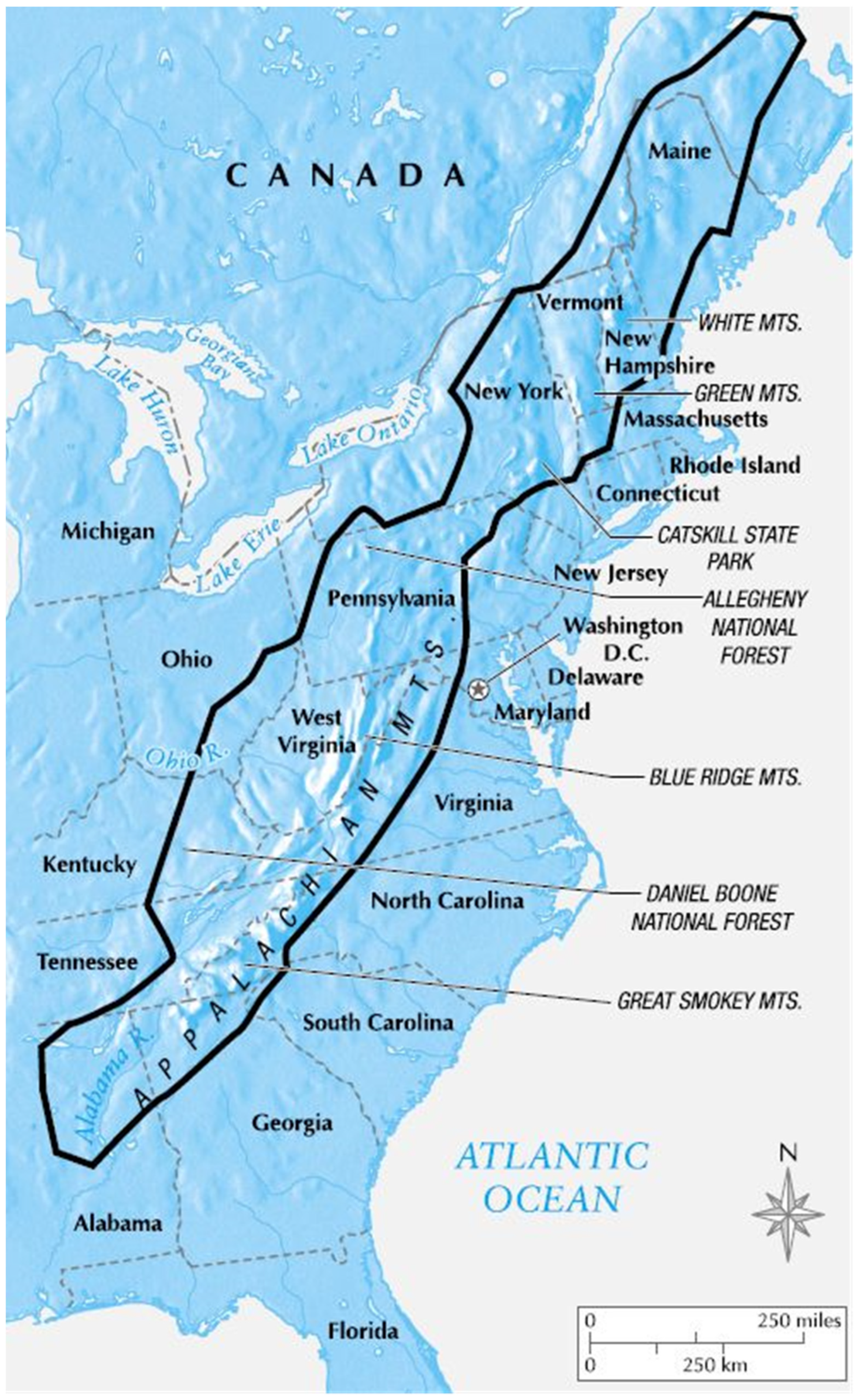
The Appalachian Mountains stretch from upper Alabama to Maine and pass through a total of 16 states along their length (Blakey 2008; USGS 2021, 2022a, 2022b, 2022c). The portion of this region deemed most resistant to climate change is that stretching from western North Carolina through western Pennsylvania, due to the width of the mountain range and the distance from the Atlantic coast (see, e.g., Brumfield 2021; Hurdle 2022; USGS 2022b). Ironically, this is the same region that was most environmentally damaged by coal mining from the mid-1800s to the end of the twentieth century (USGS 2022a, 2020b; Hurdle 2022).
1.2. Origins of the Appalachian Mountains
The geology of the Appalachians dates back more than 480 million years (Blakey 2008; USGS 2022a, 2022b, 2022c). Their origin resulted from the construction of the supercontinent Pangaea, with the Appalachians and Anti-Atlas mountains (now located in Morocco) being formed near the center of this ancient land mass. The Appalachian mountain range likely once reached elevations similar to those of the Alps and the Rocky Mountains before being eroded during the following millennia (Blakey 2008; USGS 2022a, 2022b, 2021). Figure One below depicts the Appalachian Mountain Range.
1.3. The Appalachian Basin
From north to south, the Appalachian range crosses New York, Pennsylvania, eastern Ohio, West Virginia, western Maryland, eastern Kentucky, western Virginia, eastern Tennessee, northwestern Georgia, and northeastern Alabama. The northern end of the Appalachian Basin extends offshore into Lakes Erie and Ontario, as far as the United States–Canada border. The entire range (Figure 1) is 1075 miles long from northeast to southwest and between 20 and 310 miles wide from northwest to southeast (Blakey 2008; USGS 2022a).
Importantly, it is the widest sections of the Appalachian range which will provide the most protection from the negative effects of climate change. These sections are found in North Carolina/Tennessee, Kentucky/Virginia/West Virginia, and Pennsylvania (Blakey 2008; USGS 2022a, 2022b). The wide area of mountainous terrain helps to mitigate against the possibility of droughts, high temperatures, and tornadic activity (Blakey 2008; USGS 2022b). This wide mountainous area serves to conserve rainfall, but will also be prone to flash flooding, due to the run-off from strong storms which will accumulate in the narrow valleys between the mountains (USGS 2021). Thus, flood control efforts, especially the strategic placement of perforated/flow-through dams, will be an important safety feature required for residents and businesses (USGS 2021). These mitigation efforts will be discussed later.
1.4. Coal, Oil, and Gas Production
The Appalachian Basin was one of the most important coal-producing regions in the United States and one of the biggest in the world (USGS 2021). Appalachian Basin bituminous coal was mined throughout the last three centuries. Bituminous coal deposits form a wedge that thickens from north to south, from Pennsylvania into southeast West Virginia and southwestern Virginia (Blakey 2008; USGS 2021); therefore, this is the section where coal mining was most prevalent (USGS 2021).
The Appalachian Mountains also have a long history of oil and natural gas production. The discovery of oil in Pennsylvania in 1859 marked the beginning of the oil and gas industry in the Appalachian Basin (American Chemical Society National Historic Chemical Landmarks n.d., USGS 2021). Over the next few decades, various entrepreneurs opened a large set of Appalachian oil and gas fields that extended from southern New York, across western Pennsylvania, central West Virginia, and eastern Ohio, to eastern Kentucky (Blakey 2008; USGS 2021). Several of these are still in operation (Blakey 2008; American Chemical Society National Historic Chemical Landmarks n.d.).
1.5. Surface Mining and Ecological Damage in Central Appalachia
As early as 1906, coal mine operators had begun surface mining (also called strip mining) in Appalachia (USGS 2021). This meant that coal was removed from deposits near the surface on mountaintops and along hillsides and flat areas. Surface mining causes serious ecological damage to the site because it removes topsoil to expose the coal seams and then sends debris and rocks down into the valleys and streams below (ScienceDirect 2013). Often, little to no effort was made by the mining companies to remediate the exposed surface once the coal deposit had been removed (Howell 2002; Spieles et al. 2019). This enabled water run-off to carry contaminated silt into the streams and rivers at the foot of the mountain or hillside (Howell 2002).
Although surface mining has recently been sharply curtailed in Central Appalachia, the earlier activities greatly increased the potential for flash flooding in areas where this type of mining occurred. Thus, West Virginia, eastern Kentucky, southwest Virginia, and western Pennsylvania will require substantial land restoration prior to the in-migration of new inhabitants seeking to escape climate change. In the section below, we outline the requirements for creating land areas that will be suitable for new communities of incoming climate refugees.
1.6. Preparing Appalachian Strip-Mined Land for Climate Refugee Settlements
As discussed above, the majority of Central Appalachian land available for resettlement by persons seeking to escape the effects of climate change has been subjected to strip-mining activity at some time in its recent history. A recent article by Spieles et al. (2019), cited above, provides a timeline for restoration given different types of strip mining activity and subsequent restoration efforts. They found that with little to no active efforts at restoration by the mining companies after abandoning a strip-mined site, full recovery of the pre-existing flora and fauna could take 30 to 45 years (!). This would, of course, place settlements into the post-2050 time period, at which point the Continental United States would be experiencing the full brunt of heat waves, floods, and coastal immersion caused by climate change (Hollingsworth 2019).
Thus, it will not be feasible to attempt to return Central Appalachia to its pre-mining topography and vegetation (Stutler et al 2022). However, the Spieles et al. (2019) study does report that aggressive intermediate remediation efforts can be effective in preventing hillside erosion (which contributes to flash flooding) and can make the ground surface suitable for habitation. In particular, they report that “reclaimed grassland” which has been planted with “warm season perennial grasses such as Panicum virgatum, Sorghastrum nutans and Andropogon gerardii, mixed with a variety of forbs and maintained with periodic prescribed burns” (p. 57), did prevent erosion. Such a ground surface would be usable for residential and business construction, as described in the next section of this paper. Below is an excerpt from an article on the use of these grasses in strip-mined western Pennsylvania:
“{The strip mined land} looked like a moonscape—the ground was filled with rocks and boulders, and the soil had poor water-holding capacity, all common problems after strip mining,” Hall said. “I honestly did not know how we were going to get anything to grow on it.”
However, he saw promise in one crop—switchgrass. “It’s a hardy, deep-rooted perennial grass that is known for its ability to grow despite poor soil quality, drought or flood. Its deep roots can break through rocky soil layers, improving long-term soil structure. It grows as high as 6 feet, requires little maintenance or fertilizer, and produces crops for up to 20 years. Switchgrass has many environmental and commercial benefits, such as providing shelter and food for wildlife, soil conservation, livestock feed, animal bedding, mulch and landscaping.” (Duke 2017).
2. Viable Options for Business and Residential Development
2.1. In Central Appalachia
The topography of Central Appalachia makes the construction of large-scale cities problematic. In addition to the necessity of strip mine remediation, much of the remaining land area is tree-covered, sloped, and/or mountainous—these are the same traits which help protect the Appalachian environment from extreme weather events such as hurricanes and tornadoes, as well as serving as a buffer against severe heating and cooling events (Hatfield 2017; USGS 2021). Thus, to maintain the viability of the Central Appalachian Region as a climate change haven, it is important for incoming business and residential development to “work with the land” rather than try to alter the existing terrain (Hatfield 2017). This means that the real estate development focus should be on small cities and towns of perhaps 20,000 to 30,000 residents.
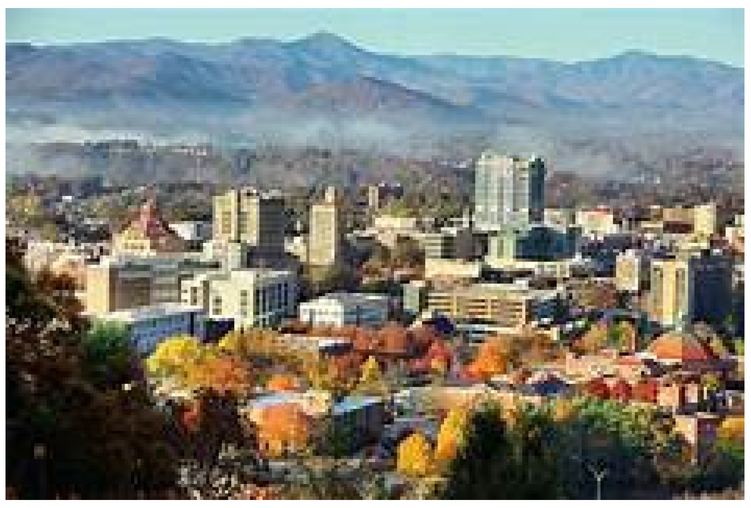
Currently, the largest city in the Central Appalachian region is Pittsburgh, PA, with a population of 303,000 persons. Pittsburgh sits in the natural basin created by three rivers which were vital to its industrial development during the 1800s and 1900s (www.PittsburghPA.gov). However, the rivers now have become a source of frequent flooding. See the photos (Figure 2 and Figure 3) below to compare the appearance of Pittsburgh before and after flooding event.
In fact, Pittsburgh has been inundated on several occasions from the 1800s onward, including a severe flooding event in 2022 (WPXI 2022). With climate change projections showing increased rainfall in the future, Pittsburgh’s flooding problems will become more severe. Thus, it is important for new residential and business development locating in the Central Appalachian Region to avoid locations in or near river valleys.
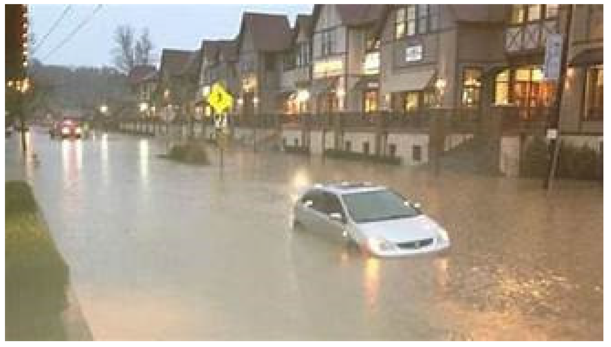
This caution is given additional support by weather events in the largest city at the other end of Central Appalachia—Asheville, NC. Asheville (see Figure 4) has a current population of 95,000 persons. Just as with Pittsburgh, Asheville was founded at the confluence of multiple rivers which were used for water transport during the 1800s (The City of Asheville n.d.). Additionally, just as with Pittsburgh, it is now experiencing frequent serious flooding (McDaniel 2021) See Figure 5 below.
“The National Weather Service has issued a Flash Flood Watch for the Asheville area through Wednesday morning as the remnants of Tropical Storm Fred move inland through the mountains. As much as 5 inches of rain could fall within 24 h, creating the potential for flooding conditions. Turn around, don’t drown.”
2.2. Potential Power Sources
Due to Appalachia’s unfortunate history as a coal-, natural-gas-, and oil-producing, region which contributed significantly to the current level of global warming, it is important to avoid using energy sources which are carbon-based. Wind power is possible as an energy source in the region, but the mountainous terrain makes it relatively inefficient (Appalachian Power n.d.a). Similarly, solar panels are currently in use on buildings and homes in the Appalachian region and may be especially useful as a supplemental energy source (Appalachian Power n.d.b). However, the paucity of large, flat, open spaces that could support solar installations, such as those found in the California, Arizona, Colorado, New Mexico, and Hawaii, makes this type of energy less viable in Appalachia.
Fortunately, there is an available clean energy source that will be ample for those re-locating to the Central Appalachian Region—hydro-powered generators. Just as out-of-control rivers and streams in the region cause flooding and erosion, these same waterways can be used to power generators capable of producing enough electricity to support communities of up to 50,000 persons (Kent and Risch 2006). These are not the concrete water-storage-and-spillway dams typical of the traditional Tennessee Valley Authority (Tennessee Valley Authority n.d.). However, as will be described below, hydropower generators are placed either in flowing rivers or in existing water reservoirs. Thus, they cause no disruption to the existing eco-system.
2.3. Hydro-Powered Generators
In the discussion below, various types and configurations of hydro-powered generators are described and discussed in terms of their ability to supply electricity to Central Appalachian communities.
Hydropower Turbines. There are two primary types of hydropower turbines: reaction and impulse. The type of hydropower turbine selected for a project is based on the height of the standing water to be input to the generator—referred to as “head”—and the flow, or volume, of water over time, at the site. The most commonly used turbines appropriate for Appalachia are described below.
Reaction Turbine. A reaction turbine generates power from the combined forces of pressure and moving water. A sluice is placed directly in the water stream, allowing water to flow over the generator’s blades. Reaction turbines are generally used for sites with lower water levels and higher speed flows and are the most common type currently used in the United States. Two common types of reaction turbines are propeller and bulb turbines (ScienceDirect 2022).
Propeller Turbine. A propeller turbine generally has three to six blades and propels water much like a boat engine. The pitch of the blades may be either fixed or adjustable.
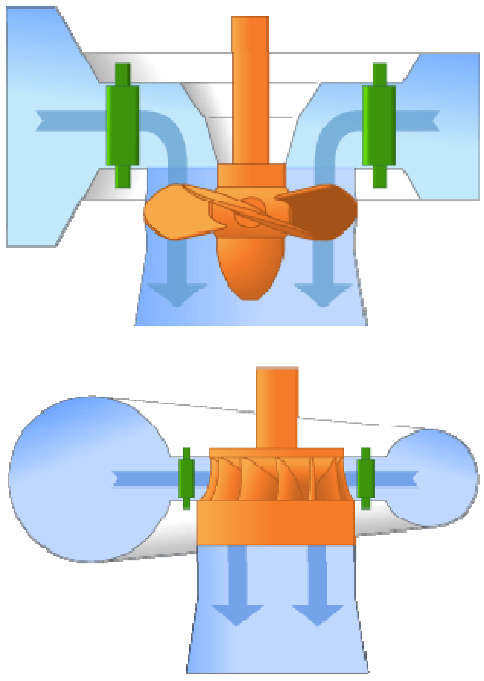
Bulb turbine. The bulb turbine and generator are a sealed unit placed directly into the water stream. The generator is attached directly to the perimeter of the turbine. The bulb turbine is shown below in Figure 6.
The tube turbine and the Francis turbine would also be suitable for use in Central Appalachia, and are detailed below.
Tube turbine: The tube turbine design uses a penstock design which bends just before or after the runner, allowing a straight-line connection to the generator (Office of Energy Efficiency & Renewable Energy n.d.). The tube turbine is shown above in Figure 7.
2.4. Francis Turbine
The Francis turbine (see Figure 8) features a runner with fixed blades. Water enters just above the runner, causing the blades to spin. Francis turbines work well in both horizontal and vertical placements; thus, they would be a desirable choice for Appalachian streams, rivers, and lakes.
2.5. Kinetic Energy Turbines
Kinetic energy turbines, also called free-flow turbines, generate electricity from the kinetic energy already present in flowing water. These systems are appropriate for Central Appalachia because they can operate in natural rivers and man-made water channels. Kinetic systems can utilize a river’s natural pathway; therefore, they do not require the diversion of water through man-made channels. Additionally, kinetic systems do not require large construction efforts, because they can be mounted on existing structures, such as bridges, docks, and channel walls. Various types are described below. (Office of Energy Efficiency & Renewable Energy n.d.).
2.6. Impulse Turbine
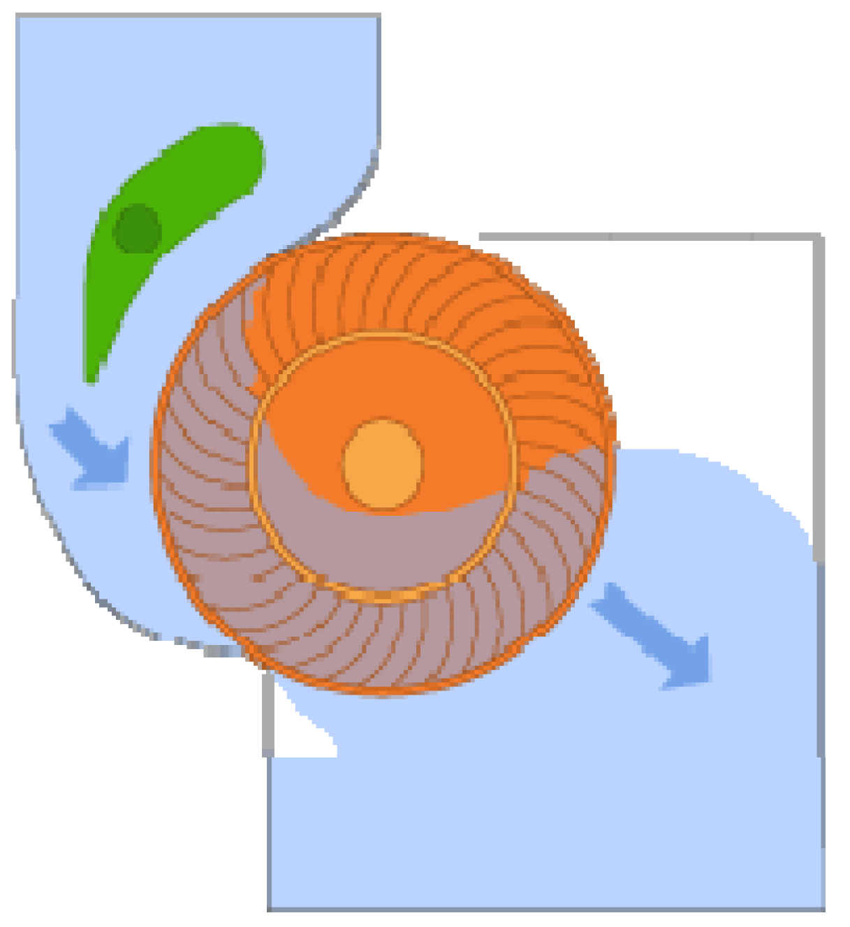
An impulse turbine generally uses a water stream which is directed to hit individual buckets on a runner. The water then flows out the bottom of the turbine after hitting the runner. These turbines are generally suitable for high water level, low-flow settings, such as a reservoir. The two main types of impulse turbine are Pelton and cross-flow turbines. Both these designs would be appropriate for use in Central Appalachia. The Pelton turbine is shown below in Figure 9.
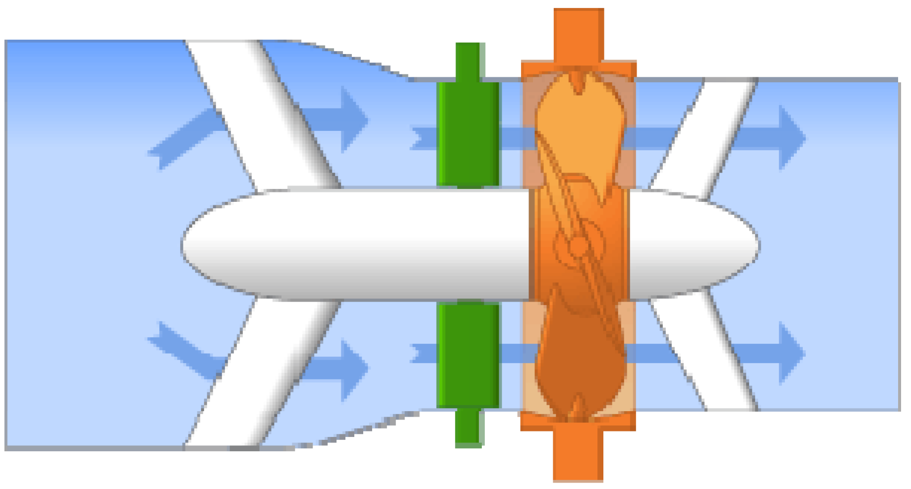
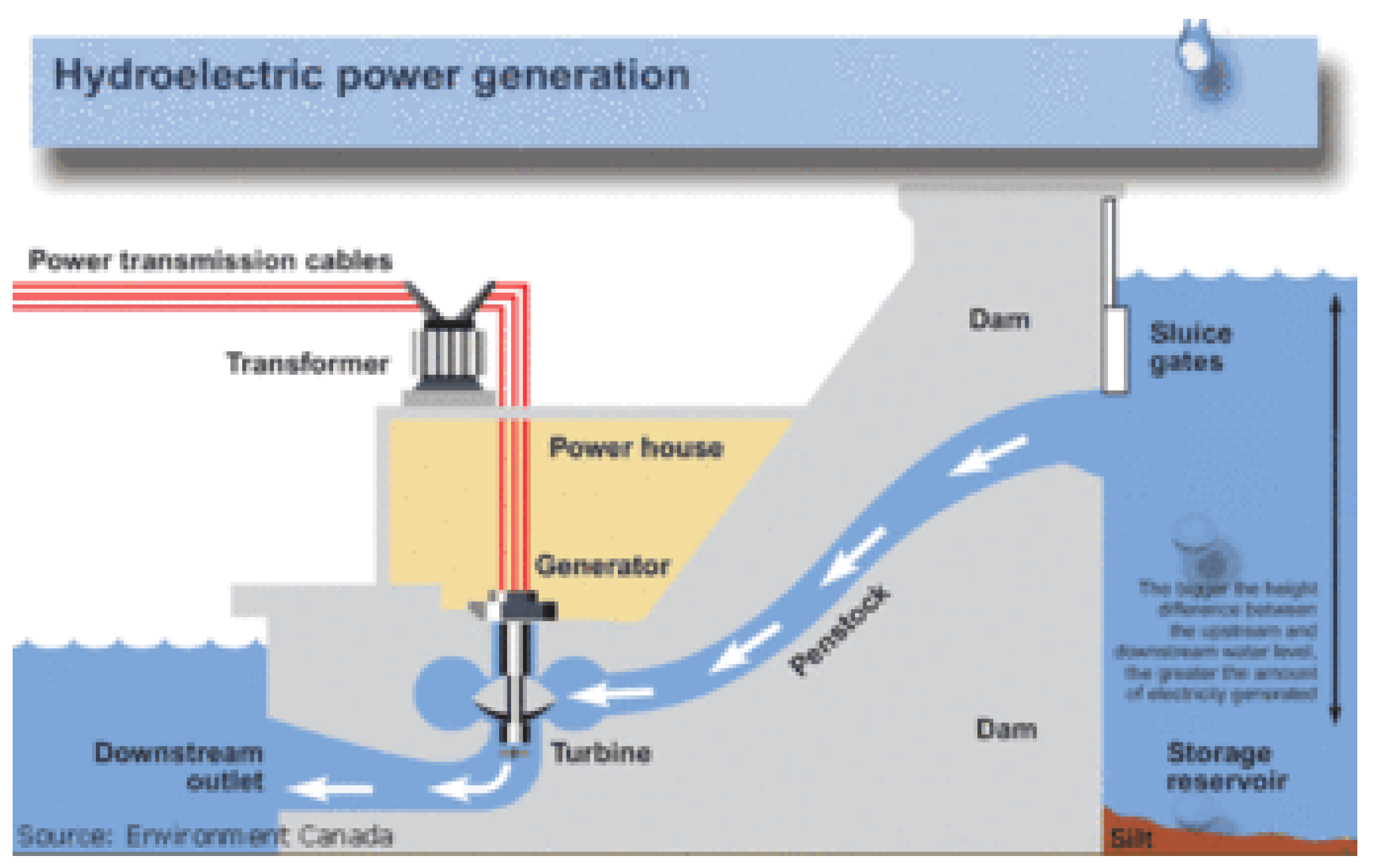
The cross-flow turbine, shown above in Figure 10, uses an elongated, rectangular nozzle directed against curved vanes on a cylindrical runner and allows water to flow through the blades twice. On the first pass, water flows from outside of the blades to the inside; the second pass flows from the inside back out. Notably, hydro-electric and coal-fired power plants, which are common in Central Appalachia, produce electricity in a similar way. In both cases, a power source is used to turn a propeller-like turbine. The diagram below in Figure 11 shows how flowing water from a storage reservoir moves through a turbine to create hydro-electric power.
2.7. Pumped Storage: Reusing Water for Peak Electricity Demand
Demand for electricity is not constant; there may be surges in the evening as residents return home and surges during extreme weather events. Fortunately, hydro-powered generators are more efficient at providing for these peak power demands during short periods than fossil-fuel and nuclear power plants. They accomplish this by recycling their input water supply and keeping an ample supply in reserve for heavy demand periods. These installations can be used to provide electrical power for towns of up to 30,000 residents in Central Appalachia by locating the hydro-electric pumping stations in existing reservoirs (GE Renewable Energy n.d.).
The International Renewable Energy Agency (IRENA) focuses on the use of hydropower facilities, especially in developing countries. They describe the cost/benefit ratio as being the best among clean energy options in terms of reliability and ease of maintenance. “Hydropower has historically provided the backbone of low-cost electricity in a significant number of countries around the world and is often the cheapest way to generate electricity where good, unexploited water resources exist… The LCOE of large-scale hydro projects at high-performing sites can be as low as USD 0.020/kWh, while the average costs of new capacity added in 2019 was slightly less than USD 0.050/kWh….For large hydropower projects, the weighted average LCOE of new projects added over the past decade in China and Brazil was USD 0.040/kWh, around USD 0.080/kWh in North America and USD 0.120/kWh in Europe.”
“For small hydropower projects (1–10 MW), the weighted average LCOE for new projects ranged between USD 0.040/kWh in China, 0.060/kWh in India and Brazil, and USD 0.130/kWh in Europe….The total installed costs for the majority of hydropower projects commissioned between 2010 and 2019, range from a low of around USD 600/kW to a high of around USD 4 500/kW.” (International Renewable Energy Agency n.d.).
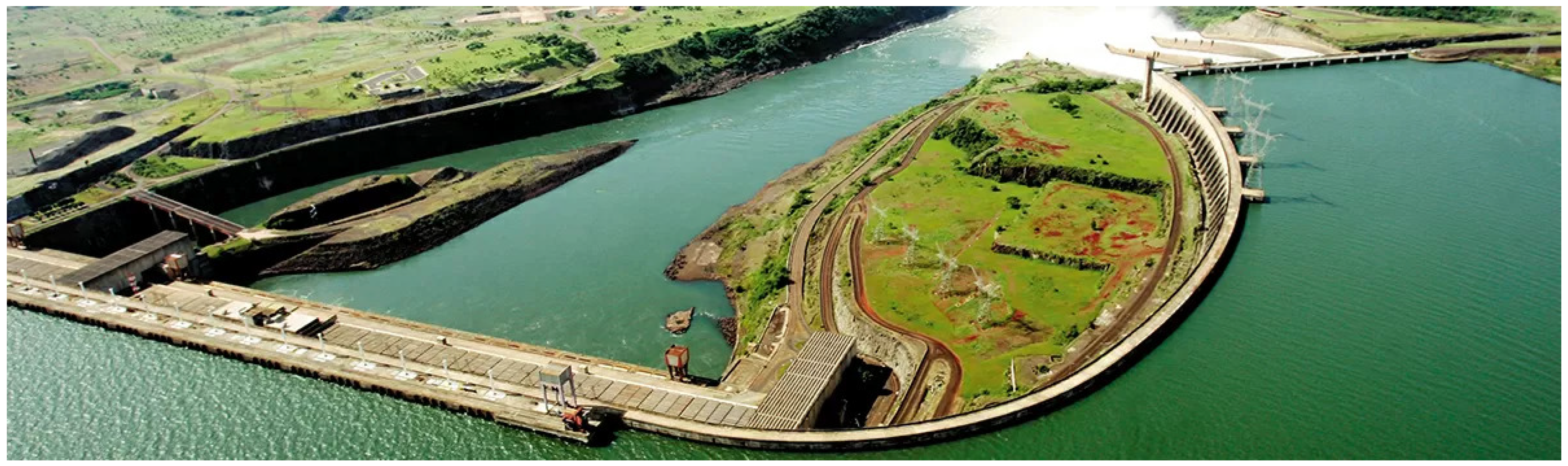
A contemporary hydro-power plant capable of supplying electric energy to a small town is shown below in Figure 12.
2.8. Construction and Utilization of Existing Water Reservoirs in Central Appalachia
Central Appalachia is forecast to have additional rainfall in the coming decades; therefore, hydro-power generators can be installed as the population increases by creating additional reservoirs near newly built towns. The reservoir acts similarly to a battery, storing power in the form of water when demands are low and producing maximum power during daily and seasonal peak periods. Hydro-electric generating units attached to reservoirs are able to start up quickly and make rapid adjustments in their output. They operate efficiently even when used for several hours. Pumped-storage reservoirs are relatively small; therefore, construction costs are generally low and make them desirable for current and future towns in Central Appalachia.
3. Mixed-Use Commercial and Residential Buildings
Another important component of future Central Appalachian Climate Haven communities will be the use of multi/mixed-use buildings which can provide residential housing, and also contain service businesses, restaurants, retail stores, and entertainment venues (Brownstoner n.d.). Such developments are becoming increasingly common in Canada and Europe, because they greatly reduce the need for personal automobiles and public transportation systems. Instead of commuting to work or driving to a shopping mall or restaurant, the developments enable residents to walk to these same venues in 15 min or less.
This greatly reduces transportation energy usage and provides residents with opportunities for exercise on their way to daily destinations. Residents may also choose to have their public school system located within walking distance, if they live in a mixed-use community. This would be desirable for the climate refuge communities being constructed in Central Appalachia, because it is anticipated that many will consist of families with young children.
3.1. Living in a Mixed-Use Development
As noted above, a mixed-use development is a real estate project which integrates retail, office, residential, hotel, and recreation facilities. Most of these developments encourage walking to and from activities and minimize or eliminate the need for automobiles and public transit systems, thus lowering greenhouse gas emissions. They are ideal for the small town settings already found in Central Appalachia and would serve well to house and employ new arrivals from climate-affected areas of the United States.
The new developments would be sited with access to new or existing water reservoirs fitted with hydro-pumping systems, in order to supply each town with adequate electrical support to independently operate the town. This would enable the total population of each town to reach up to 30,000 persons. From the residents’ perspective, a mixed-use development provides an environment in which they can live, work, and play in a community atmosphere. Commuting to work and school is minimized or eliminated, and there is little or no street traffic.
Specific components of the new mixed-use communities need to be mutually supportive and provide residents with a full range of residential, occupational, educational, recreational, and medical/dental options. If newly arrived residents come from specific areas of the United States, e.g., Miami, Dallas, Atlanta, or Phoenix, which are severely impacted by climate change, they may desire to migrate to Central Appalachia as a group and establish communities that have the same amenities, e.g., restaurants, outdoor sports, clubs, to which they are accustomed.
This would also likely be an attractive option for service and technology companies which decide to move from their present headquarters in, for example, Austin, Texas, and bring their entire operation and workforce to Central Appalachia. Their corporate identity and lifestyle could be preserved, and their desired support services and amenities could be reconstructed in Central Appalachia, likely at an operating cost far lower than their present circumstances.
3.1.1. Ecological Residential Housing
Other incoming climate-haven-seekers may arrive as individuals or families not affiliated with a large company. For these persons, many ecologically compatible housing options are available (see, e.g., The Good Trade n.d.; Home Stratosphere n.d.).
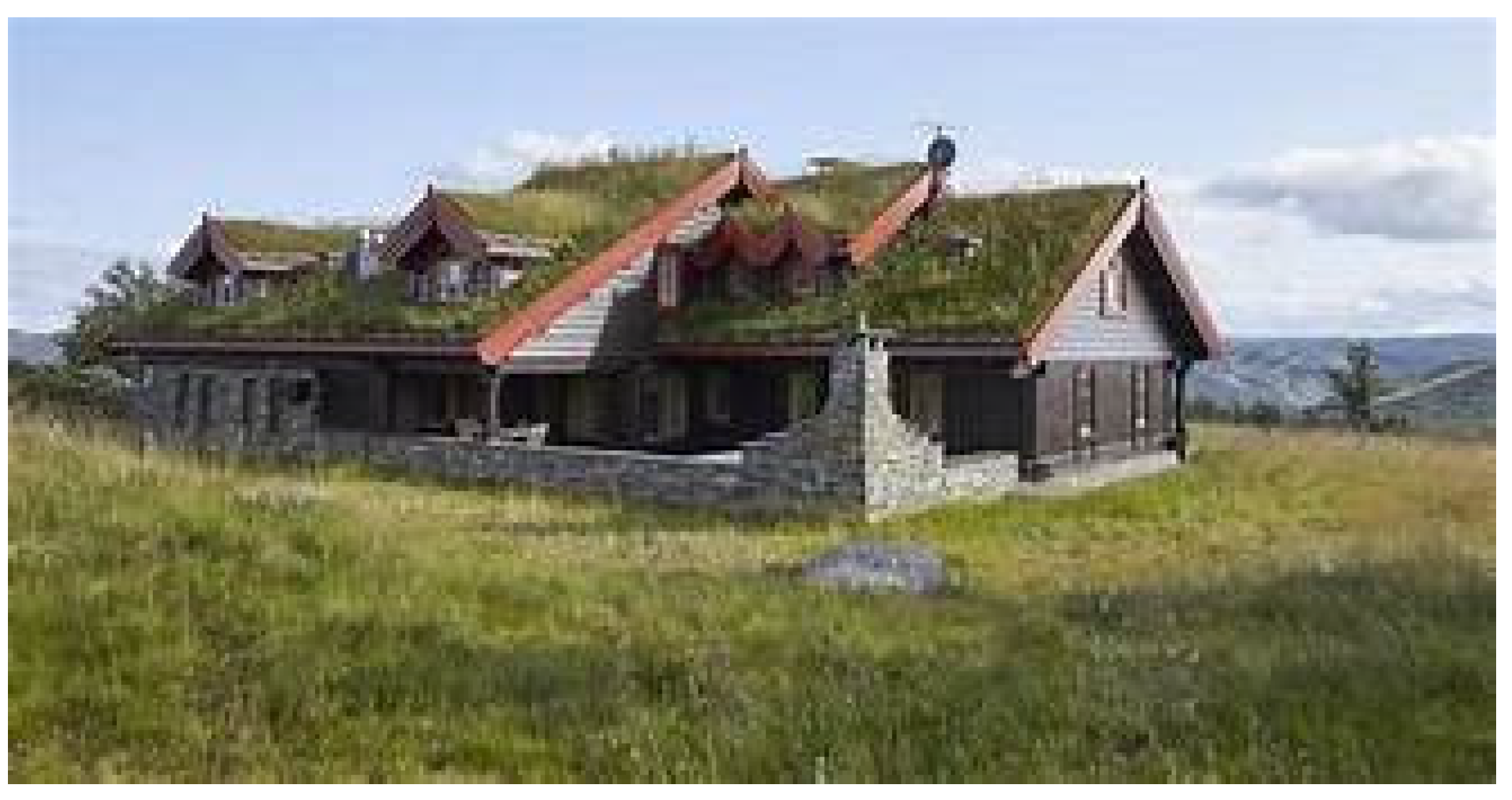
These range in size from small bungalows to large family homes. Much of the land in Appalachia is located on sloping ground and hillsides; therefore, it is important to consider family housing plans that are ecologically sound and can fit comfortably into the terrain without disrupting the surface soil. European countries such as Sweden and Norway, which also have sloping building sites, have pioneered these designs. The design shown in Figure 13 below uses the hillside to save on energy usage. The design in Figure 14 employs regional vegetation on its roof to preserve energy. The house designs in Figure 14 and Figure 15 are constructed from natural limestone found in Appalachia. They also use prairie grass on the roof to reduce energy consumption.
What is consistent about these housing designs is the importance of working within the existing ecological system. Most of the residences use natural and/or recycled materials to reduce heating and cooling costs. Often, the energy costs of these residences are one-half to one-third of those in conventional residences (Folk 2022).
3.1.2. Flood Control Measures
Much of the Central Appalachian terrain consists of hillsides and ridges; therefore, the forecasted increase in future rainfall for the region will create greater possibilities of flooding, especially in the valleys. For example, the small, valley town of Hurley, VA, was severely damaged by flash flooding in 2021 (United Way of Southwest Virginia n.d.).
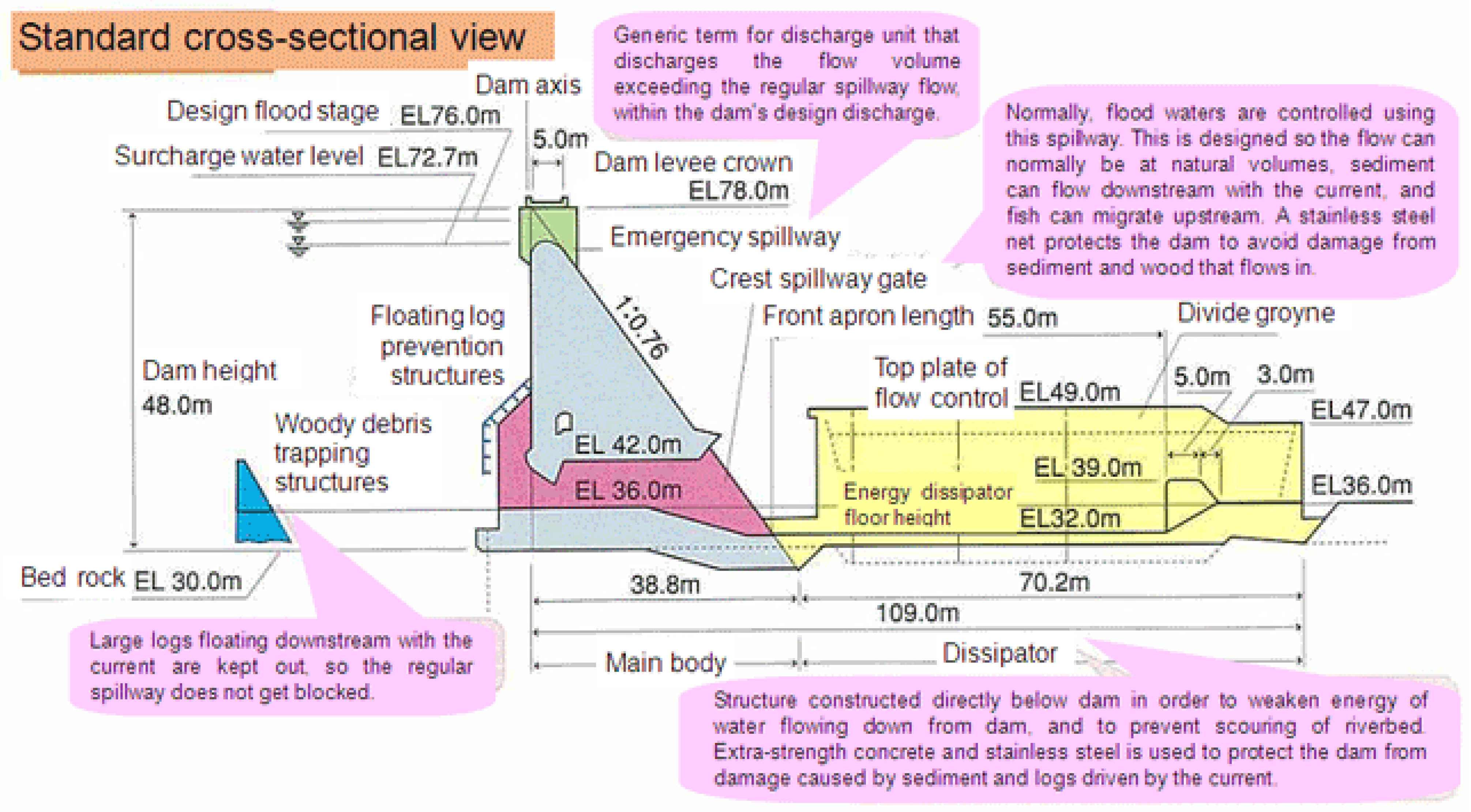
Thus, as new residential and township areas are developed, it will be important to install perforated/flow-through dams to divert the rain waters away from residential and business areas. These have recently been developed by the United Nations for use in flood-prone regions such as Malaysia, Bangladesh, India, and China (see, e.g., CTCN 2017; CTCN n.d.).
These dams are relatively inexpensive and take less time to construct than a conventional water reservoir dam; they are also highly compatible with ecological preservation. Flow-through dams are constructed solely for the purpose of flood control and the mitigation of flood risk in downstream communities and ecosystems. Unlike the reservoir dams discussed previously, which are built primarily for water storage and power generation, flow-through dam spillways are constructed at the same height as the riverbed level, allowing the river to continue its natural flow during normal conditions.
When water levels rise above the spillway, the dam restricts the amount flowing through the opening, decreasing peak flood flow. Flow-through dams minimally affect a river’s natural flow; thus, negative environmental and socioeconomic impacts, such as sediment accumulation, restriction of water flow to downstream communities and ecosystems, and breaching during extreme flood events, can be minimized or avoided altogether (CTCN n.d.)
3.2. Locating Flow-Through Dams for Flood Control
Flow-through dams should be constructed in high flood-risk areas, particularly those with important civic infrastructure and commercial assets. Planners, local decision makers, and construction engineers are the typical stakeholders involved in construction site choice, as well as spillway and wall height selection, the setting of desired river flow rates, and dam carrying capacity. Operational management typically involves general maintenance and the occasional clearing of sediments or other accumulations that may obstruct optimal water flow (CTCN n.d.).
Traditional concrete spillway dams are for the purpose of water storage (most current TVA dams in Central Appalachia are this type); therefore, the removal of sediment is difficult and there are negative environmental impacts, such as water quality deterioration. In contrast, flow-through perforated dams enable sediment removal using conventional dredging equipment, so the impact on the environment is small (Fenton and Griffiths 2008) In Figure 16 below, the structure of a flow-through dam appropriate for use in Central Appalachia is depicted. The dam is designed so that large logs in the river stream are removed and the dam is not blocked.
Current and incoming Central Appalachian residents would likely support the installation of flow-through dams in their communities, due to their low cost, low maintenance, and enhancement of property values. There is little or no damage to the natural environment and existing eco-systems, including fishing, boating, and other water sports (Fenton and Griffiths 2008).
3.3. Discussion
Climate change in the United States—and the rest of the world—is a reality (Climate Watch 2021; Environment 2021; Knickmeyer and Borenstein 2021; Liu and Raftery 2021; Patz et al. 2014; UN News 2021; Vince 2022; World Resources Institute 2020). The past decade’s efforts to mitigate this destructive process, both nationally and globally, have been failures (Vince 2022; World Resources Institute 2020). Given that nations tend to act in their own self-interest economically and politically, it is unlikely that sufficient efforts can or will be made to halt the increase in greenhouse gas emissions over the coming decades (Knickmeyer and Borenstein 2021).
Wealthy countries such as the United States have shown themselves to be reluctant to reduce their own use of carbon-based fuels and even more reluctant to assist less affluent countries in reducing their usage of coal, wood, and petroleum as energy sources (EPA 2021). Forests in less-developed countries continue to be burned to provide land for agriculture, further reducing the ability of the planet to absorb carbon emissions (Environment 2021). It is therefore appropriate that countries identify areas within their own borders which can serve as climate refuges for their populations. These refuge regions must be protected and, if possible, enhanced with the resources necessary to enable them to shelter as many persons as possible in an environmentally sound manner.
In the American motion picture genre of ‘disaster films’, the threat to our planet is usually depicted as an asteroid, an invasion by aliens from ‘outer space’, giant sea monsters, predatory sharks, or natural disasters such as volcanoes, earthquakes, floods, and tornadoes. The members of the audience eat their popcorn, drink their sodas, and then, at the conclusion of the film, walk out of the theater to their cars and drive home—where they will be safe. In a decade or so, this will no longer be true. Additionally, for a large proportion of Americans now living in California, Texas, Florida, Arizona, New Mexico, Oregon, Oklahoma, Utah, Nevada, and along the Gulf Coast, “home” is already not safe.
Central Appalachia is the best, and likely only, hope for preserving communities free from the threat of climate-spawned disasters in the continental United States in the near future. It is vital that we begin developing ecologically sound communities there now. This will require accepting the idea that ‘perfect’ solutions are not available. It will not be possible to return most strip-mined lands to the forested terrain they once enjoyed prior to being mined. Most of the reclaimed lands will likely have to initially be planted in prairie grasses, to which deciduous and conifer tree species can later be added.
It will also be necessary to work closely with the residents already living in Central Appalachia and seek their support and approval before attempting to transfer large numbers of ‘outsiders’ into their communities. It is likely that the incoming climate refugees will need to be vetted for social and cultural similarity to those persons already residing in Central Appalachia; this will probably mean the recruitment focus should be on individuals and families living in the southwestern and southeastern areas of the United States.
An additional, vitally important consideration is the financial cost and timeline for implementing the necessary remediation and construction activities in Central Appalachia. According to the most recent estimates (see, e.g., Vince 2022), extreme weather events will become increasingly common in North America by 2030; by 2050, many of the affected portions of the United States will become uninhabitable. This means that land preparation through grass-coverage and site location for future climate haven communities in Central Appalachia must begin at once. The cost to create the proposed climate haven communities will be enormous—easily in the billions of dollars (see Vince 2022). Where is the funding to come from?
There are four potential funding sources, and it is likely that a combination of these will be required to effectively create the new communities in the short time available. The largest source is the U.S. Federal Government, which could enact emergency legislation designating specific areas in Central Appalachia as climate haven sites and allocate sufficient funds to begin surface-mined land restoration, the installation of hydro-electric generators, and initial housing and municipal building site preparation. The political challenges here will include hesitance on the part of conservative US Senators and Representatives to enlarge the Federal spending deficit in order to build these new communities—especially when some of the most powerful of these politicians publicly deny the reality and threat of climate change.
A second source of funding is the Appalachian Regional Commission (Appalachian Regional Commission n.d.). This Commission receives funding from the Federal Government on an annual basis to support projects in Appalachia intended to improve the regional economy and the health and employment opportunities of persons living there. The 2022 budget for the ARC is USD 235 million, which was a 31% increase over the allocation in 2021 (ARC.gov/budget). Obviously, this amount will provide only a small portion of what is required to transform Central Appalachia into a climate change haven by 2030.
Additionally, the projects funded by the ARC usually receive only USD 50,000 to USD 1,000,000 per request, and these are usually awarded to projects such as upgrading sewer lines, repaving roads, workforce training, medical clinics, and arts–culture–tourism ventures in a single location. The ARC does not have experience in funding and supervising multi-year, multi-purpose projects addressing climate change—especially when those span a multi-state area.
A third source would be for the Central Appalachian states to individually allocate state funds to design and build climate change communities. This would give each state control over the amenities and locations they want to provide for incoming climate change migrants. West Virginia, for example, could re-purpose virtually its entire territory as a climate change haven. This would greatly increase the future tax revenue collected, but would require enormous initial investment by a state that presently has one of the lowest living standards in the United States (wvpolicy.org/checking-in-on-west-virginia). It would also require altering the pro-fossil-fuel attitudes of many of the powerful political and business forces in the state.
A fourth option would be to encourage local counties and towns in Central Appalachia to begin establishing climate haven communities in partnership with real estate developers experienced in constructing multi-use municipal communities, ecological housing, hydro-power electrical installations, and flow-through dams. Existing surface-mined terrain could be planted with appropriate prairie grasses in projects undertaken by local community service organizations and student groups. Climate haven communities would then be designed and constructed in accordance with local building codes (subject to environmental vetting) and available sites.
This latter option would help ensure local support for the new climate haven communities and also initiate the testing of alternative configurations for housing, transportation, educational, recreational and medical facilities. Likely some models will work better in certain locations than in others. This “learning curve” should be monitored and communicated as new sites are developed to ensure the most efficient use of resources.
We truly are all in this together. The sooner we accept the coming climatic events as reality, the better equipped we will be to deal with them effectively.
Funding
This research received no external funding.
Institutional Review Board Statement
Not applicable.
Informed Consent Statement
Not applicable.
Data Availability Statement
All data used in the study are cited in the study.
Conflicts of Interest
The author has no conflicts of interest.
References
- Accelerating America’s Pledge (PDF). 2019, New York: Bloomberg Philanthropies with University of Maryland Center for Global Sustainability, Rocky Mountain Institute, and World Resources Institute.
- American Chemical Society National Historic Chemical Landmarks. n.d. Development of the Pennsylvania Oil Industry. Available online: http://www.acs.org/content/acs/en/education/whatischemistry/landmarks/pennsylvaniaoilindustry.html (accessed on 12 July 2022).
- Appalachian Power. n.d.a Wind Technology: The Winds of Change Bring Power. Available online: https://www.appalachianpower.com/clean-energy/renewable/wind (accessed on 29 May 2022).
- Appalachian Power. n.d.b Solar Energy. Available online: https://www.appalachianpower.com/clean-energy/renewable/solar/ (accessed on 28 May 2022).
- Appalachian Regional Commission. n.d. Appalachian Regional Commission. Available online: https://www.arc.gov/ (accessed on 29 May 2022).
- Blakey, Ron. 2008. Paleogeography and Geologic Evolution of North America. Flagstaff: Global Plate Tectonics and Paleogeography, Northern Arizona University. [Google Scholar]
- Borunda, Alejandra. 2021. ‘Megadrought’ persists in western U.S., as another extremely dry year develops. National Geographic, May 7. [Google Scholar]
- Brownstoner. n.d. What Is a Mixed-Use Property? A Guide to the Residential-Commercial Hybrid. Available online: https://www.brownstoner.com/guides/apartment-home-types/mixed-use/ (accessed on 30 May 2022).
- Brumfield, Nick. 2021. Climate Change and the Coming Appalachia Land Rush. Expatalachians, July 13. [Google Scholar]
- Canon, Gabrielle. 2021. ‘Truly an emergency’: How drought returned to California—And what lies ahead. The Guardian, June 7. [Google Scholar]
- Carlisle, Liz, Maywa Montenegro de Wit, Marcia S. DeLonge, Alastair Iles, Adam Calo, Christy Getz, Joanna Ory, Katherine Munden-Dixon, Ryan Galt, Brett Melone, and et al. 2019. Transitioning to Sustainable Agriculture Requires Growing and Sustaining an Ecologically Skilled Workforce. Frontiers in Sustainable Food Systems 3: 96. [Google Scholar] [CrossRef]
- Chow, Denise. 2021. How climate change ‘loads the dice’ for heat waves. NBC, June 30. [Google Scholar]
- Climate Watch. 2021. Historical GHG Emissions/Global Historical Emissions. Climate Watch. Available online: ClimateWatchData.org (accessed on 15 June 2022).
- CTCN. 2017. Flow-through dams. Available online: http://www.ctc-n.org/resources/flow-through-dams (accessed on 12 May 2022).
- CTCN. n.d. Flow-Through Dam for Flood Control. Available online: https://www.ctc-n.org/technologies/flow-through-dam-flood-control (accessed on 26 June 2022).
- Duke, Amy. 2017. Research focuses on reclaiming strip-mine sites for biofuel crop production. Available online: https://www.psu.edu/news/research/story/research-focuses-reclaiming-strip-mine-sites-biofuel-crop-production/ (accessed on 12 July 2022).
- Environment. 2021. Environment 2021: What Comes Next? | Environmental Law Institute. Available online: www.eli.org/research-report/environment-2021 (accessed on 12 July 2022).
- EPA. 2021. Climate Change Indicators: U.S. and Global Temperature. Climate Change Indicators in the United States | US EPA. Available online: www.epa.gov/climate-indicators (accessed on 5 June 2022).
- Fenton, Gordon A., and D. V. Griffiths. 2008. Flow through Earth Dams. In Risk Assessment in Geotechnical Engineering. New York: John Wiley & Sons, pp. 297–310. [Google Scholar]
- Folk, Emily. 2022. How Eco-Friendly Homes Save Energy. Available online: www.cleantechloops.com/eco-friendlyenergy (accessed on 12 July 2022).
- GE Renewable Energy. n.d. Large Hydro Generators. Available online: https://www.ge.com/renewableenergy/hydro-power/large-hydropower-solutions/generators (accessed on 28 June 2022).
- Hatfield, Samantha Chisholm. 2017. The Importance of Traditional Ecological Knowledge (TEK) When Examining Climate Change. Cambridge: Union of Concerned Scientists. [Google Scholar]
- Hollingsworth, Julia. 2019. Climate change could pose ‘existential threat’ by 2050: Report. CNN. June 4. Available online: https://edition.cnn.com/2019/06/04/health/climate-change-existential-threat-report-intl/index.html (accessed on 26 June 2022).
- Home Stratosphere. n.d. 12 Types of Eco-Friendly Houses. Available online: https://www.homestratosphere.com/types-of-eco-friendly-homes/ (accessed on 18 May 2022).
- Howell, Benita J. 2002. Culture, Environment and Conservation in the Appalachian South. Available online: https://books.google.com.hk/books/about/Culture_Environment_and_Conservation_in.html?id=vcXWAAAAMAAJ&redir_esc=y (accessed on 15 May 2020).
- Hurdle, Jon. 2022. As Climate Fears Mount, Some are Relocating Within the US. Science, April 9. [Google Scholar]
- International Renewable Energy Agency. n.d. Hydropower. Available online: https://www.irena.org/costs/Power-Generation-Costs/Hydropower (accessed on 6 June 2022).
- James, Ian. 2022. Western megadrought is worst in 1,200 years, intensified by climate change, study finds. Los Angeles Times, February 14. [Google Scholar]
- Kent, Calvin, and Christine Risch. 2006. Energy Efficiency and Renewable Energy in Appalachia: Policy and Potential. Available online: https://www.arc.gov/wp-content/uploads/2020/06/arc_renewable_energy_full.pdf (accessed on 8 June 2022).
- Knickmeyer, Ellen, and Seth Borenstein. 2021. Back in Paris Pact, US Faces Tougher Climate Steps Ahead. New York: Associated Press. [Google Scholar]
- Knutson, Thomas, and Gabriel Vecchi. 2019. Historical Atlantic Hurricane and Tropical Storm Records: How Well Do We Know the Historical Cyclone Record? Washington, DC: Geophysical Fluid Dynamics Laboratory, National Oceanic & Atmospheric Administration.
- Kohut, Abrahm, and Meridith Lustgarten. 2022. Climate Change Will Force a New American Migration. Available online: www.propublica.org/article/climate-change-will (accessed on 12 July 2022).
- Liu, Peiran R., and Adrian E. Raftery. 2021. Country-based rate of emissions reductions should increase by 80% beyond nationally determined contributions to meet the 2 °C target. Communications Earth & Environment 2: 29. [Google Scholar]
- McDaniel, Polly. 2021. Asheville roads reopen following flooding—The City of Asheville. Available online: https://www.ashevillenc.gov/news/city-of-asheville-offices-to-close-at-4-p-m-staff-ready-to-respond-to-tropical-storm-fred/ (accessed on 12 July 2022).
- NASA. 2022. Global Climate Change. Available online: https://climate.nasa.gov/ (accessed on 12 May 2022).
- National Institute of Environmental Health Sciences. 2022. Available online: https://www.niehs.nih.gov/health/topics/agents/climate-change/ (accessed on 12 July 2022).
- Office of Energy Efficiency & Renewable Energy. n.d. Types of Hydropower Turbines. Available online: https://www.energy.gov/eere/water/types-hydropower-turbines (accessed on 12 July 2022).
- Patz, Jonathan, Howard Frumkin, Tracey Holloway, Daniel J. Vimont, and Andrew Haines. 2014. Climate Change: Challenges for Global Health. Journal of the American Medical Association. [Google Scholar] [CrossRef] [PubMed]
- PewResearch.org. 2020. As Economic Concerns Recede, Environmental Protection Rises on the Public’s Policy Agenda/Partisan Gap on Dealing with Climate Change Gets even Wider. Washington, DC: Pew Research Center. [Google Scholar]
- Schiermeier, Quirin. 2021. Climate change made North America’s deadly heatwave 150 times more likely. Nature. [Google Scholar] [CrossRef] [PubMed]
- ScienceDirect. 2013. Strip Mining. Available online: https://www.sciencedirect.com/topics/earth-and-planetary-sciences/strip-mining (accessed on 12 July 2022).
- ScienceDirect. 2022. Reaction Turbine. Available online: https://www.sciencedirect.com/topics/engineering/reaction-turbine (accessed on 12 July 2022).
- Spieles, Douglas J., Emily Bennett, William Weems, and Rebecca Swab. 2019. Vegetation function and Diversity on Re-claimed Surface Mined Lands of Southeastern, Ohio. Journal of American Society of Mining and Reclamation 8: 52–66. [Google Scholar] [CrossRef]
- Stutler, K., E. Pena-Yewtukhiw, and Jeffrey Skousen. 2022. Mine soil health on surface mined lands reclaimed to grassland. Geoderma 413: 115764. [Google Scholar] [CrossRef]
- Tennessee Valley Authority. n.d. Available online: https://www.tva.com/ (accessed on 3 June 2022).
- The City of Asheville. n.d. The City of Asheville. Available online: https://www.ashevillenc.gov/ (accessed on 12 July 2022).
- The Good Trade. n.d. 10 Eco-Friendly Homes Living in the Future. Available online: https://www.thegoodtrade.com/features/eco-friendly-homes (accessed on 23 May 2022).
- U.S. Government Accountability Office. 2018. Climate Change: Analysis of Reported Federal Funding. Available online: https://www.gao.gov/products/gao-18-223 (accessed on 12 May 2022).
- UN News. 2021. Secretary-General welcomes US return to Paris Agreement on Climate Change. UN News, United Nations, January 20. [Google Scholar]
- United States Environmental Protection Agency. 2021. Climate Change Research. Available online: https://www.epa.gov/climate-research (accessed on 12 May 2022).
- United Way of Southwest Virginia. n.d. Hurley, VA Flood Relief. Available online: www.unitedwayswva.org/hurley-va-flood-relief (accessed on 30 September 2022).
- USGS. 2021. Geology of the Great Smoky Mountains; New Haven: USGS.
- USGS. 2022a. National Assessment of Coastal Vulnerability to Sea-Level Rise: Preliminary Results for the U.S. Pacific Coast; New Haven: USGS.
- USGS. 2022b. National Assessment of Coastal Vulnerability to Sea-Level Rise: Preliminary Results for the U.S. Atlantic Coast; New Haven: USGS.
- USGS. 2022c. National Assessment of Coastal Vulnerability to Sea-Level Rise: Preliminary Results for the U.S. Gulf of Mexico Coast; New Haven: USGS.
- Vince, Gaia. 2022. Nomad Century. New York: Flat-Iron Books. [Google Scholar]
- Williams, A. Park, Benjamin I. Cook, and Jason E. Smerdon. 2022. Rapid intensification of the emerging southwestern North American megadrought in 2020–2021. Nature Climate Change 12: 232–34. [Google Scholar] [CrossRef]
- World Resources Institute. 2020. 4 Charts Explain Greenhouse Gas Emissions by Countries and Sectors. Washington, DC: World Resources Institute. [Google Scholar]
- WPIX. 2022. Flooding Continues to Be an Issue across Pittsburgh Area. WPXI, February 18. Available online: https://www.wpxi.com/news/local/flooding-continues-be-an-issue-across-pittsburgh-area/8a48d2a7-82ca-4b15-a16c-7fe4755a956a/ (accessed on 12 July 2022).
- Yang, Maya. 2021. Six in 10 Americans ‘alarmed’ or ‘concerned’ about climate change—Study. The Guardian, January 13. [Google Scholar]
Figure 1.
Map of the Appalachian (above).

Figure 2.
Pittsburgh, PA.

Figure 3.
Pittsburgh, PA, flooding in 2021.

Figure 4.
Asheville, NC.

Figure 5.
Asheville during the 2022 flood.

Figure 6.
Bulb turbine.

Figure 7.
Tube turbine.

Figure 8.
Francis turbine.

Figure 9.
Pelton turbine.

Figure 10.
Cross-flow turbine.

Figure 11.
Falling water produces hydro-electric power. Credit: Tennessee Valley Authority.

Figure 12.
Large hydro-power installation capable of supplying electricity to a population of 30,000 persons. Credit: General Electric Corporation.
Figure 12.
Large hydro-power installation capable of supplying electricity to a population of 30,000 persons. Credit: General Electric Corporation.

Figure 13.
This house is incorporated into the surrounding hillside, which reduces energy usage.

Figure 14.
The house above uses vegetation on the roof to provide energy conservation.

Figure 15.
This small house uses local stone, which is abundant in Central Appalachia, and also has a grass roof covering to provide insulation and reduce energy usage.
Figure 15.
This small house uses local stone, which is abundant in Central Appalachia, and also has a grass roof covering to provide insulation and reduce energy usage.

Figure 16.
Diagram of a flow-through dam for flood control purposes (United Nations).

Publisher’s Note: MDPI stays neutral with regard to jurisdictional claims in published maps and institutional affiliations. |
© 2022 by the author. Licensee MDPI, Basel, Switzerland. This article is an open access article distributed under the terms and conditions of the Creative Commons Attribution (CC BY) license (https://creativecommons.org/licenses/by/4.0/).
Share and Cite
MDPI and ACS Style
Hirschman, E.C. Climate Change Migration and the Economic Rebirth of Central Appalachia. Soc. Sci. 2022, 11, 462. https://doi.org/10.3390/socsci11100462
AMA Style
Hirschman EC. Climate Change Migration and the Economic Rebirth of Central Appalachia. Social Sciences. 2022; 11(10):462. https://doi.org/10.3390/socsci11100462
Chicago/Turabian StyleHirschman, Elizabeth C. 2022. "Climate Change Migration and the Economic Rebirth of Central Appalachia" Social Sciences 11, no. 10: 462. https://doi.org/10.3390/socsci11100462
Note that from the first issue of 2016, this journal uses article numbers instead of page numbers. See further details here.