
Advancing Urban Life: A Systematic Review of Emerging Technologies and Artificial Intelligence in Urban Design and Planning

Abstract
:1. Introduction
1.1. Research Background
1.2. The Wide Application of Artificial Intelligence Technologies
1.3. Advances in Artificial Intelligence Technologies and the Interrelation of Urban Planning
1.4. The Value of Geographic Design in Regional Spatial Applications
1.5. Research Questions
2. Method
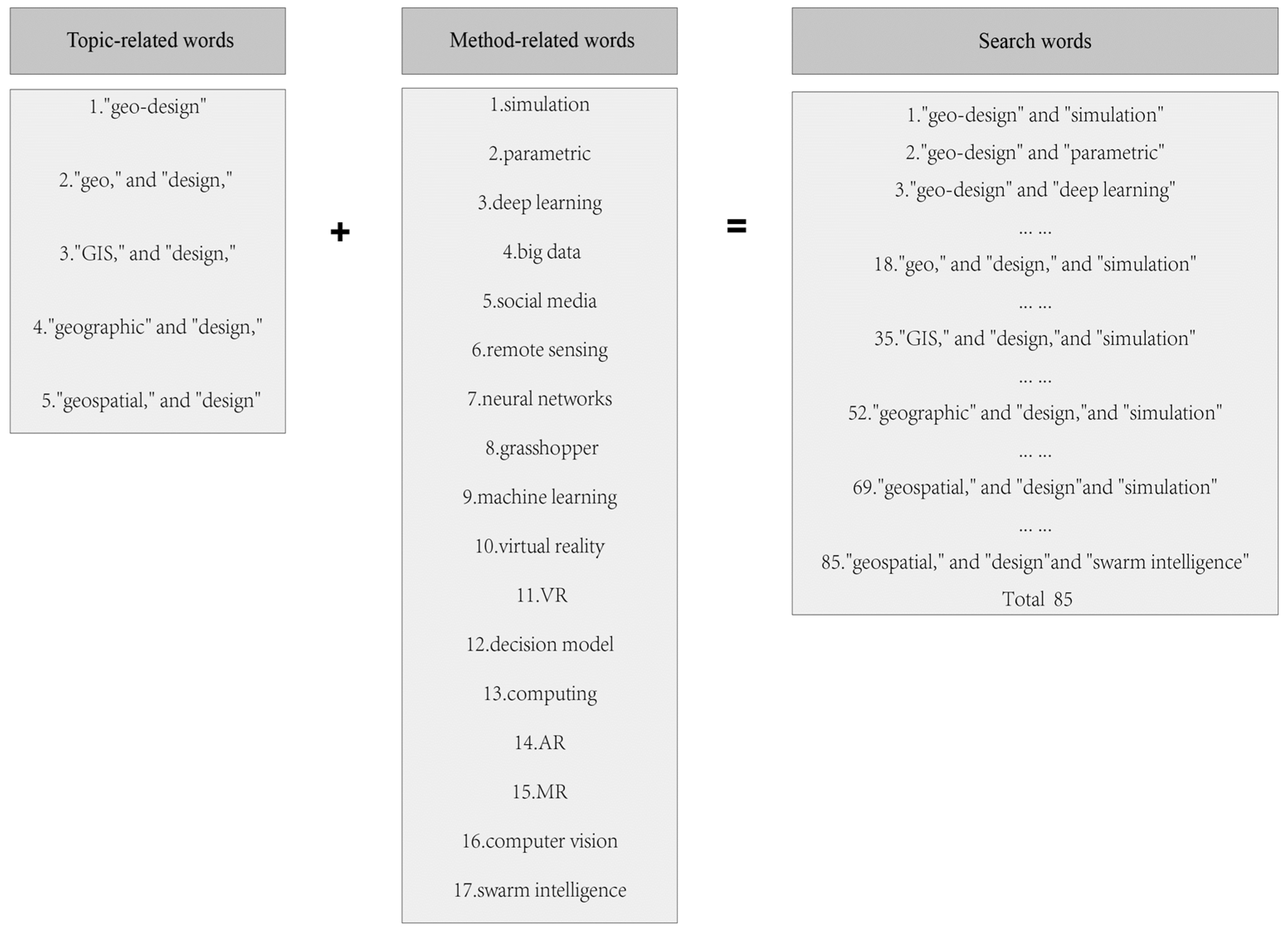
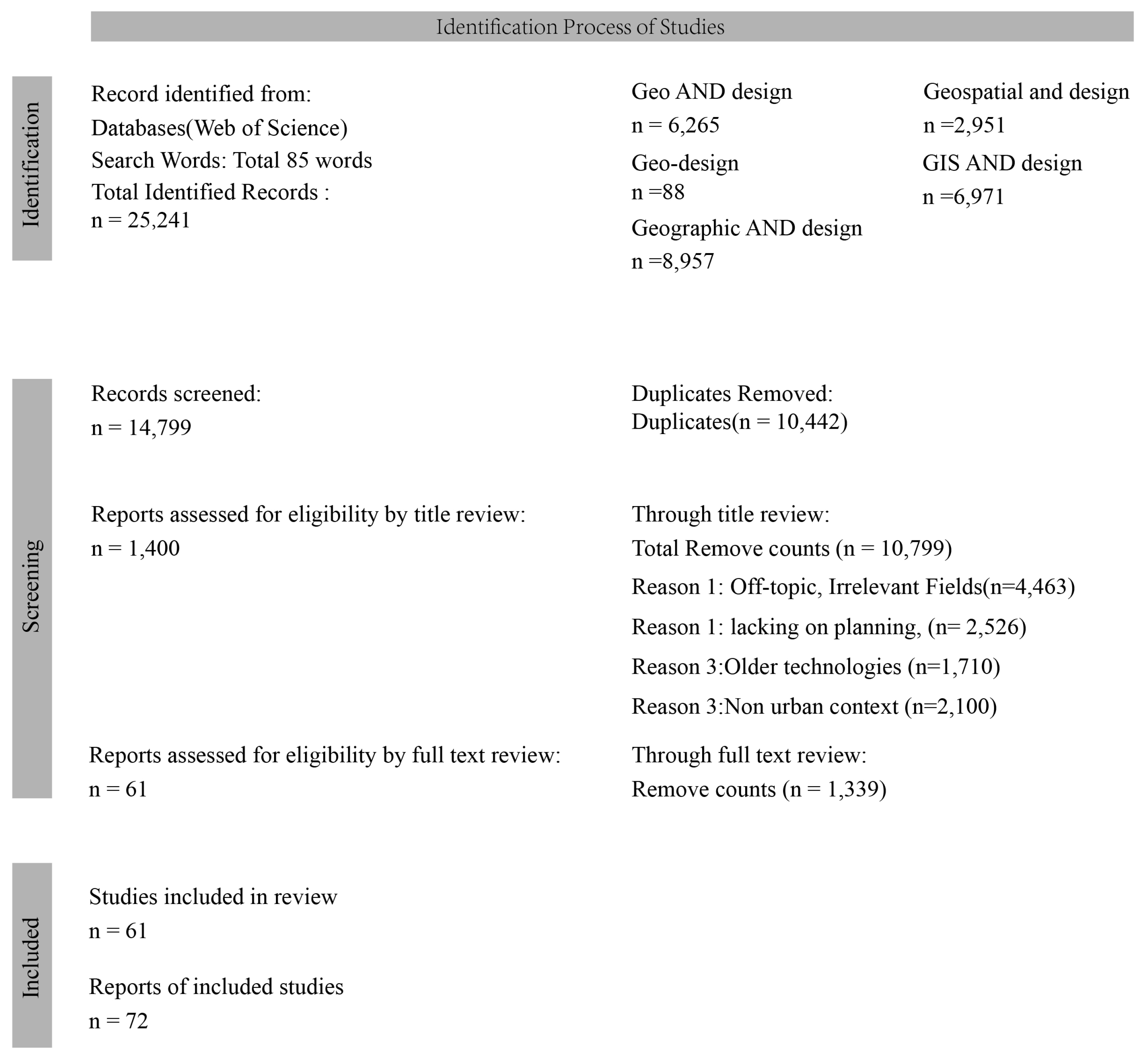
2.1. Search Keywords
2.2. Search Strategy
- The study must be conducted in an urban, outdoor context. Studies in rural areas, forests, or natural river environments are excluded.
- The focus of the study should be on the use of geospatial information in planning and design.
- The study must incorporate state-of-the-art technologies, with a preference for articles published within the last decade to ensure relevance to recent advancements in artificial intelligence.
- The study should fall within the disciplinary categories of planning, landscape, geography, or forestry. Articles dedicated to computer science focusing primarily on algorithms or models are excluded.
2.3. Data Extraction and Synthesis
3. Results
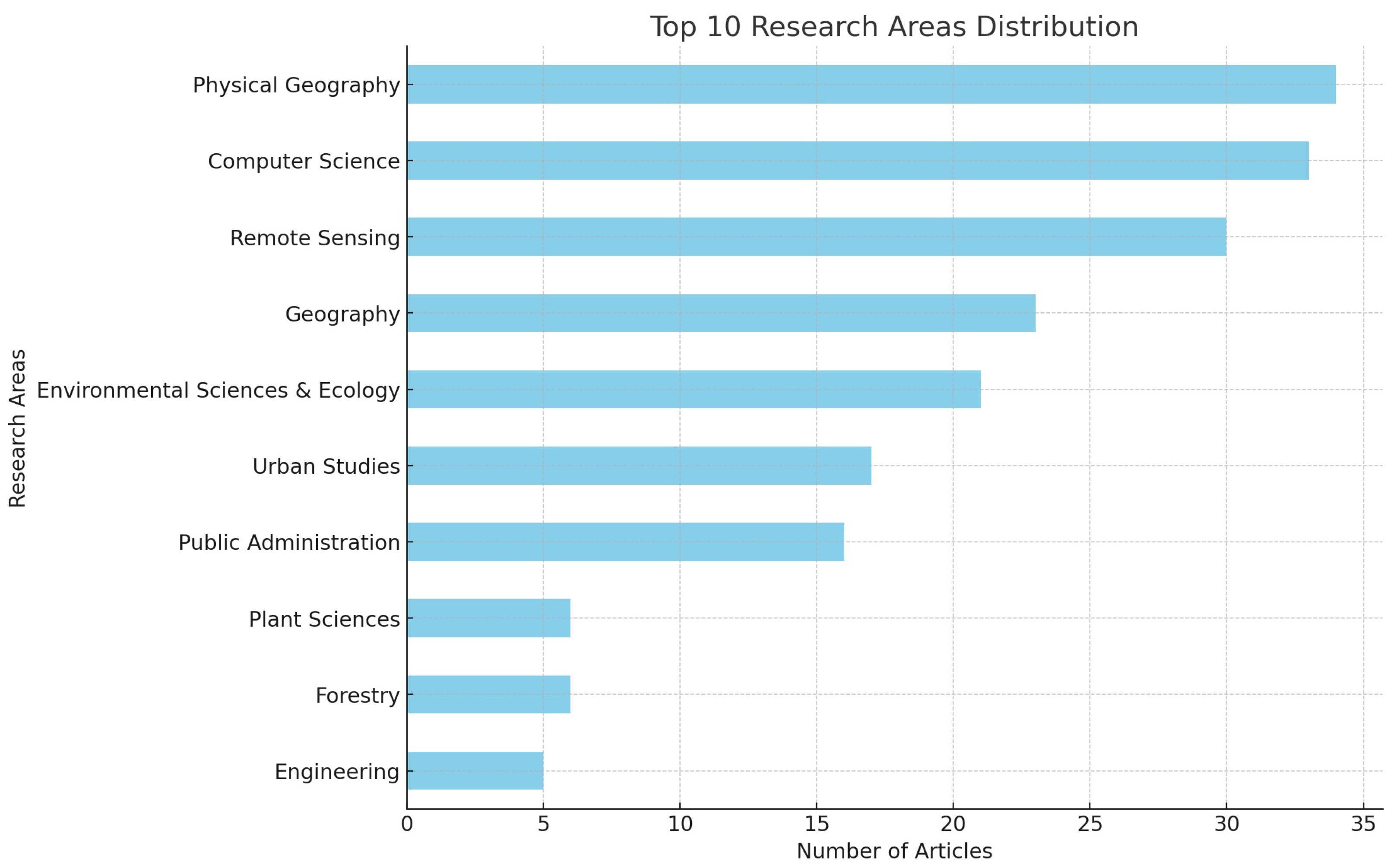
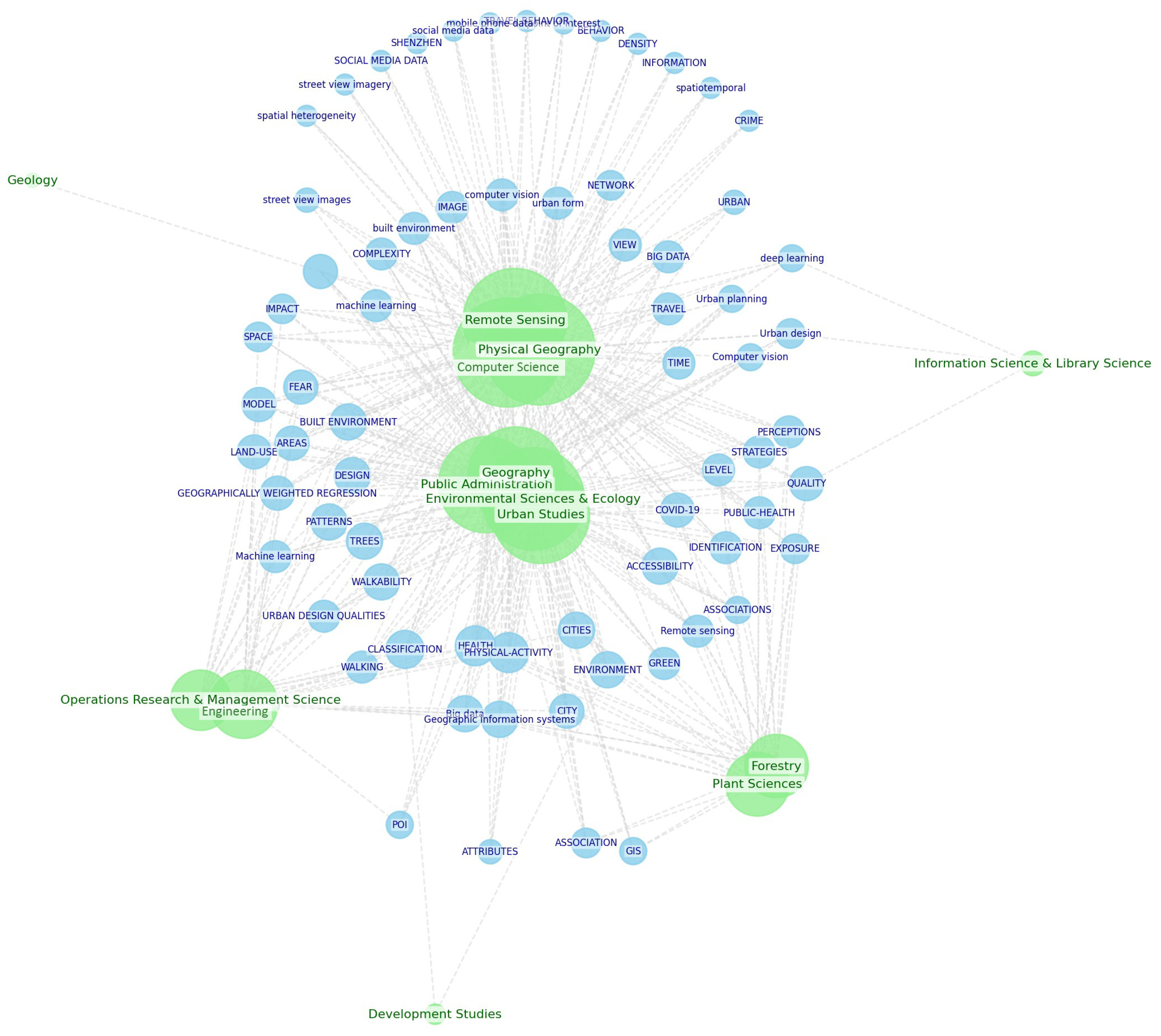
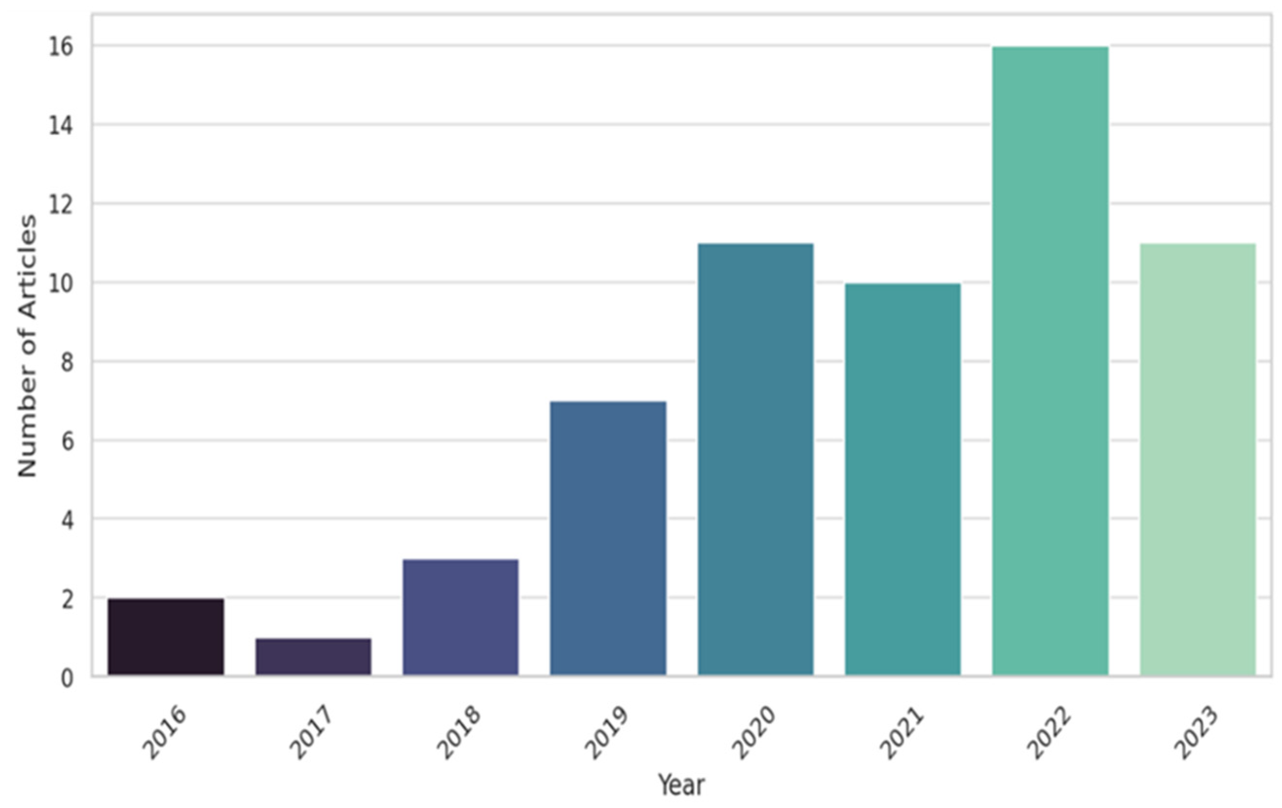
3.1. Research Trend
3.2. Methodological Approaches
3.3. Application Theme
3.3.1. Transportation and Context
3.3.2. Built Environment and Perception
3.3.3. Data-Driven Approach
3.3.4. Urban Region

| Analysis Theme | Category | Description | Citation |
|---|---|---|---|
| Transportation and Context | TOD Planning | Multi-objective optimization design based on nondominated sorting genetic algorithm III | [18] |
| Traffic Flow Analysis | Uses machine learning, including SVM, KNN, PCA, RT, and Faster R-CNN, for vehicle detection. | [21] | |
| The ANST model combines LSTM and attention mechanisms for traffic forecasting. | [24] | ||
| Using spatial context mining and a support vector machine model to identify transport modes from big data. | [20] | ||
| Estimates urban intersection travel times using low-frequency GPS data, analyzing traffic patterns, and applying fuzzy fitting to calculate flow speed and delay. | [19] | ||
| Using LDCF machine learning algorithm to automatically assess pedestrian volumes in urban areas. | [23] | ||
| Transportation Management | Using a two-step method of spatiotemporal pattern extraction and Gaussian modeling for precise urban transport management. | [45] | |
| Combines road network analysis, street view images, and deep learning to efficiently identify signalized intersections. | [46] | ||
| Transportation Safety | This study employs imagery and a deep learning-based model to detect marked crosswalks. | [22] | |
| Transportation Decision and Simulation | Enhances active mobility planning using deep learning DeepLabV3 segmentation trained on a WideResNet-38 model analyzing street imagery. | [25] | |
| Uses big data, pedestrian simulation, and AnyLogic to identify facility gaps and traffic issues. | [26] | ||
| Built Environment and Perception | Human Perception and Activity | Using multi-source big data and data mining to analyze influencing factors to optimize unsafe urban areas. | [47] |
| Uses deep learning and random-forest algorithms to analyze human perceptions of urban spaces. | [48] | ||
| Uses deep learning to explore how urban space characteristics influence people’s emotional responses | [44] | ||
| Analyses urban vitality’s spatial patterns and driving factors using multi-source big data. | [49] | ||
| Analyzes the built environment’s impact on occupational diversity using GeoDetector-based indicators for in-depth analysis. | [1] | ||
| Employs deep learning for image segmentation and NDVI to measure urban greenness. | [50] | ||
| Utilizes a mix of text mining, image processing, clustering, kernel density estimation, and sentiment analysis to assess urban perceptions. | [28] | ||
| Uses multiple linear regressions to analyze three types of urban residents’ activity spaces at multiple geographic scales. | [29] | ||
| Develops an analytical framework using mobile phone data to assess occupational diversity in urban areas. | [51] | ||
| Uses machine learning to predict urban street running intensity. | [52] | ||
| Analyses Dhaka’s travel patterns using household diaries, artificial neural networks, and regression. | [53] | ||
| Evaluating human perceptions of streetscapes using integrating PSPNET, attention mechanisms, and transfer learning. | [54] | ||
| Building Environment Assessment | Develop a framework for assessing urban street quality using the DeepLabv3 model. | [31] | |
| Examines the Street commercial pedestrian block characteristics using Isovist_App software simulation and spatial analysis. | [55] | ||
| This study employs machine learning and a Fully Convolutional Network (FCN) for image segmentation to improve street quality. | [31] | ||
| Conducts a deep learning-based classification analysis of public space images. | [30] | ||
| Leveraging semantic segmentation and information entropy models for assessing visual perceptual information in urban street spaces. | [56] | ||
| Introduces a deep learning approach to comprehensively analyze the spatial ratios of streets. | [57] | ||
| Employs GIS, deep learning DeepLab-v3 +model, and sensors to assess urban walkability. | [58] | ||
| Examines how street greenery affects older adults’ walking behavior using global (linear regression, Box–Cox) and local (geographically weighted regression) models. | [59] | ||
| Utilizes deep convolutional neural networks to classify urban street frontages. | [60] | ||
| Employs a multiscale analysis method and Multiscale Geographically Weighted Regression (MGWR) to explore the impact of environmental features on crime. | [61] | ||
| Data-Driven Approach | Data Visualization | Develops a task-oriented approach. The method enhances geo-design maps for change analysis by integrating spatial data preprocessing, local extreme value preservation, and context-aware classification techniques. | [32] |
| Introduces a novel 3D-4D interface that combines GIS, geo-located data, high-resolution 3D models, and multimedia for immersive visualization of large space-time datasets in smart cities. | [34] | ||
| Develops a deep learning method with GANs and Single image depth estimation for 3D reconstruction of building façades. | [62] | ||
| Enhancing citizen engagement in urban planning, using dynamic, immersive tools for visualizing city evolution. | [33] | ||
| Geospatial Data Management | Introduces VeST, a novel indexing model for efficient CKNN queries on moving objects in a distributed environment. | [36] | |
| Introduces STR, a multivariate hierarchical regionalization method for uncovering spatiotemporal patterns, focusing on spatial, temporal contiguity, and attribute similarity. | [37] | ||
| Introducing the J-CO framework for analyzing JSON-formatted data sets to improve urban planning in regeneration and mobility. | [35] | ||
| Urban Region | Function Classification | Applied POI data from an online map service and kernel density analysis in various grid sizes to identify urban functional areas. | [38] |
| Develop a machine learning approach with Random Forest, Support Vector Machine, and Naive Bayes algorithms to identify rural residential land. | [63] | ||
| This study introduces and validates the Place2vec model for effectively identifying urban functional regions using Points of Interest (POIs) and K-means clustering. | [39] | ||
| Focuses on classifying building functions in urban areas using deep learning techniques, specifically Graph Convolutional Networks (GCNs). | [40] | ||
| The study introduces a novel deep neural network based on graph convolutions, designed to automatically identify patterns in building groups with arbitrary forms. | [41] | ||
| This study introduces a method to identify and analyze influential urban regions using spatial interaction networks based on human movement data. | [64] | ||
| This research proposes the Spatial Vector Deep Neural Network (SVDNN) model to measure the Multidimensional Poverty Index (MPI). | [65] | ||
| Public Health | Examines the commercial pedestrian block characteristics using Isovist_App software simulation, big data statistics, and spatial. | [42] | |
| Utilizing environmental monitoring, machine learning explores the impact of urban features and environmental factors on physiological stress responses. | [43] | ||
| Uses PPGIS, Deep Learning, and PLS methods to analyze how urban park features and psychological factors affect college students’ perceived restoration. | [44] | ||
| Urban Ecosystem Services | Investigate the relationship between urban spatial patterns and ecosystem services using spatial metrics and the Geographically Weighted Regression (GWR) model. | [66] | |
| Based on remote sensing and spatial analysis, the spatial and temporal changes of green space distribution and spatial and temporal patterns of green space distribution index were analyzed. | [67] | ||
| Bivariate Moran’s I and multiple regression are adopted to explore the equity of urban green space accessibility. | [68] | ||
| This study uses land use regression to assess urban greening’s impact on air pollution. | [69] | ||
| Combines including rainfall simulation, remote sensing analysis, and semantic information analytics to identify flooded roads. | [70] |
4. Discussion
4.1. Methodological Approaches
4.2. Strengths, Limitations, and Implications
4.3. Comparative Analysis
4.4. Future Directions
5. Conclusions
Author Contributions
Funding
Data Availability Statement
Conflicts of Interest
References
- Deng, X.; Liu, Y.; Gao, F.; Liao, S.; Zhou, F.; Cai, G. Spatial Distribution and Mechanism of Urban Occupation Mixture in Guangzhou: An Optimized GeoDetector-Based Index to Compare Individual and Interactive Effects. ISPRS Int. J. Geo-Inf. 2021, 10, 659. [Google Scholar] [CrossRef]
- Baschak, L.A.; Brown, R.D. An Ecological Framework for the Planning, Design and Management of Urban River Greenways. Landsc. Urban Plan. 1995, 33, 211–225. [Google Scholar] [CrossRef]
- Nishant, R.; Kennedy, M.; Corbett, J. Artificial Intelligence for Sustainability: Challenges, Opportunities, and a Research Agenda. Int. J. Inf. Manag. 2020, 53, 102104. [Google Scholar] [CrossRef]
- Beheshti, A.; Benatallah, B.; Tabebordbar, A.; Motahari-Nezhad, H.R.; Barukh, M.C.; Nouri, R. Datasynapse: A social data curation foundry. Distrib. Parallel Databases 2019, 37, 351–384. [Google Scholar] [CrossRef]
- Tory, M.; Bartram, L.; Fiore-Gartland, B.; Crisan, A. Finding Their Data Voice: Practices and Challenges of Dashboard Users. IEEE Comput. Graph. Appl. 2023, 43, 22–36. [Google Scholar] [CrossRef] [PubMed]
- Bateman, I.J.; Jones, A.P.; Lovett, A.A.; Lake, I.R.; Day, B.H. Applying Geographical Information Systems (GIS) to Environmental and Resource Economics. Environ. Resour. Econ. 2002, 22, 219–269. [Google Scholar] [CrossRef]
- Eikelboom, T.; Janssen, R.; Stewart, T. A Spatial Optimization Algorithm for Geodesign. Landsc. Urban Plan. 2015, 144, 10–21. [Google Scholar] [CrossRef]
- Song, Y.; Kalacska, M.; Gašparović, M.; Yao, J.; Najibi, N. Advances in Geocomputation and Geospatial Artificial Intelligence (GeoAI) for Mapping. Int. J. Appl. Earth Obs. Geoinf. 2023, 120, 103300. [Google Scholar] [CrossRef]
- Egerer, M.; Haase, D.; McPhearson, T.; Frantzeskaki, N.; Andersson, E.; Nagendra, H.; Ossola, A. Urban Change as an Untapped Opportunity for Climate Adaptation. Npj Urban Sustain. 2021, 1, 22. [Google Scholar] [CrossRef]
- Batty, M. Big Data, Smart Cities and City Planning. Dialogues Hum. Geogr. 2013, 3, 274–279. [Google Scholar] [CrossRef]
- Zhang, B.; Zhu, J.; Su, H. Toward the Third Generation Artificial Intelligence. Sci. China Inf. Sci. 2023, 66, 121101. [Google Scholar] [CrossRef]
- Zhao, Q. Artificial Intelligence Study: A Two-Sided Being—Teachings from Book of Changes. Adv. Mater. Res. 2013, 694–697, 2295–2298. [Google Scholar] [CrossRef]
- Shi, P.; Ye, T.; Wang, Y.; Zhou, T.; Xu, W.; Du, J.; Wang, J.; Li, N.; Huang, C.; Liu, L.; et al. Disaster Risk Science: A Geographical Perspective and a Research Framework. Int. J. Disaster Risk Sci. 2020, 11, 426–440. [Google Scholar] [CrossRef]
- Arciniegas, G.; Šileryté, R.; Dąbrowski, M.; Wandl, A.; Dukai, B.; Bohnet, M.; Gutsche, J.-M. A Geodesign Decision Support Environment for Integrating Management of Resource Flows in Spatial Planning. Urban Plan. 2019, 4, 32–51. [Google Scholar] [CrossRef]
- Chen, M.; Cai, Y.; Guo, S.; Sun, R.; Yang, S.; Shen, X. Evaluating Implied Urban Nature Vitality in San Francisco: An Interdisciplinary Approach Combining Census Data, Street View Images, and Social Media Analysis. Urban For. Urban Green. 2024, 95, 128289. [Google Scholar] [CrossRef]
- Batty, M. The New Science of Cities; MIT Press: Cambridge, MA, USA, 2013; ISBN 978-0-262-01952-1. [Google Scholar]
- Page, M.J.; McKenzie, J.E.; Bossuyt, P.M.; Boutron, I.; Hoffmann, T.C.; Mulrow, C.D.; Shamseer, L.; Tetzlaff, J.M.; Akl, E.A.; Brennan, S.E.; et al. The PRISMA 2020 Statement: An Updated Guideline for Reporting Systematic Reviews. Br. Med. J. 2021, 372, n71. [Google Scholar] [CrossRef] [PubMed]
- Dong, S.; Wang, Y.; Dou, M.; Gu, Y.; Zhang, P.; Gong, J. A Multiobjective Land Use Design Framework with Geo-Big Data for Station-Level Transit-Oriented Development Planning. ISPRS Int. J. Geo-Inf. 2022, 11, 364. [Google Scholar] [CrossRef]
- Tang, L.; Kan, Z.; Zhang, X.; Yang, X.; Huang, F.; Li, Q. Travel Time Estimation at Intersections Based on Low-Frequency Spatial-Temporal GPS Trajectory Big Data. Cartogr. Geogr. Inf. Sci. 2016, 43, 417–426. [Google Scholar] [CrossRef]
- Semanjski, I.; Gautama, S.; Ahas, R.; Witlox, F. Spatial Context Mining Approach for Transport Mode Recognition from Mobile Sensed Big Data. Comput. Environ. Urban Syst. 2017, 66, 38–52. [Google Scholar] [CrossRef]
- Golej, P.; Horak, J.; Kukuliač, P.; Jurikovska Orlikova, L. Vehicle Detection Using Panchromatic High-Resolution Satellite Images as a Support for Urban Planning. Case Study of Prague’s Centre. GeoScape 2022, 16, 108–119. [Google Scholar] [CrossRef]
- Li, M.; Sheng, H.; Irvin, J.; Chung, H.; Ying, A.; Sun, T.; Ng, A.Y.; Rodriguez, D.A. Marked Crosswalks in US Transit-Oriented Station Areas, 2007–2020: A Computer Vision Approach Using Street View Imagery. Environ. Plan. B Urban Anal. City Sci. 2023, 50, 350–369. [Google Scholar] [CrossRef]
- Chen, L.; Lu, Y.; Sheng, Q.; Ye, Y.; Wang, R.; Liu, Y. Estimating Pedestrian Volume Using Street View Images: A Large-Scale Validation Test. Comput. Environ. Urban Syst. 2020, 81, 101481. [Google Scholar] [CrossRef]
- Nadarajan, J.; Sivanraj, R. Attention-Based Multiscale Spatiotemporal Network for Traffic Forecast with Fusion of External Factors. ISPRS Int. J. Geo-Inf. 2022, 11, 619. [Google Scholar] [CrossRef]
- Yap, W.; Chang, J.-H.; Biljecki, F. Incorporating Networks in Semantic Understanding of Streetscapes: Contextualising Active Mobility Decisions. Environ. Plan. B Urban Anal. City Sci. 2023, 50, 1416–1437. [Google Scholar] [CrossRef]
- Chen, Y.; Yang, J. Historic Neighborhood Design Based on Facility Heatmap and Pedestrian Simulation: Case Study in China. J. Urban Plan. Dev. 2020, 146, 04020001. [Google Scholar] [CrossRef]
- Li, X.; Hijazi, I.; Koenig, R.; Lv, Z.; Zhong, C.; Schmitt, G. Assessing Essential Qualities of Urban Space with Emotional and Visual Data Based on GIS Technique. ISPRS Int. J. Geo-Inf. 2016, 5, 218. [Google Scholar] [CrossRef]
- Huang, J.; Obracht-Prondzynska, H.; Kamrowska-Zaluska, D.; Sun, Y.; Li, L. The Image of the City on Social Media: A Comparative Study Using “Big Data” and “Small Data” Methods in the Tri-City Region in Poland. Landsc. Urban Plan. 2021, 206, 103977. [Google Scholar] [CrossRef]
- Gong, L.; Jin, M.; Liu, Q.; Gong, Y.; Liu, Y. Identifying Urban Residents’ Activity Space at Multiple Geographic Scales Using Mobile Phone Data. ISPRS Int. J. Geo-Inf. 2020, 9, 241. [Google Scholar] [CrossRef]
- Yang, C.; Liu, T.; Zhang, S. Using Flickr Data to Understand Image of Urban Public Spaces with a Deep Learning Model: A Case Study of the Haihe River in Tianjin. ISPRS Int. J. Geo-Inf. 2022, 11, 497. [Google Scholar] [CrossRef]
- Wang, J.; Hu, Y.; Duolihong, W. Diagnosis and Planning Strategies for Quality of Urban Street Space Based on Street View Images. ISPRS Int. J. Geo-Inf. 2023, 12, 15. [Google Scholar] [CrossRef]
- Schiewe, J. Task-Oriented Visualization Approaches for Landscape and Urban Change Analysis. ISPRS Int. J. Geo-Inf. 2018, 7, 288. [Google Scholar] [CrossRef]
- Lafrance, F.; Daniel, S.; Dragićević, S. Multidimensional Web GIS Approach for Citizen Participation on Urban Evolution. ISPRS Int. J. Geo-Inf. 2019, 8, 253. [Google Scholar] [CrossRef]
- Benita, F.; Perhac, J.; Tunçer, B.; Burkhard, R.; Schubiger, S. 3D-4D Visualisation of IoT Data from Singapore’s National Science Experiment. J. Spat. Sci. 2022, 67, 157–175. [Google Scholar] [CrossRef]
- Burini, F.; Ciriello, D.E.; Ghisalberti, A.; Psaila, G. The Urban Nexus Project: When Urban Mobility Analysis, VGI and Data Science Meet Together. In Mobile Information Systems Leveraging Volunteered Geographic Information for Earth Observation; Bordogna, G., Carrara, P., Eds.; Earth Systems Data and Models; Springer International Publishing: Cham, Switzerland, 2018; pp. 111–130. ISBN 978-3-319-70878-2. [Google Scholar]
- Bareche, I.; Xia, Y. A Distributed Hybrid Indexing for Continuous KNN Query Processing over Moving Objects. ISPRS Int. J. Geo-Inf. 2022, 11, 264. [Google Scholar] [CrossRef]
- Wang, H.; Zhang, H.; Zhu, H.; Zhao, F.; Jiang, S.; Tang, G.; Xiong, L. A Multivariate Hierarchical Regionalization Method to Discovering Spatiotemporal Patterns. GIScience Remote Sens. 2023, 60, 2176704. [Google Scholar] [CrossRef]
- Luo, S.; Liu, Y.; Du, M.; Gao, S.; Wang, P.; Liu, X. The Influence of Spatial Grid Division on the Layout Analysis of Urban Functional Areas. ISPRS Int. J. Geo-Inf. 2021, 10, 189. [Google Scholar] [CrossRef]
- Zhai, W.; Bai, X.; Shi, Y.; Han, Y.; Peng, Z.-R.; Gu, C. Beyond Word2vec: An Approach for Urban Functional Region Extraction and Identification by Combining Place2vec and POIs. Comput. Environ. Urban Syst. 2019, 74, 1–12. [Google Scholar] [CrossRef]
- Xu, Y.; He, Z.; Xie, X.; Xie, Z.; Luo, J.; Xie, H. Building Function Classification in Nanjing, China, Using Deep Learning. Trans. GIS 2022, 26, 2145–2165. [Google Scholar] [CrossRef]
- Zhao, R.; Ai, T.; Yu, W.; He, Y.; Shen, Y. Recognition of Building Group Patterns Using Graph Convolutional Network. Cartogr. Geogr. Inf. Sci. 2020, 47, 400–417. [Google Scholar] [CrossRef]
- Peng, Z.; Wang, R.; Liu, L.; Wu, H. Exploring Urban Spatial Features of COVID-19 Transmission in Wuhan Based on Social Media Data. ISPRS Int. J. Geo-Inf. 2020, 9, 402. [Google Scholar] [CrossRef]
- Benita, F.; Tunçer, B. Exploring the Effect of Urban Features and Immediate Environment on Body Responses. Urban For. Urban Green. 2019, 43, 126365. [Google Scholar] [CrossRef]
- Li, X.; Zhang, X.; Jia, T. Humanization of Nature: Testing the Influences of Urban Park Characteristics and Psychological Factors on Collegers’ Perceived Restoration. Urban For. Urban Green. 2023, 79, 127806. [Google Scholar] [CrossRef]
- Cheng, L.; Yang, X.; Tang, L.; Duan, Q.; Kan, Z.; Zhang, X.; Ye, X. Spatiotemporal Analysis of Taxi-Driver Shifts Using Big Trace Data. ISPRS Int. J. Geo-Inf. 2020, 9, 281. [Google Scholar] [CrossRef]
- Li, X.; Ning, H.; Huang, X.; Dadashova, B.; Kang, Y.; Ma, A. Urban Infrastructure Audit: An Effective Protocol to Digitize Signalized Intersections by Mining Street View Images. Cartogr. Geogr. Inf. Sci. 2022, 49, 32–49. [Google Scholar] [CrossRef]
- Wu, W.; Guo, J.; Ma, Z.; Zhao, K. Data-Driven Approach to Assess Street Safety: Large-Scale Analysis of the Microscopic Design. ISPRS Int. J. Geo-Inf. 2022, 11, 537. [Google Scholar] [CrossRef]
- Ji, H.; Qing, L.; Han, L.; Wang, Z.; Cheng, Y.; Peng, Y. A New Data-Enabled Intelligence Framework for Evaluating Urban Space Perception. ISPRS Int. J. Geo-Inf. 2021, 10, 400. [Google Scholar] [CrossRef]
- Liu, S.; Zhang, L.; Long, Y.; Long, Y.; Xu, M. A New Urban Vitality Analysis and Evaluation Framework Based on Human Activity Modeling Using Multi-Source Big Data. ISPRS Int. J. Geo-Inf. 2020, 9, 617. [Google Scholar] [CrossRef]
- Gao, F.; Li, S.; Tan, Z.; Zhang, X.; Lai, Z.; Tan, Z. How Is Urban Greenness Spatially Associated with Dockless Bike Sharing Usage on Weekdays, Weekends, and Holidays? ISPRS Int. J. Geo-Inf. 2021, 10, 238. [Google Scholar] [CrossRef]
- Zhang, X.; Gao, F.; Liao, S.; Zhou, F.; Cai, G.; Li, S. Portraying Citizens’ Occupations and Assessing Urban Occupation Mixture with Mobile Phone Data: A Novel Spatiotemporal Analytical Framework. ISPRS Int. J. Geo-Inf. 2021, 10, 392. [Google Scholar] [CrossRef]
- Zhang, S.; Liu, N.; Ma, B.; Yan, S. The Effects of Street Environment Features on Road Running: An Analysis Using Crowdsourced Fitness Tracker Data and Machine Learning. Environ. Plan. B Urban Anal. City Sci. 2023, 51, 529–545. [Google Scholar] [CrossRef]
- Sharmeen, N.; Houston, D. Urban Form, Socio-Demographics, Attitude and Activity Spaces: Using Household-Based Travel Diary Approach to Understand Travel and Activity Space Behaviors. Urban Sci. 2020, 4, 69. [Google Scholar] [CrossRef]
- Li, Y.; Zhang, C.; Wang, C.; Cheng, Z. Human Perception Evaluation System for Urban Streetscapes Based on Computer Vision Algorithms with Attention Mechanisms. Trans. GIS 2022, 26, 2440–2454. [Google Scholar] [CrossRef]
- Sun, Y.; Lu, W.; Gu, Z. Analysis of Spatial Form and Structure of Commercial Pedestrian Blocks Based on Isovist and Big Data. Environ. Plan. B Urban Anal. City Sci. 2023, 50, 1313–1327. [Google Scholar] [CrossRef]
- Liu, Z.; Ma, X.; Hu, L.; Lu, S.; Ye, X.; You, S.; Tan, Z.; Li, X. Information in Streetscapes—Research on Visual Perception Information Quantity of Street Space Based on Information Entropy and Machine Learning. ISPRS Int. J. Geo-Inf. 2022, 11, 628. [Google Scholar] [CrossRef]
- Gao, W.; Hou, J.; Gao, Y.; Zhao, M.; Jia, M. Quantifying the Spatial Ratio of Streets in Beijing Based on Street-View Images. ISPRS Int. J. Geo-Inf. 2023, 12, 246. [Google Scholar] [CrossRef]
- Li, Y.; Yabuki, N.; Fukuda, T. Integrating GIS, Deep Learning, and Environmental Sensors for Multicriteria Evaluation of Urban Street Walkability. Landsc. Urban Plan. 2023, 230, 104603. [Google Scholar] [CrossRef]
- Yang, L.; Liu, J.; Liang, Y.; Lu, Y.; Yang, H. Spatially Varying Effects of Street Greenery on Walking Time of Older Adults. ISPRS Int. J. Geo-Inf. 2021, 10, 596. [Google Scholar] [CrossRef]
- Law, S.; Seresinhe, C.I.; Shen, Y.; Gutierrez-Roig, M. Street-Frontage-Net: Urban Image Classification Using Deep Convolutional Neural Networks. Int. J. Geogr. Inf. Sci. 2020, 34, 681–707. [Google Scholar] [CrossRef]
- He, Z.; Wang, Z.; Xie, Z.; Wu, L.; Chen, Z. Multiscale Analysis of the Influence of Street Built Environment on Crime Occurrence Using Street-View Images. Comput. Environ. Urban Syst. 2022, 97, 101865. [Google Scholar] [CrossRef]
- Bacharidis, K.; Sarri, F.; Ragia, L. 3D Building Façade Reconstruction Using Deep Learning. ISPRS Int. J. Geo-Inf. 2020, 9, 322. [Google Scholar] [CrossRef]
- Xu, F.; Ho, H.C.; Chi, G.; Wang, Z. Abandoned Rural Residential Land: Using Machine Learning Techniques to Identify Rural Residential Land Vulnerable to Be Abandoned in Mountainous Areas. Habitat Int. 2019, 84, 43–56. [Google Scholar] [CrossRef]
- Jia, T.; Yu, X.; Li, X.; Qin, K. Identification and Analysis of Urban Influential Regions Using Spatial Interaction Networks. Trans. GIS 2021, 25, 2821–2839. [Google Scholar] [CrossRef]
- Zhou, Q.; Chen, N.; Lin, S. A Poverty Measurement Method Incorporating Spatial Correlation: A Case Study in Yangtze River Economic Belt, China. ISPRS Int. J. Geo-Inf. 2022, 11, 50. [Google Scholar] [CrossRef]
- Li, C.; Zhao, J. Investigating the Spatiotemporally Varying Correlation between Urban Spatial Patterns and Ecosystem Services: A Case Study of Nansihu Lake Basin, China. ISPRS Int. J. Geo-Inf. 2019, 8, 346. [Google Scholar] [CrossRef]
- Sathyakumar, V.; Ramsankaran, R.; Bardhan, R. Geospatial Approach for Assessing Spatiotemporal Dynamics of Urban Green Space Distribution among Neighbourhoods: A Demonstration in Mumbai. Urban For. Urban Green. 2020, 48, 126585. [Google Scholar] [CrossRef]
- Wen, Z.; Zhang, S.; Yang, Y.; Zheng, X.; Song, Z.; Zhou, Y.; Hao, J. How Does Enclosed Private Residential Green Space Impact Accessibility Equity in Urban Regions? A Case Study in Shenzhen, China. Urban For. Urban Green. 2023, 85, 127968. [Google Scholar] [CrossRef]
- Guo, Y.; Su, J.G.; Dong, Y.; Wolch, J. Application of Land Use Regression Techniques for Urban Greening: An Analysis of Tianjin, China. Urban For. Urban Green. 2019, 38, 11–21. [Google Scholar] [CrossRef]
- She, S.; Zhong, H.; Fang, Z.; Zheng, M.; Zhou, Y. Extracting Flooded Roads by Fusing GPS Trajectories and Road Network. ISPRS Int. J. Geo-Inf. 2019, 8, 407. [Google Scholar] [CrossRef]
- Yao, Y.; Lu, Y.; Guan, Q.; Wang, R. Can Parkland Mitigate Mental Health Burden Imposed by the COVID-19? A National Study in China. Urban For. Urban Green. 2022, 67, 127451. [Google Scholar] [CrossRef]
- Zhang, W.; Zhu, J.; Zhao, P. Comparing World City Networks by Language: A Complex-Network Approach. ISPRS Int. J. Geo-Inf. 2021, 10, 219. [Google Scholar] [CrossRef]
- Turhan, C.; Özbey, M.F.; Çeter, A.E.; Akkurt, G.G. A Novel Data-Driven Model for the Effect of Mood State on Thermal Sensation. Buildings 2023, 13, 1662. [Google Scholar] [CrossRef]


| 2016 | 2017 | 2018 |
| 2 | 1 | 3 |
| (3.28%) | (1.64%) | (4.92%) |
| 2019 | 2020 | 2021 |
| 7 | 11 | 10 |
| (11.48%) | (18.03%) | (16.39%) |
| 2022 | 2023 | total |
| 16 | 11 | 61 |
| (26.23%) | (18.03%) | 100% |
| Data Type | Crowdsourced Data Source |
|---|---|
| Image | Satellite imagery |
| Normalized Difference Vegetation Index (NDVI) data | |
| Street view images | |
| Map data | |
| Spatial Distribution | Land use data |
| Crop production data | |
| Ecosystem services | |
| Soil property data | |
| Point of Interest (POI) | |
| Spatiotemporal | Tracks |
| Road network data | |
| Location coordinates | |
| GPS Location data | |
| Numeric | Socioeconomic data |
| Population numbers | |
| Mobile Phone Data | |
| Building and housing data | |
| Data for ridership | |
| Social media data | Crowdsourced data |
| Emotion and empirical data | Emotion and empirical data |
Disclaimer/Publisher’s Note: The statements, opinions and data contained in all publications are solely those of the individual author(s) and contributor(s) and not of MDPI and/or the editor(s). MDPI and/or the editor(s) disclaim responsibility for any injury to people or property resulting from any ideas, methods, instructions or products referred to in the content. |
© 2024 by the authors. Licensee MDPI, Basel, Switzerland. This article is an open access article distributed under the terms and conditions of the Creative Commons Attribution (CC BY) license (https://creativecommons.org/licenses/by/4.0/).
Share and Cite
He, W.; Chen, M. Advancing Urban Life: A Systematic Review of Emerging Technologies and Artificial Intelligence in Urban Design and Planning. Buildings 2024, 14, 835. https://doi.org/10.3390/buildings14030835
He W, Chen M. Advancing Urban Life: A Systematic Review of Emerging Technologies and Artificial Intelligence in Urban Design and Planning. Buildings. 2024; 14(3):835. https://doi.org/10.3390/buildings14030835
Chicago/Turabian StyleHe, Wei, and Mingze Chen. 2024. "Advancing Urban Life: A Systematic Review of Emerging Technologies and Artificial Intelligence in Urban Design and Planning" Buildings 14, no. 3: 835. https://doi.org/10.3390/buildings14030835