Article

Research on Factors Influencing the Style of Chinese Historic Districts Based on the Mask R-CNN Deep Learning Model

1
School of Civil Engineering, Architecture and Environment, Hubei University of Technology, Wuhan 430068, China
2
Key Laboratory of Intelligent Health Perception and Ecological Restoration of Rivers and Lakes, Ministry of Education, Hubei University of Technology, Wuhan 430068, China
*
Author to whom correspondence should be addressed.
Buildings 2024, 14(2), 420; https://doi.org/10.3390/buildings14020420
Submission received: 20 December 2023 / Revised: 26 January 2024 / Accepted: 30 January 2024 / Published: 3 February 2024

Abstract

:
With the rapid development of Chinese cities, the spatial pattern in historical districts has deteriorated due to a lack of protection measures. Indigenous communities have taken it upon themselves to expand certain spaces around the original residential buildings in order to meet the demands of modern life. However, this expansion has had a negative impact on the stylistic integrity of historical districts, leading to a conflict between cultural heritage and district protection. This study focuses on Tanhualin, a representative historical district in Wuhan. The study divides the district into 10 sub-areas, extracting a total of 4850 street views and selecting 6752 spontaneous spatial samples from them. Utilizing the Mask R-CNN model, the study uses computer-based deep learning to identify, summarize, and categorize the various forms and functions of these spontaneous spaces. The study also analyzes the negative impact of these spaces on the unity of the historical blocks’ interfaces, as well as their positive impact on cultural heritage and the creation of a distinctive atmosphere. Finally, the study proposes reconstruction and renewal strategies from both urban design and architectural design perspectives. These strategies aim to improve the quality of life for indigenous communities, establish a sustainable system for preserving historical imprints, protect the cultural atmosphere of historical blocks, and enhance the adaptability of these blocks in modern cities.

1. Introduction

In the context of efficiency-oriented urbanization [1], the balance between rapid urban development and the protection of historic and cultural areas has inevitably become an urban issue. The preservation of buildings in historic and cultural areas leads to a scarcity of available space, which is no longer able to meet the growing space requirements of local residents [2]. With government leadership, the primary areas within historic and cultural districts have undergone rejuvenation through unified planning and transformation [3], creating commercial areas that satisfy the demands of urban development. However, areas with low commercial value inhabited by locals are often overlooked in the transformation process. Since China’s land system is state-owned, people can only expand their living space on a small scale within their own areas [4]. To fulfill their modern living needs and capitalize on their commercial value, locals spontaneously create additional spaces, such as cantilevered stoves and balconies on the sides of buildings, thus forming spontaneous spaces. These spontaneous spaces (Figure 1) have been developed over an extended period, creating a strong sense of vitality and reflecting the unique style and character of the Chinese historic and cultural areas. However, the construction and design of these spontaneous spaces are carried out by locals themselves, without standardized construction or unified design. This situation poses significant safety hazards and impacts the exterior appearance of the buildings and the overall urban form within the districts, thus presenting a conflict between urban development and the preservation of historic and cultural areas. As the renowned Japanese architect Yoshinobu Ashihara showed in “The Aesthetics of Streets”, significant concepts are those of “the first outline of the street” and the “second outline”. The first outline pertains to the buildings themselves, which serve as the foundation for the street’s overall impression. On the other hand, the “second outline” encompasses supplementary features, such as signboards and outdoor spaces attached to the buildings. Functioning as vital gathering points and visually expanding the urban landscape, this “second contour line” acts as a significant showcase for the city’s image and reflects the level of urban management. Consequently, spontaneous spaces highlight the conflict between retaining the cultural ambiance of historical districts, the preservation of historical imprints, and maintenance of the urban image. This necessitates the adoption of targeted strategies to resolve these challenges.
In the mid-20th century, researchers in both the United States [5] and Europe [6,7] began studying spontaneous space in cities. They explored the advantages and disadvantages of spontaneous space in urban development and introduced the concept of “informal space”. Later, in the late 19th century, Japan started examining the spontaneous renovation and renewal of historic districts by local inhabitants [8]. This highlighted Japanese people’s urgent need to enhance their quality of life, leading to the formation of groups that actively participated in urban design. This initiative contributed to highlighting the existing gap in spontaneous space research in Asia. During the Conference on Poor Cities in Asia in 1998, UN-Habitat introduced the document “Informal Urban Space”, which established a global research framework for spontaneous space studies. However, due to the unique state ownership of land in China, different from other regions [9], there remains a lack of research on spontaneous space, hindering the adoption of mature theories and strategies from other countries. Currently, research in China concerning spontaneous space is primarily limited to underdeveloped urban areas [10,11]. Historic and cultural districts are yet to be extensively studied, and a comprehensive research system and framework for spontaneous spatial research are lacking. Moreover, existing research methods in China depend heavily on field photo investigations and manual summarization [12,13,14]. These methods require significant manpower for long-term, high-frequency, and large-scale investigations, which pose a risk of omitting crucial data and result in small sample sizes. The proposed strategies are often confined to the investigation area, lacking universality. To address these limitations, this paper utilizes the Mask-RCNN deep learning model to collect information relating to spontaneous space and its characteristics. Early-stage training on a vast district view dataset enables the development of a computer vision instance segmentation model that can identify spontaneous space on architectural interfaces within urban environments [15]. Additionally, the study incorporates commercial district map websites like Baidu and Google to identify and extract spontaneous spatial information and features from the extensive district map dataset within the study area [16].
First and foremost, Mask R-CNN is a deep learning model that has achieved remarkable results in case segmentation tasks [17,18,19]. It has been extensively utilized in various computer vision tasks, such as human pose estimation, medical image analysis, and autonomous driving [20]. However, it remains unexplored in the fields of urban research and historic preservation. This method presents a novel approach that replaces the traditional field investigation method [21], which is characterized by limited manual data, extended duration, low efficiency, and low precision. By incorporating computer vision technology, the method significantly enhances research efficiency and improves data accuracy. Moreover, by leveraging computer vision technology, the study identifies crucial data samples of spontaneous spatial data necessary for research using extensive district view data [22,23,24]. Furthermore, it summarizes the forms and functions of spontaneous spaces within historic and cultural districts, analyzing both the positive and negative impacts they have. Ultimately, this approach promotes the positive impact of spontaneous spaces while mitigating the negative effects, thus enabling the formulation of sustainable renewal and protection strategies from the perspective of spontaneous spaces. This research provides valuable case studies and innovative research methods tailored to the unique characteristics of China. It aims to address the inherent contradiction between cultural heritage and historic district protection, offering practical solutions and suggesting new avenues for future investigations.

2. Characteristics of Tanhualin Historic and Cultural District

Tanhualin historic and cultural district is situated in Wuchang District [15,25], Wuhan City, Hubei Province (Figure 2). As a significant historic and cultural district in Wuhan City, it embodies the coexistence and mutual influence of various cultures. In addition to western-style buildings dedicated to education and medical care, traditional Chinese religious structures, like Buddhist and Taoist temples, can also be found here. Moreover, there are numerous old residential buildings that provide memories of urban life from the past century. The area still retains its historic and cultural characteristics, as well as the urban life atmosphere that defined old Wuhan. It emanates a rich humanistic ambiance with local distinctiveness. However, with the rapid pace of urbanization and continuous improvement of urban functions in recent years [25], the Tanhualin Historic and Cultural District (Figure 2) underwent renovation and reconstruction in 2004 in line with urban development. Throughout the whole process, commerce served as the core aspect, maintaining the continuity of the main district interface of the historic and cultural districts to a certain extent. Nevertheless, this renovation has negatively impacted the lives and production methods of local residents, leading to the loss of texture, vitality, and life essence of the historic and cultural districts. Furthermore, during the transformation, the affiliated aboriginal areas were overlooked due to their lack of commercial value, turning them into a conflict zone between urban development and the preservation of historic and cultural districts. Most buildings in these areas were constructed in the 1990s [26] and can no longer adequately meet the demands of modern life or leverage their commercial potential. Consequently, the local inhabitants have erected numerous spontaneous spaces [27,28] to meet modern requirements and to realize commercial value. Unfortunately, these constructions are often haphazard, damaging the overall style and texture of the entire historic and cultural district, despite possessing a sense of era memory, regional vitality [29], and humanistic characteristics [30,31].
Tanhualin historic and cultural district currently faces several challenges that hinder its balanced development:
  • There is an imbalance between urban renewal and historic and cultural. While the main Tanhualin historic and cultural district has been modernized and commercialized in line with the city’s development, the classical buildings, such as religious buildings, villas, educational buildings, residential buildings, and public buildings, which have a rich history of hundreds of years, are all situated in the living areas of aborigines. This has resulted in these living areas lagging behind in modernization, leading to an imbalance in the overall development of the district [32]. Consequently, the modern living and commercial needs of aborigines cannot be adequately met [33].
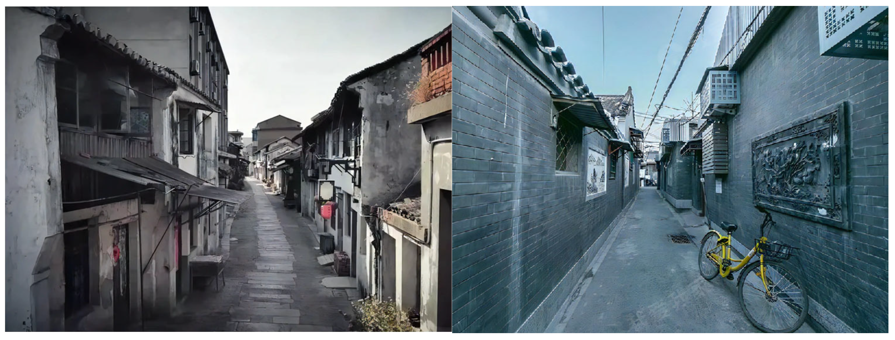
  • The interface of the district is disorganized and lacks unified planning. The buildings in the aboriginal areas are of poor quality, lack versatility in terms of function, and have limited space (Figure 3). The districts are narrow and disorderly, the district density is high, and there is a lack of proper management [34]. These buildings can no longer cater to the needs of modern life or realize their commercial value. As a result, residents have resorted to expanding their living spaces onto the building facades, disrupting the unity of the historic and cultural districts, and causing the environment to become increasingly disorganized.
  • The infrastructure in the area is outdated. The preserved Tanhualin historic and cultural district suffers from a lack of space due to its protected status [35]. The houses are low and densely built, resulting in poor indoor lighting. Residents have to share kitchens and bathrooms, and there is a lack of green space and public activity areas. The public infrastructure is outdated and unable to meet the demands of the present time. In order to improve their living conditions, aborigines choose to extend their living spaces outward, encroaching on district space through spontaneous expansions on building facades. Moreover, the district is riddled with exposed messy wires, which pose a significant fire hazard. These unfavorable factors have hindered the aborigines’ ability to meet the needs of modern living and attain commercial value. Figure 3 displays the model’s output of a representative Tanhualin street scene, derived from a dataset of 6752 filtered samples, upon inputting “crowded space” as keywords (Figure 3).

3. Research Contents and Methods

3.1. Spontaneous Spatial Principle Embodying the Vitality of District Cultural Imprint

Spontaneous space [33] refers to the space created and transformed by users spontaneously in an urban environment. The “spontaneity” of these spaces is not limited and is determined by the users’ self-organization and development. The attributes and volume of these spaces are random [34], which also makes the spontaneous spaces rich in forms and functions. Spontaneous space usually has two characteristics: supplementing life function and realizing commercial value, which is a unique true portrayal of Chinese local social activities [33,35], reflecting local infrastructure construction and residents’ living standards, and embodying unique district texture in specific areas [36]. In addition, the spontaneous spaces created within historic and cultural districts by indigenous communities possess not just profound vitality and a lasting historic influence resulting from extensive historic and cultural experiences, but also serve as the embodiment and representation of the cultural influence and vibrancy exhibited within the districts.

3.2. Research Contents

By collecting and organizing relevant data and examples of existing urban contradictions and historic and cultural districts [37,38,39], this study establishes a preliminary theoretical framework for the protection and development of historic and cultural districts in cities [40]. The focus of this paper is the examination of spontaneous space, which emerges as a result of the contradiction between urban development and the preservation of historic and cultural districts. The paper explores how to address this contradiction from the perspective of spontaneous space, in order to achieve a balanced approach to development and preservation within cities. Taking the current situation of the Tanhualin historic and cultural district into consideration, this study involves the following aspects:
  • Summarizing the form and function of spontaneous space within districts.
  • Investigating and analyzing the reasons behind the emergence of spontaneous space.
  • Studying and analyzing the impact of spontaneous space on both attached and surrounding buildings within districts.
  • Based on the notion of spontaneous space, proposal of sustainable strategies to address the conflict between cultural heritage and the preservation of historic districts.

3.3. Research Methods

To enhance the accuracy and relevance of the data, we selected the main commercial district of Tanhualin, its residential area on the north side and the area encompassing Desheng Bridge in the west, the Alternate District in the south, and Rouge Road in the east as our research scope (Figure 4). To avoid data duplication, we divided the dataset into 10 sub-regions (a–j) based on the form, function, and reasons for spontaneity within the space. These sub-regions served as the detailed sources for our district scape map. Among these areas, we discovered a total of 5784 district views featuring spontaneous space. However, some of the images lacked reference values due to limited pixel resolution. After filtering out the irrelevant images, we obtained 4850 valid district views from which we identified a total of 6752 instances of spontaneous space. After sorting the data, a total of 6752 spontaneous spaces were categorized into three groups based on their usage functions: 1. Spontaneous spaces meant for living assistance; 2. Spontaneous spaces designed for daily use; and 3. Spontaneous spaces intended for commercial purposes. These categories consist of eight specific forms: 1. canopy; 2. air conditioner outdoor unit; 3. peripheral anti-theft net; 4. cantilevered balcony; 5. cantilevered balcony; 6. renaissance clothes hanger; 7. commercial billboard; 8. commercial awning. It should be noted that due to limitations of the trained model, only the spontaneous spaces located on the side interface of the building could be identified. Spontaneous spaces on the bottom interface, such as outdoor activity areas and landscape spaces, could not be detected.

4. Research on Spontaneous Space in Tanhualin Historic and Cultural District

4.1. Early Data Acquisition Based on Mask R-CNN Deep Learning Model

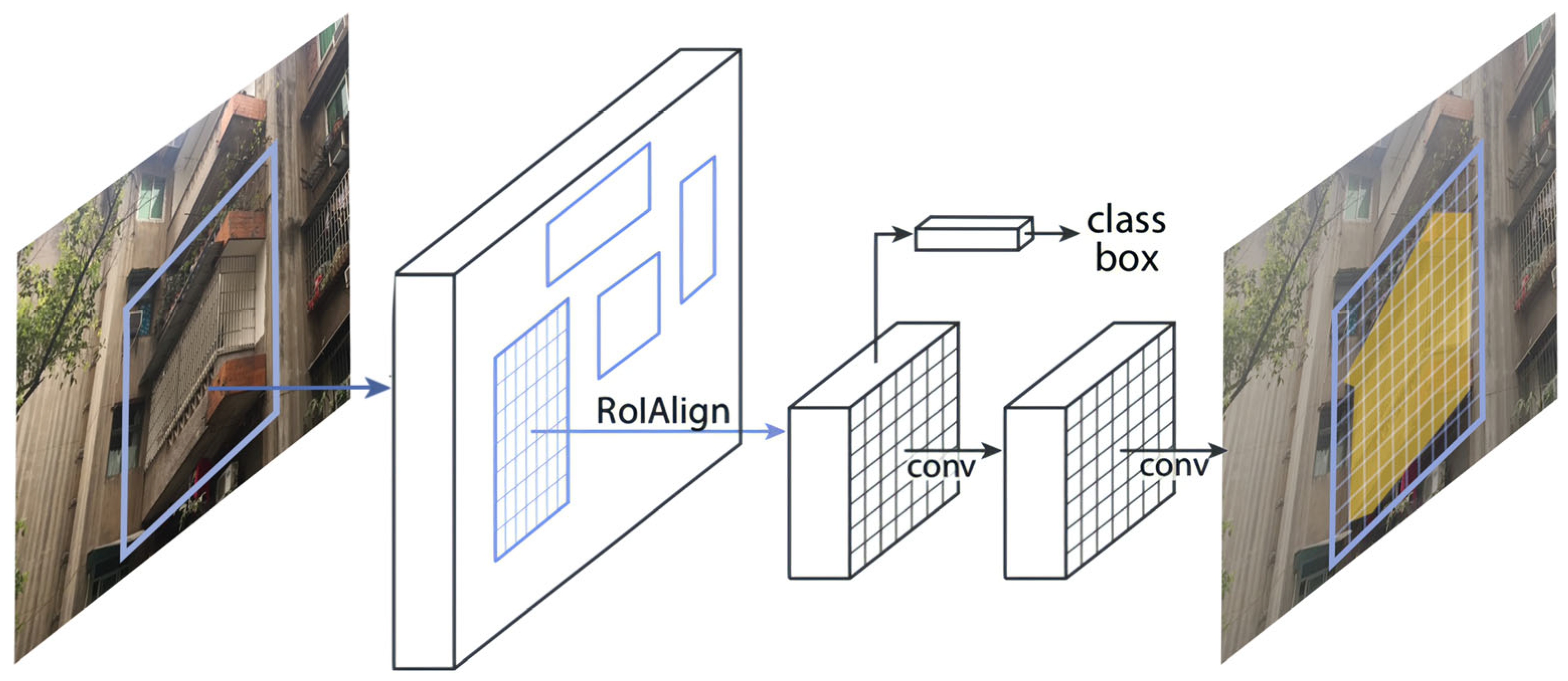
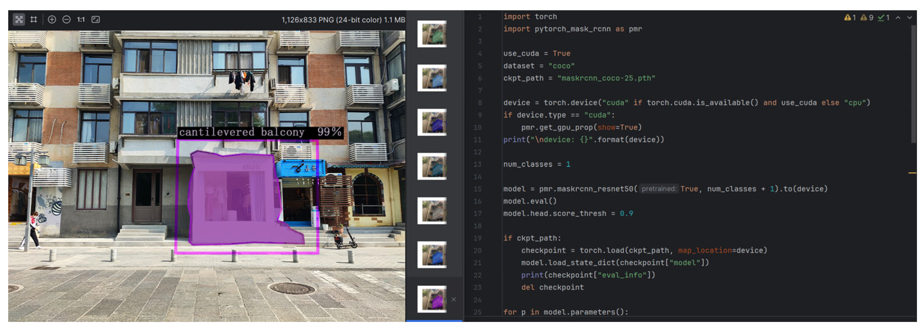
4.1.1. Introduction of Mask-RCNN Deep Learning Model

Mask-RCNN is a deep learning model developed from the regional convolution neural network (RCNN) [41,42]. It generates candidate regions, extracts features, distinguishes feature categories, and corrects candidate box positions. The Mask-RCNN network consists of four main components: (1) basic convolution layer; (2) area generation network (RPN); (3) RoI align; and (4) detection layer. The Mask-RCNN model follows a two-stage framework. In the first stage, the image undergoes scanning to generate candidate frames. In the second stage, classification results and bounding boxes are obtained based on the candidate boxes. Segmentation branches are also added to the original Faster RCNN model [43] in order to obtain mask results, thereby decoupling the relationship between mask and category prediction (Figure 5).

4.1.2. Spontaneous Spatial Data Training Set Based on Massive District View Map

The first step is to create a conda virtual environment, to create an environment named Labelme_env, Python version 3.8, for example: conda create -n labelme_env python = 3.8. After the creation is completed, enter the new environment: conda activate labelme_env. Second, install Labelme and directly use pip to install: pip install labelme pip install pycocotools-windows.
Finally, after the installation is completed, enter “labelme” at the terminal to start: labelme. The labeled image (Figure 6) is input into the neural network as a label for deep learning supervision and classified according to the different forms and functions of spontaneous space. This is used as a training set of spontaneous spatial recognition data based on massive district view maps.

4.1.3. Recognition of Spontaneous Space by Mask R-CNN Deep Learning Model

The steps for identifying spontaneous space using the Mask R-CNN deep learning model are outlined as follows:
  • Develop a Mask R-CNN model and make necessary modifications to the classifier and mask wharf.
  • Set up data loaders and optimizers.
  • Execute the data loader and carry out forward propagation, loss calculation, back propagation, and optimization for each batch.
Ultimately, by integrating the data from Google and Baidu District View, deep learning and computer vision techniques are utilized to classify and identify spontaneous space within the study area (Figure 7). This enables efficient collection of various forms of spontaneous space and characteristic information within the historic and cultural districts.

4.2. Form, Function, and Formation Reasons of Spontaneous Space in Tanhualin District

The combination of use of the Mask R-CNN deep learning model and Google Maps yielded 4850 valid district views, resulting in the identification of 6752 spontaneous spaces. In the Tanhualin historic and cultural district, these spontaneous spaces can be categorized into three types: life-assisted, life-used, and commercial-used. In terms of spatial form, life-assisted spontaneous spaces comprise canopies and air conditioners. Life-used spontaneous spaces include peripheral anti-theft nets, cantilever stoves, cantilever balconies, and drying racks. Commercial-used spontaneous spaces manifest as commercial billboards and canopies. The respective proportions of each category are illustrated in (Figure 8 left). Additionally, spatial representations of spontaneity and its presence in 10 sub-regions (a–j) within the study area are depicted in chord charts. The outermost arc area represents the overall proportion of all forms in the region, while the innermost sector area represents the proportion of forms in the corresponding sub-region. The innermost area illustrates the correspondent relationship between forms and sub-regions (Figure 8 right).
1.
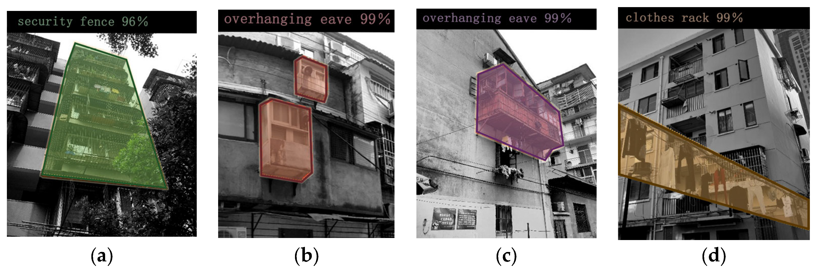
Spontaneous living assisted spaces [44]. This type of spontaneous space is installed on the side interface of the building according to the residents’ own needs, that is, the interface on both sides of the district. The main functions are to provide convenience for daily life and to improve the quality of daily life (Figure 9).
There are two main forms of spontaneous spaces for assisted living (Figure 10): awnings and air-conditioning outdoor units. Awnings are installed above windows or building entrances and exits to form indoor and outdoor buffer spaces and to serve as shelter from wind and rain. There is a certain risk of falling in harsh environments. The installation location of outdoor air conditioners is relatively random, and the installation location is consistent with the location of the indoor air conditioner. They are mainly distributed on both sides and above the window of the building exterior wall and are used in conjunction with the air conditioner internal unit to achieve heat exchange between the indoor and outdoor air.
Reasons for the formation of spontaneous life assistance spaces include the following: The residential buildings in the Tanhualin historic and cultural district were constructed in the last century and lack essential living assistance facilities, such as outdoor canopies. To enhance the residents’ quality of life, they have created spontaneous spaces on the side interfaces of the buildings. Typically, these spontaneous spaces are attached to the building’s side interfaces and are seldom utilized by the occupants after their installation. They typically do not interact with users during use and exist independently on the building’s side interfaces.
2.
Spontaneous space for living use [33]. This type of spontaneous space is an additional living space that extends by itself on the building side interface (interface on both sides of the district) because the indoor space area cannot meet the basic living needs of the residents. The main function is to meet the residents’ basic daily needs, such as storage, drying clothes, and cooking, and to provide support for basic daily life (Figure 11).
Spontaneous spaces for daily use mainly exist in four forms (Figure 12). These include peripheral anti-theft nets, cantilevered stoves, cantilevered balconies, and clothes drying racks. Peripheral anti-theft nets are installed around the window to fully cover the window area, forming an anti-theft function, and improving security. Some residents choose to increase the peripheral width of the anti-theft net to provide more outdoor space to meet storage needs; the cantilevered stove is installed on the side interface above the second floor of the residence in Tanhualin District. The main materials used are thin steel plates and cement plate. The main function is to increase the space of the kitchen and to install smoke exhaust pipes through the space protruding from the side interface of the building to achieve rapid exhaustion of oil fumes. However, the cantilevered stoves in Tanhualin District are all installed by unqualified small workshops, with no safety guarantees and poor wind and earthquake resistance. Cantilevered balconies are mainly installed in areas above the third floor of the building side interface, and the height is consistent with the building floor height. They are mainly connected to the bedroom or living room as an additional space to increase the living area and to meet basic living needs. The clothes’ drying rack is mainly installed in the window of the living room or bedroom to expand the outdoor area and ventilation area to facilitate drying clothes on sunny days and to meet daily living needs.
Reasons for the emergence of spontaneous space in residential use include the following: The residential buildings located in the Tanhualin Historic and Cultural District have a long history. As the population of families residing in these buildings has increased over time, it has become difficult to meet the indoor living requirements in terms of space, lighting, and ventilation. Consequently, the residents have chosen to create additional living space along the side interfaces of the buildings. This allows them to address the insufficiency of residential functionality and to enhance their overall quality of life. In general, this form of spontaneous space is characterized by being connected to the side interfaces of the residential buildings, thus expanding the living area, or serving as an extra living space for the occupants.
3.
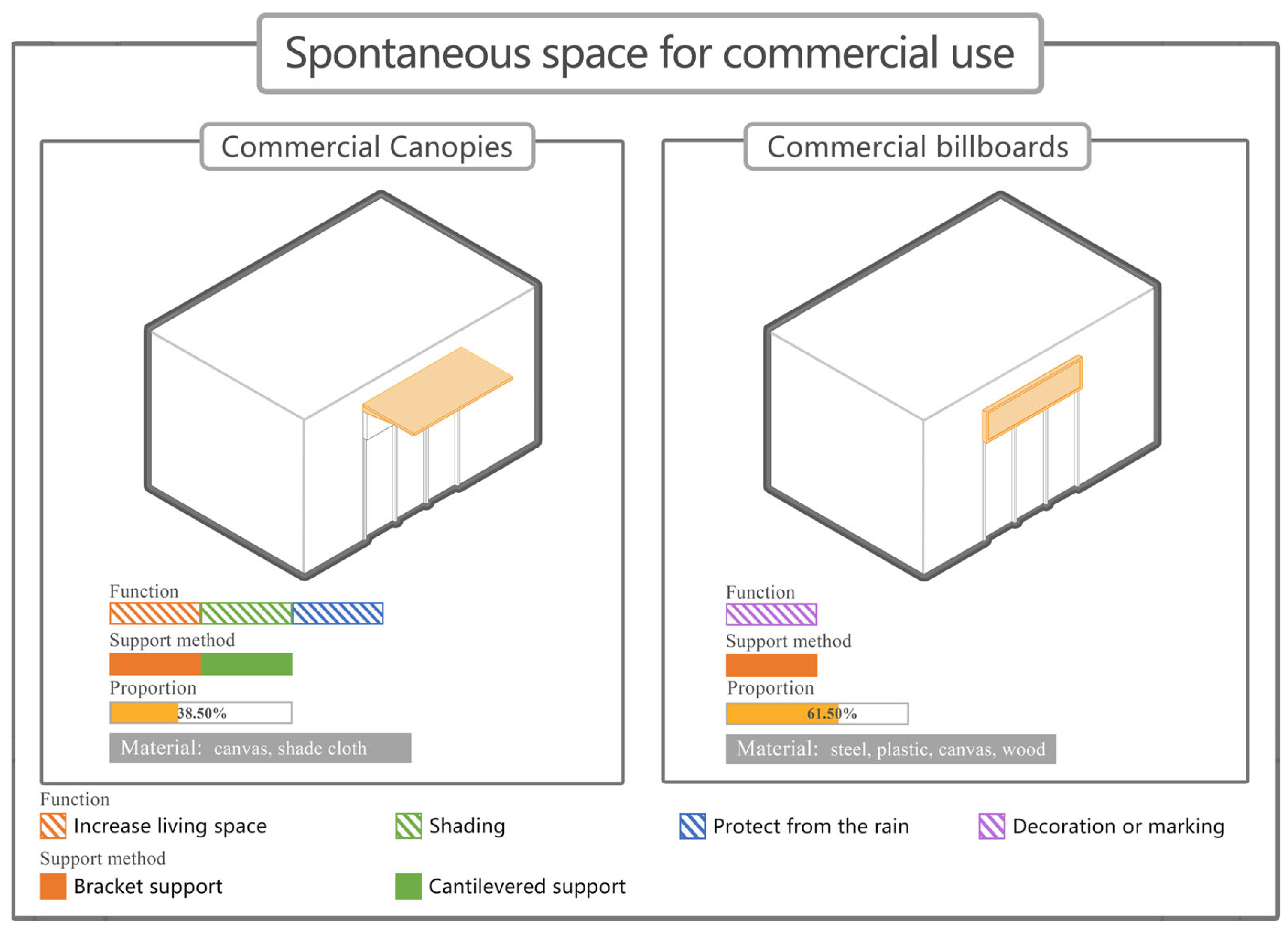
Spontaneous commercial spaces: These types of spontaneous spaces can be found primarily in the commercial area of Tanhualin District. These spaces are created by merchants to expand their business area and enhance its commercial value. Increasing the space also helps attract customers to some extent (Figure 13).
Spontaneous commercial spaces can be categorized into two forms (Figure 14): commercial billboards and commercial canopies (Figure 9). Commercial billboards are carefully designed to showcase the store’s name and overall style and are typically placed above the store entrance. The design, style, and form vary depending on the type of business, ultimately impacting the overall visual harmony of Tanhualin District. Commercial canopies are primarily installed above shop entrances, offering a significant overhang to provide more commercial space and to meet basic wind and rain protection requirements. However, due to the different depths and materials used for each store’s canopies, they take up a certain portion of shared district space [25], affecting the overall coherence of the district and lacking a sense of order.
Reasons for the formation of spontaneous commercial spaces include the following: The formation of spontaneous commercial spaces can be attributed to two main factors: residents seeking to capitalize on the commercial potential of their spaces, and merchants striving to expand their business areas and enhance the economic value of their commercial spaces. In general, these spontaneous spaces primarily consist of ground floor areas in residential buildings within residential areas and commercial districts along the side interfaces of buildings, all designed to unlock their commercial value.

4.3. Influence of Spontaneous Space in Tanhualin District on Original Buildings and Surrounding Historic Buildings

4.3.1. Impact on Original Buildings

On the positive side, the protection of historic and cultural districts has resulted in the original buildings falling behind, while the creation of spontaneous spaces has compensated for the deficiencies in function and form. Moreover, these spontaneous spaces are voluntarily built by users, catering to the diverse needs of different users in terms of spatial attributes and functional divisions [45,46].
From a negative impact perspective, the construction of spontaneous spaces highlights the limits of the original building and impacts the shape and style of its exterior. Additionally, certain types of spontaneous spaces pose significant safety risks due to their age and non-standard construction [33], thereby posing a certain level of threat to the fire safety of the original building.

4.3.2. Impact on the Historic Features of Neighborhood

On the positive side, spontaneous space construction has a long history and can be traced back to the initial formation of historic and cultural districts [47]. This construction style has contributed to preserving the most authentic and local cultural atmosphere and historic imprint within these districts. Despite the passing of time, spontaneous spaces have retained the style and characteristics from the early stages of the formation of historic and cultural districts. This has helped minimize the cultural loss experienced by indigenous people who were forced to relocate due to urban development.
However, negative impacts arise from the disordered and fragmented nature of spontaneous spaces. These spaces lack unified management, which negatively affects the unity of the surrounding historic building interfaces and disrupts the overall functional zoning of the historic and cultural districts.

5. Sustainable Renewal and Protection Strategies for Spontaneous Spaces in Tanhualin Historic and Cultural District

5.1. Sustainable Renewal and Protection Strategies from an Urban Perspective

From an urban design perspective, the spontaneous spatial transformation of the side interface in the Tanhualin Historic and Cultural District should fully respect the local regional characteristics. The existing conditions should be utilized to develop a holistic plan for the entire district side interface [48]. In areas with historic buildings, it is essential to preserve the original structures of the historic and cultural districts. As well as addressing the existing spontaneous spaces on the side surfaces, it is also important to consider appropriate color and style changes to maintain the historic ambiance of the Tanhualin area and reflect local cultural characteristics. To rectify the current disorderly facade management in historic and cultural districts, the following principles for protection and renewal are proposed:
  • Systematic principle [49]. The reconstruction of districts in Tanhualin District should follow systematic principles, with the district government taking the lead and carrying out systematic reconstruction of buildings under the guidance of planning designers and architects. After systematic design, the side interface form of the entire district will remain consistent, ensuring that the district side interface of the buildings are complete, continuous, and unified.
  • Principle of public participation [50,51]. In many historic and cultural district renovation projects in China, participants generally only include the government and professionals, making it difficult for residents to participate in the renovation. In order to ensure that the renewal and reconstruction of the district-side interface is more in line with the needs of users, residents should be involved in the reconstruction decision-making, such as through the organizing of opinion collection meetings and issuing of opinion collection questionnaires. From the perspective of professionals, their participation must be in areas that require professional knowledge or skills, such as frame selection of side interfaces, structural updates, etc. From the perspective of occupants, occupants should be involved in planning and decision-making, such as regarding the choice of style, material, and color for the exterior appearance.
  • The principle of sustainability [52]. With today’s fast-paced and modern lifestyle, people’s material and spiritual needs continue to change with the developments of the time. It is difficult for the functions of residential buildings to meet and adapt to such changes, and it is impossible to rebuild based on user needs. Therefore, sustainable renewal is the preferred method to solve the problem. In the process of planning and renewal, the principle of sustainability should be the leading idea, and a certain amount of free area and transformable space should be left on the district-side interface to support the residents. They can add spontaneous space themselves during subsequent use. In this way, the integrity of the updated district-side interface will not be destroyed, and spontaneous and sustainable updating of the space can be achieved.

5.2. Sustainable Renewal and Protection Strategies from an Architectural Perspective

From an architectural design perspective, the redesign of buildings should be based on the existing spontaneous spaces of the original structure. However, it is crucial that the design process goes beyond mere surface modifications in order to achieve a holistic outcome. To achieve this, it is necessary to address the living needs of local residents and to consider various aspects, such as the style, scale, materials, and installation locations. By doing so, a cohesive building side interface can be created.
To address the renewal and protection of buildings in Tanhualin District, the following strategies are proposed:
1.
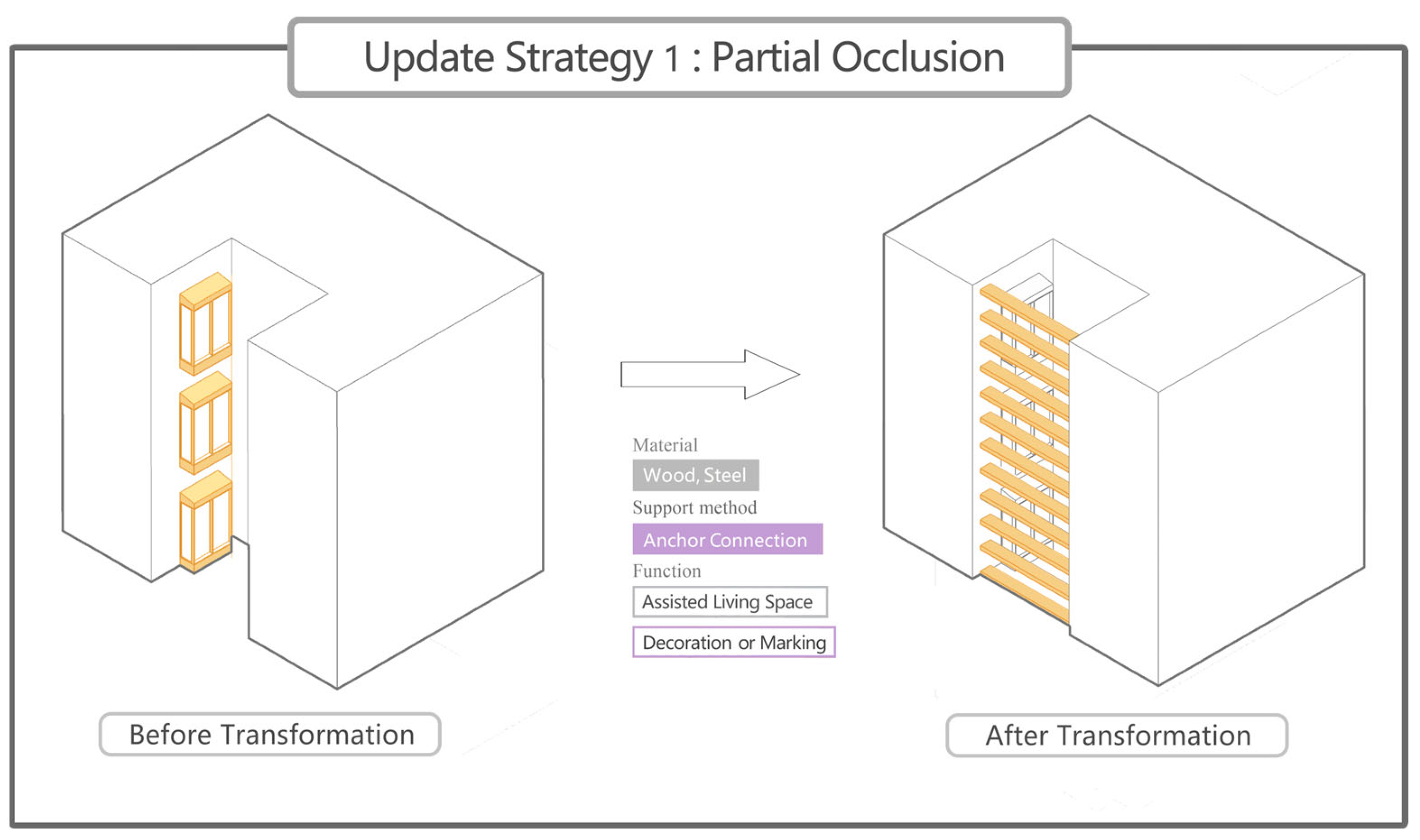
Partial occlusion (Figure 15): In cases where spontaneous spaces are situated at building junctions, such as cantilevered stoves and balconies, a partial shading protection strategy is recommended. Wooden louvers can be used to partially separate areas that impact the building’s exterior and district style. This approach aims to minimize the negative effects of oil fumes generated by the spontaneous spaces and to mitigate style discrepancies with the building’s exterior. Additionally, this strategy maximizes preservation of the historic integrity and liveliness of the original spontaneous spaces.
2.
Adjustment of form and material (Figure 16): In order to address the vacant spaces on the building’s side interface, including anti-theft nets, hanging racks, outdoor units for air conditioning, as well as commercial awnings and billboards, a protection strategy involving form and material adjustment can be employed. To minimize the visual impact on the building interface, the smaller components are replaced with materials that closely match the color of the building’s facade. For larger components, a comprehensive spray-painting method is utilized to align with the facade design and overall aesthetic of the historic and cultural district, ensuring a unified style.
3.
Uniform replacement (Figure 17): In instances where potential safety hazards exist or the above-mentioned protection strategies are insufficient, such as where there are dilapidated air conditioner outdoor units and clothes drying racks, a transformation strategy focused on uniform replacement is necessary. Following the unified design concept of the historic and cultural district’s facade, new equipment can be uniformly purchased to replace the old, worn-out equipment, thus achieving a harmonious and visually appealing interface.

6. Discussion

6.1. Positive Influence

This study clearly demonstrates that spontaneous space is the source of the humanistic atmosphere of historic and cultural districts, prevents indigenous people from being forced to move away during urban development, and is a historic product that reflects the developments of the time. In addition, behind their chaotic and crude appearance, there is also a wisdom of architectural design, regional cultural characteristics, and a regional business internal logic. Finally, this article proposes sustainable renewal and protection strategies based on different perspectives of urban design and architectural design to resolve the contradictions between the protection of historic districts and respecting the lives of indigenous people and cultural heritage, in order to form a sustainable protection system for historic and cultural districts. The research results provide a theoretical basis and suggest new research methods for the implementation of bottom-up renewal and the protection of historic and cultural districts.

6.2. Limitations and Prospects

Chinese cities lack of an efficient public participation system in relation to urban planning and community development efforts [11]. To rectify this, it is advisable for the government to assume responsibility for overseeing the design and construction of impromptu spaces, partnering with designers to guarantee a resident-friendly environment, and enhancing the preservation of historically significant neighborhoods that are imbued with distinct Chinese characteristics. At present, while spontaneous spaces in historic and cultural districts have been analyzed and studied, most of the spontaneous spaces are located on the side interface of buildings, which creates limitations for research. Based on the latest research findings [33,50], architects also advocate the investigation and study of spontaneous spaces located at the foundation of the building. These spaces encompass the outdoor activity area, the landscape zone, as well as the space enclosed by tables and chairs beneath the aboriginal freight shelves. To fully develop a comprehensive theory of spontaneous space in the future, it is imperative to address the inherent conflict between urban development and preservation. Henceforth, it will be crucial to establish a more sophisticated and efficient system that focuses on safeguarding these spontaneous spaces.

7. Conclusions

Based on the Mask R-CNN deep learning model used to identify extensive street scenes, this paper summarizes the functions and forms of spontaneous space in the Tanhualin historical and cultural block in Wuhan. It also reports logical research and influence analysis. On the basis of the research, it is found that the spontaneous space produced by the inhabitants retains the lost vitality and historical characteristics of the historical blocks, making it an indispensable part of creating a historical imprint and cultural atmosphere. However, the formation of spontaneous space also destroys the original architectural interface and the overall form of the historical block, negatively impacting its style.
Therefore, we conducted a statistical analysis of the three functions of spontaneous space: life assistance, life use, and business assistance. We identified eight specific forms of spontaneous space, namely: (1) canopy, (2) external air conditioner, (3) peripheral anti-theft net, (4) cantilever stove, (5) cantilever balcony, (6) drying rack, (7) commercial billboard, and (8) commercial canopy. Our findings reveal that spontaneous space represents a conflict between cultural preservation, historical block protection, and urban development. It is also a crucial element in reviving the vitality of historical and cultural areas. Spontaneous space, being an informal construction without architectural involvement, exhibits various forms and uses various materials while lacking safety measures. Based on the identified eight forms, we propose a rational approach to planning and redesigning spontaneous space within historical blocks. To ensure its safety and rationality, such space should be jointly designed and built by architects and local residents. However, it should be noted that spontaneous space can only serve as an auxiliary type of space to address the conflict between the demands of modern life and the preservation of the indigenous population within historical blocks. Moreover, the renowned Japanese architect Luranraison has introduced the concept of “street aesthetics”, suggesting that the external spaces of buildings constitute the “second contour line” of a street. From this perspective, the quantity, boundaries, and materials used in spontaneous space should be managed uniformly to preserve its aesthetics and integrity. Consequently, based on urban and architectural design principles, we propose six strategies for sustainable protection and renovation as follows: (1) Systematic principle, (2) Principle of public participation, (3) Sustainability principle, (4) Partial occlusion, (5) Form and material adjustment, and (6) Unified replacement. It is suggested that the implementation of these targeted and universal strategies would not only resolve the contradiction between urban development and the preservation of historical blocks but would also retain more historical and cultural elements while bringing new cultural vitality to the blocks. Finally, the research results obtained offer new case examples and technical support with Chinese characteristics for the protection and renewal system of historical blocks. They also provide a Chinese solution to the contradiction between the lives of inhabitants and the preservation of historical blocks.
The current study utilized a Mask R-CNN model, which is a two-dimensional semantic segmentation model for image recognition. In future investigations, it would be beneficial to explore three-dimensional recognition models for the analysis of spontaneous spaces. For instance, the implementation of three-dimensional imaging techniques, like three-dimensional laser scanning or drone oblique photography, could be employed to gather three-dimensional data related to spontaneous spaces. Subsequently, deep learning algorithms could be utilized to develop three-dimensional recognition models and to facilitate learning and recognition processes. By establishing a library of spontaneous spatial information models, this research aims to provide a valuable dataset for future studies.

Author Contributions

Conceptualization, S.L. and W.S.; methodology, S.L. and W.S.; software, S.L. and Z.Y.; formal analysis, S.L.; investigation, S.L., S.B. and Z.Y.; writing—original draft preparation, S.L., W.S. and Z.Y.; writing—review and editing, S.L. and W.S. All authors have read and agreed to the published version of the manuscript.

Funding

This paper was funded by the Key Laboratory of Intelligent Health Perception and Ecological Restoration of Rivers and Lakes, Ministry of Education Hubei University of Technology; Key Project of Scientific Research Plan of Hubei Provincial Department of Education, “Study on the protection and activation of red cultural heritage based on BIM technology”, No: D20221403.

Data Availability Statement

The data presented in this study are available within this article.

Conflicts of Interest

The authors declare no conflicts of interest.

References

  1. Zhang, M.; Zhang, Y.; Fang, X.; Wang, X. A 3D Spatial Diagnostic Framework of Sustainable Historic and Cultural District Preservation: A Case Study in Henan, China. Buildings 2023, 13, 1344. [Google Scholar] [CrossRef]
  2. Li, X.; Joneurairatana, E.; Sirivesmas, V. Paradigm Shift of New Building in Old Urban Districts: Case Study of Bangkok Chinatown Workshop. In E3S Web of Conferences; EDP Sciences: Les Ulis, France, 2021; Volume 236, p. 05059. [Google Scholar] [CrossRef]
  3. Zhou, Y. Urban Street Interface Morphology through Different Times in China. In Quantitative Research on Street Interface Morphology: Comparison between Chinese and Western Cities; Springer Nature: Singapore, 2022; pp. 15–36. [Google Scholar] [CrossRef]
  4. Tang, J.; Long, Y. Measuring visual quality of street space and its temporal variation: Methodology and its application in the Hutong area in Beijing. Landsc. Urban Plan. 2019, 191, 103436. [Google Scholar] [CrossRef]
  5. Jane, J. The Death and Life of Great American Cities; Random House: New York, NY, USA, 1961. [Google Scholar]
  6. Gehl, J. Communication and Public Space. 1996. Available online: https://books.google.com.sg/books?hl=zh-CN&lr=&id=8ct5AgAAQBAJ&oi=fnd&pg=PA3&dq=Gehl,+J.+communication+and+public+space&ots=2LOXoWhka2&sig=loD6_KXAk76xGW8--2ja1iZkND4#v=onepage&q&f=false (accessed on 19 December 2023).
  7. Corbusier, L. Glorious City; China Architecture & Building Press: Beijing, China, 2011; ISBN 9787112121038. Available online: https://book.douban.com/subject/4851826/ (accessed on 19 December 2023).
  8. Yukio, N. Japanese Urban Narrative; Tongji University Publishing House: Shanghai, China, 2013; ISBN 9787576505887. [Google Scholar]
  9. Lin, H.; Zhou, Z.; Chen, S.; Jiang, P. Clustering and assessing carbon peak statuses of typical cities in underdeveloped Western China. Appl. Energy 2023, 329, 120299. [Google Scholar] [CrossRef]
  10. Zhihao, X. Study on the edge space composition of urban living district and the renewal of old city—A case study of the Deshengqiao historic district. In E3S Web of Conferences; EDP Sciences: Les Ulis, France, 2021; Volume 248, p. 03036. [Google Scholar] [CrossRef]
  11. Yang, J.; Wang, L.; Wei, S. Spatial Variation and Its Local Influencing Factors of Intangible Cultural Heritage Development along the Grand Canal in China. Int. J. Environ. Res. Public Health 2022, 20, 662. [Google Scholar] [CrossRef] [PubMed]
  12. Zhang, Y.; Mo, H. Research on Macau’s Historic Buildings Blending Chinese and Western Cultures. In International Civil Engineering and Architecture Conference; Springer Nature: Singapore, 2022; pp. 636–644. [Google Scholar] [CrossRef]
  13. Chan, Y.; Peng, Y. Study on the Conservation and Renewal of Wuhan Tanhualin Historic District. Int. Core J. Eng. 2022, 8, 198–206. [Google Scholar] [CrossRef]
  14. Ding, W.; Chen, H. Urban-rural fringe identification and spatial form transformation during rapid urbanization: A case study in Wuhan, China. Build. Environ. 2022, 226, 109697. [Google Scholar] [CrossRef]
  15. He, K.; Gkioxari, G.; Dollár, P.; Girshick, R. Mask r-cnn. In Proceedings of the IEEE International Conference on Computer Vision, Venice, Italy, 22–29 October 2017; pp. 2961–2969. [Google Scholar]
  16. Bharati, P.; Pramanik, A. Deep learning techniques—R-CNN to mask R-CNN: A survey. Comput. Intell. Pattern Recognit. Proc. CIPR 2020, 2019, 657–668. [Google Scholar]
  17. Chu, P.; Li, Z.; Lammers, K.; Lu, R.; Liu, X. Deep learning-based apple detection using a suppression mask R-CNN. Pattern Recognit. Lett. 2021, 147, 206–211. [Google Scholar] [CrossRef]
  18. Shu, J.H.; Nian, F.D.; Yu, M.H.; Li, X. An improved mask R-CNN model for multiorgan segmentation. Math. Probl. Eng. 2020, 2020, 1–11. [Google Scholar] [CrossRef]
  19. Wei, C.; Gupta, M.; Czerniawski, T. Interoperability between Deep Neural Networks and 3D Architectural Modeling Software: Affordances of Detection and Segmentation. Buildings 2023, 13, 2336. [Google Scholar] [CrossRef]
  20. Bi, X.; Hu, J.; Xiao, B.; Li, W.; Gao, X. IEMask R-CNN: Information-Enhanced Mask R-CNN. IEEE Trans. Big Data 2022, 9, 688–700. [Google Scholar] [CrossRef]
  21. Antrop, M. Sustainable landscapes: Contradiction, fiction or utopia. Landsc. Urban Plan. 2006, 75, 187–197. [Google Scholar] [CrossRef]
  22. Jamal, T.; Stronza, A. Collaboration theory and tourism practice in protected areas: Stakeholders, structuring and sustainability. J. Sustain. Tour. 2009, 17, 169–189. [Google Scholar] [CrossRef]
  23. Zhang, Z.; Wang, X.; Zhu, G.; Zhang, W.; Chen, L.; Fang, K.; Xie, Y.; Shen, M.; Furuya, N. A micro-scale study on the spontaneous spatial improvement of in-between spaces in Chinese traditional districts considering the relationship between modifications and encroachment. J. Asian Archit. Build. Eng. 2023, 22, 783–801. [Google Scholar] [CrossRef]
  24. Nord, C. Architectural space as a moulding factor of care practices and resident privacy in assisted living. Ageing Soc. 2011, 31, 934–952. [Google Scholar] [CrossRef]
  25. Shang, W.; He, C.; Lv, S. Sustainable Renewal of Spontaneous Spatial Characteristics of a Historic–Cultural District: A Case Study of Tanhualin, Wuhan, China. Sustainability 2023, 15, 2038. [Google Scholar] [CrossRef]
  26. Michalek, J.; Papalambros, P. Interactive design optimization of architectural layouts. Eng. Optim. 2002, 34, 485–501. [Google Scholar] [CrossRef]
  27. Taherkhani, R.; Hashempour, N.; Lotfi, M. Sustainable-resilient urban revitalization framework: Residential buildings renovation in a historic district. J. Clean. Prod. 2021, 286, 124952. [Google Scholar] [CrossRef]
  28. Zhang, J.; Song, J.; Fan, Z. The Study of Historic Progression in the Distribution of Urban Commercial Space Locations—Example of Paris. Sustainability 2023, 15, 14499. [Google Scholar] [CrossRef]
  29. Karndacharuk, A.; Wilson, D.J.; Dunn, R. A review of the evolution of shared (street) space concepts in urban environments. Transp. Rev. 2014, 34, 190–220. [Google Scholar] [CrossRef]
  30. Lin, Y.; Luo, P. A Study on the Implicit Structure of Historic Environment in Urban Space of Xuzhou. Sustainability 2022, 14, 6837. [Google Scholar] [CrossRef]
  31. Kou, H.; Zhou, J.; Chen, J.; Zhang, S. Conservation for sustainable development: The sustainability evaluation of the xijie historic district, dujiangyan city, China. Sustainability 2018, 10, 4645. [Google Scholar] [CrossRef]
  32. Zhang, B.; Guo, W.; Xing, Z.; Zhou, R. Current Situation and Sustainable Renewal Strategies of Public Space in Chinese Old Communities. Sustainability 2022, 14, 6723. [Google Scholar] [CrossRef]
  33. Li, Z.; Luo, D.; Lin, H.; Liu, Y. Exploring the quality of public space and life in streets of Urban Village: Evidence from the case of Shenzhen Baishizhou. J. Sustain. Dev. 2014, 7, 162–176. [Google Scholar] [CrossRef]
  34. Townshend, T.; Pendlebury, J. Public participation in the conservation of historic areas: Case-studies from north-east England. J. Urban Des. 1999, 4, 313–331. [Google Scholar] [CrossRef]
  35. Yıldırım, M.; Turan, G. Sustainable development in historic areas: Adaptive re-use challenges in traditional houses in Sanliurfa, Turkey. Habitat Int. 2012, 36, 493–503. [Google Scholar] [CrossRef]
  36. Yeoh, B.S.; Huang, S. The conservation-redevelopment dilemma in Singapore: The case of the Kampong Glam historic district. Cities 1996, 13, 411–422. [Google Scholar] [CrossRef]
  37. Wu, M.; Yue, H.; Wang, J.; Huang, Y.; Liu, M.; Jiang, Y.; Ke, C.; Zeng, C. Object detection based on RGC mask R-CNN. IET Image Process. 2020, 14, 1502–1508. [Google Scholar] [CrossRef]
  38. Nie, X.; Duan, M.; Ding, H.; Hu, B.; Wong, E.K. Attention mask R-CNN for ship detection and segmentation from remote sensing images. IEEE Access 2020, 8, 9325–9334. [Google Scholar] [CrossRef]
  39. Huang, Z.; Zhong, Z.; Sun, L.; Huo, Q. Mask R-CNN with pyramid attention network for scene text detection. In Proceedings of the 2019 IEEE Winter Conference on Applications of Computer Vision (WACV), Waikoloa Village, HI, USA, 7–11 January 2019; IEEE: New York, NY, USA, 2019; pp. 764–772. [Google Scholar]
  40. Yoon, J.; Shin, H.; Kim, K.; Lee, S. CNN-and UAV-Based Automatic 3D Modeling Methods for Building Exterior Inspection. Buildings 2023, 14, 5. [Google Scholar] [CrossRef]
  41. Fernberg, P.; Chamberlain, B. Artificial Intelligence in Landscape Architecture: A Literature Review. Landsc. J. 2023, 42, 13–35. [Google Scholar] [CrossRef]
  42. Mahoney, M.J. Constructive metatheory: 1. Basic features and historical foundations. Int. J. Pers. Constr. Psychol. 1988, 1, 1–35. [Google Scholar] [CrossRef]
  43. Greenop, K.; Memmott, P. Aboriginal identity and place in the intercultural settings of metropolitan Australia. In Indigenous in the City: Contemporary Identities and Cultural Innovation; UBC Press: Vancouver, BC, Canada, 2013; pp. 256–281. [Google Scholar]
  44. Lambert-Pennington, K. What remains? Reconciling repatriation, Aboriginal culture, representation and the past. Oceania 2007, 77, 313–336. [Google Scholar] [CrossRef]
  45. Zhou, T.; Zhou, Y.; Liu, G. Key variables for decision-making on urban renewal in China: A case study of Chongqing. Sustainability 2017, 9, 370. [Google Scholar] [CrossRef]
  46. Yung, E.H.; Langston, C.; Chan, E.H. Adaptive reuse of traditional Chinese shophouses in government-led urban renewal projects in Hong Kong. Cities 2014, 39, 87–98. [Google Scholar] [CrossRef]
  47. Poole, L.A.; Appler, D.R. Building a Local Preservation Ethic in the Era of Urban Renewal: How Did Neighborhood Associations Shape Historic Preservation Practice in Lexington, Kentucky? J. Urban Hist. 2020, 46, 383–405. [Google Scholar] [CrossRef]
  48. Elzinga, A. Features of the current science policy regime: Viewed in historical perspective. Sci. Public Policy 2012, 39, 416–428. [Google Scholar] [CrossRef]
  49. Zhu, X.; Chiou, S.C. A study on the sustainable development of historic district landscapes based on place attachment among tourists: A case study of Taiping old street, Taiwan. Sustainability 2022, 14, 11755. [Google Scholar] [CrossRef]
  50. Del BIanco, C. Spontaneous Living Spaces: A research project on places’ culture of living. In Proceedings of the 27th World Congress of Architects, Rio de Janeiro, Brazil, 18–22 July 2021; All the Worlds. Just one World. Architecture 21. Paper Proceedings; ACSA Press: Rio, Brazil, 2021; Volume 1, pp. 159–164. [Google Scholar]
  51. Zhang, J.; Zhang, J.; Yu, S.; Zhou, J. The Sustainable development of street texture of historic and cultural districts―A case study in Shichahai District, Beijing. Sustainability 2018, 10, 2343. [Google Scholar] [CrossRef]
  52. Wael, S.; Elshater, A.; Afifi, S. Mapping user experiences around transit stops using computer vision technology: Action priorities from Cairo. Sustainability 2022, 14, 11008. [Google Scholar] [CrossRef]
Figure 1. Chinese historic and cultural districts with a lot of spontaneous space.
Buildings 14 00420 g001
Figure 2. The location of Wuhan City in Hubei Province, China, and the location of Wuchang District in Wuhan City (left); the scope of survey (right).
Buildings 14 00420 g002
Figure 3. After entering the keyword “crowded space”, the model produces a representative Tanhualin street scene from the filtered data samples. (a) Crowded spacing of home; (b) crowded district space.
Buildings 14 00420 g003
Figure 4. Survey points of Tanhualin historic district.
Buildings 14 00420 g004
Figure 5. Mask R-CNN algorithm implementation framework.
Buildings 14 00420 g005
Figure 6. Preparation of training set based on Mask R-CNN spontaneous space. Mask of security fence (left); mask of cantilevered balcony (right).
Buildings 14 00420 g006
Figure 7. Model for adaptively identifying spontaneous spaces in historic and cultural districts based on Mask R-CNN.
Buildings 14 00420 g007
Figure 8. Spontaneous space classification and types (left); the scope of survey (right).
Buildings 14 00420 g008
Figure 9. Automated recognition for spontaneous space for assisted living form. Present situation identification of rain-shelter (a); present situation identification of air conditioner (b).
Buildings 14 00420 g009
Figure 10. Spontaneous space for assisted living—form and function.
Buildings 14 00420 g010
Figure 11. Automated recognition for spontaneous space for life use. (a) Security fence, (b) overhanging eave, (c) cantilevered balcony, (d) clothes rack.
Buildings 14 00420 g011
Figure 12. Spontaneous space for life use—form and function.
Buildings 14 00420 g012
Figure 13. Automated recognition for commercial use—spontaneous space.
Buildings 14 00420 g013
Figure 14. Spontaneous space for commercial use—form and function.
Buildings 14 00420 g014
Figure 15. Update strategy 1: Partial occlusion.
Buildings 14 00420 g015
Figure 16. Update strategy 2: Form and material adjustment.
Buildings 14 00420 g016
Figure 17. Transformation strategy 3: Unified replacement.
Buildings 14 00420 g017
Disclaimer/Publisher’s Note: The statements, opinions and data contained in all publications are solely those of the individual author(s) and contributor(s) and not of MDPI and/or the editor(s). MDPI and/or the editor(s) disclaim responsibility for any injury to people or property resulting from any ideas, methods, instructions or products referred to in the content.

