Resident or Present? Population Census Data Tell You More about Suburbanization

 , , and
Abstract
:1. Introduction
2. Methodology
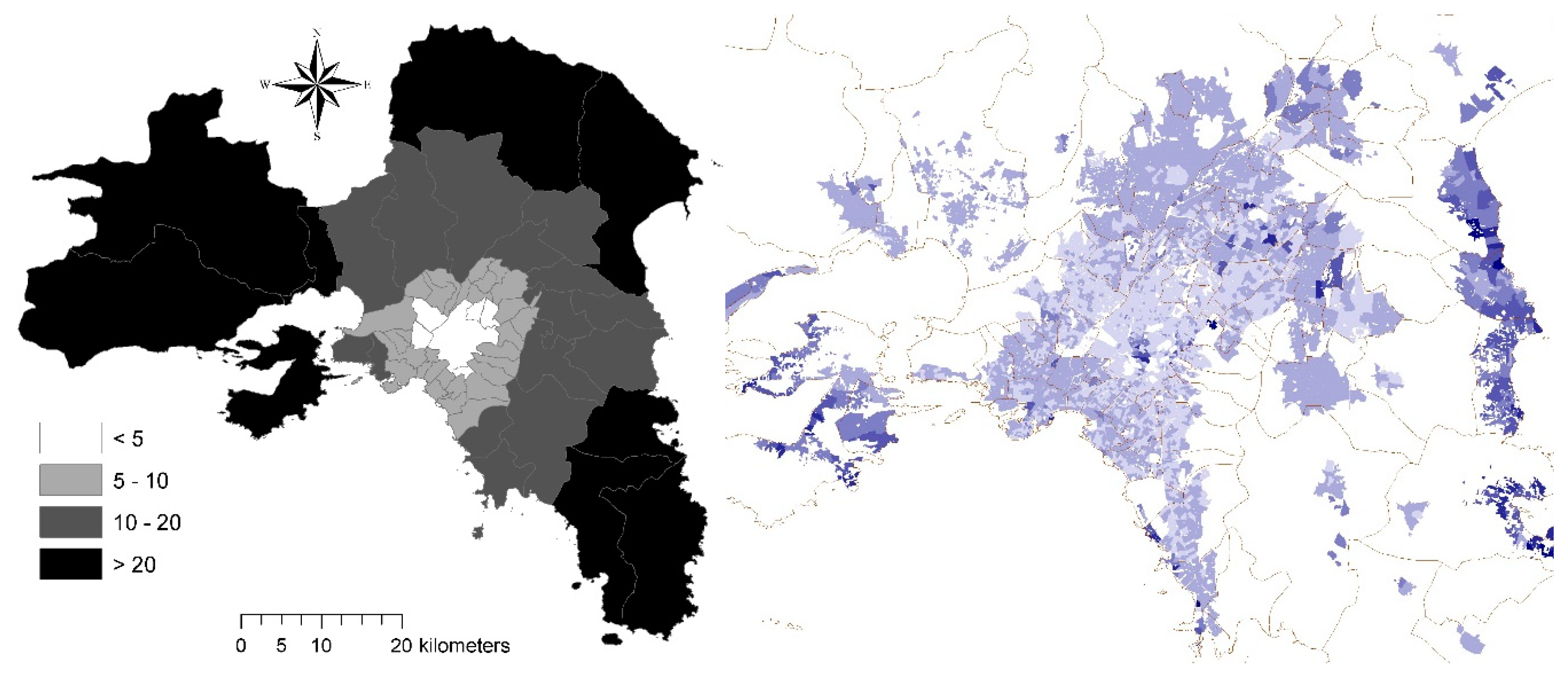
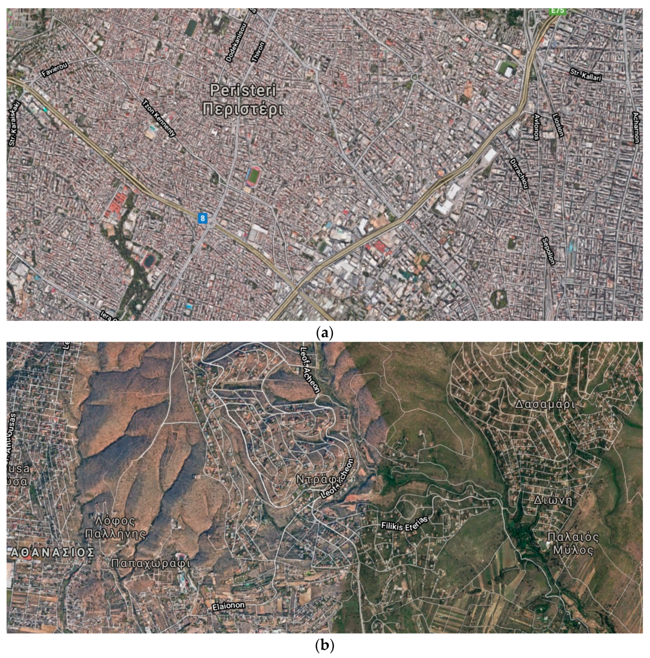
2.1. Study Area
2.2. Demographic Data
2.3. Statistical Analysis
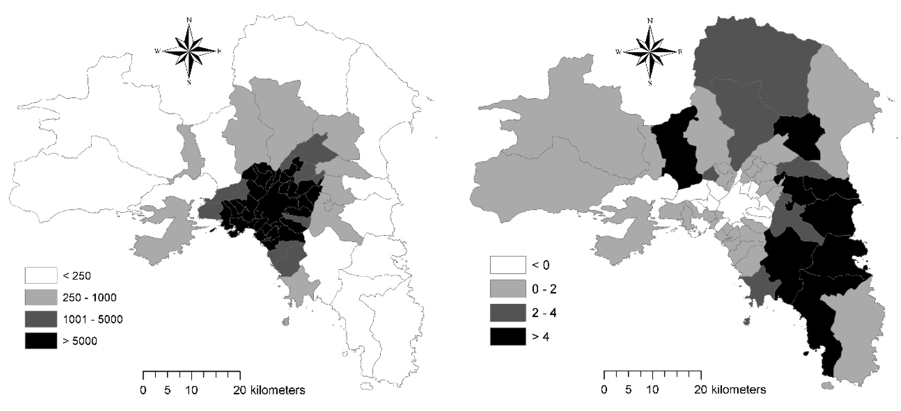
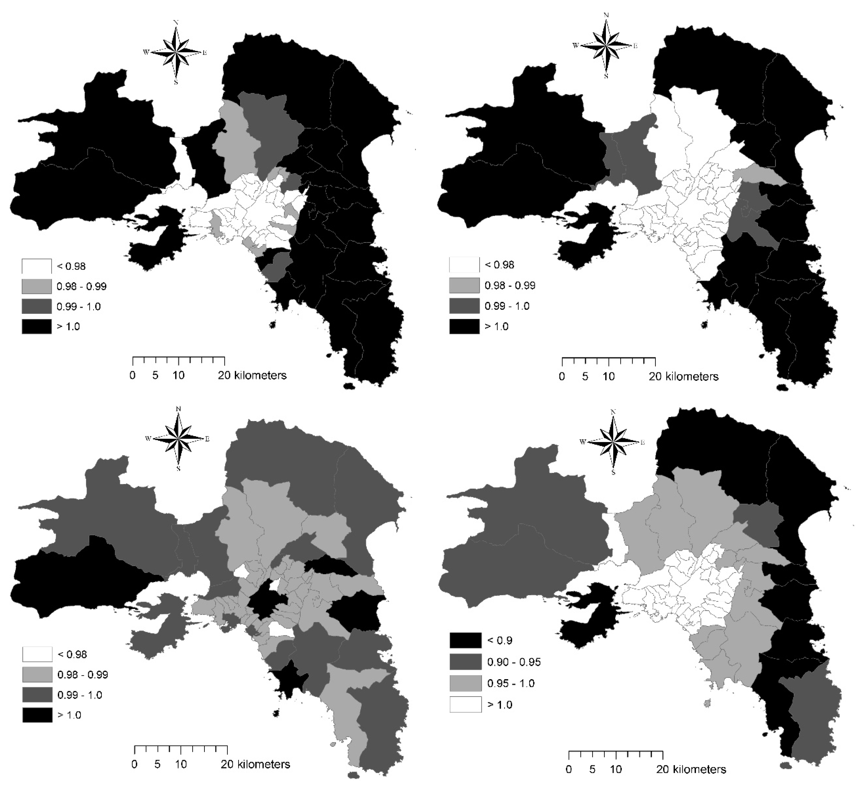
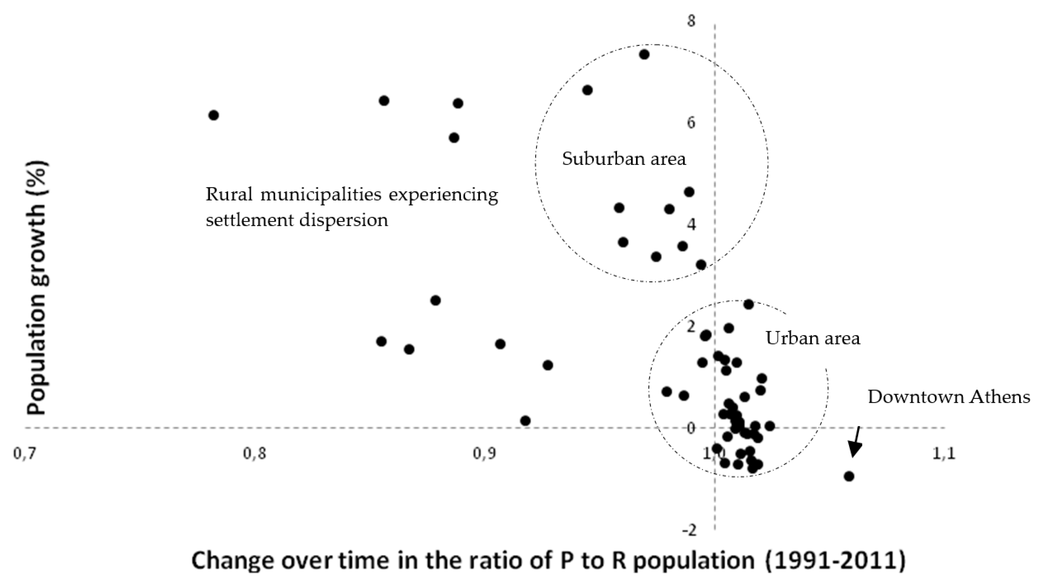
3. Results
4. Discussion
5. Conclusions
Author Contributions
Funding
Conflicts of Interest
References
- Angel, S.; Parent, J.; Civco, D.L.; Blei, A.; Potere, D. The dimensions of global urban expansion: Estimates and projections for all countries, 2000–2050. Prog. Plan. 2011, 75, 53–107. [Google Scholar] [CrossRef]
- Champion, A. Counterurbanisation: The Changing Pace and Nature of Population Decentralisation; Edward Arnold: London, UK, 1989. [Google Scholar]
- Kabisch, N.; Haase, D. Diversifying European agglomerations: Evidence of urban population trends for the 21st century. Popul. Space Place 2011, 17, 236–253. [Google Scholar] [CrossRef]
- Haase, A.; Kabisch, S.; Steinführer, A.; Bouzarovski, S.; Hall, R.; Ogden, P. Emergent spaces of reurbanisation: Exploring the demographic dimension of inner-city residential change in a European setting. Popul. Space Place 2009, 16, 443–463. [Google Scholar] [CrossRef]
- Couch, C.; Petschel-held, G.; Leontidou, L. Urban Sprawl in Europe: Landscapes, Land-Use Change and Policy; Blackwell: London, UK, 2007. [Google Scholar]
- Catalàn, B.; Sauri, D.; Serra, P. Urban sprawl in the Mediterranean? Patterns of growth and change in the Barcelona Metropolitan Region 1993–2000. Landsc. Urban Plan. 2008, 85, 174–184. [Google Scholar]
- Arapoglou, V.P.; Sayas, J. New facets of urban segregation in southern Europe—Gender, migration and social class change in Athens. Eur. Urban Reg. Stud. 2009, 16, 345–362. [Google Scholar] [CrossRef]
- Çakir, G.; Ün, C.; Baskent, E.Z.; Kose, S.; Sivrikaya, F.; Keleş, S. Evaluating urbanization, fragmentation and land use/land cover change pattern in Istanbul city, Turkey from 1971 TO 2002. Land Degrad. Dev. 2008, 19, 663–675. [Google Scholar] [CrossRef]
- Carlucci, M.; Chelli, F.M.; Salvati, L. Toward a New Cycle: Short-Term Population Dynamics, Gentrification, and Re-Urbanization of Milan (Italy). Sustainability 2018, 10, 3014. [Google Scholar] [CrossRef] [Green Version]
- Ciommi, M.; Chelli, F.M.; Carlucci, M.; Salvati, L. Urban Growth and Demographic Dynamics in Southern Europe: Toward a New Statistical Approach to Regional Science. Sustainability 2018, 10, 2765. [Google Scholar] [CrossRef] [Green Version]
- Delladetsima, P.M. The Emerging Property Development Pattern in Greece and its Impact on Spatial Development. Eur. Urban Reg. Stud. 2006, 13, 245–278. [Google Scholar] [CrossRef]
- Kasanko, M.; Barredo, J.I.; Lavalle, C.; McCormick, N.; Demicheli, L.; Sagris, V.; Brezger, A. Are European Cities Becoming Dispersed? A Comparative Analysis of Fifteen European Urban Areas. Landsc. Urban Plan. 2006, 77, 111–130. [Google Scholar] [CrossRef]
- Maloutas, T.; Siatitsa, D.; Balampanidis, D. Access to Housing and Social Inclusion in a Post-Crisis Era: Contextualizing Recent Trends in the City of Athens. Soc. Incl. 2020, 8, 5–15. [Google Scholar] [CrossRef]
- Kroll, F.; Kabisch, N. The Relation of Diverging Urban Growth Processes and Demographic Change along an Urban-Rural Gradient. Popul. Space Place 2011, 18, 260–276. [Google Scholar] [CrossRef]
- Van Criekingen, M. ‘Gentrifying the re-urbanisation debate’, not vice versa: The uneven socio-spatial implications of changing transitions to adulthood in Brussels. Popul. Space Place 2009, 16, 381–394. [Google Scholar] [CrossRef]
- Chen, Y. Urban chaos and perplexing dynamics of urbanization. Lett. Spat. Resour. Sci. 2009, 2, 85–95. [Google Scholar] [CrossRef]
- Benyaklef, M. Socio-economic disparities in the Mediterranean. Mediterr. Politics 1997, 2, 93–112. [Google Scholar] [CrossRef]
- Maloutas, T. Social and spatial impact of the crisis in athens-from clientelist regulation to sovereign debt crisis. Région Développement 2014, 39, 149–166. [Google Scholar]
- Gkartzios, M.; Scott, K. A Cultural Panic in the Province? Counterurban Mobilities, Creativity, and Crisis in Greece. Popul. Space Place 2015, 21, 843–855. [Google Scholar] [CrossRef] [Green Version]
- Roberts, S. A Critical Evaluation of the City Life Cycle Idea. Urban Geogr. 1991, 12, 431–449. [Google Scholar] [CrossRef]
- Pumain, D. Settlement systems in the evolution. Geogr. Ann. Ser. B Hum. Geogr. 2000, 82, 73–87. [Google Scholar] [CrossRef] [Green Version]
- Salvati, L. Urban containment in action? Long-term dynamics of self-contained urban growth in compact and dispersed regions of southern Europe. Land Use Policy 2013, 35, 213–225. [Google Scholar] [CrossRef]
- Maloutas, T. Social Segregation in Athens. Antipode 1993, 25, 223–239. [Google Scholar] [CrossRef]
- Kandylis, G.; Maloutas, T.; Sayas, J. Immigration, inequality and diversity: Socio-ethnic hierarchy and spatial organization in Athens, Greece. Eur. Urban Reg. Stud. 2012, 19, 267–286. [Google Scholar] [CrossRef]
- Bonifazi, C.; Heins, F. Testing the differential urbanisation model for Italy. Tijdschr. Econ. Soc. Geogr. 2003, 94, 23–37. [Google Scholar] [CrossRef]
- Maloutas, T. Promoting social sustainability The case of Athens. City 2003, 7, 167–181. [Google Scholar] [CrossRef]
- Lopez-Gay, A. Population growth and re-urbanization in Spanish inner cities: The role of internal migration and residential mobility. Quetelet J. 2014, 2, 67–92. [Google Scholar] [CrossRef] [Green Version]
- Rontos, K. Demographic Trends, Young People’s Attitudes towards Marriage and Socio-economic Changes Related to Family Formation in Greece and in the European Union: A Comparative Analysis Based on Official and Survey Research Data. Int. J. Econ. Bus. Adm. 2015, III, 11–33. [Google Scholar] [CrossRef]
- Champion, T.; Hugo, G. New Forms of Urbanization; Informa UK Limited: Colchester, UK, 2017. [Google Scholar]
- Gavalas, V.S.; Rontos, K.; Salvati, L. Who Becomes an Unwed Mother in Greece? Sociodemographic and Geographical Aspects of an Emerging Phenomenon. Popul. Space Place 2014, 20, 250–263. [Google Scholar] [CrossRef]
- Gil-Alonso, F.; Bayona-I-Carrasco, J.; Rúbies, I.P. From boom to crash: Spanish urban areas in a decade of change (2001–2011). Eur. Urban Reg. Stud. 2013, 23, 198–216. [Google Scholar] [CrossRef]
- Remoundou, K.; Gkartzios, M.; Garrod, G. Conceptualizing Mobility in Times of Crisis: Towards Crisis-Led Counterurbanization? Reg. Stud. 2015, 50, 1663–1674. [Google Scholar] [CrossRef] [Green Version]
- Copus, A.; Melo, P.C.; Kaup, S.; Tagai, G.; Artelaris, P. Regional poverty mapping in Europe—Challenges, advances, benefits and limitations. Local Econ. 2015, 30–38. [Google Scholar] [CrossRef]
- Connaughton, J.E. Local Economic Impact of the Great Recession of 2008/2009. RRS 2010, 40, 1–4. [Google Scholar]
- Tapia, F.J.B.; Díez-Minguela, A.; Martinez-Galarraga, J. Tracing the Evolution of Agglomeration Economies: Spain, 1860–1991. J. Econ. Hist. 2018, 78, 81–117. [Google Scholar] [CrossRef] [Green Version]
- Gkartzios, M. ‘Leaving Athens’: Narratives of counterurbanisation in times of crisis. J. Rural. Stud. 2013, 32, 158–167. [Google Scholar] [CrossRef]
- Goerlich, L.; Mas, M. La concentration spatiale de la population espagnole de 1900 à 2001: Confirmations empiriques. Population 2008, 63, 731–745. [Google Scholar] [CrossRef]
- Lerch, M. The Role of Migration in the Urban Transition: A Demonstration from Albania. Demography 2014, 51, 1527–1550. [Google Scholar] [CrossRef] [PubMed] [Green Version]
- Camagni, R.; Capello, R.; Caragliu, A. Static vs. dynamic agglomeration economies. Spatial context and structural evolution behind urban growth. Pap. Reg. Sci. 2015, 95, 133–158. [Google Scholar] [CrossRef]
- Dyson, T. The role of the demographic transition in the process of urbanization. Popul. Dev. Rev. 2011, 37, 34–54. [Google Scholar] [CrossRef] [PubMed]
- Ciommi, M.; Chelli, F.M.; Salvati, L. Integrating parametric and non-parametric multivariate analysis of urban growth and commuting patterns in a European metropolitan area. Qual. Quant. 2019, 53, 957–979. [Google Scholar] [CrossRef]
- Reynaud, C.; Miccoli, S.; Benassi, F.; Naccarato, A.; Salvati, L. Unravelling a demographic ‘Mosaic’: Spatial patterns and contextual factors of depopulation in Italian Municipalities, 1981–2011. Ecol. Indicat. 2020, 115, 106356. [Google Scholar] [CrossRef]
- Panori, A.; Ballas, D.; Psycharis, Y. SimAthens: A spatial microsimulation approach to the estimation and analysis of small area income distributions and poverty rates in the city of Athens, Greece. Comput. Environ. Urban Syst. 2017, 63, 15–25. [Google Scholar] [CrossRef] [Green Version]
- Garcia, S. The Breakdown of the Spanish Urban Growth Model: Social and Territorial Effects of the Global Crisis. Int. J. Urban Reg. Res. 2010, 34, 967–980. [Google Scholar] [CrossRef] [Green Version]
- González-Pérez, J.M. The Real Estate and Economic Crisis: An Opportunity for Urban Return and Rehabilitation Policies in Spain. Sustainability 2010, 2, 1571–1601. [Google Scholar] [CrossRef] [Green Version]
- Combes, P.-P.; Duranton, G.; Gobillon, L. The identification of agglomeration economies. J. Econ. Geogr. 2011, 11, 253–266. [Google Scholar] [CrossRef] [Green Version]
- Maloutas, T. Segregation, Social Polarization and Immigration in Athens during the 1990s: Theoretical Expectations and Contextual Difference. Int. J. Urban Reg. Res. 2007, 31, 733–758. [Google Scholar] [CrossRef]
- Lerch, M. Internal and International Migration Across the Urban Hierarchy in Albania. Popul. Res. Policy Rev. 2016, 35, 851–876. [Google Scholar] [CrossRef] [PubMed] [Green Version]
- Storper, M. Why do regions develop and change? The challenge for geography and economics. J. Econ. Geogr. 2010, 11, 333–346. [Google Scholar] [CrossRef] [Green Version]
- Frick, S.A.; Rodríguez-Pose, A. Change in urban concentration and economic growth. World Dev. 2018, 105, 156–170. [Google Scholar] [CrossRef]
- Chorianopoulos, I.; Tsilimigkas, G.; Koukoulas, S.; Balatsos, T. The shift to competitiveness and a new phase of sprawl in the Mediterranean city: Enterprises guiding growth in Messoghia—Athens. Cities 2014, 39, 133–143. [Google Scholar] [CrossRef]
- Panori, A.; Psycharis, Y.; Ballas, D. Spatial segregation and migration in the city of Athens: Investigating the evolution of urban socio-spatial immigrant structures. Popul. Space Place 2018, 25, e2209. [Google Scholar] [CrossRef]
- Bonavero, P.; Sforzi, F.; Dematteis, G. The Italian Urban System: Towards European Integration; Routledge: London, UK, 2009. [Google Scholar]
- Souliotis, N. Cultural economy, sovereign debt crisis and the importance of local contexts: The case of Athens. Cities 2013, 33, 61–68. [Google Scholar] [CrossRef]
- Petrakos, G.C. Urban Concentration and Agglomeration Economies: Re-examining the Relationship. Urban Stud. 1992, 29, 1219–1229. [Google Scholar] [CrossRef]
- Salvati, L.; Ferrara, A.; Chelli, F. Long-term growth and metropolitan spatial structures: An analysis of factors influencing urban patch size under different economic cycles. Geogr. Tidsskr. J. Geogr. 2017, 118, 56–71. [Google Scholar] [CrossRef]
- European Environment Agency. Mapping Guide for a European Urban Atlas; EEA: Copenhagen, Denmark, 2010. [Google Scholar]
- Monastiriotis, V. Examining the consistency of spatial association patterns across socio-economic indicators: An application to the Greek regions. Empir. Econ. 2008, 37, 25–49. [Google Scholar] [CrossRef]
- Pacione, M. Urban Geography: A Global Perspective; Routledge: London, UK, 2005. [Google Scholar]
- Rosti, L.; Chelli, F. Self-employment among Italian female graduates. Educ. Train. 2009, 51, 526–540. [Google Scholar] [CrossRef] [Green Version]
- Rosti, L.; Chelli, F. Higher education in non-standard wage contracts. Educ. Train. 2012, 54, 142–151. [Google Scholar] [CrossRef] [Green Version]
- Gigliarano, C.; Chelli, F.M. Measuring inter-temporal intragenerational mobility: An application to the Italian labour market. Qual. Quant. 2016, 50, 89–102. [Google Scholar] [CrossRef]
- Chelli, F.; Gigliarano, C.; Mattioli, E. The Impact of Inflation on Heterogeneous Groups of Households: An Application to Italy. Econ. Bull. 2009, 29, 1276–1295. [Google Scholar]
- Chelli, F.M.; Ciommi, M.; Emili, A.; Gigliarano, C.; Taralli, S. Assessing the Equitable and Sustainable Well-Being of the Italian Provinces. Int. J. Uncertain. Fuzziness Knowl. Based Syst. 2016, 24, 39–62. [Google Scholar] [CrossRef]
- Chelli, F.; Rosti, L. Age and gender differences in Italian workers’ mobility. Int. J. Manpow. 2002, 23, 313–325. [Google Scholar] [CrossRef]
- Maloutas, T. Contextual Diversity in Gentrification Research. Crit. Sociol. 2011, 38, 33–48. [Google Scholar] [CrossRef]
- Lamonica, G.R.; Chelli, F.M. The performance of non-survey techniques for constructing sub-territorial input-output tables. Pap. Reg. Sci. 2018, 97, 1169–1202. [Google Scholar] [CrossRef]
- Ciommi, M.; Gigliarano, C.; Emili, A.; Taralli, S.; Chelli, F.M. A new class of composite indicators for measuring well-being at the local level: An application to the Equitable and Sustainable Well-being (BES) of the Italian Provinces. Ecol. Indic. 2017, 76, 281–296. [Google Scholar] [CrossRef]
- Salvati, L.; Lamonica, G.R. Containing urban expansion: Densification vs greenfield development, socio-demographic transformations and the economic crisis in a Southern European City, 2006–2015. Ecological Indicators 2020, 110, 105923. [Google Scholar] [CrossRef]
- Aplerovich, G. An empirical study of population, density gradients and their determinants. J. Reg. Sci. 1983, 23, 529–540. [Google Scholar]
- Carson, D.B.; Carson, D.A.; Porter, R.; Ahlin, C.Y.; Sköld, P. Decline, Adaptation or Transformation: New Perspectives on Demographic Change in Resource Peripheries in Australia and Sweden. Comp. Popul. Stud. 2016, 41. [Google Scholar]
- Bosker, M. Growth, Agglomeration and Convergence: A Space-time Analysis for European Regions. Spat. Econ. Anal. 2007, 2, 91–100. [Google Scholar] [CrossRef]
- Davies, S. Regional resilience in the 2008–2010 downturn: Comparative evidence from European countries. Camb. J. Reg. Econ. Soc. 2011, 4, 369–382. [Google Scholar] [CrossRef]
- Billari, F.C.; Kohler, H.-P. Patterns of low and lowest-low fertility in Europe. Popul. Stud. 2004, 58, 161–176. [Google Scholar] [CrossRef]
- Peck, J. Austerity urbanism. City 2012, 16, 626–655. [Google Scholar] [CrossRef]
- Reher, D.S. Economic and Social Implications of the Demographic Transition. Popul. Dev. Rev. 2011, 37, 11–33. [Google Scholar] [CrossRef]
- Fuchs, R.J.; Demko, G.J. Rethinking population distribution policies. Popul. Res. Policy Rev. 1983, 2, 161–187. [Google Scholar] [CrossRef]
- Klasen, S.; Nestmann, T. Population, population density and technological change. J. Popul. Econ. 2006, 19, 611–626. [Google Scholar] [CrossRef] [Green Version]
- Monastiriotis, V. Making geographical sense of the Greek austerity measures: Compositional effects and long-run implications. Camb. J. Reg. Econ. Soc. 2011, 4, 323–337. [Google Scholar] [CrossRef]
- Palloni, A.; Tienda, M. Demographic Responses to Economic Recessions in Latin America Since 1900. Sociol. Inq. 1992, 62, 246–270. [Google Scholar] [CrossRef]
- Koutsampelas, C.; Tsakloglou, P. The distribution of full income in Greece. Int. J. Soc. Econ. 2013, 40, 311–330. [Google Scholar] [CrossRef] [Green Version]
- Cecchini, M.; Zambon, I.; Salvati, L. Housing and the city: A spatial analysis of residential building activity and the socio-demographic background in a Mediterranean city, 1990–2017. Sustainability 2019, 11, 375. [Google Scholar] [CrossRef] [Green Version]
- Lusardi, A.; Schneider, D.; Tufano, P. The Economic Crisis and Medical Care Use: Comparative Evidence from Five High-Income Countries. Soc. Sci. Q. 2014, 96, 202–213. [Google Scholar] [CrossRef]
- Stuckler, D.; Reeves, A.; Karanikolos, M.; McKee, M. The health effects of the global financial crisis: Can we reconcile the differing views? A network analysis of literature across disciplines. Health Econ. Policy Law 2014, 10, 83–99. [Google Scholar] [CrossRef]
- Simou, E.; Koutsogeorgou, E. Effects of the economic crisis on health and healthcare in Greece in the literature from 2009 to 2013: A systematic review. Health Policy 2014, 115, 111–119. [Google Scholar] [CrossRef] [Green Version]
- Li, Z.; Cheng, J.; Wu, Q.Y. Analyzing regional economic development patterns in a fast developing province of China through geographically weighted principal component analysis. Lett. Spat. Resour. Sci. 2015, 9, 233–245. [Google Scholar] [CrossRef]
- Rodríguez-Pose, A.; Fratesi†, U. Between Development and Social Policies: The Impact of European Structural Funds in Objective 1 Regions. Reg. Stud. 2004, 38, 97–113. [Google Scholar] [CrossRef]
- Schneider, D. The Great Recession, Fertility, and Uncertainty: Evidence from the United States. J. Marriage Fam. 2015, 77, 1144–1156. [Google Scholar] [CrossRef]
- Stockdale, A. Contemporary and ‘Messy’ Rural In-migration Processes: Comparing Counterurban and Lateral Rural Migration. Popul. Space Place 2015, 22, 599–616. [Google Scholar] [CrossRef] [Green Version]
- Dijkstra, L.; Garcilazo, E.; McCann, P. The effects of the global financial crisis on European regions and cities. J. Econ. Geogr. 2015, 15, 935–949. [Google Scholar] [CrossRef]
- Berg, M.V.D. City Children and Genderfied Neighbourhoods: The New Generation as Urban Regeneration Strategy. Int. J. Urban Reg. Res. 2012, 37, 523–536. [Google Scholar] [CrossRef]
- Kulu, H.; Boyle, P.J.; Andersson, G. High Suburban Fertility: Evidence from Four Northern European Countries. Demogr. Res. 2009, 21, 915–944. [Google Scholar] [CrossRef]
- Walford, N.S.; Kurek, S. Outworking of the Second Demographic Transition: National Trends and Regional Patterns of Fertility Change in Poland, and England and Wales, 2002–2012. Popul. Space Place 2015, 22, 508–525. [Google Scholar] [CrossRef] [Green Version]
- Dyson, T. On Demographic and Democratic Transitions. Popul. Dev. Rev. 2013, 38, 83–102. [Google Scholar] [CrossRef]
- Tapinos, G.; Mason, A.; Bravo, J. Demographic Responses to Economic Adjustment in Latin America; Oxford University Press: Oxford, UK; New York, NY, USA, 1997. [Google Scholar]
- Cechella, C.; Dentinho, T.P.; Silva, J.R. World centralities for political, demographic and market purposes. Lett. Spat. Resour. Sci. 2011, 5, 73–83. [Google Scholar] [CrossRef]
- Del Bono, E.; Weber, A.; Winter-Ebmer, R. Fertility and economic instability: The role of unemployment and job displacement. J. Popul. Econ. 2014, 28, 463–478. [Google Scholar] [CrossRef] [Green Version]
- Copus, A.; Mantino, F.; Noguera, J. Inner Peripheries: An oxymoron or a real challenge for territorial cohesion? Ital. J. Plan. Pract. 2017, 7, 24–49. [Google Scholar]
- Lesthaeghe, R.J.; Neidert, L. The Second Demographic Transition in the United States: Exception or Textbook Example? Popul. Dev. Rev. 2006, 32, 669–698. [Google Scholar] [CrossRef]
- Wheaton, W.C.; Shishido, H. Urban Concentration, Agglomeration Economies, and the Level of Economic Development. Econ. Dev. Cult. Chang. 1981, 30, 17–30. [Google Scholar] [CrossRef]
- Işık, O.; Pinarcioğlu, M.M. Geographies of a silent transition: A geographically weighted regression approach to regional fertility differences in Turkey. Eur. J. Popul. 2007, 22, 399–421. [Google Scholar] [CrossRef]
- Cherlin, A.; Cumberworth, E.; Morgan, S.P.; Wimer, C. The Effects of the Great Recession on Family Structure and Fertility. Ann. Am. Acad. Political Soc. Sci. 2013, 650, 214–231. [Google Scholar] [CrossRef]
- Goldstein, J.; Örsal, D.D.K.; Kreyenfeld, M.; Jasilioniene, A. Fertility Reactions to the “Great Recession “ in Europe. Demogr. Res. 2013, 29, 85–104. [Google Scholar] [CrossRef] [Green Version]
- Lee, K.O.; Painter, G. What happens to household formation in a recession? J. Urban Econ. 2013, 76, 93–109. [Google Scholar] [CrossRef]


| Acronym | Description | Source |
|---|---|---|
| Dependent variables | ||
| P-R | Ratio of present-to-resident population in 1991 | Census of population |
| P-R’ | Change in the ratio of present-to-resident population (1991–2011) | Census of households |
| Predictors | ||
| Density | Density of resident population in 1991 (inhabitants/km2) | Census of population |
| Dynamics | Population growth rate (1991–2011), % | Census of population |
| Adjacency | Adjacent buildings (% share in total building stock) | Census of buildings |
| Distance | Average distance from downtown Athens (km) | ELSTAT cartography |
| Variable | β | St. Error | t | p | rs |
|---|---|---|---|---|---|
| (a) Ratio of present-to-resident population, 1991: Adjusted R2 = 0.68, F(4,54) = 31.9, p < 0.001 | |||||
| Density | 0.133 | 0.117 | 1.14 | 0.26 | −0.83 |
| Dynamics | 0.037 | 0.122 | 0.30 | 0.76 | 0.63 |
| Adjacency | 0.521 | 0.142 | 3.68 | 0.00 | 0.86 |
| Distance | −0.441 | 0.180 | −2.45 | 0.02 | −0.83 |
| (b) Per cent change over time (1991–2011) in the ratio of present-to-resident population: Adjusted R2 = 0.71, F(4,54) = 32.7, p < 0.001 | |||||
| Density | −0.155 | 0.109 | −1.42 | 0.16 | 0.78 |
| Dynamics | −0.278 | 0.123 | −2.26 | 0.03 | −0.74 |
| Adjacency | −0.599 | 0.128 | −4.67 | 0.00 | −0.77 |
| Distance | 0.213 | 0.175 | 1.22 | 0.23 | 0.82 |
© 2020 by the authors. Licensee MDPI, Basel, Switzerland. This article is an open access article distributed under the terms and conditions of the Creative Commons Attribution (CC BY) license (http://creativecommons.org/licenses/by/4.0/).
Share and Cite
Rontos, K.; Colantoni, A.; Salvati, L.; Mosconi, E.M.; Morera, A.G. Resident or Present? Population Census Data Tell You More about Suburbanization. Land 2020, 9, 383. https://doi.org/10.3390/land9100383
Rontos K, Colantoni A, Salvati L, Mosconi EM, Morera AG. Resident or Present? Population Census Data Tell You More about Suburbanization. Land. 2020; 9(10):383. https://doi.org/10.3390/land9100383
Chicago/Turabian StyleRontos, Kostas, Andrea Colantoni, Luca Salvati, Enrico Maria Mosconi, and Antonio Giménez Morera. 2020. "Resident or Present? Population Census Data Tell You More about Suburbanization" Land 9, no. 10: 383. https://doi.org/10.3390/land9100383