Article

Post-Conflict Urban Landscape Storytelling: Two Approaches to Contemporary Virtual Visualisation of Oral Narratives

1
Department of Landscape Architecture, Estonian University of Life Sciences, F. R. Kreutzwaldi 1, 51006 Tartu, Estonia
2
Institute of Agricultural and Environmental Sciences, Estonian University of Life Sciences, F. R. Kreutzwaldi 1, 51006 Tartu, Estonia
*
Author to whom correspondence should be addressed.
Land 2024, 13(4), 406; https://doi.org/10.3390/land13040406
Submission received: 16 February 2024 / Revised: 19 March 2024 / Accepted: 20 March 2024 / Published: 22 March 2024
(This article belongs to the Special Issue Landscape Governance in the Age of Social Media (Second Edition))

Abstract

:
Armed conflicts and resulting displacement disrupt people’s sense of place, leading to an imbalance in the people–place relationship, exaggerated by rehabilitation efforts that overlook the sense of place among conflict- and displacement-impacted communities. A continuous landscape narrative that extends from pre- to post-conflict times contributes to recreating the essence of lost landscapes and therefore reconnecting their sense of place. Focusing on a Syrian city that hosted internally displaced persons (IDPs) in the aftermath of the Syrian conflict, this study aims to structure a virtual landscape and narrative depiction of conflict-impacted landscapes. This study proposes a storytelling approach for narrative construction and an AI-powered visualisation approach to revive the image of the elusive landscapes. This study utilised qualitative research methods through in-depth, semi-structured interviews for data collection and an online survey for exploring the perception of virtual landscape images generated with AI text-to-image models (DALL.E 2 and Bing Image Creator). This study indicates that narratives, supported by AI visualisation, are reliable for comprehending landscape transformation and changes in the sense of place. The two approaches can serve as rehabilitation initiatives in post-crisis settings to recall images of elusive landscapes to save them from being lost forever.

1. Introduction

Armed conflicts, along with the waves of displacement they generate, disconnect people from their places. Characterised by their disruptive nature and destructive impacts, armed conflicts and displacement cause profound transformations in the physical, social, and cultural landscapes [1,2], leading to a gross imbalance in the dynamics of people–place relationships [3].
These cause negative impacts across time and impact people’s sense of place. A sense of place is shaped by the values and beliefs of individuals and communities within a landscape. It is dependent on the experiences of place and therefore is an evolving process [4,5,6,7,8,9].
In post-conflict settings, landscape rehabilitation initiatives typically prioritise rehabilitating the physical structures in the urban contexts, overlooking the social and cultural aspects, and disrupting the sense of place further. Therefore, this focus on the physical contexts widens the emotional gap between people and their places, resulting in a sense of alienation among people targeted by these initiatives within the places they accommodate [10].
Riessman [11] explains that narratives are the main way in which individuals make sense of their experiences which particularly applies to the situation after traumatic events. Thus, to connect what has been disconnected and maximise the effectiveness and efficiency of rehabilitation programmes, it is important to establish a continuous narrative of the landscapes that extends from pre-conflict times, continues through the conflict, and concludes with the post-conflict phase. Through the narrative introduced in this study on post-conflict landscapes, a thorough understanding can be developed of the factors that create a sense of place; therefore, it is possible to recreate its essence, aiding in reconnecting people to the landscape. This can inform rehabilitation policies to introduce initiatives to reconnect people back to the landscapes post-crises and to prevent inadvertently being a source of further disruption of the perceived landscapes.
This study aims to structure a virtual landscape and narrative depiction of post-conflict landscapes, supported by artificial intelligence (AI) visualisation. It focuses on exploring the landscape layers and transformations these layers have been through, along with the essence of the sense of place, through individual oral narratives of conflict- and displacement-impacted individuals.

1.1. Narrative Definition

The notion of narrative is borrowed from the social science literature. According to Elliott [12], the narratives need to be “chronological”, representing a set of sequential events; “meaningful”, providing a meaning out of this sequence; and they need to be “inherently social” through being introduced to a specific group and/or groups of audience. Jovchelovitch & Bauer [13], however, focused on the temporal dimension of narratives, arguing there are two dimensions in storytelling—a “chronological” dimension and a “non-chronological” dimension—involving constructing a comprehensive whole from the events in sequence or as a plot formation. The meanings of the stories are woven through the whole story and not only concluded at the end. Therefore, Jovchelovitch & Bauer [13] underpin Elliott’s [12] statement that chronological order is needed, but the plot meanings may be reflected in a non-chronological dimension.
Clandinin [14] took a different approach and developed a metaphorical narrative inquiry space based on three dimensions: “interaction”, to achieve a balance between what is personal and what is social; “continuity”, to address temporality in narrative from the past to present directing to future; and “situation”, where events occur within specific places. Elliott [12] and Clandinin [14], however, acknowledged the importance of the social dimensions of the narrative.
A narrative, therefore, should contain a sequential order of events or a sense of continuity, as well as include personal experiences to create a whole, giving context to the audience [11,12,15]. Labov [16,17] and Labov & Waletzky [15] in Riessman [11] (p. 18) argue that “fully formed” narratives should incorporate the element of orientation which encompasses time, place, situation, and participants. Personal stories give insight into the past and can serve different purposes, they can be a summary of past events, they can be illustrative to make a point characterised by a moral conclusion, or they can be used to transfer knowledge [11,12,18]. The narratives are representative in nature, and are not a mirror of the world [13]. They are an interpretation of a person’s history from their perspective, as they are “constructed, creatively authored, rhetorical, and replete with assumptions”, where the borders between fact and interpretation are fuzzy [11] (p. 5).

1.2. Why Tell Stories/Narrate

The importance of storytelling/narrating lies in its function as an essential, universal means of human communication. Introducing everyday experiences through the storytelling template contributes to providing explanations for the various events that individuals and communities encounter [13]. Moreover, narratives are an effective means to understand the research subject as well as the process of change that happens in a specific context [12].
They also enable individuals and/or communities to process their experiences in a meaningful way, providing a sense of self that continues through time [12]. In times of disruptive events, narratives may be all that a person has, and, in these cases, their importance lies beyond being sources of entertainment; they are the meaning of an individual’s life that needs to be fought for [14]. Deploying narratives can be especially beneficial in the case of an event that contains “hot” issues, where the voices of stakeholders are vulnerable to being marginalised. These voices introduce different novel patterns of perspectives and dynamics to the descriptions of an event to be incorporated into the overall narrative and reflecting the larger socio-historical context [13] (p. 9). These alternative narratives help in understanding the causes of current change patterns and Elliott [12] (p. 7) argues that narratives often include an implicit “causal link” between events. Schütze [19] in Jovchelovitch & Bauer [13] states that stories centred around persecution and political exile are classic examples.

1.3. Recent Endeavours in Artificial Intelligence in Landscape Architecture

The notion of AI itself is not novel [20]; however, the unprecedented, fast-paced developments in machine learning and artificial intelligence led to the need to redefine AI by identifying the new roles it plays in various fields. Oxford Reference [21] defines AI as “the theory and development of computer systems able to perform tasks normally requiring human intelligence, such as visual perception, speech recognition, decision-making, and translation between languages”.
In the realm of landscape architecture, there has been a continuous development in design computation and information modelling in the design process, e.g., terrain modelling and monitoring public spaces for design assumptions [20].
Moreover, machine learning and artificial intelligence were deployed in urban landscape design to classify land uses, urban settlements, and landscape patterns, as well as develop “crowd-sourced systems that enable urban communities to report and document urban landscape characteristics” [22] (pp. 221–222) or for participatory design [23].
Research exists that uses AI text-to-image models for visualisation [24,25] and in landscape design [22,26]. Most of the recent scholarship, though, centres around evaluations of the quality and representation of images generated by different text-to-image models [25] or a specific text-to-image model by a human or a system with a human in the loop [27] using quantitative methods. To our knowledge, no research combines both aspects used in this paper that aim to fill that research gap by developing a qualitative approach for landscape visualisation that enables non-professionals without the relevant artistic skills to generate representative AI images.
This study aimed to describe the landscape narratives of displacement-impacted persons using a case study of a city in Syria and to evaluate the usefulness of AI-generated images to facilitate this process. This study, therefore, aimed to shed light on the complexities of visualising landscapes altered by armed conflicts and disasters in the absence of archival records. It addresses key questions regarding tools and sources for representation, especially if these landscapes were not represented in previous archival records.

2. Materials and Methods
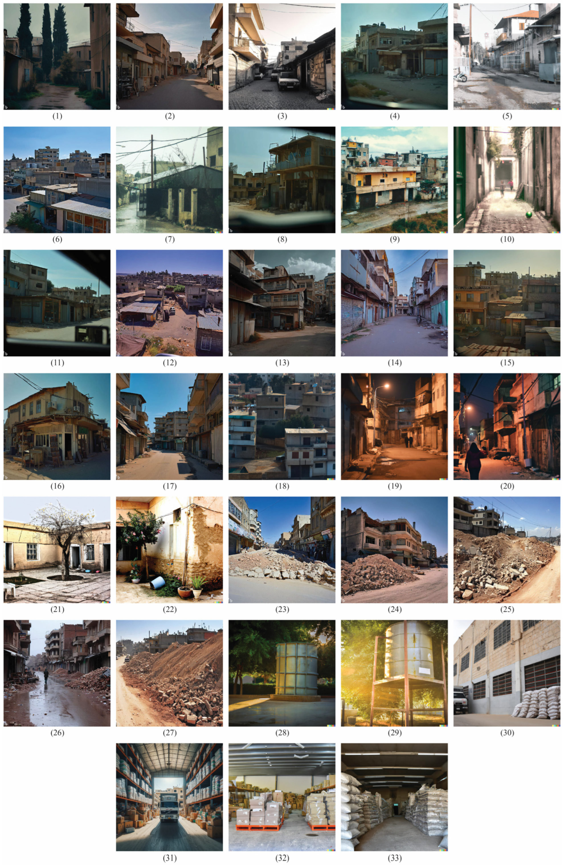
2.1. Study Area

The armed conflict in Syria, which erupted in 2011 following a series of demonstrations across Arabic-speaking countries and termed the ‘Arab Spring’, led to vast destruction that impacted the urban and rural settings [28,29]. Consequently, there were waves of external and internal displacement [30,31] with the Syrian people still suffering from its ongoing impacts.
The displaced populations were either refugees or internally displaced persons (IDPs), depending on their geographical location in relation to the state border. A refugee is someone who crosses internationally recognised State borders and is “unable or unwilling to return to their country of origin” due to fear related to persecution [32] (p. 3), while IDPs are persons or groups of persons who were “forced or obliged” to leave their homes as a result of armed conflict, generalised violence, human rights violation, or natural or human-made disasters, and did not cross an “internationally recognised State border” [33] (p. 1).
This study focuses on a study case of a Syrian city that acted as a destination for IDPs and had been through transformations in its physical, social, and cultural landscapes. The name of the city is not revealed in this study due to the research’s ethical considerations.

2.2. Research Methods

2.2.1. Storytelling Approach: The Virtual Landscapes of the Mind

The European Landscape Convention [34] (p. 2) defines landscape as “an area, as perceived by people, whose character is the result of the action and interaction of natural and/or human factors”. The personal and collective perceptions, therefore, serve as determinants of the landscape narrative, drawing on collective landscape stories adopted by individuals—in other words, a virtual landscape as perceived by the community. Richardson [35] (p. 6) argues that “The collective story displays an individual’s story by narrativising the experiences of the social category to which the individual belongs, rather than by telling the particular individual’s story or by simply retelling the cultural story”.
Elliott describes a holistic approach in an effort to maintain the narrative’s entity and introduce an understanding of the components of the text within the overall context of the narrative. She argues that it is possible to establish a collective story for a specific community that represents its members’ shared experiences by “identifying the common elements in the trajectories” of individuals’ stories [12] (p. 40).
The storytelling approach is based on the following main elements:
(1)
Individual oral narratives related to the lived experiences of conflict-impacted persons
Schenck & Reed [36] argue that a change is needed to incorporate oral narratives into historical scholarship as the oral narratives can help to highlight the connectedness between authors, sources, and formal historical narratives, leading to further engagement of the reader/audience into the conversation. As Riessman [11] (p. 2) states, “Nature and the world do not tell stories, individuals do”; this study, therefore, relies on the narratives of individuals as references for narrating the landscape story.
In this context, the narratives’ content functions in two ways, as follows: descriptive of past events in chronological order, and evaluative, which explicitly introduces the meaning of lived experiences and events to the audience requiring participation in the narrative inquiry [12,14].
(2)
Creating a landscape timeline through a three-phased approach to explore the before, during, and after phases of the conflict, where the conflict serves as a decisive moment in the landscape’s narrative (Figure 1).
As Elliott [12] (p. 7) argues, time has a “uni-linear direction” in stories, flowing from the past through the present into the future, where the role of the plot is to connect prior choices with subsequent events to formulate comprehensive narratives. Usually, the description of the change is an inherent part of the stories, as the events tend to disrupt an “initial state of equilibrium”. Consequently, these plots are generated from an interplay between time and cause and effect, which perform a vital role in the storytelling giving them meaning. They become tools for structuring memories and “purpose-building” life events [11,12,13] (p. 2). The production of meaning provides coherence to the narrative for understanding events, relationships, and characters [13].
Plots demarcate when the story starts and when it ends by defining the “temporal range”, contributing to making sense of life events and social phenomena. Moreover, the plot functions as a criterion for selecting the events that need to be incorporated into the narrative and creating a cohesive sequence of these events that can express the meanings of the events within the overall narrative [13] (p. 5).
The ‘before’ phase embraces a description of the landscape history to provide a nuanced understanding of the dynamics of interrelation between the physical, social, and cultural structures and therefore contributes to the understanding of change. While ‘during’ focuses on the forms of landscape change and the direct and indirect causes behind them, the ‘after’ describes the current situation of the landscape and the impact of the change.

2.2.2. Validity of Oral Narratives as the Main Source of Information

It is important to raise the issue of individual stories’ validity. Hollway & Jefferson [37] (p. 304) see that these narratives may not provide a “transparent account” for conveying the truth, but argue that storytelling approaches align with real-life events more than other research methods that “elicit” explanations. Elliott [12], Jovchelovitch & Bauer [13], and Portelli [38] all argue that the narratives should not be judged on how true or false they are, but on how they express what is true from the point of view of the narrators within a specific space and time. The strength of these oral sources lies in the “errors, inventions and myths” that lead to meanings [38] (p. 2).
This study draws upon the work of Schenck & Reed [36] in promoting the voices of refugees and immigrants through a collection of oral narratives as an alternative solution to archiving materials. They argued in their preface, which sets the academic reasoning for the narratives, that it is possible to build archives where there is a lack of conventional accessibility to archives, through interviews and observations, serving as a “counterpoint to the archival logics” that dominate agency archives [36] (p. X). They describe participants in their research as “non-traditional” historians who introduce rarely heard voices into narrative creation. Thus, it contributes “to new knowledge and to add new significance, the narrator must both acknowledge and contradict the power embedded in previous understanding”. Moreover, they indicate the “translocal” concept as it emphasises the need for establishing “new archives” through oral narratives that can capture experiences and processes that may have failed to be revealed within the “colonial or postcolonial archives” [36] (p. II).
The destructive nature of conflicts and displacement usually means a loss of archives; either formal archives represented in the tangible and intangible damage to the foundations that preserve national and local archives, or informal archives represented in personal belongings, photos, and materials of people impacted by conflict and displacement. The narratives therefore represent a valid virtual landscape that encapsulates memories and meaning for displaced and host populations.

2.2.3. Data Collection through Narrative Interviews

In-depth, semi-structured interviews were conducted to explore the personal stories and lived experiences of conflict-impacted persons regarding place experience, place attachment, place identity, as well as landscape transformation. The audience targeted in the interviews included residents from the study area, IDPs who moved to the study area following the armed conflict, and refugees who originally came from the study area and lived in the diaspora after their external displacement experience. To ensure a diversity of views, interviews were conducted with individuals from different backgrounds, with different residency statuses, genders, ages, and variations in place experience. The samples in this study included 11 interviewees (Table 1) who were selected based on purposive sampling, an intentional, non-random sampling method where samples are selected based on criteria [36,39,40,41]. Moreover, the deployment of the Snowball technique contributed to expanding the sample size, where some interviewees nominated potential candidates to conduct interviews with. This technique facilitated building rapport and promoting trust between the researcher/interviewer and interviewees, especially important in an environment of instability [9,42]. It also helped in reducing the personal connection bias that results from the former personal connection/relationship between the researcher/interviewer and interviewees [39].
The table indicates that refugees tend to be young adults seeking safety and better life conditions abroad, while the majority who stayed in the city are females from different age groups. The IDPs who live in the city are young individuals who were able to stay for the purpose of studying at university.
Initial contact with the potential interviewees (candidates) was made through online means of communication, i.e., Skype version 8.114.0.214 and WhatsApp Version 2.2410.2.0. During this contact, the researcher explained the purpose, scope, and potential risks of research, as well as the ethical considerations [43]. In this study, the informed consent included oral approval on conducting the interview where ‘no official papers were signed’ due to the distrust of official paperwork. Interviews were conducted online due to the geographical distance between the researcher and the interviewees. The interviews were in Arabic where voice and video were not recorded, as a part of the research ethics and to promote a safe environment for the interviewees. However, notes were taken during the interview, after the approval of the interviewees, followed by writing a more detailed transcript afterwards using the notes. These notes were “clean” or “sanitised” transcripts, where non-lexical utterances, pauses, and false starts were not included in the transcript [12] (p. 52).
Data collection went through an iterative process, wherein the interview questions were constantly updated based on the themes that emerged during data collection/interviews until “saturation” was achieved. Saturation is where the researcher finds some elements of the narrative emerging frequently in the later interviews to confirm elements from previous ones [12] (p. 40).

2.2.4. Protocol of Interviewing in Highly Sensitive Contexts

Elliott [12] (p. 134) identifies the notion of what is ‘ethical’ to indicate “issues that relate to the relationship between the researcher and the research subjects” and the potential impacts of research on the interviewees. Political conditions can be an obstacle for people to narrate about specific events, which needs to be taken into consideration [11]. Since the research topic also included evoking memories of places in post-conflict contexts that could potentially trigger traumas, research ethics were highly prioritised and an integral part of this study.
Empathy or “imaginative reconstruction” as Elliott [12] (p. 37) identifies, is important in qualitative research, which cannot be easily captured by algorithms or methods. She states that empathy helps to approach individual experiences from the perspective of the narrators/interviewees. In this context, narratives can be considered to be devices for fostering empathy and a space for promoting communication.
In this study context, and during data collection, the researcher/interviewer worked on creating a safe space for interviewees to be able to talk about their experiences through a set of procedures before and during the interviews and through being a good listener. Building rapport between researchers and interviewees helped to obtain data. The principles of safeguarding and do no harm were included in the interviewing procedures to avoid triggering traumas and causing any (psychological) harm to the interviewees [44], as well as to the researcher, as a previous inhabitant in the study area.
Aliases were used to anonymise the identities of interviewees [45] through a coding system to identify the interviewees, based on three factors; gender, age, and residency status. Each alias is composed of two abbreviations and a number (M/F, Number, R/D/Re), where M/F refers to the gender of the interviewee, either Male or Female; the numerical value signifies the age of the interviewee; and the R/D/Re stands for residency status, whether a resident, internally displaced person or a refugee. For instance, F32Re is a 32-year-old femalerefugee. Additionally, the name of the study area was also anonymised by using an (S) letter indicating the Syrian city.
In order to respect the interviewees’ confidentiality, any information that could reveal their identities was removed, such as residential locations, professions, or place names mentioned during the interview. The sensitivity towards local environments was also emphasised [44,46].
Thematic analysis was used to code the narratives using an iterative approach to map themes and patterns in data [13,47,48]. The process of coding was facilitated through the utilisation of NVivo 12 software Release 1.7.1 (1534).

2.2.5. Virtual-Real Landscapes

In the situations of extreme, deep transformations that result from armed conflicts, natural disasters, and/or environmental destruction, a dilemma arises for visualising these altered landscapes, particularly those that were not represented in previous archival records. Various questions emerge regarding the visualisation mechanisms, tools, and sources for revitalising these landscapes’ images. In this study’s context, the loss of archives and ethical considerations of the research led to the development of an AI-powered visualisation approach as an alternative to identifying means of visual representation, i.e., maps and real-life images.
The ethical considerations, in this respect, were linked to how landscapes can be represented without giving place details that could identify interviewees.
This approach was developed to depict lost landscapes and/or places that cannot be physically accessed. Qualitative data derived from the perspective of the interviewees, their landscape description, and place experience were deployed to build comprehensive, reflective prompts to be used in AI text-to-image models to generate representative images. Hence, this approach enables the creation of images that do not necessarily capture real landscapes, but picture virtual representations of them that reflect their essence without having a tangible presence in the physical reality of the current landscape.

2.2.6. AI-Powered Visualisation Approach

Konarieva et al. [49] (p. 65) raise the issue of using qualitative data or “big texts” to generate AI images. In this regard, they suggest extracting keywords through “generating annotations, finding key phrases, or choosing certain words or word combinations”.
In their analysis of the capabilities of a text-to-image model, i.e., DALL.E 2 [50], for capturing the essence of urban environments, Seneviratne et al. [27] introduced an approach for writing prompts that can generate representative images. They suggested four dimensions of urban environment representation: the image format domain, geography of generated images, urban quality, and urban unit of analysis.
The AI-powered visualisation approach draws upon Konarieva et al.’s [49] suggestions for keyword extraction and Seneviratne et al.’s [27] approach to composing prompts. These can be classified into three categories: (1) physical elements, which define the components of the image by considering the spatial context and the nature of the elements within the landscape; (2) atmosphere that distinguishes the generated image by mapping the environmental condition, geographical location, daytime, and season; and (3) emotions, playing a role in creating human-centred visual products by conveying personal perceptions of places, relying on memories and associated feelings rather than simply replicating camera captures (Figure 2).
Two AI text-to-image models, DALL.E 2 [50] and Bing Image Creator [51], were used when implementing this approach. The purpose of choosing these models is their easy accessibility, which facilitates their use by practitioners and non-practitioners. This contributes to amplifying marginalised voices and promoting their rights in visual narration, so their voice is not lost in historical narratives of conflict [36]. Physical characteristics and elements such as location and season were derived from the landscape narratives and used as prompts to generate the images.
In total, 192 images were generated using both models, with 116 images generated using Bing Image Creator and 82 images with DALL.E 2 (Table 2). More images were generated with Bing Image Creator due to its capability to provide a larger pool of shots for image generation compared to DALL.E 2.

2.2.7. Validity of AI-Generated Images

Since oral narratives are the main source for generating AI images, and drawing on the arguments of Elliott [12], Hollway & Jefferson [37], and Jovchelovitch & Bauer [13] on the validity and accuracy of oral narratives, validating these AI-generated images is subject to the same argumentation.
Due to the novelty of this approach and the lack of research in this area, the AI-powered visualisation approach is employed to set criteria for validating the representation of the AI-generated images.
Images were sent to the previous interviewees in the form of an online survey (Appendix A) to assess their accuracy and representation according to the three categories of prompt writing; physical elements, atmosphere, and emotions. In total, 33 AI-generated images were selected for the online survey based on inclusion/exclusion criteria (Table 3), with 18 images generated with Bing Image Creator and 15 images with DALL.E 2 (Table 2). The criteria included the constructive details of infrastructure, cultural indicators, building types, functional appearance, and image visualisation style. For instance, some earthen berm images resembled rubbles on construction sites, contradicting the appearance of earthen berms installed for protective purposes, leading to excluding them from the online survey.
The representation of each sent image was validated on a 5-point Likert scale: very low, low, medium, high, and very high, and the results were reflected through a heat map where green indicated a low score, yellow medium, and red a high score (Appendix B). Space was also given for comments by the respondents.
It is worth mentioning that due to the difficulties in reaching previous interviewees, M69R could not be reached; therefore, only ten online surveys were conducted.

2.2.8. Methodology Overview

The methodology overview shows how the research stages were conducted (Figure 3). The first stage involves narrative interviews to construct a landscape timeline using the storytelling approach, followed by generating images employing the AI-powered visualisation approach, utilising Bing Image Creator and DALL.E 2. A number of images were selected based on the inclusion/exclusion criteria (Table 3) and validated through online surveys in the second round of interviews (online survey).

3. Results and Interpretation

To provide a nuanced landscape narrative, a set of sub-narratives were introduced to narrate each of the landscape layers separately: physical, social, and cultural, as well as the sense of place, starting with a beginning, moving to a plot, and then closes with a conclusion for each. The physical landscape indicates the visible features of a specific geographical area including landforms, settlements, and any other physical characteristics, while the social landscape refers to human actions and interactions within a particular geographical context. The cultural landscape is the result of the interplay between human activities, traditions, and beliefs, reflected in the surrounding environment [52].
The AI-generated images contributed to illustrating the landscape description embedded in the interviews, building a qualitative data-based depiction.
The iterative approach in interviewing/data collection contributed to updating the interview questions; this way, the interviewees’ participation in ‘framing’ research was integrated despite being implicit.
In this study’s context, a physical landscape refers to every spatial expression of social values and cultural practices. In general, the interviewees expressed an association between the social fabric and spatial environment.

3.1. Physical Landscape

3.1.1. Physical Landscape Narrative: The Beginning

The landscape story begins with the house, the main unit that forms the city. The city is defined through this unit where people were born, grew, experienced life, and raised their children, with a life cycle that is repeated with new generations. The hierarchy of the physical structure starts with houses, which is when adjacent duplication forms neighbourhoods and the neighbourhood sets shape the city.
I’m attached to every detail in this house. Thirty-five years in this house. Every little detail (F56R)
Some aspects of my house formed my identity and character. They are so close to my heart (M40R)
Houses were a reflection of the local social norms and cultural values, as well as the surrounding natural environment. The internal house design is shaped to serve daily life routines in a climate that can be hot in summer and uses landscape elements by employing clay as a building material and planting trees in the internal yard for shade (Figure 4).
My parent’s house was an old clay house, full of cosiness. Houses at that time were small and compact, and they were incubators for the families. They used to have one or two rooms, that accommodated the whole of life’s routines (M69R)
Back in time, one or two families had settled in this space and built their houses. Then, their children got married and settled in the same place; the children of the children did the same. So, the neighbourhood is a couple of families that lived here from the days of the grandparents until the times of the grandchildren (F33R)
Neighbourhoods were developed through an “organic, multi-generational” process [39] (p. 22). In the 19th century, a few families left their villages from certain regions around Syria to escape genocide and sought shelter and safety in another place, leading them to settle in the city of (S). These families lived next to each other with relatively distant interspaces, concentrated mainly around the historical part of the city, which transformed later into the city centre. After a while, new families started immigrating to (S) to live next to their relatives, developing neighbourhoods that were composed of one big family or a few smaller families located in one geographical spot. As time passed, each new familial generation started expanding within the spatial frame of their social network, leading to a denser structure of these neighbourhoods. Marriage relationships across families led to more heterogeneity in neighbourhoods, resulting in a compact expansion of neighbourhoods with no strict physical borders or vast spaces between (Figure 5).
Political and social shifts, which Syria had been through during the 19th and 20th centuries, were reflected in the physical landscape of the city. Despite the compact aspect of neighbourhoods being maintained, the introduction of new building materials and modernist architectural styles led to a gradual disappearance of natural material deployment in house building, and to the internal yard-based design to be replaced by the new styles.
The style of architecture (in my grandparents’ neighbourhood) is different as many houses there contain two-storey buildings, except for my grandparents’; it was a humble small house consisting of two cement rooms and a mudbrick kitchen centred around an internal yard (M40R)
Public spaces were embodied by using streets as a space for social gatherings. Characterised by multifunctionality, they promoted social relationships and facilitated mobility.
Markets were not detached from the physical landscape of the city as they were embedded in streets with shops and stores on both sides and a space in the middle for traffic and socialisation. These markets, according to M35Re, have a daily life cycle with functions that differ according to the time of day; morning hours are dedicated to commercial activities while evenings transform streets into spaces for social gatherings.
X Street used to have two life periods each day; before twelve when you could see locals and people from the countryside. While in the afternoon, gradually from one until five, the whole street transforms from being a workplace into an open public space, where business owners sit in front of the stores, host their friends, and drink tea, like my grandfather (M35Re)
Workplaces differed according to different work models, ranging from working in public institutions, commercial and small industrial activities, agriculture, and NGOs, which play a vital role in promoting communication.
I had a strong attachment to my workplace. This attachment is built on a reciprocal basis. It’s a relationship built on giving and receiving. That’s because the livelihood depends on the workplace (M69R)
NGOs were a frequently mentioned model of working that shaped people’s social and cultural identity prior to the conflict. They also supported the local community’s livelihood during and after the conflict and contributed to changing the city’s landscape later. Through the development services they provided, some of these NGOs contributed to changing the physical landscape by introducing tangible representations of their services in headquarters, warehouses, and workshops.
I worked at the [Syrian NGO]. This workplace became a shelter for me (F32Re)

3.1.2. Physical Landscape Narrative: Plot

Usually, in conflict narratives, the destruction of urban contexts’ physical structure is prioritised, and sometimes dominates the story. However, there are other overlooked forms and patterns of change in the physical landscape that result from transformations in the social structure and cultural identity of the local community, which need to be acknowledged.
The conflict resulted in the displacement of people from different parts of Syria seeking safety in relatively secure places. (S) was considered a safe haven for many, making it a destination for the IDPs.
We moved to (S) in 2011. My mother has relatives here and we already knew some locals (F27D)
The mainstream representation of IDPs living in camps does not apply in the study area, as they settled within the urban fabric of the city.
Some of the IDPs built new houses, but in my circle, they bought or rented houses from locals (M40R)
However, the growing number of IDPs resulted in an increasing demand for housing to address the needs of this humanitarian crisis. This led to “unsystematic, unorganised urban expansion” [39] (p. 31) represented by building new houses on the outskirts, demolishing old buildings to be replaced by new ones with more space to accommodate a higher number of people, and expanding onto the agricultural lands adjacent to the city. This expansion was not led by the state and was initiated by the locals and IDPs.
The conflict and internal displacement also resulted in pressure on humanitarian services. Therefore, many NGOs that used to work in the development sector prior to the conflict shifted their focus to relief services due to the successive humanitarian crises. This was interpreted in new headquarters and warehouses as a response to logistic requirements.
Responding to humanitarian crises also included introducing changes that altered spaces’ characteristics, transforming them into multifunctional spaces. Public parks and school yards were readapted to incorporate interventions like water tanks (Figure 6) to respond to the water shortage crises.
Later, during two severe water crises in (S), when the water was cut off from a x-hundred-thousand-inhabitant city, a water tank was installed in the park to address the water shortage problem (M27Re)
As mentioned earlier, the city has no strict borders between its neighbourhoods. However, new borders were physically employed in the form of earthen berms (Figure 7) in the wake of some violent acts, i.e., explosions. Earthen berms are bundles of soil and rubble installed in the middle of streets to hinder/block the accessibility of automobiles and pedestrians. These masses contributed to tearing apart the city’s unity through impeding accessibility to specific places dividing the city into safe zones marked with berms and insecure areas beyond them. Despite their aim to promote safety, according to their original function, they became symbols of insecurity as their existence indicated an ever-present, hidden danger. These masses were scars in the city’s physical landscape, indicating a lack of consideration for aesthetics during times of instability.
Earthen berms and check points, which are elements aim at protection and maintaining security, tear apart the city, dividing it into parts (M23D)

3.1.3. Physical Landscape Narrative: Conclusion

Despite the fact that the conflict’s momentum had slowed down and its intensity had decreased, many of the IDPs preferred to settle in (S), continuing their lives and establishing social connections with continuity in urban expansion activities, albeit at a slower pace.
The humanitarian crises persisted and did not stop even with the conflict losing its intensity. Humanitarian agencies and NGOs kept providing their services due to the deteriorating economic situation. However, development projects started again in an attempt to rehabilitate damaged areas.
Now, it’s somehow safe, from a security perspective, but economically it is not (M23D)
Public spaces that were used for meeting humanitarian needs proved highly adaptable. Although the implemented interventions were meant to be temporarily installed to correspond to a specific urgent need, they were retained in case of future crises and transformed into landmarks.

3.1.4. Insights into Physical Landscape Narrative

Grayson & Cotroneo [3] (p. 18) examined urban displacement, indicating its impact on “accelerating urbanisation” in urban contexts and focusing on reasons and patterns of displacement. This study underpins their work in terms of studying the impacts of urban displacement on physical landscape change including urban expansion; however, it refers to the Syrian conflict as the main reason for displacement without researching the drivers of the conflict in detail.
In some of the post-conflict literature, e.g., Aita [28], the focus is centralised on the destruction of physical structures in urban settings as a form of landscape transformation. This study acknowledged destruction as a factor for physical landscape change; however, it went beyond that dominant narrative and sought the overlooked aspects of change/transformation, i.e., urban expansion, humanitarian interventions, and protective measures. Through the narrative form, this study provided a detailed picture of some of the forms of change. By narrating how the city used to look, a better understanding is introduced of the magnitude and form of change as a result of conflict and displacement.

3.2. Social Landscape

3.2.1. Social Landscape Narrative: The Beginning

As family migration was the starting point to initiate the new history of the city, families are the focal point when talking about the city’s social structure.
One interviewee, M69R, defines neighbourhoods as the “landscape of faces”, which identifies the border of the neighbourhood territory. It is the safe zone where people build their social network in a cumulative and intergenerational building process. As neighbourhoods expanded and became more interconnected, social networks did the same. Reliable social networks extended through kinship and neighbouring relationships to cover the whole city, expanding the safe zone borders.
Streets and markets of the city were incubators for residents’ social place experience. Social activities at the city level varied according to each case and different city facilities; nevertheless, there was an agreement on the wide margins of safety and freedom facilitated by the social network.
The main street was the place where all locals meet and shop (F32Re)
Each neighbourhood has its own social identity, as one or a few families lived in one neighbourhood throughout consecutive generations. Therefore, the natural, undisturbed evolution process led to the development of a social code and set of social values that governed social relationships, enabling living in social cohesion.
When I was a child, I used to recognise faces, not persons; faces and landscapes. For example, Y Family lives in this neighbourhood specifically (M40R)
In addition, social references represented in the seniors of the first families that migrated to the area during the 19th century contributed to developing and complying with local conflict mediation and resolution systems in case of the occurrence of minor conflicts. These systems were embodied through local institutions that helped resolve them, promoting self-governance and boosting solidarity among community members. It is worth mentioning that these families were at the top of the local community’s social hierarchy, through their long-term residence and respect amongst the local population.
There was hierarchy in (S) families; big families dominated (in a positive way) the landscape, with Z family on the top of the social pyramid, historically (M40R)
Generally speaking, the social structure was mainly composed of locals; however, social connections with people from neighbouring regions were established through kinship and business relationships. Also, the majority of people in (S) were working in the public sector, leading to the dominance of the middle class.
Some families who lived among us were not originally from (S), but we had very good relationship with them (M40R)

3.2.2. Social Landscape Narrative: Plot

The social landscape has been through massive transformations due to conflict and internal displacement, mainly represented by the change in the demographic structure of the city.
Newcomers made the locals concerned about their safety more than being interested in making social connections with them, unless they already knew them (F32Re)
Safety and security, as well as the social relationship with the locals in (S), were pull factors for people from different regions around Syria who were impacted by the conflict. They chose this city on these criteria as a destination to seek shelter and later to settle in. As mentioned earlier, the IDPs lived within the physical and social fabric of the city, and they introduced their own social codes, values, and norms, which did not necessarily coexist with the ones already existing in the city. This raised concerns among the local host community about potential clashes that could occur due to this difference.
However, the existing social codes and value systems were inclusive, adaptive, and resilient enough to include these introduced social values. On the other hand, flexibility and adaptability helped the IDPs to accept the existing systems, which was observed mainly among the younger generations.
Despite that local people sometimes refer to the internally displaced persons as foreigners and don’t want to deal with them, but in fact, they are social and they like meeting new people and making friendships with them (F27D)
The social landscape was also influenced by the locals’ migration abroad during different periods of the conflict’s timeline. Many families left the country and migrated, seeking a better future abroad. This phenomenon left a gap in the social structure that was partially filled by the IDPs.
Because of the war, and as many locals moved abroad and many people left their houses, a gap occurred. This gap was filled with people who are aliens, different from those that I am used to dealing with. Geographically, they are so close, but culturally, they are different (F33R)
What played an important role in changing the social landscape is the coming of people from other regions as well as many families left (S) (F32Re)
The conflict re-identified the social and political affiliations of many people, leading to the redistribution of social power based on these affiliations, with individuals obtaining power and authority through their new belongings. This, in turn, led to a flip in the existing social hierarchy and transformations in the social dynamics. This transformation occurred in a very short time, replacing a system that had been evolving across successive generations, causing a defect in the social relationship system.
During the war, the situation was reversed. There was a division within the one house, because of the difference in political opinions. Beyond-family loyalties emerged, which is not a positive aspect. This didn’t affect the family structure so much since there were no violent clashes in it, but in (S) circle, it affected the social cohesion (M40R)
Middle-class families and individuals were severely impacted during the conflict due to the ascending/increasing disturbances to the general economic status. Also, the damage that happened to public institutions on physical and service levels impacted the workers there. Furthermore, the economic power redistribution that resulted from the social power redistribution, led to excluding those who were less resilient, aggravating their vulnerability.
Actually war is not the sole influencer over society. For three years until now, the economic situation has been the devastating factor. The economic situation has the greatest impact on any society (F33R)
Now, it is somehow safe, from a security perspective, but economically is not; which is a barrier against social cohesion. People are not able to help each other like they used to do in the old times (M23D)

3.2.3. Social Landscape Narrative: Conclusion

In general, many of the IDPs preferred to settle in the city even though their homes of origin were safe again. This pattern was observed among young people who had a job and could engage with the local community, unlike older people who chose to return to their original homes. Migration of the local population, however, continued with more young people leaving (S) and seeking better living conditions in other countries. This resulted in a continuously decreasing number of young people, distorting the age group distribution. It is worth mentioning that military service distorted this pattern of migration, as a higher number of male young people migrated than female ones.
Some of the colleagues are internally displaced persons who came from other governorates and villages. As I noticed, when they first arrived, they were feeling alienated. It was hard for them to adapt to our culture and atmosphere. But right now, they don’t wish to go back to their home of origin even if they are able to, they don’t want to. Many of them are young people who have their parents back in their home of origin, but those young people are residing here now (F33R)

3.2.4. Insights into Social Landscape Narrative

Grayson & Cotroneo [3], Haysom [53], and Weihmayer et al. [54] examined the case of IDPs who settle within the urban fabric where host communities live, discussing challenges introduced by internal displacement. These studies focused on the IDPs in urban contexts to understand their living conditions among host communities in order to enhance humanitarian response under urban displacement circumstances. They acknowledged the host communities’ right to be included in the displacement narrative. Despite the difference in the ultimate goal, this study agrees with the findings about the inclusion of the host communities whose voices need to be embraced. Also, this study discussed the potential clashes between the different social codes and value systems between the local and introduced ones.
While Grayson & Cotroneo [3] included the perspective of the IDPs and host communities, this study also embraced the perspective of refugees in the diaspora in an attempt to introduce a fair, inclusive conflict and displacement narrative that includes various perspectives. Refugees contributed to enriching the understanding of the social place experience in the times before the conflict and the social landscape change during the conflict. It is worth acknowledging that their stories may not include information about the status quo in the city, which is derived from direct daily life observations from locals and IDPs, and thus they provided useful insights about the city’s history regarding social landscape.
Moreover, the topic of social relationships between the IDPs and host communities was brought up by the current literature (for example, Grayson & Cotroneo [3]); nevertheless, there is a lack of discussion on social landscape change that results from internal displacement. Through adopting the narrative approach, this study introduced an understanding of the causes and patterns of transformation in the social landscape by providing information on the social context in the study area prior to the conflict, which contributed to tracing back the causes of transformation and therefore understanding the status quo.
Furthermore, this study demonstrated reasons for social landscape change besides internal displacement, i.e., migration and social and political affiliations. This can bring up a more comprehensive understanding of the causes of change. However, further research is needed on the relationship between different causes of change and how they collectively contribute to social landscape change.

3.3. Cultural Landscape

3.3.1. Cultural Landscape Narrative: The Beginning

Overall, there is a variety of cultural affiliations in Syria, interpreted as a diversity of the cultural identities from different communities.
The majority of people in (S) belong to one cultural minority that contributed to forming a collective cultural identity among the locals, characterised by “openness, tolerance, and inclusion towards others” [39] (p. 42). The local economic activities, like agriculture, the public sector, and small-scale commercial activities, also contributed to shaping this identity from the 19th century until 2011. Yet, homogeneity did not dominate the cultural landscape in (S) since people from other cultural affiliations were an integral component of the cultural landscape, blending in their spatial and cultural context. In addition, neighbouring, kinship, and business relationships diversified the socio-cultural landscape.
(S) has its own atmosphere, customs and traditions that are different from other regions in Syria (F32Re)
The IDPs came to an environment where there is tolerance, acceptance, liberty, and respect (F33R)
Different landscapes in (S) had gained their cultural symbolism in the collective landscape narrative, through their cultural and/or social value which granted them their distinctive position.
When it comes to language, Arabic is the formal and dominant speaking language in Syria, and this applies to (S). Nevertheless, accents among Arabic-speaking communities vary across different urban and rural contexts, similar to the situation in (S).

3.3.2. Cultural Landscape Narrative: Plot

The cultural landscape faced changes represented by the introduction of new cultural phenomena caused by the conflict itself and internal displacement.
The IDPs introduced new cultural values, which were perceived differently among the locals and IDPs; while locals see that the new cultural values have brought no diversity to the local cultural identity, the IDPs see it as an opportunity for more variety within the cultural landscape.
To be honest, I have never felt that it (internal displacement) is a richness. I have never felt that it added any value or provided any positive influence. At the same time, it doesn’t have any direct negative influence on me (F33R)
They (IDPs) have a positive impact on (S). Most of them are from cities and they are skilled (workers). So, they contributed to (S)’s economy (M23D)
Spatial transformations and changes in the physical landscape were reflected in the cultural landscape. For instance, the humanitarian interventions, e.g., water tanks installed in public parks, changed the landscapes’ symbolism of being associated with recreational and aesthetic purposes to becoming associated with crises and power redistribution.
For me, this park transformed into a symbol of humiliation, since people needed to stand in a row to fill in small tanks for drinking (M27Re)
Another example is the impact of earthen berms on places’ perception. As some streets and markets were blocked due to security reasons, they were not accessible anymore, leading to a deterioration in social and cultural activities, their abandonment, and, later, their cultural death.
Y Street is dead now. The street died because it was not accessible by cars, or even open for walking in some of its parts, as it was closed by berms after the explosion (in 2013) (M23D)
Regarding the language difference, there were no major differences as both the locals and IDPs speak Arabic. However, the difference in accents introduced some challenges to the IDPs to integrate into the local community. These challenges were mitigated by adjusting their accent, which was more feasible among the IDPs who were familiar with the local context before the conflict or those who have roots in (S).
My accent was different from the locals’ accent. This made people look at me in a strange way, especially my cousins. It was a little bit hard to change my accent. But in general, it did not change my relationship with others (F27D)

3.3.3. Cultural Landscape Narrative: Conclusion

Despite the difference between the introduced cultural values and the ones prevalent in (S), as well as the variation in the cultural belongings, the local community could rebuild its social network and expand it to include the IDPs at a pace that was faster than other Syrian communities. This refers to the resilience of (S) and its ability to flexibly cope with cultural transformation resulting from conflict and internal displacement.
This variation in belongings and affiliations is good, and if it is treated and developed well, it would lead to positive results (M69R)
Regarding the new symbolism of landscapes, some places continued to hold negative symbolism and act as trauma triggers, whereas others represented positive values like resilience. Therefore, when designing and implementing interventions, either for humanitarian or protective purposes, there is a need to consider the meanings they convey, which can be long-lasting.
I am still working in humanitarian aid. I feel that the warehouse where food baskets are stored is the place that makes me feel satisfied and gives me a sense of accomplishment (F33R)
In general, the interviewees agreed that the cultural values dominated in (S), particularly inclusion, tolerance, and acceptance contributed to absorbing shocks resulting from massive transformations and incubating new changes.

3.3.4. Insights into Cultural Landscape Narrative

Haysom [53] mentioned the role of cultural norms in hosting and integrating displaced persons while Grayson & Cotroneo [3] examined coping mechanisms among the IDPs and host communities. This study attempts to bridge the knowledge gap on the practices that conflict-affected communities, the host and those displaced, develop to deal with cultural landscape change that results from conflict and internal displacement. However, further research on other cultural adaptation mechanisms and practices can contribute to providing a more comprehensive understanding of how conflict-affected communities deal with cultural landscape change.
The narrative form provided insights into the predominant cultural values within the host community context before the conflict, providing an understanding of the ways the local cultural value system could integrate the introduced ones.
The current literature researches the impacts of humanitarian assistance on the spatial distribution and movement of the IDPs [3,55]. This study adds to current knowledge on the impact of humanitarian interventions, i.e., water tanks, as well as protective measures, namely earthen berms, on changing landscapes’ symbolism, and, therefore, perception and relationship to these landscapes.

3.4. Sense of Place

3.4.1. Sense of Place Narrative: The Beginning

The cross-generational, organic evolution of the physical and social landscapes enabled the development of a robust sense of place among the locals, represented in a strong place identity and place attachment.
Z Street is an extension to my neighbourhood where my father, my uncle or my grandfather used to take me to when I was a child. Sometime later I realised that this is our “hood”. As we were in this street, we used to greet people there until we reach the city square. Beyond the square, the greetings become less and less (M35Re)
First, a sense of place was promoted through an interactive place experience between the components of the social structure on one side within the city’s space, and these components and the physical landscape on the other side. Individual place experience was represented in the discovery of the city’s landscapes, grading from houses and neighbourhoods to the whole city, while collective place experience was inherited and facilitated by the social network. All of these contributed to creating a dynamic people–place relationship on different levels. This dynamism enabled the development of physical and social anchors that attached people to (S), promoting their sense of place.
People’s self-awareness towards their individual and collective identity was embraced and developed within the frame of (S) through local social and cultural values, i.e., inclusion, openness, and tolerance.
Place identity is the families, houses, faces, mutual history and kinship (M35Re)
Contributing to placemaking allowed for the fostering of a profound place attachment by promoting an emotional bond between people and surrounding landscapes. Placemaking processes and practices were not exclusive to physical transformations, as developing social and cultural landscapes was a genuine part of the placemaking concept among the locals. Generally, informal public engagement in placemaking fostered a well-knit relationship that featured tangible and intangible mutual benefits between people and landscapes.
(S) is not a bundle of houses, (S) is my house. It is my house and I contributed to building it. I will illustrate it for you like this; it is like a coin with two sides, on one side, there is me and on the other there is (S) (M35Re)

3.4.2. Sense of Place Narrative: Plot

The transformations that occurred to the physical, social, and cultural landscapes were reflected in the sense of place impacting how people perceive their landscapes in the light of the new transformations, which did not necessarily mean a deterioration in the sense of place, as some changes promoted it.
Mainly, the damage to the physical landscape was the main factor behind changes in the sense of place, resulting from the loss of physical elements, which are considered anchors that shape place attachment. These changes were perceived differently. While some people were not able to recognise their landscapes and lost their attachment to them, others were motivated to re-bond to these landscapes, driven by their strong sense of ownership and incentive to rehabilitate them, in case they have the resources and capacity.
I do not feel that this land is close to my heart like it used to be. I’m not able to work and devote time and efforts like I used to do in the past (F56R)
I was really happy to go back to my land despite that I had to work very hard to rehabilitate it. It is my own property and the next generations’ property (M69R)
Physical interaction with the landscape was vital to maintain a robust place attachment among city residents, as people who were not able to physically approach some places due to security and safety reasons showed less sense of place. Herein, constant physical interaction is required to maintain a strong place attachment, so the sense of place cannot be radically impacted.
However, interestingly, refugees who live in the diaspora and had their physical interaction with places in (S) interrupted could maintain a strong sense of place by deploying nostalgia. Maintaining an image of the city in their minds and sustaining social connections through virtual means of communication with residents in (S) preserved their sense of place.
Through Facebook, I follow the news of people in (S). I am always in contact with my family and we talk a lot about their daily routine (M35Re)
In some cases, some landscapes were severely distorted to the degree that it was hard to be rehabilitated in the short and mid-term. Herein, people chose to establish new attachments to new landscapes. Through finding meanings and looking for genuine social values in other places, people sought to experience landscapes they had not interacted with previously. Places where people could volunteer to support their community, practice arts, contact nature, find solace, exchange emotional support, and share survival and resilience stories. Herein, people developed new attachments to what they considered to be shelters, helping them to collectively go through difficult times.
During the war, I used to go to a cinema club and reading club founded by a local teacher. Also to a painting studio. I tried to seize every opportunity for activities that are energetic and artistic. So, most of the places that include artistic activities were my favourite places during the war (F22R)
In contrast to the loss of physical anchors, physical additions to the landscape also impacted the sense of place. Interventions meant to meet humanitarian needs or address security considerations conferred new meanings and symbolism to landscapes. The perception of these additions varied among people, either as positive symbols like solidarity and resilience or negative ones like power imbalance and fake sense of security. In these cases, people redefined their relationship with surrounding landscapes and therefore re-identified their sense of place.
They (earthen berms) give a sense of insecurity; that there is an ongoing war and that is the reason they are there. As long as you see them, you will refer to the war directly (M23D)

3.4.3. Sense of Place Narrative: Conclusion

In general, people reconsidered their relationship to landscapes depending on place experience and the new meanings landscapes were conveying. For some, change meant sorrow due to the loss of places and memories associated with them, as well as feelings of solastalgia and alienation as people were not able to recognise the places they grew up and lived in. Whereas for others, landscapes’ transformation meant an opportunity to rediscover their characteristics and was a reason to contribute to rehabilitation and placemaking.
The availability of resources and capacity for rehabilitation, along with the sense of ownership, played a role in promoting a robust sense of place, by enabling conflict-impacted communities to contribute to placemaking and promote their sense of ownership, whereas the lack of capacity and resources to rehabilitate these places made people lose incentive for rehabilitation as they felt powerless, which negatively impacted their sense of place.
We do not have the incentive that we used to have. The incentive that made us work hard. The motivation is less right now because there was a long time gap. But we still give to this land and we work according to our capacity (F56R)
There is always hope to work more (M69R)

3.4.4. Insights into Sense of Place

Soini et al. [8] looked into the impact of landscape development and change in rural areas on the sense of place by examining place attachment, place satisfaction and place identity. This study also examined place attachment and place identity to research the sense of place in urban contexts under extreme landscape transformation circumstances. Nevertheless, place experience was also studied to provide a deeper understanding of the sense of place. This study underpins the work of Soini et al. [8] that the impact of landscape change on the sense of place varies among the different groups of residents. However, this study examines the sense of place among residents and non-residents, i.e., refugees in the diaspora.
This study agrees with Belanche et al. [4] in that ownership promotes place attachment. Whereas they mentioned the material ownership of homes, this study discusses the sense of ownership and its role in place re-attachment.
This study agrees with Hussein et al.’s [5] argumentation that when a city’s identifiers like landmarks are protected and maintained, feelings of continuity will be promoted; as forms and functions of the city are clear, then clear images of the city are promoted among people. This study finds that disruption to the continuity of the city’s physical landscape, represented in humanitarian interventions and protective measures, impacted the image of the city and gave new meanings and symbols to the landscape in a short time, giving no time for people to digest new transformations. This, in turn, disconnected the landscape narrative’s continuity, influencing the sense of place.
Also, this study agrees with Low & Altman’s [6] statement that place attachment is strongly associated with individual experience. However, this study found that collective place experience also affects place attachment by transferring this place experience across generations through social networks, contributing to a cross-generational sense of place.

4. Discussion

4.1. Narrative Reliability

It is important to discuss the ‘accuracy’ of individuals’ stories in terms of representing reality. Elliott [12] (p. 22) highlights the issue of extending a description, derived from a small sample to a wider spectrum of the population and whether this description can be generalised on this spectrum. In such a case, researchers need to highly consider the “stability, trustworthiness, and scope of findings”. In this respect, the frequency of a topic among the same group or between groups shows that the information provided by interviewees is stable and trustworthy. For instance, as the IDPs agreed on the positive cultural impact of internal displacement on diversifying the cultural landscape, locals perceived internal displacement as a phenomenon that brought no diversity to the cultural value system in the city. Consequently, this result can be generalised in the study area community, considering that further research can lead to more accurate results.
There is a need to acknowledge the potential and limits of narratives in qualitative research methods. It is important to admit that narratives will not be able to provide a record of past events. Yet, as the individual experiences and the meanings associated with them were the focus of this study, narratives offered an “ideal medium” for comprehending life stories [12] (p. 26). A “common-sense” view is embraced in qualitative research to investigate the possibility of using research findings in other contexts. In this case, the reader/audience is able to, independently, judge the potential of applying these findings to similar contexts to provide meaningful insights [12] (p. 26). In this study, despite that the landscape narrative centres around a specific local context, individual and collective experiences in crisis situations can be similar among different contexts. We assume that the lessons learnt from this study can be employed in other contexts.
Elliott [12] (p. 28) argues that it is possible to understand (social) phenomena on a community level based on analysing the stories of a small sample. That is, when narratives, as the main focus of research, can provide insights into the “cultural framework within which individuals make sense of their lives”. Also, narratives cannot be comprehended on their own, due to their embeddedness in their socio-historical contexts; therefore, the meaning of voices in narratives becomes apparent when considered in a broader context. The landscape narrative in this study discussed the general social and cultural framework where individuals’ stories were established and developed within a specific timeline. Consequently, the two-sided aspect of stories served as a portrayal of individuals while they indicated to the world beyond those individuals, as Jovchelovitch & Bauer [13] discussed.
During conflicts and crises, especially under displacement circumstances, people’s safety is prioritised. There is a high possibility for tangible personal archiving materials like photos and property documents to be lost forever during displacement and violent actions. Therefore, people’s stories and lived experiences might be all they have left of their past lives which can serve as an alternative to lost archives and become the main source to connect the disrupted continuity of landscape narrative. This study drew upon Schenck & Reed’s [36] argumentation that lack of accessibility to conventional archive sources can be substituted by oral sources to address the research topic. As researched in this study, narratives collected from oral sources could give a comprehensive outlook on landscape transformation through a three-phased approach exploring conflict phases: before, during, and after.
To establish a timeline for the landscape, this study drew upon Jovchelovitch & Bauer’s [13] argumentation that a narrative should include a “core” event that demarcates the narrative with a beginning, a middle, and an end; this end can extend to the present if the narrative events are ongoing and not finished yet. They describe it as a “threefold structure” that enables a flow of the story from the beginning towards the middle and to the end. The narrative introduced in this study helped to create a timeline of the landscape, making it feasible to trace the drivers of change. Therefore, an evidence-based rationale can be introduced to support rehabilitation efforts to determine which rehabilitation interventions are most effective and efficient.

4.2. AI-Powered Visualisation Approach Reliability

The AI-generated images were helpful to describe landscapes that have been transformed by conflict in a generic way, they ensured confidentiality and yet still captured something of the essence of what was lost. However, it was important to ensure that the images generated by the interviewees’ narratives were accurate representations of their stories. In order to validate this the online survey was undertaken by contacting the previous interviewees for their opinions of the images. This enabled exploring the variety of social perceptions of virtual landscapes among the respondents and checking if AI-generated images could capture the essence of a place that made sense to them. To analyse the survey results, the respondents were classified into three groups—residents, IDPs, and refugees—to examine trends in the data among and between groups. The heat map (Appendix B) was used to examine the overall agreement, disagreement, and variation in opinions on the images’ representation.
The results showed that there is a tendency among all respondents to agree on the images’ representation. While there is a minor disagreement on some, a considerable number of images indicated varied opinions on what they represented in terms of (1) physical elements, e.g., pictures 03, 13, 16, 29, and 30; (2) atmosphere, e.g., pictures 09, 16, 26, 29, and 31; and (3) emotions, e.g., 06, 29, 30, and 31 (Figure 8).
The residents demonstrated a higher agreement on the images’ representation in comparison to the IDPs, who tended to express the least extent of agreement, e.g., pictures 05 and 16 (Figure 9). Generally, the IDPs tended to have more disagreement in relation to the other groups, e.g., picture 28. However, the variation in opinions about images’ representation was observed among the IDPs, e.g., picture 30, and refugees, e.g., picture 16, and to a lesser degree among the residents, e.g., picture 21 (Figure 9).
The IDPs relied on a comparative perspective when responding to the survey images, as they compared (S)’s urban landscapes to similar ones in other Syrian cities, particularly to those in their homes of origin. Some images represented a dense urban fabric with high buildings, which was a critical factor in determining whether these images convey the core of (S) or not.
While the residents and refugees focused on the emotions conveyed by the AI-generated images, the IDPs highlighted the atmosphere, specifically climate conditions, e.g., humidity, dryness, and sky colour, to enhance the representation of the images.
Some wind effect can enhance the atmosphere (F27D)
Discussions were raised among all groups about the physical elements of the landscapes represented in the images; nevertheless, the refugees prioritised the details of physical landscapes. Details were considered as landmarks that distinguish (S) from other cities from the perspective of the refugees. The nostalgic perspective played a role in reviving the small details in the images that could trigger memories since refugees are not in direct contact with the city’s landscapes.
This image is very accurate in terms of garbage (F32Re)
I love the details in some photos, like the grass that grows between asphalt and soil (M27Re)
(This image) smells like bread (M35Re)
Both residents and the IDPs were more aware of the current characteristics of the city due to their direct physical contact with the surrounding landscapes. For instance, the night-time images represented lit streets, which, according to the residents and the IDPs, do not reflect the current reality of the absence of electricity in public spaces.
We do not have (street) light like this during the night (F33R) and (F27D)
While the IDPs compared virtual landscapes represented in the images to existing ones, refugees and residents also compared them to lost landscapes. Some of the prompts did not incorporate an explicit indication of a past era; however, the original place description derived from the interviews included describing past landscapes.
This looks like the (street) corner where the cinema was. I am so happy to see it (F56R)
Despite the variation in the opinions on the earthen berms’ representation, there was an agreement among all groups that they hold and convey negative feelings like anger, disturbance, and discomfort.
Regarding the humanitarian interventions, there was an overall agreement that the water tanks’ images did not capture the essence and appearance of water tanks that were installed in public parks to meet humanitarian needs, whereas the opinions varied about the warehouse images’ representation.
A few images included human characters, which, according to some respondents, contributed to conveying the emotions and atmosphere better.
It is good to have people in the picture; it is more emotion-motivating (F33R)
Whilst the physical elements within the AI-generated images were derived from the physical landscape narratives, the social and cultural landscape aspects were applied afterwards in the form of inclusion/exclusion criteria by one of the authors familiar with the area. Images were selected to help convey the place-specific, unique cultural and social aspects. Some images generated showed characteristics that were consistent with a stereotypical view of Arabic culture and did not reflect the more nuanced place differences, as reflected in the clothing and building styles, for example.
AI images generated with Bing Image Creator represented the essence of the urban landscape by conveying the surface materials, textures, and place-specific details that reflected place identity, therefore triggering memories among the respondents. Meanwhile, DALL.E 2-generated images were less detailed, relying on creating abstract spaces that imitate the elements described in the prompt. However, respondents were interacting with DALL.E 2-generated images directly, unlike images generated with Bing Image Creator, which took them some time to reflect on their details. The essence of place created by the more abstract spaces in DALL.E 2-generated images was therefore more easily understood and more relevant to the interviewees. The interviewees’ sense of place further helped to bring a more nuanced interpretation of the generated images. The images provoked dialogue helping to make sense of the elements that connected with the interviewees’ past experiences of the area and helping to identify features and characteristics that evoked a sense of place to them personally. As the sense of place is disrupted in conflict or crises, it is important for rehabilitation efforts to address this aspect [10].

4.3. Research Limitations

It is known that there are biases in racial or gender representation in AI [56] but, to our knowledge, there are no articles on the bias in landscape representation. In the context of this study, the AI-generated image results appear to be influenced by the mainstream representation of landscapes in the Global South. There was a clear demonstration of stereotypical landscapes with features consistent with the expectations of non-Western landscapes. Generalisation of specific cultural characteristics within non-Western landscapes that overlook the place-specific features is a challenge that researchers considering employing AI text-to-image models in different global contexts may encounter. However, (Table 2) shows that generating a relatively large number of images could help in enhancing the quality of generated images. Further research on AI-generated image representation between different geographical contexts can provide insights into AI text-to-image models’ bias.
This study prioritised quality over quantity to assess the validation of the narrative structure and the AI-powered visualisation approach. However, more variety of interviewees would enrich the landscape narrative and provide further detailed information about the three phases.
Due to the limitations of the internet connection in Syria, some of the surveys were conducted through a WhatsApp video call where the researcher facilitated the process of filling in the survey by being the mediator, but all the answers were the respondents’ own.
It is worth mentioning, however, that the study development process showed that promising dialogue can be built between researchers with different spatial experiences. For instance, what looks like a chaotic landscape to a Western eye may be a spatial cumulation of memories and lived experiences for a Global Southerner. Therefore, AI-generated images can help to resolve the conflict of perceptions to facilitate the alignment of various beholders’ positions by creating adaptable/tailored visual representations that embrace the perception differences, fostering empathy among various viewers. They also open the gate for further research on the perception of landscape transformation among various groups.

5. Conclusions

This study structured a virtual landscape and narrative depiction of a Syrian city in the aftermath of the Syrian conflict, based on the individual oral narratives of residents, IDPs, and refugees. The narrative was graphically supported with landscape images generated by AI text-to-image models derived from the oral narratives.
The landscape narrative delved into three layers of the landscape—physical, social, and cultural—exploring the transformations for each layer, as well as the sense of place through a storytelling approach. This approach is based on the lived experiences of conflict- and displacement-impacted persons conveyed through individual oral narratives. The aim was to create a landscape timeline extending from pre-conflict to post-conflict times, passing by the conflict that served as a central plot for each layer’s narrative.
The overall landscape narrative embraced the narrative dimensions discussed by Clandinin [14], Elliott [12], and Jovchelovitch & Bauer [13], and concluded that individual oral narratives of residents, IDPs, and refugees can be trusted to formulate a comprehensive landscape narrative. Also, the AI-powered visualisation approach introduced a virtual depiction that revived images of past and elusive landscapes. Physical elements of the AI-generated images were derived from the physical landscape narrative, with the social and cultural landscape narratives framing the inclusion/exclusion criteria for image selection to convey the place-specific, unique cultural and social aspects. The interviewee’s sense of place helped to give a more nuanced interpretation of the generated images by aligning these images with their experiences associated with the area.
It is important to acknowledge that rehabilitation projects may require a more detailed study of the targeted area by incorporating spatial and quantitative data regarding the status quo, as well as including a wider spectrum of stakeholders. However, this study shed light on two usually disregarded cases: (1) continuity in landscape narrative, which is important to maintain a sense of place among conflict- and displacement-impacted communities; and (2) including refugees in the landscape narrative who can provide valuable insights into the history of urban contexts. It also highlighted how the AI-generated images can lead to improved dialogue on the landscape values of displacement-impacted people, as well as between those with different understandings of a specific landscape. This can provide a gateway for understanding landscape transformations and their impacts on communities. In response to the archival loss and ethical considerations, the storytelling and AI-powered visualisation approaches together show how memories of landscapes can be preserved and prevent them from being lost. It enables documentation in both written and visual formats.

6. Recommendations

The urgency of the current crisis situations across the globe, along with the profound, and usually irreversible, impacts they have on landscapes, call for immediate action to preserve them, if not physically, then visually and orally. The narratives and storytelling approach contribute to recalling memories of lost landscapes or landscapes that are vulnerable to being lost forever, whereas the AI-powered visualisation approach enables reviving landscape details that form the place identity of those who have been affected by crises. The two components together contribute to a more holistic understanding of the lost landscapes and create a dialogue for interviewees to describe their “place” and those involved in rehabilitation processes to understand the nuances that generate the sense of place for displacement-impacted persons.
For instance, the physical and social landscape narratives introduce insights into the accommodation patterns following crisis and displacement and predict future ones, while the cultural landscape narrative contributes to comprehending the local cultural characteristics and values, manifesting the level of resilience local communities enjoy. The AI-generated images also helped to describe the elements in a visual format to aid understanding of the written narratives. This can inform resilience and capacity-building initiatives in post-crisis contexts to build upon local characteristics instead of adopting pre-designed initiatives that may not effectively function within specific local social and cultural dynamics.
Visual and written narratives aid the understanding of the impacts of landscape transformations on the sense of place during and after a crisis. This contributes to understanding the process of boosting the sense of place among communities who had their places damaged and/or those who had been relocated to settle in other places. Through dialogue initiated by this process, it has the potential to inform projects concerning reattaching or attaching these communities to a place, thereby, supporting rehabilitation efforts.

Author Contributions

Conceptualisation, G.A. and J.S.; methodology, G.A. and J.S.; software, G.A.; formal analysis, G.A.; writing—original draft preparation, G.A.; writing—review and editing, G.A., J.S. and M.K.; visualisation, G.A.; supervision, J.S. and M.K. All authors have read and agreed to the published version of the manuscript.

Funding

This research received no external funding.

Data Availability Statement

The datasets presented in this article are not readily available to protect the interviewees’ anonymity.

Acknowledgments

The authors acknowledge the support of Friedrich Kuhlmann at the Estonian University of Life Sciences, Estonia, for his advice on visualisation using artificial intelligence text-to-image models.

Conflicts of Interest

The authors declare no conflicts of interest.

Appendix A

Figure A1. (133) The AI-generated images used in the online survey to validate the reliability of the AI-powered visualisation approach.
Land 13 00406 g0a1

Appendix B

Figure A2. A heat map demonstrates the patterns of agreement, disagreement, and variation in opinions on the images’ representation among residents, IDPs, and refugees.
Land 13 00406 g0a2

References

  1. Galtung, J. Peace by Peaceful Means: Peace and Conflict, Development and Civilization; International Peace Research Institute: Oslo, Norway; Sage Publications: Thousand Oaks, CA, USA, 1996. [Google Scholar]
  2. Wisner, B.; Blaikie, P.; Cannon, T.; Davis, I. At Risk: Natural Hazards, People’s Vulnerability and Disasters, 2nd ed.; Routledge & CRC Press: London, UK, 2003. [Google Scholar]
  3. Grayson, C.-L.; Cotroneo, A. Displaced in Cities: Experiencing and Responding to Urban Internal Displacement Outside Camps; Geneva. 2018, p. 88. Available online: https://www.icrc.org/en/publication/4344-displaced-cities-experiencing-and-responding-urban-internal-displacement-outside (accessed on 11 March 2023).
  4. Belanche, D.; Casaló, L.V.; Rubio, M.Á. Local Place Identity: A Comparison Between Residents of Rural and Urban Communities. J. Rural Stud. 2021, 82, 242–252. [Google Scholar] [CrossRef]
  5. Hussein, F.; Stephens, J.; Tiwari, R. Memory for Social Sustainability: Recalling Cultural Memories in Zanqit Alsitat Historical Street Market, Alexandria, Egypt. Sustainability 2020, 12, 8141. [Google Scholar] [CrossRef]
  6. Brown, B.B.; Perkins, D.D. Disruptions in Place Attachment. In Place Attachment; Altman, I., Low, S.M., Eds.; Human Behavior and Environment; Springer: Boston, MA, USA, 1992; pp. 1–12. [Google Scholar] [CrossRef]
  7. Seamon, D.; Sowers, J. Place and Placelessness, Edward Relph. Key Texts Hum. Geogr. 2008, 43–51. [Google Scholar] [CrossRef]
  8. Soini, K.; Vaarala, H.; Pouta, E. Residents’ Sense of Place and Landscape Perceptions at the Rural–Urban Interface. Landsc. Urban Plan. 2011, 104, 124–134. [Google Scholar] [CrossRef]
  9. Storie, J.T. When Peace and Quiet Is Not Enough Place-Shaping and the Role of Leaders in Sustainability and Quality of Life in Rural Estonia and Latvia, Estonian University of Life Sciences, Tartu. 2020. Available online: https://dspace.emu.ee/xmlui/handle/10492/5993 (accessed on 23 January 2023).
  10. Albrecht, G.; Sartore, G.; Connor, L.; Pollard, G. Solastalgia: The Distress Caused by Environmental Change. Australas. Psychiatry 2007, 15 (Suppl. S1), S95–S98. [Google Scholar] [CrossRef] [PubMed]
  11. Riessman, C.K. Narrative Analysis; SAGE Publications, Inc.: Newbury Park, CA, USA, 1993; Volume Qualitative Research Methods. [Google Scholar]
  12. Elliott, J. Using Narrative in Social Research; SAGE Publications Ltd.: London, UK, 2005. [Google Scholar] [CrossRef]
  13. Jovchelovitch, S.; Bauer, M. Narrative Interviewing. Qual. Res. Text Image Sound 2007, 28, 79–99. [Google Scholar] [CrossRef]
  14. Clandinin, D.J. Narrative Inquiry: A Methodology for Studying Lived Experience. Res. Stud. Music Educ. 2006, 27, 44–54. [Google Scholar] [CrossRef]
  15. Labov, W.; Waletzky, J. Narrative Analysis: Oral Versions of Personal Experience. In Essays on the Verbal and Visual Arts; Helm, J., Ed.; University of Washington Press: Seattle, DC, USA, 1967; pp. 12–44. [Google Scholar]
  16. Labov, W. The Transformation of Experience in Narrative Syntax. In Language in the Inner City: Studies in the Black English Vernacular; University of Pennsylvania Press: Philadelphia, PA, USA, 1972; pp. 354–396. [Google Scholar]
  17. Labov, W. Speech Actions and Reactions in Personal Narrative. In Analyzing Discourse: Text and Talk; Tannen, D., Ed.; Georgetown University Press: Washington, DC, USA, 1982; pp. 219–247. [Google Scholar]
  18. White, H.V. The Content of the Form: Narrative Discourse and Historical Representation; A Johns Hopkins Paperback; Johns Hopkins University Press: Baltimore, MD, USA, 1997. [Google Scholar]
  19. Schütze, F. Pressure and Guilt: War Experiences of a Young German Soldier and Their Biographical Implications (Part 2). Int. Sociol. 1992, 7, 347–367. [Google Scholar] [CrossRef]
  20. Fernberg, P.; Sturla, P.; Chamberlain, B. Pursuing an AI Ontology for Landscape Architecture; Wichmann Verlag: Berlin/Offenbach, Germany, 2021. [Google Scholar]
  21. Oxford Reference. Artificial Intelligence. Available online: https://www.oxfordreference.com/display/10.1093/oi/authority.20110803095426960 (accessed on 15 December 2023).
  22. Tebyanian, N. Application of Machine Learning for Urban Landscape Design: A Primer for Landscape Architects; Wichmann Verlag: Berlin/Offenbach, Germany, 2020. [Google Scholar]
  23. UrbanistAI. Available online: https://urbanistai.com (accessed on 18 January 2024).
  24. Gal, R.; Alaluf, Y.; Atzmon, Y.; Patashnik, O.; Bermano, A.H.; Chechik, G.; Cohen-Or, D. An Image Is Worth One Word: Personalizing Text-to-Image Generation Using Textual Inversion. arXiv 2022, arXiv:2208.01618. [Google Scholar]
  25. Zhou, S.; Gordon, M.; Krishna, R.; Narcomey, A.; Fei-Fei, L.F.; Bernstein, M. HYPE: A Benchmark for Human eYe Perceptual Evaluation of Generative Models. In Proceedings of the Advances in Neural Information Processing Systems, Vancouver, Canada, 8–14 December 2019. [Google Scholar]
  26. Li, M.; Amoroso, N. An Early Look at Applications for Artificial Intelligence Visualization Software in Landscape Architecture; Wichmann Verlag: Berlin/Offenbach, Germany, 2023. [Google Scholar]
  27. Seneviratne, S.; Senanayake, D.; Rasnayaka, S.; Vidanaarachchi, R.; Thompson, J. DALLE-URBAN: Capturing the Urban Design Expertise of Large Text to Image Transformers. In Proceedings of the 2022 International Conference on Digital Image Computing: Techniques and Applications (DICTA), Sydney, Australia, 30 November–2 December 2022; pp. 1–9. [Google Scholar] [CrossRef]
  28. Aita, S. Urban Recovery Framework for Post-Conflict Housing in Syria; Circle of Arab Economists: Paris, France, 2020; p. 98. Available online: https://www.economistes-arabes.org/fr/urban-recovery-framework-for-post-conflict-housing-in-syria/#:~:text=The%20urban%20recovery%20framework%20should,preferred%20in%20the%20Syrian%20context (accessed on 20 October 2022).
  29. Clerc, V. Informal Settlements in the Syrian Conflict: Urban Planning as a Weapon. Built Environ. 2014, 40, 34–51. [Google Scholar] [CrossRef]
  30. Ferris, E.; Kirişci, K. The Consequences of Chaos: Syria’s Humanitarian Crisis and the Failure to Protect; Brookings Institution Press: Washington, DC, USA, 2016. [Google Scholar]
  31. United Nations High Commissioner for Refugees (UNHCR). Situation Syria Regional Refugee Response. Available online: https://data.unhcr.org/en/situations/syria (accessed on 17 December 2023).
  32. United Nations General Assembly. Convention and Protocol Relating to the Status of Refugees; Treaty Series; 2010. Available online: https://www.unhcr.org/media/28185 (accessed on 2 January 2023).
  33. United Nations High Commissioner for Refugees (UNHCR). Guiding Principles of Internal Displacement. 1998. Available online: https://www.unhcr.org/media/guiding-principles-internal-displacement (accessed on 10 April 2023).
  34. Council of Europe. European Landscape Convention; European Treaty Series; ETS No. 176; Council of Europe: Strasbourg, France, 2000; p. 8. Available online: https://www.coe.int/en/web/conventions/full-list?module=treaty-detail&treatynum=176 (accessed on 15 February 2024).
  35. Richardson, L. Writing Strategies; Sage Publications, Inc.: Newbury Park, CA, USA, 1990. [Google Scholar] [CrossRef]
  36. Schenck, M.C.; Reed, K. The Right to Research: Historical Narratives by Refugee and Global South Researchers; McGill-Queen’s University Press: Montreal, Quebec, Canada, 2023. [Google Scholar]
  37. Hollway, W.; Jefferson, T. The Free Association Narrative Interview Method. In The SAGE Encyclopedia of Qualitative Research Methods; Sage Publications, Inc.: Newbury Park, CA, USA, 2008; pp. 296–315. [Google Scholar]
  38. Portelli, A. The Death of Luigi Trastulli, and Other Stories: Form and Meaning in Oral History; SUNY Series in Oral and Public History; State University of New York Press: Albany, NY, USA, 1991. [Google Scholar]
  39. Alkhateeb, G. Post-Conflict Landscape: Patterns of Change in Physical, Social, and Cultural Landscapes in the Wake of Urban Displacement, Estonian University of Life Sciences, Tartu. 2023. Available online: https://dspace.emu.ee/xmlui/handle/10492/8177 (accessed on 29 July 2023).
  40. Sakizlioglu, B. A Comparative Look at Residents’ Displacement Experiences: The Cases of Amsterdam and Istanbul, University of Utrecht, The Netherlands. 2014. Available online: https://dspace.library.uu.nl/handle/1874/293068 (accessed on 29 July 2023).
  41. Smith, J.A.; Osborn, M. Interpretative Phenomenological Analysis. In Qualitative Psychology: A Practical Guide to Research Methods; Sage Publications, Inc.: London, UK, 2003; pp. 51–80. [Google Scholar]
  42. Khademi, S.; Essers, C.; Nieuwkerk, K. Iranian Refugee Entrepreneurship and Inclusion in the Netherlands. J. Refug. Stud. 2022, 36, 105–127. [Google Scholar] [CrossRef]
  43. British Sociological Association (BSA). BSA Statement of Ethical Practice; England. 2017. Available online: https://www.britsoc.co.uk/ethics (accessed on 12 June 2023).
  44. Ford, N.; Mills, E.J.; Zachariah, R.; Upshur, R. Ethics of Conducting Research in Conflict Settings. Confl. Health 2009, 3, 7. [Google Scholar] [CrossRef] [PubMed]
  45. Sharani, S. Ontological Security and Identity Change During the Syrian Civil War (2011–2019). Master’s Thesis, Sabancı University, Istanbul, Turkey, 2020. Available online: https://risc01.sabanciuniv.edu/record=b2482913_(Table of Contents) (accessed on 10 September 2022).
  46. Favaretto, M.; De Clercq, E.; Gaab, J.; Elger, B.S. First Do No Harm: An Exploration of Researchers’ Ethics of Conduct in Big Data Behavioral Studies. PLoS ONE 2020, 15, e0241865. [Google Scholar] [CrossRef] [PubMed]
  47. Eid, I.M.; Diah, N.B.M. Coping Mechanisms Among Palestinian Refugee Families in Malaysia During the Transition Period. Int. J. Migr. Health Soc. Care 2019, 15, 191–200. [Google Scholar] [CrossRef]
  48. Spiers, J.; Riley, R. Analysing One Dataset with Two Qualitative Methods: The Distress of General Practitioners, a Thematic and Interpretative Phenomenological Analysis. Qual. Res. Psychol. 2019, 16, 276–290. [Google Scholar] [CrossRef]
  49. Konarieva, I.; Pydorenko, D.; Turuta, O. A Survey of Methods of Text-to-Image Translation. Биoника Интеллекта Научнo-Технический Журнал 2019, 2, 64–68. [Google Scholar]
  50. OpenAI. DALL·E 2. Available online: https://openai.com/dall-e-2 (accessed on 16 February 2024).
  51. Microsoft Corporate. Bing Image Creator. Bing. Available online: https://www.bing.com/images/create (accessed on 16 February 2024).
  52. Tudor, C. An Approach to Landscape Character Assessment. 2014. Available online: https://assets.publishing.service.gov.uk/government/uploads/system/uploads/attachment_data/file/691184/landscape-character-assessment.pdf (accessed on 3 August 2023).
  53. Haysom, S. Sanctuary in the City? Urban Displacement and Vulnerability; Overseas Development Institute (ODI): London, UK, 2013; Available online: https://odi.org/en/about/our-work/sanctuary-in-the-city-urban-displacement-and-vulnerability/ (accessed on 10 February 2022).
  54. Weihmayer, M.; Lundkvist-Houndoumadi, M.; Kivelä, L. Displacement Profiling in Urban Areas: Methodological Approaches for Collecting and Analysing Data on Internal Displacement in Cities; Internal Displacement Monitoring Centre. 2019, p. 21. Available online: https://www.jips.org/uploads/2019/05/JIPS-IDMC-GRID2019-UrbanProfiling.pdf (accessed on 2 October 2022).
  55. Loutfi, S. The Impact of Humanitarian Aid on Internally Displaced Persons’ Movement: A Case Study in Syria, University of Illinois, Chicago. 2017. Available online: https://www.academia.edu/43002567/The_Impact_of_Humanitarian_Aid_on_Internally_Displaced_Persons_Movement_A_Case_Study_in_Syria (accessed on 9 January 2024).
  56. Gonzalez-Sendino, R.; Serrano, E.; Bajo, J.; Novais, P. A Review of Bias and Fairness in Artificial Intelligence. Int. J. Interact. Multimed. Artif. Intell. 2023, in press. [Google Scholar] [CrossRef]
Figure 1. Multi-stage storytelling approach showing the process of creating a landscape timeline relying on individual oral narratives.
Land 13 00406 g001
Figure 2. AI-powered visualisation approach: AI image and prompt generation process through extracting keywords from qualitative data to be used in AI text-to-image models.
Land 13 00406 g002
Figure 3. Methodology overview: showing the stages of the research from the narrative interviews through to the construction of the landscape timeline; followed by the AI-generated images selected for the second round of interviews with the online surveys.
Land 13 00406 g003
Figure 4. (a,b) The internal yard of a traditional house in (S) generated by DALL.E 2 [50] (https://openai.com/dall-e-2, accessed on 28 March 2023).
Land 13 00406 g004
Figure 5. (a) Traditional residential neighbourhood in (S); (b) mixed-use neighbourhood in (S); (c) alleyway in (S); (d) urban expansion in the suburbs of (S) as seen from a moving car; (e,f) overview of a mixed-use neighbourhood in (S) from a window on the third floor; (g) overview of a neighbourhood in (S) from a window on the second floor during a summer day; (h) traditional side street in (S); (i) side street in (S) during the night. (a,b,dh) were generated with Bing Image Creator [51] (https://www.bing.com/images/create, accessed on 3 August 2023), and (c,i) were generated with DALL.E 2 [50] (https://openai.com/dall-e-2, accessed on 16 April 2023).
Land 13 00406 g005
Figure 6. (a,b) Water tanks installed in a public park during water crises generated by DALL.E 2 [50] (https://openai.com/dall-e-2, accessed on 23 June 2023).
Land 13 00406 g006
Figure 7. (a,b) Earthen berms in the streets of (S); (c) earthen berms in the streets of (S) during a rainy day generated by Bing Image Creator [51] (https://www.bing.com/images/create, accessed on 15 July 2023).
Land 13 00406 g007
Figure 8. The heat map for the AI-generated images 03, 06, 09, 13, 16, 26, 29, 30, and 31 where red indicates that the picture characterises the place well, yellow is medium agreement and green is low agreement.
Land 13 00406 g008
Figure 9. The heat map for the AI-generated images 05, 16, 21, 28, and 30 where red indicates that the picture characterises the place well, yellow is medium agreement and green is low agreement.
Land 13 00406 g009
Table 1. The distribution of interviewees according to residency status, age group, and gender.
Age Group20–3031–4041–6060<
Residency Status
Resident1 Female1 Female
1 Male
1 Female1 Male
Internally displaced person2 Male
1 Female
Refugee1 Male1 Female
1 Male
Table 2. The total number of AI-generated images and the number of AI-generated images selected for the survey.
Total Number of AI-Generated Images Using Bing Image CreatorTotal Number of AI-Generated Images
Using DALL.E 2
Number of AI-Generated Images Using Bing Image Creator Selected for the SurveyNumber of AI-Generated Images Using DALL.E 2 Selected for the Survey
The internal yard of traditional houses in (S)81202
Neighbourhoods and streets of (S)4234128
Water tanks4402
Earthen berms461650
Humanitarian warehouses161613
Table 3. Inclusion/exclusion criteria.
CriteriaInclusionExclusion
ClothingClothing indicative of the areaPeople wearing clothing not consistent with the place
Building styleBuilding style consistent with the areaPresence of culturally significant buildings not consistent with the area
FunctionThe appearance accurately reflects the function of the elements in the imageThe appearance contradicts the intended functions depicted in the images
Visualisation styleRealisticUnrealistic
Disclaimer/Publisher’s Note: The statements, opinions and data contained in all publications are solely those of the individual author(s) and contributor(s) and not of MDPI and/or the editor(s). MDPI and/or the editor(s) disclaim responsibility for any injury to people or property resulting from any ideas, methods, instructions or products referred to in the content.

