Article

Exploring Rural Resilient Factors Based on Spatial Resilience Theory: A Case Study of Southern Jiangsu

Research Institute of Architecture, Southeast University, Nanjing 210096, China
*
Author to whom correspondence should be addressed.
Land 2023, 12(9), 1677; https://doi.org/10.3390/land12091677
Submission received: 4 July 2023 / Revised: 14 August 2023 / Accepted: 25 August 2023 / Published: 27 August 2023
(This article belongs to the Special Issue Urban and Rural Development Planning for Resilient Human Environments)

Abstract

:
In the process of rapid urbanization in China, rural areas are facing increasingly complex changes and challenges. Resilience theory provides a multidimensional perspective of the sustainable development of rural regions. As a subset of the broader resilience framework, spatial resilience focuses on inter-component relationships and systematic characteristics at the spatial level. It projects the potential of resilience theory into the spatial domain of human habitats. This paper endeavors to integrate spatial resilience theory into the field of rural built environments. At the village level, relevant factors were extracted, and an exploratory analysis focusing on rural spatial resilience was conducted. Twenty-one villages in southern Jiangsu at various resilience levels were selected as empirical cases. Fuzzy-set qualitative comparative analysis (fsQCA) was employed to identify four configurations with sufficient conditions for rural spatial resilience. Furthermore, through an analysis of typical villages, the effective mechanisms of the relevant resilience factors were also elucidated. Our findings reveal several key points: (1) rural spatial resilience relies on an optimal combination of multiple factors rather than a single factor; (2) there are multiple potential pathways through which to enhance rural resilience; (3) and the configuration analysis of the rural factors of spatial resilience helps to narrow the distance between spatial resilience theory and spatial practice. This study validates and refines the application of spatial resilience theory in the context of the rural built environment. Corresponding suggestions are proposed for building a resilient countryside, aiming to provide support and reference for future development strategies in rural areas.

1. Introduction

China has a long history of agriculture, and rural areas carry abundant regional traditions and cultural values. China’s rapid urbanization that has been ongoing since the 1980s has introduced profound transformations to rural regions. Due to factors such as population mobility, poverty, technological limitations, policy biases, and inadequate land management [1,2], the developmental status of rural areas has declined [3]. Rural reform oriented towards industry and livelihood has resulted in issues such as resource scarcity and environmental degradation [4]. In order to address these issues and encourage rural transformation [5], the Chinese government has enacted a number of macroeconomic measures in an effort to close the gap between urban and rural areas [6]. However, within the framework of target-driven development [7], the conflicting objectives between short-term quota fulfillment and sustainable structural adjustment policieshas increased and even exacerbated the plight of rural areas [8,9]. The decline of rural areas has led to population outflow [10] and hollowing [11], further intensifying issues such as the wastage of land resources, homestead vacancy, and landscape decay [12].
Since 2017, there has been a shift in the central government’s perspective on rural reform [13]. Rural governance has shifted from a previously limited perspective to a systemic version, for which the comprehensive and coordinated planning of rural areas is being undertaken [14,15]. At the practical level, this is typically accomplished through project-based interventions at the village level, thereby facilitating an external supply of resources and finances [16]. This approach drives comprehensive rural development by means of environmental restoration and the shaping of physical spaces. However, the longstanding urban–rural imbalance has significantly weakened the developmental capacity of rural areas [17]. Exploring the integration of external forces to activate intrinsic rural development dynamics and thereby foster sustainable rural development has become an imperative area of research. This involves developing rural resilience [18].
Approaching solutions to rural development issues from the perspective of resilience theory aligns with systematic and holistic research trends. Subsequently, strategies for enhancing rural environments and then boosting resilience have gradually emerged as focal points in rural studies [19,20,21,22,23]. As resilience is a complicated and integrated concept, it is characterized by multiple levels and dimensions. Consequently, studies on this topic are usually limited to one dimension (or subset) of resilience [24]. Spatial resilience, as a subset of the broader concept of resilience [25], emphasizes the resilient state within a spatial dimension [26]. As a result, this type of research establishes a bridge between indicators of physical space and the concept of resilience.
Rural resilience levels exhibit a robust spatial dependency, displaying a noticeable positive spatial correlation [27]. Thus, this paper adopts a perspective rooted in spatial resilience to explore spatial elements that can both reflect and influence rural resilience. According to an understanding of the rural built environment in southern Jiangsu, 21 villages at various resilience levels were selected. Utilizing fuzzy-set qualitative comparative analysis (fsQCA), a cross-comparative analysis of the spatial indicators between historic villages and other typical villages was conducted. The aim of this work is to uncover the factors of rural spatial resilience. Specifically, the following discussion will attempt to address the following questions:
  • What are the potential factors associated with rural spatial resilience?
  • What are the primary synergistic relationships between the factors of rural spatial resilience?
  • What are the mechanisms by which these factors influence rural spatial resilience?
  • How should the countryside be developed according to the theory of rural spatial resilience?
In conclusion, this study contributes to refining and extending the application of spatial resilience theory in rural built environments. Simultaneously, it offers a methodology for identifying villages with relatively higher levels of spatial resilience. This work provides a foundation for the future development of resilient rural areas within the context of rural revitalization.

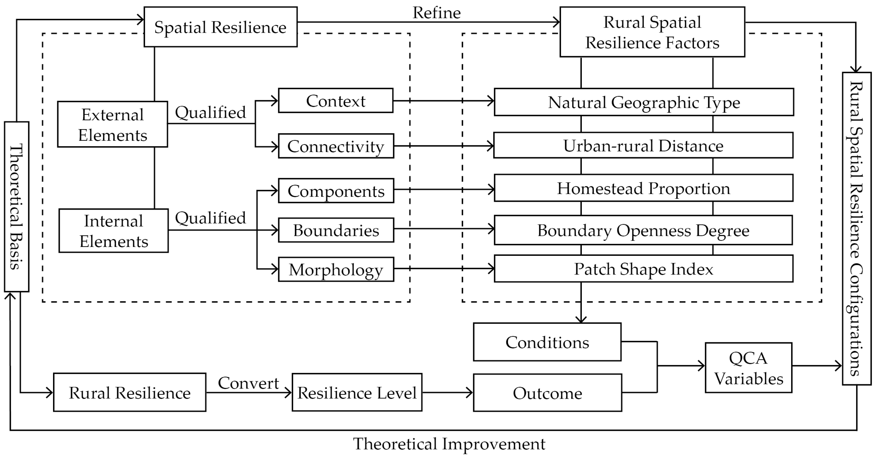
2. Theoretical Background and Relevant Research

The concept of “resilience” has gradually changed and enriched since it was introduced to ecology by Holling from the field of engineering mechanics [28]. It is now defined as a system’s capacity to absorb disturbances and reorganize while undergoing change so as to retain essentially the same function, structure, identity, and feedback [29]. Resilience is an appropriate concept for understanding the vulnerability, response, and adaptive capacity of systems [30]. Resilience focuses on system identity, and resilience equates to the maintenance of key components and relationships and the continuity of these aspects over time [31]. When discussing resilience, it is inevitable that the concept of a system is involved because the concept of resilience was introduced and developed to address the complexity of systems [32,33]. It is worth noting that in the domain of complex systems, many terminologies and even definitions of systems currently lack a widely acknowledged and distinct consensus. As a result, this essay does not explore this issue in great detail, instead adhering to the definitions that are pertinent to the definitions from spatial resilience theory: A system is composed of a set of elements that interact with one another in a shared environment, and its description concerns these components and the relationships between them [31,34]. Therefore, interrelated rural spatial elements can constitute a rural spatial system.
The rural spatial system has multi-scale, multi-level, and multi-type characteristics. Corresponding to the structure of the system, spatial resilience can be categorized into different tiers [24,34]. The description of a system is often contextualized within a specific problem framework [35]. As a result, the choice of which dimension of resilience to investigate can be guided by the particular research question being explored.
In summary, rural spatial resilience serves as a comprehensive attribute that reflects the state of a rural spatial system, offering a perspective from which to investigate the resilience characteristics of such systems. In this regard, the existing research focuses on two fields: spatial resilience and rural resilience. To offer a theoretical foundation for factor extraction and subsequent analysis, both will be described in more detail below in an attempt to unify these two domains, aiming to offer a theoretical foundation for factor extraction and subsequent analysis.

2.1. Spatial Resilience Theory and Its Application

The initial research on spatial resilience focused on human-activity-based disturbances of coral reefs [36]. Subsequently, the definition of spatial resilience gradually developed. Building upon previous research, Cumming systematically constructed a research framework for spatial resilience and defined it as follows: spatial resilience refers to the ways in which spatial variation in relevant variables, both inside and outside the system of interest, influences (and is influenced by) system resilience across multiple spatial and temporal scales [34]. The term “system” above can refer to ecological systems, social systems, or interconnected social–ecological systems [37]. The theory of spatial resilience is fundamentally about the issue of human–nature interactions, conceptualizing and framing these interactions as coherent elements within spatially located components, flows, interactions, and perturbations, thereby constituting a process that is crucial for achieving effective interdisciplinary integration [38]. Following the establishment of this theory, the pertinent research has included the exploration of spatial structures within agricultural landscapes to enhance crop resistance [39], the application of spatial resilience in the context of planning and urban transformation strategies [40], and the combination of spatial resilience with spatial morphology to investigate the impact of urban space and its constituent elements [41], thus assisting planners, designers, and policy decision makers in creating “resilience places” [42] and increasing “physical resilience” [43] at the practical level. In summary, spatial resilience provides operability and quantitative approaches to resilience theory, allowing it to support sustainable development strategies and spatial planning. It is evident that current research mainly focuses on cities, with a noticeable lack of attention towards spatial resilience in rural areas.

2.2. Rural Resilience Theory

As rural decline becomes a global issue, research on rural areas has increasingly focused on survival and sustainability, that is, “how to live and let live” [44]. Rural resilience can be understood as the ability of a system to respond to change and shocks [45]. Due to different emphases, research on rural resilience primarily focuses on three domains: natural ecology, social life, and economic production in rural areas [46]. Rural resilience can be characterized as a process with nonlinear interactions between rural economic, social, environmental, and institutional subsystems given the complex constitution of rural communities, involving resistance, adaptation, and transformation [47]. Due to its non-linear characteristics, measuring rural resilience is a challenging task. Certain scholars have reflected on the process of resilience by measuring changes in data before and after a shock [48,49]. Others have measured it through the perspectives of local residents, management staff, and experts [50,51]. Additionally, indicator systems are constructed to assess resilience levels [52,53]. Overall, conducting resilience-level studies tailored to the specific characteristics of different environments or cases has become a commonly used approach.

2.3. The Interrelation of Theories and the Introduction of Rural Spatial Resilience

While research on resilience has undergone multidimensional and interdisciplinary development, it remains a “fuzzy and contested” concept, lacking consensus regarding its characteristics, measurement, and other aspects [54]. Therefore, the key aspect concerns the resilience “of what” and “to what” [25]. Spatial resilience and rural resilience are both branches in the development of resilience theory. While they exist in different dimensions, they can both be applied to the study of a wide range of rural contexts. As a subset of the broader concept of resilience, spatial resilience concerns the exploration of the question of how space, or, more accurately, spatial variation, influences and is influenced by complex systems [34]. Rural resilience, on the other hand, is directed towards rural regions and typically examines the integrated manifestations and mechanisms of resilience within the rural scope. It distinguishes itself from urban resilience via the distinctive geographic attributes inherent to the rural context [55]. This paper delves into rural spatial resilience, with a central focus on the factors and mechanisms of spatial resilience in rural areas. Inevitably, this exploration involves referencing the application of rural resilience. Consequently, the concept of rural spatial resilience is introduced, which is juxtaposed with the existing research on urban spatial resilience [56,57].
This study defines rural spatial resilience as the ability of rural systems to maintain robustness and adapt to new environments through the combination and interaction of spatial factors. These spatial factors are interconnected and, together with other factors within the rural system (such as social, economic, and ecological factors), form a buffer against risks. Exploring spatial patterns that may be associated with resilience is a necessary step in assessing spatial resilience [25]. Therefore, the initial step involves integrating relevant analytical methods to extract pivotal factors within this framework and elucidate the interrelations between these factors.

3. Methodology

3.1. Research Methods

Qualitative comparative analysis (QCA) is a research method based on set relations [58]. Since its emergence in the late 1980s [59], the application of this method has expanded from the field of political science to encompass the entire field of sociology and even the natural sciences [60]. QCA is designed to combine techniques from qualitative and quantitative approaches [61]. The distinctive feature of this approach is conducting analysis “by case” and not “by variable” [62], and such analysis is combined with quantitative empirical testing, as sufficient and necessary conditions identify outcomes through statistical methods [63,64]. In the configurational perspective, multiple causal factors are interdependent and can achieve a common outcome through differentiated combinations [65].
The set relation explored in QCA refers to sufficiency and necessity, which are expressed as an asymmetry between conditions and outcomes. As a subset of resilience, when investigating spatial resilience’s impact on resilience outcomes, it is prudent to treat spatial resilience factors as constituting a sufficient condition to explore (while also verifying their necessity). Simply stated, certain combinations of spatial factors can lead to a specific resilience outcome, yet a single resilience outcome may correspond to multiple combinations of spatial factors. This asymmetry generates an underlying disparity [66], which is often speculated to be one of the origins of the complexity of a system. Consequently, QCA analyzes the complex causality hidden behind phenomena and is geared towards the study of explicit connections [67]. QCA enables the exploration of the diverse ways in which various conditions differ from a limited number of cases. It offers the possibility of comprehensive micro-level comparisons among a small number of cases within a specific region. Investigating resilience factors at the village level holds a natural advantage in terms of scale [22]. Thus, QCA is both applicable to and advantageous for comprehending the nonlinear complexities associated with spatial resilience at the village scale.
The core steps of QCA involve employing Boolean computation to identify set relations between conditions and outcomes. This task encompasses calculating the configurations of condition variables within cases. QCA identifies the most fitting typical cases for a configuration along with the extent to which these cases adhere to the set relation [62]. This thereby enhances the rigor and scientific nature of qualitative research. Fundamentally, QCA remains a qualitative method because its analytical process relies on the researcher’s familiarity with cases and involves selecting appropriate thresholds to ensure a true reflection of case realities [68,69].
Fuzzy-set Qualitative Comparative Analysis (fsQCA) is an extension of the QCA method that enables researchers to analyze cases where conditions might not be fully present or absent but instead exist in varying degrees [68,69]. Unlike the “presence” and “absence” of conditions in the traditional set relations, fsQCA refines and quantifies these relationships, rendering this method particularly suitable for analyzing complex phenomena. Scholars have explored the influencing factors of rural resilience using fsQCA, for which the primary aim has been the enhancement of resilience in traditional villages [27,46]. In order to uncover the spatial resilience factors in rural areas that have been overlooked in previous research, this study leverages the distinctive features of fsQCA. Accordingly, multiple spatial indicators were compared between traditional villages and other villages, aiming to identify a broader range of spatial resilience factors in rural regions.

3.2. Study Area and Data Source

The scope of this study encompasses southern Jiangsu, i.e., the southern part of Jiangsu Province, China (Figure 1). This region extends between latitude 30°45′ and 32°35′ N and longitude 118°22′ to 121°21′ E. Administratively, southern Jiangsu includes five cities: Nanjing, Zhenjiang, Suzhou, Wuxi, and Changzhou. Southern Jiangsu covers an area of approximately 28,085 km2, which accounts for 26.21% of the total area of Jiangsu Province. This region is characterized by its gentle terrain, which predominantly consists of plains and hills. It is rich in water resources, containing rivers, canals, and lakes. With its favorable climate and geographical conditions, southern Jiangsu is a historically significant area for human settlements, and it has developed unique and distinctive rural settlements over time. This study area is the core area of the Yangtze River Delta city cluster and accounts for a significant share of the economic and social development of Jiangsu Province. It consistently assumes a pioneering role in rural development across the nation. According to previous research findings, rural evolution in southern Jiangsu has demonstrated a sustainable trend, surpassing that of other areas within the province and even the broader area in China [70,71,72]. Therefore, the study of rural spatial resilience in this region also has important implications for rural areas in other regions.
The determination of the threshold of spatial resilience and its corresponding adaptive states requires dynamic data of various temporal and spatial dimensions [25]. However, obtaining such data poses significant challenges. To accurately depict the characteristics of resilience, a comparative study was conducted on villages constructed in different periods. The selected villages represent diverse system states within the database corresponding to various stages of development. Furthermore, to adhere to the principle of maximizing heterogeneity in the case selection of QCA analysis [73], 21 natural villages in southern Jiangsu, serving as empirical cases, were selected in this research (Figure 2 and Table A1). These villages exhibit distinct geographical environments, urban–rural distances, and spatial patterns, thus effectively representing the diversity of rural conditions in the region.
The data utilized in this study comprise literature data, local statistical data, and image information data. The macro-level data include open data such as satellite images, elevation data, and land use data. Due to the absence of village-level data in the government’s official statistics, the micro-level data pertaining to village population, homesteads, and construction land in this study primarily stem from on–site investigations and interviews conducted with village officials and residents since 2017. To ensure data accuracy, cross–referencing and validation were conducted by comparing the collected data with the existing literature [74,75], planning documents, and satellite images. Subsequent verification and corrections were then applied as needed.

3.3. Variable Selection

3.3.1. Selection Basis

Based on the five most commonly used methods for selecting conditional variables in QCA [73], this study primarily employs a comprehensive approach that combines the theoretical perspective method, the problem-oriented method, and the phenomenon summary method. The theoretical perspective employed in this study originates from the relevant elements of spatial resilience delineated by Cumming G. S. et al. [34,38]. They consider spatial resilience to be the spatial arrangement of, the differences in, and the interactions between the internal and external elements of a system. Spatial resilience can thus be divided into external elements (i.e., those outside the focal system), internal elements (i.e., those within the focal system), and other spatially relevant aspects of resilience. According to the further refinement carried out by Allen C. R. et al. [25], certain internal features (including the arrangement of system components (e.g., patch arrangement)), their morphologies and system boundaries, and external components such as context can be readily assessed with remote sensing and GIS techniques. Specifically, the categorizations of “internal” and “external” can be defined not only in social, economic, and ecological dimensions but also through delineations based on geographical boundaries.
To ensure practicality when measuring spatial resilience, it is advised that the scale of variables is narrowed down, incorporating mapping and substitution methods to ensure that variables are “tractable” [34]. Because of a requisite level of simplicity behind the complexity, a system can be described in terms of three to five key variables, constituting a principle known as the “rule of hand” [24]. Therefore, in the study of spatial resilience factors, it is possible to select a minimal set of relevant spatial variables to construct a model [34]. Furthermore, based on a deeper understanding of the research question and observations of the phenomenon, relevant resilience factors associated with rural spatial systems can be extracted. These factors should not only match the requirements of QCA analysis but also accurately align with the specific objectives of a study, ensuring a precise and tailored description of rural spatial systems.
In the context of external aspects, an analysis should focus on the most prominent factors that significantly influence a system. Context serves as both a source of system shocks and as a resource for materials that can be utilized in response to pressures, such as natural capital, human-made environmental capital, economic capital, etc. [76]. Connectivity represents the level of information exchange with the external environment, which has both advantages and disadvantages for resilience. Building upon the previously mentioned points, a system is composed of a set of interconnected elements. Regarding the internal aspects of a spatial system, the initial step involves delineating the boundaries that distinguish its internal and external domains. Subsequently, attention shifts to components and morphology alongside the resultant network structure that emerges from their interplay. Boundaries affect both internal and external exchanges, providing a buffer against shocks. The composition ratios of various components determine the flexibility of spatial properties. Additionally, morphological factors such as patch shapes have an impact on crucial processes or interactions [34]. In contrast to urban areas, rural regions exhibit simplified patterns of land use and transportation organization, thus rendering their network structures less complex than those of cities. Based on field investigations, this study posits that rural transportation organization is more reliant upon accessible paths, including public and even private domains. As a result, a combination of cluster shapes and boundary openness is proposed as an expression of the internal network structures that are applicable to rural spaces. In summary, within the framework of spatial resilience, this study employed a simplified system description approach. The selected spatial factors for rural southern Jiangsu encompass external factors, including natural geographical types and urban–rural distances, as well as internal factors including homestead proportions, boundary openness, and patch shape indices. Subsequent sections will provide detailed sub-item descriptions of each indicator.
As for the outcome variables, according to the theory of spatial resilience, indicators that influence the persistence of systems in space, such as spatial heterogeneity, fragmentation, and cross-scale structure, can serve as resilience metrics [34,77,78]. Therefore, the persistence of spatial systems can be considered a direct and explicit indicator for measuring resilience. Due to the difficulty of measurement, this study employed the indicator substitution approach mentioned above. Similarly, detailed elucidations of the outcome variables will be provided in the subsequent sections.

3.3.2. Conditional Variable Description

Summarizing the above (Figure 3), representative factors from the internal and external elements of spatial resilience suitable for rural areas in southern Jiangsu were selected as conditional variables. In accordance with the principles of QCA, the 5 condition variables yielded 25 potential combinations (32 possibilities), suggesting that the recommended number of cases should exceed 15 [79]. The number of cases in this study is 21, which satisfies the required quantity. These factors include the natural geographic environment, rural–urban distance, homestead proportion, boundary openness, and patch shape index.
  • Natural geographic type (NGT)
Due to the overall similarity of the climate in the different regions in southern Jiangsu Province, the natural geographic types to which villages belong have been selected as the primary environmental factors. Based on topography, landforms, hydrological characteristics, and their suitability for village studies, cases have been categorized into five geographic types (Figure 4) [75]. To facilitate a clearer comparison, the village density per square meter was calculated for each type, with values ranging from 1 to 5 being assigned in ascending order, as follows: mountainous areas, hilly lands, plains, lake areas, and enclosed basins.
  • Rural–urban distance (RUD)
The gradient from urban to rural represents the socio-economic asymmetries, and it also drives processes in social–ecological systems [25]. The development of cities undoubtedly has an impact on the resilience of rural areas. Therefore, this study considers the physical distance between villages and towns as an external environmental factor that influences rural spatial resilience.
  • Homestead proportion (HP)
China’s long-standing land policy stipulates that the use of homesteads1 in villages is primarily limited to local farmers and that they are strictly prohibited from buying and selling this property. Compared to other types of land used for construction purposes, the proportion of homestead land can reflect the internal structural stability of a village to a certain extent. The corresponding calculation formula is as follows:
H P = s × n C
In Formula (1), “s” is the per capita (per household) area of homestead land, “n” is population (number of households), and “ C ” is the total area of construction land in the village.
  • Boundary openness degree (BOD)
The stability of a system can be influenced by edge effects [25]. The boundaries of a village consist of the combination of its physical structures and the gaps in between, serving as crucial factors for delineating the inside and outside of the village. The gap components are the first to experience external impacts and are more susceptible to change. Consequently, the parameter of boundary openness, which denotes the ratio of interstices to the entire perimeter of the boundary, serves as an external factor (Figure 5a).
  • Patch shape index (PSI)
Rural spaces are composed of interconnected clusters of varying shapes, and the morphological changes in rural spaces are accompanied by an increase or decrease in these clusters. The patch shape index is typically a mathematical transformation of the ratio between the perimeter and area of a patch. It quantifies the level of shape complexity via measuring the deviation between the shape of a patch and a circle or square with the same area [80]. The greater the complexity or elongation of a patch, the higher the PSI value. In Figure 5b, the darker the color, the higher the shape index and the more obvious the striped feature. While the PSI itself lacks practical significance, when applied in the context of rural environments, it can, to a certain extent, reveal the spatial patterns within such environments. For the purpose of comparative analysis, the average PSI was calculated as follows:
PSI = 1 m k = 1 m 0.25 E k A k
In Formula (2), “m” is the number of clusters, “Ek” is the perimeter of the cluster k, and “Ak” is the area of the cluster k.

3.3.3. Outcome Variable Description

There are two approaches to assessing spatial resilience: direct and indirect methods [26]. The direct measurement of resilience treats resilience as a concrete entity and involves understanding factors such as a system’s response to stressors and recovery time thresholds [81]. However, in the case of rural human habitats, which are complex adaptive systems with dynamic multidimensional characteristics, direct measurement becomes challenging to implement. Therefore, indirect measurement methods are typically employed, which involve transforming resilience into non-tangible objects and conducting an indirect evaluation of system resilience through the construction of evaluation systems and analytical frameworks [82]. It is worth clarifying that scholars have defined attributes and assessment methods related to rural resilience based on specific cases and their contexts. These definitions have clear applicability within specific scopes. Therefore, understanding the social, economic, environmental, and institutional composition of a study area’s location is crucial [24].
The selection of the outcome variables in this study was firstly based on the original logic of resilience measurement, where the degree of completeness of villages in their historical evolution represents the loss of resilience. Therefore, the duration of village establishment, or spatial persistence, can be used as a measure of an area’s resilience level. However, the village annals are incomplete, making it impossible to determine the exact time when the village was established. Furthermore, the construction years of individual buildings are insufficient for representing the entire village.
Considering the scope of resilience assessment discussed earlier, this study refers to the official lists of Chinese Historical and Cultural Villages2 and Characteristic Pastoral Countryside3 in Jiangsu as the basis for the resilience levels. Firstly, the listed villages have long histories. Secondly, the criteria for the selection of these listings emphasize various aspects such as the historical and cultural value of the villages, their integrity, social engagement, and architectural preservation. Finally, existing research has demonstrated that inclusion in such listings, coupled with appropriate protection and development policies, can encourage villages to proactively adapt and provides them with multiple avenues with which to enhance their resilience [83]. Therefore, these villages are regarded as having higher levels of resilience, and the Chinese Historical and Cultural Villages included in the law have the highest resilience levels. Consequently, based on the construction times, villages that have been newly constructed or that have undergone significant changes in land use within the past 20 years are considered to have relatively lower resilience. The remaining common villages are categorized as moderate resilience-level cases. In summary, this study classified four resilience levels through equivalent substitution and assigned values of 1–4 to each level (Table 1), serving as the outcome variables for the four-value fuzzy set applied in the fsQCA.

3.4. Variable Calibration

Our analysis was conducted using fsQCA 4.0 software. Variable calibration is a regular step in this analysis, for which the aim is the classification of variables into the dependency relations of the fuzzy sets. Based on the data type and standard procedures of fsQCA, three calibration methods are determined by considering the specific circumstances of the cases. Descriptions of the indicators for each condition variable and the calibration anchors are provided in Table 1 and Table 2.

4. Results

4.1. Necessity Analysis

The first step in our study was the necessity analysis. If the consistency value is greater than 0.9, it indicates the presence of necessary conditions for the outcome. After performing the necessity analysis using the previously specified software, no necessary conditions were identified. This result implies that a single condition alone does not necessarily lead to the outcome in question (Table 3).

4.2. Calculation Results

The presentation of the results (Table 4) follows the common format of fsQCA, revealing four configurations that are related to rural spatial resilience along with the core conditions and marginal conditions [84]. The core conditions exhibit a strong association with the outcome as they are present in both the intermediate solutions and simplified solutions. On the other hand, the marginal conditions show a weaker association with the outcome as they only appear in the intermediate solutions. It is also possible for a configuration in the results to have multiple combinations of core conditions, which is permitted [61]. Further discussion on this matter will be provided in the subsequent sections.
As shown in the table, the consistency of the solutions exceeds 0.75, thus satisfying the recommended criteria for sufficiency [49]. This means that among all the cases that satisfy these four configurations, 83.11% of the villages demonstrated a higher level of resilience. Therefore, these configurations can be considered sufficient condition combinations for high resilience in southern Jiangsu. The coverage of the solutions indicates that these four configurations can explain 62.15% of the village cases. The consistency level of each configuration represents the likelihood of villages possessing a particular configuration that gives rise to a high level of resilience. The original coverage denotes the proportion of high-resilience villages that can be explained by a given configuration. The unique coverage indicates the proportion of cases that can only be explained by a specific configuration.
  • Configuration 1: Predominance of internal factors.
This configuration indicates that, for villages in close proximity to towns and those with a predominantly square-shaped clustering, there is a higher proportion of residential land and that open boundaries can lead to a higher level of resilience. This configuration is primarily influenced by internal factors (with external factors only serving as marginal conditions) and can explain 34.76% of the cases, with 10.04% of the cases being exclusively explained by this configuration. In this configuration, the spatial resilience mainly arises from the stability of the spatial structure of the villages.
  • Configuration 2: Substitution of internal and external factors.
This configuration suggests that resilient villages that are located in high-density areas (such as enclosed basins, lake areas, and plains) and those that are in close proximity to towns often exhibit a high level of boundary openness. This combination forms the core conditions. On the other hand, similar to Configuration 1, the desired resilience level can also be achieved through the combination of two internal conditions. Configuration 2 has two combinations of core conditions, thereby demonstrating a substitutive relationship between the internal and external factors as core conditions. This can explain 26.87% of the cases, while 4.38% of the cases are exclusively explained by this configuration. This configuration represents a category of villages located near towns that possess the ability to maintain balance during the transformation of urban–rural relationships. This ability is derived from open boundaries that can accommodate diverse functional inputs coupled with the difficulty of land-use changes, resulting in a balanced interplay between adaptation and stability.
  • Configuration 3: Predominance of external factors.
This configuration reveals that in geographic regions characterized by low village density (such as mountains areas and hilly lands), high-resilience villages are more likely to be located far from towns. These villages are accompanied by higher boundary openness and elongated clustering patterns. When the natural geographic type, proportion of residential land, and boundary openness simultaneously serve as core conditions, the unique coverage is 0 (but only in simple solutions). This finding indicates that no case can be exclusively explained by this combination, suggesting the presence of cross-coverage between the configurations. We have refrained from further in-depth discussion of configuration 3b. Therefore, Configuration 3 is considered to mainly reflect the scenario where external factors serve as the core conditions. This configuration can explain 30.04% of the cases, with 16.39% of the cases being exclusively explained by this configuration. Therefore, this configuration represents a category of villages situated in remote areas that have remained relatively unaffected. External factors enable them to maintain their current state and resilience.
  • Configuration 4: Collaboration between internal and external factors.
This configuration indicates that when villages are situated in low-density geographic regions, their spatial stability is primarily governed by the proportion of homesteads. Additionally, the villages should have favorable location conditions near towns, higher boundary openness, and elongated clustering patterns. This configuration is driven by the collaboration of internal and external factors. It can explain 19.91% of the cases, with 4.98% of the cases being exclusively explained by this configuration. The spatial resilience of the villages in this configuration arises from a combination of internal and external factors, reflecting the intricate mechanisms of resilience. This finding underscores the necessity of coordinating multiple factors to achieve a balance of resilience.
In conclusion, the results of this analysis comprehensively cover the internal and external factors of spatial resilience, reflecting the rationality of variable selection from an empirical perspective. The subsequent sections will delve into the specific cases within each configuration, providing a more in-depth exploration of their formation and mechanisms.

4.3. Robustness Check

Generally, three kinds of robustness analysis are employed in fsQCA: changing calibration, changing consistency levels, and dropping or adding cases. The latter two methods are suitable for studies with large sample sizes [85]. Therefore, based on the number of cases in this study, different calibration anchors (0.75, 0.5, and 0.25) were chosen for robustness verification. The configuration results remained substantively unchanged. The robustness checks indicated that the analysis was not highly sensitive to the specification of these thresholds.

5. Discussion

5.1. The Differential Synergistic Relationships between Rural Resilience Factors

From a conditional perspective, the five resilience factors exist in the form of core or marginal conditions across the four configurations, thus verifying their multiple coordinated roles in resilience. Additionally, there is a substitutive relationship among the variables, indicating that rural spatial resilience can be developed through various means. For instance, when comparing Configuration 1 and Configuration 4 (which both involve villages on the outskirts of towns), it was observed that if the villages are situated in mountainous or hilly areas, the optimal configuration for enhancing resilience is a high proportion of homesteads. However, it is also possible to achieve the same outcome via a synergistic effect by considering both the homestead proportion and the boundary openness degree. This demonstrates that different pathways can lead to the same goal, highlighting the concept of “different paths, same destination” in relation to enhancing resilience.
Moreover, the differential synergistic relationships between internal and external factors in relation to sustaining the spatial resilience of villages can be identified. The combination of two external factors as core conditions (Configuration 3) indicates that external conditions serve as the foundation and source of system resilience. In all configurations, internal factors appear in combinations of two, thus describing the collaborative mechanisms of the internal factors. Among the internal factors, a high proportion of homesteads was identified as a core condition in three configurations (Configurations 1, 2, and 4), thereby indicating that this factor plays a crucial role in maintaining the stability of rural spatial systems to a certain extent. A high degree of boundary openness is another important internal factor, occupying a core position in two of the configurations (Configurations 1 and 2). This result highlights that enhancing the permeability of boundaries makes a system more flexible with respect to adapting to changes without compromising its overall structural stability. Moreover, each configuration encompasses a boundary openness degree (substantiating the role of boundaries as junctures of human and natural interactions), thereby playing a crucial role in the establishment of spatial resilience. The shape index predominantly appears as marginal conditions, indicating that, in the selected cases, there were no strong associations between the shape features and resilience. In most cases, a higher level of resilience derived from a synergistic interaction between internal and external factors, and this result aligns with the related assertions in spatial resilience theory.
For southern Jiangsu, areas such as plains, lake areas, and enclosed basins that are more accessible to construction resources do not necessarily exhibit significant resilience advantages. Furthermore, when these areas appear as the core condition, they are associated with being distant from urban areas. This may be due to the impact of urbanization processes in these regions, reflecting the urban–rural relationships in this region.

5.2. Selection and Analysis of Typical Cases

From a case-based perspective, Table 5 illustrates the explanatory cases that correspond to the four configurations. From the perspective of administrative regional distribution, they are relatively evenly distributed among the five cities in southern Jiangsu Province (three in Nanjing, two in Zhenjiang, two in Suzhou, three in Wuxi, and one in Changzhou). Following the general procedure of fsQCA, the selection criterion for typical cases is that the outcome relevance should be higher than the configuration relevance. Therefore, based on this criterion, six Chinese historical and cultural villages and two other villages (Changle and Qianyuan) were initially chosen. However, one of the objectives of this study is to identify common villages with the same combination of resilience factors as the historical villages; accordingly, the outcome relevance of the village needs to be less than the configuration relevance. Hence, considering resilience levels, spatial distribution, and practical case considerations, Shi’ao (No.2), Jiaoxi (No.21), Wutang (No.8), and Qianyuan (No.18) were selected as typical cases with which to further clarify the mechanisms of each configuration.
Typical case of Configuration 1: Shi’ao Village is situated within the Niushou’shan Scenic Area near Nanjing city (Figure 2, Table A1). Since 2011, this village has undergone a holistic transformation into a tourism-oriented village. Hence, this article categorizes it as a newly established village. This village exhibits the resilience factors defined in Configuration 1, where a high proportion of homesteads and open boundaries serve as core conditions, while proximity to the town and a regular clustering form act as marginal conditions. Based on field surveys and observations, the high proportion of homesteads enables this village to undergo functional changes, which offers the possibility of shifting the function of rural dwellings from residences to a combination of residences and businesses. Additionally, the village’s highly open boundaries, which are concentrated primarily in the southern part of the village for topographical reasons, coincide with the entrance to the scenic area. This facilitates transportation connectivity and visual corridors both internally and externally. Huashan (No. 10) and Shecun (No. 3) in this configuration also have similar situations. She Village, in particular, has become a popular village driven by tourism projects that has perfected the construction of spatial resilience and completed the transformation of functions.
Typical case of Configuration 2: Jiaoxi Village, established around 810 A.D., is located in a flatland area and in close proximity to a nearby town (Figure 2, Table A1). The village has a long history of market trade, spanning nearly a century, and has primarily served residential and commercial purposes. Since the 1980s, its commercial activities gradually shifted westward, leading to the development of a larger market town. As a result, Jiaoxi Village has predominantly retained its residential function. The open boundaries of this village are primarily situated in the western and southeastern regions, thereby facilitating connectivity with the market town and the agricultural fields along the river. Despite facing impacts from the adjacent market town, the highly open boundaries actually provide greater opportunities for connectivity, mitigating impacts and preserving the overall village layout. Furthermore, from a spatial layout perspective, the loose structure at the boundaries of the village and the high density in its central area contribute to the stability of this village’s structure. The villages in this configuration maintain a delicate equilibrium with respect to suburban characteristics, which can be attributed to their historical and cultural significance and architectural heritage. Revitalizing the surrounding village environment around rural heritage [86] could be a pivotal strategy for enhancing resilience.
Typical case of Configuration 3: Wutang Village is a hilly village in southern Jiangsu named after its five internal water ponds (Figure 2, Table A1). This village is nestled among mountains and water. Based on Configuration 3, it is equally evident that the dominant factor of this village is the natural geographical environment in which it is situated. This is due to the village’s remote distance from the nearest city, which has allowed it to retain its traditional agricultural village layout. Within this configuration, Changle (No. 6) shares similarities with Wutang Village, representing a subset of villages in close proximity to the city that remains unaffected due to regional geographical conditions. This shows that natural environmental factors could still be a dominant factor of rural spatial resilience.
Typical case of Configuration 4: Qianyuan Village presents the natural geographical type as its core resilience factor. Its elongated cluster shape and open boundaries enable this village to better adapt to the natural environment. Similarly, as a typical mountain village, it is located near tea plantations and extensive forests (Figure 2, Table A1), with agriculture being the primary industry. Mountainous regions impose more challenging construction conditions; therefore, the configuration of their resilience factors is more diverse, but it mainly revolves around the natural geographical conditions, which are complemented by a higher proportion of homesteads. This introduces a higher degree of spatial heterogeneity. This spatial heterogeneity brings about driving forces, leading to a moderate equilibrium of resilience within the spatial system. It also embodies the relationship between humans and nature in terms of spatial resilience. Sustaining its existing spatial pattern while minimizing extensive spatial alterations proves to be an appropriate approach to maintaining balance among the factors.
After separately illustrating the mechanisms of configurations for the cases and then comprehensively comparing the differences between the configurations and between the cases, further discussion can be carried out in relation to the following three aspects. Firstly, the relationship between resilience and tourism deserves attention, as it involves the functional transformation of villages. The cases within Configurations 1 and 3, which encompass numerous tourism-oriented villages, demonstrate that the functional transition from agriculture to tourism is a highly resilient approach [87]. Furthermore, the presence and absence of urban–rural distances in the two configurations indicate that urban–rural distance is not a predominant factor influencing the spatial resilience of tourism-oriented villages, and this result aligns with the findings of existing research [88]. The core factors in Configuration 1 are internal, whereas they are external in Configuration 3. This demonstrates that the driving force behind the transformation of tourism functions originates from different aspects. It is essential to plan the direction of transformation based on the respective dominant resilience factors. The second aspect is about the spatial operation of rural revitalization. Spatial resilience theory holds the potential to serve as a management paradigm, but its challenge lies in the gaps of spatial resilience discourse and practice [89]. Through our discussion of the mechanisms of the configurations with respect to the case villages, it is evident that spatial resilience could furnish both a theoretical framework and practical foundation for rural development. Finally, the manifestation of urban–rural relationships at the spatial resilience level is noteworthy. Each configuration includes urban–rural distance as a condition, and it is evident that most resilience factors in multiple configurations relate to being located far from urban areas (with the exception of Configuration 3). This observation suggests that the impact of urbanization on rural southern Jiangsu is often negative. This eventuality could be an inevitable result of urbanization, but through the examples of Jiaoxi and Wutang, it might provide inspiration for rural sustainable development in the future.

6. Conclusions

With the complex issues facing the rural built environment in China, spatial resilience theory offers a novel perspective. Applying the concept of resilience at the spatial dimension enhances the feasibility of practical activities for planners and developers in the realms of planning and construction. This paper, operating within the framework of spatial resilience theory, elaborates on the application of spatial resilience in the rural built environment. It introduces an experimental analytical framework for the theory. Employing fsQCA, this study selected 21 representative villages in southern Jiangsu that presented different resilience conditions. Four configurations of factors that affect the level of rural spatial resilience were identified, leading to the identification of the mechanisms behind these factors. In terms of set relations, the absence of necessary conditions suggests, to a certain extent, that rural spatial resilience is not solely associated with a single factor. Instead, it is the optimization and combination of multiple sufficient conditions that collectively form a stable and sustainable rural spatial system. Subsequently, through the calculation of set relations, configurations, the sufficiency of factors, and corresponding exemplary cases were identified. From an empirical perspective, this study explores the synergistic patterns of multiple internal and external factors within the framework of spatial resilience at the village level. At meso and micro scales, the interpretation of how spatial factors influence rural resilience was examined. Mixed research methods were explored, leading to an enrichment of our understanding of rural spatial resilience.
The limitations of this study are as follows:
(1)
In an effort to provide a reference for rural built environments, this study embarked on an initial exploration of rural spatial resilience. The assessment of resilience levels employed a relatively simplified approach relying on government regulations, policy, and their underlying selection criteria to establish four levels. Given the multi-dimensional nature of rural resilience, a comprehensive study would ideally require the evaluation of indicators across various (e.g., social, economic, and ecological) dimensions [53,90,91,92].
(2)
Constrained by the limited number of cases, the five conditional variables could only partially elucidate the relationship between spatial elements and rural resilience. While our analysis demonstrated the coverage of the conditional variables’ configurations, there is still potential for further factor augmentation.
(3)
Although QCA is a method that can be used to explore complex relationships, it suffers from limitations in longitudinal studies. Although this study attempted to compensate for these limitations by including villages from different developmental periods as a proxy for temporal dynamics, there is still a lack of explanatory power in the concept of spatial resilience.
Therefore, in future research, further advancements will be made in relation to the following aspects:
(1)
Future studies will provide a comprehensive evaluation of rural resilience by incorporating a more extensive set of systematic indicators within the framework of the social–ecological system [93,94].
(2)
Exploring factors that can provide a more comprehensive depiction of rural spatial resilience involves identifying factors that encompass a broader scope, which will be carried out in future research. Additionally, to account for the proportionality between conditions and case numbers, future studies will increase the quantity of empirical case villages.
(3)
In future studies, historical data on villages will be gathered, and other research methods (e.g., comparative analysis of multiple panel data) will be incorporated as supplementary approaches to address the issue of longitudinal analysis.
Based on the research findings, three further recommendations are proposed for developing resilient villages:
(1)
Adopting a holistic and resilient perspective: given the mechanisms for collaboration between the factors of rural spatial resilience, practitioners can adopt a holistic perspective and foster synergistic cooperation between various spatial factors to achieve efficient resilience development.
(2)
Focus on core factors: the decision makers and stakeholders involved in rural development can prioritize the core factors that are based on the unique resources and characteristics of each village by focusing efforts on strengthening these core factors for a more efficient and sustainable path.
(3)
Identifying potential development cases: the methodology employed in this study can be applied to identify potential development cases with high-resilience factors in common villages.
Overall, these recommendations aim to promote a comprehensive and strategic approach to developing resilient rural areas and provide insights and guidance for future rural revitalization.

Author Contributions

Conceptualization, Y.Y. and Y.W.; methodology, Y.Y.; software, Y.Y.; validation, Y.Y. and Y.W.; formal analysis, Y.Y.; investigation, Y.Y. and Y.W.; resources, Y.W.; data curation, Y.Y.; writing—original draft preparation, Y.Y.; writing—review and editing, Y.Y. and Y.W.; visualization, Y.Y.; supervision, Y.W.; project administration, Y.W.; funding acquisition, Y.W. All authors have read and agreed to the published version of the manuscript.

Funding

This research was funded by the National Natural Science Foundation of China under grant number: 52178005.

Data Availability Statement

The data used herein come from the following open sources: the National Platform for Common Geospatial Information (www.tianditu.gov.cn, accessed on 29 May 2023); Geospatial Data Cloud (www.gscloud.cn, accessed on 22 May 2023); and GlobalLand30 (www.globallandcover.com, accessed on 24 May 2023). The data from the mapping bureaus and the survey have been deemed private.

Acknowledgments

Special thanks are given to the anonymous reviewers for their valuable comments.

Conflicts of Interest

The authors declare no conflict of interest. The funders had no role in the design of the study; in the collection, analyses, or interpretation of data; in the writing of the manuscript; or in the decision to publish the results.

Appendix A

Table A1. Satellite views of the 21 villages that were utilized as cases.
CityID&VillageCityID&VillageCityID&Village
NanjingLand 12 01677 i001
1–Yangliu
Zhen-jiangLand 12 01677 i002
8–Wutang
WuxiLand 12 01677 i003
15–Lishe
Land 12 01677 i004
2–Shi’ao
Land 12 01677 i005
9–Sancheng
Land 12 01677 i006
16–Huangni’ba
Land 12 01677 i007
3–Shecun
Land 12 01677 i008
10–Huashan
Land 12 01677 i009
17–Meijia’du
Land 12 01677 i010
4–Qiqiao
SuzhouLand 12 01677 i011
11–Luxiang
Land 12 01677 i012
18–Qianyuan
Land 12 01677 i013
5–Lijia
Land 12 01677 i014
12–Mingyue’wan
Chang-zhouLand 12 01677 i015
19–Nixiang
Land 12 01677 i016
6–Changle
Land 12 01677 i017
13–Kaixian’gong
Land 12 01677 i018
20–Xuetong’wei
Land 12 01677 i019
7–Bulao
Land 12 01677 i020
14–Rizi’wei
Land 12 01677 i021
21-Jiaoxi

Notes

1
The term homesteads refers to the construction land that rural residents use for building houses and their associated facilities, including residences, auxiliary buildings, and courtyards. Under China’s land policy, the ownership of homesteads belongs to the rural collective, while the right of use belongs to individual farmers and can be transferred within the collective but cannot be sold to urban residents. Homesteads also serve as a form of property security for farmers and are an essential foundation for their livelihoods and agricultural production, which both play a crucial role in stabilizing and developing rural areas.
2
Chinese Historical and Cultural Villages are designated jointly by the Ministry of Housing and Urban–Rural Development and the National Cultural Heritage Administration. These villages possess abundant cultural relics and hold significant historical value or commemorative significance. They provide relatively comprehensive representations of traditional styles and local ethnic characteristics from specific historical periods.
3
Characteristic Pastoral Countryside is a rural development action undertaken by the Jiangsu provincial government in 2017. It encompasses various current situations and development types, comprehensively selecting villages with distinctive features for focused development in relation to nine key aspects: industry, ecology, culture, pastoral landscapes, rural architecture, rural lifestyle, beautiful villages, livable villages, and vibrant villages. As of 2022, nearly 600 villages have been selected as pilot projects, and corresponding construction standards have been released.

References

  1. Liu, Y.; Li, Y. Revitalize the world’s countryside. Nature 2017, 548, 275–277. [Google Scholar] [CrossRef]
  2. Li, Y. Urban-rural interaction in China: Historic scenario and assessment. China Agric. Econ. Rev. 2011, 3, 335–349. [Google Scholar] [CrossRef]
  3. Bao, Z.; Zhou, J. Phenomenon, Reasons, and Countermeasures for Contemporary Rural Landscape Decline. City Plan. Rev. 2014, 38, 75–83. [Google Scholar]
  4. Tian, C.; Wu, P. A Review of Rural Ecological Environment Problems Since the Reform and Opening Up. Agric. Econ. 2014, 10, 28–30. [Google Scholar] [CrossRef]
  5. Liu, Y.; Lu, S.; Chen, Y. Spatio-temporal change of urban–rural equalized development patterns in China and its driving factors. J. Rural Stud. 2013, 32, 320–330. [Google Scholar] [CrossRef]
  6. Wen, Q.; Zheng, D.; Shi, L. Themes Evolution of Rural Revitalization and Its Research Prospect in China from 1949 to 2019. Prog. Geogr. 2019, 38, 1272–1281. [Google Scholar] [CrossRef]
  7. Wang, K.; Feng, Y.; Zhang, Y. Development process, logic, and prospect of rural human settlements after reform and opening-up. Urban Plan. Forum 2022, 46, 77–86. [Google Scholar]
  8. Xue, Y.; Mao, K.; Weeks, N.; Xiao, J. Rural reform in contemporary China: Development, efficiency, and fairness. J. Contemp. China 2021, 30, 266–282. [Google Scholar] [CrossRef]
  9. Liu, Y. Research on the urban-rural integration and rural revitalization in the new era in China. Acta Geogr. Sin. 2018, 73, 637–650. [Google Scholar] [CrossRef]
  10. Long, H.; Li, Y.; Liu, Y.; Woods, M.; Zou, J. Accelerated restructuring in rural China fueled by ‘increasing vs. decreasing balance’ land-use policy for dealing with hollowed villages. Land Use Policy 2012, 29, 11–22. [Google Scholar] [CrossRef]
  11. Liu, Y.; Liu, Y.; Chen, Y.; Long, H. The process and driving forces of rural hollowing in China under rapid urbanization. J. Geogr. Sci. 2010, 20, 876–888. [Google Scholar] [CrossRef]
  12. Ye, Q.; Zhong, Z. Have we been ready for rural construction: Research on the theoretical framework of rural construction system. Geogr. Res. 2017, 36, 1843–1858. [Google Scholar]
  13. Xi, J. Full Text of Xi Jinping’s Report at 19th CPC National Congress. Available online: www.xinhuanet.com//english/special/2017-11/03/c_136725942.htm (accessed on 14 August 2023).
  14. Chen, X. Forty years of rural reform in China: Retrospect and future prospects. China Agric. Econ. Rev. 2019, 11, 460–470. [Google Scholar] [CrossRef]
  15. Long, H.; Zhang, Y.; Tu, S. Land consolidation and rural vitalization. Acta Geogr. Sin. 2018, 73, 1837–1849. [Google Scholar]
  16. Liu, Z.; Shen, M.; Zhang, J. Temporary Agent Mode and Corresponding Dilemma Caused by Project System: Based on an Observation of Yangliu Village in Nanjing. Mod. Urban Res. 2018, 119–124, 132. [Google Scholar]
  17. Liu, Y.; Zang, Y.; Yang, Y. China’s rural revitalization and development: Theory, technology and management. J. Geogr. Sci. 2020, 30, 1923–1942. [Google Scholar] [CrossRef]
  18. Chen, C.; Geng, J. Research on the evolution of traditional rural communities from the perspective of resilience-building: The case of three typical villages in moganshan town. City Plan. Rev. 2023, 47, 86–93. [Google Scholar]
  19. Wilson, G. Multifunctional quality and rural community resilience. Trans.—Inst. Br. Geogr. 2010, 35, 364–381. [Google Scholar] [CrossRef]
  20. Salvia, R.; Quaranta, G. Place-Based Rural Development and Resilience: A Lesson from a Small Community. Sustainability 2017, 9, 889. [Google Scholar] [CrossRef]
  21. Heijman, W.; Hagelaar, G.; van der Heide, M. Rural Resilience as a New Development Concept. In EU Bioeconomy Economics and Policies: Volume II; Dries, L., Heijman, W., Jongeneel, R., Purnhagen, K., Wesseler, J., Eds.; Springer International Publishing: Cham, Switzerland, 2019; pp. 195–211. ISBN 978-3-030-28642-2. [Google Scholar]
  22. Li, H. Rural settlements research from the perspective of resilience theory. Sci. Geogr. Sin. 2020, 40, 556–562. [Google Scholar]
  23. Ma, L.; Tao, T.; Li, Z.; Wu, S.; Zhang, W. Study on spatial divergence of rural resilience and optimal governance paths in oasis: The case of Yongchang County in the Hexi Corridor of China. Environ. Dev. Sustain. 2023, 1–25. [Google Scholar] [CrossRef]
  24. Holling, C.S. Understanding the Complexity of Economic, Ecological, and Social Systems. Ecosystems 2001, 4, 390–405. [Google Scholar] [CrossRef]
  25. Allen, C.R.; Angeler, D.G.; Cumming, G.S.; Folke, C.; Twidwell, D.; Uden, D.R. Quantifying spatial resilience. J. Appl. Ecol. 2016, 53, 625–635. [Google Scholar] [CrossRef]
  26. Lu, Y.; Zhai, G. Research Progress and Perspectives on the Theory and Practice of Urban Spatial Resilience. Shanghai Urban Plan. Rev. 2022, 6, 1–7. [Google Scholar] [CrossRef]
  27. Yang, M.; Jiao, M.; Zhang, J. Spatio-Temporal Analysis and Influencing Factors of Rural Resilience from the Perspective of Sustainable Rural Development. Int. J. Environ. Res. Public Health 2022, 19, 12294. [Google Scholar] [CrossRef]
  28. Holling, C.S. Resilience and Stability of Ecological Systems. Annu. Rev. Ecol. Evol. Syst. 1973, 4, 1–23. [Google Scholar] [CrossRef]
  29. Walker, B.; Holling, C.S.; Carpenter, S.R.; Kinzig, A. Resilience, Adaptability and Transformability in Social–Ecological Systems. Ecol. Soc. 2004, 9, 5. [Google Scholar] [CrossRef]
  30. Pascariu, G.C.; Banica, A.; Nijkamp, P. A Meta-Overview and Bibliometric Analysis of Resilience in Spatial Planning—The Relevance of Place-Based Approaches. Appl. Spat. Anal. Policy 2022, 16, 1097–1127. [Google Scholar] [CrossRef]
  31. Cumming, G.S.; Collier, J. Change and Identity in Complex Systems. Ecol. Soc. 2005, 10, 29. [Google Scholar] [CrossRef]
  32. Fraccascia, L.; Giannoccaro, I.; Albino, V. Resilience of Complex Systems: State of the Art and Directions for Future Research. Complexity 2018, 2018, 3421529. [Google Scholar] [CrossRef]
  33. Roe, E. Taking Complexity Seriously: Policy Analysis, Triangulation and Sustainable Development; Springer Science & Business Media: Berlin/Heidelberg, Germany, 2012; ISBN 1461554977. [Google Scholar]
  34. Cumming, G.S. Spatial Resilience in Social-Ecological Systems; Springer Science & Business Media: Berlin/Heidelberg, Germany, 2011. [Google Scholar]
  35. Waltner-Toews, D.; Kay, J. The Evolution of an Ecosystem Approach: The Diamond Schematic and an Adaptive Methodology for Ecosystem Sustainability and Health. Ecol. Soc. 2005, 10, 38. [Google Scholar] [CrossRef]
  36. Nyström, M.; Folke, C. Spatial Resilience of Coral Reefs. Ecosystems 2001, 4, 406–417. [Google Scholar] [CrossRef]
  37. Cumming, G.S.; Morrison, T.H.; Hughes, T.P. New Directions for Understanding the Spatial Resilience of Social–Ecological Systems. Ecosystems 2017, 20, 649–664. [Google Scholar] [CrossRef]
  38. Cumming, G.S. Spatial resilience: Integrating landscape ecology, resilience, and sustainability. Landsc. Ecol. 2011, 26, 899–909. [Google Scholar] [CrossRef]
  39. Ortega, M.; Pascual, S.; Elena-Rosselló, R.; Rescia, A.J. Land-use and spatial resilience changes in the Spanish olive socio-ecological landscape. Appl. Geogr. 2020, 117, 102171. [Google Scholar] [CrossRef]
  40. Brunetta, G.; Caldarice, O. Spatial Resilience in Planning: Meanings, Challenges, and Perspectives for Urban Transition. In Sustainable Cities and Communities; Leal Filho, W., Marisa Azul, A., Brandli, L., Özuyar, P.G., Wall, T., Eds.; Springer International Publishing: Cham, Switzerland, 2020; pp. 628–640. ISBN 978-3-319-95717-3. [Google Scholar]
  41. Lu, Y.; Zhai, G.; Zhou, S.; Shi, Y. Risk reduction through urban spatial resilience: A theoretical framework. Hum. Ecol. Risk Assess. 2021, 27, 921–937. [Google Scholar] [CrossRef]
  42. Shafiei Dastjerdi, M.; Lak, A.; Ghaffari, A.; Sharifi, A. A conceptual framework for resilient place assessment based on spatial resilience approach: An integrative review. Urban Clim. 2021, 36, 100794. [Google Scholar] [CrossRef]
  43. Parizi, S.M.; Taleai, M.; Sharifi, A. Integrated methods to determine urban physical resilience characteristics and their interactions. Nat. Hazards 2021, 109, 725–754. [Google Scholar] [CrossRef]
  44. Rudofsky, B. Architecture without Architects: A Short Introduction to Non-Pedigreed Architecture; UNM Press: Albuquerque, NM, USA, 1987; p. 5. [Google Scholar]
  45. Adger, W.N. Social and ecological resilience: Are they related? Prog. Hum. Geog. 2000, 24, 347–364. [Google Scholar] [CrossRef]
  46. Wang, X.; Zh, Q. Research Progress and Prospect of Rural Resilience. Resour. Dev. Mark. 2022, 38, 321–327. [Google Scholar]
  47. Li, Y. A systematic review of rural resilience. China Agric. Econ. Rev. 2022, 15, 66–77. [Google Scholar] [CrossRef]
  48. Martin, R.; Sunley, P.; Gardiner, B.; Tyler, P. How Regions React to Recessions: Resilience and the Role of Economic Structure. Reg. Stud. 2016, 50, 561–585. [Google Scholar] [CrossRef]
  49. Hong, B.; Bonczak, B.J.; Gupta, A.; Kontokosta, C.E. Measuring inequality in community resilience to natural disasters using large-scale mobility data. Nat. Commun. 2021, 12, 1870. [Google Scholar] [CrossRef]
  50. McManus, P.; Walmsley, J.; Argent, N.; Baum, S.; Bourke, L.; Martin, J.; Pritchard, B.; Sorensen, T. Rural Community and Rural Resilience: What is important to farmers in keeping their country towns alive? J. Rural Stud. 2012, 28, 20–29. [Google Scholar] [CrossRef]
  51. Yang, B.; Feldman, M.W.; Li, S. The status of perceived community resilience in transitional rural society: An empirical study from central China. J. Rural Stud. 2020, 80, 427–438. [Google Scholar] [CrossRef]
  52. Li, H.; Jin, X.; Liu, J.; Feng, D.; Xu, W.; Zhou, Y. Analytical framework for integrating resources, morphology, and function of rural system resilience—An empirical study of 386 villages. J. Clean. Prod. 2022, 365, 132738. [Google Scholar] [CrossRef]
  53. Zhou, J.; Hou, Q. Resilience assessment and planning of suburban rural settlements based on complex network. Sustain. Prod. Consum. 2021, 28, 1645–1662. [Google Scholar] [CrossRef]
  54. Salata, K.; Yiannakou, A. The Quest for Adaptation through Spatial Planning and Ecosystem-Based Tools in Resilience Strategies. Sustainability 2020, 12, 5548. [Google Scholar] [CrossRef]
  55. Su, Q.; Chang, H.; Pai, S. A Comparative Study of the Resilience of Urban and Rural Areas under Climate Change. Int. J. Environ. Res. Public Health 2022, 19, 8911. [Google Scholar] [CrossRef]
  56. Marcus, L.; Colding, J. Toward an integrated theory of spatial morphology and resilient urban systems. Ecol. Soc. 2014, 19, 55. [Google Scholar] [CrossRef]
  57. Sharifi, A. Resilient urban forms: A macro-scale analysis. Cities 2019, 85, 1–14. [Google Scholar] [CrossRef]
  58. Eliason, S.R.; Stryker, R. Goodness-of-Fit Tests and Descriptive Measures in Fuzzy-Set Analysis. Sociol. Method. Res. 2009, 38, 102–146. [Google Scholar] [CrossRef]
  59. Ragin, C.C. The comparative method: Moving beyond qualitative and quantitative strategies. In The Comparative Method: Moving beyond Qualitative and Quantitative Strategies; University of California Press: Berkeley, CA, USA, 1987; ISBN 0520058348. [Google Scholar]
  60. Rao, N.; Mishra, A.; Prakash, A.; Singh, C.; Qaisrani, A.; Poonacha, P.; Vincent, K.; Bedelian, C. A qualitative comparative analysis of women’s agency and adaptive capacity in climate change hotspots in Asia and Africa. Nat. Clim. Chang. 2019, 9, 964–971. [Google Scholar] [CrossRef]
  61. Pappas, I.O.; Woodside, A.G. Fuzzy-set Qualitative Comparative Analysis (fsQCA): Guidelines for research practice in Information Systems and marketing. Int. J. Inf. Manag. 2021, 58, 102310. [Google Scholar] [CrossRef]
  62. Du, Y.; Li, J.; Liu, Q.; Zhao, S.T.; Chen, K.W. Configurational theorizing and QCA from a complex and dynamic perspective: Research progress and future directions. J. Manag. World 2021, 37, 180–197. [Google Scholar]
  63. Ragin, C.C. Fuzzy-Set Social Science; University of Chicago Press: Chicago, IL, USA, 2000. [Google Scholar]
  64. Longest, K.C.; Vaisey, S. Fuzzy: A program for performing qualitative comparative analyses (QCA) in Stata. Stata J. 2008, 8, 79–104. [Google Scholar] [CrossRef]
  65. Fiss, P.C. Building Better Causal Theories: A Fuzzy Set Approach to Typologies in Organization Research. Acad. Manag. J. 2011, 54, 393–420. [Google Scholar] [CrossRef]
  66. Cumming, G.S.; Barnes, G.; Southworth, J. Environmental asymmetries. In Complexity Theory for a Sustainable Future; Norberg, J., Cumming, G.S., Eds.; Columbia University Press: New York, NY, USA, 2008. [Google Scholar]
  67. Rihoux, B.; Ragin, C. Qualitative comparative analysis (QCA): State of the art and prospects. In Proceedings of the APSA 2004 Annual Meeting, Panel 47-9, Chicago, IL, USA, 2–5 September 2004. [Google Scholar]
  68. Ragin, C.C. Redesigning Social Inquiry: Set Relations in Social Research; University of Chicago Press: Chicago, IL, USA, 2008. [Google Scholar]
  69. Rihoux, B.; Ragin, C.C. Configurational Comparative Methods: Qualitative Comparative Analysis (QCA) and Related Techniques; Sage Publications: Thousand Oaks, CA, 2008; ISBN 1452210314. [Google Scholar]
  70. Ma, L.; Long, H.; Zhang, Y.; Tu, S.; Ge, D.; Tu, X. Agricultural labor changes and agricultural economic development in China and their implications for rural vitalization. J. Geogr. Sci. 2019, 29, 163–179. [Google Scholar] [CrossRef]
  71. Wei, L.; Lin, X.; Lu, Y.; Sun, J. Rural territorial types in urban and rural integrated areas taking Jiangsu Province in China as an example. Environ. Dev. Sustain. 2023. [Google Scholar] [CrossRef]
  72. Zang, Y.; Yang, Y.; Liu, Y. Understanding rural system with a social-ecological framework: Evaluating sustainability of rural evolution in Jiangsu province, South China. J. Rural Stud. 2021, 86, 171–180. [Google Scholar] [CrossRef]
  73. Zhang, M.; Du, Y. Qualitative Comparative Analysis (QCA)in Management and Organization Research: Position, Tactics, and Directions. Chin. J. Manag. 2019, 16, 1312–1323. [Google Scholar]
  74. Zhou, L.; Liu, D. Rural Survey of Jiangsu; The Commercial Press: Beijing, China, 2015. [Google Scholar]
  75. Wang, Y. Local Construction: Study on Spatial Morphology Types and Evolution of Rural Settlements in Southern Jiangsu; Southeast University Press: Nanjing, China, 2019; p. 75. [Google Scholar]
  76. Kerner, D.; Thomas, J. Resilience Attributes of Social-Ecological Systems: Framing Metrics for Management. Resources 2014, 3, 672–702. [Google Scholar] [CrossRef]
  77. Nyström, M.; Folke, C.; Moberg, F. Coral reef disturbance and resilience in a human-dominated environment. Trends Ecol. Evol. 2000, 15, 413–417. [Google Scholar] [CrossRef]
  78. Chuang, W.C.; Garmestani, A.; Eason, T.N.; Spanbauer, T.; Fried-Petersen, H.; Roberts, C.; Sundstrom, S.; Burnett, J.; Angeler, D.; Chaffin, B.; et al. Enhancing quantitative approaches for assessing community resilience. J. Environ. Manag. 2018, 213, 353–362. [Google Scholar] [CrossRef] [PubMed]
  79. Marx, A. Crisp-set qualitative comparative analysis (csQCA) and model specification: Benchmarks for future csQCA applications. Int. J. Mult. Res. Approaches 2010, 4, 138–158. [Google Scholar] [CrossRef]
  80. Wu, J. Landscape Ecology: Pattern, Process, Scale and Hierarchy; Higher Education Press: Beijing, China, 2000; p. 107. [Google Scholar]
  81. Hirota, M.; Holmgren, M.; Van Nes, E.H.; Scheffer, M. Global Resilience of Tropical Forest and Savanna to Critical Transitions. Science 2011, 334, 232–235. [Google Scholar] [CrossRef]
  82. Hulse, D.; Gregory, S. Integrating resilience into floodplain restoration. Urban Ecosyst. 2004, 7, 295–314. [Google Scholar] [CrossRef]
  83. Wang, F.; Xue, P.; Liu, Z.; Wu, Y. Study of the Adaptability of Regional Landscape System for Traditional Villages in the Yellow River Basin under the Influence of Village Preservation List Policy. Chin. Landsc. Archit. 2021, 37, 16–21. [Google Scholar]
  84. Ragin, C.C.; Fiss, P.C. Net Effects Analysis Versus Configurational Analysis: An Empirical Demonstration. In Redesigning Social Inquiry: Set Relations in Social Research; Ragin, C.C., Ed.; University of Chicago Press: Chicago, IL, USA, 2009; pp. 190–212. [Google Scholar]
  85. Schneider, C.Q.; Wagemann, C. Set-Theoretic Methods for the Social Sciences: A Guide to Qualitative Comparative Analysis; Cambridge University Press: Cambridge, UK, 2012; ISBN 1139560611. [Google Scholar]
  86. Xiong, X.; Wang, Y.; Pesoa-Marcilla, M.; Sabaté-Bel, J. Dependence on Mountains and Water: Local Characteristics and Regeneration Patterns of Rural Industrial Heritage in China. Land 2022, 11, 1341. [Google Scholar] [CrossRef]
  87. Cheer, J.M.; Lew, A.A. Tourism, Resilience and Sustainability: Adapting to Social, Political and Economic Change; Routledge: London, UK, 2017; ISBN 1315464039. [Google Scholar]
  88. Ibanescu, B.; Eva, M.; Gheorghiu, A.; Iatu, C. Tourism-Induced Resilience of Rural Destinations in Relation to Spatial Accessibility. Appl. Spat. Anal. Policy 2023, 16, 1237–1254. [Google Scholar] [CrossRef] [PubMed]
  89. Wagenaar, H.; Wilkinson, C. Enacting Resilience: A Performative Account of Governing for Urban Resilience. Urban Stud. 2015, 52, 1265–1284. [Google Scholar] [CrossRef]
  90. Xie, Z.; Zhang, F.; Lun, F.; Gao, Y.; Ao, J.; Zhou, J. Research on a diagnostic system of rural vitalization based on development elements in China. Land Use Policy 2020, 92, 104421. [Google Scholar] [CrossRef]
  91. Wang, H.; Xu, Y.; Wei, X. Rural Resilience Evaluation and Influencing Factor Analysis Based on Geographical Detector Method and Multiscale Geographically Weighted Regression. Land 2023, 12, 1270. [Google Scholar] [CrossRef]
  92. Zeng, Y.; Pan, H.; Chen, B.; Wang, Y. Study on Rural Planning in Plain and Lake Area from the Perspective of Spatial Resilience. Sustainability 2023, 15, 4285. [Google Scholar] [CrossRef]
  93. Sinclair, K.; Rawluk, A.; Kumar, S.; Curtis, A. Ways forward for resilience thinking: Lessons from the field for those exploring social-ecological systems in agriculture and natural resource management. Ecol. Soc. 2017, 22, 21. [Google Scholar] [CrossRef]
  94. Li, T.; Dong, Y.; Liu, Z. A review of social-ecological system resilience: Mechanism, assessment and management. Sci. Total Environ. 2020, 723, 138113. [Google Scholar] [CrossRef] [PubMed]
Figure 1. Study area. (a) The digital elevation model of the study area and its location in China. (b) The land-use types of the study area and their locations in Jiangsu Province.
Land 12 01677 g001
Figure 2. Distribution of case villages.
Land 12 01677 g002
Figure 3. Variable selection.
Land 12 01677 g003
Figure 4. The five geographic types [42] and case distribution.
Land 12 01677 g004
Figure 5. Example of the boundary openness degree (a) and patch shape index (b) of Yangliu Village (Case ID: 1).
Land 12 01677 g005
Table 1. Description of the variables and calibration methods.
TypeVariableDescriptionThresholdCalibration Method
ConditionNGTAfter being partitioned into five distinct natural geographical types, the villages were ranked and assigned values from 1 to 5 based on the ratio of the number of villages to their area per square kilometer.5 = fully subordinate
2.6 = intersection *
1 = not affiliated at all
Average value as
the intersection
RUDDistance required to travel using a vehicle from the village center to the nearest town.11.1 = fully subordinate
4.4 = intersection
0.1 = not affiliated at all
0.95 = fully subordinate
0.5 = intersection
0.05 = not affiliated at all
HPProportion of homesteads within the overall construction land.0.4958 = fully subordinate
0.3763 = intersection
0.2790 = not affiliated at all
BODPercentage of gaps between physical entities within the village boundary relative to the total boundary length.0.6782 = fully subordinate
0.5814 = intersection
0.3406 = not affiliated at all
PSIAverage shape index of the clusters.1.86 = fully subordinate
1.51 = intersection
1.28 = not affiliated at all
OutcomeResilience
level
Chinese Historical and Cultural Villages = 1; Characteristic Pastoral Countryside = 0.67; common villages = 0.33; newly constructed villages = 0.1 = fully subordinate
0.67 = partial subordination
0.33 = not affiliated
0 = not affiliated at all
Not
Applicable *
* An intersection denotes neither subordination nor non-subordination. Outcomes are assigned as a four-valued fuzzy set that can be directly utilized in fsQCA.
Table 2. Values of the variables after calibration.
Case IDNGTRUDHPBODPSIResilience
Level
10.620.580.480.050.071
20.050.050.550.860.310
30.050.170.810.940.110.67
40.250.080.220.760.171
50.950.5010.050.5010.990.33
60.250.830.440.80.520.67
70.050.150.020.150.580
80.250.590.080.980.5010.33
90.620.330.30.370.120.33
100.250.1410.930.121
110.050.950.590.950.611
120.050.890.660.950.751
130.850.960.050.420.190.33
140.950.570.930.410.950.33
150.620.20.550.770.051
160.620.640.5010.330.050
170.850.530.150.490.020.33
180.050.380.790.380.770.67
190.620.230.710.010.750.33
200.950.530.110.5010.890.33
210.620.050.950.670.611
Table 3. Analysis of the necessary conditions.
Conditional VariablesHigh-Level ResilienceNon-High-Level Resilience
ConsistencyCoverageConsistencyCoverage
Geographical types with high village density0.4609440.5611280.6320860.617555
Geographical types with low village density0.6858370.6990380.5508020.450569
Far from towns0.5708150.7111540.6011770.601112
Close to towns0.6798280.6798870.7111230.570779
High proportion of homesteads0.6549360.7675280.4428880.416558
Low proportion of homesteads0.5021460.5289810.7528340.636495
High level of boundary openness0.7828330.7461950.609840.466536
Low level of boundary openness0.4403430.5844150.6682350.71178
Cluster shapes that are closer to being strip-like0.4858370.6198660.5583960.571788
Cluster shapes that are closer to a square0.6643780.6521190.628770.495324
Table 4. High-level rural spatial resilience configurations.
Conditional
Variables
Configuration 1Configuration 2Configuration 3Configuration 4
2a2b3a3b
NGT
RUD
HP
BOD
PSI
Consistency0.7957 0.8670 0.8926 0.8992
Raw Coverage0.3476 0.2687 0.3004 0.1991
Unique Coverage0.1004 0.0438 0.1639 0.0498
Solution Consistency0.8311
Solution Coverage0.6215
Note: ● and indicate the presence and absence of core conditions, respectively. ⦁ and ⨂ indicate the presence and absence of marginal conditions, respectively, where a space indicates that the condition is optional.
Table 5. Typical cases.
ConfigurationCase IDVillageConfiguration RelevanceOutcome
Relevance
Selection Result *
110Huashan0.86 1
3Shecun0.81 0.67
2Shi’ao0.55 0⦁※
221Jiaoxi0.62 1√※
15Lishe0.55 1
312Mingyue’wan0.75 1
11Luxiang0.61 1
6Changle0.52 0.67√⦁
8Wutang0.50 0.33⦁※
418Qianyuan0.62 0.67√⦁※
* √ indicates that the case should be selected according to QCA rules, ⦁ indicates a common village in the high-level resilience configuration, and ※ indicates the typical cases selected and those discussed in this paper.
Disclaimer/Publisher’s Note: The statements, opinions and data contained in all publications are solely those of the individual author(s) and contributor(s) and not of MDPI and/or the editor(s). MDPI and/or the editor(s) disclaim responsibility for any injury to people or property resulting from any ideas, methods, instructions or products referred to in the content.

