
Influence of Intercity Network on Land Comprehensive Carrying Capacity: A Perspective of Population Flow


Abstract
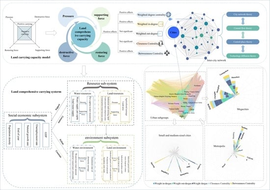
:
1. Introduction
2. Materials and Methods
2.1. Study Areas
2.2. Data Resources
2.3. Research Methods
2.3.1. Evaluation of Land Comprehensive Carrying Capacity
The Concept of Land Comprehensive Carrying Capacity
Evaluation Index System of Land Comprehensive Carrying Capacity
Land Comprehensive Carrying Capacity Contribution Value
2.3.2. Intercity Flow Network Construction
2.3.3. Spatial Econometric Model
3. Results
3.1. Spatial Characteristics of Land Comprehensive Carrying Capacity
3.2. Intercity Population Flow Network Characteristics
3.3. Influence of Intercity Network on Land Comprehensive Carrying Capacity
3.3.1. Model Construction and Selection
3.3.2. Regression Results
3.3.3. Further Examination Results
4. Discussion
4.1. Regional Differentiation Law of Land Comprehensive Carrying Capacity: Economic Relevance
4.2. External Effects on the Comprehensive Carrying Capacity of Land: Intercity Network Effect
4.3. Population Factor of Land Comprehensive Carrying Capacity: Dynamic Mobility
4.4. Policy Implications
5. Conclusions
Author Contributions
Funding
Data Availability Statement
Conflicts of Interest
References
- Shi, Y.; Wang, H.; Yin, C. Evaluation method of urban land population carrying capacity based on GIS–A case of Shanghai, China. Comput. Environ. Urban Syst. 2013, 39, 27–38. [Google Scholar] [CrossRef]
- Chen, H.; Jia, B.; Lau, S.S.Y. Sustainable urban form for Chinese compact cities: Challenges of a rapid urbanized economy. Habitat Int. 2007, 32, 28–40. [Google Scholar] [CrossRef]
- Song, X.; Kong, F.; Zhan, C. Assessment of water resources carrying capacity in Tianjin City of China. Water Resour. Manag. 2011, 25, 857–873. [Google Scholar] [CrossRef]
- Zhu, Y.; Drake, S.; Lu, H.; Xia, J. Analysis of temporal and spatial differences in eco-environmental carrying capacity related to water in the Haihe River Basins, China. Water Resour. Manag. 2010, 24, 1089–1105. [Google Scholar] [CrossRef]
- Lu, S.; Guan, X.; He, C.; Zhang, J. Spatio-temporal patterns and policy implications of urban land expansion in metropolitan areas: A case study of Wuhan Urban Agglomeration, Central China. Sustainability 2014, 6, 4723–4748. [Google Scholar] [CrossRef] [Green Version]
- Seto, K.C.; Reenberg, A.; Boone, C.G.; Fragkias, M.; Haase, D.; Langanke, T.; Marcotullio, P.; Munroe, D.K.; Olah, B.; Simon, D. Urban land teleconnections and sustainability. Proc. Natl. Acad. Sci. USA 2012, 109, 7687–7692. [Google Scholar] [CrossRef]
- He, F.; Yang, J.; Zhang, Y.; Sun, D.; Wang, L.; Xiao, X.; Xia, J. Offshore Island Connection Line: A new perspective of coastal urban development boundary simulation and multi-scenario prediction. Giscience Remote Sens. 2022, 59, 801–821. [Google Scholar] [CrossRef]
- Au, C.C.; Henderson, J.V. Are Chinese cities too small? Rev. Econ. Stud. 2006, 73, 549–576. [Google Scholar] [CrossRef] [Green Version]
- Glaeser, E.; Ponzetto, G.A.M.; Zou, Y. Urban Networks: Connecting Markets, People, and Ideas. Pap. Reg. Sci. 2016, 95, 17–59. [Google Scholar] [CrossRef] [Green Version]
- Fang, C. The basic law of the formation and expansion in urban agglomerations. J. Geogr. Sci. 2019, 29, 1699–1712. [Google Scholar] [CrossRef] [Green Version]
- McPhearson, T.; Haase, D.; Kabisch, N.; Gren, Å. Advancing understanding of the complex nature of urban systems. Ecol. Indic. 2016, 70, 566–573. [Google Scholar] [CrossRef]
- Su, S.; Liu, Z.; Xu, Y.; Li, J.; Pi, J.; Weng, M. China’s megaregion policy: Performance evaluation framework, empirical findings and implications for spatial polycentric governance. Land Use Policy 2017, 63, 1–19. [Google Scholar] [CrossRef]
- Tao, M.; Huang, Y.; Tao, H. Urban network externalities, agglomeration economies and urban economic growth. Cities 2020, 107, 102882. [Google Scholar] [CrossRef]
- Wang, Y.; Sun, B.; Zhang, T. Do polycentric urban regions promote functional spillovers and economic performance? Evidence from China. Reg. Stud. 2022, 56, 63–74. [Google Scholar] [CrossRef]
- Sheng, K.; Wang, L.; Sun, W. Patterns and determinants of functional division of cities across product value chain in China. Geogr. Res. 2020, 39, 2763–2778. [Google Scholar] [CrossRef]
- Camagni, R.P.; Salone, C. Network urban structures in northern Italy: Elements for a theoretical framework. Urban Stud. 1993, 30, 1053–1064. [Google Scholar] [CrossRef]
- Burger, M.J.; Meijers, E.J.; Hoogerbrugge, M.M.; Tresserra, J.M. Borrowed size, agglomeration shadows and cultural amenities in North-West Europe. Eur. Plan. Stud. 2015, 23, 1090–1109. [Google Scholar] [CrossRef]
- Meijers, E. Polycentric urban regions and the quest for synergy: Is a network of cities more than the sum of the parts? Urban Stud. 2005, 42, 765–781. [Google Scholar] [CrossRef]
- Masahisa, F.; Paul, K.; Anthony, J. Venables. The Spatial Economy: Cities, Regions and International Trade; Translated by Liang Qi; China Renmin University Press: Beijing, China, 2005. [Google Scholar]
- Wang, Y.; Ruan, H.; Tian, C. Access to high-speed rail and land prices in China’s peripheral regions. Cities 2022, 130, 103877. [Google Scholar] [CrossRef]
- National Bureau of Statistics of the People’s Republic of China. Main Data of the Seventh Census; China Statistics Press: Beijing, China, 2021. [Google Scholar]
- Duan, C.; Lv, L.; Wang, H.; Xie, D. From Rural China to Migrating China: Rethinking Migration Transition in China. Popul. Res. 2020, 44, 19–25. [Google Scholar]
- Li, S. Population migration regional economic growth and income determination: A comparative study of Dongguan and Meizhou China. Urban Stud. 2014, 34, 999–1026. [Google Scholar] [CrossRef]
- Tan, M.; Li, X. Paradigm transformation in the study of man-land relations: From local thinking to global network thinking modes. Acta Geogr. Sin. 2021, 76, 2333–2342. [Google Scholar] [CrossRef]
- Xue, B.; Li, J.; Xiao, X.; Xie, X.; Lu, C.; Ren, W.; Jiang, L. Overview of Man-Land Relationship Research Based on POI Data: Theory, Method and Application. Geogr. Geo-Inf. Sci. 2019, 35, 51–60. [Google Scholar] [CrossRef]
- Li, X.; Yang, Y.; Liu, Y.; Lu, Y.; Xia, S. The Systematic Structure and Trend Simulation of China’s Man-land Relationship Until 2050. Sci. Geogr. Sin. 2021, 41, 187–197. [Google Scholar] [CrossRef]
- Yang, Y.; Li, X.; Dong, W.; Hong, H.; He, Z.; Jin, F.; Liu, Y. Comprehensive evaluation on China’s man-land relationship: Theoretical model and empirical study. J. Geogr. Sci. 2019, 29, 1261–1282. [Google Scholar] [CrossRef] [Green Version]
- Sevtsuk, A.; Ratti, C. Does Urban Mobility Have a Daily Routine? Learning from the Aggregate Data of Mobile Networks. J. Urban Technol. 2010, 17, 41–60. [Google Scholar] [CrossRef]
- Anto, A.; Pilleriine, K.; Erki, S.; Jan, Š.; Janika, R. Spatial interpolation of mobile positioning data for population statistics. J. Locat. Based Serv. 2021, 15, 239–260. [Google Scholar] [CrossRef]
- Loibl, W.; Toetzer, T. Modeling growth and densification processes in suburban regions—Simulation of landscape transition with spatial agents. Environ. Model. Softw. 2003, 18, 553–563. [Google Scholar] [CrossRef]
- Niu, F.; Feng, Z.; Liu, H. A review on evaluating methods of regional resources and environment carrying capacity. Resour. Sci. 2018, 40, 655–663. [Google Scholar] [CrossRef] [Green Version]
- Hu, H.; Han, L. Evaluation of Land Carrying Capacity of 31 Provinces in China Based on a Natural–Societal-Supply–Demand Framework. Sustainability 2023, 15, 1037. [Google Scholar] [CrossRef]
- Zhang, D.; Zhu, l.; Ma, X.; Liu, Z.; Cui, H. Uncoordinated Coupling Assessment of New Urbanization and Ecological Carrying Capacity in the Yellow River Basin. Int. J. Environ. Res. Public Health 2022, 19, 9016. [Google Scholar] [CrossRef]
- Wang, L.; Liu, H. The comprehensive evaluation of regional resources and environmental carrying capacity based on PS-DR-DP theoretical model. Acta Geogr. Sin. 2019, 74, 340–352. [Google Scholar] [CrossRef]
- Xu, X.; Liu, J.; Zhang, S.; Li, R.; Yan, C.; Wu, S. China Multi-Period Land Use and Land-Cover Change Remote Sensing Monitoring Data Set (CNLUCC); Data Registration and Publication System of the Data Centre for Resource and Environmental Sciences; Chinese Academy of Sciences: Beijing, China, 2018. [Google Scholar] [CrossRef]
- Robert, M.T. Essay on the Principle of Population: The 1803 Edition; Yale University Press: London, UK, 2019. [Google Scholar]
- Sayre, N.F. The genesis, history, and limits of carrying capacity. Ann. Assoc. Am. Geogr. 2008, 98, 120–134. [Google Scholar] [CrossRef]
- Wang, S.; Mao, H.; Zhao, M. Thinking on the index system design to the land comprehensive carrying capacity—A case study: Coastal region of China. Hum. Geogr. 2001, 16, 57–61. [Google Scholar] [CrossRef]
- Lu, Y. Study on Evaluation of Regional Land Comprehensive Carrying Capacity and Application Research; China University of Geosciences: Beijing, China, 2014. [Google Scholar]
- Zhang, S.; Ruan, D. Evaluation of resources and environment carrying capacity from the perspective of resource cross-regional mobility: A dynamic evaluation framework and practice. J. Nat. Resour. 2020, 35, 2358–2370. [Google Scholar] [CrossRef]
- Li, C.; Liu, B. Air pollution embodied in China’s trade with the BR countries: Transfer pattern and environmental implication. J. Clean. Prod. 2019, 247, 119126. [Google Scholar] [CrossRef]
- Luo, W.; Ren, Y.; Shen, L.; Zhu, M.; Jiang, Y.; Meng, C.; Zhang, P. An evolution perspective on the urban land carrying capacity in the urbanization era of China. Sci. Total Environ. 2020, 744, 140827. [Google Scholar] [CrossRef]
- He, Z.; Wang, H.; Wei, M.; Gui, Y.; Zhao, Z.; Zhang, B.; Liu, Z. Evolution trend and prediction of Keriya river oasis niche in recent 11 years. J. Arid. Land Resour. Environ. 2017, 31, 75–80. [Google Scholar] [CrossRef]
- Shi, X. The Coupling of Population Movement and Land Comprehensive Carrying Capacity in China; Jilin University: Changchun, China, 2021. [Google Scholar] [CrossRef]
- Nasirzadeh, F.; Ghayoumian, M.; Khanzadi, M.; Rostamnezhad, C.M. Modelling thesocial dimension of sustainable development using fuzzy cognitive maps. Int. J. Constr. Manag. 2020, 20, 223–236. [Google Scholar] [CrossRef]
- Tang, Y.; Yuan, Y.; Zhong, Q. Evaluation of Land Comprehensive Carrying Capacity and Spatio-Temporal Analysis of the Harbin-Changchun Urban Agglomeration. Int. J. Environ. Res. Public Health 2021, 18, 521. [Google Scholar] [CrossRef]
- Shen, L.; Shu, T.; Liao, X.; Yang, N.; Ren, Y.; Zhu, M.; Wang, J. A new method to evaluate urban resources environment carrying capacity from the load-and-carrier perspective. Resour. Conserv. Recycl. 2020, 154, 104616. [Google Scholar] [CrossRef]
- Liao, X.; Ren, Y.; Shen, L.; Shu, T.; He, H.; Wang, J. A “carrier-load” perspective method for investigating regional water resource carrying capacity. J. Clean. Prod. 2020, 269, 122043. [Google Scholar] [CrossRef]
- Zhang, H.; Wang, Z.; Liu, J.; Chai, J.; Wei, C. Selection of targeted poverty alleviation policies from the perspective of land resources-environmental carrying capacity. J. Rural. Stud. 2022, 93, 318–325. [Google Scholar] [CrossRef]
- Zhang, C.; Yang, Y.; Feng, Z.; Lang, T.; Liu, Y. Spatio-temporal patterns of the land carrying capacity in the Belt and Road region based on human-cereals relationship. J. Nat. Resour. 2022, 37, 616–626. [Google Scholar] [CrossRef]
- Liu, Z.; Ren, Y.; Shen, L.; Liao, X.; Wei, X.; Wang, J. Analysis on the effectiveness of indicators for evaluating urban carrying capacity: A popularity-suitability perspective. J. Clean. Prod. 2020, 246, 119019. [Google Scholar] [CrossRef]
- Yuan, Y.; Chuai, X.; Xiang, C.; Gao, R. Carbon emissions from land use in Jiangsu, China, and analysis of the regional interactions. Environ. Sci. Pollut. Res. 2022, 29, 44523–44539. [Google Scholar] [CrossRef]
- Wu, Q.; Cao, Y.; Fang, X.; Wang, J.; Li, G. A systematic coupling analysis framework and multi-stage interaction mechanism between urban land use efficiency and ecological carrying capacity. Sci. Total Environ. 2022, 853, 158444. [Google Scholar] [CrossRef] [PubMed]
- Liu, C.; Yan, S. Spatial evolution and determinants of transnational technology transfer network in China. Acta Geogr. Sin. 2022, 77, 331–352. [Google Scholar] [CrossRef]
- Jiang, L. The Choice of Spatial Econometric Models Reconsidered in Empirical Studies. J. Stat. Inf. 2016, 31, 10–16. [Google Scholar]
- Wei, L.; Chen, Y.; Liu, Q.; Lu, Y. Coupling Research on Re sources and Environment Carrying apacity and Population Mobility in Heilongjiang Province Based on the P-S Curve. Geogr. Geo-Inf. Sci. 2020, 36, 95–105. [Google Scholar] [CrossRef]
- Xiao, Z. Hypothesis on Potential Energy Conversion of Population Migration in Theory: Re-interpretion of the push-pull migration laws. Popul. Econ. 2010, 6, 77–83. [Google Scholar]
- Li, Y. Spatial-Temporal Coupling Relationship between Urban Land Use Efficiency and Carrying Capacity of Regional Resources and Environment in the Yangtze River Economic Zone; Wuhan University: Wuhan, China, 2019. [Google Scholar]
- Huang, A.; Tian, L.; Yu, J.; Gao, Y.; Li, Y.; Li, Q.; Xiong, B. Comprehensive assessment of resource and environmental carrying capacity of village and town from the perspective of governance. Trans. Chin. Soc. Agric. Eng. 2021, 37, 232–241. [Google Scholar] [CrossRef]
- An, P. Positive Research on Environmental Protection Investment and Regional Economic Growth Relationship: View from Environmental Capacity Carrying; Ocean University of China: Qingdao, China, 2010. [Google Scholar]
- Tan, C.; Peng, Q.; Ding, T.; Zhou, Z. Regional Assessment of Land and Water Carrying Capacity and Utilization Efficiency in China. Sustainability 2021, 13, 9183. [Google Scholar] [CrossRef]
- Shi, M.; Li, Y.; Zhang, X.; Xiang, N. Will the haze control target of Beijing—Tianjin-Hebei region be realized? an assessment based on environmental carrying capacity. China Popul. Resour. Environ. 2017, 7, 6675. [Google Scholar] [CrossRef]
- Mao, X.; Huang, X.; Song, Y.; Zhu, Y.; Tan, Q. Response to urban land scarcity in growing megacities: Urban containment or inter-city connection? Cities 2020, 96, 102399. [Google Scholar] [CrossRef]
- Zhang, K. The emission reduction effects of economic agglomeration: An explanation based on spatial economics. Ind. Econ. Res. 2018, 94, 64–76. [Google Scholar] [CrossRef]
- Zhou, H.; Gu, G. The evolution of China’s city network and its environmental effects from the perspective of externalities. Geogr. Res. 2022, 41, 268–285. [Google Scholar] [CrossRef]
- Wu, C.; Wei, Y.; Huang, X.; Chen, B. Economic transition, spatial development and urban land use efficiency in the Yangtze River Delta, China. Habitat Int. 2017, 63, 67–78. [Google Scholar] [CrossRef]
- Zhao, X.; Shang, Y.; Song, M. What kind of cities are more conducive to haze reduction: Agglomeration or expansion? Habitat Int. 2019, 91, 102027. [Google Scholar] [CrossRef]
- Han, F.; Xie, R.; Lu, Y.; Fang, J.; Liu, Y. The effects of urban agglomeration economies on carbon emissions: Evidence from Chinese cities. J. Clean. Prod. 2018, 172, 1096–1110. [Google Scholar] [CrossRef]
- Zhang, S.; Zhang, L.; Zhang, L.; Gao, S. Coupling relationship between polluting industrial agglomeration and water environment pollution in Southern Jiangsu of Taihu Lake Basin. Sci. Geogr. Sin. 2018, 38, 954–962. [Google Scholar] [CrossRef]
- Hu, Z.; Miao, C.; Yuan, F. Impact of industrial spatial and organizational agglomeration patterns on industrial SO2 emissions of prefecture-level cities in China. Acta Geogr. Sin. 2019, 74, 2045–2061. [Google Scholar] [CrossRef]
- Gong, P.; Zhang, S. Spatial-temporal effects of industrial agglomeration patterns on urban land use efficiency. Ind. Organ. Rev. 2022, 16, 54–75. [Google Scholar]
- Shen, L.; Cheng, G.; Du, X.; Meng, C.; Ren, Y.; Wang, J. Can urban agglomeration bring “1 + 1 > 2Effect”? A perspective of land resource carrying capacity. Land Use Policy 2022, 117, 106094. [Google Scholar] [CrossRef]
- Capello, R. The City Network Paradigm: Measuring Urban Network Externalities. Urban Stud. 2000, 37, 1925–1945. [Google Scholar] [CrossRef]
- Wei, Y.; Huang, C.; Li, J.; Xie, L. An evaluation model for urban carrying capacity: A case study of China’s mega-cities. Habitat Int. 2016, 53, 87–96. [Google Scholar] [CrossRef]
- Zhang, Z.; Jin, G.; Guo, B.; Dong, Y.; Chen, K. Research on the spatial vulnerability and resilience of land in the Yangtze River Economic Belt based on multi-criteria decision. J. Nat. Resour. 2020, 35, 95–105. [Google Scholar] [CrossRef]
- Zheng, S.; Kahn, M. China’s bullet trains facilitate market integration and mitigate the cost of megacity growth. Proc. Natl. Acad. Sci. USA 2013, 110, 1248–1253. [Google Scholar] [CrossRef]
- Yang, G.; Zhao, Y.; Xing, H.; Fu, Y.; Liu, G.; Kang, X.; Mai, X. Understanding the changes in spatial fairness of urban greenery using time-series remote sensing images: A case study of Guangdong-Hong Kong-Macao Greater Bay. Sci. Total Environ. 2020, 715, 136763. [Google Scholar] [CrossRef]
- Veneri, P.; Burgalassi, D. Questioning polycentric development and its effects. Issues of definition and measurement for the Italian NUTS-2 Regions. Eur. Plan. Stud. 2012, 20, 1017–1037. [Google Scholar] [CrossRef] [Green Version]
- Zhou, K.; Fan, J. Characteristics and influence factors of resources and environment carrying capacity in underdeveloped areas of China. Geogr. Res. 2015, 34, 39–52. [Google Scholar] [CrossRef]
- Xi, G.; Zhen, F.; Qian, Q. Territory spatial security and planning strategies from the perspective of mobility. J. Nat. Resour. 2022, 37, 1935–1945. [Google Scholar] [CrossRef]
- Liu, Y.; Fang, F.; Li, Y. Key issues of land use in China and implications for policy making. Land Use Policy 2014, 40, 6–12. [Google Scholar] [CrossRef]
- Yang, J.; Guo, A.; Li, Y.; Zhang, Y.; Li, X. Simulation of Landscape Spatial Layout Evolution in Rural-urban Fringe Areas: A Case Study of Ganjingzi District. GIScience Remote Sens. 2018, 56, 388–405. [Google Scholar] [CrossRef]
- Wei, Y.; Huang, C.; Lam, P.T.I.; Yuan, Z. Sustainable urban development: A review on urban carrying capacity assessment. Habitat Int. 2015, 46, 64–71. [Google Scholar] [CrossRef]
- Camagni, R.; Capello, R.; Caragliu, A. One or infinite optimal city sizes? In search of an equilibrium size for cities. Ann. Reg. Sci. 2013, 51, 309–341. [Google Scholar] [CrossRef]
- Qin, X.; Zhen, F. Discussion on urban construction land allocation based on element flow. J. Nat. Resour. 2022, 37, 2774–2788. [Google Scholar] [CrossRef]


| Goal Layer | Impact Factors | Indicators | Serial Number | The Nature of Indicators |
|---|---|---|---|---|
| Pressure | Water resources | Water consumption per capita | P11 | - |
| Total urban water supply | P12 | - | ||
| Land resources | Occupied land of industrial and mining | P13 | - | |
| Annual cultivated land reduction area | P14 | - | ||
| Population | Population density | P15 | - | |
| Permanent resident population | P16 | - | ||
| Natural population growth rate | P17 | - | ||
| Urban unemployment rate | P18 | - | ||
| Supporting force | Resource support | Per capita water resources | S21 | + |
| Land area | S22 | + | ||
| Cultivated land area | S23 | + | ||
| Per capita grain output | S24 | + | ||
| Economic and social support | Whole-society productivity | S25 | + | |
| Investment intensity of fixed assets | S26 | + | ||
| Per capita disposable income of urban residents | S27 | + | ||
| Per capita disposable income of rural residents | S28 | + | ||
| Destructive force | Water environment | Discharge amount of industrial wastewater | D31 | - |
| Total wastewater discharge | D32 | - | ||
| Edatope | Output of industrial hazardous solid waste | D33 | - | |
| Output of general industrial solid waste | D34 | - | ||
| Restoring force | Pollution treatment capacity | Treatment rate of domestic sewage | R41 | + |
| Industrial hazardous solid waste disposal volume | R42 | + | ||
| Industrial general solid waste disposal volume | R43 | + |
| Land Comprehensive Carrying Capacity | Coeff. | Std. Err. | t-Statistic | P > z |
|---|---|---|---|---|
| 0.331944 | 0.150606 | 2.20405 | 0.02815 | |
| 1.43435 | 0.294987 | 4.86241 | 0.00000 | |
| −0.0130182 | 0.0293354 | −0.443772 | 0.65747 | |
| 0.0593548 | 0.0885587 | 0.670231 | 0.00314 | |
| −0.0778451 | 0.0916931 | −0.848974 | 0.39645 | |
| _cons | −0.000051978 | 0.024079 | 0.00215864 | 0.005 |
| R2 | 0.725452 | |||
| Log likelihood | −236.824 | |||
| AIC | 491.648 | |||
| SC | 526.894 | |||
| LM-lag | 64.2471 | 0.00000 | ||
| Robust LM-lag | 6.8005 | 0.05911 | ||
| LM-error | 94.1731 | 0.00000 | ||
| Robust LM-error | 36.7266 | 0.00000 |
| Land Comprehensive Carrying Capacity | Spatial Lag Model | SEM | ||||
|---|---|---|---|---|---|---|
| Coef. | Std. Err. | P > z | Coef. | Std. Err. | P > z | |
| 0.25109 | 0.135898 | 0.00000 *** | 0.718362 | 0.1386 | 0.00000 *** | |
| 0.0925256 | 0.030035 | 0.00207 *** | 1.61875 | 0.259608 | 0.00000 *** | |
| −0.00535188 | 0.0264466 | 0.83963 | −0.0098843 | 0.0239549 | 0.67988 | |
| 0.0385628 | 0.079804 | 0.01275 ** | 0.0147454 | 0.0776941 | 0.046 * | |
| −0.0993748 | 0.0827668 | 0.22988 | −0.046713 | 0.0767127 | 0.54257 | |
| R2 | 0.771509 | 0.794416 | ||||
| Log likelihood | −207.089 | −196.953756 | ||||
| AIC | 434.177 | 411.908 | ||||
| SC | 473.339 | 447.153 | ||||
| Variable Name | Model I | Model II | Model III | |||
|---|---|---|---|---|---|---|
| Land Comprehensive Carrying Capacity | Land Use Efficiency | Land Comprehensive Carrying Capacity | ||||
| β | t | β | t | β | t | |
| Weighted degree centrality | 0.800 | 22.629 *** | 0.657 | 14.797 *** | 0.673 | 14.770 *** |
| Weighted indegree | 0.800 | 22.611 *** | 0.658 | 14.825 *** | 0.673 | 14.746 *** |
| Betweenness centrality | 0.481 | 9.303 *** | 0.331 | 5.955 *** | 0.304 | 6.768 *** |
| Land use efficiency | 0.193 | 4.228 *** | ||||
| Sample size | 287 | 287 | 287 | |||
| R2 | 0.64 | 0.432 | 0.661 | |||
| Adjusted R2 | 0.639 | 0.43 | 0.659 | |||
| F value | F (1,288) = 512.069, p = 0.000 | F (1,288) = 218.965, p = 0.000 | F (2,287) = 279.972, p = 0.000 | |||
| Variable Name | Model IV | Model V | Model VI | |||
|---|---|---|---|---|---|---|
| Land Comprehensive Carrying Capacity | Environmental Governance Level | Land Comprehensive Carrying Capacity | ||||
| β | t | β | t | β | t | |
| Weighted degree centrality | 0.800 | 22.629 *** | 0.013 | 0.229 | 0.800 | 22.586 *** |
| Weighted in-degree | 0.800 | 22.611 *** | 0.012 | 0.198 | 0.800 | 22.570 *** |
| Betweenness centrality | 0.481 | 9.303 *** | −0.120 | −2.044 * | 0.490 | 9.426 *** |
| Environmental governance level | 0.075 | 1.444 | ||||
| Sample size | 287 | 287 | 287 | |||
| R2 | 0.231 | 0.014 | 0.237 | |||
| Adjusted R2 | 0.228 | 0.011 | 0.231 | |||
| F value | F (1,288) = 86.545, p = 0.000 | F (1,288) = 4.180, p = 0.042 | F (2,287) = 44.478, p = 0.000 | |||
Disclaimer/Publisher’s Note: The statements, opinions and data contained in all publications are solely those of the individual author(s) and contributor(s) and not of MDPI and/or the editor(s). MDPI and/or the editor(s) disclaim responsibility for any injury to people or property resulting from any ideas, methods, instructions or products referred to in the content. |
© 2023 by the authors. Licensee MDPI, Basel, Switzerland. This article is an open access article distributed under the terms and conditions of the Creative Commons Attribution (CC BY) license (https://creativecommons.org/licenses/by/4.0/).
Share and Cite
Shi, X.; Yu, X.; Wang, S.; Hao, F. Influence of Intercity Network on Land Comprehensive Carrying Capacity: A Perspective of Population Flow. Land 2023, 12, 1515. https://doi.org/10.3390/land12081515
Shi X, Yu X, Wang S, Hao F. Influence of Intercity Network on Land Comprehensive Carrying Capacity: A Perspective of Population Flow. Land. 2023; 12(8):1515. https://doi.org/10.3390/land12081515
Chicago/Turabian StyleShi, Xiang, Xiao Yu, Shijun Wang, and Feilong Hao. 2023. "Influence of Intercity Network on Land Comprehensive Carrying Capacity: A Perspective of Population Flow" Land 12, no. 8: 1515. https://doi.org/10.3390/land12081515