Article

Forest Transition and Fuzzy Environments in Neoliberal Mexico

1
Department of Geography, University of Florida, Gainesville, FL 32611, USA
2
Centro de Investigaciones en Geografía Ambiental, Universidad Nacional Autónoma de México, Antigua Carretera a Pátzcuaro 8701, Col. San José de la Huerta, Morelia 58190, Michoacán, Mexico
3
Center for Latin American Studies, University of Florida, Gainesville, FL 32611, USA
4
Grupo Interdisciplinario de Tecnología Rural Apropiuada (GIRA A.C.), Carretera Pátzcuaro a Erongarícuaro 28, Tzentzenguaro, Pátzcuaro 61613, Michoacán, Mexico
5
ECOTRUST, 6721 NW 9th Ave. Suite 200, Portland, OR 97209, USA
6
Latin American Studies College of Arts & Sciences, University of Redlands, 1200 E. Colton Ave, Redlands, CA 9237, USA
*
Authors to whom correspondence should be addressed.
Land 2023, 12(4), 840; https://doi.org/10.3390/land12040840
Submission received: 20 February 2023 / Revised: 25 March 2023 / Accepted: 28 March 2023 / Published: 6 April 2023
(This article belongs to the Special Issue Feature Papers for Land Systems and Global Change Section)

Abstract

:
Although deforestation remains a continuing threat to both the natural world and its resident human populations, a countervailing land cover dynamic has been observed in many nations. This process of landscape turnaround, the so-called forest transition, holds the potential of regenerating ecosystem services by sparing land from agricultural activities and abandoning it to forest succession. Here, we present a case study of a long-term process of forest transition that is ongoing in the Patzcuaro watershed of the state of Michoacán, Mexico. The research to be discussed comprises a remote sensing analysis designed to (1) capture the land cover impacts of a multidecadal process of trade liberalization (1996–2018); (2) ascertain the role that land tenure plays in land use dynamics affecting forest cover, and (3) resolve forest cover types into native forest, secondary vegetation, and “commodity” covers of fruit trees, in this case, avocado. Mexico presents a useful case for addressing these three design elements. Our analysis, undertaken for both private property and collective modes of resource management in five communities, reveals a forest transition annualized at 20 ha-yr−1, or a gain of eight percent for the period. This translates into a relative rate of forest transition of 0.39%-yr−1 which is three times faster than what is occurring in the temperate biome on a national scale (0.07%-yr−1). Most of the forest transition is occurring on private holdings and stems from field abandonment as farming systems intensify production with avocado plantations and cow–calf operations. As this study demonstrates, forest transitions are not occurring ubiquitously across nations but instead are highly localized occurrences driven by a myriad of distal and proximate factors involving disparate sets of stakeholders. Consequently, policy makers who are keen to expand forest transitions to fulfill their national climate action commitments under the Paris Agreement must first promote research into the complexity of landscapes and drivers of land change at regional and local scales.

1. Introduction

The conversion of native forests is one of the most important processes contributing to the current global environmental crisis. It accounts for 38% of the carbon emissions from agriculture, which contributes ~25% of greenhouse gas (GHG) emissions to the atmosphere [1]. In addition, deforestation and forest degradation are the primary drivers of species extinctions on land and the loss of livelihood for the millions of people who rely on the ecosystem services provided by forests [2,3]. It should come as no surprise that measuring this environmental transformation and understanding its proximate and underlying causes now comprise a major interdisciplinary research area. Although deforestation remains a continuing threat to both the natural world and its resident human populations, a countervailing land cover dynamic has been observed in many nations. This process of landscape turnaround, the so-called forest transition (FT), holds the potential of regenerating ecosystem services by sparing land from agricultural activities and abandoning it to forest succession.
Specifically, FT provides a critical empirical foundation for greenhouse gas (GHG) emissions policy based on carbon sequestration and is therefore highly consistent with the goals of the United Nations Program on Reducing Emissions from Deforestation and Forest Degradation, or UN-REDD [4,5]. Recently, controlling anthropogenic greenhouse gas (GHG) release to the atmosphere with forest-based policy has been widely adopted by signatories to the Paris Climate Treaty, particularly by nations with large forests and dynamic agricultural economies, such as those found throughout the global south. FT, although first observed in the global north, is increasingly affecting forests wherever they are found. This article takes up the case of Mexico, which has set a goal of 0% deforestation by 2030 as part of its commitment to the Paris Climate Treaty. In particular, we present the results of a study addressing land cover change dynamics in an old agricultural frontier where FT was observed over twenty years ago. Our objective was to assess the continuity of this process given the significant changes in the institutional and economic environments affecting Mexico and the global economy more generally.
We pursue our objective as follows: First, we provide an overview of the manner in which FT has been conceptualized and touch on the literature that has extended its range of applications, both spatially and temporally. After this, we focus on Latin America and consider cases of FT occurring across the region at the present time. This sets the stage for the presentation of research on Mexico. For this, we present results from a remote sensing analysis combined with data collected from a survey of smallholders. Finally, we discuss our findings and draw a brief conclusion that questions to what degree FT can be regarded as an ecologically restorative process.
Before proceeding, we wish to address two terminological issues. The first concerns our use of the term “forest transition” as opposed to “land sparing.” Although both reflect processes that for all intents and purposes are identical, we elected to use “forest transition” as our operative phrasing given its early usage as a term reflecting long-term patterns of land cover change tied to broad-scale global dynamics. This is appropriate given that the analysis we present covers a multidecadal period of nearly fifty years, during which time neoliberal reforms profoundly affected many national economies. The second issue involves FT’s descriptive categories, a binary of highly aggregated land covers, one that exhibits exclusively positive environmental qualities (forest) and one that does not (non-forest). Such a sharp distinction is often absent from densely settled parts of the world such as Mexico, where human populations have long derived subsistence from agroecological matrices that include trees from the original biome as well as agricultural land uses. In these situations, land covers are environmentally “fuzzy” because they manifest varying intensities of ecosystem service provision. Our usage of the term “fuzzy” derives from the concept of the fuzzy set, whose members elicit variable degrees of membership. They cannot be construed as belonging to a binary scheme of categorization comprising covers that conserve the environment and its ecosystem services and covers that do not.
Mather [6] and Walker [7] use the terms forest areal transition and landscape turnaround, respectively, in referring to shifting trends in the national land covers of Europe, North America, and the Pacific Rim, from a period of forest decline to one of net expansion. Their original formulations rested on a hypothesized relationship between land cover dynamics and long-run structural changes in a national economy, with agricultural development driving deforestation, after which industrialization sparks rural-to-urban migration as farmers abandon their fields to take manufacturing jobs in cities. Intensifying this process of abandonment are technological changes that reduce the demand for farmland by raising agricultural productivity, which is further enhanced as communication networks reveal regional comparative advantages and production shifts from marginal to fertile areas. Technological changes also attenuate forest exploitation by providing new energy sources and building materials as substitutes for fuelwood and timber. Finally, as consumer preferences for natural amenities develop with rising incomes, state environmental policies reinforce the recovery of natural areas in the interest of conservation. The sum total of all these effects is that the pressure on forests is reduced and that formerly exploited lands are abandoned to forest succession, the foundational FT process [6,7].
Critics of the early formulation, which draws a correspondence between dynamics in a national economy and regional landscapes, point to its congruence with developmentalist thinking and the apparent restriction to an isomorphic pattern with necessary “stages”, also known as the Rostow paradigm of growth [8]. This critique questions the alleged spontaneity of forest recovery in the face of industrial capitalism, arguing that FT necessarily requires state intervention in resource exploitation by the private sector and does not proceed by a natural succession of preordained stages [9]. It also points to the impact of institutions, trade, and historical contingency on FT, given that alleged necessary conditions do not always lead to the expected outcome [8,10,11,12]. Behavioral contingency plays a role as well, given the wide variety of skills individuals possess and the great diversity in their preferences for production and consumption.
More recent critiques call attention to scale and foundational issues of measurement and definition [13]. As for scale, there is no a priori reason to restrict FT to the nation-state given that processes of forest recovery occur not just at the macro-scale but also in highly localized settings [14,15,16]. In fact, aggregate deforestation might conceal regional FT as a function of the biome [15,17,18]. As for the issue of measurement, ecologists have pointed to the false dichotomy between conservation and agriculture inherent in FT theory, which is based on an agriculture–forest binary equating forests with conservation and agriculture with degradation [19,20]. Many landscapes are highly fragmented, with matrices combining agriculture and forest as opposed to distinct partitions into two categories, as noted at the outset. Further, the forest itself may provide agricultural values either by grazing or by the substitution of trees producing commodities for those of the original biome. In such landscapes, ecosystem services are more likely to be provided by a matrix of agroecological land use than by native forests. This framing, compatible with the whole landscape approach [21], recognizes a persistent rurality in which indigenous and other rural people do not abandon marginal lands but instead adapt their practices to the agroecological environment [22,23,24]. In these cases, small-scale sustainable agriculture can contribute effectively to an ecosystem services conservation strategy in the absence of a stylized FT.
This study presents research attentive to scale, both spatially and temporally, which accounts for the definitional issues raised by ecologists. With respect to spatial scale, we address complex, countervailing processes whereby aggregate deforestation conceals a disaggregate FT as a function of biome type [17]. In addition, the detail of our remote sensing analysis enables us to decompose the “forest” category into native forest and fruit tree plantations, which in our case possess contradictory implications for conservation. We are therefore able to address the binary framing of conventional FT theory with a “fuzzy” approach that translates forested and non-forested land covers into an agroecological matrix. In undertaking our analysis with a representative case study, we implement a multidecadal time span consistent with early FT conceptualization. Thus, the analysis period brackets long-run changes in Mexico’s macro-economy driven by neoliberal reforms. Finally, the temporal scale implemented provides an opportunity to examine the impact of land tenure and property rights on localized FT, given that it covers changes in the institutional environment that have generated a complex pattern of private and communal holdings in the study area. Many have called attention to the role of property institutions in explaining dynamic land cover processes such as deforestation. Consequently, since land tenure affects land use decisions, FT, as an outcome of agricultural decision-making, must necessarily reflect the institutional context in which it occurs [10,25]. To date, little empirical work has documented how land rights impact restorative ecological processes such as FT.

1.1. Forest Dynamics in Latin America

Mather [6] and Walker [7] documented FT in much of the global north and argued there was no guarantee it would occur where nations were still experiencing high rates of deforestation, such as in the global south. Nevertheless, research has now documented FT in a wide variety of settings [25,26,27,28]. For example, Grau and Aide [27] point to 18 Latin American cases occurring between 1996 and 2008. Most of them—incipient and highly localized—involve relatively small areas, with half covering less than 5000 km2 and only three exceeding 100,000 km2. In addition to the reduced extent, the identified FTs are recorded for periods of short duration and do not necessarily reflect long-term dynamics associated with structural changes in an economy. Only two FTs appear to be occurring at a national scale, one in Puerto Rico and the other in El Salvador.
Puerto Rico is a commonwealth of the US, where manufacturing is heavily subsidized and emigration to the United States is unrestricted [7]. Here, annual rates of forest recovery from 1940 to 1990 have been estimated at between 9% [7] and 0.63% [29]. The other macro-scale FT is occurring in El Salvador, where civil war displaced a large part of the rural population in the 1980s [30]. Since 1990, forest covers have expanded by 7% in El Salvador’s closed forests and 30% in its open forests [30]. The Brazilian Legal Amazon provides another relevant example given the area covered, ~5 million km2. Here, Perz and Skole [31] reported declining rates of deforestation, with an increasing expansion of secondary forests for the period 1986–1992. Net secondary forest gain represents only 1% in the aggregate, but in old settlement areas of the lower basin, it reaches 25%. Finally, regional FT over a large area is occurring in the Atlantic Rainforest biome of Brazil, as documented by [17].
FTs in Puerto Rico, El Salvador, and Brazil reflect histories of agricultural land abandonment, where country-specific contingencies have managed to push and pull people from rural areas, with significant depopulation in the countryside [30,32]. Studies of Latin American FTs at more localized scales have emphasized the impact of changing livelihood strategies on household mobility [16,33,34]. For example, Rudel et al. [35] used remotely sensed and household data to investigate FT in the Peruvian Amazon. Schmook and Radel [36] took a similar approach to the southern Yucatan in Mexico. Results from both studies confirm an incipient FT in each case but diverge in their explanations. In Yucatán, out-migration and non-farm job opportunities appear to be driving a decline in deforestation. By contrast, out-migration does not appear to promote FT in the Peruvian Amazon, where household decisions about land use and livelihood diversification play key roles.
These Latin American examples suggest that landcover change dynamics sometimes, but not always, follow an FT narrative in which rural out-migration and forest recovery are linked to changes in national and global economies [15,37]. Our work provides an additional case study for Mexico, specifically in the highlands of Michoacán, where previous research has explored how landscape processes are linked to economic dynamics occurring at various scales, from global to local. Much of this work suggests an FT may be underway as agricultural abandonment leads to spontaneous forest regeneration [25,38], while other observations suggest drastic forest loss due to illegal logging and conversion to export-oriented avocado orchards [39].

1.2. Forest Transition: The Mexican Case

Mexico presents a useful case for addressing forest transition. Of particular note is the process of neoliberal reform that it has experienced since the 1980s with the General Agreement on Trade and Tariffs (GATT, 1985), which was followed by the North American Free Trade Agreement (NAFTA) in 1994 and, most recently, the United States–Mexico–Canada Agreement (USMCA) in 2020. These reforms affected land tenure and market access for smallholder farmers throughout Mexico. Land tenure was impacted by the ejidos, the publicly held properties created during the land reforms of the Mexican Revolution. Although private farm properties have long existed in Mexico, they expanded significantly following Amendment 27 to the Mexican Constitution in 1992, which allowed for the privatization of ejidal farm parcels under strict guidelines [40]. In addition to this, trade liberalization essentially thrust Mexico into the global economy by reducing tariffs on imports and eliminating subsidies to production from the parastatal sector [41,42].
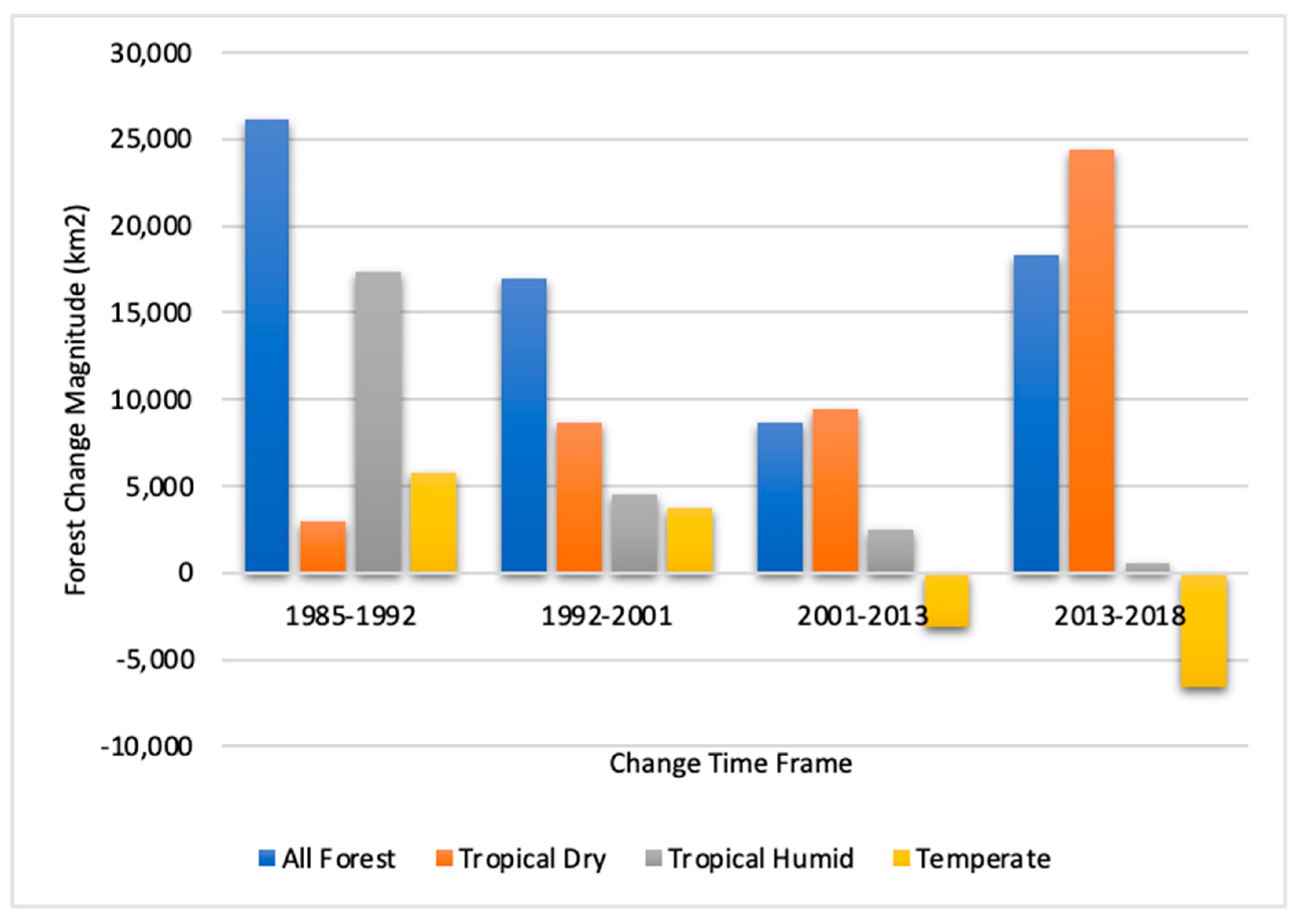
Trade liberalization in Mexico and neoliberal reforms more generally have tracked an autonomous process of agricultural intensification, which began with the green revolution in the 1960s with new varieties of wheat and maize. Also in evidence is a multidecadal process of land cover dynamics. An examination of total forest change magnitudes at a national scale reveals overall declines in deforestation rates through much of the time period until 2013, when rates began to rise once again (see Figure 1). The rate of deforestation between 1985 and 1992, 0.53% yr−1, declined to 0.11% yr−1 for the period 2002–2014. Of particular interest for this study are the forest cover dynamics revealed when the data are disaggregated by forest biomes. As the figure shows, deforestation rates in tropical humid biomes have steadily declined throughout the time period, and an apparent FT is underway in Mexico’s temperate forests, which increased their extent from 341,805 km2 in 2002 to 351,562 km2 in 2018, for an annual rate of transition of 610 km2 yr−1. Unfortunately, deforestation rates in tropical dry biomes show a pronounced rise across the time period, a trend that parallels deforestation patterns across the global south [18,43,44]. The dramatic and continually high deforestation rates in tropical dry biomes clearly explain the total deforestation rate trends on a national scale.

2. Methodology

2.1. Study Region: Physical and Social Characteristics

The present study addresses a specific case of a temperate FT, one occurring in the Patzcuaro Lake watershed (PLW) in the state of Michoacán, Mexico (see Figure 2). The PLW is part of the Purhépecha Indigenous Region, and, like many other parts of rural México, human settlement at this site is ancient, dating back more than 5000 years [46]. The watershed, covering ~1000 km2 [47], drains into Pátzcuaro Lake, with a surface area of 130 km2 and a 4.9 m mean depth [48]. The regional geomorphology is dominated by volcanic mountains, inter-mountainous valleys, piedmonts, and hills, with elevations ranging from 2035 m.a.s.l. at lake level to 3400 m.a.s.l., the altitude of the highest mountain [47]. The PLW possesses a mild, temperate climate, with an average annual temperature of 14.5 °C and an average rainfall of 1000 mm-yr−1 distributed mostly from June to October. Soils are of volcanic origin and are mostly fertile. Ecology is dominated by the temperate forest biome, consisting primarily of a mixed pine–oak forest. Fir trees (Abies religiosa) are found in the high elevations, while pine (Pinus pseudos-trobus, P. michoacana, and P. montezumae) and oak (Quercus rugosa, Q. castanea, and Q. laurina) grow on the wide slopes of the mountains. Lower elevations are covered by grasses and secondary herbaceous vegetation, presumably of anthropogenic origin [48].
Agriculture occurs on small holdings (<5 ha) in the flat areas around the lake and in the valleys [47]. The main seasonal crops are maize, oats, wheat, legumes, and vegetables. Tree crops are also grown, avocado in particular, but maize is the most important crop, representing 71% of the planted area (8115 ha total in 2014), followed by oats, which are used to feed cattle [46]. PLW agriculture takes place within a complex spectrum of land tenure institutions, ranging from private property to those reflecting a more communal approach. These include Comunidades Agrarias (agrarian communities), which recognize long-standing collective tenure rights, and ejidos, which are collective land reform grants. Under both collective arrangements, individual land managers generally have strong usufruct rights to planted fields and orchards, while lands with native tree cover are shared by the community as a whole. The private properties, agrarian communities, and ejidos in our study area are mostly inhabited by Purépecha Indigenous peoples. The agrarian community (AC), also referred to as the Indigenous community in this part of Mexico, includes a higher density of collective social institutions for self-governance and ritual celebrations.

2.2. Prior Research

A substantial amount of research has addressed resource use and agriculture in the PLW. Klooster [25] used aerial photographs (from the years 1942, 1960, 1974, and 1990) and satellite imagery (2000) together with key informant interviews to investigate long-run landscape dynamics in the PLW, including one of the communities in the present study. This work suggested an overall expansion of forest cover, primarily on agricultural fields that were far from towns or on poor soils [25,49]. In a similar study on the neighboring Lake Cuitzeo Basin, Lopez et al. [38] used aerial photographs from 1975 and 2000 to show, for the entire 4000 km2 watershed, a substantial expansion of scrubland areas following the abandonment of rainfed agriculture and a slight increase in the forest. Evidently, land abandonment occurred in ‘relatively unproductive’ areas, especially stony fields and hillsides with low yields. In several municipalities, however, avocado orchards replaced rain-fed agriculture.
These findings are generally consistent with the FT narrative stemming from agricultural abandonment [25,50]. Other land cover dynamics have been observed in the region. Although FT appears to be long-term and ongoing, deforestation to make way for avocado plantations is occurring in addition to logging, which is shifting species composition away from commercially valuable pine to less valuable oak by selective harvest [49]. Aside from outright resource exploitation, the PLW also provides examples of community forestry [39]. In an area approximately 50 km to the south of the PLW, Barsimantov and Navia Antezana [40] used Landsat TM and ETM images from 1990, 1996, 2002, and 2006 to conduct comparative landcover change analyses in four indigenous communities. Two of the four communities maintained effective communal organization, established legal community logging operations, and manifested drastically lower deforestation rates than the two others, which lacked effective communal organization. Here, communal forests were illegally logged, then extra-legally privatized by a transfer to non-community members who planted avocado. Most of the deforestation occurred during the early and mid-1990s, amid changes in communal tenure policy and a relaxation in log transportation rules.

2.3. Current Study

Our research comprises a remote sensing analysis designed to (1) capture the land cover impacts of a multidecadal process of trade liberalization; (2) ascertain the role that land tenure plays in land use dynamics affecting forest cover; and (3) resolve forest cover types into native and “commodity” covers of fruit trees, in this case, avocado. Our research complements earlier work by providing a quantitative assessment that disaggregates land change processes in the PLW into source land covers and by extending the analysis to the post-NAFTA period. The specific coverage area for the remote sensing analysis comprises five localities in the PLW, selected to ensure variation in land tenure regimes. These include communal lands in indigenous communities (San Andrés Tziróndaro, San Jerónimo Purenchécuaro) and ejidos (Erongarícuaro and La Zarzamora), in addition to private properties (also in Erongarícuaro) (see Figure 3). Ejido Zarzamora, Ejido Erongarícuaro, and the private properties under analysis are found in Municipio Erongarícuaro, while the two indigenous communities are located in Quiroga Municipio. We used remotely sensed data to produce land cover change matrices for each locality.
The remote sensing and GIS analysis involved change detection based on data from 1996 and 2018. For 1996, we created a land-use map by visual interpretation of black and white aerial photographs taken in 1996 at 2m spatial resolution. The aerial photographs were interpreted by an expert familiar with the study area and who had deep knowledge about the distribution of its land cover. In addition, information such as the form, shape, texture, and tone of the land cover classes was employed during the visual interpretation process. For 2018, we used very high spatial resolution images available in Google Earth, downloaded as an RGB photo and geometrically rectified, then projected to a common Universal Transverse Mercator projection (WGS 84, UTM 14N). The change analysis was carried out following an interdependent interpretation procedure developed by FAO [51], by which the first image is interpreted visually and then the second image is modified based on the interpretation. Accuracy assessment was not performed for the 1996 land-use map since there were no available high-resolution images in Google Earth to obtain ground truth data. The visual interpretation of aerial photographs by an expert was capable of producing land-use maps with high accuracy. By following this procedure, it was expected to be able to produce consistent change data. We superimposed the GE photo on the 1996 land cover map and visually identified the land cover areas that showed changes over the period; not all land use changed. The land cover categories implemented were forest (e.g., pine and oak), secondary vegetation (e.g., herbaceous vegetation, potential fallow, and dirty grazing pasture), annual crops (e.g., maize, legumes, vegetables), tree crops (e.g., avocado), and urban areas (built-up areas). Our change detection analysis produced transition matrices for the aggregate across all five localities as well as for each one. Net changes for each category of land use are given, as is the transition matrix for each pairwise permutation of the land use categories.

3. Results

Before presenting the results of the land cover change analysis, we provide background context by considering the socio-demographic conditions of the five localities (see Table 1). As is evident, the population of the agrarian communities (ACs) numbers in the thousands, considerably more than the relatively few people who live in the ejidos. A similar pattern emerges for the land area. In this case, both the land area for the ACs and the private holdings are larger than the ejidos. In general, the five localities have remained stable over time, even though the ejidos and AC of San Jerónimo are quite old. Although the ACs and ejidos have both benefited from government subsidies under PROCEDE, poverty remains entrenched.

3.1. Changes in Land Use

Aggregate changes in land use across the five localities for the period reflect three processes, namely: (1) the reduction in the area dedicated to annual crop production, (2) the emergence of tree crops, specifically avocado, and (3) the abandonment of secondary vegetation to ecological succession (see Table 2a). The aggregate reduction in the area under annual crop production in the study region, in particular maize, is the dominant agricultural dynamic, with a decline of ~550 ha from ~3872 ha in 1996, or about 14 percent. For its part, avocado production expanded dramatically from a limited 5 ha dedicated to the crop in 1996 to more than 230 ha by 2018. During this same time period, private properties decreased the area under annual crops by 547 ha. The two indigenous communities manifest rather static dynamics, with farming based solidly on annual crops in both periods; neither has planted tree crops and only San Jerónimo shows any change in secondary vegetation, with a reduction of ~90 ha from ~350 ha in 1996. The annual crop area has remained stable in Ejido Erongarícuaro, where 8 ha of avocado were planted sometime after 1996. Tree crops were not planted in Ejido Zarzamora, which shows the abandonment of land under annual crops. The areas here are small relative to the other localities and therefore do not affect the aggregate dynamics.

3.2. Forest Transition

In 1996, forest covered ~5448 ha of the five localities in the sample, and by 2018, 435 ha had been added, yielding an annualized transition of 20 ha-yr−1, or a gain of eight percent for the period. This translates into a relative FT rate of 0.36%-yr−1. Evidently, the local FT calculated for the PLW is three times faster than what is occurring in the temperate biome at the national scale in Mexico (0.11%-yr−1).
About half of the study area’s forest gain is accounted for by private properties (219 ha). This is followed by the gain of 169 ha in the indigenous community, San Jerónimo, in contrast to the forest cover stasis in San Andrés. Both ejidos show a transition, with an additional 28 ha of forest cover acquired by Ejido Erongarícuaro for the period and 16 ha by Ejido Zarzamora. The expansion of forest land on private properties is mostly accounted for by the suspension of annual crop production on 220 ha; 122 ha are contributed by succession from secondary vegetation. The sources of FT in San Jerónimo are reversed, with 123 ha coming from succession and 48 ha from the abandonment of crop fields. Hence, for these two localities, 268 ha of transition stem from field abandonment and 245 ha from vegetative succession. For the two ejidos, the scaling back of annual production accounts for most of the observed transition.

4. Discussion

The FT in the PLW, first documented by Klooster [25,49], has continued to the present, with the region’s temperate forest gaining ground from the mid-twentieth century. Klooster [25] drew attention to the land-use component of FT, as advanced by Grainger, noting that field abandonments throughout the region were key to the region’s land cover dynamics, especially the restoration of its temperate forests of pine and oak. The present study adds to the historical case presented by Klooster in documenting the contraction of annual crop production with the concomitant release of land to successional processes. We are able to show explicitly that most of the FT occurring across the five localities is attributable to the abandonment of land under annual crops. Such field abandonments arise for two primary reasons. Either 376 farmers abandon cornfields altogether to earn a living elsewhere or from off-farm activities, or they continue farming but with different crops and farming systems. We now consider each possibility. Our methodology cannot assess the quality of the remaining and recovering forests; the removal of the most commercially valuable species and individual trees is likely to happen [24,25].
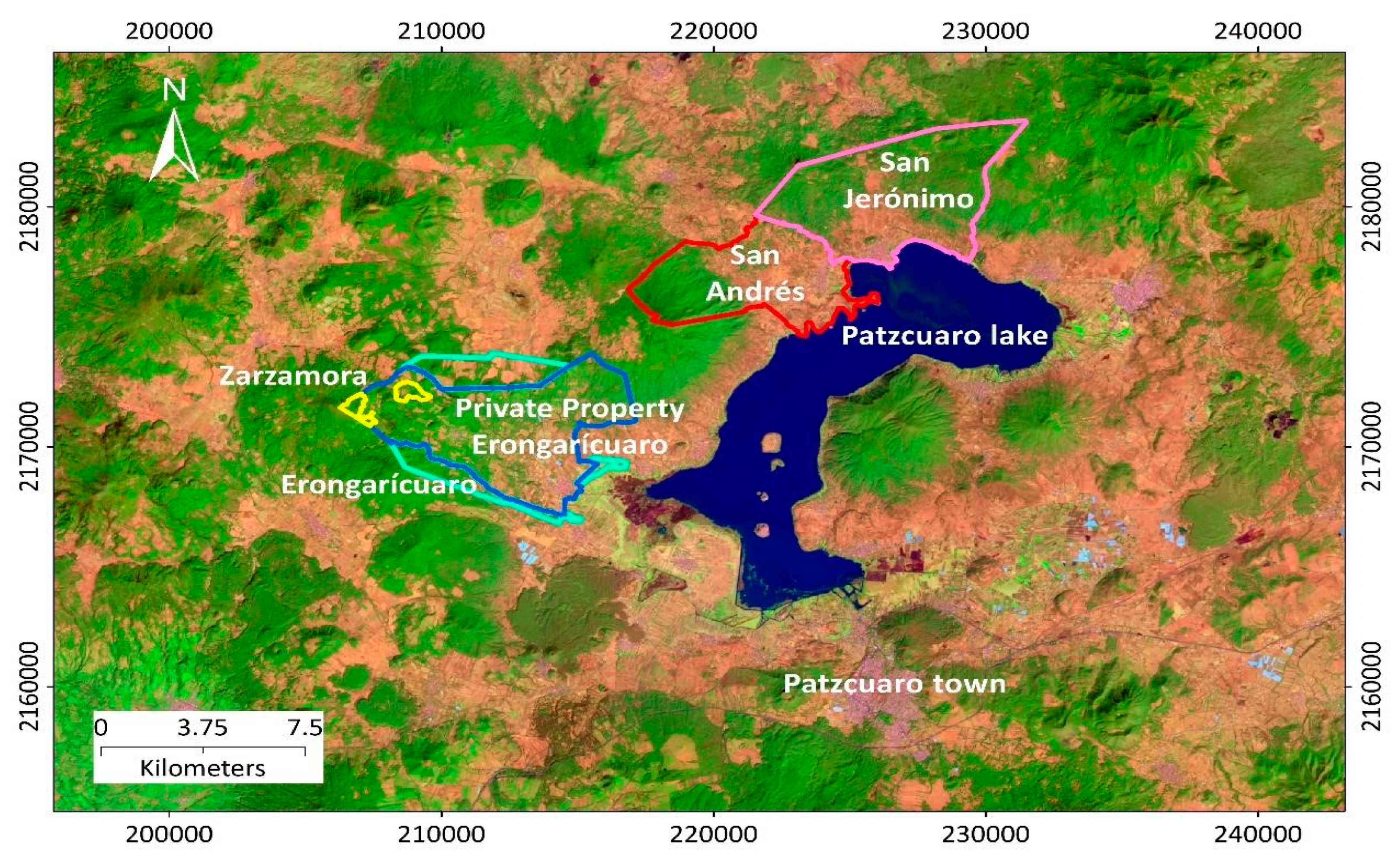
It is certain that the study area’s mobility patterns are consistent with farm closures. Although population dynamics are not observable at the locality level, insight can be gained with municipal data. Ejido Zarzamora, Ejido Erongarícuaro, and the private properties under analysis are found in Municipio Erongarícuaro, while the two indigenous communities—San Andrés and San Jerónimo—belong to Municipio Quiroga. Both Erongarícuaro and Quiroga grew during the period of NAFTA implementation (1990–2005), Erongarícuaro from 11,930 to 13,060 residents and Quiroga from 21,917 to 23,391. Dynamics affecting their rural and urban places differ, however. Of interest is Erongarícuaro’s declining rural population (from 11,930 to 10,593). This suggests that people are leaving the rural economy for better opportunities elsewhere, which could explain the FT in each of the three localities found here (private property and two ejidos).
Alternatively, Quiroga experienced rural population growth between 1990 and 2005 (from 3788 to 5735). Although annual cropping persists in a reduced area, FT follows the succession of secondary vegetation. Moreover, the growth in the rural population hardly suggests that the restoration of the forest has been driven by outmigration. For the notable case of San Jerónimo, FT evidently arises for reasons other than farm closure, perhaps from changes in household production involving intensification or from the replacement of maize produced locally for human consumption with purchased grains [25]. FT dynamics may also include a shift from wood to natural gas for cooking, although rural people in the area tend to continue to use firewood even after adopting natural gas options [55].
Although we cannot clearly link migration dynamics to the landcover changes we detected, it is clear that smallholder farming strategies throughout the region, and Mexico more generally, have changed appreciably in the wake of NAFTA and closely related institutional reforms. Maize agriculture has long been important to the PLW and still represents a key component of household farming [56]. Nevertheless, our study frame brackets the period during which PLW farmers began their engagement with the maize–beef complex, a vertically integrated system of maize suppliers, feedlots, and supermarkets [46]. Now found in all regions, this highly integrated production chain, which exports beef to global markets, is concentrated near cereal-producing regions in temperate central Mexico such as El Bajió, comprising the States of Guanajuato, Jalisco, and the state of the study area, Michoacan.
The adjustments in farm-level production followed trade liberalization, NAFTA, in particular, which stimulated a structural change in the Mexican cattle economy, specifically a switch from the grass-fed system of the hacienda to a complex supply chain based on feedlots, cheap imported grains, and expanding global markets for beef. As a consequence, new opportunities for smallholders have opened as suppliers of calves and feeders. Although the mixed farming systems in the PLW have long incorporated cattle in their production portfolio, the survey data reported by Astier et al. [46] for two of the study area municipalities (Erongarícuaro and Quiroga) revealed a substantial herd expansion from 589 animals at the start of their individual operations to 1760 animals in 2019 for 130 smallholder households. At the same time, the average household herd size grew from 5.8 to 14.5 animals. In accompaniment has been a shift in the role that bovines play in the household economy, with the sale of feeders to the supply chain replacing reproduction as the primary reason for maintaining cattle.
Prima facie, this might be expected to have placed pressure on forests to convert to pasture. Unfortunately, our remote sensing analysis was unable to identify pasture as a distinct land cover category, which is probably moot given the presence of FT. The explanation evidently lies in the availability of cheap corn and the use of household grains to feed the animals [41]. This could explain why the amount of land used for grazing has diminished over time across the sample, from 1236 to 1084 ha; a decline tracked by the household average from 8.64 to 7.52 ha [41]. Earlier, we suggested that land abandonment in Municipio Erongarícuaro is attributable to farm closures and economic difficulties. An alternative explanation is that cheap grains bought by the sale of feeders have diminished the household demand for annual production. Following NAFTA, family cow–calf operations no longer produce maize for local consumption. Evidently, old maize fields have been converted to pasture and secondary forests in which cattle graze. Supporting this possibility, and mitigating our inability to identify pastures with remote sensing, is the fact that smallholders in the PLW do not graze their animals on well-formed pastures, but rather in forests and secondary vegetation (agostadero).
As for the possible impact of the 1992 amendments to Article 27 of the Mexican Constitution, we call attention to the sharp distinction between private properties on the one hand and ejidos and indigenous communities on the other, with respect to the production of avocado. The amendment undid basic principles of the Mexican revolution as codified in Article 27, which established the inalienability of ejido lands, effectively transforming them into communal holdings, much like Indigenous communities’. After 1992 (and with the implementation of NAFTA), ejidatarios were able to privatize holdings subject to regulations and legal protocols. Only then could land be used as collateral to guarantee the loans necessary to invest in avocado. This could explain why nearly all avocado plantations are found on private holdings. There are other possible explanations, the analysis of which lies beyond the scope of this paper. For example, private properties may have incidentally formed on lands with enhanced capabilities (soils and topography). Alternatively, communal controls on farm practices might have inhibited commercial prospects.
The extent of avocado agriculture appears to be growing. Orozco-Ramírez and Astier [56] measured its expansion in the PLW for two municipalities in the present study. In Erongarícuaro, the avocado area grew from 8 hectares in 2003 to 211 hectares in 2014, and in Quiroga, from 5 to 73 hectares for the same period. In both cases, avocado areas grew at the expense of maize fields and the native forest of pine and oak. This rapid expansion is observable throughout the region. In the primary avocado-growing parts of Michoacán, associated land allocations increased from 3 to 34% of the total area, while fields for annual crops (mostly maize) shrank from 35 to 16%, and forests from 47 to 30% [57].
Our research documented a localized FT in the PLW, one that mirrors what is happening in the temperate forest biome across Mexico. This recovery of the forest area has occurred simultaneously with a significant structural change in regional agriculture. The old maize-oriented family farm appears to be giving way to more commercially oriented enterprises consisting of cow–calf operations, avocado plantations, or some combination of the two.

5. Conclusions

Economists and others often speculate about the link between resource management and land tenure. Bioeconomic theory has pointed to the superior performance of private property with respect to a variety of conservation outcomes [7]. It is argued that when resources are held in common, conservation-compatible incentives do not emerge. Although the theory has not been well articulated for the case of FT, it stands to reason that any kind of land cover change, to the extent it is driven by incentives, must bear some relationship to the land tenure situation. In the present case, the results are inconclusive. In absolute terms, private holdings dominate FT, affecting the native forest and accounting for about half of the new area captured by our analysis. However, one should not be too quick to conclude that FT is more likely to occur on private properties, which might be taken as the logical inference of bioeconomic theory and the incentives argument. Private property dominates in absolute terms, but its FT in relative terms (recovered native forest as a percentage of the land in private property) is 6%. For the case of Ejido Zarzamora, the relative FT is 20%; for Ejido Erongarícuaro, 5%; and for AC San Jerónimo, 5%. Although the AC of San Andrés shows no FT whatsoever, we note that our sample size forecloses an inferential conclusion, especially given the substantial variation in the relative rates across the communal properties.
FT research has called attention to the nature of the forest that returns to the landscape following the transition [7]. The hope is that the same ecosystem services, in the form of biodiversity maintenance and carbon sequestration, will be restored, but there is no guarantee. Our study reveals two confounding factors that weaken the prospects of such a beneficial outcome. The first is that Mexico’s temperate FT involves a hidden land use, namely the grazing of cattle under closed canopies. It is difficult to imagine that this would not significantly impact both biodiversity and forest biomass. Further, absent sound forest management practices, woodcutting, and timber harvesting are likely to remove commercially valuable species from the forest, which could degrade its ability to provide the ecosystem services that local people value. Evidently, such exploitation in the PLW is pushing the forest to one dominated by oak.
The second confounding factor involves tree crop production, avocado, in particular. Tree crops with closed canopies are forests of a type, and it may be difficult to classify them as a separate land cover when remotely sensed data do not possess sufficient resolution. Even with adequate resolution and a sure classification, an analyst might naively interpret avocado plantations as a type of forest for the simple fact that avocado plants are trees. Is there any harm in this, one might naturally wonder. Would it be wrong to conclude that the encroachment of avocado plantations on abandoned maize fields represents a type of FT? We argue that an answer should depend on the ledger of ecosystem services before and after the plantation matures. In the case of avocado, environmental harms outweigh its production of ecosystem services.
Of prime concern in the case of avocado are irrigation and pollution [58]. Irrigation, in which well-capitalized interests typically invest, disturbs the hydrological balance, thereby affecting the microclimate and surface water run-off patterns [59,60]. The use of manure and synthetic fertilizers—also used by large-scale operations—have been shown to eutrophy receiving water bodies, which are also impaired by run-off with pesticide residues. The negative externalities of land-use change involving a switch from the temperate pine–oak forest of the PLW to avocado plantations are well documented and clearly militate against counting avocado trees as adding to the positive side of the ecological ledger [60]. It should not be forgotten that avocado agriculture also produces a valuable commodity that could potentially generate higher income. Nevertheless, assessing the extent to which an economic activity promotes human welfare requires an accounting of all associated costs. Our analysis has pointedly equated forest with native forest, which a priori eliminates the possibility of making a definitional error that would lead to an overestimation of the study area’s FT.
Mexico’s National Contribution to the Paris Climate Treaty addresses the agricultural sector and forest management. Like other nations with large extant forests, Mexico recognizes the ecosystem service of carbon sequestration and consequently has crafted a mitigation approach involving the principles of UN-REDD. As already mentioned, this involves the policy objective of achieving 0% net deforestation by 2030. Such an objective may not seem far-fetched given the onset of FT in its temperate forests. One should be cautious, however, in concluding that this is the best possible outcome for the environment as a whole. An agroecological matrix of land uses may provide more ecosystem services than a recovering “forest” that is grazed or a new one that generates valuable commodities. The present study does not suggest the FT occurring in the PLW offers no environmental benefit, given that we have excluded avocado trees from the “forest” category. Further, the FT we have measured appears quite robust. It has prevailed against the structural changes induced by trade liberalization, involving a partial shift from maize-oriented agriculture to cow–calf operations and avocado plantations. Only time will tell if these new and profitable activities will reverse the multidecadal FT presently occurring in this part of Mexico.

Author Contributions

Author Contributions: C.S., M.A. and R.W. conceived the paper; C.S., M.A., R.W., J.F.N.-A. conceptualized and designed the research; Y.G.-M. prepared and analyzed national data; J.F.N.-A. prepared demographic data; Y.G. prepared and analyzed regional and Land Use Change data; C.S., M.A., R.W. and D.K. wrote, reviewed and edited the paper; M.A. and R.W. administered the project and obtained the resources. All authors have read and agreed to the published version of the manuscript.

Funding

This research was funded by the National Science Foundation entitled International Trade Agreements, Globalization, Land Change and Agricultural Food Networks, 2016–2019 and also by UNAM-DGAPA-PAPIIT (No. IN-200319), Project titled Análisis de la dinámica de sistemas mixtos agricultura-ganadería y sus impactos en la distribución de los recursos productivos, la diversidad de maíz y la configuración de los paisajes rurales en el Centro-Oeste de México.

Data Availability Statement

Not Applicable.

Conflicts of Interest

The authors declare no conflict of interest.

References

  1. Tubiello, F.N.; Salvatore, M.; Golec, R.D.C.; Ferrara, A.; Rossi, S.; Biancalani, R.; Federici, S.; Jacobs, H.; Flammini, A. Agriculture, Forestry and Other Land Use Emissions by Sources and Removals by Sinks; FAO Statistics Division: Rome, Italy, 2014. [Google Scholar]
  2. Sala, O.E.; Stuart Chapin, F., III; Armesto, J.J.; Berlow, E.; Bloomfield, J.; Dirzo, R.; Huber-Sanwald, E.; Huenneke, L.F.; Jackson, R.B.; Kinzig, A.; et al. Global Biodiversity Scenarios for the Year 2100. Science 2000, 287, 1770–1774. [Google Scholar] [CrossRef] [PubMed]
  3. Sunderlin, W.D.; Dewi, S.; Puntodewo, A.; Müller, D.; Angelsen, A.; Epprecht, M. Why Forests Are Important for Global Poverty Alleviation: A Spatial Explanation. Ecol. Soc. 2008, 13, 21. [Google Scholar] [CrossRef] [Green Version]
  4. Angelsen, A.; Rudel, T.K. Designing and Implementing Effective REDD+ Policies: A Forest Transition Approach. Rev. Environ. Econ. Policy 2013, 7, 91–113. [Google Scholar] [CrossRef]
  5. Barbier, E.B.; Delacote, P.; Wolfersberger, J. The Economic Analysis of the Forest Transition: A Review. J. For. Econ. 2017, 27, 10–17. [Google Scholar] [CrossRef]
  6. Mather, A.S. The Forest Transition. Area 1992, 24, 367–379. [Google Scholar]
  7. Walker, R. Deforestation and Economic Development. Can. J. Reg. Sci. 1993, 16, 481–497. [Google Scholar]
  8. Perz, S.G. Grand Theory and Context-Specificity in the Study of Forest Dynamics: Forest Transition Theory and Other Directions. Prof. Geogr. 2007, 59, 105–114. [Google Scholar] [CrossRef]
  9. Robbins, P.; Fraser, A. A Forest of Contradictions: Producing the Landscapes of the Scottish Highlands. Antipode 2003, 35, 95–118. [Google Scholar] [CrossRef] [Green Version]
  10. Barbier, E.B.; Burgess, J.C.; Grainger, A. The Forest Transition: Towards a More Comprehensive Theoretical Framework. Land Use Policy 2010, 27, 98–107. [Google Scholar] [CrossRef]
  11. Meyfroidt, P.; Rudel, T.K.; Lambin, E.F. Forest Transitions, Trade, and the Global Displacement of Land Use. Proc. Natl. Acad. Sci. USA 2010, 107, 20917–20922. [Google Scholar] [CrossRef] [Green Version]
  12. Pfaff, A.; Walker, R. Regional Interdependence and Forest “Transitions”: Substitute Deforestation Limits the Relevance of Local Reversals. Land Use Policy 2010, 27, 119–129. [Google Scholar] [CrossRef]
  13. Mendoza-Ponce, A.; Corona-Núñez, R.O.; Galicia, L.; Kraxner, F. Identifying Hotspots of Land Use Cover Change under Socioeconomic and Climate Change Scenarios in Mexico. Ambio 2019, 48, 336–349. [Google Scholar] [CrossRef] [PubMed] [Green Version]
  14. Walker, R. Forest Transition: Without Complexity, Without Scale. Prof. Geogr. 2008, 60, 136–140. [Google Scholar] [CrossRef]
  15. Bonilla-Moheno, M.; Aide, T.M. Beyond Deforestation: Land Cover Transitions in Mexico. Agric. Syst. 2020, 178, 102734. [Google Scholar] [CrossRef]
  16. Lorenzen, M.; Orozco-Ramírez, Q.; Ramírez-Santiago, R.; Garza, G.G. The Forest Transition as a Window of Opportunity to Change the Governance of Common-Pool Resources: The Case of Mexico’s Mixteca Alta. World Dev. 2021, 145, 105516. [Google Scholar] [CrossRef]
  17. Walker, R. The Scale of Forest Transition: Amazonia and the Atlantic Forests of Brazil. Appl. Geogr. 2012, 32, 12–20. [Google Scholar] [CrossRef]
  18. Song, X.-P.; Hansen, M.C.; Stehman, S.V.; Potapov, P.V.; Tyukavina, A.; Vermote, E.F.; Townshend, J.R. Global Land Change from 1982 to 2016. Nature 2018, 560, 639–643. [Google Scholar] [CrossRef] [PubMed]
  19. Mehrabi, Z.; Ellis, E.C.; Ramankutty, N. The Challenge of Feeding the World While Conserving Half the Planet. Nat. Sustain. 2018, 1, 409–412. [Google Scholar] [CrossRef] [Green Version]
  20. Perfecto, I.; Vandermeer, J. The Agroecological Matrix as Alternative to the Land-Sparing/Agriculture Intensification Model. Proc. Natl. Acad. Sci. USA 2010, 107, 5786–5791. [Google Scholar] [CrossRef] [Green Version]
  21. DeFries, R.; Rosenzweig, C. Toward a Whole-Landscape Approach for Sustainable Land Use in the Tropics. Proc. Natl. Acad. Sci. USA 2010, 107, 19627–19632. [Google Scholar] [CrossRef] [Green Version]
  22. Bada, X.; Fox, J. Persistent Rurality in Mexico and ‘the Right to Stay Home’. J. Peasant. Stud. 2022, 49, 29–53. [Google Scholar] [CrossRef]
  23. Hecht, S.; Yang, A.L.; Basnett, B.S.; Padoch, C.; Peluso, N.L. People in Motion, Forests in Transition: Trends in Migration, Urbanization, and Remittances and Their Effects on Tropical Forests; CIFOR: Bogor, Indonesia, 2015; ISBN 978-602-387-013-4. [Google Scholar] [CrossRef]
  24. Klooster, D. Environmental Certification of Forests: The Evolution of Environmental Governance in a Commodity Network. J. Rural. Stud. 2005, 21, 403–417. [Google Scholar] [CrossRef]
  25. Klooster, D. Forest Transitions in Mexico: Institutions and Forests in a Globalized Countryside. Prof. Geogr. 2003, 55, 227–237. [Google Scholar] [CrossRef]
  26. Aide, T.M.; Grau, H.R. Globalization, Migration, and Latin American Ecosystems. Science 2004, 305, 1915–1916. [Google Scholar] [CrossRef] [PubMed]
  27. Grau, H.R.; Aide, M. Globalization and Land-Use Transitions in Latin America. Ecol. Soc. 2008, 13, 12. [Google Scholar] [CrossRef] [Green Version]
  28. Ramírez-Delgado, J.P.; Christman, Z.; Schmook, B. Deforestation and Fragmentation of Seasonal Tropical Forests in the Southern Yucatán, Mexico (1990–2006). Geocarto Int. 2014, 29, 822–841. [Google Scholar] [CrossRef]
  29. Rudel, T.K.; Perez-Lugo, M.; Zichal, H. When Fields Revert to Forest: Development and Spontaneous Reforestation in Post-War Puerto Rico. Prof. Geogr. 2000, 52, 386–397. [Google Scholar] [CrossRef]
  30. Hecht, S.B.; Saatchi, S.S. Globalization and Forest Resurgence: Changes in Forest Cover in El Salvador. BioScience 2007, 57, 663–672. [Google Scholar] [CrossRef] [Green Version]
  31. Perz, S.G.; Skole, D.L. Secondary Forest Expansion in the Brazilian Amazon and the Refinement of Forest Transition Theory. Soc. Nat. Resour. 2003, 16, 277–294. [Google Scholar] [CrossRef]
  32. Hecht, S. The New Rurality: Globalization, Peasants and the Paradoxes of Landscapes. Land Use Policy 2010, 27, 161–169. [Google Scholar] [CrossRef]
  33. Hernández-Aguilar, J.A.; Durán, E.; de Jong, W.; Velázquez, A.; Pérez-Verdín, G. Understanding Drivers of Local Forest Transition in Community Forests in Mixteca Alta, Oaxaca, Mexico. For. Policy Econ. 2021, 131, 102542. [Google Scholar] [CrossRef]
  34. Vaca, R.A.; Golicher, D.J.; Cayuela, L.; Hewson, J.; Steininger, M. Evidence of Incipient Forest Transition in Southern Mexico. PLoS ONE 2012, 7, e42309. [Google Scholar] [CrossRef] [PubMed]
  35. Rudel, T.K.; Bates, D.; Machinguiashi, R. A Tropical Forest Transition? Agricultural Change, Out-Migration, and Secondary Forests in the Ecuadorian Amazon. Ann. Assoc. Am. Geogr. 2002, 92, 87–102. [Google Scholar] [CrossRef]
  36. Schmook, B.; Radel, C. International Labor Migration from a Tropical Development Frontier: Globalizing Households and an Incipient Forest Transition. Hum. Ecol. 2008, 36, 891–908. [Google Scholar] [CrossRef]
  37. Mesa-Sierra, N.; de la Peña-Domene, M.; Campo, J.; Giardina, C.P. Restoring Mexican Tropical Dry Forests: A National Review. Sustainability 2022, 14, 3937. [Google Scholar] [CrossRef]
  38. López, E.; Bocco, G.; Mendoza, M.; Velázquez, A.; Rogelio Aguirre-Rivera, J. Peasant Emigration and Land-Use Change at the Watershed Level: A GIS-Based Approach in Central Mexico. Agric. Syst. 2006, 90, 62–78. [Google Scholar] [CrossRef]
  39. Barsimantov, J.; Navia-Antezana, J. Land Use and Land Tenure Change in Mexico’s Avocado Production Region: Can Community Forestry Reduce Incentives to Deforest for High Value Crops? In Proceedings of the Twelfth Biennial Conference of the International Association for the Study of the Commons, Cheltenham, UK, 14–18 July 2008.
  40. Barsimantov, J.; Navia Antezana, J. Forest Cover Change and Land Tenure Change in Mexico’s Avocado Region: Is Community Forestry Related to Reduced Deforestation for High Value Crops? Appl. Geogr. 2012, 32, 844–853. [Google Scholar] [CrossRef]
  41. Galvan-Miyoshi, Y.; Walker, R.; Warf, B. Land Change Regimes and the Evolution of the Maize-Cattle Complex in Neoliberal Mexico. Land 2015, 4, 754–777. [Google Scholar] [CrossRef]
  42. Perramond, E.P. The Rise, Fall, and Reconfiguration of the Mexican Ejido*. Geogr. Rev. 2008, 98, 356–371. [Google Scholar] [CrossRef]
  43. Siyum, Z.G. Tropical Dry Forest Dynamics in the Context of Climate Change: Syntheses of Drivers, Gaps, and Management Perspectives. Ecol. Process. 2020, 9, 25. [Google Scholar] [CrossRef]
  44. Blackie, R.; Baldauf, C.; Gautier, D.; Gumbo, D.; Kassa, H.; Parthasarathy, N.; Paumgarten, F.; Sola, P.; Pulla, S.; Waeber, P.; et al. Tropical Dry Forests: The State of Global Knowledge and Recommendations for Future Research; CIFOR: Bogor, Indonesia, 2014. [Google Scholar]
  45. Geografía (INEGI), I.N. de E. y Mapas. Uso de Suelo y Vegetación. Available online: https://www.inegi.org.mx/temas/usosuelo/ (accessed on 21 March 2023).
  46. Astier, M.; Orozco-Ramírez, Q.; Walker, R.; Galván-Miyoshi, Y.; González-Esquivel, C.; Simmons, C.S. Post-NAFTA Changes in Peasant Land Use—The Case of the Pátzcuaro Lake Watershed Region in the Central-West México. Land 2020, 9, 75. [Google Scholar] [CrossRef] [Green Version]
  47. Barrera-Bassols, N.; Alfred Zinck, J.; Van Ranst, E. Symbolism, Knowledge and Management of Soil and Land Resources in Indigenous Communities: Ethnopedology at Global, Regional and Local Scales. CATENA 2006, 65, 118–137. [Google Scholar] [CrossRef]
  48. Torres, A.C. Lake Patzcuaro, Mexico: Watershed and Water Quality Deterioration in a Tropical High-Altitude Latin American Lake. Lake Reserv. Manag. 1993, 8, 37–47. [Google Scholar] [CrossRef] [Green Version]
  49. Klooster, D. Beyond Deforestation: The Social Context of Forest Change in Two Indigenous Communities in Highland Mexico. Conf. Lat. Am. Geogr. Yearb. 2000, 26, 47–59. [Google Scholar]
  50. Grainger, A. National Land Use Morphology: Patterns and Possibilities. Geography 1995, 80, 235–245. [Google Scholar]
  51. Forest Resources Assessment 1990—Survey Tropical Forest Cover Studies of Change Processes. Available online: https://www.fao.org/3/w0015e/w0015e00.htm (accessed on 20 February 2023).
  52. Población, C.N. de Índices de marginación 2020. Available online: http://www.gob.mx/conapo/documentos/indices-de-marginacion-2020-284372 (accessed on 20 February 2023).
  53. Consejo Nacional de Población (CONAPO). Available online: http://www.conapo.gob.mx/work/models/CONAPO/Marginacion/Datos_Abiertos/Script_Indice_de_marginacion_por_localidad_2020.txt (accessed on 20 February 2023).
  54. National Agrarian Registry, Mexican Government Registro Agrario Nacional-PHINA-Padrón e Historial de Núcleos Agrarios. Available online: https://phina.ran.gob.mx/consultaPhina.php (accessed on 20 February 2023).
  55. Ruiz-Mercado, I.; Masera, O. Patterns of Stove Use in the Context of Fuel–Device Stacking: Rationale and Implications. EcoHealth 2015, 12, 42–56. [Google Scholar] [CrossRef]
  56. Orozco-Ramírez, Q.; Astier, M. Socio-Economic and Environmental Changes Related to Maize Richness in Mexico’s Central Highlands. Agric. Hum. Values 2017, 34, 377–391. [Google Scholar] [CrossRef]
  57. Morales-Manila, L.M.; Reyes-González, A.; Cuevas-Garcia, G.; Onchi-Ramuco, M. Inventario 2011 Del Cultivo Del Aguacate En El Estado de Michoacán; Centro de Investigaciones en Geografía Ambiental, UNAM–COFUPRO: Morelia, Mexico, 2012. [Google Scholar]
  58. Bravo-Espinosa, M.; Mendoza, M.E.; CarlóN Allende, T.; Medina, L.; Sáenz-Reyes, J.T.; Páez, R. Effects of Converting Forest to Avocado Orchards on Topsoil Properties in the Trans-Mexican Volcanic System, Mexico. Land Degrad. Dev. 2014, 25, 452–467. [Google Scholar] [CrossRef]
  59. Chavez, A.G.T.; Morales-Chávez, R.; García-González, Y.; Francisco, A.; Rojas, G.T. T. Partición de La Precipitación En Cultivo de Aguacate y Bosque de Pino-Encino En Michoacan, Mexico. Biológicas 2020, 21, 1–18. [Google Scholar]
  60. Quiroz Rivera, F. Comparación del Consumo Hídrico entre Persea Americana y Pinus Pseudostrobus. Ph.D. Thesis, Universidad Michoacana de San Nicolás de Hidalgo, Morelia, Mexico, 2019. [Google Scholar]
Figure 1. Forest change magnitudes 1985–2018 km2 [45]. Five study sites in PLW, located in Michoacán state, central Mexico.
Land 12 00840 g001
Figure 2. Map of the study area.
Land 12 00840 g002
Figure 3. Five study sites in PLW, located in Michoacán state, central Mexico.
Land 12 00840 g003
Table 1. Characteristics of localities in study region.
AC
San Andrés
AC
San Jerónimo
Ejido
Erongarícuaro
Ejido
Zarzamora
Private Property
Erongarícuaro
Population:
Total a2418198198313639
Indigenous a24181981unknownunknownunknown
Poverty aMediumVery LowVery LowVery LowVery Low
Area (ha):
Initial Size b2621.43146.8648.0117.7NA
Current Size csamesame1045.0sameNA
Resolution b
Initial date
26 August 199722 September 197514 January 19183 February 1961NA
PROCEDE c
Current date
15 May 200624 September 200224 July 200230 June 1997NA
Sources: a Consejo Nacional de Poblacion, Mexico [52,53]; b Presidential Resolution of Communal and Ejido [54]; c Program Certificación de Derechos Ejidales y Titulación de Solares—PROCEDE [54].
Table 2. (a) The area of land use and land cover changes from 1996–2018. (b) Land use transition from 1996 to 2018.
a
Land Use
Categories
Areas in 1996 (ha)Areas in 2018 (ha)Change
Area (ha)
Annual crop3872.193324.99−547.2
Temperate forest5448.35883.32+435.02
Tree crops5.51228.87+233.36
Secondary vegetation956.05771.96−184.09
Urban zone278.88351.80+72.92
b
Land Use 2018 (ha)
Land Use
1996 (ha)
Annual CropForestTree CropsSecondary VegetationUrban AreasTotal
Annual crop3293.47280.58101.95125.0571.143872.19
Forest9.355334.0985.8918.370.615448.30
Tree crop0.73 4.29 0.505.51
Secondary vegetation21.44268.6536.74628.540.67956.05
Urban areas 278.88278.88
Total3324.995883.32228.87771.96351.80
Disclaimer/Publisher’s Note: The statements, opinions and data contained in all publications are solely those of the individual author(s) and contributor(s) and not of MDPI and/or the editor(s). MDPI and/or the editor(s) disclaim responsibility for any injury to people or property resulting from any ideas, methods, instructions or products referred to in the content.

