Review

Fit-for-Purpose Land Administration and the Framework for Effective Land Administration: Synthesis of Contemporary Experiences

by
Mekonnen Tesfaye Metaferia
1,*,
Rohan Mark Bennett
1,2,3,
Berhanu Kefale Alemie
4 and
Mila Koeva
5
1
Space Science and Geospatial Institute (SSGI), Addis Ababa P.O. Box 33679/597, Ethiopia
2
School of Business, Law and Entrepreneurship, Swinburne University of Technology, John Street, Hawthorn, VIC 3122, Australia
3
Kadaster, The Netherlands Cadastre, Land Registry and Mapping Agency, 7311 KZ Apeldoorn, The Netherlands
4
Institute of Land Administration, Bahir Dar University, Bahir Dar P.O. Box 79, Ethiopia
5
Faculty of Geo-Information Science and Earth Observation (ITC), University of Twente, 7514 AE Enschede, The Netherlands
*
Author to whom correspondence should be addressed.
Land 2023, 12(1), 58; https://doi.org/10.3390/land12010058
Submission received: 16 November 2022 / Revised: 19 December 2022 / Accepted: 21 December 2022 / Published: 25 December 2022
(This article belongs to the Special Issue Land, Innovation and Social Good 2.0)

Abstract

:
Despite the significant and explicit focus on the United Nations Sustainable Development Goals (SDGs), much of the world’s land rights remain unrecorded and outside formal government systems. Blame is often placed on land administration processes that are considered slow, expensive, and expertise-dependent. Fit-For-Purpose Land Administration (FFPLA) has been suggested as an alternative, time and cost-effective approach. Likewise, the UN endorsed Framework for Effective Land Administration (FELA) demands attention to worldwide tenure insecurity by directly linking it to responsible land administration. Implementation of FFPLA and FELA is country-context dependent, and there are now many lessons of execution from various jurisdictions. Undertaken in 2022, this study synthesizes a review of experiences to provide a further update on the best global FFPLA implementation practices and inform approaches for future FFPLA projects. A systematic review is adopted as the research methodology, and contemporary articles from the internationally recognized land administration discourse are examined. The studies focus on FFPLA implementation practices and innovative approaches for delivering land tenure security. A checklist is developed, based on the FELA strategic pathways and the FFPLA fundamental framework principles and characteristic elements, to identify best implementation practices. Success stories across the globe show that the FFPLA characteristic elements and the FELA pathway goals are achieved through effective execution of the FFPLA framework key principles. As a result, the study identified successful FFPLA implementation practices in Asia and Africa, which can be synthesized and extended to realize tenure security in rapidly urbanizing areas. However, further study is necessary to determine the efficacy, practicability, innovativeness, and transferability of the best practices to other land administration scenarios.

1. Introduction

Conventional land administration systems focus on protecting land tenure security and supporting the land market [1,2]. Identifying parcel boundaries and areas for revenue has been a long-standing practice that dates back millennia. It laid the foundation for the modern era of land administration that supports more functions: land use, land value, land development, and land tenure [2,3].
Despite the long-standing tenure security function of land administration practices, studies estimate a significant proportion of the world’s land rights are undocumented, owing partly to the slow, expensive, and expertise-dependent cadastral surveying and land registration conventional approach [4,5]. Additionally, high rates of urbanization have been challenging land tenure recordation for the past few decades [6,7,8].
In response, the United Nations Committee of Experts on Global Geospatial Information Management [9] developed the Framework for Effective Land Administration (FELA) to support the achievement of Sustainable Development Goals (SDGs) in the land sector [5]. It enables benchmarking to track member states’ progress on land rights security [10]. This is part of the broader push to achieve the SDGs that seek to improve people’s lives while safeguarding the environment [11]. The SDGs aim at solutions to the broader global challenges caused by a lack of good land governance and efficient land administration systems [12]. Land governance is the spatial dimension of governance that refers to the sustainable and transparent management of land, property, and natural resources [2,13].
FELA highlights that conventional approaches to land administration can be slow and cost-inefficient in dealing with the rapid urbanization challenges [14]. Enemark et al. [12] also argue that it would take decades to achieve the SDGs and ensure global tenure security through the conventional land administration approach. Thus, different countries are executing Fit-For-Purpose Land Administration (FFPLA), with a primary focus on delivering tenure security in an expedited fashion [15].
Although the FFPLA approach and its executions are country-context dependent, these specific applications could provide practical experience for addressing land administration challenges of other developing nations. They can also help extend conceptual improvements concerning the spatial, legal, and institutional framework of FFPLA, and its broader applicability for effective land administration. Most recent work has been completed in this regard, in terms of assessing and documenting FFPLA cases. However, most of this work was completed before the outbreak of COVID-19 pandemic and pre-FELA eras, and more cases have emerged in the intervening years. Although COVID-19 has influences on land administration issues, studies discourse the FFPLA approach could help improve resilience to climate and pandemic-related impacts, necessitating responsive actions to maintain the SDGs [16,17].
Therefore, the purpose of this study is to identify successful global FFPLA practices and theories implemented in 2021 and 2022 that can be synthesized and extended for applicability in other land administration settings, such as rapidly urbanizing areas of the developing nations. The best FFPLA implementation practices in the study refer to the successful take-up of FFPLA executions that inform approaches for future FFPLA projects. Accordingly, the review will explore (i) how countries have contextualized and mainstreamed FFPLA implementation; (ii) how countries have addressed FELA through FFPLA during project implementation; (iii) to what extent can FELA and FFPLA be jointly pursued during project implementation, and (iv) how emerging innovations enhance FELA and FFPLA executions.
In the remaining sections, a comprehensive view of FELA and FFPLA is presented first as a background for the study. Then, the methodological approach for the study is briefly discussed. Next, a review of the contemporary innovative and conceptual FFPLA implementation practices is offered, followed by a detailed discussion and synthesis of the results. Finally, the study conclusion and recommendations are presented.

2. Background

2.1. Framework for Effective Land Administration (FELA)

The Framework for Effective Land Administration (FELA) is a high level, strategic framework that serves as a reference for UN member state countries while building, improving, monitoring, and evaluating their land administration solutions [5,9]. Forty-four countries across the globe (ten from Asia, ten from the Americas, eight from Africa, fifteen from Europe, and one from Arab states) have actively contributed to the development of FELA, and currently it is translated into different languages for ease of use [18]. FELA aims to combat worldwide tenure insecurity through rapid and sustainable land administration actions that consider all people. It is designed based on the overarching and strategic Integrated Geospatial Information Framework (IGIF) [9]. FELA has nine interrelated and necessarily overlapping pathways to guide its execution and achieve the land related SDGs. These are Governance, Institutions and Accountability, Legal and Policy, Financial, Data, Innovation, Standards, Partnerships, Capacity and Education, and Advocacy and Awareness [5,9].
The pathways serve as a guide for meeting the requirements and achieving the overall FELA goals. Table 1 shows the requirements to achieve the goals through the pathways. FELA makes direct reference to the underlying pragmatic philosophy, elements, and guidance of FFPLA.

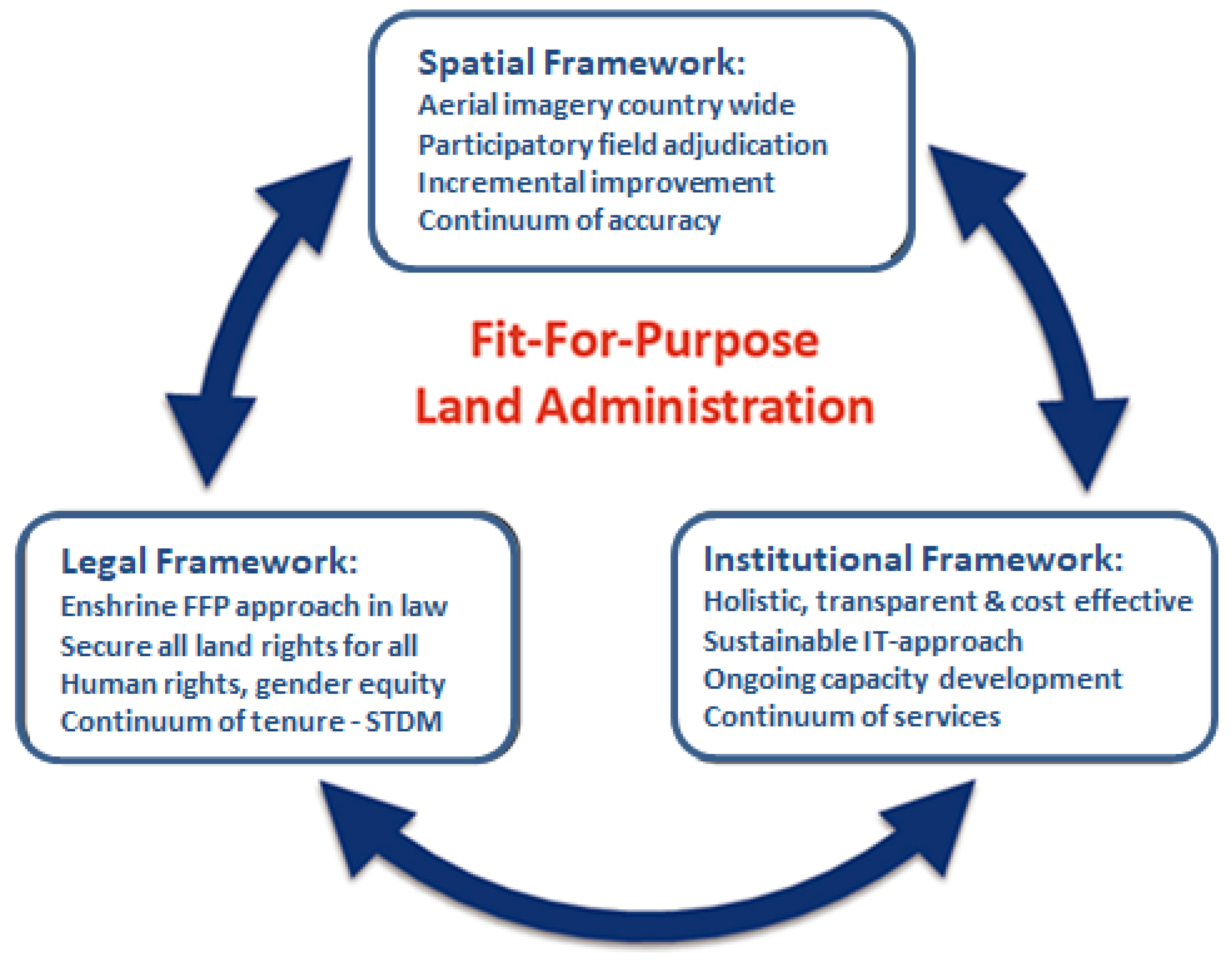
2.2. The Fit-For-Purpose Land Administration (FFPLA) Concept

Preceding FELA, the FFPLA approach, with similarities to the “Minimum Viable Product” (MVP) philosophy, proposes to create an entry point for addressing the basic societal needs of tenure security that would upgrade with quality and scope over time [12,13]. The fit-for-purpose concept is best explained in Enemark et al. [14] as “as little as possible–as much as necessary”. The approach can be tailored to a country’s specific tenure security strategies and does not depend on cutting-edge technology and lengthy field surveys.
The FFPLA approach is seen as a top-down execution that entails forging alliances, launching projects, and enhancing capability within the ranks of the executive branch [13,19]. The strategy and methods of implementation will also differ depending on the nation, the kind of tenure, the type of land use, the topography, and the density of parcels [14]. It is a participatory approach for recording parcel information with inexpensive technologies, striving for complete coverage first [5,20]. For instance, as an alternative to conventional aerial photography, UAVs could be applied for updating the rapidly changing (peri-) urban areas’ land administration. High-resolution satellite imagery is an alternative data source for cadastral base mapping and updating. GNSS-enabled smartphones enhanced the notion of crowdsourcing for mapping and updating own land rights. Automatic parcel boundary extraction from images becomes promising with artificial intelligence and machine learning developments [5,20,21]. Compared to the conventional field surveying and aerial photography procedures, these technologies are: flexible in terms of use, inexpensive to purchase, work in all terrain types and environments, encourage local participation and engagement, and deliver reliable information to meet the current demand and upgrade to satisfy future needs [22].
The FFPLA concept gained traction as an alternative to the conventional approach after the first joint publication by the FIG and the World Bank in 2014 [15]. The development of the ISO 19,152 Land Administration Domain Model (LADM) in 2012, accompanied by the Social Tenure Domain Model (STDM), also contributed to its quick acceptance [20].
FFPLA has seven characteristic elements (Table 2) and three fundamental frameworks (spatial, legal, and institutional) (Figure 1). The purpose of FFPLA is to ensure tenure security that meets the desirable qualities (the characteristic elements) of the approach through a simplified spatial, legal, and institutional framework—the building blocks [23].
According to Enemark et al. [12,14], the spatial framework establishes a cost-effective and feasible method of dividing land into spatial units and is a foundation for registering land rights. The legal framework provides fit-for-purpose innovative and flexible land right registration techniques that need legal endorsement. The institutional framework proposes policy frameworks for an efficient and accountable institutional setup to deliver transparent and accessible land information for all.

2.3. FFPLA and FELA Alignment

The FELA pathways align with the FFPLA approach. For example, FELA’s transparency and accountability are the foundations of the FFPLA institutional framework. Moreover, the continuum of tenure [12] ensures land and property rights for all, inclusive of gender and vulnerable groups. Affordable investments and economic returns can be ensured by flexible ICT solutions and open-source technologies, in addition to implementing a sustainable business model. Reliable data can be generated from satellite/aerial image visible boundaries, focusing on the purpose rather than technical standards. Innovative updating and upgrading approaches are encouraged for ongoing improvements responsive to societal needs and economic growth. The ISO-endorsed LADM and the derived STDM confirm an adaptable interoperability layer with other stakeholders. Institutional collaboration and partnership are targeted toward supporting the recording and maintenance of land rights evidence, leveraging the private sector’s capacity, knowledge, and finance in the land sector. Capacity development and knowledge transfer bring new skills to the public and private sectors to enhance implementation. Advocacy and awareness are included to establish national engagement and commitment at the societal, organizational, and individual levels. Although FFPLA was conceived before FELA, there is a strong alignment between them. Table 3 depicts the FFPLA alignment with the FELA pathway goals, adapted from [9,14].

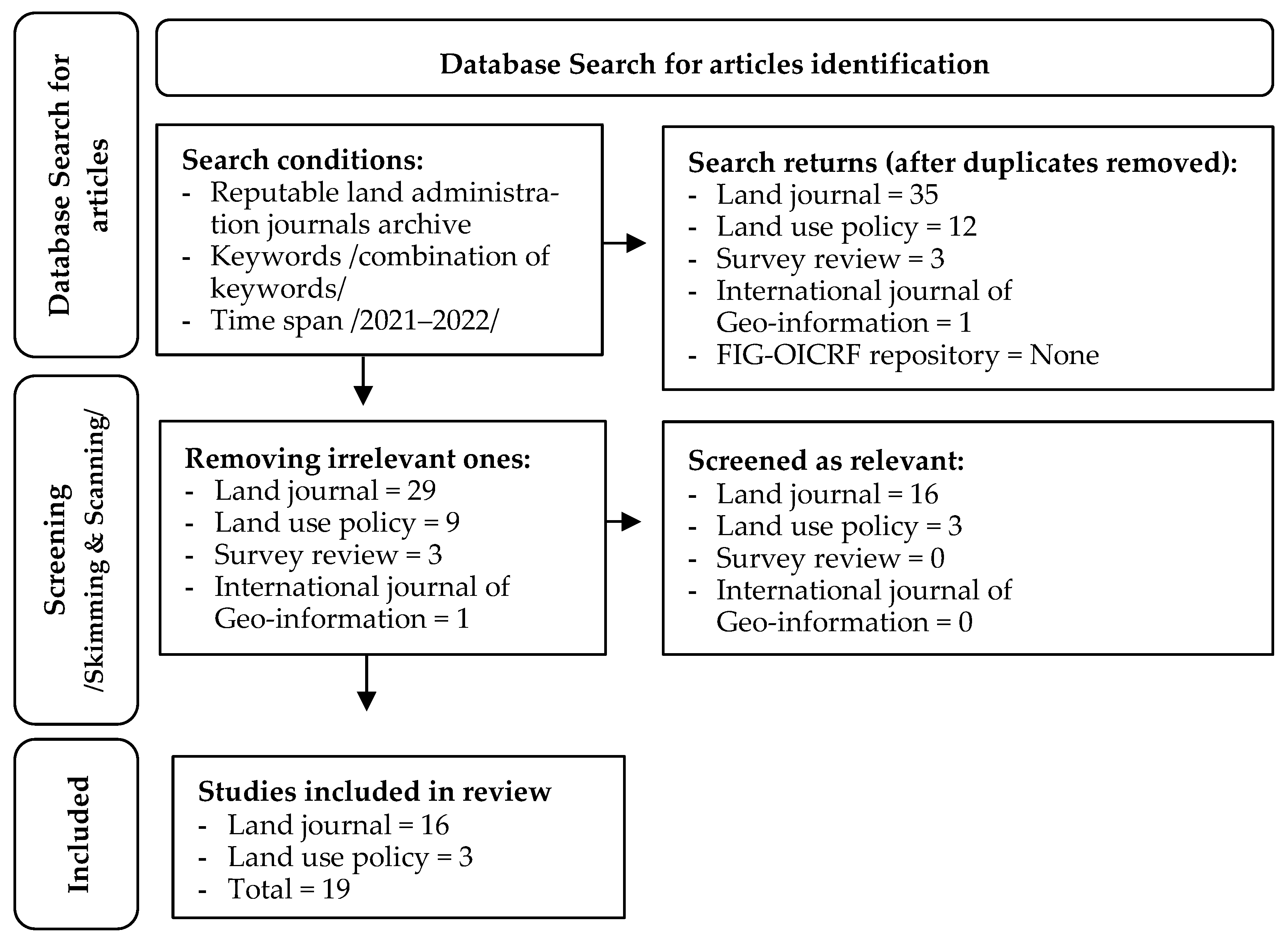
3. Materials and Methods

The execution of the FFPLA and implementation of FELA approach varies from country to country based on the prevailing and available spatial, legal, and institutional frameworks. However, it is conceivable to identify successful implementations and developments and create generalization to extrapolate from and apply to other land administration settings.
The constructivist/interpretivist research paradigm is identified as a framework for the study. It seeks a deeper understanding of a concept and tends to develop subjective meanings for experiences [24]. The paradigm is helpful in discerning background knowledge to subsequently improve practices, besides encompassing numerous methodologies to achieve the research objectives [25]. Following from this, a systematic review is adopted as the overarching research methodology, an approach for identifying, analyzing, and integrating relevant study outputs on a subject topic to address a specific research question or hypothesis [26,27]. Different authors such as [20,28,29,30] use this approach in the land administration domain studies.
The study is purposely confined to recent studies and focuses on contemporary FELA and FFPLA developments following emerging geospatial technologies. Furthermore, earlier FFPLA practices, such as those in Ethiopia and Rwanda, are well explored, and insights that contributed to today’s innovative approaches are extracted [15,31,32,33]. That said, as for the first task of the systematic research approach, i.e., searching and identifying relevant literature, the study employs already acknowledged literature by Enemark et al. [10], for both FFPLA conceptual innovations (Volume I) and practical implementations (Volume II) across the globe. All the articles were published in 2021 in the Land Journal, an international scholarly and open-access journal that focuses on land use and land management issues.
However, the search for articles is extended to other renowned and reputable land administration journals: Land Use Policy (LUP), Survey Review (SR), and International Journal of Geo-Information (IJGI). The Land journal is also double-checked to maximize the possibility of receiving relevant papers that might not be included in the two volumes of publications. Further searches are conducted in the OICRF (https://www.oicrf.org/, accessed on 5 July 2022) archive of the International Federation of Surveyors (FIG). Figure 2 is the flow diagram for the identification of studies from the reputable journals and the OICRF databases (adapted from PRISMA1).
Multiple searches were run in the first week of July 2022 for the Science Direct, Taylor & Francis, MDPI, and OICRF repositories with the same periods (2021 to 2022) and keyword combinations (‘conceptual’, ‘innovative’, ‘Fit for purpose’, ‘land administration’, ‘cadaster’, ‘country implementations’, ‘executions’, ‘tenure security’, ‘geospatial tools’, ‘public-private partnership’, ‘maintenance’, ‘update/upgrade’, ‘feature’, ‘boundary’, ‘extraction’, ‘delineation’). The keywords (combined by ‘AND’/‘OR’) are expected to provide studies relevant to the Enemark et al. [10] collections on the FFPLA conceptual and technical innovations.
The search yielded thirty-five (35) articles from Land (including the items in the two volumes), twelve (12) papers from LUP, three (3) from SR, and one (1) from IJGI. The search for the FIG-OICRF repository delivered no results. Non-relevant publications are weeded out by swiftly skimming and scanning (probing a bit deeper) the title and abstract of each article, a time-honored approach to quickly reviewing and getting the substance of a document [34]. Thus, a total of 19 articles from the Land (16) and LUP (3) journals are identified, which focus on FFLA practical country implementations (13) and conceptual innovations (6), and thoroughly examined (Figure 2).
The overall methodological approach to identify the best FFPLA implementation practice is depicted in Figure 3.
Based on the review, the countries’ responses to the FFPLA core principles and FELA pathway goals are collected using a checklist for ease of further comparison to characterize successful executions, as done in multiple works [35,36,37,38,39,40]. For instance, van der Molen et al. [40] compared nine African countries to identify how land policy documents are composed. Kitsakis et al. [35] comparatively analyzed and depicted the legal concepts for 3D real property in selected case study countries. Augustinus [36] compared and identified land administration best practices in five countries.
FELA is utilized to examine and describe land administration situations. For instance, Bennett et al. [20] applied the nine paths to discover and link land administration maintenance concerns with available solutions. García-Morán et al. [41] employed the FELA pathways to determine the roles and responsibilities of the involved actors in securing land rights while developing an innovative public-private partnership. Thus, the FELA nine pathways are utilized to explore global implementation of the FFPLA fundamental framework key principles. Best practices are anticipated to achieve the FFPLA desirable qualities and meet the FELA goals. Furthermore, conceptual innovations in spatial, legal, and institutional frameworks are being investigated to extend enhanced FFPLA implementation practices to a broader range of land administration settings (Figure 3).

4. Results

Although the primary concern of FFPLA is resolving the global land tenure security issues, currently, it is expanding to address the other fundamental functions of land administration (land value, land use, and land development) [13]. The approach strives to achieve a flexible, inclusive, participatory, affordable, reliable, attainable, and upgradeable land administration system through the key principles of the fundamental framework. Several studies agree with the benefits of the FFPLA for ensuring tenure security in a short period and at a reasonable cost [10,42].
The UN-endorsed FELA guides member countries in building, improving, or monitoring their land administration systems. It could be aligned with the FFPLA approach and enhance its implementation, thereby achieving the FELA pathway goals. Furthermore, emerging innovations and ICT solutions promote the FFPLA approach by providing inexpensive, reliable, and faster tools for tenure mapping and security services [13,43]. Best FFPLA implementation practices are anticipated to integrate and realize FELA pathways and FFPLA framework principles, supported by FELA/FFPLA-focused contemporary innovations and conceptual developments.
The review results are presented according to the study flow depicted in the research methodology (Figure 3). First it describes the status of FFPLA on a global scale through the summary of the widespread contemporary FFPLA implementation practices. The result further demonstrates how the FELA pathway goals enhance the execution of the FFPLA fundamental framework principles and, conversely, how FFPLA aids in achieving FELA goals. Successful application of the FFPLA principles realizes its characteristic elements in land administration practice. FELA/FFPLA focused innovative concepts and technologies are also helping secure land ownership rights in a fit-for-purpose manner. FELA and FFPLA collaborate to provide the best implementation practices, which are discerned based on the countries’ achievements in meeting the FELA pathway goals and the FFPLA fundamental framework principles.

4.1. Mainstreaming of FFPLA Implementation Practices

Global donors and development partners, such as the World Bank, are now requesting that the FFP approach be used in project designs to support land administration projects [9,44]. However, even before the FFPLA approach got global attention (pre-2010), some African and Asian countries used a cost-and time-effective method to improve their land administration and management systems. Byamugisha [45] reviewed land administration executions in China and Vietnam and compared them with two remarkable practices carried out by Ethiopia and Rwanda.
The central government of China scaled up a land registration project initiation started by one province in 2005 that covered the registration and certification of about 98.87 million hectares of rural land across the country. The approach was participatory and employed high-resolution satellite imagery and ground surveys for highly-valued contractual land use rights. Vietnam started a participatory land right registration and land use right certification in 1994 that involved all levels of the government down to the local community representatives. After six years, it was possible to issue land use rights certificates for about 90 percent of the rural land and 16 percent of the urban areas. In five years, Rwanda demarcated, adjudicated, and registered all the nation’s rural and urban land parcels at an estimated cost of USD 8 per parcel. Ethiopia also issued the second-level certification for about 20 million rural landholdings within six-years at an average cost of USD 8.5 per parcel.
These Asian and African countries land registration and certification success stories are due to their pragmatic strategy and participatory approach encompassing all levels of government, from provincial to district to commune [45]. After the FFPLA concept has gained global acceptance, its implementation is increasing across a broader range of land management functions [13], pending accuracy, and high-tech demands for overtime improvement.

4.1.1. FFPLA, Improving the Existing Tenure Security Practices

Mozambique has implemented the FFPLA after facing several data quality issues in addition to the time and budget-intensive nature of the conventional method [46]. The registration approach involved connecting people, processes, and technology for accurate and complete data collection while saving cost and time. Community participation, inexpensive technologies, and user-friendly applications are common to most FFPLA implementation practices, such as in Uganda, Kenya, Zambia [47], Nepal [48], Colombia [49,50], and Benin [51].
Another study by Chigbu et al. [52] examined successful FFPLA implementation in Ghana, Kenya, and Namibia. It was executed to secure land rights in different land administration settings: peri-urban (Kenya), urban (Namibia), and rural (Ghana). The study evaluated these implementations in light of the fundamental principles of FFPLA. Namibia adopted the FFPLA principles but with a fixed boundary approach. However, according to Martono et al. [53], the “fixed-boundary” approach is time and resource consuming for it needs establishing monuments and determining the coordinates with accurate positioning techniques. Ghana and Kenya also exercised many of the framework principles well, with considerable attention to administrative flexibility, gender equity, good governance, and institutional integration.
Martono et al. [53] proposed a fit-for-purpose approach to Indonesia’s ambitious plan for systematic registration of 135 million parcels, which is falling behind schedule owing to spatial and legal constraints. According to the study, the legal requirement for a high-precision “fixed-boundary” survey over erected boundary monuments caused poor development. The cost of preparing the monuments has also made registration too expensive. Although the “fixed-boundary” approach is implemented in Benin [51] and Namibia [50], Martono et al. [53] recommended the “general-boundary” for cost and time effective parcel boundary delineation, setting aside the fixed boundary approach for future enhancement and upgrading, as proposed in the FFPLA approach.
Becerra et al. [49] have looked into a participatory fit-for-purpose approach executed in Colombia to deliver a reliable basis for boundary dispute resolution. The communities, after hands-on training, mapped parcel boundaries under expert supervision using advanced yet user-friendly geospatial tools: a hybrid of an open-source PostgreSQL database system and a proprietary ESRI’s Collector app for mobile data collection connected with a GNSS receiver. A similar boundary data collection setting was done in Colombia [50] and Benin [51]. According to the study, conflicting data from various government sectors due to a lack of institutional integration is the reason for border disputes.

4.1.2. Assessing Suitability of the FFPLA Spatial, Legal, and Institutional Frameworks

Musinguzi et al. [42] investigated three FFPLA pilot programs in different parts of Uganda and highlighted spatial, legal, and institutional framework gaps for transforming the present Western-style land management system into an efficient FFPLA. The study identified promising practices from the pilot implementations. Less-educated land administration assistants and paralegals (instead of lawyers and courts) were employed to produce parcel boundary maps, resolve minor disputes, and carry out the registration. Practical implementation practice is conducted in Nepal [48] for a similar purpose, assessing the viability of the FFPLA approach. Studies in Caribbean SIDS [54], Ecuador [55], and South Africa [56] also analyzed the available spatial, legal, and institutional frameworks.
Panday et al. [48] explored two pilot projects in rural and peri-urban settings executed to assess the viability of the FFPLA approach for identification, verification, and recordation (IVR) of informal land rights in the Nepalese context. The study proved the potential of emerging geospatial technologies (high-resolution satellite images and freely available open-source software like STDM) for collecting, verifying, and recording spatial and legal data in a time and cost-efficient manner. The study by Antonio et al. [47] also demonstrated the STDM to ensure cost and time-effective tenure security under the FFPLA framework principles. Moreover, the approach employed locally trained “grassroots surveyors” and highly involved the communities to reduce disputes while delineating parcel boundaries, as has been done in Uganda, Kenya, and Zambia [47]. The authors also suggested that implementing the study recommendation could minimize the predicted time (by 4–5 years) and cost to legitimize the reported 10 million informal land holdings.
Griffith-Charles [54] assessed whether the Caribbean Small Island Developing States (SIDS) land administration experience is fit-for-purpose oriented or favorable to adopting the FFPLA approach in future development. The author noted that some of the islands’ land administration policies are aimed at securing tenure (Trinidad and Tobago), boosting the economy (Barbados and Saint Lucia), or protecting the environment (Jamaica) regardless of the FFPLA approach. As in the study by Todorovski et al. [55] and Williams-Wynn [56], Griffith-Charles [54], also highlighted the existence of legal, spatial, and institutional frameworks that favor the FFPLA approach. The spatial framework, for instance, proposes readily available geospatial tools and active community participation for spatial data collection.
From the FFPLA perspective, Todorovski et al. [55] analyzed the Ecuadorian land administration’s aspiring plan to establish a cadaster across the continent. According to the study, the existing spatial, legal, and institutional framework is aligned with the FFPLA framework principles moderately to poorly. The study advised that the medium and low-scoring spatial, legal, and institutional frameworks be addressed appropriately to achieve the ambitious plan in a fit-for-purpose manner. Musinguzi et al. [42] also conducted a similar study in Uganda to identify the spatial, legal, and institutional framework gaps to transform the existing system to the FFPLA approach.
Similar with a study conducted in Caribbean and Ecuador, Williams-Wynn [56] explored the feasibility of the existing land administration system of South Africa to adapt the FFPLA approach and provide a reliable tenure security to all citizens. The study identified positive aspects for implementing the FFPLA approach in South Africa, with few but relevant improvements to the existing spatial, legal, and institutional frameworks. The author further proposed the FFPLA approach to legitimate undocumented rights and updates the existing parcel boundaries using innovative geospatial technologies.

4.1.3. LADM and STDM, Enhancing FFPLA Implementation

LADM as a standard data model simplifies data exchange within and among land administration systems and supports application software development [57]. Benin created a low-cost commercial Android socio-app for the administrative data collection, based on its LADM profile [51]. Morales et al. [50] collected cadastral data in Colombia that fully complies with the LADM standard and the country profile. STDM is an open-source software tool developed based on LADM to support countries with weaker tenure security coverage [58].
Antonio et al. [47] have investigated three FFPLA practices performed in Uganda, Kenya, and Zambia using the STDM tool. The study proved that STDM is quite effective in developing the FFPLA spatial framework and improving tenure security at an affordable cost. More than 181,000 informal settlements were enumerated and mapped using the STDM tool in Uganda’s 14 secondary cities. Kenya and Zambia issued certificates of customary land occupancy to 944 and 1794 households, respectively, including women beneficiaries. Similarly, after conducting a pilot test, Panday et al. [48] showed the potential of the STDM to quickly legalize sizable informal land holdings.
Mekking et al. [51] conducted a pilot FFPLA strategy based on the LADM, tending to improve and speed up the existing cost-and time-intensive conventional approach in Benin. Because the parcel boundaries were not visible on the satellite image, the landowners were strongly encouraged to actively participate in identifying and physically labeling their parcel boundaries and associated dispute settlements. Then the boundary coordinates are collected and verified using low-cost GNSS receivers and commercial geo-data collection software. According to the authors, the pilot FFPLA implementation could improve the current practice to a more cost-and time-effective approach for national tenure security coverage. Colombia adopted a matching methodology for a reliable parcel boundary data collection utilizing GNSS-enabled mobile receivers and user-friendly geospatial tools [49,50].
Morales et al. [50] also applied LADM for a participatory cadastral data collection procedure in Colombia. It employed a cell phone connected with RTX (Real Time Extended) enabled external GPS receivers and an STDM-based field survey module contingent on ESRI’s ArcGIS collector app with cloud storage. The landowner walks along his parcel, collecting as many points as necessary to form the parcel boundary polygon on top of the background orthophoto or satellite image. Later, the collected data is analyzed for topological correctness. The overall procedure is tested through several case studies in Colombia with different land rights forms. According to the authors, it is capable of addressing the requirements of the land administration actors (surveyors, landowners, and land administrators) for fast and reliable service delivery. To this end, they recommended evolving through the fit-for-purpose major steps: socialization, planning, training, data collection, post-processing, public inspection, and recordation.
The review touches on a few of the numerous available cases, various sizes, and scope of applications of the FFPLA approach. Certain African and Asian countries explored a fit-for-purpose strategy to provide land administration services before FFPLA gained international notice. After gaining global traction, the FFPLA approach is being used in various countries to improve existing tenure security practices. Nations further conducted pilot projects to evaluate the viability of the legal, spatial, and legal frameworks and identified a gap to fill for FFPLA execution. LADM and STDM are also contributing to successful FFPLA implementation practices. Table 4 provides the summary of the reviewed FFPLA implementation practices and studies.

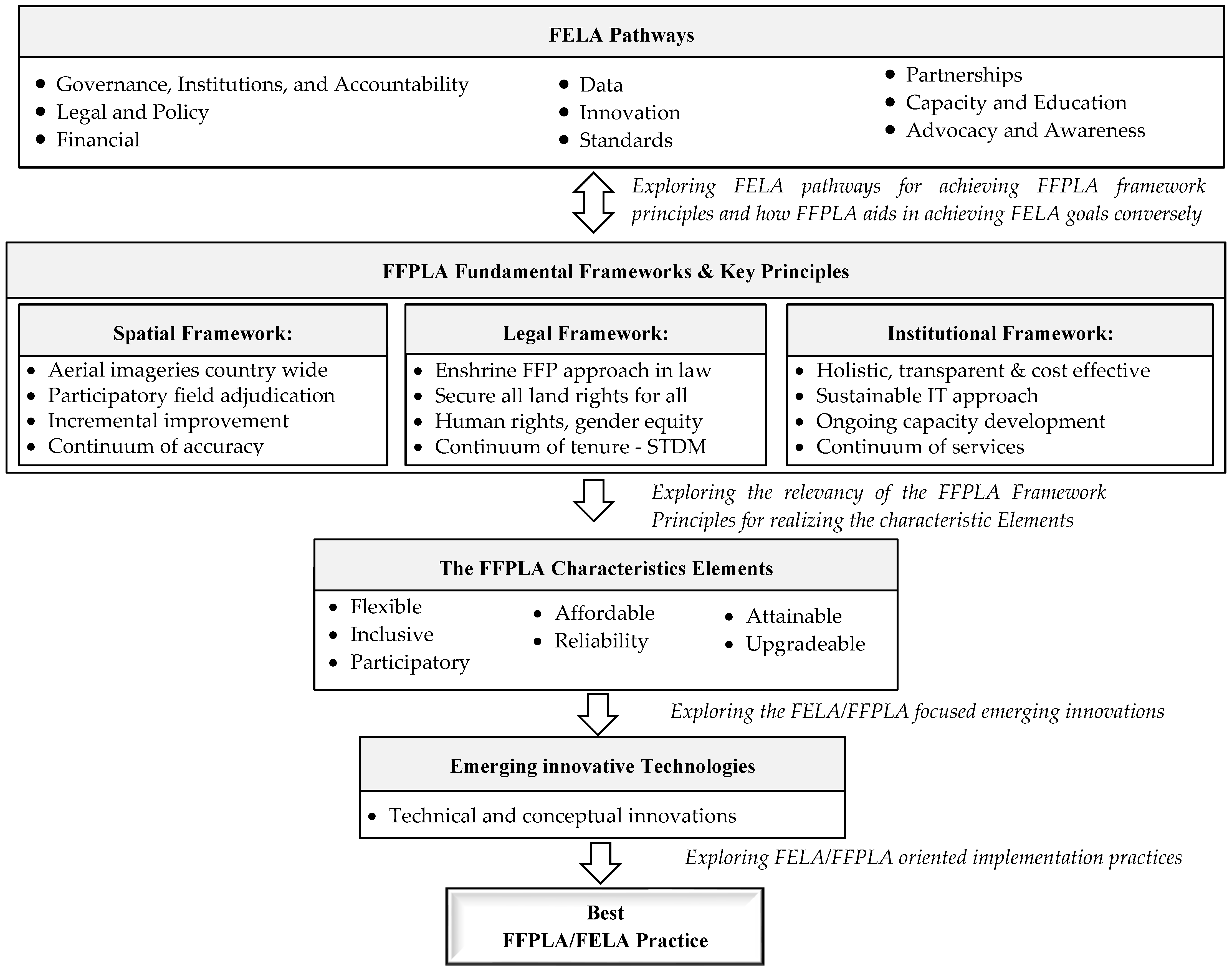
4.2. Addressing of FELA Pathways through FFPLA Implementations

FELA considers emerging global policies and guidelines to ensure the achievement of the continuum of land rights, which FFPLA strives to attain through the fundamental framework principles and implementation strategies [14,41]. Achieving the FFPLA key principles would lead to the realization of the FELA pathway goals and vice versa.
The FELA transparency and accountability pathway is achieved by implementing the FFPLA good land governance, transparent land information, and integrated institutional framework. The goals for being gender-responsive and inclusive of vulnerable groups are realized through the key principles of gender equity for land and property rights. Countries’ flexible ICT and aerial/satellite image implementation could make the system affordable for the government to set up and operate.
Reliable data and service quality are attained through the active participation of the community while identifying and delineating their parcel boundaries over aerial or satellite imagery. Emerging technologies and techniques provide the opportunity to map the rights, restrictions, and responsibilities in different ways, helping achieve the FELA goal of a responsible and innovative system update and upgrade. FFPLA executions adapted the ISO-endorsed LADM and guided partnerships through explicit roles and duties, promoting the attainment of the FELA interoperability and integration standard and partnership goals.
The countries’ background in conventional educational programs, on-the-job training, peer-to-peer learning, and experience sharing, professional dialogue, and seminars would contribute to the FELA. It is necessary to plan and execute advocacy and awareness programs to favor the active participation of the stakeholders and the general public in the land administration tasks and decision-making on land problems.
The countries have mainstreamed different approaches with their legal, spatial, and institutional frameworks while implementing FFPLA. Consequently, the FFPLA-oriented practices helped achieve the FELA pathway goals. Table 5 summarizes the mutual and generalized FFPLA implementation practices expected to address the FELA pathway goals [5].

4.3. Connecting FFPLA Elements, Principles and Frameworks, for Real Results

As seen, the articles reviewed above cover the FFPLA experiences in 15 countries across the globe (Benin, Caribbean Islands2, China, Colombia, Ecuador, Ghana, Indonesia, Kenya, Mozambique, Namibia, Nepal, South Africa, Uganda, Vietnam, and Zambia). The study by Byamugisha [45] is to draw lessons from China and Vietnam pre-FFPLA implementation and identify future upgrading challenges. Some studies explored the holistic application of FFPLA for improving the existing tenure security practices [46,49,50,51,52]. The study cases in Uganda, Nepal, South Africa, Ecuador, and the Caribbean Islands assessed the favorable legal, spatial, and institutional conditions for possible FFPLA implementations. LADM and STDM were also investigated and proved important for cost and time effective FFPLA execution [47,50,51]. The study by Becerra et al. [45] aspired to provide a reliable FFPLA basis for boundary dispute resolution.
According to the purpose and motivation of this study, i.e., to identify the contemporary status and best implementation practices of FFPLA for tenure security, the holistic executions in Benin, Colombia, Ghana, Kenya, Mozambique, Namibia, Nepal, and Uganda are further analyzed based on the FFPLA fundamental framework key principles.
While successfully implementing the key principles under each fundamental framework, the FFPLA-practicing countries would address one or more of the FFPLA characteristics elements. Table 6 summarizes the global implementations of FFPLA key principles and the anticipated elements to be achieved.

4.4. Recognition That Both FELA and FFPLA Innovation Oriented

The review discerned the global effort to implement the FFPLA approach for tenure security, which satisfied the fundamental framework principles, and the FELA pathway goals. The contribution of emerging innovative tools and technologies is remarkable for documenting and securing the pile of unregistered land rights across the globe. Accordingly, significant efforts are being made to back the implementation of practices with innovative geospatial tools and developments. In this context, UN organizations such as the Food and Agriculture Organization (FAO), the Global Land Tool Network (GLTN), and the World Bank (WB) are providing outstanding support for the development and use of innovative tools and technologies for land tenure security [9].
The FFPLA fundamental framework and the FELA pathway goals favor applications of emerging innovations for fast and affordable capturing and maintenance of land information. Various issues also need to be given attention and addressed by utilizing innovative approaches and developments. For example, the conventional surveying field work for parcel boundary identification and collection is time-and resource-intensive [3,59,60]. Maintenance (update/upgrade) of land information systems is not yet regarded as critically important as developing new ones [20]. Even with a fit-for-purpose strategy, finance is one of the vital issues in establishing a land administration system that ensures tenure security [41].
Although there are good practices for cadastral data update, Biraro et al. [61] contend that much work is still required for verified updating procedures, sustained financial and technical capabilities, and identifying concerned institutions. Moreover, cadastral data update/upgrade is becoming a challenging task because of the dynamic nature of people-to-land relationships [20,61]. Bennett et al. [20] reviewed a range of literature concerning land administration maintenance before and after the commencement of FFPLA. The study found that while the previous times’ primary concern was establishing the land administration system, the contemporary era concept and implementation still give less attention to system maintenance (update/upgrade). After a thorough analysis of core maintenance concerns based on the review results, the authors have developed a “Consolidated Analytical Model of Land Administration Maintenance” that illustrates possible ways to maintain the system. They have also proposed using the already available solutions and emerging innovations to core maintenance issues based on the FELA pathways. The model provides a comprehensive outlook on the existing maintenance approaches and future improvement prospects. The authors recommended using the analytical model to detect recurring maintenance issues in a national setting and select the best solution(s) from the available options.
García-Morán et al. [41] pioneered a new public-private partnership (PPP) model to harness the private firms’ capability, expertise, and funding in the land sector. The authors illustrated the approach with the Côte d’Ivoire Land Partnership (CLAP). They investigated the private firms’ active engagement to secure land rights equally for all, as an innovative partnership for FFPLA. Côte d’Ivoire is trying to benefit the land administration from its well-known cocoa crop market through CLAP, a contractual collaboration between the government and a syndicate of private firms. The private sectors take care of the funding for efficient service delivery that targets the land administration demands of the community. The government, on the other hand, is responsible for creating a favorable political atmosphere and operating the land administration functions that benefit the private partners. According to the authors, CLAP is the first of its kind to focus on service delivery and creative process improvement through PPP based on the FFPLA approach. It could serve as a novel reference model to establish PPP that provides more room for private sector active engagement and improved land administration service delivery. The authors demonstrated the significance of the model for developing a PPP framework using the FELA pathways for financing FFPLA. Although the model’s sustainability is not yet fully assessed, the preliminary achievement lies in the political willingness and the long-term commitment of the participant actors. The authors proposed that transferring the model to a similar social, legal, and institutional context could benefit.
These days, free and open-access emerging geospatial technologies are contributing much to solving global tenure security issues. However, implementation of the technologies for FFPLA could be capacity-demanding and challenging. Tan et al. [62] developed a framework to assess the existing land administration conditions for effectively utilizing geospatial technologies according to the FFPLA principles. The framework is a matrix of the seven characteristic elements of the FFPLA approach by six core capacity dimensions (regulations, political system, operational unit, social norms, land recording techniques, and software), identified from semi-structured interviews, literature, and field observations. The framework is employed to identify the present capacity conditions of Rwanda and Kenya for adapting the UAV to the land administration systems. According to the assessment result, weak accessibility of the UAV, a need for strict regulations, and capacity development are identified for Rwanda. Kenya has better access to UAVs but less technical competence for large-scale applications, which might be enhanced through market-led policies, co-production, and outsourcing.
Due to the advancement of computing technologies, various fit-for-purpose, innovative geospatial tools are also being developed and utilized to improve tenure security in developing nations. Compared to the conventional approaches, they are supposed to be faster, cheaper, more flexible, and more responsible for land rights security. Koeva et al. [21] evaluated three geospatial tools (SmartSkeMa, UAVs workflows, and Boundary delineator) and a cloud platform (PaS) against the fit-for-purpose land administration core elements. The tools were developed by the European Commission Horizon 2020 project, “its4land”, to assist sub-Saharan countries’ land rights registration with innovative mapping solutions [63].
Smart SketchMaps (SmartSkeMa) is a combined tool that aligns sketched information with base map data and the existing ortho-images. It is developed to enhance land tenure documentation based on local rules. The UAVs’ workflows are designed to facilitate all the necessary steps for having a high-resolution ortho-image from it. It is a complete set of operational procedures, including flight planning and preparation, data acquisition, processing, and quality assessment. The boundary delineator is an open -source tool that automatically extracts visible parcel boundaries from high-resolution images by UAV, aerial, or satellite platforms and provides possibilities for the users for fast editing and accepting them for further legal approvals. With image analysis and machine learning algorithms behind, it enables faster and cheaper land tenure information collection and minimizes field survey activities. The Publish and Share (PaS) cloud platform works based on the LADM, web-based application programming interface (API), and cloud services platform concepts. It enables land administration system developers to use or incorporate spatial references into land tenure registration and focus only on functionalities request rather than re-implementing solutions for common problems. According to the authors, the tools, and the cloud platform match well with the FFPLA aspects but with a few exceptions, which might be from the research participants’ disparity in conceiving concepts and meanings of the FFPLA elements. They concluded that the tools, independently or combined, could be integrated into land administration workflows by the PaS platform to deliver reliable land information through geo-cloud web service facilities.
Naghavi et al. [64] developed a model for collecting volunteered geographic information (VGI) for tenure security use based on open-source architecture under the Spatial Data Infrastructure (SDI) policy with a primary focus on data accuracy issues. It gathers the land right information via the user-convenient public service interface and media, such as social media, GPS and mobile data, free and open-source applications, etc. Then it transforms the data into standard formats to maximize interoperability and connectivity.
The authors tested the model in Iran and found it promising to collect reliable geographic information with volunteer smartphones that meet the desired data quality. They proposed VGI for time and cost-effective gathering of land information without intensive training. However, it is required to motivate the volunteers for responsible and accurate parcel data collection.
As seen above, both FELA and FFPLA could be enhanced by innovative approaches and technologies. The FELA innovation pathway seeks a responsible and innovative approach to system updating and upgrading. FFPLA also encourages new technological advancements and developments to improve the spatial framework over time. Such emerging technologies are expected to meet the FELA pathways and FFPLA desirable qualities while lowering the investment and operating costs of land administration systems.

4.5. FELA and FFPLA Are Already Working Hand-in-Hand

The study identified the FFPLA fundamental framework key principles implementation practices that satisfy the FELA pathway goals (Table 5) and the characteristic elements (Table 6). A checklist is created based on [9,14] for ease of further comparison to identify the best implementation practices that satisfy the FFPLA fundamental framework key principles, and the FELA pathway goals in common.
Understanding the countries’ responses to FFPLA key principles and FELA pathway goals provides insight into how both work together to build successful cost- and time-effective land administration systems. Table 7 shows the countries response to FFPLA key principles and FELA pathway goals.

5. Discussion

Studies show that significant FFPLA efforts existed, for example, in China, Vietnam, Ethiopia, and Rwanda, before the concept gained global attention [14]. Following the conception of the seven characteristic elements and the three fundamental frameworks, it gained worldwide attention. Nowadays, the practical implementation of FFPLA is rapidly expanding to broader areas of land administration, aiming toward achieving the desirable qualities and the core principles, as outlined in the guiding principles [14].
However, the review focused on the tenure security function of land administration and discussed the execution of the fundamental framework principles of FFPLA, attaining the FFPLA pathway goals (Table 5) and FFPLA characteristic elements (Table 6). This leads to the identification of the best FFPLA execution practices in different geographical and governmental settings across the globe, using a checklist derived from the FELA goals and the FFPLA fundamental framework principles (Table 7). The potential contribution of emerging conceptual and technical innovations for the successful execution of FFPLA is also discussed and proposed promising ones for enhancing the best implementation practices.

5.1. Mainstreamed Practices Addressed Fela Goals through of FFPLA Implementation

The FFPLA approach supports establishing a flexible, inclusive, participatory, affordable, reliable, attainable, and upgradeable land administration system. In one form or the other, these desirable qualities of the FFPLA approach are realized while implementing the key principles of the fundamental framework. Furthermore, fulfilling the FELA pathway goals—as an umbrella framework for effective land administration—would indicate success in achieving the FFPLA approach and its characteristic elements. Although the implementation strategy and purpose differ depending on the ground reality and feasibility, the widespread practices are summarized and discussed under the FELA pathway goals.
  • Goal one: Transparency and accountability exercised
The FELA target for increased transparency and accountability in land administration is relevant to the key principles of the FFPLA institutional framework. Uganda, Nepal, and Benin have implemented institutional coordination with all partners along the chain and clear responsibilities at various levels for transparent land rights registration and service delivery. Nepal further employed the STDM and established an integrated system for instant updates of the local judicial committee decisions on disputes. Mozambique followed a decentralized approach implemented through top-down and bottom-up (national to local, and vice versa) institutional integration with public participation. Appropriate land institutions were participating in the Colombian FFPLA pilot study. Kenya, Ghana, and Namibia engaged in formal and informal (customary and statutory) land sectors. However, the countries failed to avoid bureaucratic procedures for the reliance on chiefs and local authorities (Kenya and Ghana) and statutory requirements (Namibia) for issuing land-holding titles.
  • Goal two: Gender-responsive and inclusive of vulnerable groups enhanced
The FFPLA implementing countries legalized the available forms of tenure and social equity for land rights, which allowed them to achieve gender-responsive and vulnerable-group inclusive land rights. Benin, Ghana, Kenya, Nepal, Namibia, and Uganda registered all tenure types accordingly. Mozambique purposely focused only on customary and good-faith occupation tenure registration. Colombia registered normal rights only, although the approach permits capturing all sorts of people-to-land relationships. Regarding inclusive registration of all social dimensions, Nepal and Uganda recognized the issue of gender and marginalized people having equitable access to land. Colombia, Ghana, Kenya, and Namibia acknowledged equal participation of men and women in land rights registrations. In Benin and Mozambique, women and vulnerable groups were oriented toward their land rights, even claiming their rights without fear of reprisal from their social group.
  • Goal three: Affordable investments and economic returns considered
A hybrid of modern and traditional technologies, simple field survey techniques, and parcel-value-based charges are utilized for affordable investment and expense revenue while registering property rights. The countries also exercised flexible spatial accuracy and on-demand spatial data update/upgrade to minimize the FFPLA approach implementation costs. The prevailing practices also include legalizing the fit-for-purpose data collected by different techniques. Colombia, Ghana, Kenya, Mozambique, Nepal, and Uganda used aerial/satellite imagery to extract general/visible parcel boundaries, a less expensive technique than field surveys and require far less time and capacity. In Nepal and Uganda, simple field survey such as tape measurement, approximations, and smartphone applications are used to measure boundary lines. The approach also allowed for precise field surveys and equipment if a fixed boundary determination is required, with the parties covering the associated costs, as practiced in Benin and Namibia.
  • Goal four: Reliable data and service quality implemented
Participatory and flexible spatial data collection and dispute resolution approaches are applied to meet the FELA goal of reliable data and service quality. Landowners and local land committee members participate in the spatial data collection process in all countries (Benin, Colombia, Ghana, Kenya, Mozambique, Namibia, Nepal, and Uganda), trained and supervised by qualified surveyors. The participants verified the field survey and adjudication results and the registration and certification of land use rights. Nepal further proposed legal amendments to the institutional arrangement to accommodate the process of spatial data acquisition. The FFPLA legal framework proposed a flexible and affordable approach for resolving land disputes and possible conflicts by delegated local administrative institutions (sector and district). Accordingly, Benin, Namibia, Nepal, Ghana, Kenya, and Uganda decentralized the land administration to local levels, thereby enabling the settlement of land disputes and potential confrontations. Mozambique enhanced the traditional judicial procedure for securing land rights and established a system at the provincial level to carry out the registration process.
  • Goal five: Responsible and innovation introduced
Different innovative tools and techniques are employed for parcel data collection, processing, and validation to update/upgrade the system. Mozambique developed less skill-demanding mobile and cloud technologies for participatory identification of the spatial boundaries of land parcels. Uganda collected and stored land rights data using an innovative recordation tool (Sola Open Tenure and CRISP). Nepal used an innovative data model and mapping standards for data collection and system administration at the local level, which could be expanded to the national level. Benin and Namibia used GNSS-integrated smartphones to collect cadastral parcel data. Colombia implemented an advanced positioning service (RTX enabled GNSS) for spatial data collection and the commercial ESRI’s Collector app.
  • Goal six: Interoperability and integration practiced
Internationally agreed standards support interoperability and integration goal of FELA. In this regard, Benin and Mozambique have employed the ISO-endorsed Land LADM to develop the land administration system. Ghana, Kenya, Namibia, and Nepal utilized the STDM for an improved continuum of tenure security.
  • Goal seven: Cooperation, partnerships, and participation encouraged
Few countries achieved this goal through fortifying partnership support and collaboration, engaging partners in organizing and providing awareness and capacity-building activities (Benin), and capacitating land institutions of the local governments (Uganda and Nepal).
  • Goal eight: Capacity, capability, knowledge transfer and exchange attained
The FFPLA approach recommends strategies and activities for capacity development and knowledge transfer as required in the FELA capacity and education pathway. Consequently, Colombia, Mozambique, Uganda, and Nepal carried out awareness and capacity-building programs. Mozambique trained selected community members to capacitate the registration team. Uganda provided training based on an identified gap to enable local land administration assistants. Nepal capacitated grassroots surveyors in mapping with the STDM quickly.
  • Goal nine: National engagement and communication improved
The FELA advocacy and awareness pathway goal targets national engagement and communication. It could be achieved through different advocacy and knowledge-sharing activities, as suggested in the FFPLA approach. Accordingly, Mozambique employed role-play training to educate the community about gender equality principles in land rights. Colombia and Nepal also provided awareness programs to the community to provide reliable and quality datasets. Uganda conducted an extensive public information and communication campaign through accessible media and public meetings.
As seen above, FFPLA-implementing countries have mainstreamed the FFPLA approach into their legal, spatial, and institutional frameworks. The analysis also proves that the FELA overall goals are well incorporated and achieved through the FFPLA implementation principles. The FELA strategic pathways could help countries structure specific strategies for effective land administration, much as the FFPLA guidelines enabled the development of country-specific strategies for FFPLA execution.

5.2. Jointly Pursued FELA Pathways and FFPLA Elements, Principles and Frameworks Provide Best Global Practices

The term “best practice” is used in various disciplines for improving practices based on proven performance [65]. According to the Merriam Webster dictionary [66], best practice is “a procedure that has been shown by research and experience to produce optimal results, and that is established or proposed as a standard suitable for widespread adoption”. For the improved performance of peer projects, best practices provide a guiding framework to implement innovative and replicable experiences of others [67].
The combined success story of the FFPLA key principles and the FELA pathway goals is projected to deliver global best, (or successful) FFPLA implementation practices, as envisaged in the methodology section of the study. As a result, the FFPLA implementation practice in Benin, Colombia, Ghana, Kenya, Mozambique, Namibia, Nepal, and Uganda achieved all or the majority of the FFPLA key principles and the FELA pathway goals. However, the implementation approaches could differ from one country to the other.
In Nepal, FFPLA implementation is satisfactory; the fundamental framework key principles are well implemented, and the FELA pathway goals are achieved. Uganda has likewise successfully implemented FFPLA, but there is little proof of the adopted interoperability and integration standards. The practice in Mozambique satisfied all requirements but was not inclusive in registering all tenure types. It also lacks clearly defined ways for strengthening partnerships and supporting collaboration. Benin did not apply the visible boundary and use of aerial/satellite imagery. In addition, it has no experience in knowledge transfer and awareness-creation for effective land administration. Colombia has met the FELA pathway goals. However, it failed to prove institutional integration for recording and registering land rights by delegated local land authorities. The approach does not prove the absence of bureaucratic barriers. It also employed high-end technology solutions rather than a flexible ICT approach.
Ghana, Kenya, and Namibia have similar stories of meeting the FFPLA key principles and FELA pathway goals. The countries failed to realize good land governance in rural and peri-urban areas, for there is a dependency on local chiefs and authorities (Ghana and Kenya) and extraneous legislative requirements (Namibia) to deliver land-holding titles. Namibia employed a fixed boundary approach, contravening the FFPLA visible boundary key principle. The countries also do not have shared experience in partners’ engagement, advocacy and awareness activities, and capacity-building initiatives.

5.3. Emerging Innovations, Enhancing the Best Practices

Conceptual innovations enhance the successful implementation of FFPLA for a broader range of land administration functions. With the advancement of computing technology and geospatial information demand growth, innovative ideas are emerging and becoming available at the implementation and study level. The innovations are appealing for efficient FFPLA execution to realize tenure security for all, as suggested in the SDGs. However, employing these emerging geospatial technologies in land administration could be capacity-demanding. It would be beneficial to assess in advance the likelihood of successful implementation. A framework developed by Tan et al. [62] could provide insight to examine and identify the available and necessary skills and capacity for implementing the technologies.
Furthermore, while it may need to be aligned with existing ground realities, the innovations are adaptable and applicable to developing countries’ tenure security challenges. The analytical model by Bennett et al. [20] could be employed to identify maintenance issues and propose suitable solutions for the highly dynamic peri-urban land administration update/upgrade issues.
The conceptual development of a new public-private partnership (PPP) could secure the funding for establishing and maintaining the land administration. It would maximize the government’s commitment to fostering a favorable political climate and the private sector’s involvement in land security and enhanced service delivery. The PPP model could involve many private enterprises (real estate companies, agricultural firms, industrial zones, etc.) to financially secure the services rendered by peri-urban land administration for mutual benefit. However, Organizations need to have the appropriate capacity and experience in contract management to successfully design and manage a PPP.
Emerging geospatial tools are providing feasible and extensible solutions as an alternative to the time-and cost-intensive conventional surveying fieldwork for cadastral data collection. The automatic boundary delineator could generate parcel boundaries with acceptable accuracy. SmartSkeMa can be applied for community-based land tenure documentation. The Publish and Share (PaS) cloud platform facilitates land administration system development by offering high-level geocloud-based services. The Volunteered Geographic Information (VGI) model agreed with the FFPLA requirement for engaging the public and private sectors in establishing a geospatial data sharing and publishing platform.

6. Conclusions and Recommendations

The study reviewed 19 articles concerning FFPLA practical implementations and conceptual innovations in 15 countries to identify best practices that could be customized and extended to other land administration settings. Most of the reviewed articles are published in the land journal special issues in 2021 and are concerned about conceptual innovations (Volume I) and practical FFPLA implementations (Volume II) across the globe. Three recent articles from the Land Use Policy Journal are also included. The study employed the FFPLA fundamental framework key principles and FELA pathway goals to characterize the best implementation approach.
According to the study, countries have successfully mainstreamed FFPLA implementation practices into their institutional, legal, and physical frameworks. Even though the FFPLA approach was developed before the FELA Framework, the FFPLA principles and guidelines are well aligned with the FELA goals and pathways. The actual implementation of the FFPLA approach and the FELA goals eventually depend on the country’s context in terms of institutional settings and available capacity. Jointly pursuing FELA and FFPLA could provide best implementation practices that inform approaches for future FFPLA projects. The contribution of emerging geospatial innovations is also promising for efficacious execution of FELA and FFPLA.
From recent FFPLA executions covered in the review, the implementation practice in Nepal is identified as the best practice, for it successfully executed the FFPLA fundamental framework key principles and satisfied the FELA pathway goals. The FFPLA implementations in Uganda, Mozambique, and Benin were also successful and possessed experiences which could be expanded to other countries.
Emerging technical and conceptual innovations are providing promising results, enhancing the cost and time effectiveness of the FFPLA approach. The analytical maintenance model could solve the missing update/upgrade issues in the land administration practices. The public-private partnership (PPP) model is an innovative concept to secure funding for land administration initiatives. The auto-boundary delineator application and the VGI model could be a technical alternative for time and resource consuming surveying fieldwork. SmartSkeMa can be applied for community-based land tenure documentation.
The best FFPLA practices and innovations identified in the study could be customized and extended to other land administration settings, such as peri-urban areas where urbanization is intense. The translation of FELA into Spanish, French, Arabic, Dutch, and Mandarin [18] further helps FFPLA as an implementation tool, get more worldwide recognition. However, Tan et al. [62] suggested a detailed examination of the FFPLA fundamental framework core principles and capacity of the implementing countries for large-scale implementation and technical feasibility. Further research is recommended to evaluate the efficacy, practicability, innovativeness, transferability, and model character of the best practice for spreading it to other land administration contexts, as stated in [67]. A socio-economic impact assessment is also advisable to justify and strengthen the business case for adopting FFPLA. It is a helpful tool to maximize positive benefits that contribute to sustainable development [68].
Nonetheless, it has to be noted that the best FFPLA implementation practice is identified based on the limited information available in the reviewed articles. There could be more studies and implementation practices that do not appear in scientific journals. FFPLA implementation practice and conceptual innovation supported by financial and aid organizations such as the WB, UNHABITAT, GLTN, FAO, etc., could also provide further insights. Project based searches need to be considered for more successful FFPLA innovations and implementation practices. Thus, since the result is formulated based on the journal articles accessed for the study, it does not either judge the various countries’ experiences as insignificant or ignore FFPLA efforts in different situations. Furthermore, following each thriving implementation practice, the willingness and engagement of the governments have to be acknowledged.

Author Contributions

Conceptualization, M.T.M.; methodology, M.T.M., R.M.B., B.K.A. and M.K.; formal analysis, M.T.M.; investigation, M.T.M.; data curation, M.T.M.; writing—original draft preparation, M.T.M.; writing—review and editing, M.T.M., R.M.B., B.K.A. and M.K.; visualization, M.T.M., R.M.B., B.K.A. and M.K. All authors have read and agreed to the published version of the manuscript.

Funding

This research received no external funding.

Institutional Review Board Statement

Not applicable.

Informed Consent Statement

Not applicable.

Data Availability Statement

Not applicable.

Conflicts of Interest

The authors declare no conflict of interest.

Notes

1
PRISMA is an evidence-based minimum set of items for reporting in systematic reviews and meta-analyses (https://prisma-statement.org/; accessed on 9 January 2022).
2
Barbados Jamaica, Saint Lucia, and Trinidad and Tobago are the Caribbean Islands covered in the study.

References

  1. Williamson, I.P. Best practices for land administration systems in developing countries. In Proceedings of the International Conference on Land Policy Reform, Jakarta, Indonesia, 25–27 July 2000; The World Bank: Washington, DC, USA, 2000. [Google Scholar]
  2. Williamson, I.P. Land Administration for Sustainable Development; ESRI Press Academic: Redlands, CA, USA, 2010. [Google Scholar]
  3. Koeva, M.; Stöcker, C.; Crommelinck, S.; Ho, S.; Chipofya, M.; Sahib, J.; Bennett, R.; Zevenbergen, J.; Vosselman, G.; Lemmen, C.; et al. Innovative remote sensing methodologies for Kenyan land tenure mapping. Remote Sens. 2020, 12, 273. [Google Scholar] [CrossRef] [Green Version]
  4. Barry, M. Fit-for-purpose land administration—administration that suits local circumstances or management bumper sticker? Surv. Rev. 2018, 50, 383–385. [Google Scholar] [CrossRef]
  5. de Zeeuw, K.; Benn, T.; Unger, E.-M.; Bennett, R.B. The proposed United Nations framework for effective land administration (FELA): Progress, pathways and prospects. In Proceedings of the Land and Poverty Conference, Washington, DC, USA, 16–20 March 2020. [Google Scholar]
  6. Kasa, L.; Zeleke, G.; Alemu, D.; Hagos, F.; Heinimann, A. Impact of Urbanization of Addis Abeba City on Peri-Urban Environment and Livelihoods; Sekota Dry land Agricultural Research Centre of Amhara Regional Agricultural Research Institute: Addis Ababa, Ethiopia, 2011. [Google Scholar]
  7. Ozlu, M.O.; Alemayehu, A.; Mukim, M.; Lall, S.V.; Kerr, O.T.; Kaganova, O.; Viola, C.O.; Hill, R.; Hamilton, E.; Gapihan, A.T. Ethiopia-Urbanization Review: Urban Institutions for a Middle-Income Ethiopia; The World Bank: Washington, DC, USA, 2015. [Google Scholar]
  8. Adam, A.G. Understanding competing and conflicting interests for peri-urban land in Ethiopia’s era of urbanization. Environ. Urban. 2020, 32, 55–68. [Google Scholar] [CrossRef]
  9. UNGGIM. Framework for Effective Land Administration. Available online: https://ggim.un.org/meetings/GGIM-committee/10th-Session/documents/E-C.20-2020-29-Add_2-Framework-for-EffectiveLand-Administration.pdf (accessed on 25 August 2021).
  10. Enemark, S.; McLaren, R.; Lemmen, C. Fit-for-Purpose Land Administration—Providing Secure Land Rights at Scale. Land 2021, 10, 972. [Google Scholar] [CrossRef]
  11. UN. 2015 Is the Time for Global Action. 2015. Available online: https://www.un.org/sustainabledevelopment/ (accessed on 11 November 2021).
  12. Enemark, S.; Mclaren, R.; Lemmen, C. Fit-for-Purpose Land Administration: Guiding Principles for Country Implementation; GLTN Reference: Copenhagen, Denmark, 2015. [Google Scholar]
  13. Kelm, K.; Antos, S.; McLaren, R. Applying the FFP Approach to Wider Land Management Functions. Land 2021, 10, 723. [Google Scholar] [CrossRef]
  14. Enemark, S.; McLaren, R.; Lemmen, C. Fit-for-Purpose Land Administration Guiding Principles; Global Land Tool Network (GLTN): Copenhagen, Denmark, 2015. [Google Scholar]
  15. Enemark, S.; Bell, K.S.; Lemmen, C.; Mclarem, R. Fit-For-Purpose Land Administration; Joint FIG/World Bank Publication: Copenhagen, Denmark, 2014; Volume FIG. [Google Scholar]
  16. Chigbu, U.E. e-Tracking COVID-19 disruptions to the global development agenda on land. Int. J. Environ. Sci. Nat. Resour. 2020, 26, 556176. [Google Scholar] [CrossRef]
  17. Mitchell, D.; Barth, B.; Ho, S.; Sait, M.; McEvoy, D. The benefits of fit-for-purpose land administration for urban community resilience in a time of climate change and COVID-19 pandemic. Land 2021, 10, 563. [Google Scholar] [CrossRef]
  18. Zeeuw, K.d. Framework for Effective Land Administration (FELA) [PowerPoint Slides]; United Nations Committee of Experts on Global Geospatial Information Management (UN-GGIM): New York, NY, USA, 2022. [Google Scholar]
  19. Bennett, R.; Masli, E.; Potel, J.; Unger, E.M.; Lemmen, C.H.J.; Zeeuw, K.d. Cadastral Entrepreneurs Recognizing the Innovators of Sustainable Land Administration. In Proceedings of the FIG Working Week 2019: Geospatial Information for a Smarter Life and Environmental Resilience, Hanoi, Vietnam, 22–26 April 2019. [Google Scholar]
  20. Bennett, R.M.; Unger, E.-M.; Lemmen, C.; Dijkstra, P. Land Administration Maintenance: A Review of the Persistent Problem and Emerging Fit-for-Purpose Solutions. Land 2021, 10, 509. [Google Scholar] [CrossRef]
  21. Koeva, M.; Humayun, M.; Timm, C.; Stöcker, C.; Crommelinck, S.; Chipofya, M.; Bennett, R.; Zevenbergen, J. Geospatial Tool and Geocloud Platform Innovations: A Fit-for-Purpose Land Administration Assessment. Land 2021, 10, 557. [Google Scholar] [CrossRef]
  22. Kathrine, K. UAVs Revolutionise Land Administration. In GIM International; Geomares: Lemmer, The Netherlands, 2014. [Google Scholar]
  23. Enemark, S. A Fit-For-Purpose approach to Land Administration in Africa in support of the new 2030 Global Agenda, in The Africa We Want. In Proceedings of the 2017 Conference on Land Policy in Africa UN Economic Commisison for Africa, Addis Ababa, Ethipoia, 14–17 November 2017; pp. 1–14. [Google Scholar]
  24. Rahi, S. Research design and methods: A systematic review of research paradigms, sampling issues and instruments development. Int. J. Econ. Manag. Sci. 2017, 6, 2. [Google Scholar] [CrossRef]
  25. Burns, M.; Bally, J.; Burles, M.; Holtslander, L.; Peacock, S. Constructivist Grounded Theory or Interpretive Phenomenology? Methodological Choices Within Specific Study Contexts. Int. J. Qual. Methods 2022, 21, 16094069221077758. [Google Scholar] [CrossRef]
  26. Snyder, H. Literature review as a research methodology: An overview and guidelines. J. Bus. Res. 2019, 104, 333–339. [Google Scholar] [CrossRef]
  27. Petticrew, M.; Roberts, H. Systematic Reviews in the Social Sciences: A Practical Guide; Blackwell Publishing: Malden, MA, USA, 2006. [Google Scholar]
  28. Pham, T.-T.-H.; Turner, S.; Trincsi, K. Applying a Systematic Review to Land Use Land Cover Change in Northern Upland Vietnam: The Missing Case of the Borderlands. Geogr. Res. 2015, 53, 419–435. [Google Scholar] [CrossRef]
  29. Ali, Z.; Zevenbergen, J.; Tuladhar, A. Assessing the Quality Land Administration System in Pakistan Using Systematic Approach of Case Study Methodology. Am. J. Rural Dev. 2014, 2, 40–45. [Google Scholar] [CrossRef] [Green Version]
  30. Križanović, J.; Pivac, D.; Tomić, H.; Mastelić-Ivić, S. Review of Land Administration Data Dissemination Practices: Case Study on Four Different Land Administration System Types. Land 2021, 10, 1175. [Google Scholar] [CrossRef]
  31. Deininger, K.; Ali, D.A.; Holden, S.; Zevenbergen, J. Rural land certification in Ethiopia: Process, initial impact, and implications for other African countries. World Dev. 2008, 36, 1786–1812. [Google Scholar] [CrossRef] [Green Version]
  32. Bennett, R.M.; Alemie, B.K. Fit-for-purpose land administration: Lessons from urban and rural Ethiopia. Surv. Rev. 2016, 48, 11–20. [Google Scholar] [CrossRef] [Green Version]
  33. Bizoza, A.R.; Opio-Omoding, J. Assessing the impacts of land tenure regularization: Evidence from Rwanda and Ethiopia. Land Use Policy 2021, 100, 104904. [Google Scholar] [CrossRef]
  34. Whetsel, H.B. Guidelines for Reviewers and the Editor at the Nuclear Safety Information Center. (No. ORNL-NSIC-47); Oak Ridge National Lab (ORNL): Oak Ridge, TN, USA, 1970. [Google Scholar]
  35. Kitsakis, D.; Paasch, J.M.; Paulsson, J.; Navratil, G.; Vučić, N.; Karabin, M.; Tenório, C.A.F.; El-Mekawy, M. 3D real property legal concepts and cadastre: A comparative study of selected countries to propose a way forward. In Proceedings of the 5th International FIG Workshop on 3D Cadastres, Athens, Greece, 18–20 October 2016; International Federation of Surveyors: Copenhagen, Denmark, 2016. [Google Scholar]
  36. Augustinus, C. Comparative Analysis of Land Administration Systems: African Review with Special Reference to Mozambique; Uganda, Namibia, Ghana and South Africa; The World Bank: Washington, DC, USA, 2003. [Google Scholar]
  37. Brits, A.-M.; Grant, C.; Burns, T. Comparative study of land administration systems. In Proceedings of the Regional Workshops on Land Policy Issues-Asia Program, Phnom Penh, Cambodia, 4–6 June 2002. [Google Scholar]
  38. Katz, E.G. Social capital and natural capital: A comparative analysis of land tenure and natural resource management in Guatemala. Land Econ. 2000, 76, 114–132. [Google Scholar] [CrossRef]
  39. Zevenbergen, J. The interrelated influence of the technical, legal and organisational aspects on the functioning of land registrations (cadastres). In Proceedings of the XXI FIG Congress, Commission, Brighton, 19–25 July 1998. [Google Scholar]
  40. Molen, P.v.d.; Silayo, E.H.; Tuladhar, A.M. A Comparative Study to Land Policy in 9 Countries in Africa and Asia. In Proceedings of the FIG Working Week 2008: Integrating Generations and FIG/UN-HABITAT Seminar: Improving Slum Conditions through Innovative Financing, Stockholm, Sweden, 14–19 June 2008; pp. 14–19. [Google Scholar]
  41. García-Morán, A.; Ulvund, S.; Unger, E.-M.; Bennett, R.M. Exploring PPPs in Support of Fit-for-Purpose Land Administration: A Case Study from Côte d’Ivoire. Land 2021, 10, 892. [Google Scholar] [CrossRef]
  42. Musinguzi, M.; Enemark, S.; Mwesigye, S. Fit for Purpose Land Administration: Country Implementation Strategy for Addressing Uganda’s Land Tenure Security Problems. Land 2021, 10, 629. [Google Scholar] [CrossRef]
  43. Koeva, M.; Bennett, R.; Gerke, M.; Crommelinck, S.; Stöcker, C.; Crompvoets, J.; Ho, S.; Schwering, A.; Chipofya, M.; Schultz, C.; et al. Towards Innovative Geospatial Tools for Fit-For-Purpose Land Rights Mapping. Int. Arch. Photogramm. Remote Sens. Spat. Inf. Sci. 2017, 42, 37–43. [Google Scholar] [CrossRef] [Green Version]
  44. World Bank. Opportunity Assessment to Strengthen Collective Land Tenure Rights in FCPF Countries; The World Bank: Washington, DC, USA, 2021. [Google Scholar]
  45. Byamugisha, F.F.K. Experiences and development impacts of securing land rights at scale in developing countries: Case studies of China and Vietnam. Land 2021, 10, 176. [Google Scholar] [CrossRef]
  46. Balas, M.; Carrilho, J.; Lemmen, C. The Fit for Purpose Land Administration Approach-Connecting People, Processes and Technology in Mozambique. Land 2021, 10, 818. [Google Scholar] [CrossRef]
  47. Antonio, D.; Njogu, S.; Nyamweru, H.; Gitau, J. Transforming Land Administration Practices through the Application of Fit-For-Purpose Technologies: Country Case Studies in Africa. Land 2021, 10, 538. [Google Scholar] [CrossRef]
  48. Panday, U.S.; Chhatkuli, R.R.; Joshi, J.R.; Deuja, J.; Antonio, D.; Enemark, S. Securing Land Rights for All through Fit-for-Purpose Land Administration Approach: The Case of Nepal. Land 2021, 10, 744. [Google Scholar] [CrossRef]
  49. Becerra, L.; Molendijk, M.; Porras, N.; Spijkers, P.; Reydon, B.; Morales, J. Fit-for-purpose applications in Colombia: Defining land boundary conflicts between Indigenous Sikuani and neighbouring settler farmers. Land 2021, 10, 382. [Google Scholar] [CrossRef]
  50. Morales, J.; Lemmen, C.; de By, R.A.; Dávila, A.E.O.; Molendijk, M. Designing all-inclusive land administration systems: A case study from Colombia. Land Use Policy 2021, 109, 105617. [Google Scholar] [CrossRef]
  51. Mekking, S.; Kougblenou, D.; Kossou, F. Fit-For-Purpose Upscaling Land Administration—A Case Study from Benin. Land 2021, 10, 440. [Google Scholar] [CrossRef]
  52. Chigbu, U.E.; Bendzko, T.; Mabakeng, M.; Kuusaana, E.; Tutu, D. Fit-for-Purpose Land Administration from Theory to Practice: Three Demonstrative Case Studies of Local Land Administration Initiatives in Africa. Land 2021, 10, 476. [Google Scholar] [CrossRef]
  53. Martono, D.B.; Aditya, T.; Subaryonoand, S.; Nugroho, P. The Legal Element of Fixing the Boundary for Indonesian Complete Cadastre. Land 2021, 10, 49. [Google Scholar] [CrossRef]
  54. Griffith-Charles, C. Application of FFPLA to achieve economically beneficial outcomes post disaster in the Caribbean. Land 2021, 10, 475. [Google Scholar] [CrossRef]
  55. Todorovski, D.; Salazar, R.; Jacome, G. Assessment of Land Administration in Ecuador Based on the Fit-for-Purpose Approach. Land 2021, 10, 862. [Google Scholar] [CrossRef]
  56. Williams-Wynn, C. Applying the Fit-for-Purpose Land Administration Concept to South Africa. Land 2021, 10, 602. [Google Scholar] [CrossRef]
  57. Oosterom, P.v.; Lemmen, C. The land administration domain model (LADM): Motivation, standardisation, application and further development. Land Use Policy 2015, 49, 527–534. [Google Scholar] [CrossRef]
  58. Uitermark, H.T.; Oosterom, P.J.M.V.; Zevenbergen, J.A.; Lemmen, C.H.J. From LADM/STDM to a spatially enabled society: A vision for 2025. In Proceedings of the Land Governance-Moving towards Land Information 2025: Next Steps-Annual Bank Conference on Land Policy and Administration, Washington, DC, USA, 26–27 April 2010; The World Bank: Washington, DC, USA, 2010. [Google Scholar]
  59. Enemark, S.; McLaren, R. Fit-for-purpose land administration: Developing country specific strategies for Implementation. In Proceedings of the 2017 World Bank Conference on Land and Poverty, Washington, DC, USA, 20–24 March 2017; World Bank Publications: Washington, DC, USA, 2017. [Google Scholar]
  60. Yildiz, O.; Erden, C. Cadastral updating: The case of Turkey. Surv. Rev. 2020, 53, 335–348. [Google Scholar] [CrossRef]
  61. Biraro, M.; Zevenbergen, J.; Alemie, B.K. Good Practices in Updating Land Information Systems That Used Unconventional Approaches in Systematic Land Registration. Land 2021, 10, 437. [Google Scholar] [CrossRef]
  62. Tan, E.; Pattyn, V.; Flores, C.C.; Crompvoets, J. A capacity assessment framework for the fit-for-purpose land administration systems: The use of unmanned aerial vehicle (UAV) in Rwanda and Kenya. Land Use Policy 2021, 102, 105244. [Google Scholar] [CrossRef]
  63. Its4land. We’ve Created Six New Tools to Make Land Rights Mapping Faster, Cheaper, Easier, and More Responsible. 2016. Available online: https://its4land.com/ (accessed on 30 March 2022).
  64. Naghavi, M.; Alesheikh, A.A.; Hakimpour, F.; Vahidnia, M.H.; Vafaeinejad, A. VGI-based spatial data infrastructure for land administration. Land Use Policy 2022, 114, 105969. [Google Scholar] [CrossRef]
  65. Druery, J.; McCormack, N.; Murphy, S. Are best practices really best? A review of the best practices literature in library and information studies. Evid. Based Libr. Inf. Pract. 2013, 8, 110–128. [Google Scholar] [CrossRef]
  66. Merriam-Webster. Best Practice. Available online: https://www.merriam-webster.com/dictionary/best%20practice (accessed on 12 April 2022).
  67. Losada, A.M.I.; Nucci, M.R.D.; Krug, M. Methodological Framework for Good/Best Practices Selection. COME RES Project. 2021. Available online: www.come-res.eu (accessed on 10 June 2022).
  68. Vis, M.; Dörnbrack, A.-S.; Haye, S. Socio-Economic Impact Assessment Tools. In Socio-Economic Impacts of Bioenergy Production; Springer: Berlin, Germany, 2014; pp. 1–16. [Google Scholar]
Figure 1. FFPLA fundamental frameworks [14].
Land 12 00058 g001
Figure 2. Literature identification flow-diagram.
Land 12 00058 g002
Figure 3. The research methodology.
Land 12 00058 g003
Table 1. FELA: Goals, Requirements, and Pathways [9]. From Framework for Effective Land Administration, by UNGGIM. ©United Nations 2022. Reprinted with the permission of the United Nations.
FELA GoalsFELA RequirementFELA Pathway
Transparency and accountability
increased
Accountable and transparent
Governance
Governance, Institutions and
Accountability
Gender-responsive and inclusive
of vulnerable groups
Inclusive and recognize all forms of
Tenure
Policy and Legal
Affordable investments and
economic returns assured
Affordable with sustainable
business models
Financial
Reliable data and service quality
attained
Data maintained, secure and not
duplicated
Data
Responsible and innovation
oriented
Upgradable systems and approachesInnovation
Interoperability and integration
supported
Considers internationally agreed
Standards
Standards
Cooperation, partnerships, and
participation leveraged
Strengthens partnerships and
supports collaboration
Partnerships
Capacity, capability, knowledge transfer and exchange attainedFacilitates capacity development
and knowledge transfer
Capacity and Education
National engagement and communication enhancedAdvocates for land administration
and management
Advocacy and Awareness
Table 2. Elements of the FFPLA approach [15].
FFP ElementPurpose
Flexiblein the spatial data capture approaches to provide for varying use and occupation.
Inclusivein scope to cover all tenure and all land
Participatoryin approach to data capture and use to ensure community support.
Affordablefor the government to establish and operate, and for society to use.
Reliabilityin terms of information that is authoritative and up-to-date
Attainableto establish the system within a short timeframe and within available resources.
Upgradeablewith regard to incremental improvement over time in response to social and legal needs and emerging economic opportunities.
Table 3. FFPLA alignment with the FELA pathway goals adapted from [9,14].
FELA PathwayFELA GoalFFPLA Alignment
Governance,
Institutions, and
Accountability
Transparency and accountability increasedGood land governance rather than bureaucratic barriers
Integrated institutional framework rather than sectorial silos
Transparent land information with easy and affordable access for all
Policy and LegalGender-responsive and inclusive of vulnerable groupsEnsuring gender equity for land and property rights
A continuum of tenure rights rather than just individual ownership
FinancialAffordable investments and economic returns assuredFlexible ICT approach rather than high-end technology solutions
Aerial/satellite imagery rather than field surveys
Sustainable business model that secures land administration institutions’ financial constraints
DataReliable data and service quality attainedVisible boundaries rather than fixed boundaries
Accuracy relates to the purpose rather than technical standards
Spatial framework that provides reliable and up to date data
InnovationResponsible and innovation orientedAdopts procedures for updating/upgrading and ongoing improvement of the spatial framework
StandardsInteroperability and integration supportedAdopts LADMSTDM
Other international ICT interoperable standards.
PartnershipsCooperation, partnerships, and participation leveragedSupports Public Private Partnerships and collaboration to be leveraged in the land sector
Capacity and EducationCapacity, capability, and knowledge transfer attainedFacilitates capacity development and knowledge transfer through adequate measures of education and training
Advocacy and AwarenessNational engagement and communication enhanced for effective land administrationPromotes advocacy, awareness creation, and knowledge sharing and dissemination for effective land administration
Table 4. Summary of FFPLA implementation practices and studies.
Purpose of ImplementationFFPLA Application ContextCountryAuthor(s)
Improving the existing tenure security practicesConnecting people, processes, and technology to improve the existing land administration practice MozambiqueBalas et al. [46].
Using FFPLA as a guideline to improve tenure security in peri-urban, urban, and rural land administration settingsKenya, Ghana, NamibiaChigbu et al. [52]
Applying the FFPLA “general-boundary” approach to enhance systematic registrationIndonesiaMartono et al. [53]
Enhancing boundary dispute resolutions by the FFPLA approachColombiaBecerra et al. [49]
Assessing suitability of the spatial, legal, and
institutional frameworks
Identifying spatial, legal, and institutional framework gaps for FFPLA implementationUgandaMusinguzi et al. [42]
Evaluating the FFPLA approach for identification, verification, and recordation (IVR) of informal land rightsNepalPanday et al. [48]
Assessing the current land administration experience for adopting the FFPLA approach in future development. CaribbeanGriffith-Charles [54]
Assessing the alignment of the FFPLA framework principles with the existing spatial, legal, and institutional frameworks EcuadorTodorovski et al. [55]
Investigating the feasibility of the existing LA system to adapt FFPLA South AfricaWilliams-Wynn [56]
LADM and STDM,
enhancing FFPLA implementation
Employing the STDM to enhance the FFPLA approachUganda, Kenya, and ZambiaAntonio et al. [47]
Applying LADM to improve and speed up the conventional land administration approachBeninMekking et al. [51]
Applying LADM for a participatory cadastral data collectionColombiaMorales et al. [50]
Table 5. Anticipated FFPLA implementation practices to address the FELA pathway goals.
FELA
Pathway
FELA
Requirement
Countries’ FFPLA Practice
/Based on the Review/
Case Example Country
Governance,
Institutions and Accountability
Accountable and transparent
governance
-
Institutional integration with clear responsibilities
-
Transparent and participatory conflict resolution
-
Transparent and accessible land administration
-
Integrated and harmonized stakeholders participation
-
Flexible and good governance workflows
-
Unified registration system for data integrity, quality, and sharing
Benin, Colombia, Mozambique,
Namibia, Nepal, Ghana, Kenya, Uganda
Policy and LegalInclusive and recognize all forms of tenure
-
Legal recognitions of available forms of tenure system
-
Legally recognize social equity to land and property rights
-
Public awareness for conscious participation in property and land right registration
Benin, Colombia, Mozambique, Namibia, Nepal, Ghana, Kenya, Uganda
FinancialAffordable with sustainable business models
-
Participatory data collection with affordable technologies
-
Simple field surveys for non-visible boundaries
-
Set of guidelines and standards for inexpensive right registration
-
Parcel value-based charge for expense revenue.
Benin, Colombia, Mozambique, Namibia, Nepal, Ghana, Kenya, Uganda
DataData maintained, secure and not duplicated
-
A hybrid of modern and traditional technologies and techniques for spatial data collection
-
Clear and participatory procedure for reliable spatial framework
-
Accuracy corresponds to the purpose or reality
-
Legal recognition for fit-for-purpose parcel data
-
Ground survey technique for small areas
Benin, Colombia, Mozambique, Namibia, Nepal, Ghana, Kenya, Uganda
InnovationUpgradable systems and approaches
-
Innovative tools and techniques for flexible and participatory parcel data collection and storing
-
Organizational process and incentives for innovative data model and mapping standards
Benin, Colombia, Mozambique, Nepal, Uganda
StandardsConsiders
internationally agreed standards
-
Adopt LADM
-
Employ STDM
-
Developed desired standards for archives, and digital records
Mozambique, Benin, Nepal, Kenya,
Ghana, Namibia,
Uganda, Colombia
PartnershipsStrengthens partnerships and supports
collaboration
-
Fortify partnership support and collaboration in organizing and providing awareness and capacity building activities
-
Encourage partners’ technical and financial support to capacitating local governments land institutions
Benin, Colombia, Nepal, Uganda
Capacity and EducationFacilitates capacity development and knowledge transfer
-
Capacity building training for grassroots surveyors, local land administration assistants, community members
-
Skill gap-based training packages and capacity building program
Colombia,
Mozambique, Nepal, Uganda,
Advocacy and AwarenessAdvocates for land administration and management
-
Role-play training to aware the community
-
Community awareness for providing reliable and quality datasets
-
Political awareness and government engagement for securing land rights at scale.
Colombia,
Mozambique,
Nepal, Uganda,
Table 6. Global implementations of FFPLA key principles and the expected elements to achieve.
FFPLA Core FrameworkFFPLA Key Principle FFPLA Element to Achieve Case Example
Country
SpatialVisible (physical) boundaries rather than fixed boundariesFlexible: in the spatial data capture approaches (general boundaries, simple field surveys, fixed boundaries)
Affordable: visible boundary approach and simple survey techniques are less time and capacity demanding.
Colombia,
Mozambique, Nepal, Ghana, Kenya,
Uganda
Aerial/satellite imagery rather than field surveysAffordable: for it is cheaper than field surveys and much less time and capacity demanding.
Participatory: in approach to data capture and use to ensure community support.
Reliable: in terms of information that is authoritative and up-to-date for disputes are solved in the field at the presence of the claimants
Colombia,
Mozambique,
Namibia, Nepal,
Ghana, Kenya, Uganda
Accuracy relates to the purpose rather than technical standardsFlexible: in the spatial data capture approach (mapping scale and technology) to provide for varying use and occupation.
Affordable: for it does not employ highly accurate and precise technical standards and technologies to achieve these
Benin, Colombia, Mozambique,
Namibia, Nepal, Ghana, Kenya, Uganda
Demands for updating and opportunities for upgrading and ongoing improvementUpgradeable: with regard to incremental improvement over time in response to social and legal needs and emerging economic opportunitiesBenin, Colombia, Mozambique, Namibia, Nepal, Ghana, Kenya, Uganda
LegalA flexible framework designed along administrative rather than judicial lines.Flexible: in recording and registering land rights by administrative institutions under delegated authority, rather than being dependent on judicial lines.
Affordable: for securing land rights are believed to be time and resource consuming both for the courts and the land right claimant.
Benin, Mozambique, Namibia, Nepal, Ghana, Kenya, Uganda
A continuum of tenure rather than just individual ownershipInclusive: in scope to cover all tenure and all land
Reliable: for it registers all tenure without owners’ discrimination.
Benin, Colombia, Namibia, Nepal, Ghana, Kenya, Uganda
Flexible recordation rather than only one registerFlexible: in national as well as local recordation of the various tenure types
Participatory: to integrate local categorization of land rights
Affordable: for the citizens particularly the poor to enable and the country to scale up the system.
Benin, Mozambique, Namibia, Nepal, Ghana, Kenya, Uganda
Ensuring gender equity for land and property rights.Inclusive: in securing landholding rights and tenure security to all social dimension
Reliable: for it ensures tenure security irrespective of gender or social dignity.
Benin, Colombia, Mozambique, Namibia, Nepal, Ghana, Kenya, Uganda
InstitutionalGood land governance rather than bureaucratic barriersReliable: in the service and the information it delivers.
Benin, Mozambique, Nepal, Uganda
Integrated institutional framework rather than sectorial silosFlexible: in handling local land right and tenure security issues to deliver customer oriented and accessible service
Affordable: for local service access due to the institutional integration
Benin, Colombia, Mozambique, Namibia, Nepal, Ghana, Kenya, Uganda
Flexible ICT approach rather than high-end technology solutionsFlexible: to begin with attainable ICT solutions, employing Free and Open-Source Software (FOSS), flexible to accommodate changes,
Attainable: to establish the system within a short timeframe and within available resources.
Upgradable: to new ICT technology and platforms over time.
Benin, Mozambique, Namibia, Nepal, Ghana, Kenya, Uganda
Transparent land information with easy and affordable access for allReliable: in terms of information that is authoritative and up-to-date
Affordable: for it provides easy and inexpensive access for all
Benin, Colombia, Mozambique,
Namibia, Nepal, Ghana, Kenya, Uganda
Table 7. FFPLA and FELA implementation checklist based on [9,14].
FFPLA
Core Framework/
FELA Pathway
FFPLA Key Principle/
FELA Pathway Goals
FFPLA Implementing Countries
BeninColombia GhanaKenyaMozambiqueNamibiaNepalUganda
SpatialVisible (physical) boundaries rather than fixed boundaries
Aerial/satellite imagery rather than field surveys
Accuracy relates to the purpose rather than technical standards
Demands for updating/upgrading and ongoing improvement
LegalA flexible framework designed along administrative lines.
A continuum of tenure rather than just individual ownership
Flexible recordation rather than only one register
Ensuring gender equity for land and property rights.
InstitutionalGood land governance rather than bureaucratic barriers
Integrated institutional framework rather than sectorial silos
Flexible ICT approach rather than high-end technology solutions
Transparent land information with easy and affordable access for all
Governance,
Institutions, and
Accountability
Accountability and transparency increased
Policy and LegalGender-responsive and inclusive of vulnerable groups
FinancialAffordable investments and economic returns assured
DataReliable data and service quality attained
InnovationResponsible and innovation oriented
StandardsInteroperability and integration supported
PartnershipsCooperation, partnerships, and participation leveraged
Capacity and
Education
Capacity, capability, knowledge transfer and exchange attained
Advocacy and
Awareness
National engagement and communication enhanced for
effective land administration
Disclaimer/Publisher’s Note: The statements, opinions and data contained in all publications are solely those of the individual author(s) and contributor(s) and not of MDPI and/or the editor(s). MDPI and/or the editor(s) disclaim responsibility for any injury to people or property resulting from any ideas, methods, instructions or products referred to in the content.

