Article

Long-Term Visioning for Landscape-Based Spatial Planning—Experiences from Two Regional Cases in The Netherlands

1
Department Wageningen Environmental Research, Wageningen University & Research, P.O. Box 47, 6700 AA Wageningen, The Netherlands
2
Land Use Planning Group, Wageningen University & Research, Wageningen University, P.O. Box 47, 6700 AA Wageningen, The Netherlands
*
Author to whom correspondence should be addressed.
Land 2023, 12(1), 38; https://doi.org/10.3390/land12010038
Submission received: 18 November 2022 / Revised: 20 December 2022 / Accepted: 21 December 2022 / Published: 23 December 2022
(This article belongs to the Special Issue Landscape-Based Spatial Planning in Europe)

Abstract

:
Normative scenarios for long-term (e.g., 100 years) landscape development can be very inspiring to imagine outside the box landscape futures, without being obliged to define concrete policy objectives for the shorter term. However, it remains challenging to translate such long-term visions into clear transition pathways. We draw upon a landscape-based design approach to local spatial planning to foster a transition to a well-functioning landscape, resilient to various external pressures. Inspired by a national visioning exercise for the Netherlands in 2120, two local case studies at municipal level in the Netherlands are analysed, aiming to identify in what ways the setup of a regional landscape-based design study using future visions can optimise the spatial planning process. Therefore, this comparative case study analysed the cases on the landscape-based approach, the design process, and the future visions formulated. The comparison shows that fostering abiotic differences safeguards sustainable and resilient landscapes; moreover, co-creation relying on representative local actors appears fundamental for shared solutions, while a landscape-based approach guarantees transitions to adaptive and biodiverse landscapes. We conclude that a shared long-term future landscape vision is a crucial source of inspiration to solve today’s spatial planning problems. The constellation of the stakeholder group involved and the methodological setup of a visioning process are determinative for the way a long-term vision is suited to informing spatial planning for a sustainable future.

1. Introduction

Today’s society faces major challenges in the sustainable management of rural and urban landscapes. Climate change, the energy transition, changing demography, decreasing biodiversity, and soil degradation are topical issues to achieve a sustainable and just future [1,2]. National governments, as well as international bodies, such as the European Union, have shown a growing awareness of these problems, calling for solid and shared normative visions of the future of our landscape [3,4].
The Netherlands is a low-lying delta region, experiencing local and regional climate change effects, especially in terms of excess and deficient water provision [5,6]. While mobility and land ownership rights have guided much of the spatial planning in the Netherlands in the past 70 years, currently, geographical characteristics such as geology, soil, and hydrology are increasingly considered as better guiding principles to prevent later adaptation challenges. For example, the Governmental Commissary on Climate Adaptation recently advised the government that “the water and soil system should be leading in the spatial planning of the Netherlands to be more in tune with the characteristics and natural dynamics of our delta” [7], and the Minister of Housing and Spatial Planning decided that “the water and soil system be included as a guiding principle” in solving the urgent challenges of housing development in the Netherlands [8]. The much-debated comprehensive Environment and Planning Act of the Netherlands that will come into force in January 2023, emphasises in many respects the integrated character of spatial planning [9]. Moreover, the EU Green Deal sets out an integrated strategy for tackling climate and environment-related challenges, including sustainable soil management [10]. Planning approaches that take the natural characteristics of the landscape as a guiding principle have the potential to guide landscape developments in a sustainable direction, utilizing local opportunities that result from soil and groundwater patterns and processes and respecting the carrying capacity of the natural system. For such planning approaches to address today’s environmental challenges in an integrated manner, a long-term vision of what our future landscape could look like can form a crucial source of inspiration and common ground to overcome sectoral interests [11].
Within this context, one of the starting points for this paper is a future vision of the spatial configuration of the Netherlands in 100 years’ time, in response to climate change: the NL2120 study [12]. The vision, i.e., a desirable future state [13,14], outlined a perspective for the Netherlands in the year 2120. The NL2120 study offered a narrative in which this densely populated country gave priority to nature, a sustainable economy, quality of life, and safety. This story centred on the ecosystem of the Netherlands as a whole, in which solutions for climate and biodiversity went hand in hand, adapting to extreme situations and growing uncertainties. Five basic principles were adopted in the design:
  • The natural system as the starting point;
  • Optimal use of water;
  • Nature-inclusive society;
  • Circular economy;
  • Adaptive spatial planning.
Not by chance, the natural carrying capacity of the country, defined by the basic physiographic processes of the country, was positioned centrally in the future vision. Because these processes were different across the country, many different approaches are being developed to elaborate the future. Although this leads to associated incompatibilities of approaches and implementation in adjacent regions, the diversity in approaches and ideas of the future was one of the main benefits aimed for by the authors. The diversity of ideas and approaches was illustrated in maps and visuals, which enhanced the discursive power of the message [11]. Figure 1 gives the examples of two landscapes, in which the vision for the future was based on following assessment by a panel of experts [12], taking account of the unique characteristics of the various regions in a landscape-based approach (i.e., an approach to spatial planning that makes use of the opportunities offered by the landscape, further differentiated by societal expectations and cultural norms [15], p. 3). For both of the two landscapes the current situation is depicted, and an imagination of the situation in 2120. For the Riverine areas, this implies, for example, a substantial widening of the river floodplain, strengthening of the flood levees, and a transition to circular agriculture on the farmland. For the Coastal areas, more differentiation in the coastal gradient and expansion of nature areas is envisaged.

2. Theory and Reference to Recent Insights

2.1. The Design Process of Visioning to Support Sound Spatial Transitions

To achieve a sound transition towards a sustainable and climate-proof society, adequate strategies need be developed at regional levels, aligning the actions of different sectors and actors [16,17]. The expertise from various disciplinary backgrounds and practitioners needs to be integrated to come to systemic sustainable solutions [18]. Creating a representation of a desirable future state, i.e., a vision, is considered a key method in transformational sustainability research as a stimulus for change and a point of reference to develop strategies [13]. Recent examples of visions that aim to inform sustainability pathways include, among others, visions of circular and climate-neutral households of the future [19], visions for nature in cities [20], and visions that depict desirable futures of a national park [21].
One means to craft visions that can guide us towards sustainable futures is design. Designing encompasses the development of alternative proposals for the envisioned future spatial organisation of the environment and its aesthetic appearance, which subsequently are evaluated and refined to determine the preferred solution, i.e., “the design” [22,23]. Designing is, in essence, an integrative activity [24]; accordingly, it can contribute by exploring diverging issues at hand and developing coherent solutions. At the same time, designing can provide process-related contributions and support, for example, consensus building [22]. Indeed, Regional Design has recently been presented as a powerful means to realise systemic and stakeholder-driven transitions [25].
Realising and envisioning a future landscape and society calls for fundamental transformation [26]. Transition theory presents an answer to this call [27]: once a real transition is required, a regime shift should be sought for, in the sense of positive futures. Indeed, recent visioning research suggests that positive visioning and inspirational visions are key to generating pathways for transformation towards sustainability [28]. In a landscape context, the transition should be based on the landscape as a vehicle for change.

2.2. Landscape-Based Approach

Although visioning has been used more frequently as a method for strategic (urban) planning, including nature-based planning for urban areas [20,29,30], this study is innovative in drawing upon a landscape-based design approach. Designing a future vision for a region using a landscape-based approach as the underlying principle can offer a common ground to practitioners and scientists of differing backgrounds, values, and interests [31,32]. To integrate the knowledge from experts with different disciplinary backgrounds, these experts need to be well trained in their own discipline but also capable of looking and communicating beyond disciplinary boundaries. Landscape is an integrative concept that is the common working domain of various ecological, economic, sociocultural, and political disciplines [32]. Hence, “landscape” can serve as a boundary concept [15]. Following Westerink [22], a boundary concept is flexible enough to adapt to local needs and to different perspectives but also robust enough to maintain conceptual coherence across scientific disciplines and across the science–practice boundary [33,34].
The development of this boundary concept started with soil science. After the second world war, a rapid development of soil mapping occurred in northwestern European countries, mainly to support national policies to ensure proper food supplies in the future. Soil maps were used for land classification and became a basis for land consolidation policies based on the emerging science of land evaluation, which enabled policymakers to connect potential agricultural production with existing soil characteristics [35]. Later, soil science also became the basis of nature conservation and renaturation plans [36]. The domination of engineering practices made the consideration of soil and subsoil characteristics redundant in post-war large-scale urban development plans. Still, a review of European capitals and their relation to the landscape, i.e., geomorphology, soil, subsoil, and water, showed that cities too are inextricably linked to their landscape, which for centuries have provided favourable conditions of food supply, flood defence, trade, and transport [37].
Meanwhile, facing the rising issues of climate adaptation and sustainable land management in urban and rural areas, a “terrestrial turn” stands out as a reaction to “the destructive side effects of technological progress upon the planetary ecosystem” ([38], p. 115). This terrestrial turn is becoming more adopted in current land use planning. Humans should not live and develop at the cost of the existing natural system, which is based on the long-term interaction of the geological, geomorphological, soil, and hydrological processes, the so-called abiotic components of our planet [12,15,39]. Land use, either urban or rural, should be in balance with current natural systems to avoid human exploitation and exhaustion of natural resources. In this light, the NL 2120, the Arnhem 2120, and the Coastal Zone Holland studies were carried out.

3. Methods

3.1. Case Comparison

To identify in what ways the process of developing future landscape visions can support sound transitions in spatial planning at various scale levels, this paper analyses and compares two elaborations of the NL2120 study at a lower scale level within the Netherlands. These visioning cases entailed a desk study for the future development of the municipality of Arnhem in the eastern part of the Netherlands and one for the development of the municipalities of Delft, The Hague, Zoetermeer, and Leiden, from here, referred to as Coastal Zone Holland (see Figure 2). In each of them, a positive future vision for spatial development was defined for the local/regional scale, with the aim of translating the vision into pathways towards the future. Both studies adopted a landscape-based planning approach, aiming to provide a regional vision for the long term (2070 and 2120, respectively) that offered integral solutions in a spatial context, incorporated the social environment [40], and could inform regional spatial policies allowing for a community-based transition in a relatively urbanised countryside resilient to various external pressures [15]. With these cases, key urban landscape types in the Netherlands are represented. The Coastal Zone Holland case is a metropolitan region in the low-lying, western part of the country; the majority of Dutch cities are situated here. The Arnhem case, on the other hand, is representative of Dutch cities situated on sandy soils.
The analysis of both studies provides insights into the ways in which the setup of a regional landscape-based design study can ensure that the future visions developed provide opportunities to optimise the spatial planning process. To that end, the cases were analysed in terms of the following aspects: (a) the landscape-based approach: in what ways the abiotic landscape was considered in terms of opportunities; (b) design process: setup in terms of means and type of actors involved, and (c) the future visions formulated: the characteristics of the end products and their embedding in the local planning processes.

3.2. Introduction to the Cases

3.2.1. Municipality of Arnhem

A recent specific elaboration study aimed to develop a long-term urban vision for the municipality of Arnhem to cope with climate change, while also addressing other societal challenges. This is a pertinent example of how climate risk management can be combined with a wide range of socioeconomic and environmental goals as suggested by Swart and Timmermans [41]. The municipality of Arnhem has 164,000 inhabitants and covers a surface of 101.54 km2 ha, partly on glacial sand deposits (a moraine) with a deep groundwater table and partly on the floodplain landscape of the River Rhine, not far from the border between Germany and the Netherlands.
The elaboration of the vision for Arnhem was tackled in an integrated manner, with an interdisciplinary team of landscape architects and researchers, including experts in the fields of soil, water, biodiversity, mobility, and energy [42]. Arnhem strategic advisors to the municipal council were consulted on two occasions to ensure they were kept informed, while confirming the independence of the researchers. During a first analysis phase (Phase 1, see Figure 3), the foundation for the design was laid. First, the various experts participated in a workshop for the landscape analysis. In a carousel, the experts exchanged one on one the key characteristics of the landscape and their vision for 2120, given their field of expertise. Findings were depicted in a sketch of the area. In addition, a literature study was conducted to analyse trends and forecasts with respect to various spatial planning challenges, such as the housing assignment, energy transition, and climate change adaptation. All input was synthesized in a map of the main characteristics (“DNA”) of the current city and the landscape, i.e., a division of the case study area in main landscape types with their respective strengths, weaknesses, opportunities, and threats. These analyses also came together in a footprint study, which gave an indication of the land use requirements of the solutions for the various challenges at hand.
The analysis phase resulted in a detailing of the five NL2120 principles (see introduction) as guiding principles for the urban context. Based on the analyses, the design assignment for the vision of the future was defined. A second workshop with the experts was held to draw a first functional design. Participants were divided in small groups to make a design for one of the main landscape types, using the findings from the analyses, the design assignment, and the five guiding design principles as starting points. Following this workshop, landscape architects combined the input into a functional design. In several iterations, the design was elaborated into a final design. During this design phase, the group of experts provided input on the design in two additional workshops. The final design was visualised in a map, three supporting photo-visualisations, and axonometric drawings, as well as exploded axonometric views that provided more insight into the different integrated thematic solutions (see Figure 4). Finally, six discussion points were formulated that highlighted six key elements of the design.
The resulting vision showed what the city of Arnhem could look like in 2120 if the city adapted to the changing climate and other major challenges, using the landscape conditions as the primary guiding principle. The design showed a city with 2.5 times as many households than today, based on the presumption that the Dutch will choose to live and work more on the elevated sandy areas—the “high and dry” parts of the Netherlands. The height difference between the moraine and the river area was used as an opportunity, from an energy perspective, for pumped storage hydropower. The stream valleys on the flanks of the moraine were, furthermore, a key element of the future urban green infrastructure, as these valleys were designed as “ventilation corridors” to bring the valley wind to cool the urban fabric. From an ecological point of view, these stream valleys would connect the wet and dry landscapes, forming one contiguous habitat for red deer, among others. The southern part of Arnhem showed a highly dynamic river area that had ample room to respond to changes in the river discharge. The area combined additional buffer capacity for the retention of excess river water in flood events with flexible use functions, including floating houses and solar panels, willow cultivation for water purification, as well as high-tech biodiverse strip agriculture (Figure 4). Finally, an important element for mobility was the creation of a multimodal system, including transport by boats, drones, and self-driving cars that could park outside the city in transport hubs. As a result, smaller driving lanes and 80% fewer parking spaces were required and former asphalt was replaced by green space, resulting in a nature-inclusive city.

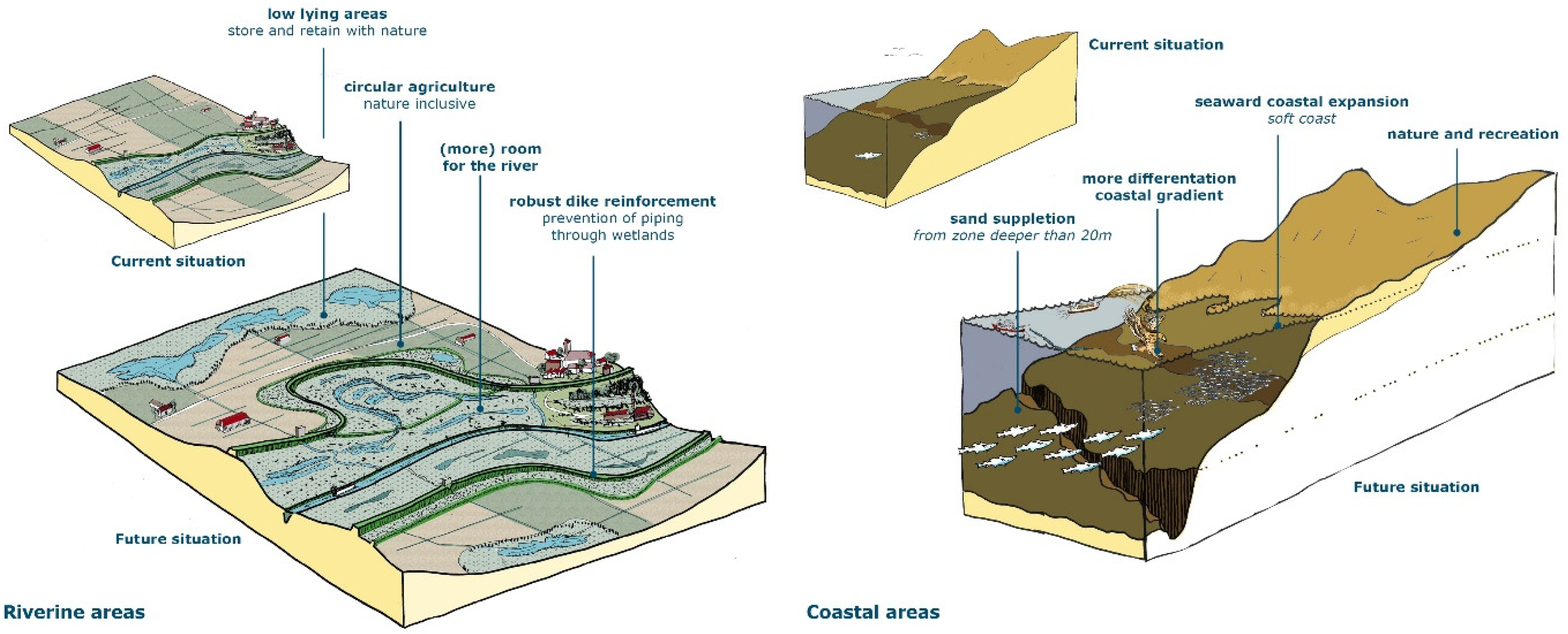
3.2.2. Coastal Zone Holland

The second local exemplar was from the Coastal Zone in the west of the Netherlands (see Figure 2). The time horizon in this case was 2070. This Coastal Zone is a delta covering a substantial part of the coastal sea and dune area of the province of South Holland and the adjacent polders. The region is characterised as a highly urbanised area located near the coast, a low-lying area of peat land and polders. The main climate change risks are sea level rise, urban heat islands, droughts, extreme rainfall, flooding, and salinisation.
In this case, the future perspective was developed in a collaborative iterative design process among local public partners, strategic policy officers responsible for the urban spatial economic development of the four large municipalities, the province of South Holland, the National Forestry Agency (SBB), the Economic Board of South Holland, and the four regional knowledge institutes of Delft, Den Haag, Leiden, and Wageningen (location Den Haag).
The starting point was the NL2120 vision described before [12], the climate change scenarios, and the underlying principles of nature-based solutions. Within the first online design workshop the vision and the principles were discussed and applied to the region. Collaboratively, four distinct subareas were defined: the North Sea, the coast and the dunes, the city, and the polder. As the urban area is a complex system, the partners decided to develop two complementary concepts: the green city, focusing at a natural perspective, and the smart city, with a focus on socioeconomic perspectives. Participants filled these concepts with ideas and examples from their specific domains and their institutional backgrounds. Designers subsequently developed maps and artist impressions.
Other starting points and ”design” principles for the collaborative process were the integrated approach based on the mission-driven innovation policy [43], aiming at innovations for solving societal problems, and a broad prosperity concept of regional development, in which the aim was to balance natural, social, and economic values. In a follow-up workshop, these principles were agreed among the various partners, with a common drive and commitment for follow-up initiatives, explorations, demonstrations, and implementations of the partners, collaboratively. Moreover, the need for extension of the partnership was agreed upon.
To offer a long-term perspective within the Coastal Zone, future narratives were developed for the different landscapes (or subareas) of the region, consisting of collages, maps, and stories (Figure 5). Moreover, an integrated perspective at the level of the Coastal Zone Holland was developed, with relations between the different landscapes and functions. Five subareas were distinguished and elaborated, with their specific innovation challenges, opportunities, and directions for solutions, as well as the design of future perspectives with narratives, collages of images, and mapping.
The following specific future perspectives for subareas were collaboratively defined.
  • The connection of the region with the North Sea will be strengthened. The North Sea will become an important production area for energies, protein rich food, and for growing biobased resources, next to sustainable transport, recreation, and biodiversity.
  • The Coast and Dunes need to be strengthened by nature-based solutions, in order to protect the region from sea level rise. This will be realised in combination with recreation and nature management. The dune landscape will be connected with green city infrastructures and the polders.
  • The Green City area innovations will green the city in order to decrease the heat island effect and to absorb heavy rainfall. Greening the cities will also have positive effects on biodiversity, health, and society.
  • The Smart City area includes the basic concerns that, from the perspective of climate change, urban functions cannot extend towards the low-lying parts of the region. Therefore housing, business, and mobility should be smartly combined and reconfigured within the current urban areas, searching for new multifunctional combinations, for example, at public transport hubs or at campus environments. Furthermore, walking and cycling will become more important, and a ban on car dependency is foreseen.
  • The Polder will have an important function in climate adaptation, as the landowners (often farmers) will contribute to storing the water, due to the flooding and heavy rainfall. This means that the area will become wetter and will be suitable for new crops. Agriculture will also have an important function in the mitigation of carbon emissions and in nature management and recreational services. Housing is only possible floating on the water.
The commonly co-created future perspective was shared with political decision makers and partner networks, which has led to a broad commitment for collaboration at the innovation pathways within the different subareas, as well as focusing on further broadening the partnerships with the private sector and the broader society in follow-up initiatives.

4. Results

The visioning processes of the two cases, the municipality of Arnhem and the metropolitan region in the western part of the Netherlands, ”Coastal Zone Holland”, were examined. Comparing the setup of these regional landscape-based design studies revealed insights into which aspects should be considered in such processes to ensure that the future visions developed provide opportunities to optimise the spatial planning process. Figure 6 highlights the key aspects for which similarities and differences were identified in the cases that relate to the three angles of analysis: the landscape-based approach, the design process, and the future visions formulated. These findings are further elaborated upon in the respective sections below.

4.1. The Landscape-Based Approach

The case comparison revealed three key aspects with regard to the ways to optimally consider the abiotic landscape in a visioning process: the abstraction level, the system boundaries, and the disciplinary expertise involved. With regard to the abstraction level, both cases aligned in presenting not only perspectives at the level of the entire region but also at the level of subareas within the region.
In the Coastal Zone case, five different landscape types were identified (see Section 3.2.2), each having their own specific problems, risks, and opportunities, as well as connections and integration at the level of the region. In Arnhem, the (deliberate) case study selection was of a city located on two landscape types, the glacial sand deposits and the landscape of the river Rhine. As a result, the design showed that there were different types of solutions for different landscape types. By choosing the appropriate level of abstraction, i.e., breaking down the region into landscape types, both cases safeguarded the correspondence between the design proposals and the abiotic landscape.
In the Arnhem case, it also appeared crucial to set the right system boundaries. In this case, a deliberate choice was made to extend the design beyond the administrative boundaries of Arnhem municipality. To create a good system-based design proposal it was deemed essential to look beyond the administrative systems, to fully indicate in what ways the vision was based upon the characteristics of the abiotic system. Nevertheless, drawing up a vision always entails that boundaries are set, undeniably implying that things outside the boundary are left out.
The same applies for the themes and disciplines on board. How can one decide whom to include? The Coastal Zone vision was developed within a partner network of the four large cities, the province, the National Forest Service, and four universities. As a result, different disciplines and expertise were available to cover and to utilise the landscape and natural systems optimally in order to find directions for future perspectives. In the Arnhem case, there was less attention on agricultural expertise given the urban scope; yet, this could have enriched the design and resulted in another end product. To ensure that the opportunities and constraints that landscape characteristics pose to suggested future land uses were demonstrated, it also proved important to ensure the involvement of the disciplinary experts beyond the analysis phase (i.e., to help understand the landscape DNA, see Section 3.2.1). Involving these experts in the design phase safeguarded that their input was correctly interpreted and that the landscape characteristics were optimally integrated in the design.

4.2. The Design Process

The case comparison revealed three key aspects with regard to the setup of the design process that affected the ways in which the future visions provided opportunities to optimise the spatial planning process: the level of co-creation, the stakeholder commitment, and being embedded in the local planning context. The future perspective of Coastal Zone Holland was developed as a co-design process, in close collaboration with local partners (see Section 4.1). In contrast, the Arnhem case was set up as a desk study, with the officials from Arnhem municipal being consulted on two occasions. A desk study is advantageous for being a relatively time-efficient process, especially in the COVID-19 circumstances where it would have been challenging to organise collaborative design sessions. In addition, the setup implied that in the Arnhem case only expert knowledge was on board. The advantage of this was that the people involved were not hindered by their “daily reality”, i.e., the task to solve pressing short-term issues, when having to look 100 years ahead. Likewise, it was easier to keep the vision out of the political realm. It could therefore be considered as “neutral”, a scientific product, because the municipal officers themselves were not involved. Thus, the long-term future was not what was contested, rather, the way to achieve the vision.
The disadvantage of limiting the co-creation to consulting the local stakeholders was that their local knowledge was not included, nor did the process provide the opportunity to familiarise the local civil servants with long-term thinking, thereby missing out on opportunities to embed the vision in the local spatial planning context. In contrast, the setup of the Coastal Zone case enabled incorporation of the ideas, knowledge, and aspirations of different partners. The perspective was developed with the strong commitment of the large municipalities, managed by strategic planners, which were able to mobilize within their organization the expertise on various aspects and subareas. Embedding within the local planning context proved an additional advantage of this co-creation setup; strategic planners were able to find political commitment. Although the Economic Board of South Holland participated, the commitment of the private sector was not strong. In a follow-up trajectory, the private sector, as well as citizens, will be approached and will have the opportunity to reflect and to add to the future perspective.

4.3. The Future Visions

The case comparison revealed three key aspects with regards to the characteristics of the future visions developed: their timeframes, the type and level of detail of products developed to illustrate the vision, and the target audience. Developing a future perspective with a time frame of 50 years, 2070, or 100 years ahead, 2120, helps to overcome current frames, regulations, and stakes. This effect is stronger the further the time frame is in the future, in this case, 2120. Yet, this also led to additional complexities in the visioning process. For example, in the Arnhem case, it was challenging to formulate good design principles regarding energy. Certainly, extensive technological innovation can be expected in this domain in the next 100 years, which cannot yet be foreseen.
Linked to the shorter time frame chosen for the Coastal Zone Holland vison was the point of attention of how to avoid triggering NIMBY discussions. In this case, it was found that the narratives, maps, and collages should not be too detailed and precise, in order to prevent such discussions. Similar concerns played a role in the Arnhem case, where there was uncertainty about the potential interpretation of the developed map, depicting the envisioned spatial situation of the municipality in 2120. There were concerns, especially with the consulted municipal officers, that residents would tend to look at where their own house was. Here too, the level of detail of the map was chosen accordingly. Additionally, it was decided to present the map as an illustration of six major discussion points, i.e., opportunities and threats, in the long term. Photovisual aspects were developed as an important addition to the other types of visuals, which were more in line with those of the NL 2120 study, i.e., a map and technical axonometries that were rather technical images. These choices were related to the target audience of the vision: the specific aim of the Arnhem study was to reach lay people. Accordingly, an appealing report was considered instrumental to start the discussion and also reach nonexperts. However, to connect with the local experts and potentially with local spatial planning at the municipality, it proved important to also share the methodological approach behind the vision. Given the strong focus of the Coastal Zone Holland case on the socioeconomic landscape (see Figure 5) and the aim to reach a commitment for collaboration on the innovation pathways towards the developed vision (Section 3.2.2), the vision comprised a landscape design perspective next to a socioeconomic and an organisational perspective. This balanced approach seemed thus to be particularly relevant given the specific target audience.

5. Discussion

In the results section, insights were shared regarding the aspects that should be considered in visioning processes to ensure that the future visions developed inform the desired transitions in spatial planning. The comparison of the two cases showed that designing such future landscape visions on a regional scale level can be conducted using different approaches. Yet, with these different approaches, both cases delivered visions with diverging qualities and were thereby equipped differently to inform spatial planning. This became apparent when reflecting upon the cases using the three backbones of a sound sustainability vision as suggested by [13]. These backbones constitute (1) normative qualities, (2) construct qualities, and (3) transformational qualities. The normative backbone relates to the visionary and sustainability qualities of a vision. The construct qualities ensure that a vision is “accurately accounting for complexity, coherence, evidence and specificity”, given that the vision is systemic, coherent, plausible, and tangible. Finally, the elements of a vision that determine whether it supports real-world change, are the so-called transformational qualities, i.e., whether the vision is shared, motivational, nuanced, and relevant [13]. Whereas both cases were rather comparable in terms of their normative qualities, as they both crafted a positive, desirable, landscape-based vision of a sustainable future of the case at hand, they differed in terms of their construct and transformational qualities.
In the Arnhem case, more emphasis was placed on the construct-related qualities of the vision, while the Coastal Zone Holland case was designed more with transformational qualities in mind. In the Arnhem case, for example, there was a strong focus on research for the design and the analysis, phase 1. Thereby, the landscape and trend analysis can be considered valuable for the systemic quality of the vision, in terms of the spatial and temporal system component, whereas the trend analysis and footprint studies show an example of methods that aim to make a vision plausible. Likewise, the characteristics of the end products of the study were clearly aiming to make the vision tangible, and the exploded axonometric views (see Figure 4) are clear examples of visualisation techniques that aim to show the systemic nature of the vision developed. Systemic, plausible, and tangible are three of the four qualities representative of the construct quality of a vision, the fourth being coherent [13]. In contrast, the setup of the case of Coastal Zone Holland clearly showed more emphasis on the relevant, motivational, and shared qualities. Together with nuanced, these qualities form the transformational backbone of sustainability visions. Indeed, participatory settings, as used in this case, are considered key to developing a vision that is agreed upon by and forms a common reference point of action for a critical number of stakeholders (“shared”) [13]. With the focus on the socioeconomic landscape and strategy development (see Figure 3), the setup clearly was actor-oriented and contributed to outlining the roles and responsibilities of the partners involved (“relevant”). The inclusion of strategy development in the process also illustrated that the case aimed to motivate actions towards implementing the vision; moreover, the stories, as case-specific end products, represented a vision format known to have a motivational component [13].

6. Conclusions and Recommendations

In the comparison of our two visioning cases, Arnhem and Coastal Zone Holland, it was clear that long-term visioning has very inspiring effects on the reflection about desired futures, beyond short-term local concerns. This comparison led to the conclusion that the setup of the visioning process, both in terms of the constellation of stakeholders involved as well as the methodological setup, is of crucial importance for the way a long-term vision of a sustainable future is suited to inform planning practice. The process setup, i.e., the expertise of the stakeholders involved, their level of involvement and commitment, as well as their affinity with the local planning context, in particular, determines the transformative nature of a vision and thus to what extent it can foster real-world change.
Although desk-study exercises can enhance the acceptance of the process, at the end of the day, it is crucial that all actors take part in the concrete spatial process and that they can contribute their local knowledge and opinions, so that the emerging strategies are not only tailored to the biophysical but also to the social landscape [39]. Using a participatory process to create future visions can help provide a common point of reference for the future and can contribute to creating ownership and developing accountability among the stakeholders involved [28].
At the same time, it is key to consciously choose the type of analyses to inform the design process as well as the associated design assumptions, such as the time frame, the abstraction level, and the system boundaries of the vision. These starting points determine to what extent the developed vision is realistic and systemic in nature. We follow Van Rooij et al. [15] in concluding that a “landscape-based approach” is essential to link the various spatial scales at stake, beyond the “lessons from nature” [44], as presented in the concept of “nature-based solutions” [45]. Following this suggestion, a landscape-based visioning exercise can be a valuable tool for other cities as well.
The answer to the question of how a consciously designed process of working with future landscape visions can support sound transitions in spatial planning at various scale levels is therefore multifaceted. We see five major transition opportunities for policy making and thus offer these recommendations for future landscape visioning:
  • Make optimal use of the free, daring, and, above all, inspiring character of long-term visioning in a broad spatial context beyond local concerns.
  • Take the qualities and carrying capacity of the natural system as the starting point: adopt a landscape-based approach.
  • Foster the integrative and creative nature of the design process to develop an innovative, motivational, and systemic vision.
  • Design a possible positive future in the first place rather than a mitigated or adapted world.
  • Envision fundamental transition pathways using societal trends and economic reasoning to strengthen the sustainable functioning of the landscape.

Author Contributions

Conceptualization, T.v.H., I.V., W.T., R.K., S.v.R. and M.S.; methodology, W.T., I.V., O.R., R.K. and M.S.; writing—original draft preparation, B.P.; writing—review and editing, I.V. and B.P.; visualization, I.V. and S.v.R. All authors have read and agreed to the published version of the manuscript.

Funding

This study was made possible by the management of the Environmental Sciences Group, Wageningen University & Research and by the TKI-project “Natuurlijk Basissysteem Klimaat Adaptieve Stedelijke Ontwikkeling” (BO-60-003-004), in cooperation with the Province of Gelderland. This research was funded by the Netherlands Ministry of Agriculture, Nature and Food Quality, grant numbers KB-34A-007-008 1-2C-6 (Circular & Climate Neutral), and KB-36-005-006/008 (Nature-inclusive Transitions).

Acknowledgments

We thank Sanda Lenzholzer for inspiring discussions on the design process. We gratefully acknowledge the valuable input of all experts involved in both case studies.

Conflicts of Interest

The authors declare no conflict of interest.

References

  1. Fleming, R.; Mauger, R. Green and just? An update on the ‘European Green Deal’. J. Eur. Environ. Plan. Law 2021, 18, 164–180. [Google Scholar]
  2. Senge, P.M.; Scharmer, C.O.; Jaworski, J.; Flowers, B.S. Presence: Human Purpose, and the Field of the Future; Society for Organizational Learning: Cambridge, MA, USA, 2004. [Google Scholar]
  3. EC. European Territorial Agenda 2030: A Future for all Places. In Proceedings of the Informal Meeting of Ministers Responsible for Spatial Planning and Territorial Development and/or Territorial Cohesion, Berlin, Germany, 1 December 2020. [Google Scholar]
  4. EC/UN-HABITAT. The State of European Cities 2016: Cities leading the Way to a Better Future; E.C.U. Habitat, Ed.; Publications Office of the European Union: Luxembourg, 2016; p. 216. [Google Scholar]
  5. Mens, M.; Minnema, B.; Overmars, K.; van der Hurk, B. Dilemmas in developing models for long-term drought risk management: The case of the National Water Model of the Netherlands. Environ. Model. Softw. 2021, 143, 105100. [Google Scholar] [CrossRef]
  6. Hegger, D.; Alexander, M.; Raadgever, T.; Priest, S.; Bruzzone, S. Shaping flood risk governance through science-policy interfaces: Insights from England, France and the Netherlands. Environ. Sci. Policy 2020, 106, 157–165. [Google Scholar] [CrossRef]
  7. Glas, P. ‘Spoor 2’ Briefadvies Woningbouw en Klimaatadaptatie; Deltacommissaris: The Hague, The Netherlands, 2021; p. 10. [Google Scholar]
  8. De Jonge, H. General Policy Letter of the Minister of Housing and Spatial Planning 2022; Ministry of the Interior and Kingdom Relations: The Hague, The Netherlands, 2022; p. 15. [Google Scholar]
  9. Korthals Altes, W.K. Planning reform beyond planning: The debate on an integrated Environment and Planning Act in the Netherlands. Plan. Pract. Res. 2016, 31, 420–434. [Google Scholar] [CrossRef] [Green Version]
  10. Montanarella, L.; Panagos, P. The relevance of sustainable soil management within the European Green Deal. Land Use Policy 2021, 100, 104950. [Google Scholar] [CrossRef]
  11. Raaphorst, K.; van der Knaap, W.; van der Brink, A.; Roeleveld, G. Visualization, participation and rhetoric: The discursive power of landscape design representations in participatory processes. J. Landsc. Archit. 2019, 14, 42–53. [Google Scholar] [CrossRef] [Green Version]
  12. Baptist, M.; van Hattum, T.; Reinhard, S.; van Buuren, M.; de Rooji, B.; Hu, X.; van Rooij, S.; Polman, N.; van der Burg, S.; Piet, G. A Nature-Based Future for the Netherlands in 2120; Wageningen University & Research: Wageningen, The Netherlands, 2019. [Google Scholar]
  13. Wiek, A.; Iwaniec, D. Quality criteria for visions and visioning in sustainability science. Sustain. Sci. 2014, 9, 497–512. [Google Scholar] [CrossRef]
  14. McPhearson, T.; Iwaniec, D.M.; Bai, X. Positive visions for guiding urban transformations toward sustainable futures. Curr. Opin. Environ. Sustain. 2016, 22, 33–40. [Google Scholar] [CrossRef]
  15. Van Rooij, S.; Timmermans, W.; Roosenschoon, O.; Keesstra, S.; Sterk, M.; Pedroli, B. Landscape-Based Visions as Powerful Boundary Objects in Spatial Planning: Lessons from Three Dutch Projects. Land 2021, 10, 16. [Google Scholar] [CrossRef]
  16. Pinto Correia, T.; Primdahl, J.; Pedroli, B. European Landscapes in Transition. Implications for Policy and Practice; Cambridge Studies in Landscape Ecology; Cambridge University Press: Cambridge, UK, 2018; p. 286. [Google Scholar]
  17. Primdahl, J.; Kristensen, L.S.; Arler, F.; Angelstam, P.; Christensen, A.A.; Elbakidze, M. Rural landscape governance and expertise: On landscape agents and democracy. In Defining Landscape Democracy; Edward Elgar Publishing: Cheltenham, UK, 2018. [Google Scholar]
  18. Luederitz, C.; Lang, D.J.; Von Wehrden, H. A systematic review of guiding principles for sustainable urban neighborhood development. Landsc. Urban Plan. 2013, 118, 40–52. [Google Scholar] [CrossRef]
  19. Keesstra, S.; Metze, T.; Ofori, L.; Buizer, M.; Visser, S. What Does the Circular Household of the Future Look Like? An Expert-Based Exploration. Land 2022, 11, 1062. [Google Scholar]
  20. Mansur, A.V.; McDonald, R.I.; Güneralp, B.; Kim, H.; de Oliveira, J.A.P.; Collagham, C.T.; Hamel, P.; Kuiper, J.J.; Wolff, M.; Liebelt, V.; et al. Nature futures for the urban century: Integrating multiple values into urban management. Environ. Sci. Policy 2022, 131, 46–56. [Google Scholar] [CrossRef]
  21. Kuiper, J.J.; van Wijk, D.; Mooij, W.M.; Remme, R.P.; Peterson, G.D.; Karlsson-Vinkhuyzen, S.; Mooij, C.J.; Leltz, G.M.; Pereira, L.M. Exploring desirable nature futures for Nationaal Park Hollandse Duinen. Ecosyst. People 2022, 18, 329–347. [Google Scholar] [CrossRef]
  22. Kempenaar, A.; Westerink, J.; van Lierop, M.; Brinkhuijsen, M.; van den Brink, A. “Design makes you understand”—Mapping the contributions of designing to regional planning and development. Landsc. Urban Plan. 2016, 149, 20–30. [Google Scholar] [CrossRef]
  23. Milburn, L.-A.S.; Brown, R.D. The relationship between research and design in landscape architecture. Landsc. Urban Plan. 2003, 64, 47–66. [Google Scholar] [CrossRef] [Green Version]
  24. Ahern, J. Urban landscape sustainability and resilience: The promise and challenges of integrating ecology with urban planning and design. Landsc. Ecol. 2013, 28, 1203–1212. [Google Scholar] [CrossRef]
  25. Kempenaar, A.; Puerari, E.; Pleijte, M.; van Buurenet, M. Regional design ateliers on ‘energy and space’: Systemic transition arenas in energy transition processes. Eur. Plan. Stud. 2021, 29, 762–778. [Google Scholar] [CrossRef]
  26. McPhearson, T.; Raymond, C.M.; Gulsrud, N.; Albert, C.; Coles, N.; Fagerholm, N.; Nagatsu, M.; Olafsson, A.S.; Soininen, N.; Vierikko, K. Radical changes are needed for transformations to a good Anthropocene. npj Urban Sustain. 2021, 1, 5. [Google Scholar] [CrossRef]
  27. Rotmans, J.; Loorbach, D. Towards a better understanding of transitions and their governance. A systemic and reflexive approach. In Transitions to Sustainable Development—New Directions in the Study of Long Term Transformation Change; Routledge: New York, NY, USA, 2010; pp. 105–220. [Google Scholar]
  28. McPhearson, T.; Pickett, S.T.A.; Grimm, N.B.; Niemelä, J.; Alberti, M.; Elmqvist, T.; Weber, C.; Haase, D.; Breuste, J.; Qureshi, S. Advancing urban ecology toward a science of cities. BioScience 2016, 66, 198–212. [Google Scholar] [CrossRef] [Green Version]
  29. Lembi, R.C.; Cronemberger, C.; Picharillo, C.; Koffler, S.; Sena, P.H.A.; Felappi, J.F.; de Moraes, A.R.; Arshad, A.; dos Santos, J.P.; Mansur, A.V. Urban expansion in the Atlantic Forest: Applying the Nature Futures Framework to develop a conceptual model and future scenarios. Biota Neotrop. 2020, 20. [Google Scholar] [CrossRef]
  30. Iwaniec, D.M.; Cook, E.M.; Davidson, M.J.; Berbés-Blázquez, M.; Georgescu, M.; Krayenhoff, E.S.; Middel, A.; Sampson, D.A.; Grimm, N.B. The co-production of sustainable future scenarios. Landsc. Urban Plan. 2020, 197, 103744. [Google Scholar] [CrossRef]
  31. Nassauer, J.I. Landscape as medium and method for synthesis in urban ecological design. Landsc. Urban Plan. 2012, 106, 221–229. [Google Scholar] [CrossRef]
  32. Arts, B.; Buizer, M.; Horlings, L.; Ingram, V.; van Oosten, C.; Opdam, P. Landscape approaches: A state-of-the-art review. Annu. Rev. Environ. Resour. 2017, 42, 439–463. [Google Scholar] [CrossRef]
  33. Opdam, P.; Nassauer, J.I.; Wang, Z.; Albert, C.; Bentrup, G.; Castella, J.-C.; McAlpine, C.; Liu, J.; Sheppard, S.; Swaffield, S. Science for action at the local landscape scale. Landsc. Ecol. 2013, 28, 1439–1445. [Google Scholar] [CrossRef]
  34. Star, S.L. This is not a boundary object: Reflections on the origin of a concept. Sci. Technol. Hum. Values 2010, 35, 601–617. [Google Scholar] [CrossRef]
  35. Vink, A.P.A. Land Use in Advancing Agriculture; Springer: Berlin/Heidelberg, Germany, 1975. [Google Scholar]
  36. Bakker, T.; Klijn, J.A.; Van Zadelhoff, F. Duinen en Duinvalleien: Een Landschapsecologische Studie van het Nederlandse Duingebied; University of Delft: Delft, The Netherlands, 1979. [Google Scholar]
  37. Timmermans, W.; Woestenburg, M.; Annema, H.; Jonkhof, J.; Shllaku, M.; Yano, S. The Rooted City: European Capitals and Their Connection with the Landscape; Blauwdruk: Wageningen, The Netherlands, 2015. [Google Scholar]
  38. Lemmens, P.; Blok, V.; Zwier, J. Toward a terrestrial turn in philosophy of technology. Techné Res. Philos. Technol. 2017, 21, 114–126. [Google Scholar] [CrossRef]
  39. Visser, S.; Keesstra, S.; Maas, G.; de Cleen, M.; Molenaar, C. Soil as a Basis to Create Enabling Conditions for Transitions Towards Sustainable Land Management as a Key to Achieve the SDGs by 2030. Sustainability 2019, 11, 6792. [Google Scholar]
  40. Opdam, P.; Steingröver, E. How could companies engage in sustainable landscape management? An exploratory perspective. Sustainability 2018, 10, 220. [Google Scholar]
  41. Swart, R.; Timmermans, W.; Jonkhof, J.; Goosen, H. From Urban Façade to Green Foundation: Re-Imagining the Garden City to Manage Climate Risks. Urban Plan. 2021, 6, 4–8. [Google Scholar] [CrossRef]
  42. Timmermans, W.; Lenzholzer, S.; Voskamp, I.; Struckman, L.; Maagdenberg, G.; Weppelman, I.; Mashhoodi, B.; Dill, S.; Cortesão, J.; de Haas, W.; et al. De Stad van 2120: Natuurlijk! Wageningen University & Research: Wageningen, The Netherlands, 2022. [Google Scholar]
  43. Mazzucato, M. Mission-Oriented Innovation Policy; UCL Institute for Innovation and Public Purpose: London, UK, 2017. [Google Scholar]
  44. Frantzeskaki, N. Seven lessons for planning nature-based solutions in cities. Environ. Sci. Policy 2019, 93, 101–111. [Google Scholar] [CrossRef]
  45. Scott, M.; Lennon, M.; Haase, D.; Kazmierczak, A.; Clabby, G.; Beatley, T. Nature-based solutions for the contemporary city/Re-naturing the city/Reflections on urban landscapes, ecosystems services and nature-based solutions in cities/Multifunctional green infrastructure and climate change adaptation: Brownfield greening as an adaptation strategy for vulnerable communities?/Delivering green infrastructure through planning: Insights from practice in Fingal, Ireland/Planning for biophilic cities: From theory to practice. Plan. Theory Pract. 2016, 17, 267–300. [Google Scholar]
Figure 1. Typical river landscape (left) and coastal landscape (right) in the Netherlands in 2020 (top) and the vision for the future in 2120 (bottom). Source [12].
Land 12 00038 g001
Figure 2. Map of the locations of the case studies in the Netherlands.
Land 12 00038 g002
Figure 3. Setup of the Arnhem case.
Land 12 00038 g003
Figure 4. Exploded axonometric view of the river area (Arnhem case) that illustrates the integrated nature of the proposed solutions (source: [42]).
Land 12 00038 g004
Figure 5. Setup of the visioning process of the Coastal Zone Holland case.
Land 12 00038 g005
Figure 6. Key aspects of the visioning process.
Land 12 00038 g006
Disclaimer/Publisher’s Note: The statements, opinions and data contained in all publications are solely those of the individual author(s) and contributor(s) and not of MDPI and/or the editor(s). MDPI and/or the editor(s) disclaim responsibility for any injury to people or property resulting from any ideas, methods, instructions or products referred to in the content.

