Article

Assessment Protocol to Evaluate the Degree of Conservation of Habitats of Community Interest: A Case Study for the 5220* HCI in the Westernmost Localities of Europe

by
Noelia Hidalgo-Triana
1,*,
Federico Casimiro-Soriguer Solanas
1,
Andros Solakis Tena
1,
David Manteca-Bautista
1,
Antonio Picornell
1,
José García-Sánchez
2,
Teresa Navarro
1 and
Andrés V. Pérez-Latorre
1
1
Department of Botany and Plant Physiology (Botany Area), University of Málaga, Blvr. Louis Pasteur, 33; 29010 Málaga, Spain
2
MGC Herbarium, Research Support Central Services (SCAI), University of Málaga, Blvr. Louis Pasteur, 33, 29010 Málaga, Spain
*
Author to whom correspondence should be addressed.
Land 2023, 12(1), 190; https://doi.org/10.3390/land12010190
Submission received: 14 December 2022 / Revised: 27 December 2022 / Accepted: 29 December 2022 / Published: 6 January 2023
(This article belongs to the Topic Urban Forestry and Sustainable Environments)

Abstract

:
The westernmost European nucleus of the 5220* Habitat of Community Interest (HCI) is located in the province of Málaga (Andalusia). In this area, the 5220* HCI is characterized by the presence of scrublands of Gymnosporia senegalensis subsp. europaea. This is a relict species in Europe, with inhabits only in the southeast of the Iberian Peninsula. The westernmost Iberian nuclei of the 5220* HCI are constituted by three isolated nuclei (Málaga–Rincón de la Victoria; Torremolinos; and Pizarra). These nuclei have been only partially mapped. The objectives were: to map the 5220* HCI characterized by G. senegalensis subsp. europaea in detail; to evaluate its degree of conservation (DC); and to identify the chronosequences of the evolution of this habitat from 1957 to 2021, and its fragmentation. Our results have contributed to generating a 1:10,000 scale cartography of the habitat. In general, the DC obtained was from good to excellent. With an excellent DC value, one inland locality (Pizarra) was highlighted. However, the highest reduction in the value of DC was observed in the localities of Torremolinos and Málaga–Rincón de la Victoria which, in addition, have reduced the area of occupancy (AOO) and are fragmented. It is important to note that some areas of Málaga–Rincón de la Victoria reached excellent values of DC, indicating the need to carry out protection.

1. Introduction

The 5220* Habitat of Community Interest (HCI; Arborescent shrublands with Ziziphus Mill.) is considered a priority habitat by the Council Directive 92/43/EEC [1]. This HCI has been defined by the European Commission (2013) [2] as when the presence of vegetal associations belonging to the phytosociological alliance Periplocion angustifolia occur. This alliance has G. senegalensis subsp. europaea as one of its characteristic species together with Ziziphus lotus (L.) Lam. and Periploca laevigata Aiton [3]. Following this definition, the Andalusian government [4] considers the presence of the 5220* HCI when shrublands of some of these three species occur. According to those definitions, in this study, we consider the presence of this HCI (and its assessment) following the previous works of Mendoza-Fernández et al. (2015; 2021) [5,6], in relation to the conservation of this HCI. In this sense, this HCI shows restrictive environmental conditions in the South Iberian Peninsula [4,7,8,9,10].
The current distribution of the 5220* HCI in the Iberian Peninsula is composed of the following nucleus (Figure 1) [6,11]: (1) one main nucleus located on the SE of Andalusia, which is distributed without interruption on the coastal strip between 0 and 300 m.a.s.l. (exceptionally between 400–600 m.a.s.l.), stretching from the base of Sierra de Almijara (Nerja, Málaga) to the occidental part of Cabo de Gata (Almería-Níjar, Almería); (2) one fragmented nucleus, where the easternmost and northernmost localities of the species in the Iberian Peninsula stand out; these localities are situated in the proximities of Cartagena and Cabo de Palos (province of Murcia), Sierra de Callosa, and Cabo de la Nao (province of Alicante), and are allocated at 125–160 km to the main nucleus of the HCI; and (3) the westernmost nucleus located in the province of Málaga and separated from the main core of the HCI between 35 and 70 km; this nucleus is fragmented in three separated localities. Part of the nucleus 1 and the entire nucleus 3, from Granada to Málaga provinces, are defined by the presence of scrublands formed by Gymnosporia senegalensis subsp. europaea, because in these two provinces there is not Periploca laevigata and Ziziphus lotus [12].
Gymnosporia senegalensis (Lam.) Loes. (= Maytenus senegalensis (Lam.) Exell) is a paleotropical shrub belonging to the Celastraceae family. Its presence in Europe is restricted to narrow coastal strips in the southeast of the Iberian Peninsula. Its actual presence in the Iberian Peninsula is considered relict, since they are originally from tropical savannahs [6,13]. Both European and North African populations are considered distinct subspecies, named Gymnosporia senegalensis subsp. europaea (Boiss.) Rivas Goday & Rivas Mart. This subspecies differs on the nominal by its higher spinescence and the morphology of its leaves [14,15]. Although this species is considered a taxon of Least Concern (LC) for the Global IUCN Red List of threatened species [16], this plant is included in the Spanish Red List of vascular flora [17] as Near Threatened (NT). In Andalusia, this species suffers a high anthropic pressure, being catalogued in the Red List as Endangered (EN) due to the impacts of mining activities, urban planning, and agriculture [18]. With respect to legal status, in Andalusia it is considered a threatened species protected by the regional law under the Vulnerable (VU) category, sharing the same legal status with Murcia and Valencia regions [19,20,21,22]. In this context of threat for the species and its habitat, the studies about the area of occupancy (AOO) of an endangered habitat are essential to determine the extinction risk [23]. Conservation status, habitat monitoring, and their species are required for reporting under Art. Ex 17 of the Directive 92/43/EEC of habitats [1], especially in priority habitats.
The assessment of the conservation status of the 5220* HCI under Art. 17 in Spain has been carried out for the periods 2007–2012 and 2013–2018, applying the EU Methodology [24], which has consistently obtained unfavorable values (U1, Unfavorable-Inadequate). This held true also in the Mediterranean region. In both reports, the 5220* HCI obtained an unfavorable conservation status.
In the Spanish context, the monitoring of HCI established a previous protocol, based on the evaluation of the distribution area of the habitat, characteristic species, structure, and function [25]. Based on that protocol, the future perspectives of the 5220* HCI were Unfavorable-Bad (U2), although those existing in some areas of the Mediterranean area had not been assessed.
The EU has produced standardized guidelines for the 2007–2012 period that allow the comparison between Member States [24,26]. These guidelines are based on the parameters: (1) Range; (2) Area; (3) Structure and functions (including typical species); and (4) Future prospects [24], and are applied in a biogeographical or national context. However, it is necessary to develop specific methodologies that allow us to evaluate the degree of conservation at the local level to implement effective conservation management [27].
The Habitats Directive defines Special Areas of Conservation (SAC) to allow the protection of habitats and the management of habitats that form part of the Natura 2000 Network [28]. The alterations in the territory that reduce the continuous surface of vegetation and increase isolated areas (reducing habitat connectivity) are known as habitat fragmentation [28]. These impacts exhibit the need to conserve and restore protected and non-protected natural spaces [29]. Some examples of habitat connectivity conservation are currently being carried out [30,31,32]. Additionally, one of the Natura 2000 Network objectives are to provide connectivity to the natural spaces and natural habitats that compose it [33].
Mendoza–Fernández et al. (2015, 2021) [5,6] detected current threats for this 5220* HCI and an important loss of the territories in the province of Almeria, explained by the intensive greenhouse agriculture, with an evaluation based on the presence of shrublands dominated by G. senegalensis subsp. europaea. Among the Mediterranean areas, the European westernmost and isolated nuclei of 5220* HCI have not been evaluated yet, and their degree of conservation and ecological connectivity are unknown. This westernmost nucleus of 5220* HCI is totally in the province of Málaga and is integrated by three separated localities. These localities shelter the westernmost scrublands of G. senegalensis subsp. europea in Europe, cohabiting with species characteristics of the arid Iberian southeast, such as Sideritis pusilla subsp. pusilla (Lange) Pau and Zygophyllum creticum (L.) Christenh. & Byng, between Málaga city and Rincón de la Victoria [34,35] or Helianthemum almeriense Pau in the Hacho de Pizarra [36].
Until the present, knowledge about the westernmost nucleus of the 5220* HCI has only been approached from a phytosociological perspective [34,35,37]. In addition, the existent cartography has been presented on a too wide scale for the territory [6,11], which is not effective for their proper management and conservation, or has not been mapped in its totality by the Andalusian government [4]. Taking this into account, the main objectives of this paper are: (1) to create a new cartography in a 1:10,000 scale about the already known nucleus of 5220* HCI in the westernmost limit of its distribution area in the Iberian Peninsula; (2) to establish a degree of conservation (DC) of these HCI, with a general protocol based on the main criteria established by Art. 17 of the Directive; (3) to evaluate the temporal changes of the AOO of this priority HCI from the mid-20th century to the present day; and (4) to evaluate the fragmentation of this HCI. Hence, a chronosequence of the evolution of their habitat has been reconstructed in 1956 and 2021.
The cartography generated, the evaluation of the DC at a detailed scale, and the study of the fragmentation intend to be an important tool for the management and conservation of these European nucleus of the 5220* HCI, which are not yet integrated into the Natura 2000 Network.

2. Materials and Methods
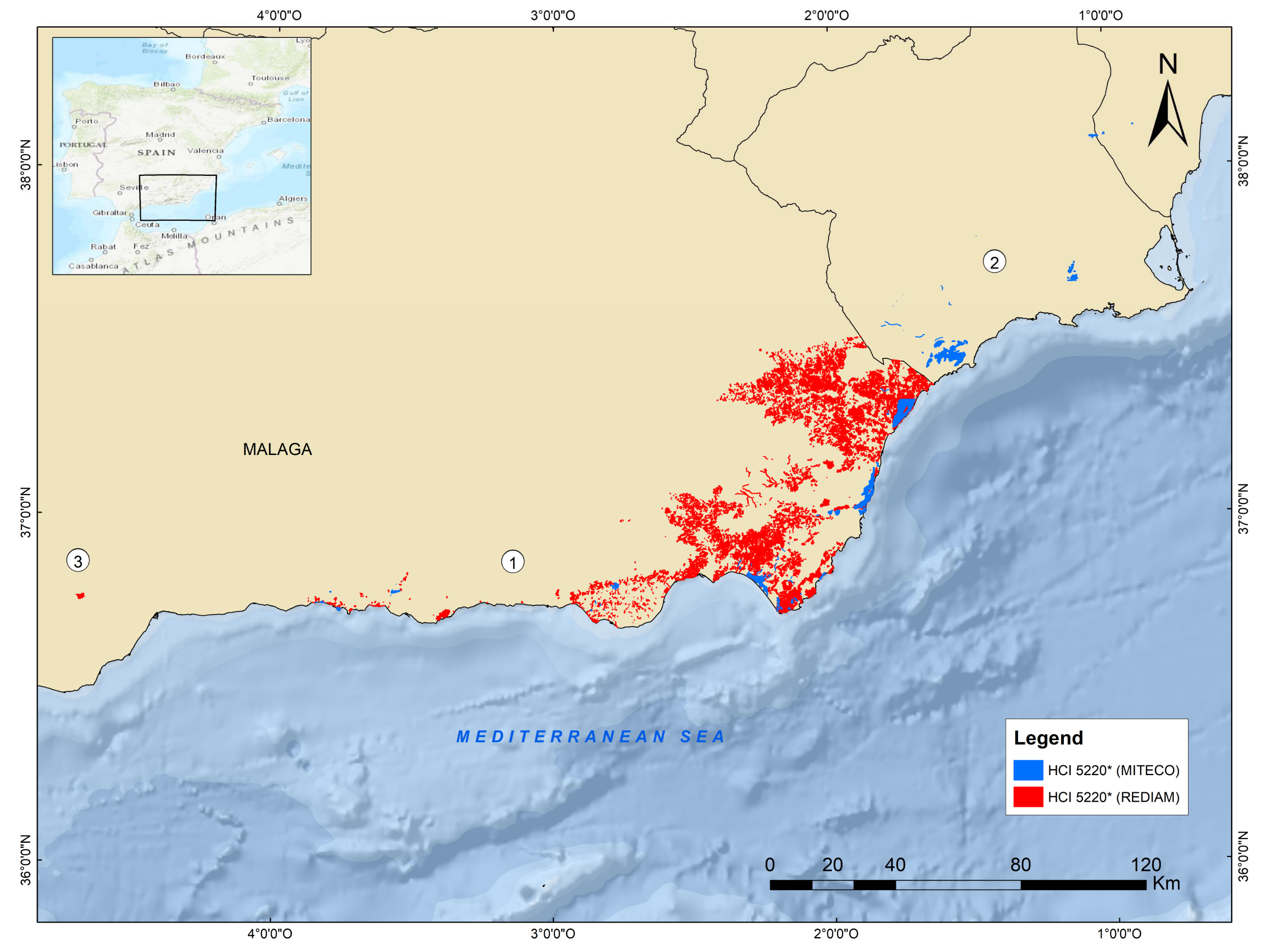
2.1. Study Area

The study area is located in the south of the Iberian Peninsula. More specifically, it corresponds to the province of Málaga, where the westernmost Iberian nucleus of G. senegalensis subsp. europaea is located (Figure 2).
G. senegalensis subsp. europaea is a typical species used for the diagnostic of the 5220* HCI in the studied area [3,4,5,6]. According to the phytosociological definition of [4], we assumed the presence of the priority 5220* HCI in the studied area when we detected the presence of shrublands dominated by G. senegalensis subsp. europaea in one of the following phytosociological entities: Calicotomo intermediae-Maytenetum senegalensis Cabezudo & A.V. Pérez 2001, and Oleo sylvestris-Maytenetum europaei Díez Garretas, Asensi & Rivas Mart. 2005.
The studied territory is included in the Mediterranean biogeographical region according to Art. 1 of the Habitats Directive. The territory is characterized by a Mediterranean macrobioclimate, with thermo-Mediterranean thermotype and dry ombrotype [38]. According to the biogeographical classification of the province of Málaga by Pérez Latorre et al. (2019) [38], the study area is included in the Malacitano–Axarquiense sector, where the locality 3.1 belongs to the Axarquiense subsector, and localities 3.2 and 3.3 are included in the Malacitano subsector. The main localities are (Figure 2):
Locality 3.1. It is situated in Málaga and Rincón de la Victoria municipalities and occupies a narrow coastal area close to the urban areas of Málaga (Cerros del Candado) and Rincón de la Victoria (Los Cantales). Here, the existent HCI is considered the most eastern locality among those studied in this work. This locality was divided into two sublocalities: one in the municipal district of Málaga capital, and the other in Rincón de la Victoria town. The Totalán river separates these sublocalities with a distance of 1.5 km.
Locality 3.2. It is situated in Torremolinos municipality, in the area known as El Pinillo, and constitutes the most southern locality, in the basal zone of the Sierra de Torremolinos, at the edge of the town of Torremolinos.
Locality 3.3. It is located in Pizarra municipality, and is considered the most northern, placed on the south face of the Sierra del Hacho, a bioclastic molasse mass located in the Guadalhorce river valley.

2.2. Cartography

The cartography of the studied localities has been obtained through a combination of bibliography and cartographical data, fieldwork, and aerial photo interpretation, following the methodology carried out by the Andalusian government for detailed scale mapping [4]. This methodology has been implemented by other authors, such as Garrido-Becerra et al. (2009) [39], Mendoza-Fernández et al. (2015) [5], and Díez-Garretas et al. (2019) [40]. Specifically, the following phases were followed:
Firstly (cartographic and bibliography database): G. senegalensis subsp. europaea presence records (as indicative of the presence of the HCI) were collected through an intensive bibliographical search, combined with the pre-existing cartography of the species. The digital cartographical sources consulted were: the cartography of the 5220* HCI by the Andalusian government [4], the cartography of the 5220* HCI by the Spanish government [13], and ANTHOS (2021) [41]. The most relevant bibliography consulted was: Cabezudo and Pérez Latorre (2001) [34]; Díez-Garretas et al. (2005) [42]; Pérez Latorre et al. (2008) [36]; Manzano Cano (2020) [11]; Mendoza-Fernández et al. (2021) [6]. Additionally, we checked herbarium records from the Global Biodiversity Information Facility [43] and herbarium records of the MGC Herbarium. A study of the ecological requirements of the HCI, based on the existent cartography, was elaborated to find new possible localities, filtering the obtained data to avoid errors (ombrotype, lithology, and thermotype shapefiles) [44].
Secondly (photointerpretation and homogeneous polygons of vegetation): the collection of this information allowed the creation of a previous photointerpretation of the territory using aerial photographs, which permits us to create a visual delimitation of homogeneous vegetation units (polygons). Subsequently, the delimited areas were digitalized using a geographic information system (QGIS 2022), obtaining previous cartography at a 1:10,000 scale.
Thirdly (fieldwork): During the fieldwork periods between 2019–2021, we visited all previously established polygons to confirm the presence of shrublands of G. senegalensis subsp. europaea and collected different data (mainly phytosociological inventories) that supported the photointerpretation of the vegetation units and helped us to define the ecological requirements of the species and the HCI.
Finally: we obtained the final cartography at the 1:10,000 scale of the three studied localities, which included a mesh of polygons that delimit homogeneous vegetation units (numbered), obtaining the definitive current AOO) [23], calculated using QGIS2022.

2.3. Habitat Evaluation: Local Degree of Conservation (DC)

Fieldwork was conducted to evaluate the degree of conservation (DC) of the 5220* HCI, using our drawn 1:10,000 map of polygons of homogeneous vegetation. The evaluation method for the DC was created following the report developed by the European Commission (2013) [2] and Tirado (2009) [10], but adapted for a local scale. Thus, our evaluation was based on three criteria (Table 1):
For each shrubland polygon drawn in the different studied localities, we calculated the three criteria as follows: (A) Number of individuals of the typical species of the 5220* HCI, referred only to G. senegalensis subsp. europaea, which is considered the unique characteristic species of the 5220* HCI in the study area, according to the definition of REDIAM, which assumes as the definition for the presence of this habitat the presence of shrublands dominated by G. senegalensis subsp. europaea [4]; (B) the habitat coverage estimating the area covered by the habitat based on the interpretation of the digital orthophotography. We considered it 100% coverage when the HCI occupied the total area of the polygon; and (C) the presence of alien species [12] and/or ruderal communities, according to Rivas–Martinez (2011) [45], which can be in relation with the invasion degree or degree of anthropization, according to the method proposed by Sánchez–Almendro et al. (2018) [27]. Three categories of parameters for the DC were obtained for each criterion (Table 1).
The sum of the parameters defined the value for the DC for each polygon, with 15 being the highest value (good conditions) and 3 the lowest (unfavorable conditions). Three qualitative values were possible: (1) values between 3–5 defined a reduced degree of conservation; (2) values between 6–9 defined a good degree of conservation; and (3) values between 10–15 corresponded to excellent degree of conservation. Finally, we calculated the DC of the studied localities with the average value of the polygons belonging to the locality, and compared them between these localities.

2.4. Estimation of the Potential Habitat Loss

A temporal study was conducted using the black and white digital panchromatic orthoimages of Andalusia, taken in 1956–1957 [46], 1:33,000 scale, 1 m resolution, as well as the originated cartography from our fieldwork based on the color orthoimages of Andalusia taken in 2020, 50 cm resolution. Photo-interpretation of AOO (potential AOO) according to the studied HCI was conducted at a scale of 1:5000.
A comparison between the resulting maps for the two studied years (1957 and 2021) was made by calculating the reduction of the AOO.

2.5. Fragmentation of the Habitat

For estimating the fragmentation of the habitat of the studied localities, four different metrics were considered for the cartography derived from the previous phases: Clumpiness Index (CLUMPY), Normalized Landscape Shape Index (nLSI), Area Weighted Mean Core Area Index (CAI_AM), and Perimeter-Area Fractal Dimension (PAFRAC) [47,48,49]. They have been reported to be among the most independent metrics, with respect to the size of the studied surface, and thus, among the most robust metrics. They were calculated by means of the landscape metrics package implemented in R software [50,51], which integrates the main metrics of FRAGSTATS software [49].
CLUMPY measures the aggregation of the nucleus and ranges from −1 to 1, with −1 being maximal disaggregation, 0 for random distribution, and 1 for maximal aggregation [49]. nLSI measures the ratio of the edge length of the populations in relation to their hypothetical maximal edge length (i.e., edge/area ratio). Values range from 0 to 1, with this last value being the maximum disaggregation [47,49]. CAI_AM measures the mean percentage of the core area (inner area) in relation to the total plan community area (including edges). It is weighted by the area of the plant community, which ranges from 0 to 100, with this last value being the highest percentage of the core area [49]. PAFRAC measures the shape complexity of the population shape, and it ranges from 1 to 2, with 2 being the value for the most irregular shapes. It was calculated for the whole study area given that it needs at least 10 population nuclei to be calculated [48,49].
CLUMPY, nLSI, and CAI_AM metrics were calculated for both the individual population (i.e., Málaga–Rincón de la Victoria, Torremolinos, and Pizarra) and the whole study area in the two studied years (1957 and 2021). The PAFRAC metric was uniquely calculated for the whole study area, given that it requires more than 10 population nuclei.

3. Results

3.1. Updated Cartography

Cartography based on polygons of homogeneous vegetation in a 1:10,000 scale of the actual presence of the three westernmost isolated localities of the 5220* HCI has been developed. Here highlights the new cartography of locality 3.1 (Málaga–Rincón de la Victoria; Figure 3) and of locality 3.2 (Torremolinos; Figure 3), which until now had not been mapped.
However, we did not find the presence of the shrublands of G. senegalensis subsp. europaea in the similar areas sampled, which were areas with potential ecological characteristics for the presence of the 5220* HCI.

3.2. Degree of Conservation (DC) of the Studied Localities

The results for the degree of conservation (DC) of the three studied localities are shown in Table 2:

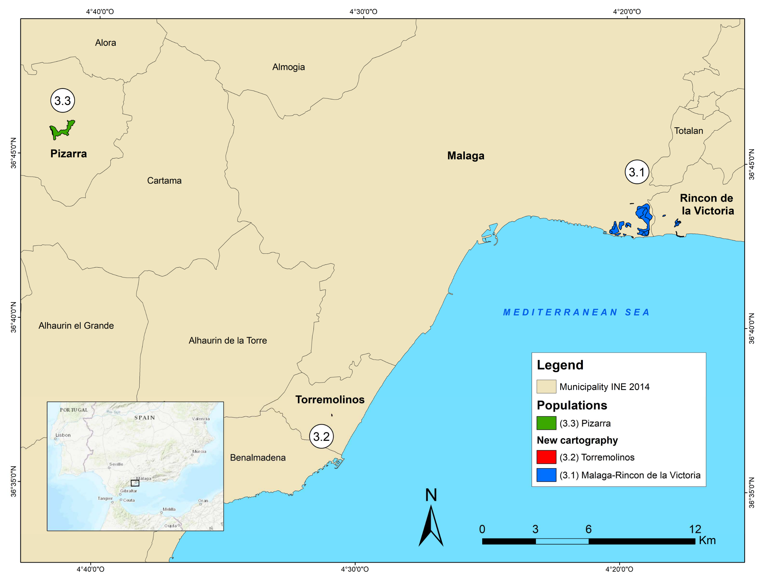
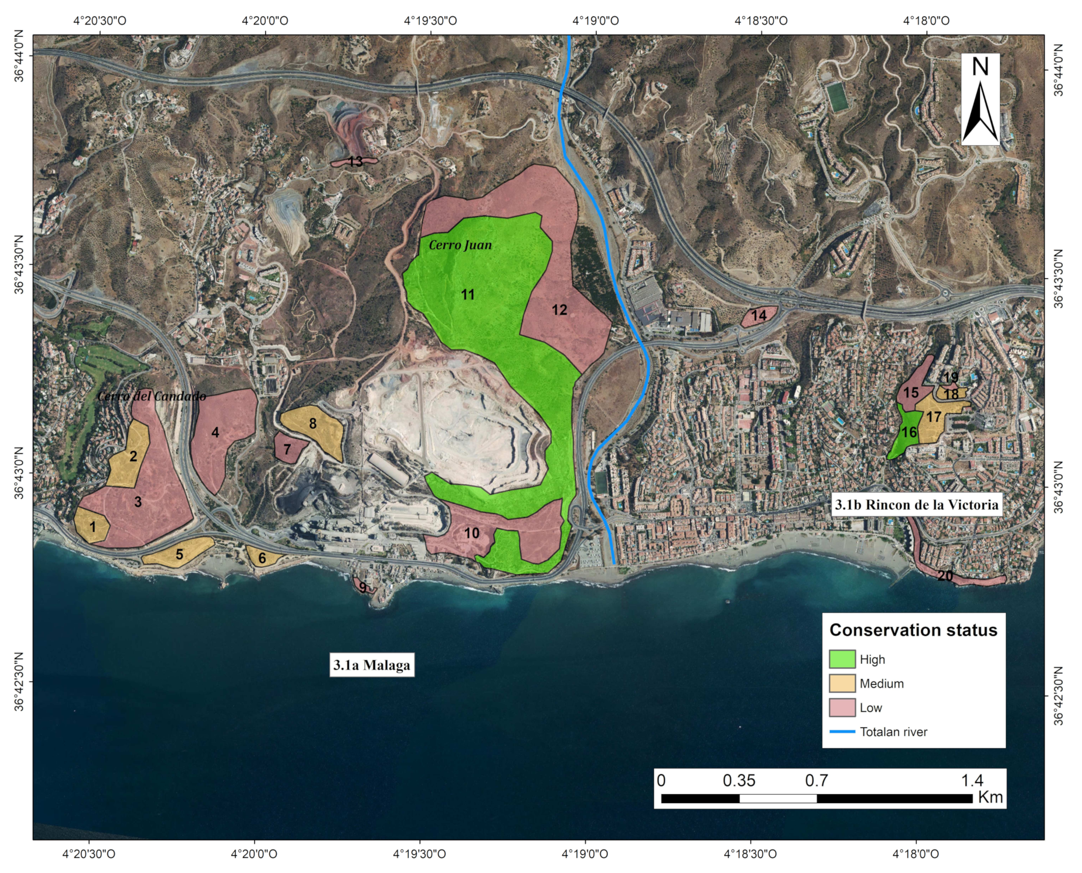
3.2.1. Degree of Conservation of the Locality of Málaga–Rincón de la Victoria (Polygons from 1 to 20)

Málaga–Rincón de la Victoria locality is allocated in an altitudinal range between 10 and 240 m.a.s.l., with the lowest developing in some coastal cliffs and the highest in the summit of Cerro Juan hill, growing on thin soils, karstic rocks, or vertical rocks (Figure 4; Table 2; polygons from 1 to 20).
The obtained results of DC for each sublocality are described as follows:
Degree of conservation (DC) of the sublocality 3.1a (Málaga, polygons from 1 to 13): this sublocality is located entirely in the municipality of Málaga city. It includes the hills of Cerro del Candado (119 m.a.s.l.) and Cerro Juan (240 m.a.s.l.), from the top of their peaks to 10 m.a.s.l., where small cliffs are directly influenced by the sea (water beaten). Practically all of the G. senegalensis subsp. europaea shrublands of these localities are located on Jurassic limestones, with only a reduced part allocated on dolomites or sandstones.
This sublocality showed an AOO of 126.3 ha and an average good value of DC (6.69; Table 2). Only 42.44% (53.6 ha) of the surface of this sublocality reached an excellent value of DC (polygon 11, Cerro Juan; Figure 4), while the rest of the surface (57.56%) reached good and reduced values.
Figure 4 shows how this sublocality is affected by limestone and dolomite mining and the construction of urbanizations and roads.
Degree of conservation (DC) of the sublocality 3.1b (Rincón de la Victoria, polygons from 13 to 20): this sublocality belongs to the municipality of Rincón de la Victoria. It occurs from the highest Archaeologist Park of the Mediterranean (100 m.a.s.l.) to the 10 m.a.s.l. of Los Cantales vertical sea cliffs area. The lithology of the area is dominated by Jurassic limestones and, to a lesser extent, conglomerates and calcareous sandstones.
This sublocality showed an AOO of 10.3 ha and an average good value of DC (6.4; Table 2). Only 17.48% of the surfaced polygons reached an excellent value (polygon number 16; Table 2), with 57.14% presenting a good value, and the rest reaching a reduced value.
As Figure 4 shows, this sublocality is surrounded by urbanizations that divide the AOO into two small separated zones.

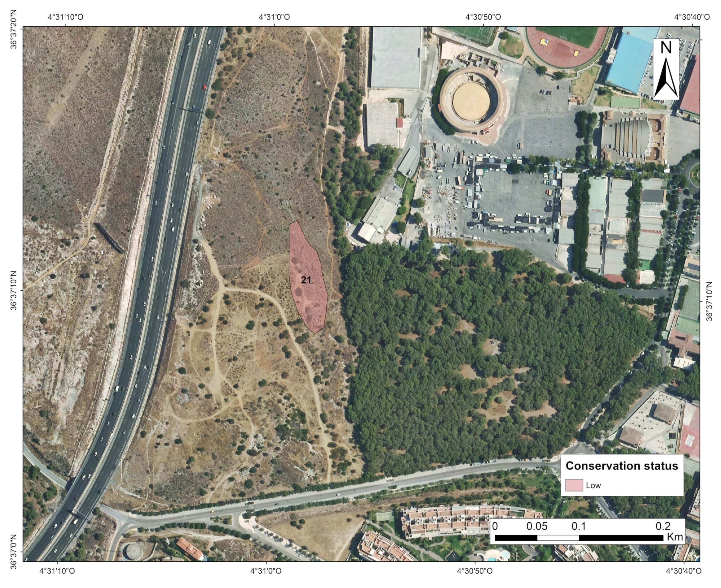
3.2.2. Degree of Conservation (DC) of the Locality of SIERRA de Torremolinos (Polygon 21)

The detected shrubland of the 5220* HCI is currently the southwesternmost locality of the HCI. It is allocated in the lower part of Torremolinos municipality (Figure 5).
It consists of a rocky zone with open G. senegalensis subsp. europaea shrubland with only one polygon (polygon 21), a reduced AOO of 0.4 ha, and a DC of 5 (reduced value; Table 2). Our fieldwork detected only 25 individuals of G. senegalensis subsp. europaea, including those forming a rupicolous shrubland in dolomite cliffs and with a high presence of invasive taxa. Roads and urbanizations were detected in the surrounding area (Figure 5).

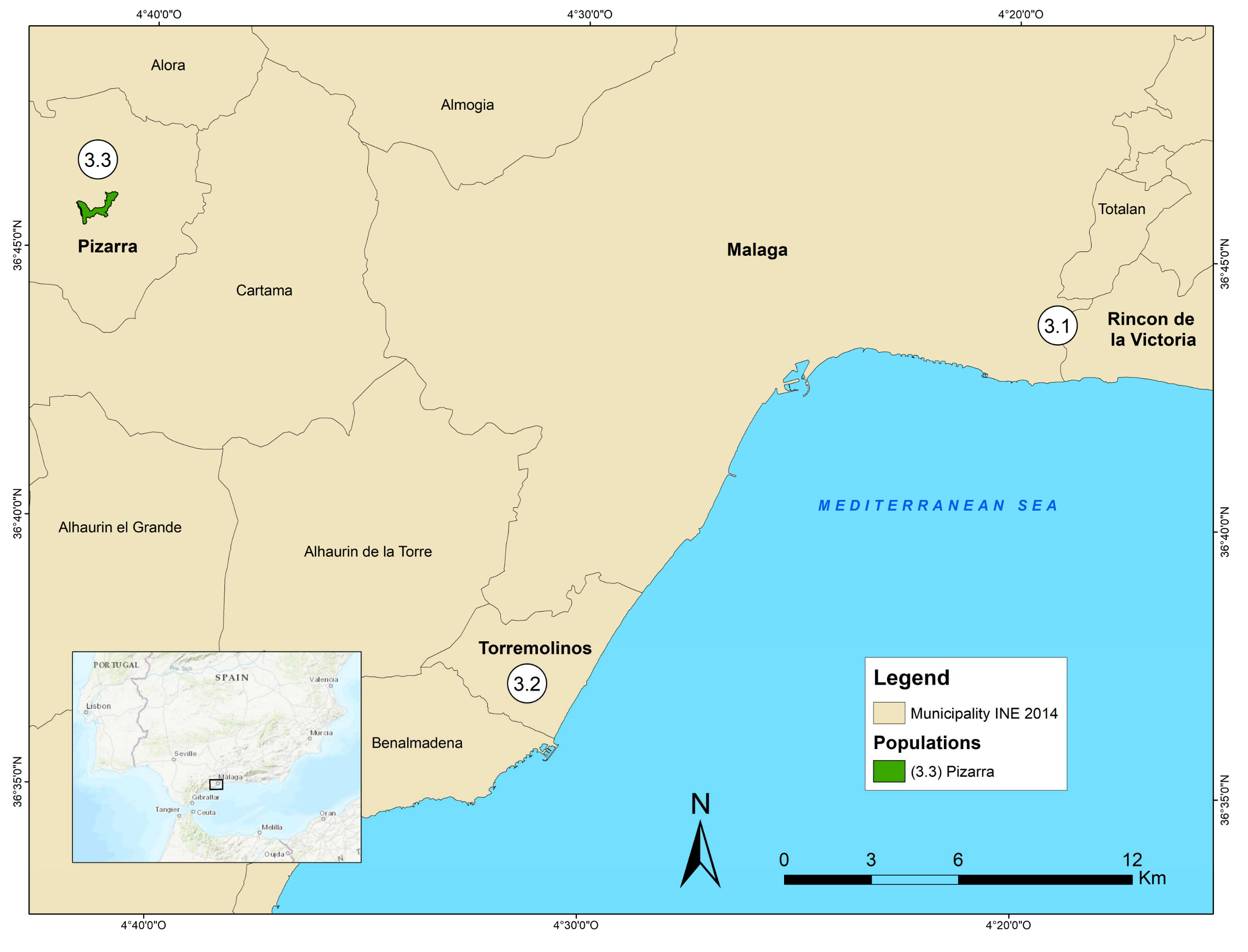
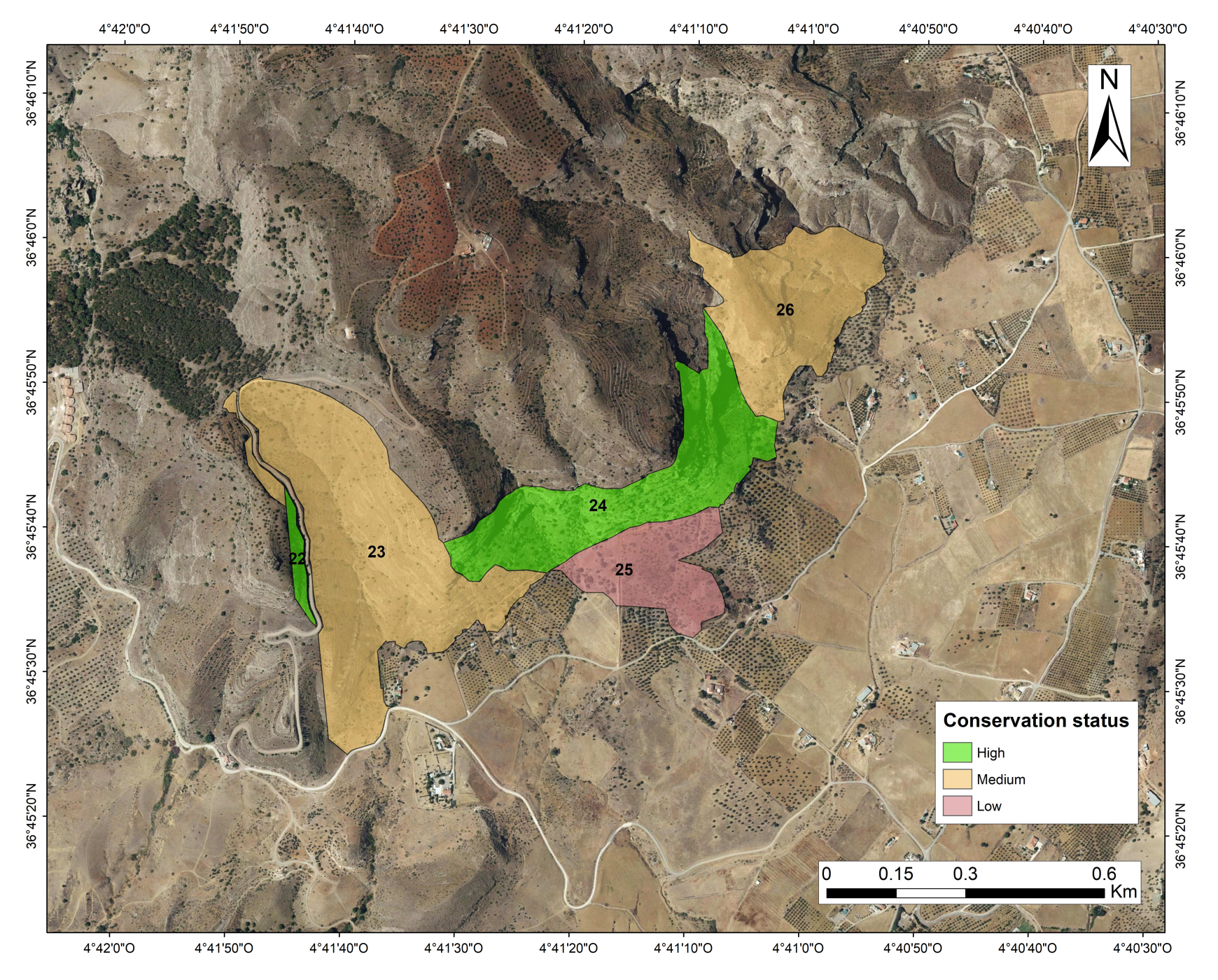
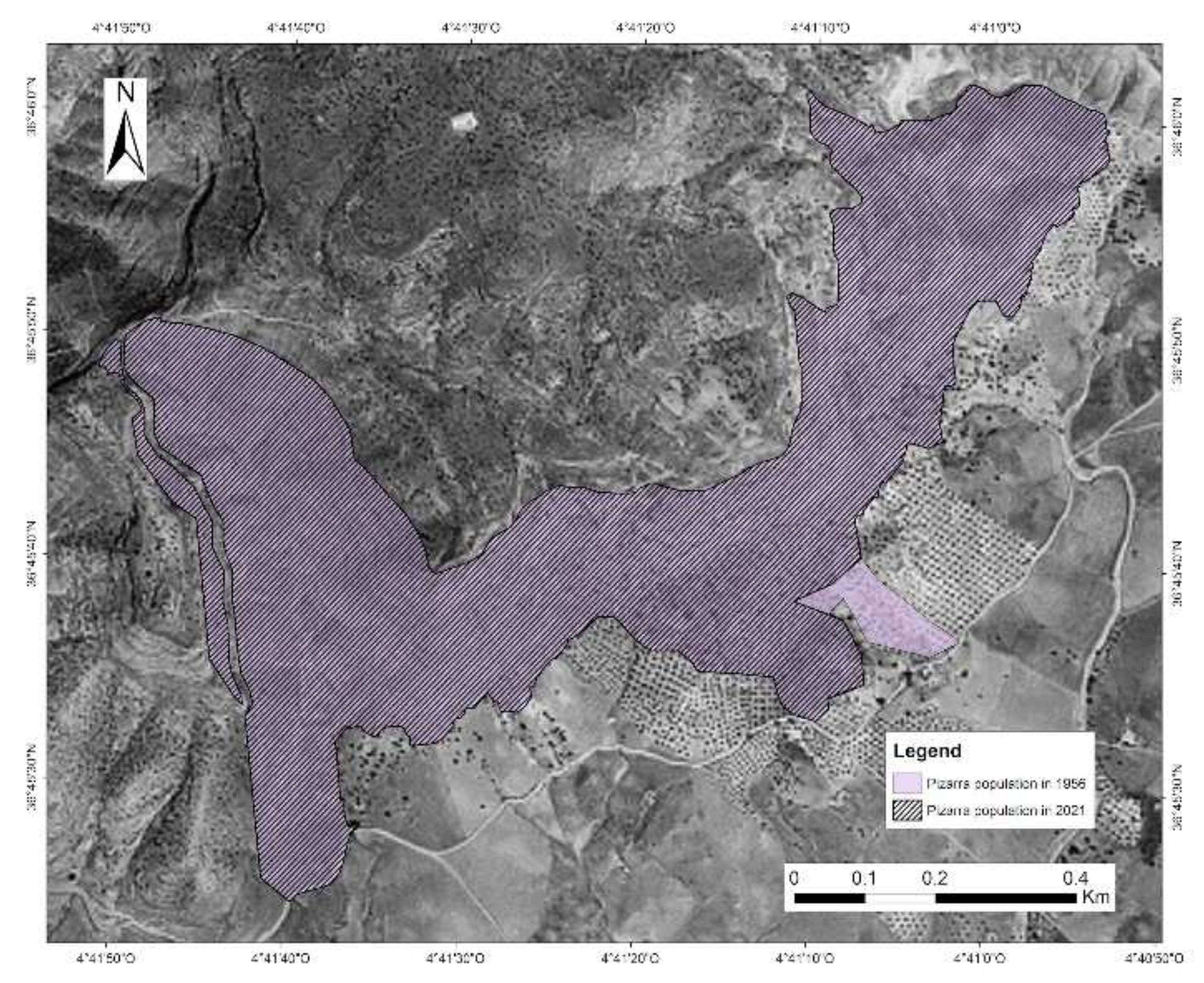
3.2.3. Degree of Conservation (DC) of the Locality of Sierra de Pizarra (Polygons from 22 to 26)

This locality is the northwesternmost locality studied. It is ubicated on the south-eastern slope of the Sierra del Hacho (municipality of Pizarra). The HCI is characterized by shrublands of G. senegalensis subsp. europaea in mountainsides with slopes between 45–90° high isolation, south orientation, bioclastic molasses, and sandy-textured lithosols.
The AOO of this plant community is 47.4 ha (Table 2). Concerning the DC of the plant community (Table 2 and Figure 6), it reached an excellent value (8.6). The 25.32% of the area occupied by the habitat reached an excellent value (polygon 22 and 24); the 62.9% reached a good value (polygon 23 and 26); and only 11.39% reached a reduced value of DC (polygon 25). It should be noted that this was the only locality that reached the highest value of DC.

3.3. Degree of Loss of Habitat

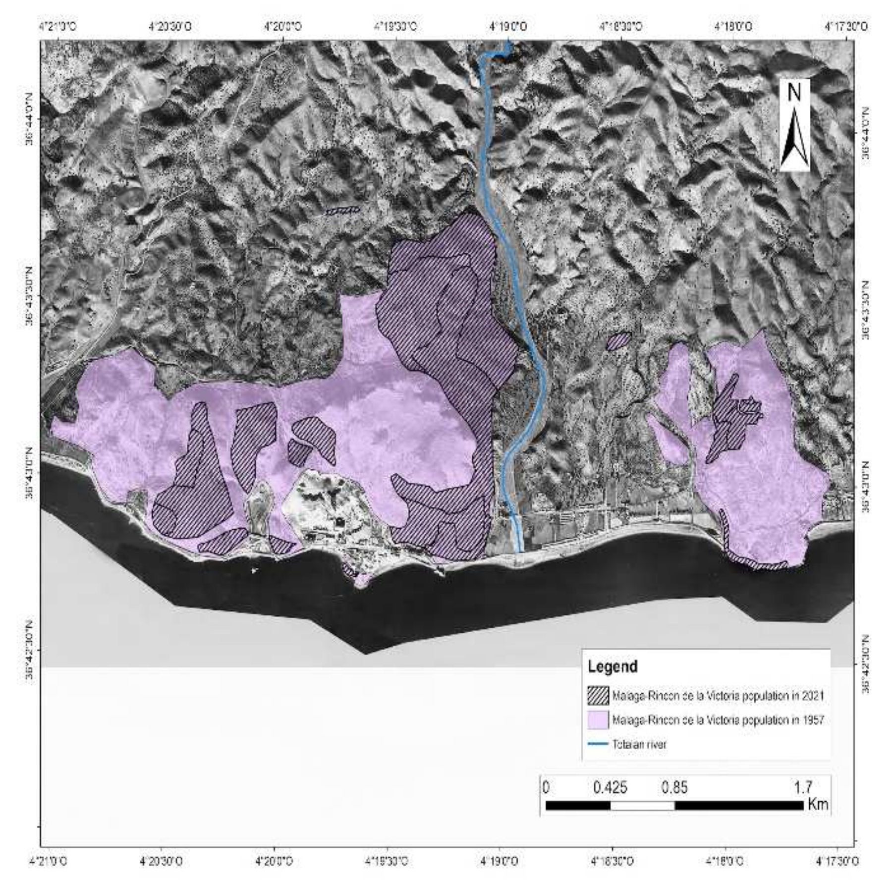
3.3.1. Locality of Málaga–Rincón de la Victoria

The current estimation of AOO of the 5220* HCI for the locality of Málaga–Rincón de la Victoria was 136.7 ha. However, the potential AOO for the period of 1956-57 was 365.5 ha. This implied an estimated loss of 62.6% of the territory potentially occupied by the 5220* HCI (Figure 7).
Sublocality 3.1a: the current AOO was 126 ha (Table 2). However, the AOO for the period 1956–57 (Figure 7) was 281.3 ha; this implies a loss of 55.1% of the territory occupied by the 5220* HCI.
Sublocality 3.1b: the current AOO is 10.3 ha (Table 2), while the potential area for the period 1956–57 was 84.1 ha (Figure 7), which means a loss of 87.7% of the territory.

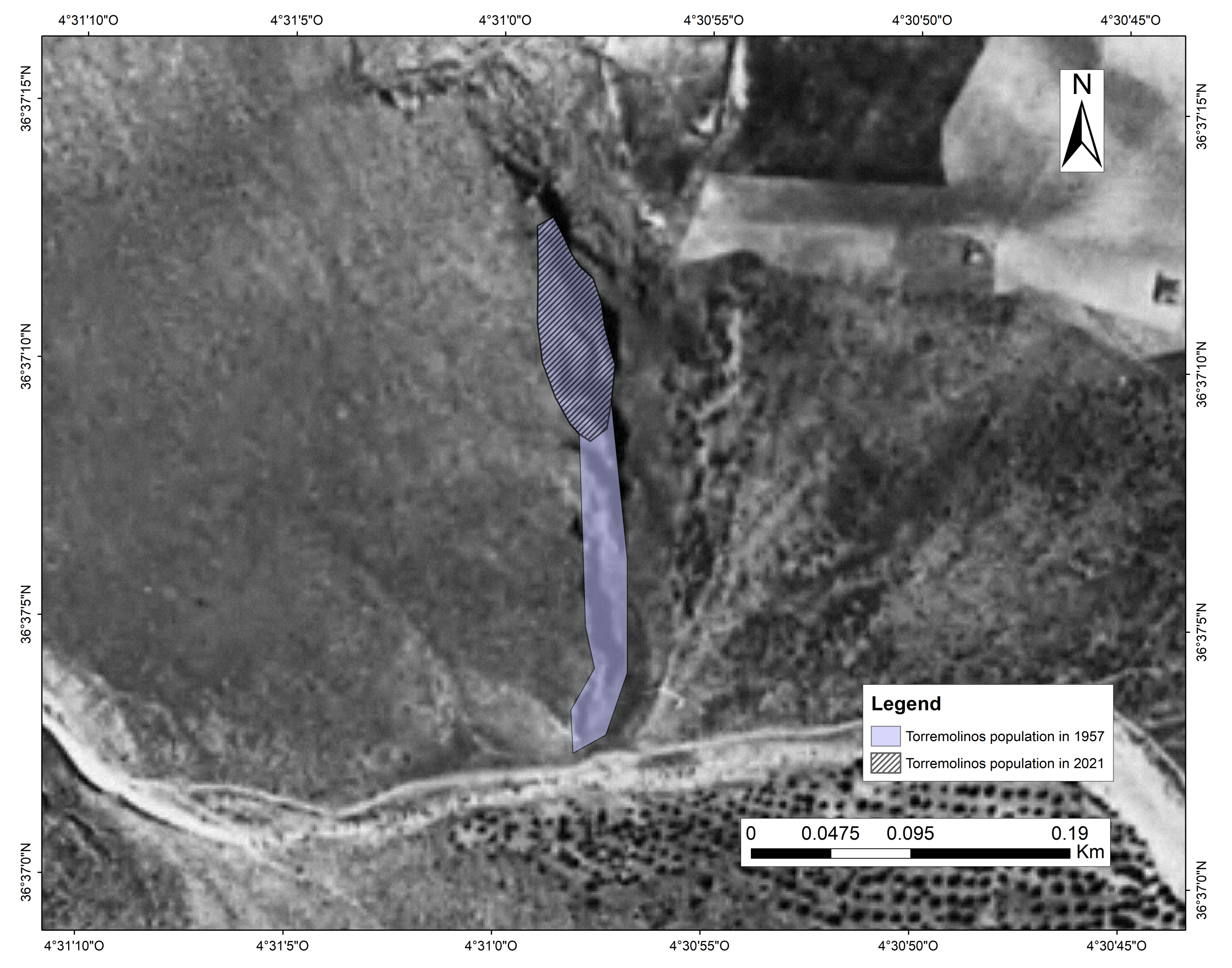
3.3.2. Sierra de Torremolinos

The current AOO the 5220* HCI of Torremolinos is 0.4 ha (Table 2), while the potential area for the period of 1956–57 (Figure 8) was calculated as 0.84 ha. This supposes a loss of 52.4% of the territory of the 5220* HCI. Figure 8 shows the activity of aggregate extraction that is developing in the area:

3.3.3. Sierra de Pizarra

The current AOO of the 5220* HCI reached was 47.4 ha (Table 2), while AOO for the period 1956–57 was 48.7, showing a loss of 2.5% of the territory. This locality is the locality that reached the lowest loss of the territory for the 5220* HCI. As Figure 9 shows, only in a small area of this locality agricultural activities are developing, while the rest of the area did not show anthropogenic activities, likely motivated by the high slopes of the area (Figure 9).

3.4. Degree of Habitat Fragmentation

Apart from the aforementioned habitat loss, the study area also experienced changes in habitat fragmentation, according to all considered metrics (Table 3):
The HCI of the locality Málaga–Rincón de la Victoria reduced the percentage of its core area (CAI_AM), reduced its aggregation (CLUMPY), and increased its edge/area ratio (nLSI), which is supposed to be an increase in the habitat fragmentation with an aggravation of connectivity. On the contrary, the Torremolinos locality (which is constituted by only one polygon) apparently reduced its habitat fragmentation, i.e., increased its core area (CAI_AM), increased its aggregation (CLUMPY), and reduced its edge/area ratio (nLSI). The locality of Pizarra slightly increased its core area, while the other metrics remained unaltered.
When considering the whole study area, an increase in habitat fragmentation was observed: the core area decreased (CAI_AM), the aggregation decreased (CLUMPY), the edge/area ratio increased (nLSI), and the shape complexity increased as well (PAFRAC).

4. Discussion

The westernmost nucleus of the 5220* HCI in Europe occurred in the province of Málaga; they are distributed in three isolated localities, without connection with the main nucleus of 5220* HCI in the Iberian Peninsula. Two of those westernmost localities of the 5220* HCI (Torremolinos and Málaga–Rincón de la Victoria) have been mapped for the first time as a result of our fieldwork. The newly generated cartography is of great relevance for two main reasons: (1) the unfavorable conservation status of the 5220* HCI found for the Spanish Mediterranean region for the period 2013–2018, and for Spain [10], which confers a special heritage value to these unmapped localities until the moment with a not-so-bad degree of conservation, and (2) the presence of the westernmost European nucleus of G. senegalensis subsp. europaea, which is an endangered species integrated into a habitat of priority interest of the Directive 92/43 [1].
Moreover, with respect to the occupied area by the HCI, Tirado (2009) [10] estimated a total area of 8836 ha, where only 5273 ha are included in the Natura 2000 Network. The current AOO of the 5220* HCI ranges between 0.4 ha (Torremolinos locality) and 136.6 ha (Málaga–Rincón de la Victoria), and the DC reached ranges between good and reduced. Their area of distribution (AOO) is being reduced (up to a 55.1% of loss), as was pointed out by Mendoza–Fernández et al. (2015) [5] in this HCI in Almeria (eastern Andalusia), due to different anthropogenic activities. Therefore, and as a whole group, the studied area needs more protection urgently, but some of the localities showed more risk of extinction than others, based on the calculated DC. This information would be of great interest to establish priority areas included in the Natura 2000 Network to elaborate management and protection politics for this priority HCI.

4.1. Degree of Conservation (DC) of the Westernmost Iberian Nucleus of the 5220* HCI

Locality 3.1 Málaga–Rincón de la Victoria: this is one of the areas where the HCI 5220* reached mainly reduced values: 42.44% of the territory for the 3.1.a locality obtained a reduced value, and only 17.48% for the 3.1.b locality reached an excellent value of DC. This fact could be explained by the high anthropogenic pressure that the area suffers. This implies that the optimal ecological conditions of the area are deteriorating [34].
The analyses of various indices of landscape fragmentation carried out on the basis of the data generated in the field work and mapping have revealed a great fragmentation of all studied localities of the 5220* HCI, caused by unplanned urbanism, road infrastructures, and the extraction of quarries. These impacts were pointed out previously by Cabezudo and Pérez Latorre (2001) [34]. From that year until now, no actions to conserve the habitat have been carried out. The high urbanization of the area explains the detection of invasive species by our fieldwork, such as Lantana camara L., Vachellia karroo (Hayne) Banfi & Galasso, Acacia saligna (Labill.) H.L.Wendl., and Cenchrus setaceus (Forssk.) Morrone, negatively influencing the 5220* habitat conservation.
Although the locality of Málaga–Rincón de la Victoria reached a reduced DC, the highest total AOO was detected in this locality. The fragmentation and anthropization of the area reveal the threats of this area and the need to start with protection measures. The sublocality of Málaga–Rincón de la Victoria inhabiting the Cerro Juan (polygon 11) should be protected, due to the excellent value of DC and the threats that the habitat presents, as Directive 92/43 requires [1]. The rest of the area of this nucleus needs restoration labor and eradication of invasive species, which could increase the reduced value of the DC.
It is important to note that the shrublands of G. senegalensis subsp. europaea in this area are close to the populations of the endemic and threatened Limonium malacitanum B. Díez, which is a typical species of the sea rock cliffs communities, also included in the 92/43 Directive (code 1240*) [1].
Locality 3.2 Torremolinos: This is considered the most threatened locality in the studied area and so is the locality that reached the most reduced DC. Its threat is explained by the current reduced AOO, the reduced number of individuals detected of G. senegalensis subsp. europaea and accompanying species, and the high presence of invasive species, such as Acacia saligna, which occurs in the same habitat of the shrublands of G. senegalensis subsp. europaea and can compete by displacing the taxa of their native places. The proximity to the roads and the urbanizations shown by the cartography are enhancing the entering of alien species that reduce the DC of the habitat. The reduction of its fragmentation metrics has been caused by a significant decrease in its total surface. This locality lost 52.4% of its surface and only a round-shaped population remained. With this shape, the fragmentation metrics are high, given that the aggregation is maximal, as well as the shape simplicity and the core area (i.e., all fragmentation metrics). Despite that, the plant community at this locality is still very fragile, as supported by the other metrics provided.
From a biogeographical point of view, this locality is very original, as it develops in the frontier of two biogeographical sectors: the Malacitano–Axarquiense and the Rondeño sectors [38]. Our fieldwork in the area occupied by G. senegalensis subsp. europaea revealed the existence of a population of Rupicapnos africana subsp. decipiens (Pugsley) Jahand. & Maire, a species protected by the Andalusian law [20] with the category EN and included in the Andalusian Red List [18]. This fact increases the need for conservation of this small patch of floristic value.
Locality 3.3 Pizarra: The locality of Pizarra shows an excellent DC, due to the high AOO reached, which can be explained by the reduced anthropogenic activity detected in the area. Anthropogenic activities are impeded by the high slopes, the very infertile rock sandstones, and the difficult access to the HCI. In addition, the reduced anthropogenic uses explain the minimal detected presence of alien species: only some agricultural activities are developed in the proximity of the area. Furthermore, the fragmentation of this locality remained almost the same during the studied long-term period.
Although the shrublands G. senegalensis subsp. europaea occur under the ecological conditions pointed out, the excellent DC of the area suggests that preventing the development of agriculture could be a good measure for the future conservation of the habitat. In addition, this area is known for the presence of several populations of endangered Rupicapnos africana subsp. decipiens (Pugsley) Jahand. & Maire, of the relict Juniperus turbinata Guss., and the eastern and semiarid characteristic Helianthemum almeriense Pau, which form a group of valuable flora [36].

4.2. Degree of Loss of 5220* Habitat in Western-Iberian Nucleus of G. senegalensis subsp. europaea

Our study reveals a great reduction of the territory occupied by this priority HCI since 1957 in its Western nucleus of distribution. Our study argues for the scattered distribution of this HCI along the southern coast of the Iberian Peninsula. This result, together with the particular ecological conditions that this species require, such as the climatic conditions of the scarce lower horizon of the thermo-Mediterranean bioclimatic belt, enhance its extinction risk [5,34].
The most worrying loss (62%) has been detected in the locality of Málaga–Rincón de la Victoria, where the anthropic use of the territory is devastating this habitat. Indeed, the fragmentation of this area was the main contributor to the increase of fragmentation detected for the whole study area. Similar results were found in the province of Almeria by Mota et al., (1996, 1998) [53,54] with a reduction of 91.5% in the AOO of the habitat.
The existence of areas with an excellent degree of conservation that are surrounded by others affected by an extreme loss of the habitat (due mainly to the existence of strong anthropic pressure) need urgent protection policies, such as the populations of Málaga–Rincón de la Victoria (Cerro Juan locality). The locality of Torremolinos has an important concern, due to the originality pointed out previously, and the worrying loss of territory. The locality of Pizarra showed a lesser degree of habitat loss (only 2.5%), due to the reduced anthropogenic activity in the area, which highlights how important it is to reduce anthropic pressure on this habitat as a whole.
Overall, the whole study area presented low fragmentation values, but it is due to the few existing localities having compact distributions. However, as observed in the locality of Málaga–Rincón de la Victoria, habitat fragmentation is a real threat and it may compromise the survival of the HCI, such as it occurs in other habitats of community interest in the Iberian Peninsula, implying a prospective extinction scenario in the near future [6].
For these reasons, anthropogenic activities should be controlled to protect this valuable ecosystem. Our field work did not detect new presence of the HCI in the suitable areas, even though the environmental conditions of some locations, such as the thermo-Mediterranean mountains of Sierra de Cártama, Monte San Anton, and Hacho de Álora [36,55,56], could be optimum for the species and the community. This fact reinforces our results, given that it proves the relict character of the species and its habitat [6].
G. senegalensis subsp. europaea patches are essential for different reasons: they are a reservoir of germplasm to ensure in situ survival of the species, and the companion species contribute to the successional process and preventing erosion [5]. G. senegalensis subsp. europaea is a target species that indicates the presence of other species considered relicts and the presence of the 5220* HCI. In addition, this is a priority HCI with relict character in the European Union, where the typical species shows sufficient plasticity to adapt to climate change [6], but the current fragmentation and destruction of the habitat could make the studied patches [10] disappear.

5. Conclusions

We can conclude that, although the Iberian westernmost nucleus of the 5220* HCI has suffered a great habitat loss in terms of AOO, this is a key territory for the future of the 5220* HCI, where some localities have some areas with a high conservation value from which the habitat could expand in the future, if conservation measures are implemented.
Our work has revealed the deficient protection of these HCI and the necessity to avoid their disappearance in the short–medium term, especially focusing on those that are directly threatened by human activities, such as the locality of Torremolinos and Málaga–Rincón de la Victoria. These threats are defined by urban expansion and the extraction of open-pit mines, actions that have caused, in the last 64 years, a loss between 52.4 and 55.1% of the AOO of these localities. However, it stands out that some areas in Rincón de la Victoria and Pizarra have reached excellent DC and, therefore, could be used as favorable reference areas.
Moreover, our results reveal that the deficient DC of these HCI and their characteristic species, G. senegalensis subsp. europaea, the fragmentation in areas such as Torremolinos and Málaga–Rincón de la Victoria, and the detected loss in the AOO, could worsen if the current and continuous anthropic occupancy of the territory persists, since such activity implies the loss of available habitat as a result of changes in land use. Our detailed data about its distribution in the southwesternmost area can constitute a useful tool to guarantee the preservation of the highest number of patches and their genetic diversity.

Author Contributions

Conceptualization, N.H.-T. and F.C.-S.S.; methodology, N.H.-T., F.C.-S.S., A.S.T. and A.P.; formal analysis, F.C.-S.S. and N.H.-T.; investigation, N.H.-T. and F.C.-S.S.; fragmentation analysis, A.P.; writing—original draft preparation, N.H.-T. and F.C.-S.S.; writing—review and editing, N.H.-T., F.C.-S.S., A.V.P.-L., A.P, D.M.-B., T.N. and J.G.-S.; supervision, N.H.-T. and F.C.-S.S.; project administration, N.H.-T.; funding acquisition, N.H.-T. All authors have read and agreed to the published version of the manuscript.

Funding

This paper was supported by the project CEIJ-006- “Evaluación del estado de conservación del litoral mediterráneo terrestre en el sureste ibérico (Málaga-Granada, España) mediante el uso de flora relevante, alóctonas invasoras y hábitats 92/43UE. Propuesta de gestión” of the Campus of International Global Excellence of the Sea. A. Picornell was supported by a postdoctoral grant financed by the Consejería de Transformación Económica, Industria, Conocimiento y Universidades (Junta de Andalucía, POSTDOC_21_00056). This publication has been also funded by the University of Malaga (“I Plan Propio de Investigación, Transferencia y Divulgación Científica de la Universidad de Málaga”).

Data Availability Statement

Data reported results can be found thorough the manuscript.

Acknowledgments

We thank the MGC Herbarium for providing the information about the existing record in the Herbarium.

Conflicts of Interest

The authors declare no conflict of interest.

References

  1. Directive 92/43/EEC. Council Directive 92/43/EEC of 21 May 1992 on the Conservation of Natural Habitats and of wild Fauna and Flora. Off. J. Eur. Union 1992, 206, 7–50. [Google Scholar]
  2. European Commission. Interpretation Manual of European Union Habitats–EUR 28; European Commission: Brussels, Belgium, 2013; 144p. [Google Scholar]
  3. Rivas-Martínez, S.; Díaz, T.E.; Fernández González, F.; Izco, J.; Loidi, J.; Lousã, M. Vascular plant communities of Spain and Portugal. Itinera Geobot. 2002, 15, 433–922. [Google Scholar]
  4. REDIAM (Red de Información Ambiental de Andalucía). HIC 5220 Matorrales arborescentes de Ziziphus. 2021. Available online: https://laboratoriorediam.cica.es (accessed on 14 July 2021).
  5. Mendoza-Fernández, A.J.; Martínez-Hernández, F.; Pérez-García, F.J.; Garrido-Becerra, J.A.; Benito, B.M.; Salmerón-Sánchez, E.; Guirado, J.; Merlo, M.E.; Mota, J.F. Extreme habitat loss in a Mediterranean habitat: Maytenus senegalensis subsp. europaea. Plant Biosyst. 2015, 149, 503–511. [Google Scholar] [CrossRef]
  6. Mendoza-Fernández, A.J.; Martínez-Hernández, F.; Salmerón-Sánchez, E.; Pérez-García, F.J.; Teruel, B.; Merlo, M.E.; Mota, J.F. The Relict Ecosystem of Maytenus senegalensis subsp. europaea in an Agricultural Landscape: Past, Present and Future Scenarios. Land 2021, 10, 1. [Google Scholar] [CrossRef]
  7. Mota, J.F.; Cabello, J.; Cueto, M.; Gómez-Mercado, F.; Jiménez, E.; Peñas, J. Datos Sobre la Vegetación del Sureste de Almería. (Desierto de Tabernas, Karst en Yesos de Sorbas y Cabo de Gata); Universidad de Almería: Almería, Spain, 1997; 130p. [Google Scholar]
  8. Valle, F. Modelos de Restauración forestal (Vol. 1–4); Consejería de Medio Ambiente: Madrid, Spain, 2004; 179p. [Google Scholar]
  9. Rivas-Martínez, S.; Asensi, A.; Díez-Garretas, B.; Molero, J.; Valle, F.; Cano, E. Mapa de series, geoseries y geopermaseries de vegetación de España, Memoria del mapa de vegetación potencial de España. Itinera Geobot. 2007, 17, 5–436. [Google Scholar]
  10. Tirado, R. 5220 Matorrales arborescentes con Ziziphus (*). In Bases Ecológicas Preliminares para la Conservación de los Tipos de Hábitat de Interés Comunitario en España; Hidalgo, R., Ed.; Ministerio de Medio Ambiente, y Medio Rural y Marino, Gobierno de España: Madrid, Spain, 2009; 68p. [Google Scholar]
  11. Manzano Cano, J. Maytenus senegalensis (Lam.) Exell en la Península Ibérica: Distribución, ecología, fitosociología y conservación. Acta Bot. Malacit. 2020, 45, 1–19. [Google Scholar] [CrossRef]
  12. Blanca, G.; Cabezudo, B.; Cueto, M.; Morales, C.; Salazar, C. Flora Vascular de Andalucía Oriental; Universidades de Almería, Granada, Jaén y Málaga: Almería, Spain, 2011; 1751p. [Google Scholar]
  13. Miteco. Ministerio para la Transición Ecológica. Dirección General de Biodiversidad y Calidad Ambiental. Datos espaciales de la Directiva Habitat. Available online: https://www.miteco.gob.es/es/biodiversidad/servicios/banco–datos–naturaleza/informacion–disponible/habitat.aspx (accessed on 14 June 2021).
  14. Güemes, J.; Crespo, M.B. Maytenus senegalensis (Lam.) Exell subsp. europaeus (Boiss.) Rivas Martínez, comb. nov. (Celastraceae), y noticias diversas acerca del mismo. An. Jard. Bot. Madr. 1990, 48, 86–88. [Google Scholar]
  15. Benedí, C. Maytenus Molina *. In Flora iberica (Vol. VIII.); Castroviejo, S., Aedo, C., Benedí, C., Laínz, M., Muñoz Garmendia, F., Nieto Feliner, G., Paiva, J., Eds.; Real Jardín Botánico: Madrid, Spain, 1997; Volume 8, 375p. [Google Scholar]
  16. BGCI & IUCN. Gymnosporia senegalensis (Amended Version of 2019 Assessment). The IUCN Red List of Threatened Species. 2021. Available online: https://www.iucnredlist.org/species/79913832/192606615 (accessed on 4 June 2021).
  17. Bañares, A.; Blanca, G.; Güemes, J.; Moreno, J.C.; Ortiz, S. (Eds.) Lista Roja de la Flora Vascular Española; Dirección General de Medio Natural y Política Forestal (Min. de Medio Ambiente, y Medio Rural y Marino)—SEBICOP: Madrid, Spain, 2008; 86p. [Google Scholar]
  18. Cabezudo, B.; Talavera, S.; Blanca, G.; Salazar, C.; Cueto, M.; Valdés, B.; Hernández Bermejo, J.E.; Herrera, C.M.; Rodríguez Hiraldo, C.; Navas, D. Lista Roja de la Flora Vascular de Andalucía; Consejería de Medio Ambiente: Junta de Andalucía, Spain, 2005; 126p. [Google Scholar]
  19. Aguilella, A. Catálogo Valenciano de Especies de Flora Amenazadas; Conselleria de Medi Ambient, Aigua, Urbanisme i Habitatge, Generalitat Valenciana: Valencia, Spain, 2010; 357p. [Google Scholar]
  20. Decreto 23/2012, de 14 de febrero, por el que se regula la conservación y el uso sostenible de la flora y la fauna silvestres y sus hábitats. Actual. Jurídica Ambient. 2012, 12, 16–17.
  21. BORM. Decreto 50/2003, de 30 de mayo, por el que se crea el Catálogo Regional de Flora Silvestre Protegida de la Región de Murcia y se dictan normas para el aprovechamiento de diversas especies forestales.
  22. DOGV. ORDEN 6/2013, de 25 de marzo, de la Conselleria de Infraestructuras, Territorio y Medio Ambiente, por la que se modifican los listados valencianos de especies protegidas de flora y fauna.
  23. IUCN (International Union for Conservation of Nature). IUCN Red List categories and criteria: Version 3.1. The World Conservation Union. Available online: https://www.iucnredlist.org/ (accessed on 4 November 2021).
  24. Evans, D.; Arvela, M. Assessment and reporting under Article 17 of the Habitats Directive Explanatory Notes & Guidelines for the period 2007–2012. Final draft April 2011. European Topic Center on Biological Diversity. 2011. Available online: http://bd.eionet.europa.eu/article17/reference_portal (accessed on 29 October 2021).
  25. Bermejo Bermejo, E.; Melado Morillo, F. Bases Ecológicas Preliminares para la Conservación de los Tipos de Hábitat de Interés Comunitario en España; Ministerio de Medio Ambiente, y Medio Rural y Marino: Madrid, Spain, 2009; 27p. [Google Scholar]
  26. Sipkova, Z.; Balzer, S.; Evans, D.; Ssymank, A. Assessing the conservation status of European Union habitats–Results of the Community Report with a case study of the German National Report. Ann. Bot. 2010, 1, 19–37. [Google Scholar]
  27. Sánchez–Almendro, A.J.; Hidalgo, P.J.; Galán, R.; Carrasco, J.M.; López–Tirado, J. Assessment and Monitoring Protocols to Guarantee the Maintenance of Biodiversity in Certified Forests: A Case Study for FSC (Forest Stewardship Council) Forests in Southwestern Spain. Forests 2018, 9, 705. [Google Scholar] [CrossRef] [Green Version]
  28. San Vicente, M.G.; Valencia, P.J.L. Causas de los procesos territoriales de fragmentación de hábitats. Lurralde Investig. Espac. 2010, 33, 147–158. [Google Scholar]
  29. De la Fuente, B.; Mateo-Sánchez, M.C.; Rodríguez, G.; Gastón, A.; Pérez de Ayala, R.; Colomina-Pérez, D.; Melero, M.; Saura, S. Natura 2000 sites, public forests and riparian corridors: The connectivity backbone of forest green infrastructure. Land Use Policy 2018, 75, 429–441. [Google Scholar] [CrossRef]
  30. Crooks, K.R.; Sanjayan, M. (Eds.) Connectivity Conservation: Maintaining Connections for Nature. In Connectivity Conservation; Cambridge University Press: Cambridge, UK, 2006; pp. 1–20. [Google Scholar]
  31. Bennett, G.; Mulongoy, K.J. Review of experience with ecological networks, corridors and buffer zones. Secr. Conv. Biol. Divers. Montr. CBD Tech. Ser. 2006, 23, 1–100. [Google Scholar]
  32. Worboys, G.L.; Francis, W.L.; Lockwood, M. (Eds.) Challenges and opportunities for connectivity conservation. In Connectivity Conservation Management: A Global Guide; Earthscan: Washington, DC, USA, 2010; pp. 342–345. [Google Scholar]
  33. Rincón, V.; Velázquez, J.; Gutiérrez, A.; Hernando, A.K.; Gómez, I.; Herráez, F.; Sánchez, B.; Juan Luque, P.; García-Abril, A.; Santamaría, T.; et al. Proposal of new Natura 2000 network boundaries in Spain based on the value of importance for biodiversity and connectivity analysis for its improvement. Ecol. Indic. 2021, 129, 108024. [Google Scholar] [CrossRef]
  34. Cabezudo, B.; Pérez Latorre, A.V. Datos sobre la vegetación termófila del litoral oriental de Málaga (España). Acta Bot. Malacit. 2001, 26, 229–240. [Google Scholar] [CrossRef]
  35. Casimiro-Soriguer Solanas, F.; Pérez Latorre, A.V.; Hidalgo Triana, N.; García Sánchez, J.; Pavón, M.; Cabezudo, B. Algunas plantas interesantes de Andalucía Oriental II (Málaga–Granada). Acta Bot. Malacit. 2013, 38, 202–207. [Google Scholar] [CrossRef] [Green Version]
  36. Pérez–Latorre, A.V.; Caballero, G.; Casimiro-Soriguer Solanas, F.; Gavira Romero, O.; Cabezudo, B. Vegetación del sector malacitano–axarquiense (Comarca de la Axarquía. Montes de Málaga y Corredor de Colmenar). Málaga (España). Acta Bot. Malacit. 2008, 3, 215–270. [Google Scholar] [CrossRef] [Green Version]
  37. IGN. Instituto Geográfico Nacional. 2021. Available online: https://www.ign.es/web/ign/portal (accessed on 16 September 2021).
  38. Pérez-Latorre, A.V.; Hidalgo-Triana, N.; Cabezudo, B.; Martos Martin, J. Mapa Biogeográfico de la Provincia de Málaga (España). Biogeographical map of the province of Malaga (Spain). Diputación provincial de Málaga y Universidad de Málaga. 2019. 2p. Available online: https://www.malaga.es/es/turismo/publicaciones/lis_cd-13211/mapa-biogeografico-de-la-provincia-de-malaga (accessed on 1 September 2021).
  39. Garrido-Becerra, J.A.; Martínez-Hernández, F.; Medina-Cazorla, J.M.; Mendoza-Fernández, A.; Pérez-García, F.J.; Cano, A.L.; Ruiz, S.M.; Mota, J.F. The application of vegetation cartography and database to the management and conservation of the biodiversity: An approach from the southeast of the Iberian Peninsula. Acta Bot. Gall. 2009, 156, 127–139. [Google Scholar] [CrossRef]
  40. Díez-Garretas, B.; Comino, O.; Pereña, J.; Asensi, A. Spatio–temporal changes (1956–2013) of coastal ecosystems in Southern Iberian Peninsula (Spain). Mediterr. Bot. 2019, 40, 111–119. [Google Scholar] [CrossRef] [Green Version]
  41. Anthos. Information System of the plants of Spain. Real Jardín Botánico, CSIC-Fundación Biodiversidad. 2021. Available online: https://www.anthos.es (accessed on 1 September 2021).
  42. Díez-Garretas, B.; Asensi, A.; Rivas-Martínez, S. Las comunidades de Maytenus senegalensis subsp. europaeus (Celastraceae) en la Península Ibérica. Lazaroa 2005, 26, 83–92. [Google Scholar]
  43. GBIF. GBIF Occurrence Download. Available online: https://doi.org/10.15468/DL.4BDQZP (accessed on 4 October 2021).
  44. DERA. Basic Spatial Data of Andalusia. 2021. Available online: https://www.juntadeandalucia.es/institutodeestadisticaycartografia/DERA/index–en.htm (accessed on 15 July 2021).
  45. Rivas-Martínez, S. Mapa de Series, Geoseries y Geopermaseries de Vegetación de España; Asociación Española de Fitosociología (AEFA): León, Spain, 2011. [Google Scholar]
  46. PNOA. Plan Nacional de Ortofotografía Aérea. 2016. Available online: https://pnoa.ign.es/ (accessed on 16 September 2021).
  47. Patton, D.R. A diversity index for quantifying habitat “edge”. Wildl Soc. Bull. 1975, 3, 171–173. [Google Scholar]
  48. Burrough, P.A. Principles of Geographical Information Systems for Land Resources Assessment; Oxford University Press: Oxford, UK, 1986; 196p. [Google Scholar]
  49. McGarigal, K.; Cushman, S.A.; Ene, E. FRAGSTATS v4: Spatial Pattern Analysis Program for Categorical and Continuous Maps; University of Massachusetts: Amherst, MA, USA, 2012. [Google Scholar]
  50. Hesselbarth, M.H.; Sciaini, M.; With, K.A.; Wiegand, K.; Nowosad, J. Landscapemetrics: An open–source R tool to calculate landscape metrics. Ecography 2019, 42, 1648–1657. [Google Scholar] [CrossRef] [Green Version]
  51. R Core Team. R: A Language and Environment for Statistical Computing; R Foundation for Statistical Computing: Vienna, Austria, 2021. [Google Scholar]
  52. ESRI. World Imagery. Available online: https://esri.maps.arcgis.com/home/index.html (accessed on 29 September 2021).
  53. Mota, J.F.; Peñas, J.; Castro, H.; Cabello, J.; Guirado, J.S. Agricultural development vs biodiversity conservation: The Mediterranean semiarid vegetation in El Ejido (Almería, southeastern Spain). Biodivers. Conserv. 1996, 5, 1597–1617. [Google Scholar] [CrossRef]
  54. Mota, J.F.; Peñas, J.; Castro, H.; Guirado, J.S.; Cabello, J. Los artos (Mayteno-Ziziphetum loti): Un hábitat en peligro de extinción. Investig. Gestión 1998, 2, 65–74. [Google Scholar]
  55. Hidalgo-Triana, N.; Pérez–Latorre, A.V. Vegetación y flora de la Sierra de Cártama (Valle del Guadalhorce, Málaga, España). Vegetation and selected flora of Sierra de Cartama (Valle del Guadalhorce, Malaga, Spain). Acta Bot. Malacit. 2013, 38, 119–149. [Google Scholar] [CrossRef] [Green Version]
  56. Casimiro-Soriguer Solanas, F.; Pérez-Latorre, A.V.; Cabezudo, B. Flora y vegetación de un espacio periurbano singular: El Monte San Antón (Málaga, España). Flora and vegetation of a unique suburban area: Mount San Anton (Malaga, Spain). Acta Bot. Malacit. 2014, 39, 179–205. [Google Scholar] [CrossRef]
Figure 1. Distribution of the 5220* Priory Habitat in the Iberian Peninsula. HCI: Habitat of Communitarian Interest. Blue represents the 5220* HCI mapped by the Spanish government (MITECO) [13], red represents the 5220* HCI mapped by the Andalusian environmental network [4]. 1. Main nucleus of 5220*HCI; 2. Easternmost and isolated nucleus of 5220* HCI; 3. Westernmost and isolated nucleus of 5220* HCI. The data source of the general cartography: Ocean Basemap layer from ESRI.
Land 12 00190 g001
Figure 2. Westernmost-Iberian nucleus of the 5220* HCI. 3.1 and 3.2 non-mapped localities in REDIAM, Málaga–Rincón de la Victoria, and Torremolinos, respectively. 3.3. Pizarra locality mapped by REDIAM (2021) [4]. The municipality is obtained from the Spanish National Geographic Institute [37].
Land 12 00190 g002
Figure 3. Updated cartography of the three studied localities of the 5220* HCI. 3.1 and 3.2 have been firstly mapped by our work.
Land 12 00190 g003
Figure 4. Málaga–Rincón de la Victoria locality cartography. The color indicates the degree of conservation (DC) of the 5220* HCI at each polygon number: the green color indicates a high DC; the orange color means a good DC; and the red color corresponds with a reduced DC. The base map used is the World Imagery, provided by ESRI [52]: layer services credits source: Esri, Maxar, GeoEye, Earthstar Geographics, CNES/Airbus DS, USDA, USGS, AeroGRID, IGN, and the GIS User Community.
Land 12 00190 g004
Figure 5. Torremolinos locality cartography. The color indicates the DC of the 5220* HCI at each polygon number: the red color corresponds with a reduced degree of conservation (DC). The enumeration of the polygons follows Table 2. The base map used is the World Imagery, provided by ESRI [52]: layer services credits source: Esri, Maxar, GeoEye, Earthstar Geographics, CNES/Airbus DS, USDA, USGS, AeroGRID, IGN, and the GIS User Community.
Land 12 00190 g005
Figure 6. Pizarra locality cartography. The color indicates the degree of conservation (DC) of the 5220* HCI at each polygon number: the green color indicates an excellent degree of conservation; the orange color means a good degree of conservation; and the red color corresponds to a reduced degree of conservation. The enumeration of the polygons follows Table 2. The base map used is the World Imagery, provided by ESRI [52]: layer services credits source: Esri, Maxar, GeoEye, Earthstar Geographics, CNES/Airbus DS, USDA, USGS, AeroGRID, IGN, and the GIS User Community.
Land 12 00190 g006
Figure 7. Málaga–Rincón de la Victoria 5220* HCI: Current and 1956–57 potential AOO.
Land 12 00190 g007
Figure 8. Torremolinos 5220* HCI: Current and 1956–57 potential AOO.
Land 12 00190 g008
Figure 9. Pizarra 5220* HCI: Current and 1956–57 potential AOO.
Land 12 00190 g009
Table 1. List of criteria used in the assessment phase of the 5220* HCI for the study area. Description and parameters used for the proposed scale. HCI: Habitat of Community Interest.
CriteriaDescriptionParameters
Reduced = 1Good = 3Excellent = 5
ANumber of individuals of the diagnostical species of the 5220* HCI (G. senegalensis subsp. europaea)1–5050–100>100
BHabitat coverage<25%25–50%>50%
CInvasion degree of alien species and/or ruderal/anthropized communities>50%25–50%<25%
Table 2. Degree of conservation (DC) and area of occupancy (AOO, in hectares -ha-) of the 5220* HCI for the study area, which are indicated by the numbers of polygons for each locality/sublocality. The summary of the assessment of DC appears with the number of individuals of G. senegalensis subsp. europaea present in each polygon (parameter A); the percentage of the area occupied by the 5220* HCI in the total area of the polygon (parameter B); and the invasion degree of alien species and/or ruderal communities (parameter C). DC is expressed in quantitative and qualitative values and the average value for the whole locality/sublocality. AOO for the 1956–57 period is shown in ha.
LocalitySublocalityPolygon NumberCurrent AOOParameter Criteria AParameter Criteria BParameter Criteria CDC (Quantitative)DC (Qualitative)AOO (1956–1957)
(3.1) Málaga–Rincón de la Victoria(3.1a) Málaga11.83339Good
23.43339Good
314.83115Reduced
48.61113Reduced
52.43339Good
60.93339Good
71.41113Reduced
83.71337Good
90.31113Reduced
109.83115Reduced
1153.655515Excellent
1224.63137Good
130.41113Reduced
Total:126.3 Mean: 6.69Good281.3
(3.1b) Rincón de la Victoria1411113Reduced
1521113Reduced
161.855313Excellent
172.75319Good
180.53339Good
190.13115Reduced
201.91113Reduced
Total: 10.3 Mean: 6.4Good84.1
(3.1) Málaga–Rincón de la Victoria Total: 136.6 Mean: 6.6Good
(3.2) Torremolinos 210.40001315Reduced0.84
(3.3) Pizarra 220.615511Excellent
2320.13137Good
2411.455515Excellent
255.41113Reduced
269.73137Good
Total: 47.4 Mean: 8.6Good48.7
Table 3. Habitat fragmentation metrics during 1957 and 2021 in the study area. Clumpiness Index (CLUMPY), Normalized Landscape Shape Index (nLSI), Area Weighted Mean Core Area Index (CAI_AM), and Perimeter-Area Fractal Dimension (PAFRAC).
LocalityMetric19572021
(3.1) Málaga–Rincón de la VictoriaCAI_AM98.29695.902
CLUMPY0.9960.989
nLSI0.0040.011
(3.2) TorremolinosCAI_AM66.40670.470
CLUMPY0.9410.964
nLSI0.0590.036
(3.3) PizarraCAI_AM94.93094.97
CLUMPY0.9880.988
nLSI0.0120.012
Whole study areaCAI_AM97.83695.607
CLUMPY0.9940.989
nLSI0.0060.012
PAFRAC1.1581.158
Disclaimer/Publisher’s Note: The statements, opinions and data contained in all publications are solely those of the individual author(s) and contributor(s) and not of MDPI and/or the editor(s). MDPI and/or the editor(s) disclaim responsibility for any injury to people or property resulting from any ideas, methods, instructions or products referred to in the content.

