Article

A Green Infrastructure Planning Approach: Improving Territorial Cohesion through Urban-Rural Landscape in Vojvodina, Serbia

1
Faculty of Agriculture, University of Novi Sad, Trg Dositeja Obradovića 8, 21102 Novi Sad, Serbia
2
Faculty of Forestry, University of Belgrade, Kneza Višeslava 1, 11030 Belgrade, Serbia
*
Author to whom correspondence should be addressed.
Land 2022, 11(9), 1550; https://doi.org/10.3390/land11091550
Submission received: 14 July 2022 / Revised: 23 August 2022 / Accepted: 7 September 2022 / Published: 13 September 2022
(This article belongs to the Special Issue Urban Sprawl: Spatial Planning, Vision Making and Externalities)

Abstract

:
Spatial and urban planning are directed towards achieving territorial cohesion as one of the sustainable development goals. Considering the hybrid concept of green infrastructure, this paper aims to provide an “ecological model” of achieving territorial cohesion in spatial and urban planning. Based on the connectivity level analysis between green infrastructure elements (green infrastructure hubs, nodes, gateways and dots), application of the GI concept guides the development of spatial planning scenarios. The application of Voronoi diagrams and landscape graph-based principles contribute to defining the shortest distances between green infrastructure elements, which resulted in the definition of the significance of structural and functional arrangement of green infrastructure dots in the matrix of the urban rural continuum in the territory of the urban-rural landscape of three case studies in Vojvodina, Serbia (Novi Sad, Subotica, Zrenjanin). As a result of this study, green infrastructure dots showed a great potential of application at the local level by developing them through landscape design with creative and artistic elements in order to achieve higher level of cohesion through visual attractivity, multifunctionality and recreation. The level of connectivity between elements of green infrastructure should be considered as an indicator of the sustainable spatial development goals achievement, in the field of nature conservation and territorial and social cohesion.

1. Introduction

The increase of urban population is accompanied by the process of urban landscapes growth where the spatial expansion of cities is four times greater than the population expansion [1,2,3], and the boundaries between urban and rural landscapes are unclear and diffuse [4,5]. Urbanization is a complex process that transforms natural and rural areas into urban or industrialized landscapes, creating “star-shaped spatial patterns controlled by the physical condition of the site and its accessibility by transport routes” [6,7]. This diffuse spatial development creates fragmented and environmentally sensitive landscape of urban- rural continuum that become “a mix of rural and urban elements”, which are named differently in scientific and professional literature—“rurban” [6], „rural-urban” compact [8], “neo-rural” [9], “hybrid landscapes” [10], functional urban area [11], urban metropolitan zone [12] and finally “urban landscapes” [13]. There is a consensus among scientists and professionals that in the era of Anthropocene and general urbanization, in which space will be dominated by Novel Urban Ecosystems, this continuum will predominantly participate in the transformation of space [14,15,16,17,18]. In relation to the quality and quantity of changes in the structure of the urban landscape and the projections of achieving spatial sustainability, it will be the platform for the scenarios of spatial planning [7,19,20].
Spatial and urban planning is directed towards achieving the sustainable development goals. The question arises as to what tools and methods researchers, planners and policy makers should apply in order to meet the demands of contemporary spatial planning, which sets territorial cohesion as a comprehensive goal to reach sustainable and balanced spatial and urban development [16,17,21,22]. The Green Paper on Territorial Cohesion (2008) insists on overcoming the connectivity and concentration problems by cross sector collaborating at different levels. One of its basic priorities is the management and realization of the connectivity between environmental, ecological and cultural elements (values) at different landscape scales that do not know borders [21,23,24,25]. Although various attempts have been made to measure territorial cohesion, the final answer on how to measure connectivity in the sense of territorial cohesion remains elusive (21). Increasingly, green infrastructure is seen as an approach to spatial planning that provides and integrates a wide range of functions within the same spatial structure and land use. Current literature analysing the concept of green infrastructure [17,26,27,28,29,30] shows that this approach can help manage land in a more sustainable and integrated way, maximizing potential multiple benefits and managing potential conflicting demands and pressures, such as housing, industry, transport, energy, agriculture, forestry, water management, nature conservation, recreation and aesthetics.
The concept of green infrastructure is primarily based on the principle of connectivity. The application of connectivity as an ecological principle in landscape planning, protection and development ensures biodiversity conservation and sustainable use of natural resources, and might be monitored by changes in the ecological cohesion index [31,32]. In the context of spatial planning, using the concept of green infrastructure as “a strategically planned network of natural and semi-natural areas designed and managed to deliver a wide range of ecosystem services” [33], there is a clear planning intention to incorporate the principles of multifunctionality and multiscale (from national to local) with this concept. As a result of the vast literature review dealing with the principles of green infrastructure planning, in addition to the principles of connectivity, multifunctionality and multiscale, which are considered to be the core principles, Monteiro et al. 2021 distinguished the principles of applicability, integration, diversity, governance, and continuity [34]. It is undeniable that within the existing spatial planning instruments policy makers consider the protection and planning of elements of green infrastructure as a green network, but lack understanding of its cross sectoral and cross scale potentials, namely green infrastructure “as a whole” [30]. Over the past decades, the concepts of territorial cohesion have brought a new dimension to debates on the application and integration of green infrastructure “as a whole” into the process of spatial and urban planning, between different sectors, and at different spatial scales [22,25,35].
A hybrid concept of green infrastructure that encompasses a wide range of principles [29,34] has the potential to achieve realization of the ecological model of territorial cohesion. The emphasized territorial (structural) and functional inclusive approach through different types of landscapes—from urban to rural, to areas of emphasized natural values, ensures the planning, formation and management of a green corridors and patches which could provide a wide range of ecosystem services (provisioning, regulating, cultural and supporting services) [35,36]. The structural elements of green infrastructure of the urban-rural continuum include protected natural units, fragments of forest and wetland vegetation, green spaces of the edge zones of settlements, different types of buffer zones, and production forests such as large parks [35,37]. Davies and others [38] note that the main functions of GI should be used to classify the elements of green infrastructure. In their research, they note that the semantic nature of the term “green” can be observed along the Gray-Green Continuum (GGC), where the functions of GI cannot be strictly defined due to its interaction with different types of landscapes. Ahern (2016) offers a typology and classification of new urban ecosystems that survive or emerge in the urban area, and are the result of intentional or indirect human activities and management (Remnant, Abandoned, Horticultural, Green Infrastructure related) [16].
In contemporary academic research in Serbia, green infrastructure is interpreted as the concept of urban and planning strategies in which landscapes are conceptualized as green infrastructure. In line with global trends, GI is increasingly used as a strategic response to climate change. According to the theoretical background, the understanding of this concept as the application of the landscape-ecological principle of connectivity, which at the same time integrates ecosystem services and provides greater landscape stability at the national—strategic scale, green infrastructure is recognised in the Spatial Plan of The Republic of Serbia (2010–2020) [17,39,40]. At the municipal level, the Plan for the General Regulation of Green Spaces of the City of Belgrade (2019) developed a concept of green infrastructure through the core, inner and outer ring of a well-known and structuralised green spaces system [17,39]. Although the GI concept appears in spatial plans, in connection with maintaining biodiversity and nature protected areas, it is still little known even among presumably well-informed spatial planning officials. In addition to common scepticism toward the new concept, we should be aware that GI competes with several well-introduced instruments within spatial planning (greenways, urban green network). As noticed by many scholars [34,35,36], and Serbian experience confirms [35,41], there is an obvious problem of understanding the GI concept “as a whole”, and its multifunctional and structural concept. The reason might the lack of instruments as well as a methodological approach which could provide insights into the realisation of multiple goals that can be combined into one measure. Less attention has been paid to the method integrating the principal of connectivity and its metric parameters into the spatial and urban planning [35,41].
Under these circumstances—the context of fragmented and environmentally sensitive landscape of urban- rural continuum, the need to move toward territorial cohesion and difficulty to measure it, possibility to reach and measure connectivity within concept of GI “as a whole”, but lack of instruments applicable in spatial planning procedure—gives rise to the need to undertake research capable of addressing GI as a spatial planning methodological approach.
Since green infrastructure is a network that relies on the territorial aspect of the land-scape and should be the subject of planning and management, we explore a new methodological approach to GI which can perform as an “ecological model” of achieving territorial cohesion in spatial planning. We aim to establish a new classification and typology of the elements and functions of green infrastructure within the existing spatial data base, as well as to determine the modalities of their spatial prioritization for the purpose of forming a stable ecological system and increasing the degree of cohesion. This is particularly a high priority activity in the areas of the urban-rural continuum under strong anthropogenic influence, and it is necessary to set priorities for green infrastructure development [35,41].
This paper contributes to the urban-rural sustainable development debate by exploring the potential of the GI methodological approach via its application in the territories of the municipalities of Vojvodina in which the development is expected according to the principles of the urban-rural continuum. The selected areas include urban centers (Novi Sad, Zrenjanin and Subotica) as well as elements of urban landscapes with suburban and rural characteristics with developed daily migration and great economic diversification [39,42,43]. The development of areas outside urban centers is influenced by the processes of urbanization and their spatial dynamics is closely related to the socio-economic context imposed by the urban centers. Over time, these spaces will show a higher level of transformation and fragmentation, which will impair the system’s resilience and its capacity to provide valuable ecosystem services.
In order to strive for territorial cohesion as one of the sustainable development goals, this paper introduces a GI planning approach which gives information about the GI elements that have different levels of planning priorities and a cross-sectoral potential to improve the “ecological dimension” of territorial cohesion. Questions to be answered are: How can GI elements be identified, evaluated and classified within the existing database? Which analytic dimensions of landscape planning methodology should be used to measure connectivity and monitor territorial cohesion? And, does it provide a range of spatial and functional importance of each GI elements for the purpose of spatial scenarios?

2. Materials and Methods
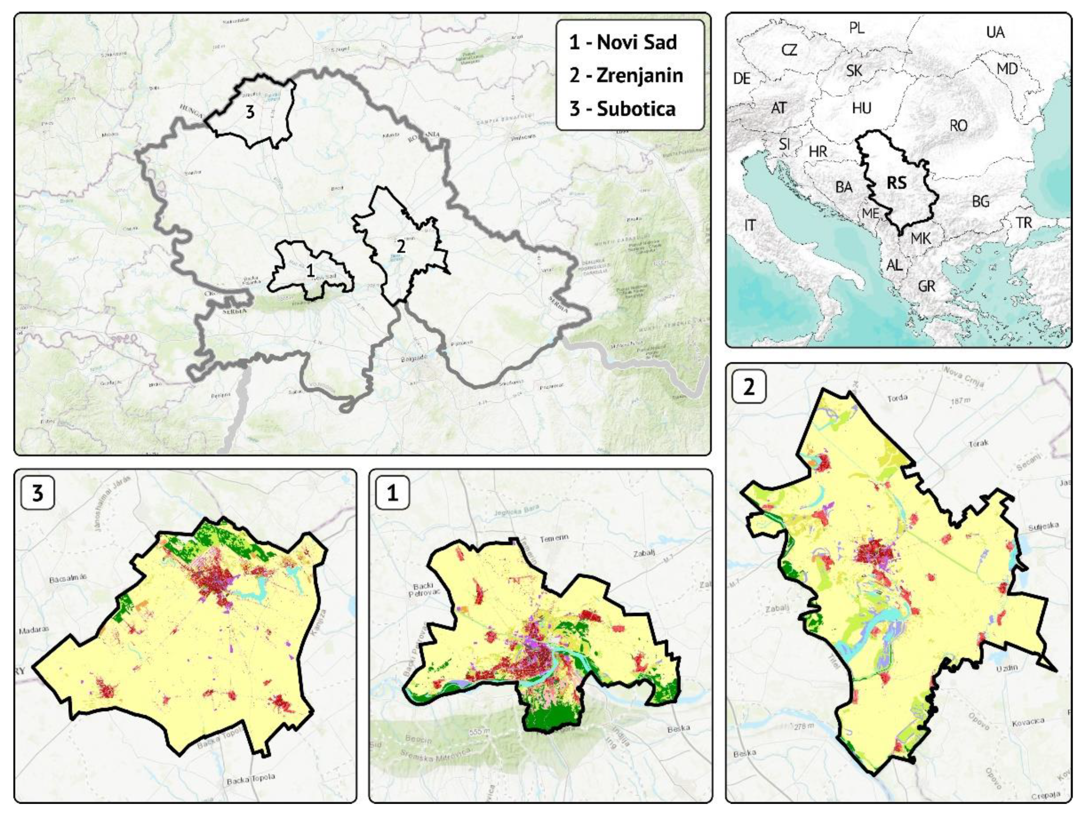
2.1. Study Sites

The investigated areas where the methodological procedure was applied are administrative units of three town settlements and municipal centers in the northern part of Serbia called the Administrative Province of Vojvodina. The territories of the towns of Novi Sad, Zrenjanin and Subotica, represent spatial units whose landscape structure has been formed over time under the dominant influence of agriculture and urban development (Figure 1). The territory of Vojvodina is traditionally used for agricultural production, and it still has areas with isolated elements of forests and steppe that stand out as examples of endangered habitats in the context of climate change and urbanization [44]. The climate of this area is temperate continental, with the Danube regime of precipitation [45,46] defined as a variant of variant of humid temperate climate with dry periods according to Köppen’s classification [47]. In addition, this area belongs to the ecoregion of Pannonian mixed forests [48] which includes subcontinental thermophilous (mixed) pedunculate oak and sessile oak forests, sub-Mediterranean subcontinental thermophilous bitter oak forests, as well as mixed forests, mixed oak-hornbeam forests, sub-Mediterranean-subcontinental lowland to montane herb-grass steppes, and azonal floodplain vegetation [49]. The basic pressure on habitat diversity is exercised by the process of homogenization of landscapes under the influence of agriculture, drainage processes, irrigation and salinization, river regulation, construction of wind farms, new industrial and business parks, energy plantations of fast-growing tree species and the presence of alien species [20]. Spaces that are recognized as valuable from the aspect of biodiversity conservation and the specific natural footprint are subject to the legal regulation of nature protection through different international and national protection categories [50].
Novi Sad is the regional and political-administrative center of Vojvodina. It is located in the central part, by the Danube River and occupies a total area of 69,884.33 ha. Novi Sad is the largest town in Serbia, after Belgrade (the capital of Serbia). According to the 2011 Census, its population is 341,625 inhabitants with a tendency of further growth [51]. A high degree of urbanization (over 70%) indicates the dominance of urban population with an increase of 4.6% in the next 25 years [52]. Significant protected areas in the territory of Novi Sad are Fruška gora National Park which is recognized as a Primary Forest [53], as well as the Koviljsko-Petrovaradinski rit Special Nature Reserve (SNR) and Begečka jama Nature park [54].
Zrenjanin is located in the eastern part of Vojvodina, on the banks of the Begej and Tisza Rivers. In terms of the area occupied, Zrenjanin (total area is 132,019.64 ha) is the largest town in AP Vojvodina and the second largest in Serbia. According to the 2011 census, the municipality has 123,362 inhabitants, with a trend of continuous population [51]. The urbanization rate of the municipality is 60.41% with a tendency of increase in urban population [55]. The most important protected areas are in the category of wetlands: SNR Carska bara, Nature Reserves Ritovi Donjeg Potisja, Okanj Bara and Rusanda Nature Park [54].
Subotica is located in the north of Vojvodina, on the border with Hungary. The total area of the municipality is 100,584.5 ha. According to the 2011 census, the municipality of Subotica has 141,554 inhabitants, with a negative trend in population movements even with 72.2% degree of urbanization [51]. In the territory of Subotica, the protected natural areas are Subotica-Horgoš Sands Nature Park, SNR Ludaš Lake, SNR Selevenj heath and Palić Nature Park [56].

2.2. Research Methodology

2.2.1. Land Cover and Green Infrastructure Classification Elements

The proposed method consists of several related phases of research arising from different theoretical and methodological approaches, which materialize the landscape elements as spatial and measurable categories of green infrastructure through the dimension of land cover (Figure 2). The research relies on the basic concept of green infrastructure according to which natural and semi natural elements of landscape structure have the capacity to provide a wide scale of ecosystem services that form a resilient space at the landscape level [57,58].
Figure 2. Methodological framework: a schematic outline of the phases—(a) present state of land use/land cover classes, (b) grey-green continuum principle, (c) novel urban ecosystems/landscapes typology and (d) spatial analysis of GI elements.
Land 11 01550 g002
The basic foundation that determines the landscape structure of the study area is the Urban Atlas of land cover created under the framework of the Copernicus program of the European Union, which represents the state of the structure of functional urban areas for 2018 (Figure 2a). Although with a certain time distance, this base offers the most comprehensive and typologically uniform approach to the structure of the surfaces of the study areas. In the first phase, a typological reclassification was performed in relation to land use /land cover classes (LULC), according to the Grey-Green Continuum (GGC) principle based on a theoretical approach of Davis et al. [38]. The landscape structure elements are classified within a ten-stage scale—from I to X (Figure 2b) in relation to their belonging to different levels of naturalness. The main reason for choosing this approach is the fact that according to this classification, the functions of natural and semi natural elements are interpreted as part of green infrastructure—especially if the natural processes that govern them, can achieve ecological functions registered on a larger landscape scale [57]. The arable land class is recognized with a neutral position in the grey-green continuum, due to a purpose that is exclusively related to intensive agricultural production that does not allow multifunctionality modalities in a given spatial context and cannot be considered as part of the green infrastructure.
The Typology of Novel Urban Ecosystems/Landscapes (NUE) [16] is the second phase (Figure 2c). In this phase the categories of spaces are grouped according to their typological affiliation to a particular origin as well as the functional status in the urban landscape into the identified classes of the GGC approach. The typology of ecosystems of urban landscapes enables the elements of green infrastructure to be classified according to their potential for improving the network of natural and nature-close elements, which in planning terms can be one of the indicators for assessing the feasibility of territorial cohesion. The following categories are included in the original classification [16]:
  • Remnant/Restored native—residual landscape elements of early stages of urbanization or revitalized with minimum alterations of autochthonous species,
  • Abandoned/Ruderal—occasionally or minimally maintained elements of the structure of high variability and compositions of species with very dynamic processes,
  • Horticultural/Formal—areas designed and managed by man for environmental benefits, aesthetics, social and recreational values and
  • Green Infrastructure related—a biotic component of green infrastructure combined with an adaptive design.
Protected natural areas are coherent and resilient systems of a formal ecological network [59], and that units which are spatially identified and protected by legislation are managed in such a way that natural values are preserved or improved. Therefore, for the purposes of this research, these landscape elements are recognized as part of the first category, i.e., Restored Native. Other natural and semi-natural landscape elements in the form of forests and wetlands outside of the nature protected areas that have a different legislative status (forestry land use or agricultural land use) are identified as Remnant native, while green spaces of urban areas are part of the Horticultural/Formal group. Landscape elements belonging to the category Abandoned/Ruderal have the most significant spatial potential to obtain the status of green infrastructure and improve the connectivity of natural and nature-close elements at the landscape scale. In addition, these elements are mainly located in the peripheral zone of populated areas. That is way they are attractive locations for the expansion of urbanized areas, which is making their future as components of green infrastructure uncertain. Therefore, in further analyses, elements representing green infrastructure components are treated through the groups Restored Native, Remnant Native and Horticultural/Formal elements.

2.2.2. Elements of Green Infrastructure and Their Connectivity

For the purposes of this research, the applied method for determining the level of connectivity between the elements that are the primary carriers of the green infrastructure function, was based on the landscape graph-based principle [60]. The method was applied to the selected groups of landscape elements resulting from previous stages: Restored native elements, Remnant native elements and Horticultural/ Formal elements (Figure 2d). Graphab application version 2.8 [61] was used, which enables the creation of graphs composed of nodes that are connected by connections based on Voronoi diagrams, which is a common approach for determining the level of connectivity [17]. A particularly significant aspect of this approach is the possibility of weighting the role of certain classes identified as the target group of GI elements in order to make the analysis of their connectivity sensitive to the significance for the stability of the landscape structure and therefore to the more complex ecosystem services they achieve in the landscape [62].
In addition, some of the landscape metrics tools were applied, which quantified the geometric characteristics of the landscape elements belonging to the green infrastructure classes in order to assess their significance for landscape functioning. Patch Analyst 5.2 software [63] was used at the patch level, where the Area-Perimeter Ratio (Apr) (EQN 1) parameter was calculated for the elements of these classes. The value of this parameter is in a synthesis of two fundamental aspects of landscape structure: composition and configuration [64]. This parameter has a long history of application for the purposes of the analysis of landscape characteristics [65,66]. High values of this parameter indicate the existence of large landscape elements of a compact form. This enables them to have a greater ecological stability as well as a dominant influence in the landscape [67].
A P R = A i , G I P i , G I
APR—Area-Perimeter Ratio. Ai.GI—area (sqm) for a particular element that is part of green infrastructure classes. Pi.GI—perimeter (m) for a particular element that is part of green infrastructure classes.
In accordance with the previous findings on the characteristics and origin, assessment of the level of connectivity as the level of dominance of green infrastructure elements in the landscape structure, the final typology of the constitutive elements of green infrastructure (Table 1, Figure 2d) was proposed. Green infrastructure hubs are the epicenters of ecosystem services, and thanks to being recognized as valuable from the point of view of nature protection they enjoy the status of formal protection, as the most significant elements of green infrastructure whose future is assured [59]. Green infrastructure nodes occupy an important place in the connection matrix between hubs and gateways. These elements have a high level of naturalness and certainly allow a certain level of ecosystem service [68]. However, the fact that they are located in land uses that are not complementary to their structure is a threatening factor for their durability. Green infrastructure gateways are isolated elements of nature in the city. As such, they are important from the aspect of providing ecosystem services, especially the ones from the group of cultural services, i.e., leisure, recreation and health and quiet enjoyment [69].
The determined connectivity levels between green infrastructure hubs, nodes and gateways indicate spatial zones in which there is the greatest absence of their interconnectivity. These zones are recognized as barriers that prevent the development of structural and therefore functional characteristics of green infrastructure and ecosystem services. In directions where the shortest path for achieving connectivity was identified using the landscape graph-based method, elements belonging to the Abandoned/Ruderal group were distinguished according to the NUE classification. According to the GGC classification, this group includes the following elements: VI—Land without current use and Complex and mixed cultivation patterns; VII—Sports and leisure facilities, Pastures and Open spaces with little or no vegetation; VIII—Permanent crops and Herbaceous vegetation associations. These elements have the potential to obtain the status of Green infrastructure dots as the lowest level of support for a network of natural and semi-natural elements which represent supporting elements of green infrastructure at the regional level [70].

3. Results

3.1. Clustering Elements of Green Infrastructure

The results of a different classification of landscape elements of the Urban atlas according to the GGC principle are shown in Figure 3 and Table 2. In all three investigated territories, the class of arable land is highly dominant (Novi Sad: 59.57%; Zrenjanin: 75.08%; Subotica: 81.35%). This results in small areas belonging to category X (forests and wetlands)—Only in the territory of Novi Sad this category accounts for 11.22%, which is the result of a larger share of Fruška gora National Park, as one of the primary motives for protecting the existence of quality forests. Categories from IV to I, which refer to different classes of artificial areas, dominate in the territory of Novi Sad (14.65%) (Zrenjanin: 5.52%; Subotica: 8.59%), given the fact that it is the second largest town in the Republic of Serbia and the administrative and economic center of Vojvodina.
After the implementation of the second phase of the research, that is, the classification of the GGC approach results according to the modified NUE concept, a slightly different picture was obtained of the ratios of surfaces that can be interpreted as part of the green infrastructure (Figure 4, Table 3).
The three selected towns in Vojvodina, Novi Sad, Zrenjanin and Subotica, with their surroundings are examples of urban landscapes in which agricultural activity is significant. That is registered through a large share of agricultural land used for intensive agricultural production ranging from 59.27% for Novi Sad and, 72.00% for Zrenjanin to 81.35% for Subotica. The shares of forest elements and wetlands outside the protected natural resources belonging to the category Remnant native elements show a certain degree of similarity: Novi Sad: 4.30%; Zrenjanin: 2.77% and Subotica: 3.26%. The shares of nature protected areas, which are categorized as Restored native elements according to the NUE modification are also similar: Novi Sad: 8.88%; Zrenjanin: 8.11%; and Subotica: 7.17%. These spaces are units with a high level of biodiversity and are part of the formal protection of natural values accordingly recognized in the functional sense as Green infrastructure hubs. They are treated as spaces in which no intervention can be made in terms of creating or shaping new elements. The role of the town of Novi Sad as the agglomeration center has influenced characterization of the territory of its administrative unit as dominated by urbanized areas (14.49%) in comparison with the other two investigated towns. This fact is also correlated with the number of inhabitants, given that Novi Sad has the largest population (341,625) as well as the largest number of employed inhabitants, which places it in the category of a large industrial center (from 20,000 to 50,000 employees). The territories of the other two towns are characterized by a smaller percentage of built-up areas, Zrenjanin–5.51% and Subotica–8.51%, which is in accordance with the lower urban center category, i.e., they represent urban areas of regional development. The population of these two towns is relatively similar, Zrenjanin–123,362 and Subotica–141,554. They both have regional importance and represent large industrial centres (from 10,000 to 20,000 employees). The different status of these towns also results in different shares of Horticultural/ Formal elements, that is, the Green urban areas class (IX): Novi Sad: 0.43%; Zrenjanin: 0.12%; and Subotica: 0.15%.

3.2. Connectivity of Green Infrastructure Elements

The Graph-based principles applied to the green infrastructure classes which are a synthesis of the GGC and NUE approaches, determined different scales of connectivity which show a significant dependence on the spatial context in which they are realized. The basic directions of connections between the classes that make up the constituent elements of green infrastructure are represented by the Voronoi diagram lines, while their intersections are represented in the form of a point that is weighted by the weighting factor of the role of a particular element in the network (Figure 5, Table 4). In addition, the value of the Area-Perimeter Ratio parameter was established, which identified the gradient of influence of individual elements belonging to green infrastructure. In relation to the model of green infrastructure functionality assessment, a typology of elements of green infrastructure was produced in relation to their level of impact on landscape structure.
In relation to the setup model of assessing the functionality of green infrastructure elements, in all investigated areas, a part of Green infrastructure hubs have been recognized within Restored native elements, i.e., nature protected areas. From the aspect of the high level of connectivity and spatial dominance, “Fruška Gora” National Park and the “Kovilj-pertovaradinski rit” Nature Reserve were distinguished in the territory of Novi Sad. The “Okanj bara” Nature Reserve was distinguished in the territory of Zrenjanin, and in the territory of Subotica the “Subotička pesčara” Outstanding natural landscape. These spaces represent highly functional entities, not only due to the presence of formal nature protection, but also due to the fact that their values of the Area-Perimeter Ratio parameter are high. This indicates their compact form and size, interpreted as the realization of ecological dominance and great influence in the investigated areas. Depending on the spatial context, Green infrastructure hubs are responsible for a variable number of connections with other elements (Novi Sad: 21.61%; Zrenjanin: 4.80%; Subotica: 13.07%), but the character of their connections is of high value.
Elements with lower values of the Area-Perimeter Ratio parameter, smaller areas and spatially distinctly linear protected natural areas, or spaces where the focus of protection is on aquatic habitats (Novi Sad: “Begečka jama” Nature Park; Zrenjanin: “Ritovi Donjeg Potisja” Nature Reserve; Subotica: “Ludaš Lake” Nature Reserve; “Palić Lake” Nature Park), as well as larger fragments of forests and wetlands are classified in the category Green infrastructure nodes. These spaces represent significant elements of green infrastructure that combine a large number of elements identified as Green infrastructure gateways. Cumulatively with Green infrastructure hub connections, this group forms the axis of connectivity of highly valued elements of green infrastructure in the surveyed areas (Novi Sad: 31.92%; Zrenjanin: 25.93%; Subotica: 33.28%).
Green infrastructure gateways hierarchically represent the lowest elements of green infrastructure. They are present in the form of small protected urban parks (mostly located in the territory of Novi Sad), nature protected areas, which are represented by a smaller percentage in the surveyed area (Zrenjanin: “Rusanda” Nature Park; Subotica: “Selevenj heath” Special Nature Reserve) as well as small scattered elements of forests in peri-urban areas, protective forests and wetlands in alluvial fans and linear natural elements along river corridors. These elements provide territorial and thus functional expansion of green infrastructure impact on the peripheral zones where urban and agricultural land use dominates. Green infrastructure gateways allow for the connection and flow of ecological processes through the landscape.

3.3. Improving the Green Infrastructure Networking

The landscape matrix is represented by arable areas, so the space for new elements of green infrastructure can be located within the smaller remaining natural and semi-natural fragments that are nested within arable areas. As this land use type is a vital resource of AP Vojvodina, the dominance of its structure and functionality tends to limit other uses. This is especially true for those that are carriers of a certain degree of naturalness and have the potential to improve green infrastructure. Grouped parts of urbanized areas also represent elements that are not primarily composed of natural and semi-natural elements, but occasionally have Horticultural/Formal, i.e., Green urban areas in their matrix which enables the spread of green infrastructure to this group as well. By applying Voronoi diagrams, a system of directions of shortest geometric distances was formed between the elements that build up green infrastructure. In these zones, elements identified as Abandoned/Ruderal according to the NUE approach have been distinguished. They have the spatial capacity to provide significant support to formal elements of green infrastructure. Abandoned/Ruderal is a “highly dynamic but manageable” group with a significant function of a “climatic buffer” [16]. In its structure, it represents a transition phase of urban and agricultural land use and accordingly emergence of the classes of Herbaceous vegetation associations, Pastures, Permanent crops, Complex and mixed cultivation patterns, etc. In relation to the above, elements of the Abandoned/Ruderal group were distinguished in the investigated areas, representing the areas with the highest potential for improving the connectivity of formal groups of green infrastructure and as such they were named Green infrastructure dots (Table 5).
Spatial units that have the highest potential to form the lowest organizational category of green infrastructure are classes that belong to category VII. Pastures, which are mostly located in the peri urban areas of the towns of Novi Sad (6.12%) and Zrenjanin (3.29%) are distinguished within this category. Since these are spaces that will be endangered by the process of expansion of settlements in the future, adequate treatment of these classes through the prism of their spatial significance as Green infrastructure dots is necessary. The territory of Zrenjanin settlement provides space for this category of green infrastructure through the class of herbaceous vegetation associations (3.72%). These areas are mainly located in the wider zones of nature protected areas in alluvial floodplains. Thai is why their importance for agricultural production is not too high. Given the significant share of arable land in the territory of the settlement of Subotica, no class of elements favourable for the development of Green infrastructure dots prevails. Even though these classes occupy relatively small areas, their significance is important, especially since they represent the only mode for the improvement of green infrastructure.
However, between the identified elements of the categories VI, VII and VIII, it is necessary to prioritize depending on the spatial context, the character of a sub-administrative unit, and the need to achieve connectivity as a part of territorial cohesion. Concerning the modified classification of rural-urban areas of Serbia [42], green infrastructure dots are spatially analyzed through the prism of the settlement character (Figure 6). The chart pies present the percentage ratio between categories that are recognized as green infrastructure dots (pats of categories VI, VII and VIII), while the size of the chart is determined by their cumulative area at the sub-administrative unit level. Cities, towns, and suburbs are the main starting points that should dictate the magnitude and character of territorial cohesion. Besides this, the territories of cities, towns, and suburbs are the source of Green infra-structure gateways, rarely with Green infrastructure nodes, which emphasize the need for connectivity and cohesion improvement. Sustainable agricultural areas usually contain Green infrastructure hubs and Green infrastructure gateways but lack Green infrastructure nodes, which reduce connectivity and coherence with other territorial units. In this context, the territories of urban areas (cities of Novi Sad, Zrenjanin, and Subotica) should have a more adequate treatment of categories VI (Complex and mixed cultivation patterns) and VII (Pastures) and preserve them or transform them in the direction of more formal green infrastructure elements. The city and suburbs of Novi Sad have the potential to direct the development of territorial cohesion with other towns and rural settlements based on the spatial potential of Pastures (VII). The same can be stated for Zrenjanin based on Pastures (VII) and Herbaceous vegetation associations (VIII), and for Subotica based on Complex and mixed cultivation patterns (VI) and Pastures (VII). On the other hand, Sustainable agricultural areas achieve their potential to accept and improve territorial cohesion on the basis of Pastures (VII) (Novi Sad, Zrenjanin, and Subotica), Herbaceous vegetation associations (VIII) (Novi Sad and Subotica), Permanent crops (VIII) (Zrenjanin and Subotica), and Complex and mixed cultivation patterns (VI) (Subotica).

4. Discussion

The process of urbanization continues in a direction that transforms the landscape creating an urban-rural continuum. This process lowers the level of connectivity between nature-close elements, which is one of the indicators of the level of biodiversity, the ecological dimension of territorial cohesion and the stability of urban landscapes [71,72]. This study of landscape structure in the territory of the towns of Novi Sad, Zrenjanin and Subotica indicates that the processes of urbanization and intensive agricultural production have shaped the landscape structure. By its intensity and spatial domain in this structure, urbanization maintains a significant role of urban centers morphologically recognized as a form of concentric circles or linear systems where urbanity declines with the distance from the centers (Table 3; Figure 4). The share of natural and nature-close elements on which the stability and resilience of the landscape depends is negligible in the structure of the urban-rural continuum. The transit zone between urban and rural settlements in the territory of the urban landscapes of Novi Sad, Zrenjanin and Subotica does not account for more than 11% of the area of elements that represent the constitutive elements of green infrastructure (Table 3; Figure 4).
The spatial development tendencies of the Autonomous Province of Vojvodina are directed towards global trends of that initiate the inclusion and town reshaping through mutual competence and cooperation without the need for physical distances [73,74]. These trends lead to the improvement of national frameworks and strengthening of the urban landscape as a new level of economic organization and a precondition for a successful development and revitalization of degraded spaces.
The Regional Spatial Plan of the Autonomous Province of Vojvodina, as a strategic planning document, emphasizes the role of spatial planning at the scale of the urban-rural continuum. It should provide: the development of integrated space patterns and connection with the surrounding villages, harmonization of the spatial-functional matrix of settlements with environmental capacities, resolving of conflicting interests and development problems in space, as well as raising the quality of the environment [74]. Such a planning approach to the integrated urban-rural continuum depends primarily on a change in the spatial planning methodology. That methodology is based, among other things, on a landscape-based approach offering common ground and a transdisciplinary research approach to scientists and practitioners with different backgrounds, values and interests that were involved [13,19,25,26]. In functional terms, with the emergence of ecosystem services, our research shows that Ahern’s [75] “concept of landscape as a green infrastructure” has positive connotations at different scales. It increases the confidence in the usability of this multifunctional concept in spatial planning among different stakeholder groups as a term that conveys a clearer social benefit [35]. The precondition for the search for optimal models and typologies of green infrastructure elements is the existence of a very similar and accepted concept of the green network and its application in the existing planning procedures and databases. Defining the classes of green infrastructure elements in the territory of three towns (Novi Sad, Zrenjanin and Subotica) in relation to the GGC principle provided an insight into the spatial distribution of the existing green infrastructure elements, their origin, current state and potential. This differs significantly from the approach to classifying green network elements and existing elements of the green area system of the explored towns. From the aspect of spatial planning, in order to increase the “ecological dimension” of territorial cohesion, the landscape elements belonging to the Abandoned/Ruderal category have the most significant spatial potential for obtaining the status of Green Infrastructure related. I addition, they have the capacity to improve the connectivity of natural and nature-close elements at the landscape scale. The spatial distribution and specific location of these elements in the peripheral zone of the investigated cities, which represent attractive locations for the expansion of urbanized areas and further residential construction, indicates that their survival as elements of green infrastructure depends on future planned interventions in space, that is, on the planned approach.
The results of the research of the level of connectivity between the elements of green infrastructure, and their previous classification (Green infrastructure hubs, Green infrastructure nodes, Green infrastructure gateways), are the basis for the application of the GI concept in the formation of various spatial planning scenarios of Novi Sad, Zrenjanin and Suboti. They should provide a high degree of territorial cohesion with an initial emphasis on its environmental dimension [35]. The spatial analysis of connectivity based on the Voronoi diagrams and landscape graph-based principle resulted in the formation of a system of directions of shortest geometric distances between the elements that build the green infrastructure. That defined the level of significance of the structural and functional arrangement of these elements in the matrix of the urban-rural continuum in the territory of Novi Sad, Subotica and Zrenjanin. It is expected that Green infrastructure hubs as natural protected entities are priority elements of green infrastructure. However, Green infrastructure nodes and Green infrastructure gateways (which have a functional role of corridors) belong to the secondary priorities of green infrastructure planning and represent ecosystem services provision units and thus ensure coherence and functionality [35]. In the spatial planning sense, as the third level of priority in spatial scenarios, Green infrastructure dots are the most important. As a complex and mixed cultivation pattern, open spaces with little or no vegetation, as well as pastures in the edge that influence urban settlements, they have spatial and functional potential to provide several ecosystem services. Within this third level of priority, the Green infrastructure dots category emerges as a significant space for the realization of ecosystem services and cultural services. Its great potential is realized through further elaboration at the local scale, by applying landscape design that should introduce creative and artistic elements in order to develop these GI elements as visually attractive, recreational and multifunctional green areas.
As one of the crucial principles of landscape ecology, the principle of connectivity, encompasses a wide range of ecosystem services in the hybrid concept of green infrastructure, which can be viewed from the aspect of territorial cohesion. The elements of green infrastructure have a multifunctional significance, which is reflected in their ecological but also in their cultural, visual and social significance at the local level. Further research on the dimensions of territorial cohesion, in the context of the application of green infrastructure in spatial planning at different scales, should be directed towards the cross-sectoral research (forestry, agriculture, water management etc). An integrated environmental and visual assessment of natural and semi-natural elements and determination of their potential for the formation of green infrastructure is an essential methodological and practical activity that can provide guidelines for the design of GI elements. By applying a transdisciplinary research approach, in which the local population also participates, it is necessary to investigate the environmental and visual qualifications that Green infrastructure dots should have. After being improved through elements of landscape design, they can become attractive recreational multifunctional green spaces illustrating the eco-visual territorial cohesion of the urban-rural continuum.

5. Conclusions

At the very beginning of this research, it was hypothesized that the ecological model of achieving territorial cohesion can be realized by applying the concept of green infrastructure. The landscape structure was investigated on the basis of the existing databases in the territory of three towns of the AP Vojvodina in which there is a high degree of urbanization and in which spatial development is expected based on the principles of the urban-rural continuum.
The main spatial database was Urban Atlas 2018, which has the accurate level of details and a high use value for local and regional planning scale. The landscape structure was analysed and the elements were classified concerning the Grey-Green Continuum and Novel Urban Ecosystems. Even though those two approaches have proven to be suitable for compilation and reclassification of some land cover classes, space was left for another rethinking, regarding the classes with a high level of structural heterogeneity as well as water features. This can be overcome by using other original databases or by compiling with some of the derivatives of remote sensing and by expanding the interest to the domain conceptual framework of blue-green infrastructure. The research applied a method based on landscape connectivity analysis that enabled us to understand the comprehensive concept of green infrastructure (as a whole). In addition, it also provided an insight into its comparative advantage over the concept of green network. During the research, the following conclusions were drawn:
  • The existing databases such as the Urban Atlas can be intercepted in a structural and functional manner through the specific role of certain classes of landscape elements potential for improving the green infrastructure at different spatial scales (Remnant/Restored native, Abandoned/Ruderal, Horticulrual/Formal, Green/infarstructure related). The classes of green infrastructure elements in relation to the GGC principle provided an insight into the spatial distribution of the existing elements, their origin, current state and potential, which differs significantly from the classification of green network elements and elements of the urban green area.
  • The analytic dimensions of landscape planning methodology based on landscape graph-based principle enable the creation of graphs composed of nodes that are linked by connections based on Voronoi diagrams. The parameter of landscape metrics quantified the geometric characteristics of the elements belonging to the green infrastructure classes in order to assess their significance for landscape functioning. The typology of GI elements was produced in relation to their level of impact on landscape structure (GI hubs, nodes, gateways, nodes).
  • The quantification of the connectivity between green infrastructure hubs, nodes and gateways indicates spatial zones in which there is different level of their interconnectivity. These zones are recognized as barriers that prevent the function of green infrastructure and ecosystem services. Hence, the green infrastructure approach indicates the level of territorial cohesion and enables spatial and functional prioritization of elements that have significance in achieving the ecological dimension of territorial cohesion. In the spatial planning sense, Green infrastructure dots are the most important.
  • As a complex and mixed cultivation pattern, open spaces with little or no vegetation, as well as pastures in the edge that influence urban settlements, Green infrastructure dots are distinguished as a spatial category which, due to their level of naturalness and spatial distribution in the heterogeneous matrix of the urban-rural continuum, have a significant potential for development at the cross-sectoral scale (forestry, agriculture and water management). Their potential has also been recognized at the local scale in the aim to achieve the ecological, visual and social dimension of territorial cohesion.
The application of the concept of green infrastructure in spatial planning is a long-lasting process. The green infrastructure planning approach is very effective for showing the existing potentials within the process of developing a spatial plan, but also for developing multiscale and cross-sectoral scenarios for achieving territorial cohesion. Therefore, the main recommendation for future research is that solutions to spatial and urban planning problems should be studied that go beyond the traditional planning procedure. More precisely, they should be dealt with by emphasizing the ecological dimension of territorial cohesion as a platform for transdisciplinary interaction of all sectoral considerations of the urban-rural landscape development.

Author Contributions

Conceptualization, N.V. and L.B.; methodology, L.B., N.V. and B.R.; software, B.R. and D.Č.; data curation, S.G. and D.Č.; writing—original draft preparation, L.B., N.V., D.Č., B.R. and S.G.; writing—review and editing, N.V. and B.R.; visualization, S.G.; supervision, N.V.; All authors have read and agreed to the published version of the manuscript.

Funding

The Ministry of Education, Science and Technological Development finances scientific research of the University of Belgrade, Faculty of Forestry in year 2021, on the basis of the Implementation Agreement, registration number: 451-03-68/2022-14/200169.

Data Availability Statement

The primary land cover/land use database is the result of the Copernicus Earth observation program (https://land.copernicus.eu/local/urban-atlas/urban-atlas-2018, accessed on 9 September 2022), while the generated databases are located in the respository of the University of Belgrade—Faculty of Forestry and may be made available for review upon request.

Conflicts of Interest

The authors declare no conflict of interest.

References

  1. UN-Habitat. Urban-Rural Linkages: Guiding Principles Framework for Action to Advance Integrated Territorial Development; UNHABITAT: Nairobi, Kenya, 2020. [Google Scholar]
  2. Prokop, G.; Jobstmann, H.; Schönbauer, A. Overview on Best Practices for Limiting Soil Sealing and Mitigating Its Effects in EU-27 (Environment Agency Austria). Technical Report 2011-50; ISBN: 9789279206696. Available online: https://op.europa.eu/en/publication-detail/-/publication/c20f56d4-acf0-4ca8-ae69-715df4745049 (accessed on 9 September 2022).
  3. Plieninger, T.; Bielin, C. Connecting cultural landscapes to resilience. In Resilience and the Cultural Landscape Understanding and Managing Change in Human-Shaped Environments; Plieninger, T., Bielin, C., Eds.; Cambridge University Press: New York, NY, USA, 2012; p. 366. [Google Scholar]
  4. European Spatial Planning Observation Network. Polycentric Urban Development and Rural-Urban Partnership—Thematic Study of INTERREG and ESPON Activities; ESPON: Esch-sur-Alzette, Luxembourg, 2007; p. 120. [Google Scholar]
  5. Davoudi, S.; Stead, D. Urban–rural relationships: An introduction and brief history. Built Environ. 2002, 28, 269–277. [Google Scholar]
  6. Antrop, M. Landscape Change and the Urbanization Process in Europe. Landsc. Urban Plan. 2004, 67, 9–26. [Google Scholar] [CrossRef]
  7. Antrop, M.; Van Eetvelde, V. Landscape perspective: The Holistic Nature of Landscape—Landscape as an Integrating Concept. Landsc. Ser. 2017, 23, 1–9. [Google Scholar]
  8. Gutman, P. Ecosystem services: Foundations for a new rural-urban compact. Ecol. Econ. 2007, 62, 383–387. [Google Scholar] [CrossRef]
  9. Meeus, S.J.; Gulinck, H. Semi-urban Areas in landscape research: A review. Living Rev. Landsc. Res. 2008, 2, 3. [Google Scholar] [CrossRef]
  10. Qvistrom, M. Peri-urban landscapes: From disorder to hybridity. In The Routledge Companion to Landscape Studies, 1st ed.; Howard, P., Tomphson, I., Waterton, E., Atha, M., Eds.; Routledge: London, UK, 2013; pp. 427–437. [Google Scholar]
  11. Organization of Economic Cooperation and Development. Definition of Functional Urban Areas (FUA) for the OECG Metropolitan Database; OECD: Paris, France, 2012; p. 9. [Google Scholar]
  12. European Environmental Agency. Towards an Urban Atlas: Assessment of Spatial Data on 25 European Cities and Urban Areas, Environmental Issue Report 30; European Environmental Agency: Copenhagen, Denmark, 2002. [Google Scholar]
  13. Council of Europe. European Landscape Convention. Florence Convention, Treaty Series Nr. 176; Council of Europe: Strasbourg, France, 2000. [Google Scholar]
  14. Hobbs, R.J.; Higgs, E.; Hall, C.M. Novel Ecosystems: Intervening in the New Ecological World Order; Wiley-Blackwell: Chichester, UK, 2013. [Google Scholar]
  15. Morse, N.B.; Pellissier, P.A.; Cianciola, E.N.; Brereton, R.L.; Sullivan, M.M.; Shonka, N.K.; Wheeler, T.B.; McDowell, W.H. Novel Ecosystems in the Anthropocene: A Revision of the Novel Ecosystem Concept for Pragmatic Applications. Ecol. Soc. 2014, 19, 12. [Google Scholar] [CrossRef]
  16. Ahern, J. Novel Urban Ecosystems: Concepts, Definitions and a Strategy to Support Urban Sustainability and Resilience. Landsc. Archit. Front. 2016, 66, 10–21. [Google Scholar]
  17. Vasiljević, N.; Radić, B.; Gavrilović, S.; Šljukić, B.; Medarević, M.; Ristić, R. The Concept of Green Infrastructure and Urban Landscape Planning: A Challenge for Urban Forestry Planning in Belgrade, Serbia. Iforest Biogeosci. For. 2018, 11, 491–498. [Google Scholar] [CrossRef]
  18. Teixeira, C.P.; Fernandes, C.O.; Ahern, J. Novel Urban Ecosystems: Opportunities from and to Landscape Architecture. Land 2021, 10, 844. [Google Scholar] [CrossRef]
  19. Van Rooij, S.; Timmermans, W.; Roosenschoon, O.; Keesstra, S.; Sterk, M.; Pedroli, B. Landscape-Based Visions as Powerful Boundary Objects in Spatial Planning: Lessons from Three Dutch Projects. Land 2021, 10, 16. [Google Scholar] [CrossRef]
  20. Kaminski, A.; Bauer, D.M.; Bell, K.P.; Loftin, C.S.; Nelson, E.J. Using Landscape Metrics to Characterize Towns along an Urban-Rural Gradient. Landsc. Ecol. 2021, 36, 2937–2956. [Google Scholar] [CrossRef]
  21. Medeiros, E. Development Clusters for Small Places and Rural Development for Territorial Cohesion? Sustainability 2022, 14, 84. [Google Scholar] [CrossRef]
  22. Mell, I.C. Green Infrastructure: Concepts, Perceptions and Its Use in Spatial Planning. Ph.D. Thesis, University of Newcastle, Newcastle, UK, 2010. [Google Scholar]
  23. Sánchez-Zamora, P.; Gallardo-Cobos, R. Territorial Cohesion in Rural Areas: An Analysis of Determinants in the Post-Economic Crisis Context. Sustainability 2020, 12, 3816. [Google Scholar] [CrossRef]
  24. Selman, P.H. Planning at the Landscape Scale, 1st ed.; Routledge: London, UK, 2006; p. 224. [Google Scholar]
  25. Vasiljevic, N. Landscape. In Life on Land Encyclopedia of the UN Sustainable Development Goals; Leal Filho, W., Azul, A., Brandli, L., Özuyar, P., Wall, T., Eds.; Springer: Cham, Switzerland, 2020. [Google Scholar]
  26. European Environment Agency. Protected Areas in Europe—An Overview; EEA: Copenhagen, Denmark, 2012; p. 130. [Google Scholar]
  27. Mell, I.C.; Sturzaker, J. Bridging the Regional Policy Gap: Localism vs. Strategic Planning in Rural England. In Regional Studies Association Conference; Newcastle University: Newcastle, UK, 2011. [Google Scholar]
  28. Ahern, J. From Fail-Safe to Safe-to-Fail: Sustainability and Resilience in the New Urban World. Landsc. Urban Plan. 2011, 100, 341–343. [Google Scholar] [CrossRef]
  29. Ahern, J. Urban Landscape Sustainability and Resilience: The Promise and Challenges of Integrating Ecology with Urban Planning and Design. Landsc. Ecol. 2012, 28, 1203–1212. [Google Scholar] [CrossRef]
  30. Lafortezza, R.; Davies, C.; Sanesi, G.; Konijnendijk, C. Green Infrastructure as a Tool to Support Spatial Planning in European Urban Regions. Iforest Biogeosci. For. 2013, 6, 102–108. [Google Scholar] [CrossRef]
  31. Bennett, G.; Wit, P. The Development and Application of Ecological Networks: A Review of Proposals, Plans and Programmes; AID Environment: Amsterdam, The Netherlands, 2001; p. 137. [Google Scholar]
  32. Opdam, P.; Wascher, D. Climate Change Meets Habitat Fragmentation: Linking Landscape and Biogeographical Scale Levels in Research and Conservation. Biol. Conserv. 2004, 117, 285–297. [Google Scholar] [CrossRef]
  33. European Commission. Report from the Commission to the European Parliament, the Council, the European Economic and Social Committee and The Committee of the Regions: Review of Progress on Implementation of the EU Green Infrastructure strategy, Brussels, Belgium. 2019. Available online: https://eur-lex.europa.eu/legal-content/EN/TXT/PDF/?uri=CELEX:52019DC0236&qid=1562053537296&from=EN (accessed on 7 July 2022).
  34. Monteiro, R.; Ferreira, J.C.; Antunes, P. Green Infrastructure Planning Principles: Identification of Priorities Using Analytic Hierarchy Process. Sustainability 2022, 14, 5170. [Google Scholar] [CrossRef]
  35. Albert, C.; Von Haaren, C. Implications of Applying the Green Infrastructure Concept in Landscape Planning for Ecosystem Services in Peri-Urban Areas: An Expert Survey and Case Study. Plan. Pract. Res. 2017, 32, 227–242. [Google Scholar] [CrossRef]
  36. De Groot, R.S.; Alkemade, R.; Braat, L.; Hein, L.; Willemen, L. Challenges in Integrating the Concept of Ecosystem Services and Values in Landscape Planning, Management and Decision Making. Ecol. Complex. 2010, 7, 260–272. [Google Scholar] [CrossRef]
  37. Fernández-Pablos, E.; Verdú-Vázquez, A.; López-Zaldívar, Ó.; Lozano-Diez, R.V. Periurban Areas in the Design of Supra-Municipal Strategies for Urban Green Infrastructures. Forests 2021, 12, 626. [Google Scholar] [CrossRef]
  38. Davies, C.; MacFarlane, R.; McGloin, C.; Roe, M. Green Infrastructure Planning Guide; North-East Community Forests: Durham, UK, 2006; p. 45. [Google Scholar]
  39. Spatial plan of the Republic of Serbia (2010–2020). Official Gazette of the RS, 23 November 2010; No. 88, 23 2010. (In Serbian)
  40. Vasiljević, N.; Radić, B.; Šljukić, B.; Ristić, R. Landscape planning and green infrastructure in Serbia: From national to Belgrade city planning. In Proceedings of the 5th Fabos Conference on Landscape and Greenway Planning—Landscapes and Greenways of Resilience, Budapest, Hungary, 30 June–3 July 2022; Valanszki, I., Jombach, S., Filep-Kovacs, K., Fabos, J.G., Ryan, R.L., Lindhult, M.S., Kollanyi, L., Eds.; Szent Istvan University, Department of Landscape Planning and Regional Development: Budapest, Hungary; University of Massachusetts: Amherst, MS, USA, 1 July 2016; pp. 389–397. [Google Scholar]
  41. ESPON EGTC. Territorial Potentials for Green Infrastructure (Working Paper); ESPON European Grouping on Territorial Cooperation: Luxembourg, 2018; p. 29. [Google Scholar]
  42. Gajić, A.; Krunić, N.; Protić, B. Classification of Rural Areas in Serbia: Framework and Implications for Spatial Planning. Sustainability 2021, 13, 1596. [Google Scholar] [CrossRef]
  43. Krunic, N. Spatial-Functional Organization of Settlements in Vojvodina. Spatium 2012, 28, 23–29. [Google Scholar] [CrossRef]
  44. Ivanišević, P.; Galić, Z.; Rončević, S.; Pekeč, S. Stanišni resursi u funkciji povećanja šumovitosti Vojvodine. Topola 2006, 177/178, 106–137. (In Serbian) [Google Scholar]
  45. Vujević, P. Hidrography and Climate of Vojvodina; Vojvodina: Novi Sad, Serbia, 1924. (In Serbian) [Google Scholar]
  46. Kottek, M.; Grieser, J.; Beck, C.; Rudolf, B.; Rubel, F. World Map of the Köppen-Geiger climate classification updated. Meteorol. Z. 2006, 15, 259–263. [Google Scholar] [CrossRef]
  47. Mihailović, D.T.; Lalić, B.; Drešković, N.; Mimić, G.; Djurdjević, V.; Jančić, M. Climate change effects on crop yields in Serbia and related shifts of Köppen climate zones under the SRES-A1B and SRES-A2. Int. J. Climatol. 2015, 35, 3320–3334. [Google Scholar] [CrossRef]
  48. European Environmental Agency. Digital Map of European Ecological Regions (DMEER). 2009. Available online: https://www.eea.europa.eu/data-and-maps/figures/dmeer-digital-map-of-european-ecological-regions (accessed on 9 September 2022).
  49. Bohn, U.; Neuhäusl, R.; Gollub, G.; Hettwer, C.; Neuhäuslová, Z.; Raus, T.; Schlüter, H.; Weber, H. Karte der Natürlichen Vegetation Europas/Map of the Natural Vegetation of Europe. Maßstab/Scale 1:2,500,000; Bundesamt für Naturschutz (BfN)/Federal Agency for Nature Conservation: Münster, Germany, 2004; p. 530. [Google Scholar]
  50. United Nations Environment Programme. The World Database on Protected Areas Protected Area Profile for Serbia from the World Database of Protected Areas. 2022. Available online: www.protectedplanet.net (accessed on 9 September 2022).
  51. Statistical Office of the Republic of Serbia. Comparative overview of the number of population in 1948, 1953, 1961, 1971, 1981, 1991, 1991, 2002 and 2011. 2014. Available online: https://pod2.stat.gov.rs/ObjavljenePublikacije/Popis2011/Knjiga20.pdf (accessed on 7 July 2022).
  52. SPNS-Spatial Plan of the City of Novi Sad. Official Gazette of the City of Novi Sad, 31 March 2012; No. 11/2012. (In Serbian)
  53. Sabatini, F.M.; Bluhm, H.; Kun, Z.; Aksenov, D.; Atauri, J.A.; Buchwald, E.; Burrascano, S.; Cateau, E.; Diku, A.; Duarte, I.M.; et al. European primary forest database v2.0. Sci. Data 2021, 8, 220. [Google Scholar] [CrossRef]
  54. WDPA. IUCN, World Database on Protected Areas. 2022. Available online: https://www.protectedplanet.net/en/thematic-areas/wdpa?tab=WDPA (accessed on 7 July 2022).
  55. Spatial Plan of the city of Zrenjanin. Official Gazette of the City of Zrenjanin, 5 April 2011; No. 11/2011. (In Serbian)
  56. Spatial plan of Subotica. Official Gazette of the City of Subotica, 16 February 2012; No. 16/2012. (In Serbian)
  57. Benedict, M.A.; McMahon, E.T. Green infrastructure: Smart conservation for the 21st century. Review. Resour. J. 2002, 20, 12–17. [Google Scholar]
  58. Monteiro, R.; Ferreira, J.C.; Antunes, P. Green Infrastructure Planning Principles: An Integrated Literature Review. Land 2020, 9, 52. [Google Scholar] [CrossRef]
  59. Lawton, J.H.; Brotherton, P.N.M.; Brown, V.K.; Elphick, C.; Fitter, A.H.; Forshaw, J.; Haddow, R.W.; Hilborne, S.; Leafe, R.N.; Mace, G.M.; et al. Making Space for Nature: A Review of England’s Wildlife Sites and Ecological Network; Defra—Department for Environment, Food & Rural Affairs: York, UK, 2010. Available online: https://webarchive.nationalarchives.gov.uk/ukgwa/20130402170324/http://archive.defra.gov.uk/environment/biodiversity/documents/201009space-for-nature.pdf (accessed on 9 September 2022).
  60. Song, L.L.; Qin, M.Z.; Zhang, P.Y.; Xia, Y.F.; Ma, J.; Cao, W. Representation, analysis and application of landscape graph based on graph theory. J. Appl. Ecol. 2020, 31, 3579–3588. [Google Scholar] [CrossRef]
  61. Foltête, J.C.; Vuidel, G.; Savary, P.; Clauzel, C.; Sahraoui, Y.; Girardet, X.; Bourgeois, M. Graphab: An Application for Modeling and Managing Ecological Habitat Networks. Softw. Impacts 2021, 8, 100065. [Google Scholar] [CrossRef]
  62. Valdés, A.; Lenoir, J.; De Frenne, P. High ecosystem service delivery potential of small woodlands in agricultural landscapes. J. Appl. Ecol. 2020, 57, 4–16. [Google Scholar] [CrossRef]
  63. Rempel, R.; Carr, A.P. Patch Analyst 4; Centre for Northern Forest Ecosystem Research: Thunder Bay, ON, Canada, 2008; p. 99. [Google Scholar]
  64. Leitao, A.B.; Miller, J.; Ahern, J.; Mc Garigal, K. Measuring Landscapes a Planner’s Handbook; Island Press: Washington, DC, USA, 2012. [Google Scholar]
  65. Farina, A. Principles and Methods in Landscape Ecology; Chapman & Hall: London, UK, 1998. [Google Scholar]
  66. Turner, M.G.; Gardner, R.H. Quantitative Methods in Landscape Ecology, 1st ed.; Springer: New York, NY, USA, 1991; p. 536. [Google Scholar]
  67. Csorba, P.; Szabó, S. The Application of Landscape Indices in Landscape Ecology. In Perspectives on Nature Conservation—Patterns, Pressures and Prospects; Intech Open: London, UK, 2012. [Google Scholar] [CrossRef]
  68. Bangning, F.; Jinfang, L.; Jianjun, Z.; Xia, W.; Jieyoung, W. Service accessibility of ecological nodes: An exploratory way to enhance network connectivity in study case of Wu’an, China. Ecol. Inform. 2022, 69, 101589. [Google Scholar]
  69. Council, Cambridge City. Appendix 7: Green Infrastructure Gateways in Cambridgeshire Green Infrastructure Strategy; City Council of Cambridge: Cambridge, UK, 2016; p. 29. [Google Scholar]
  70. Nolon, R.J. Enhancing the Urban Environment through Green Infrastructure. Environ. Law Report. News Anal. 2016, 46, 10071. [Google Scholar]
  71. Van Eetvelde, V.; Antrop, M. Analyzing Structural and Functional Changes of Traditional Landscapes—Two Examples from Southern France. Landsc. Urban Plan. 2004, 67, 79–95. [Google Scholar] [CrossRef]
  72. Sevenant, M.; Antrop, M. Mapping cultural dimensions of the urbanized landscape for a stratified survey of landscape preference. A case study of Ghent. Belgum. Alfa Spectra Plan. Stud. Cent. Eur. J. Archit. Plan. 2006, 10, 11–18. [Google Scholar]
  73. Territorial Agenda of the European Union. 2020: Towards an Inclusive, Smart and Sustainable Europe of Diverse Regions. Plan. Theory Pract. 2011, 13, 493–496. [Google Scholar]
  74. Regional spatial plan of the Autonomous province of Vojvodina. Official Gazette AP Vojvodina, 22 November 2011; No. 22/2011. (In Serbian)
  75. Ahern, J. Planning and design for sustainable and resilient cities: Theories, strategies, and best practices for green infrastructure. In Water-Centric Sustainable Communities; Novotny, V., Ahern, J., Brown, P., Eds.; Wiley: Hoboken, NJ, USA, 2010; pp. 135–176. [Google Scholar]
Figure 1. Study sites. (1) Municipality of Novi Sad; (2) Municipality of Zrenjanin; (3) Municipali-ty of Subotica. The legend for subfigures 1, 2, and 3 is presented in Figure 2a (LULC).
Land 11 01550 g001
Figure 3. The Grey-Green Continuum applied in the territories of (1) Municipality of Novi Sad; (2) Municipality of Zrenjanin; (3) Municipality of Subotica. A detailed legend is presented in Figure 2b (GGC).
Land 11 01550 g003
Figure 4. The Novel Urban Ecosystems/Landscapes applied in the territories of (1) Municipality of Novi Sad; (2) Municipality of Zrenjanin; (3) Municipality of Subotica. A detailed legend is presented in Figure 2c (NUE).
Land 11 01550 g004
Figure 5. “Ecological dimension” of territorial cohesion: Green infrastructure elements in the (1) Municipality of Novi Sad, (2) Municipality of Zrenjanin, and (3) Municipality of Subotica.
Land 11 01550 g005
Figure 6. Green infrastructure dots at the local level of settlement character for the (1) Municipality of Novi Sad, (2) Municipality of Zrenjanin, and (3) Municipality of Subotica.
Land 11 01550 g006
Table 1. Green infrastructure elements.
Functional RoleOriginDescriptionPrevailing Land Use
Green infrastructure hubsRestored native elementsLarge and compact nature protected areasNature protection
Green infrastructure nodesRemnant native elementsDominantly related to agricultural land use but also related to peri-urban zonesDominantly related to agricultural land use but also related to peri-urban zones
Green infrastructure gatewaysHorticultural/Formal elementsUrban green areas—city parks and recreational areasUrban land use
Table 2. The classification of landscape element classes according to the Grey-Green Continuum concept.
Novi SadZrenjaninSubotica
Land UseValueha%ha%ha%
Continuous urban fabric (S.L.: >80%)I
Fast transit roads and associated landI840.281.20127.210.10466.460.46
Mineral extraction and dump sitesI
Construction sitesII5840.198.363380.282.554360.654.34
Discontinuous dense urban fabric (S.L.: 50–80%)II
Industrial, commercial, public, military and private unitsII
Other roads and associated landII
Port areasII
Railways and associated landII
Discontinuous medium density urban fabric (S.L.: 30–50%)III1482.852.122333.451.761481.841.47
Discontinuous low density urban fabric (S.L.: 10–30%)IV2074.832.971468.371.112331.232.32
Discontinuous very low density urban fabric (S.L.: <10%)IV
Isolated structuresIV
Arable land (annual crops)V41,627.1759.5799,660.3375.0881,821.2281.35
Complex and mixed cultivation patternsVI106.070.1544.930.03699.090.70
Land without current useVI
Open spaces with little or no vegetation (beaches, dunes, bare rocks, glaciers)VII5788.038.286009.544.532153.092.14
PasturesVII
Sports and leisure facilitiesVII
Herbaceous vegetation associations (natural grassland, moors...)VIII1578.352.268503.556.412655.272.64
Permanent crops (vineyards, fruit trees, olive groves)VIII
Green urban areasIX311.990.45165.780.12178.540.18
ForestsX7842.1811.225930.184.473276.003.26
WetlandsX
WaterNULL2392.403.425122.833.861160.031.15
Table 3. Application of the Grey-Green Continuum and the Novel Urban Ecosystems/Landscapes concepts.
Novel Urban Ecosystems/The Grey-Green ContinuumNovi SadZrenjaninSubotica
ha%ha%ha%
Urbanized land (I–IV)10,129.0014.497277.415.518474.878.43
Agricultural land (V)41,422.6759.2795,058.9472.0080,399.4079.93
Abandoned/Ruderal (VI–VIII)6664.589.5411,043.448.363533.533.51
Horticultural/Formal (IX)300.500.43153.640.12149.350.15
Remnant native (X)3006.744.303659.112.77606.870.60
Restored native (Protected areas)6207.038.8810,709.328.117209.707.17
Water features (null)2153.823.084117.793.12210.790.21
TOTAL AREA69,884.33100132,019.64100100,584.5100
Table 4. Green infrastructure elements: hubs, nodes and gateways at the territory of (1) Municipality of Novi Sad; (2) Municipality of Zrenjanin; (3) Municipality of Subotica.
GI Functional TypologyGreen Infrastructure HubsGreen Infrastructure NodesGreen Infrastructure Gateways
Restored Native Elements with a High Value of APRRemnant Native Elements with a High Value of APR and Restored Native Elements with a Low Value of APRHorticultural/Formal Elements and Remnant Native Elements with a Low Value of APR
Novi Sad(1) “Fruška Gora” National Park
(2) “Koviljsko-pertovaradinski rit” Special nature reserve
(1) “Begečka jama” Nature Park
(2) Remnant native elements of large forests elements in agricultural land use
(1) Small protected urban parks (Natural Monuments)
(2) Small scattered elements of forests in peri-urban areas, protective forests and wetlands in alluvial fan, natural elements along river corridors
Area-Perimeter Ratio(1) 531.98
(2) 468.28
With minor exception, dominantly lower than 400With minor exception, dominantly lower than 200
Total area5721.17 ha1173.11 ha3300.22 ha
Connections achieved21.61%10.31%68.07%
Zrenjanin“Okanj bara” Special Nature Reserve(1) “Carska bara” Nature Reserve
(2) “Ritovi Donjeg Potisja” Nature Reserve
(1) Small patch of “Rusanda” Nature Park
(2) Small scattered elements of forests and wetlands in dominantly agricultural land use
Area-Perimeter Ratio1148.08With minor exceptions, dominantly lower than 300With minor exceptions, dominantly lower than 200
Total area4094.336280.11 ha4161.16 ha
Connections achieved4.80%21.13%74.08%
Subotica“Subotička peščara” Outstanding Natural Landscape(1) “Palić” Nature Park
(2) “Ludaš Lake” Nature Reserve
(3) Recreational Forest
(1) Small protected urban parks (Natural Monuments)
(2) Small scattered elements of forests mostly related to settlements
Area-Perimeter Ratio722.35With minor exception, dominantly lower than 300With minor exception, dominantly lower than 100
Total area5460.31 ha2066.95 ha435.06 ha
Connections achieved13.07%20.21%66.72%
Table 5. Green infrastructure dots: potential land cover classes suitable for territorial cohesion improvement.
Land Use/Land Cover Classes Novi SadZrenjaninSubotica
ha%ha%ha%
Land without current useVI73.370.1032.530.02128.590.13
Complex and mixed cultivation patterns----433.840.43
Sports and leisure facilitiesVII80.980.1238.250.03101.990.10
Pastures4278.916.124337.153.291342.891.34
Open spaces with little or no vegetation----41.780.04
Permanent cropsVIII227.860.33258.050.20541.420.54
Herbaceous vegetation associations646.750.934905.723.72275.840.27
5307.877.609571.77.252866.352.85
Publisher’s Note: MDPI stays neutral with regard to jurisdictional claims in published maps and institutional affiliations.

