Article

Spatial Structure and Corridor Construction of Intangible Cultural Heritage: A Case Study of the Ming Great Wall

1
School of International Education, Tianjin University, Tianjin 300350, China
2
School of Marxism, Guangdong University of Technology, Guangzhou 510520, China
3
Key Laboratory of Department of Culture and Tourism of Information Technology of Architectural Heritage Inheritance, Tianjin University, Tianjin 300350, China
*
Author to whom correspondence should be addressed.
Land 2022, 11(9), 1478; https://doi.org/10.3390/land11091478
Submission received: 4 August 2022 / Revised: 29 August 2022 / Accepted: 2 September 2022 / Published: 4 September 2022
(This article belongs to the Special Issue Patrimony Assessment and Sustainable Land Resource Management)

Abstract

:
Exploring the spatial structure of intangible cultural heritage (ICH) and constructing heritage corridors are conducive to the adaptive reuse of heritage and the improvement of the surviving environment, which is of great significance to the living inheritance of ICH. Guided by the concept of the heritage corridor, this study took the ICH along the Ming Great Wall as the research object. Kernel density estimation and a standard deviation ellipse analysis were used to explore the spatial structure and then combined with a suitability analysis of heritage corridors to further explore the spatial locations of corridors. A multifactor spatial superposition was carried out with the minimal cumulative resistance (MCR) method. The resistance factors, including land use type, elevation, slope, road system, river system, and the heritage corridors, were constructed. The results show that: (1) ICH along the Ming Great Wall forms a spatial pattern of “three cores and one belt”. The high-density core areas exist in Beijing and Liaoning, and the secondary core areas exist in northern Ningxia and southwestern Inner Mongolia. This results from the joint action of the natural, economic, and social environment. (2) On the whole, all kinds of ICH are distributed from southwest to northeast, among which folk art is particularly obvious. (3) The distribution trend of suitability is “high in the east and low in the west”. The high-suitability areas are mainly concentrated in the Beijing-Tianjin-Hebei and Liaoning regions, while the low-suitability areas are concentrated in Gansu, Ningxia, and northern Inner Mongolia. Finally, this study discusses the appropriate development mode of the heritage corridors of the Ming Great Wall from the macrolevel to the mesolevel.

1. Introduction

Since the 20th century, the profound reflection and discussion on the ecological environmental view of industrial society and its blind exploitation behavior have stimulated the development of ecology-related disciplines. The publication of the “Theory of Cultural Change” by American scholar Steward is generally regarded as the starting point of cultural ecology theory. In the book, Steward believes that culture and the ecological environment influence each other. Culture comprises resources, technology, and labor, and people combine resources and technology through labor and processing. Therefore, he took the relationship of specific behavior patterns in a specific environment as the main content of his research and advocated that, based on the “cultural kernel” of the research area, the relationship between culture, human survival, and related economic behaviors should also be investigated [1]. Since then, the theory of cultural ecology has been continuously improved and regarded as an important basis for regional protection. From the perspective of cultural ecology theory, heritage sites are cultural ecological spaces formed by the mutual influence and restriction of nature and culture. The theory holds that nature and culture are inseparable as a whole [2]. In fact, heritage sites contain rich natural landscapes, diverse life, and important cultural assets. The “Convention for the Safeguarding of the Intangible Cultural Heritage”, initiated by the United Nations Educational, Scientific, and Cultural Organization (UNESCO), considered that “Intangible cultural heritage (ICH)” means the practices, representations, expressions, knowledge, and skills as well as the instruments, objects, artefacts, and cultural spaces associated with them that communities, groups, and, in some cases, individuals recognize as a part of their cultural heritage. This intangible cultural heritage, transmitted from generation to generation, is constantly recreated by communities and groups in response to their environment, their interaction with nature, and their history and provides them with a sense of identity and continuity, thus promoting respect for cultural diversity and human creativity [3]. As a cultural landscape formed in the long-term and profound interaction between human beings and nature, the development of ICH is also an organic ecological process. Its production, development, prosperity, and decline are closely related to the heritage sites formed by climate, geology, biology, and other elements [4]. This point of view shows a close interaction between ICH and heritage sites. Ecologically sound heritage sites maintain the existence of ICH, and sound development of ICH can promote the sustainable development of heritage sites. In the studies of Cominelli, York, Lin, Yang, Yuan, and other scholars, ICH can not only improve cultural soft power [5] and enhance local cultural identity [6] but can also help to establish harmonious man–land relationships [7], drive regional green development [8], and strengthen economic benefits [9]. Therefore, the protection and inheritance of ICH is an essential issue for the sustainable development of heritage sites.
At present, the concept of regional protection has received increasing attention in the research field of heritage protection, which has changed from focusing on a single heritage to regional heritage as a whole. The concept of the heritage corridor arises at the historic moment [10]. The main landscape of the heritage corridors may be linear landscapes, such as roads, railways, and canals, or linear corridors with a certain historical value formed by concatenating each heritage [11]. This method of protection integrates multiple concepts such as heritage protection, ecological leisure, and cultural display, emphasizing the overall protection of various cultural landscapes at the regional level [12]. It can be seen that heritage corridors are usually characterized by the economy, booming tourism, the adaptive reuse of heritage, entertainment, and environmental improvement [13]. It not only connects the existing space of ICH in a certain region but also provides the recreation space for ICH, which coincides with the requirements of the living inheritance of ICH [14].
The research content of heritage corridors mainly focuses on two aspects: (1) Research on the evaluation of heritage corridors. Byrne, Holladay, Mar, and many other scholars have established a scientific evaluation system that can more accurately reflect the operation system, development status, and input–output benefits and is conducive to formulation of reasonable protection strategies. Byrne proposed that constructing heritage corridors could promote the two-way flow of urban and rural capital [15]. Holladay et al. used social network analysis, Gephi visualization, network measurement, and modeling to study the social network relationships of stakeholders in the American canal corridor [16]. Mar et al. used GIS technology, together with online databases, to assess the complexity of road heritage sites [17]. Liang, Hong, LaPoint, and other scholars have tried to construct and analyze the heritage corridors at different spatial scales from the landscape ecology perspective. The minimum cumulative resistance model, conservation areas prioritization, landscape connectivity analysis, and many other models and methods were produced [18,19,20]. The minimum cumulative resistance model (MCR) is the most commonly used method. The MCR model is based on GIS technology, which can calculate the cost of ecological source types of different landscapes and land use types, simulate the minimum cumulative resistance path, and thus construct ecological corridors [21]. Currently, most scholars have constructed functional corridors such as heritage corridors [22], green infrastructure corridors [23,24], sports and recreation corridors [25], traditional village cultural landscape security corridor systems [26,27], green space ecological corridors [28,29], and biodiversity protection corridors [30,31] from the perspectives of industrial development, residents’ lives, ecological protection, and improvement. (2) Research on the protection pattern of heritage corridors. Severo used the concept of cultural landscape and actor network theory to define the value of material and ICH in heritage corridors and constructed a stakeholder coordination network [32]. From the perspective of national linear cultural heritage protection, Yu et al. proposed establishing a potential linear heritage database and constructing a Chinese linear cultural heritage network [33]. Based on the characteristics of linear cultural heritage, Liu proposed a “trinity” protection mode combining material, immaterial, and cultural lines [34]. Feng et al. classified and identified heritage elements, evaluated and analyzed resources by using spatial information technology and different heritage value evaluation systems, and constructed a spatial protection pattern of “core protection and multi-level buffer” [35].
From the above analysis, it can be seen that academic circles pay more attention to the research of heritage corridors and have formed rich research results. However, they mostly focus on the analysis and evaluation of the material cultural heritage and ignore the dialectical and the discussion of the ICH, the relationship between the ICH and the material cultural heritage, and the relationship between the ICH and the natural environment and the humanistic environment. At the same time, the research on the construction of pattern heritage corridors in a certain region or between cities in the region has attracted attention, but how can the construction of large-scale linear cultural heritage corridors be considered in a larger scale pattern between provinces? As an important world cultural heritage, the Ming Great Wall not only has the most rigorous and complete military defense system but also carries rich historical and cultural information. It is a cultural ecosystem that integrates military, farming, trade, and nomadic and other cultures [36]. However, in the wave of China’s urbanization development, the cultural resources of the Ming Great Wall were greatly impacted and destroyed due to the dual destruction of natural and man-made activities [37], the lack of a holistic and systematic protection system, and the difficulty in coordinating multiple departments and disciplines, and the development of urban and rural areas along the route was also limited to a considerable extent [38]. More importantly, as a linear cultural heritage, the Ming Great Wall is a chain of cultural groups formed by material and ICH under a specific cultural background, but the ICH has not received due attention and has been largely “marginalized” and “isolated”. It can be seen that the reasonable and effective development and protection of ICH resources along the Ming Great Wall is imminent.
In view of this, we took nine provinces along the Ming Great Wall as the study area, with the help of the minimum cumulative resistance model, kernel density estimation, and standard deviation ellipse analysis, and took ICH as the “source” to explore the spatial pattern of ICH, selected the area with a smaller resistance value to construct the heritage corridors, and constructed the heritage corridors at the “point-line-plane” scale. Our objectives are as follows: (1) explain the spatial structure and internal logic of the ICH along the Great Wall of the Ming dynasty; (2) determine the resistance factors according to the natural and social environment of the Ming Great Wall, analyze the suitable zoning of the heritage corridors, and construct the heritage corridor network; and (3) divide the spatial protection levels of ICH along the Ming Great Wall and explore the sustainable protection mode of ICH. The conclusion of this study is of great significance for understanding the developmental status and regional differences in ICH along the Ming Great Wall and the interaction between ICH and the natural and social environment. The research results can provide the empirical basis for the regional protection of ICH, quantitative research, and policy formulation of the sustainable development of linear cultural heritage.

2. Materials and Methods

2.1. Study Area

The existing wall and trench sites of the ancient Ming Great Wall are more than 8800 km in length, showing an east–west direction. There are more than 5200 walls and trench remains, approximately 17,500 single buildings, about 1300 Guan and fort remains, and more than 140 related facility remains distributed in 11 provinces and cities from Liaoning to Qinghai in northern China. In order to strengthen the defensive role, the Ming Dynasty divided the Great Wall into nine defensive zones, namely, Liao, Jishi, Xuan, Da, Shanxi, Yulin, Ningxia, Guyuan, and Gansu [39]. Considering the distribution of the ICH of the Ming Great Wall, administrative boundaries of townships, natural topography, and other factors, this study takes the complete geographical units around the Great Wall and its affiliated facilities as the research scope, covering nine provinces, including Liaoning, Hebei, Tianjin, Beijing, Shanxi, Inner Mongolia, Shaanxi, Ningxia, and Gansu (Figure 1).

2.2. Research Framework

The implementation framework of this research is shown in Figure 2, which mainly includes three steps: (1) Basic data analysis. On the basis of logging and discriminating heritage sources, ArcGIS software was used to explore the spatial distribution structure of intangible cultural heritage by the kernel density estimation method, standard deviation ellipse analysis, and other relevant econometric models and spatial visualization methods. (2) Determining the resistance factors and their weights by referring to related research and analytic hierarchy processes. The minimum cost of the cumulative consumption of different “sources” through various landscapes was simulated with different resistance values on ArcGIS software to complete the construction of the heritage corridor system. (3) According to the relationship between heritage points and corridors, regional division and scope definition are carried out. Combined with the cultural characteristics of ICH in different regions, a systematic protection strategy was finally put forward.

2.3. Data Sources

According to the research needs, the basic databases established include: (1) the wall spatial data of the Ming Great Wall obtained by the members of the Key Laboratory of the Department of Culture and Tourism of Information Technology of Architectural Heritage Inheritance, Tianjin University, based on field research and a literature search; (2) based on the first to the fifth batches of national ICH lists and their expanded lists, a total of 939 ICH projects in Liaoning, Hebei, Tianjin, Beijing, Shanxi, Inner Mongolia, Shaanxi, Ningxia, and Gansu Provinces along the Ming Great Wall were obtained from the China Intangible Cultural Heritage Website Intangible Cultural Heritage Digital Museum; (3) a DEM (digital elevation model) was obtained by a geospatial data cloud platform built by the Science Data Center of Computer Network Information Center, Chinese Academy of Sciences; (4) remote sensing monitoring data of China’s land use in 2020, OSM vector data of the basic road network along the route, and OSM vector data of the river system along the route obtained by the Resource and Environmental Science and Data Center, Chinese Academy of Sciences; (5) vector data of provincial administrative units along the route.

2.4. Research Methods

2.4.1. GIS Spatial Analysis Method

(1) Kernel Density Estimation
A kernel density estimation uses a smooth peak function to fit the sample data and a continuous density curve to describe the distribution of random variables, which has the advantages of weak model dependence and strong robustness. In order to measure the scattering and agglomeration of ICH on the Ming Great Wall, we used the kernel density estimation method to characterize the agglomeration degree and agglomeration area of heritage sources in the spatial distribution [40]. The higher the kernel density value, the more concentrated the spatial distribution of ICH and the more suitable it is to be an important node of the heritage corridor.
(2) Standard Deviation Ellipse Analysis
Standard deviation ellipse is a quantitative analysis method for the spatial distribution range, analysis morphology, and transformation direction of geographical elements, where the length of the main axis represents the spatial distribution direction and the degree of aggregation and dispersion of the data [41]. In order to intuitively express the spatial distribution range, shape, and general distribution direction of various ICHs, we used the standard deviation ellipse method to evaluate the 220 heritage sources determined in the early stage and explored the spatial distribution direction of the heritage sources in the study area. The formula for calculating the mean center is as follows:
X = i = 1 n x i n                           Y = i = 1 n y i n
In the formula, xi and yi represent the coordinates of the distribution of ICH points, and n is the total number of ICHs of a certain category.

2.4.2. Analytic Hierarchy Process

The analytic hierarchy process (AHP) considers the multi-objective decision making of complex things from the perspective of systematics. In the decision-making thinking process, the hierarchical structure evaluation index system is constructed, the quantitative evaluation standard is optimized, and the contribution degree of each evaluation index to the decision-making goal is expressed quantitatively. Through mathematical operation, the important weight value of each evaluation index to the evaluation object is determined to provide the basis for correct decision making [42,43]. In order to reasonably determine the weight ranking of the resistance factors of the heritage corridors based on the establishment of the hierarchical model, we used the expert scoring method to compare different indicators according to their importance levels and construct the judgment matrix. The eigenvector of the largest eigenvalue of the judgment matrix was expressed after normalization. In order to measure the size of CI, a random consistency index RI was introduced. It is generally believed that the conformance test passes when the conformance ratio, CR, is <0.1. It was reconstructed as a contrast matrix until it passed the consistency check. The subjective weights were obtained after the following calculations.
λ max = i = 1 n AW i / n W i
CI = λ max n / n 1
CR = CI RI
In the formula: λmax is the largest characteristic root; (AW)i is the i-th component of the vector AW; n is the number of indicators; CR is the consistency ratio; CI is the consistency test index; and RI is the random consistency index.

2.4.3. Suitability Analysis

Minimum cumulative resistance (MCR) mainly refers to the minimum work or cumulative cost of simulating various landscapes with different resistance values from the “source”. This model usually combines a gravity model, mapping theory, and a connection index to evaluate and optimize ecological corridors [44]. In 2004, Yu introduced the least resistance model into the field of heritage corridors for the first time when discussing a new suitability analysis method of heritage corridors [45].
The suitability analysis of the ICH corridor along the Ming Great Wall is to select the space suitable for carrying out ICH protection and leisure experience activities as the site selection of the corridors. In this study, based on the regional land use and resistance distribution of heritage corridor elements, the least cumulative resistance model MCR and GIS technology were used to comprehensively construct the resistance surface, simulate the spatial expansion movement of heritage leisure experience activities, and further select suitable areas for corridor site selection.
Natural and cultural environmental elements in a certain area resist heritage activities differently. The smaller the resistance value, the more suitable it is to carry out heritage experience and protection activities and the more suitable it is to select sites for heritage corridors. The calculation formula of MCR is as follows:
MCR = f min i = m j = n D ij R i
In the formula, Dij represents the distance from a legacy point to a point in a resistance element, and Ri represents the resistance value of the suitability of space plane i.
All processing was performed in ArcGIS. The steps are as follows: (1) Determining the heritage source: On the basis of a comprehensive investigation, we took the national ICH along the Ming Great Wall as the heritage source. (2) Construction of the resistance surface: The construction of a heritage corridor needs to consider the suitability of the surrounding land, and the resistance value expresses the suitability degree. The resistance factors of the heritage corridor construction were selected, and the resistance surface was constructed by dividing the grades, giving the scores and weights. (3) Suitability analysis of the heritage corridor: The cost–distance function in ArcGIS combined the heritage source with the resistance surface, and the minimum cumulative cost of each grid cell to the closest “source” with the lowest cost was obtained. The natural breakpoint method was used to classify the suitability levels of heritage corridors. (4) Construction and optimization of the heritage corridor network: Through a topological structure analysis, the heritage corridor network was selected and optimized, and the main heritage corridor and several secondary heritage corridors were screened out to form a heritage corridor network.

3. Results

3.1. Identification of Heritage Sources

3.1.1. Discrimination and Constitution of ICH

The identification and establishment of heritage sources are the basis for constructing heritage corridors. Through a comprehensive survey of 939 national ICHs along the Ming Great Wall, the cultural, geographical, and historical connections between ICH and the Ming Great Wall were explored, the ICH with heritage value within the scope of the Ming Great Wall was listed in the category of heritage sources, and a total of 220 heritage sources were logged and identified (Figure 3). On this basis, the Google Earth information system was used to vectorize the address of the ICH application unit, and ArcGIS10.2 was used as the technical platform to establish the geographical information database of the ICH of the Ming Great Wall. The geographical location, spatial distribution, and other ICH data were analyzed and visualized. It can be seen that there are abundant ICH resources along the Ming Great Wall, covering all types of ICH defined in “the Intangible Cultural Heritage Law of China”, including 10 categories of folk literature; traditional music; traditional dance; traditional drama; folk art; traditional sports, recreation, and acrobatics; traditional art; traditional skill; traditional medicine; and folk customs. Among them, traditional art is the most abundant, accounting for 40, 18.18% of the total heritage, followed by traditional drama, traditional dance and folk customs, accounting for 32, 28, and 28, or 14.55%, 12.73%, and 12.73%, respectively. The number of traditional sports, recreation, and acrobatics was the lowest, accounting for only 1.82% of the total.

3.1.2. Spatial Distribution of ICH Resources

As can be seen from the kernel density analysis diagram of ICH resources in Figure 4, there is a significant core–edge phenomenon of ICH along the Ming Great Wall, forming a spatial distribution feature of “three cores and one zone” in which there are two high-density core areas and one sub-core agglomeration area. The core areas of high-density agglomeration are mainly in the center of Beijing and Liaoning, with radiation spreading to Hebei, Shanxi, Tianjin, and other regions. The sub-core areas are mainly distributed in northern Ningxia and southwestern Inner Mongolia. In addition, the overall distribution of ICH has a certain consistency and forms an ICH belt along the Ming Great Wall for the effective integration of the Ming Great Wall ICH resources to achieve overall protection, inheritance, development, and the utilization of conditions. In terms of region, the Liaoning section of the Ming Great Wall has the largest number of ICHs, with 55 items, accounting for 25% of the total ICHs. Beijing, Shanxi, and Hebei had 39, 32, and 30 items, respectively, accounting for 17.73%, 14.55%, and 13.64% of the total ICH, respectively. The number of ICHs in Gansu and Ningxia were similar, 24 and 22, respectively, accounting for 10.91% and 10% of the total ICHs. Inner Mongolia, Shaanxi, and Tianjin have the lowest ICH in Hebei, accounting for less than 5%.

3.1.3. Standard Deviation Ellipse Analysis of ICH

As can be seen in Figure 5, in general, all kinds of ICHs show a distribution pattern from southwest to northeast. Among them, folk art is especially obvious in the southwest and northeast directions. Combining Table 1, it can be seen that compared with other ICHs, the elliptic center coordinates of folk art are located in the northeast, followed by traditional sports, recreation, acrobatics and traditional art. These ICHs are more distributed in Liaoning, Ningxia, and Beijing. Among them, Zhongwei architectural painting imposes bright colors on magnificent buildings to achieve a luxurious and rich decorative effect and is commonly seen in the buildings along the Ming Great Wall. The distributions of folk literature, folk customs, traditional music, and traditional medicine are relatively similar. Their elliptic center of gravity is located in the middle zone, and their distributions are relatively concentrated in the northeast and southwest regions, mainly distributed in Hebei and Beijing. Among them, the legend of the Badaling Great Wall is rooted in the strong regional folk literature, which is rich in content, variety, and time span, and it is easy to understand the original ecological literary style, with its strong mythological color. These beautiful and moving legends have been told and enriched by countless people in the inheritance and have been passed down to this day. They play a positive role in carrying forward national culture and studying folk literature and art. The distribution of the standard deviation ellipse of traditional skills is not obvious from southwest to northeast. The center of the ellipse is located in the southwest region, and it is more distributed in Gansu, Ningxia, and Shaanxi. For example, the Lanzhou beef noodle-making technique, with distinct regional and ethnic characteristics, embodies the creation and wisdom of the working people in northwest China. It is a traditional technique to awaken the memory of the nation and enhance the cohesion of the nation. The ellipse center of traditional drama and traditional dance is located in the southwest region, which is widely distributed in Shanxi and Shaanxi. Among them, the Aishe Nuo dance, as a primitive dance with sacrificial rites in traditional society, interprets the legend of “Xuan Yuan fighting Chi You” in the form of Nuo, showing the exorcism worship consciousness of ancient people in the hunting era and the national spirit of the diligent, brave, and tenacious struggle of Yanhuang children.

3.2. Corridor Suitability Analysis of ICH

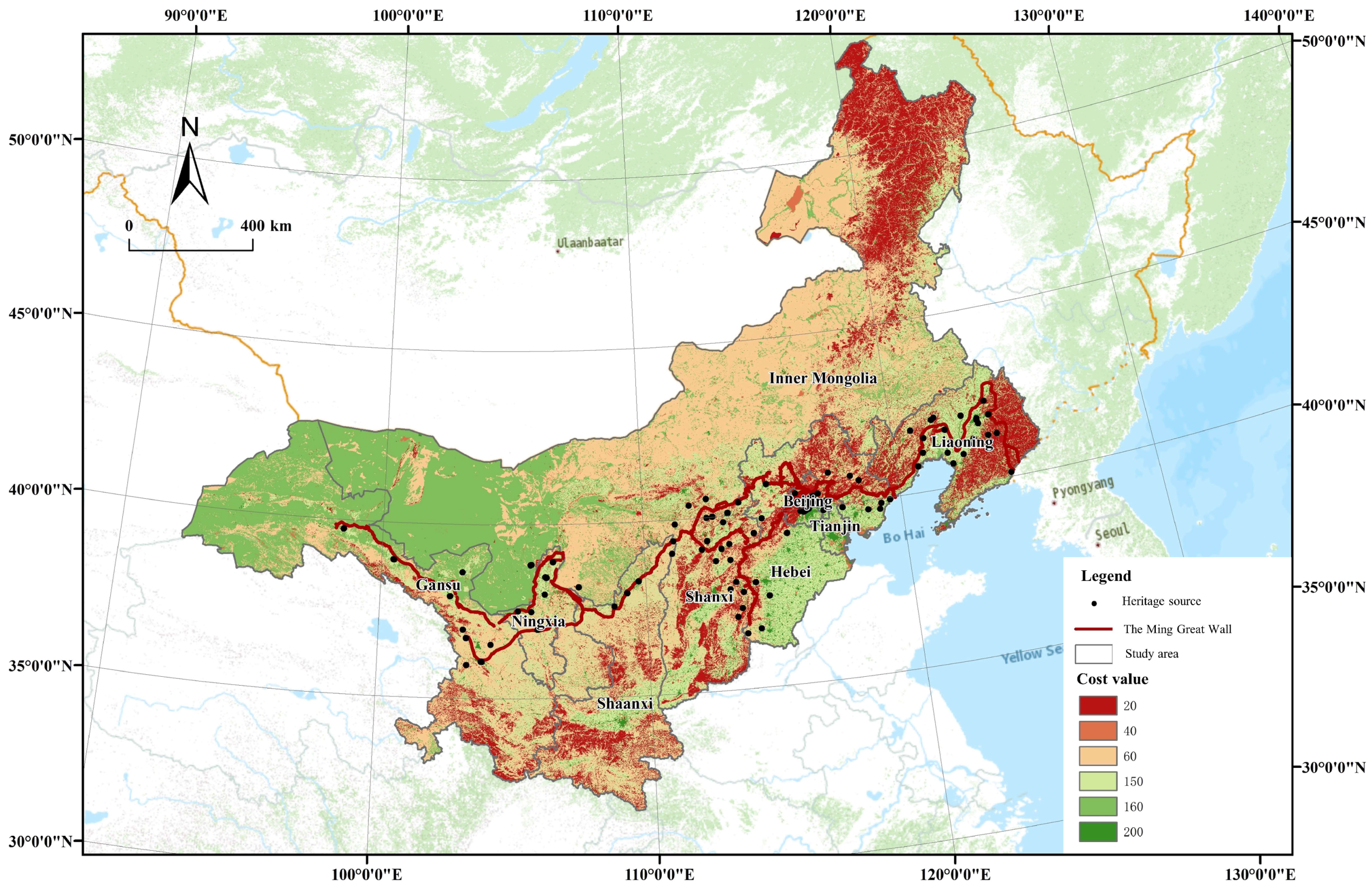
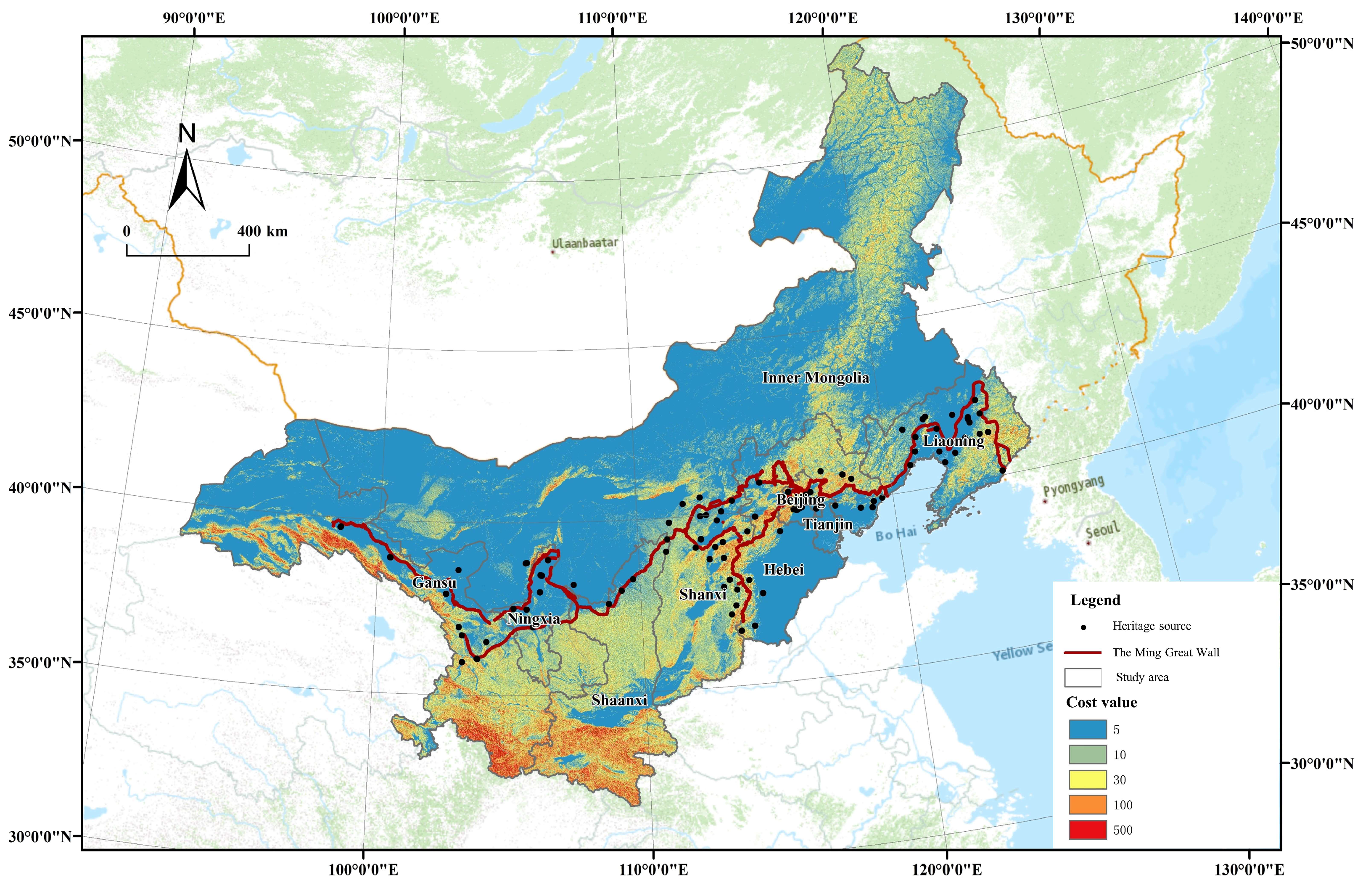
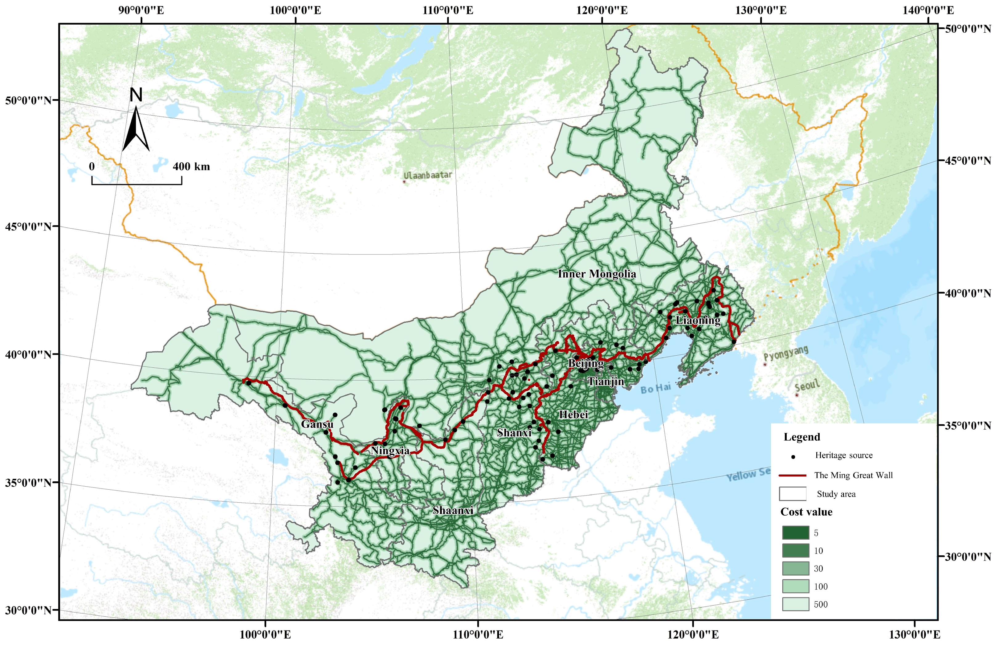
3.2.1. Determination of Resistance Factor

Resistance values reflect the difficulty of different sources passing through the same cell. Different resistance assignment values have an important impact on the construction of potential heritage corridors. Many studies have focused on ecological sensitivity, recreation suitability, and landscape suitability. Combined with the ecological and cultural environment characteristics along the Ming Great Wall, referring to relevant studies, elevation, terrain, land use category, etc., were selected as resistance factors, and the environmental base analysis of the suitable range of heritage corridors was carried out.
The Ming Great Wall is located in a region with complex and fragile natural ecological environments. The ICH is deeply influenced by various natural factors such as terrain and slope, and its distribution, form and pattern show diversity and complexity. The regional elevation mainly affects the climatic environment and living conditions of ICH. The higher the elevation, the greater the resistance to access and the lower its suitability [46]. The terrain slope reflects the slope of the surface, and a place with a large slope is generally not conducive to the survival and development of ICH. The greater the slope, the greater the resistance value and the lower its suitability [25]. The emphasis of the concept of the heritage corridor is to attach equal importance to ecological environment protection and economic development, so regional economic development and recreational utilization should also be important factors in the construction of heritage corridors. Land use types are closely related to both. River and forest land are the key parts of the ecological basement, so the resistance values of water and forest land are low. The resistance values of landscape elements that do not have heritage protection value but are compatible with heritage experience and leisure activities, such as urban green space, gardens, grassland, and cultivated land, are in the middle [47]. Urban construction land has low compatibility with heritage experience and leisure activities and causes certain obstacles to people’s crossing. It is unsuitable for heritage corridors as a component element, so the resistance value is the highest. Road traffic mainly affects ICH recreational activities and development convenience. The closer the ICH is to the main road, the smaller the traffic resistance and the higher the suitability [48]. The river system mainly affects the recreation comfort of ICH and the value potential of economic development. The closer it is to the main river, the higher its recreation and economic value, the smaller its resistance value, and the higher its overall suitability [48]. In summary, this study proposed that the main resistance factors for assessing the suitability of ICH along the Ming Great Wall were the land use type, elevation, slope, road system, and river system.

3.2.2. Resistance Value Classification and Weight Assignment

The resistance factors of the heritage corridors along the Ming Great Wall include the land use type, elevation, slope, road system, and river system. The relevant resistance factors were classified with relevant literature research and regional environmental characteristics along the Ming Great Wall. The hierarchical structure model was constructed by using AHP. The target layer corresponds to the comprehensive suitability of the heritage corridors of the Ming Great Wall, and the criterion layer corresponds to the land use type, elevation, slope, road system, and river system. The judgment matrix was constructed by AHP, and the maximum eigenvalue and eigenvector of the judgment matrix were calculated by the sum–product method. The total consistency test value of CR* = 0.025 is less than 0.1, which means that the judgment matrix of this study meets the consistency test. Finally, the specific weights of each factor and the evaluated elements were obtained (Table 2).
Depending on ArcGIS10.2, various resistance factors were classified to obtain a visual resistance distribution surface. From the perspective of land use type (Figure 6), areas with low resistance, such as forest land and water area, are linearly distributed from northeast to southwest and are mainly located in northeast Inner Mongolia, east Liaoning, and north Beijing. Unused land, grassland, and cultivated land, with moderate resistance values, are widely distributed in Inner Mongolia, Gansu, Ningxia, Shaanxi, and other regions. Construction land, with a high resistance value, is mainly distributed in Beijing, Tianjin, and other developed areas. Along the Ming Great Wall, there were 207 items (94.09%) of ICH in construction land, while there were 1 (0.45%), 3 (1.36%), 2 (0.91%), and 7 (3.18%) ICHs located in forest land, water areas, grassland, and cultivated land, respectively. There was no distribution of ICH points on unused land.
From the perspective of elevation (Figure 7), the areas along the Ming Great Wall show a characteristic distribution that is high in the west and low in the east. Beijing, Tianjin, Hebei, Liaoning, and other areas have low elevations and small resistance values. Gansu, western Inner Mongolia, Ningxia, and other regions are at higher altitudes, and the resistance value of building heritage corridors is also larger. The number of ICH sites along the Ming Great Wall is 119 (54.09%) below 600 m. At 600–1100 m, 1100–1500 m, and 1500–2300 m, the distribution is relatively uniform, which is 37 (16.82%), 37 (16.82%), and 25 (11.36%), respectively. The number of ICH sites at high altitude areas is low. There were two (0.91%) ICH points between 2300 and 3300 m, while there was no distribution of ICH points above 3300 m.
In terms of slope (Figure 8), the areas with large slopes are mainly distributed in the Qilian Mountains in western Gansu, with large resistance values, while Beijing, Tianjin, Hebei, and other areas have flat terrain. In the areas along the Ming Great Wall, ICH is only distributed on slopes of 0–3° and 3–8°, with 209 (95%) and 11 (5%) ICH sites, respectively. It can be seen that the variable geomorphic structure along the Ming Great Wall provides the basis for the diversity in ICH.
From the perspective of the river system (Figure 9), the area along the Ming Great Wall has the most developed river system, including the Yellow River system and other river systems. Rivers are widely distributed in the south of the area along the Ming Great Wall. ICH is mainly distributed in the areas adjacent to rivers, with 32 (14.55%), 46 (20.91%), and 53 (24.09) ICH sites within 1000 m, 1000–2000 m, and 2000–5000 m, respectively. There are also some ICHs at the far ends of rivers. There are 34 (15.43%) and 55 (25%) sites in areas within 5000–10,000 m and further than 10,000 m, respectively.
Expressways, national roads, and provincial roads were formed into a density map of the highway network and superimposed with ICH (Figure 10). It can be seen that the traffic network in Beijing-Tianjin-Hebei and other regions is dense, while the traffic network in Inner Mongolia, Gansu, and other regions is sparse. The area within 1000 m of roads has the largest distribution of ICH, with 150 (68.18%). There are 45 (20.45%), 15 (6.82%), and 10 (4.55%) in the distances from roads of 1000–2000 m, 2000–5000 m, and 5000–10,000 m, respectively. In addition, there is no ICH distribution in the area more than 10,000 m away from roads. It can be found that the intangible heritage points are sparsely distributed in the high-value area of highway network density, with the densest distribution in the median-value area and a less dense distribution in the low-value area.

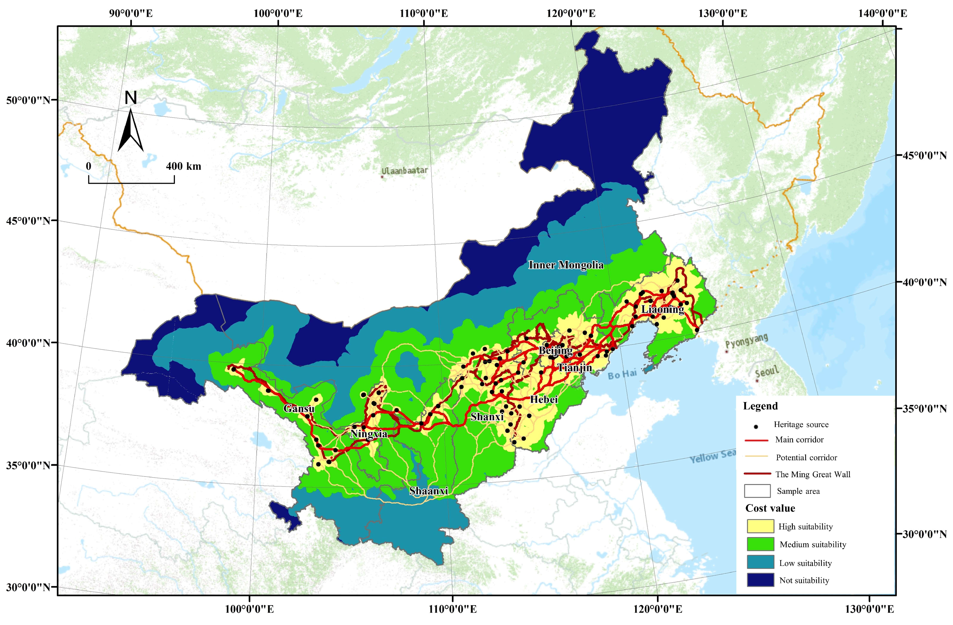
3.2.3. Suitability Partitioning

Based on the weight values of the resistance factors in Table 2 and the weighted superposition of various resistance surfaces by ArcGIS10.2, the comprehensive resistance surface analysis diagram of ICH corridors along the Ming Great Wall was obtained (Figure 11). The comprehensive resistance value increases from east to west. The resistance value in the west is generally high, while the resistance value in the east, especially in Beijing and Liaoning, is low, which is suitable for constructing heritage corridors. By using the cost distance tool of ArcGIS10.2 for calculation, the suitability evaluation results of the heritage corridors can be further divided into four areas: high, medium, low, and unsuitable (Figure 12). In general, the distribution trend of suitability is “high in the east and low in the west”. The high-suitability areas are mainly concentrated in the Beijing-Tianjin-Hebei and Liaoning regions, while the low-suitability areas are concentrated in Gansu, Ningxia, and northern Inner Mongolia. This is the result of the combination of the gathering of ICH and the natural and social environment. The areas with high suitability are distributed in the vicinity of traffic trunk lines, rivers, forestland, grassland, arable land, etc., while the areas with low suitability are mainly mountains and hills with weak traffic.

3.2.4. Potential Heritage Corridor Network Construction and Optimization

Heritage corridors are the connection channel of various ICHs and the link between ICH protection and ecological planning. In this study, the model builder tool in ArcGIS10.2 was used to set model parameters; the heritage source, comprehensive resistance surface, cost distance, and path distance tools were taken as component elements; and all the shortest paths between each ICH were calculated, excluding repeated and partial cross paths. A total of 220 potential heritage corridors were identified and extracted. The Ming Great Wall, the developed traffic trunk line, and the interwoven river network are the important factors affecting the direction of heritage corridors. The study fully considered the integrity and connectivity, combined with the actual layout of the Ming Great Wall, traffic network, and water network, selected and optimized the heritage corridor network through a topological structure analysis, and screened out the main heritage corridors and several secondary heritage corridors to form the heritage corridor network (Figure 13).

3.2.5. Scope Definition and Regional Division of Heritage Corridors

The width of corridors plays an important role in planning heritage corridors, which can directly determine the comprehensiveness and efficiency of ICH protection. Due to the complex elements and diverse functions of heritage corridors, there has been no authoritative conclusion on the reasonable width of corridors. The research refers to Li et al. [49] and takes the linear relationship between ICH and corridors as an important basis for determining the width range of heritage corridors. The spatial linear analysis results of ICH and heritage corridors along the Ming Great Wall (Figure 14) show that when the distance between ICH and corridors is within 8 km, 52.27% of heritage sources are covered; within 30 km, 71.36% of the heritage sources are covered; and within 40 km, 78.64% of heritage sources are covered. Therefore, the buffer analysis was carried out with the radii of 8 km, 30 km, and 40 km. According to the spatial relationship between heritage sources and corridors, the heritage area was divided into core, buffer, and edge areas. The width of the core area was 0–8 km, covering 52.27% of the heritage sources. The buffer zone width was 8–30 km, containing scattered heritage sources. The marginal area was 30–40 km wide and contained very few heritage sources.

4. Discussion

4.1. The Internal Logic of the Spatial Pattern of ICH

Human activities and geographical environments affect and restrict each other. The essence of the development of human society is the development of the relationship between man and land, and there is an interactive development law between man and land. ICH is the crystallization of the interaction in regional man–land relationships [50]. This point of view reveals the nature of ICH. The spatial differentiation of ICH along the Ming Great Wall is the result of the comprehensive influences of the natural environment and social environment. As Cheng (2013) said, ICH is essentially a living culture, a continuation of the memory fragments of historical context after going through the vicissitudes of life. Therefore, it is inevitable to spread and integrate with each other from the very beginning of its formation. ICH is rooted in the soil where human beings live, presenting regional and temporal differences due to the different natural and social environments, and political, economic, and psychological conditions of human beings [51].
From the perspective of land use type, construction land includes not only urban land but also traditional rural settlements, which are the basic unit of human life. As the creator of ICH and the bearer of protection and development, people will inevitably affect the distribution of ICH, so construction land is the dense area of ICH. Correspondingly, unused land means it is difficult for people to produce and live on it, and ICH is difficult to create, develop, and inherit in this region. From the perspective of topography and geomorphology, the areas along the Ming Great Wall run through the first to the third steps of China’s terrain, showing a general trend of high in the west and low in the east. There are rich geomorphic environments along the Great Wall, such as plateau snow mountains, deserts, canyon plains, lakes, and hills, with great regional terrain differences. Among them, the eastern part of the Ming Great Wall in Liaoning, Beijing, Hebei, and Shanxi is mostly hilly plains and basins with flat and open terrain, which is conducive to production and cultural exchange and promotes the formation and dissemination of ICH [52]. Therefore, the high-density distribution area of ICH along the Ming Great Wall is located in the North China Plain and the Northeast Plain. From the perspective of river systems, river systems not only provide fertile land for the continuation of human life but also play the role of communication and connection, providing places and channels for cultural formation and interaction and accelerating the integration and competition between different cultures [53]. Based on this characteristic, people have always followed the principle of settlement by neighboring water, and rivers are often regarded as the birthplace of human civilization. Therefore, river systems with abundant water supply are often surrounded by areas with dense distributions of ICH. In the area along the Ming Great Wall, ICH is widely distributed in the Yellow River basin, Yongding River system, and Liaohe River system. From the perspective of transportation, transportation is an important channel to spread ICH, which is conducive to promoting the formation and development of ICH. Relatively convenient transportation can create convenient conditions for the influx and prosperity of culture. At the same time, more people have the opportunity to understand and experience ICH and enhance the vitality of ICH. To some extent, the relatively backwards transportation network hinders the evolution of folk culture to modern social culture, but it also precisely keeps some regional ICH away from the impact of modern commercialization to survive in the new era [54]. Because of this, the ICH along the Ming Great Wall is densely distributed in the first-level buffer (within 1000 m) and second-level buffer (1000–2000 m) of the road. In this moderate distance area, it can not only guarantee the production and living needs and moderate contact with modern society, but it can also delay the village modernization process and external impact. This phenomenon coincides with the view of cultural ecology theory. “Cultural ecology” is a composite structure of “nature-economy-society” composed of three levels: the natural environment, economic environment, and social organization environment. Therefore, the existence of differences in the natural, economic, and social environments in different regions will lead to differences in cultural ecology among regions, thus affecting the distribution of regional ICH [55].

4.2. Protection Strategies of Heritage Corridors from a Regional Perspective

4.2.1. Macrolevel: Determining the Overall Structure of the Heritage Corridors

The fundamental problem of heritage corridor construction is “where”. Landscape elements, the spatial relationship and distance of ICH, and the surrounding landscape conditions are all important factors affecting the connection degree of heritage corridors. Through the suitability analysis, the spatial position of the corridors was studied and discussed. There are obvious differences in the suitability of the ICH along the Ming Great Wall. It is necessary to adopt different development strategies to inherit the ICH. According to the results of the comprehensive suitability analysis and the distribution characteristics of ICH along the Ming Great Wall, the main heritage corridors of ICH sites can be divided into a core area (8 km), a buffer area (30 km), and an edge area (40 km), within which 78.64% of heritage sources (173) can be connected. The rest of the ICH points (47) can be connected by secondary corridors in series. At the regional level, the whole area of the ICH corridor network is protected and utilized, and the greenway system, interpretation system, and traffic system are constructed.
In terms of green corridors, the green corridors are rich in regional ecological and natural elements. They are not only the main part of the protection and utilization of heritage corridors but also the greenways for rest, sightseeing, and protection as well as the historical environmental channels for inheritance and the exchange of heritage resources [54]. Therefore, the construction of appropriate green corridors can, on one hand, organically unify the ecological nature and ICH resources in the heritage corridors along the Ming Great Wall and realize sustainable utilization. On the other hand, the green corridors can better show the profound cultural connotation of the ICH along the Ming Great Wall. From the analysis of land use types, it can be seen that there are various kinds of natural greenways along the Ming Great Wall, including abundant woodland and grassland, and many of these land types have been developed into forest parks, scenic spots, and nature reserves, providing continuous green corridor resources for the heritage corridor from a macroperspective.
In terms of the interpretation system, the interpretation system of heritage corridors is one of the main elements of the construction of heritage corridors, which integrates, protects, and activates heritage resources with similar historical and cultural connotations in accordance with the integrity principle. A good interpretation system can make it easier for the public to receive the cultural information contained in heritage corridors, deepen the understanding of the value, function, and cultural connotation of heritage resources, and enhance the public’s sense of experience and responsibility for protecting heritage resources [56]. The ICH along the Ming Great Wall is rich in composition, involving ten categories, with regional diversity, authenticity, and other distinctive characteristics and outstanding value. The ICH in the corridors carries the collective memory of the cultural development history of all ethnic groups along the Ming Great Wall. The cultural characteristics of each region in the corridor are different, so the types of ICH contained in the corridors are also different. The standard deviation ellipse was used to analyze the development direction of all kinds of ICH and to construct “sub-corridors” for all kinds of ICH. On one hand, the ICH points are more carefully contained, and on the other hand, the diversity and typicality of the whole corridors are reflected. Taking the folk art category as an example, the distribution of folk art ICH in the corridors tends to the northeast direction, while the folk art in Ningxia and Gansu is mostly on the verge of extinction and gradually declining. Therefore, “Folk art corridors” including Lanzhou Guzi, Ningxia Xiaoqu, Yulin Xiaoqu, and Northeast Dagu should be constructed, with distinct characteristics from the plateau style to northeast enthusiasm.
In terms of the transportation system, the heritage corridors along the Ming Great Wall span nine provinces: Liaoning, Hebei, Tianjin, Beijing, Shanxi, Inner Mongolia, Shaanxi, Ningxia, and Gansu. The smooth connection of ICH resources along the Ming Great Wall requires reasonable planning of the transportation system in the corridors to improve the accessibility of transportation between various areas along the Ming Great Wall. The transportation system of corridors can be carried out on the basis of the existing railway, high-speed national roads, and provincial roads, such as the Beijing-Xinjiang expressway and the Dandong-Altay highway, to strengthen the connection between the regions. At the same time, in the era of high-speed railways, we should give full play to the role of high-speed railways in the region, improve the planning and construction of intercity railways, establish seamless traffic station lines between airports, rail stations, and coach passenger stations, and speed up the construction of township transportation lines to enhance the accessibility of the heritage corridors of the Ming Great Wall. In the corridor internal traffic system, sightseeing trails, bicycle paths, and other slow traffic systems can be built. Slow traffic lines should be combined with heritage site resources and an interpretation system to increase the value of slow traffic system leisure, sightseeing, and the historical and cultural experience and enhance visitors’ sense of experience [57].
In addition, different levels of protection areas should also adopt different protection strategies. The core protected area of heritage corridors is mainly composed of the Ming Great Wall, the adjacent green corridors, and a large number of ICHs along the route, most of which are closely related to the Ming Great Wall. To protect the ICH in this region, we should not only protect the ICH itself but also protect the material environment on which it depends. The material and ICH should be effectively integrated with the construction of public infrastructure, and the protection and inheritance of local cultural characteristics such as folk customs and township rules and regulations should be strengthened, which should be adapted to modern culture and living environments. The buffer zone of heritage corridors mainly includes the regional green corridors and scattered heritage sites along the corridors. On the basis of ICH protection and habitat restoration, the region should strengthen its connection with the core protection area, carry out appropriate construction activities and resource development, and achieve the self-renewal and sustainable development of ICH resources by generating income through tourism. In the marginal area of the heritage corridors, there are very few heritage sites. This area should mainly carry out reasonable planning and control, strengthen the protection of ICH inheritors, limit the development and construction activities that seriously damage ICH, and prevent it from being “submerged” by modernization.

4.2.2. Mesolevel: Formation of Protection Clusters

An ICH point is the core of heritage protection. A single ICH point co-exists with the surrounding environment and its native culture, historical connotation, and national spirit. The heritage corridors mean to tell local stories together to the fragmented and distributed ICH points [58]. In this study, the concept of clusters is introduced to protect against different types of ICH. The ICH clusters that are culturally related, with similar characteristics and regions due to a common mechanism in history are called ICH clusters. The cluster is divided by the kernel density estimation, that is, by exploring the occurrence probability of ICH elements in space, and the density or sparsity of elements is visualized to reflect the aggregation degree of points. Through kernel density analysis, the relatively aggregated ICH was screened out, and each agglomeration area was the important cluster of corridors and the “growth pole” of ICH protection along the Ming Great Wall. It can be found that ICH shows a strong regional concentration, that is, there are three different density concentration areas in Beijing, Liaoning, and Ningxia. They are the Beijing-Tianjin-Hebei ICH cluster, Liaoning ICH cluster, and Ningxia-Gansu ICH cluster (Figure 15).
Each region in the node should not be restricted by regional restrictions, and the core area should be used to drive the edge area, promote communication between groups, and give full play to the attraction and diffusion effects of the “growth pole”. Pay attention to the “people” element, give full play to the strength of the people, from the inheritors of ICH to community residents, and let the ICH tell the local story completely. The Beijing-Tianjin-Hebei ICH cluster is mainly embodied in the Great Wall culture and folk culture. Guided by the cultural connotation, the cluster mainly relies on historical and cultural resources such as the Great Wall and military fortress as well as folk performances such as Peking Opera and Yangko dance, and forms a greenway system, interpretation system, and tour trail system based on the Great Wall and folk recreation. The ICH cluster of Ningxia and Gansu is mainly embodied in the culture of the Great Wall and the Yellow River, followed by Dunhuang culture, Buddhist culture, and ancestor culture. Guided by the cultural connotation, the cluster mainly relies on historical and cultural resources such as the Great Wall, the Yellow River, military barrier villages, related military facilities, and key historical roads, forming the Great Wall, Yellow River tour, and Dunhuang culture experiences and other major greenway, interpretation, and tour trail systems. The Liaoning ICH cluster is mainly reflected in the Great Wall culture, literary and artistic culture, military culture, etc. Guided by the cultural connotation, this cluster mainly relies on historical and cultural resources such as the Great Wall and the military fortress and related military facilities as well as artistic performances such as duets, Liao opera, and stilts. The greenway system, interpretation system, and walking path system are formed mainly for the Great Wall, military fortress tour, and literary and artistic appreciation.

5. Conclusions

The Ming Great Wall is an important world cultural heritage, carrying rich historical and cultural information. It is a chain cultural group formed by material heritage and ICH. However, the overall research on the ICH of the Ming Great Wall is obviously insufficient. It is necessary to put forward a protection strategy for the ICH of the Ming Great Wall from the perspective of heritage corridors and on the premise of holistic cognition. Guided by the concept of heritage corridors, this study took the ICH along the Ming Great Wall as the research object, divided the ICH points as important nodes of the corridors with the help of kernel density estimation, and determined the extension direction by standard deviation ellipse analysis. Combined with the suitability analysis, the spatial location of the corridors was further explored. With the method of MCR, multifactor spatial superposition was carried out to construct heritage corridors with the ICH of the Ming Great Wall as the protection object. On this basis, the regional protection strategy of ICH was further discussed.
The contributions of this study to the literature are as follows: First, the existing studies on the Great Wall mostly focus on the analysis and evaluation of the material cultural heritage and rarely discuss ICH and its material dependency. Based on the theory of heritage corridors, this study distinguishes the ICH along the Ming Great Wall from the general ICH projects and regards it as “linear ICH”, clarifies its characteristics of spatial continuity, overall value, and multidimensional development, closely combines the research of ICH and heritage corridors, and discusses the relationship between ICH and the natural environment and humanistic environment. Second, because ICH covers a wide range of fields and has complex formation and development factors, the research on the spatial distribution characteristics of ICH has significant practical significance for exploring the protection and development mode of ICH. Through the analytical thinking of “type integration + spatial pattern”, this research discusses the spatial pattern and its internal logic of ICH. This analytical method is helpful to make full use of and maintain the cultural, social, scientific, and economic values of ICH, integrate regional cultural heritage resources, and improve the competitiveness and influence of regional cultural industries. Third, the existing research on ICH mostly involves disciplines such as the nationality, anthropology, and history, and there are many single-discipline decentralized local studies. However, due to the complex factors for the formation and development of ICH, many factors such as the natural environment, history, culture, and social economy need to be considered. Based on the disciplinary perspective of geography and remote sensing science, this study conducted a comprehensive and systematic study on the ICH along the Ming Great Wall by means of mathematical statistics and spatial analysis, which is conducive to communication and penetration between different disciplines.
The findings of this study have several practical implications for ICH development. First, in terms of the spatial pattern of evolution, the ICH along the Ming Great Wall has formed “three cores and one belt”, with high-density core areas in Beijing and Liaoning and sub-core areas in northern Ningxia and southwestern Inner Mongolia. This is the result of the trinity of natural, economic and social environments. Therefore, the inheritance and protection of ICH should not only focus on the inheritors of ICH but also on the physical sites and natural environment where ICH exists. Second, all kinds of ICH generally show a southwest to northeast distribution pattern, among which the folk art ICH is particularly obvious, and the center of gravity of the other kinds of ICH is also different. The differentiated spatial distribution pattern is conducive to establishing multiple interpretation systems and realizing differentiated development of ICH. “Sub-corridors” can be constructed according to various kinds of ICHs, and then the ICH points can be carefully accommodated, reflecting the diversity and typicality of the whole corridor. Third, the paper discusses the appropriate development mode of the heritage corridors of the Ming Great Wall from the macrolevel and the microlevel and then proposes the promotion path of constructing the heritage corridors of the Ming Great Wall to promote the formation of the “trinity” of people, culture, and the environment and break through the single protection mode of ICH at the present stage. This is in line with the latest international trend of thought in heritage protection.
Although this study measured and analyzed the spatial structure of the ICH along the Ming Great Wall and constructed the heritage corridors, there are still some limitations: (1) There are many influencing factors involved in the construction of heritage corridors. In this study, only elevation, slope, river, road, and land use type were selected as resistance factors, and economic status and heritage source classification were not considered. Additionally, due to the lack of a unified resistance factor assignment standard, the study referred to related research and combined it with a questionnaire survey to determine the resistance value. This method is subjective to a certain extent, which may affect the scientificity of the research results. It is necessary to appropriately add resistance factors in subsequent studies and to determine the resistance value in a more scientific way. (2) ICH, as the national wisdom and civilization crystallization of human civilization, has witnessed the continuous development and inheritance of human society. Under the influence of different regional environments, it represents different temporal, spatial, and cultural characteristics and has a certain internal logic. This study only discusses the ICH from the spatial dimension, without placing it in the context of the times, excavating its historical context and cultural origin, which is not conducive to endowing the ICH with a deeper humanistic significance.

Author Contributions

Conceptualization, Z.M.; methodology, F.L. and X.Z.; software, F.L. and X.Z.; validation, F.L.; formal analysis, F.L.; investigation, F.L., X.Z., Z.M. and Y.Z.; data curation, F.L. and X.Z.; writing—original draft preparation, F.L.; writing—review and editing, F.L. and X.Z.; visualization, F.L.; supervision, F.L. and Z.M.; project administration, F.L. and Z.M.; funding acquisition, F.L and Z.M. All authors have read and agreed to the published version of the manuscript.

Funding

This research was funded by the 2021 Tianjin Graduate Research Innovation Project, China (grant number 2021YJSS016); the National Social Science Foundation of China (grant number 21AZD055); and the National Culture and Tourism Science and Technology Innovation Project of China (grant number 2021-97).

Institutional Review Board Statement

Not applicable.

Data Availability Statement

Not applicable.

Conflicts of Interest

The authors declare no conflict of interest.

References

  1. Steward, J.H. Theory of Culture Change: The Methodology of Multilinear Evolution; University of Illinois Press: Urbana, IL, USA, 1979. [Google Scholar]
  2. Jiang, J. On the theoretical development and new framework of cultural ecology. Hum. Geogr. 2005, 119–125. (In Chinese) [Google Scholar] [CrossRef]
  3. The United Nations Educational, Scientific and Cultural Organization. Text of the Convention for the Safeguarding of the Intangible Cultural Heritage. Available online: https://ich.unesco.org/en/convention (accessed on 27 August 2022).
  4. Li, L.; Yang, H. Spatial ecological interpretation and practical application of intangible cultural heritage. Urban Dev. Stud. 2015, 22, 38–42. (In Chinese) [Google Scholar]
  5. Cominelli, F.; Greffe, X. Intangible cultural heritage: Safeguarding for creativity. City Cult. Soc. 2012, 3, 245–250. [Google Scholar] [CrossRef]
  6. York, Q.Y.; Yan, L.; Ben, H.Y. My life matters here: Assessing the adjusted identity of domestic migrant workers at intangible cultural heritage tourism businesses in China. Tour. Manag. Perspect. 2021, 39, 100856. [Google Scholar] [CrossRef]
  7. Lin, F. The dynamic mechanism of the construction of cultural and ecological reserves: A discussion from the perspective of “space production”. J. Minzu Univ. China Philos. Soc. Sci. Ed. 2021, 114–122. (In Chinese) [Google Scholar]
  8. Yang, C.; Lin, H.; Han, C. Analysis of international tourist arrivals in China: The role of World Heritage Sites. Tour. Manag. 2010, 31, 827–837. [Google Scholar] [CrossRef]
  9. Yuan, C.; Gan, L.; Zhuo, H. Coupling Mechanisms and Development Patterns of Revitalizing Intangible Cultural Heritage by Integrating Cultural Tourism: The Case of Hunan Province, China. Sustainability 2022, 14, 6994. [Google Scholar] [CrossRef]
  10. Garrod, B.; Fyall, A. Managing heritage tourism. Ann. Tour. Res. 2000, 27, 682–708. [Google Scholar] [CrossRef]
  11. Ji, X.; Shao, L. The Application of Landscape Infrastructure Approaches in the Planning of Heritage Corridor Supporting System. Procedia Eng. 2017, 198, 1123–1127. [Google Scholar] [CrossRef]
  12. Chen, Y.; Dang, A.; Peng, X. Building a Cultural Heritage Corridor Based on Geodesign Theory and Methodology. J. Urban Manag. 2014, 3, 97–112. [Google Scholar] [CrossRef]
  13. Wang, Z.; Sun, P. Heritage Corridor: A new method of heritage protection. Chin. Landsc. Arch. 2001, 86–89. (In Chinese) [Google Scholar]
  14. Yang, X.; Chen, J. Research on the construction of linear intangible cultural heritage corridor in the Silk Road Economic Belt. J. Arid Land Resour. Environ. 2021, 35, 202–209. (In Chinese) [Google Scholar] [CrossRef]
  15. Byrne, D. Heritage corridors: Transnational flows and the built environment of migration. J. Ethn. Migr. Stud. 2016, 42, 2360–2378. [Google Scholar] [CrossRef]
  16. Holladay, P.; Skibins, J.; Zach, F.; Arze, M. Exploratory Social Network Analysis of Stakeholder Organizations Along the Illinois and Michigan Canal National Heritage Corridor. J. Park Recreat. Adm. 2017, 35, 37–48. [Google Scholar] [CrossRef]
  17. Mar, L.; Rafael, M.; Rita, R.; Daniel, P. An Interdisciplinary Methodology for the Characterization and Visualization of the Heritage of Roadway Corridors. Geogr. Rev. 2016, 106, 489–515. (In Chinese) [Google Scholar] [CrossRef]
  18. Liang, J.; He, X.; Zeng, G.; Zhong, M.; Gao, X.; Li, X.; Li, X.; Wu, H.; Feng, C.; Xing, W.; et al. Integrating priority areas and ecological corridors into national network for conservation planning in China. Sci. Total Environ. 2018, 626, 22–29. [Google Scholar] [CrossRef] [PubMed]
  19. Hong, W.; Guo, R.; Su, M.; Tang, H.; Chen, L.; Hu, W. Sensitivity evaluation and land-use control of urban ecological corridors: A case study of Shenzhen, China. Land Use Policy 2017, 62, 316–325. [Google Scholar] [CrossRef]
  20. LaPoint, S.; Gallery, P.; Wikelski, M.; Kays, R. Animal behavior, cost-based corridor models, and real corridors. Landsc. Ecol. 2013, 28, 1615–1630. [Google Scholar] [CrossRef]
  21. Ye, Y.; Xu, L. Ecological Corridors Analysis Based on MSPA and MCR Model—A Case Study of the Tomur World Natural Heritage Region. Sustainability 2020, 12, 959. [Google Scholar] [CrossRef]
  22. Zhang, D.; Feng, T.; Zhang, J. Discussion on the construction of heritage corridors along Weihe River system in Xi’an Metropolitan Area. Chin. Landsc. Arch. 2016, 32, 52–56. (In Chinese) [Google Scholar]
  23. Dos Santos, A.R.; Araújo, E.F.; Barros, Q.S.; Fernandes, M.M.; de Moura Fernandes, M.R.; Moreira, T.R.; de Souza, K.B.; da Silva, E.F.; Silva, J.P.M.; Santos, J.S.; et al. Fuzzy concept applied in determining potential forest fragments for deployment of a network of ecological corridors in the Brazilian Atlantic Forest. Ecol. Indic. 2020, 115, 106423. [Google Scholar] [CrossRef]
  24. Morandi, D.T.; França, L.a.d.J.; Menezes, E.S.; Machado, E.L.M.; da Silva, M.D.; Mucida, D.P. Delimitation of ecological corridors between conservation units in the Brazilian Cerrado using a GIS and AHP approach. Ecol. Indic. 2020, 115, 106440. [Google Scholar] [CrossRef]
  25. Peng, J.; Zhao, H.; Liu, Y. Urban ecological corridors construction: A review. Acta Ecol. Sin. 2017, 37, 23–30. [Google Scholar] [CrossRef]
  26. Liu, H.; Wang, Y. Construction and evaluation of traditional village cultural landscape safety corridor: A case study of Anyi ancient village in Nanchang. J. Nanchang Inst. Technol. 2019, 38, 50–59. (In Chinese) [Google Scholar]
  27. Jin, C.; Lu, Y. The types division and corridors construction of beautiful village construction in county level: A case study of Deqing, Zhejiang Province. Resour. Environ. Yangtze Basin 2015, 24, 18–25. (In Chinese) [Google Scholar] [CrossRef]
  28. Ngo, V.D.; Frank, L.D.; Bigazzi, A.Y. Effects of new urban greenways on transportation energy use and greenhouse gas emissions: A longitudinal study from Vancouver, Canada. Transp. Res. Part D Transp. Environ. 2018, 62, 715–725. [Google Scholar] [CrossRef]
  29. Gao, Y.; Mu, H.; Zhang, Y.; Tian, Y.; Tang, D.; Li, X. Research on construction path optimization of urban-scale green network system based on MSPA analysis method: Taking Zhaoyuan City as an example. Acta Ecol. Sin. 2016, 39, 7547–7556. (In Chinese) [Google Scholar] [CrossRef]
  30. Liu, Z.; Lin, Y.; De Meulder, B.; Wang, S. Heterogeneous landscapes of urban greenways in Shenzhen: Traffic impact, corridor width and land use. Urban For. Urban Green. 2020, 55, 126785. [Google Scholar] [CrossRef]
  31. Shan, N.; Zhou, K.; Pan, Y.; Tang, F. Research advances in design methods of biodiversity conservation corridors. Acta. Ecol. Sin. 2018, 39, 411–420. (In Chinese) [Google Scholar] [CrossRef]
  32. Severo, M. European cultural routes: Building a multi-actor approach. Mus. Int. 2017, 69, 136–145. [Google Scholar] [CrossRef]
  33. Yu, K.; Xi, X.; Li, D.; Li, H.; Liu, K. Construction of national linear cultural heritage network in China. Hum. Geogr. 2009, 24, 11–16. (In Chinese) [Google Scholar]
  34. Liu, J. New ideas for cultural heritage protection: A preliminary study on the “Trinity” protection mode of linear cultural heritage. Southeast Cult. 2011, 26, 19–24. (In Chinese) [Google Scholar]
  35. Feng, X.; Chen, S. Spatial pattern construction of linear cultural heritage: A case study of Datong section of the Great Wall in Ming Dynasty. Chin. Landsc. Arch. 2019, 26, 31–37. (In Chinese) [Google Scholar]
  36. Xu, L.; Zhang, Y.; Li, Y. Ming Great Wall defensive system of cultural heritage value evaluation research. J. Beijing Union Univ. Hum. Soc. Sci. 2018, 16, 90–99. (In Chinese) [Google Scholar]
  37. Cao, X.; Zhou, Q. Regional protection and utilization patterns of military fortressalong the Great Wall of Ming dynasty in Shanxi Province. Urban Dev. Stud. 2016, 23, 32–38. (In Chinese) [Google Scholar]
  38. Zhang, Y.; Xu, L.; Li, Y.; He, J. Construction and application of Ming Great Wall cultural heritage database from the perspective of spatial humanity. Tradit. Chin. Arch. Gard. 2019, 78–83, 94. (In Chinese) [Google Scholar]
  39. Yang, S.; Zhang, P.; Zhang, Y. Research on historical geographic Information System Architecture of Ming-Cheng Military Settlement. Archit. J. 2012, 53–57. (In Chinese) [Google Scholar]
  40. Luo, G.; Wang, B.; Luo, D.; Wei, C. Spatial Agglomeration Characteristics of Rural Settlements in Poor Mountainous Areas of Southwest China. Sustainability 2020, 12, 1818. [Google Scholar] [CrossRef]
  41. Wang, H.; He, J.; Aziz, N.; Wang, Y. Spatial Distribution and Driving Forces of the Vegetable Industry in China. Land 2022, 11, 981. [Google Scholar] [CrossRef]
  42. Macharis, C.; Springael, J.; De Brucker, K.; Verbeke, A. PROMETHEE and AHP: The design of operational synergies in multicriteria analysis: Strengthening PROMETHEE with ideas of AHP. Eur. J. Oper. Res. 2004, 153, 307–317. [Google Scholar] [CrossRef]
  43. Chan, F.T.S.; Kumar, N. Global supplier development considering risk factors using fuzzy extended AHP-based approach. Omega 2007, 35, 417–431. [Google Scholar] [CrossRef]
  44. Lookingbill, T.R.; Elmore, A.J.; Engelhardt, K.A.; Churchill, J.B.; Gates, J.E.; Johnson, J.B. Influence of wetland networks on bat activity in mixed-use landscapes. Biol. Conserv. 2010, 143, 973–983. (In Chinese) [Google Scholar] [CrossRef]
  45. Li, W.; Yu, K.; Li, D. Heritage Corridor and theoretical framework of overall protection of Grand Canal. Urban Probl. 2004, 28–31, 54. (In Chinese) [Google Scholar]
  46. Yuan, Y.; Xu, J.; Zhang, X. Research on the Construction of urban heritage Corridor Network based on suitability analysis: A case study of ancient capital Luoyang. Remote Sens. Inf. 2014, 29, 117–124. (In Chinese) [Google Scholar]
  47. Teng, Y. Research on the construction of xiaohe ancient road heritage corridor network based on the least resistance model. Planners 2020, 36, 66–70. (In Chinese) [Google Scholar]
  48. Li, W.; Cao, X. Construction method of traditional settlement heritage corridor along the Great Wall of Ming Dynasty in Shanxi Province based on suitability analysis. Dev. Small Cities Towns 2022, 40, 59–68. (In Chinese) [Google Scholar]
  49. Li, C.; Zhu, Q. Research on the width of Canal Heritage Corridor based on heritage distribution: A case study of Tianjin Section Canal. Urban Probl. 2007, 146, 12–15. (In Chinese) [Google Scholar]
  50. Zhao, X.; Li, W.; Fan, M. Spatial and temporal Characteristics of Intangible Cultural Heritage and its response mechanism of man-land relationship in Hebei Province. J. Shijiazhuang Univ. 2020, 22, 22–30. (In Chinese) [Google Scholar] [CrossRef]
  51. Cheng, Q.; Ling, S. Spatial distribution characteristics of China’s intangible cultural heritage and the influence factors analysis. J. Geogr. Sci. 2013, 33, 1166–1172. (In Chinese) [Google Scholar] [CrossRef]
  52. Tian, L.; Sun, F.; Zhang, S. The Yellow River basin spatial distribution characteristics and influencing factors of non-material cultural heritage. J. Arid Land Resour. Environ. 2022, 4, 186–192. (In Chinese) [Google Scholar] [CrossRef]
  53. Chai, G.; Sun, W. Analysis on spatial and temporal distribution and gravity shift of Shanxi Intangible Cultural Heritage. Cult. Herit. 2010, 6–11. (In Chinese) [Google Scholar]
  54. Weaver, D.B. Contemporary tourism heritage as heritage tourism: Evidence from Las Vegas and Gold Coast. Ann. Tour. Res. 2011, 38, 249–267. [Google Scholar] [CrossRef]
  55. Dai, Q.; Liu, J.; Wu, Y.; Xu, W. On the protection of intangible cultural heritage in guangxi from a regional perspective. Resour. Sci. 2013, 35, 1104–1112. (In Chinese) [Google Scholar]
  56. Ma, H.; Li, S.; Chan, C. Analytic Hierarchy Process (AHP)-based assessment of the value of non-World Heritage Tulou: A case study of Pinghe County, Fujian Province. Tour. Manag. Perspect. 2018, 26, 67–77. [Google Scholar] [CrossRef]
  57. Wang, X.; Zhan, S. Exploring the Spatial Distribution of ICH by Geographic Information System (GIS). Mob. Inf. Syst. 2022, 2022, 8689113. [Google Scholar] [CrossRef]
  58. Wei, D.; Yi, H.; Jinsheng, L.; Shunhe, Z. Regional types and cluster protection strategies of ancient villages in Shanxi Province. City Plan. Rev. 2016, 40, 85–93. (In Chinese) [Google Scholar]
Figure 1. Study area.
Land 11 01478 g001
Figure 2. Research framework.
Land 11 01478 g002
Figure 3. Number and types of ICHs along the Ming Great Wall.
Land 11 01478 g003
Figure 4. Kernel density of ICH resources.
Land 11 01478 g004
Figure 5. Standard deviation ellipse analysis of ICH.
Land 11 01478 g005
Figure 6. Analysis of land use resistance value.
Land 11 01478 g006
Figure 7. Analysis of elevation resistance value.
Land 11 01478 g007
Figure 8. Analysis of slope resistance value.
Land 11 01478 g008
Figure 9. Analysis of resistance values in river systems.
Land 11 01478 g009
Figure 10. Analysis of resistance value in traffic system.
Land 11 01478 g010
Figure 11. Analysis of comprehensive resistance value.
Land 11 01478 g011
Figure 12. Suitability partitioning.
Land 11 01478 g012
Figure 13. Optimization of heritage corridor selection.
Land 11 01478 g013
Figure 14. Linear analysis diagram of distance between heritage sources and corridors.
Land 11 01478 g014
Figure 15. Protection pattern of heritage corridors.
Land 11 01478 g015
Table 1. Ellipse center coordinates of various ICH standard deviations.
CategoryCenter Coordinates (X)Center Coordinates (Y)
Folk literature114.056° E39.692° N
Folk customs114.062° E39.555° N
Folk art117.837° E40.438° N
Traditional art114.546° E40.040° N
Traditional dance114.353° E39.164° N
Traditional drama114.236° E39.159° N
Traditional medicine113.094° E39.631° N
Traditional music113.879° E39.593° N
Traditional skills113.332° E39.229° N
Traditional sports, recreation, and acrobatics113.988° E40.117° N
Table 2. Assignment of factors affecting the suitability of heritage corridors.
Resistance FactorResistance Value ClassificationResistance Value (0~500)Weight Value
Land use typeForest land200.5745
Water area40
Grassland60
Cultivated land150
Construction land200
Unused land160
Elevation≤600 m200.1294
600–1100 m40
1100–1500 m60
1500–2300 m150
2300–3300 m300
>3300500
Slope0–3°50.1085
3–8°10
8–15°30
15–25°100
>25°500
River system≤1000 m50.1038
1000–2000 m10
2000–5000 m30
5000–10,000 m100
>10,000 m500
Road system≤1000 m50.0838
1000–2000 m10
2000–5000 m30
5000–10,000 m100
>10,000 m500
Publisher’s Note: MDPI stays neutral with regard to jurisdictional claims in published maps and institutional affiliations.

