Article

An Evaluation and Optimization of the Spatial Pattern of County Rural Settlements: A Case Study of Changshu City in the Yangtze River Delta, China

1
School of Tourism and Social Administration College, Nanjing Xiaozhuang University, Nanjing 211171, China
2
School of Geographical Sciences, Nanjing Normal University, Nanjing 210046, China
3
Jiangsu Center for Collaborative Innovation in Geographical Information Resource Development and Application, Nanjing 210046, China
*
Author to whom correspondence should be addressed.
Land 2022, 11(9), 1412; https://doi.org/10.3390/land11091412
Submission received: 25 July 2022 / Revised: 20 August 2022 / Accepted: 24 August 2022 / Published: 27 August 2022
(This article belongs to the Special Issue Regional Sustainable Development of Yangtze River Delta, China)

Abstract

:
The development model of rural settlements in economically developed regions has reference and guiding significance for other developing rural settlements. The study was conducted to discuss the spatial distribution and scale structure evolution characteristics, in order to understand the development process and the problems of rural settlements in Changshu City, Jiangsu Province. Then, based on the multi-stage goals of Rural Revitalization of “pole–field–zone–network”, a multi-stage rural settlement spatial structure was revealed to promote the optimization of settlement layout and promote urban–rural integration. The data of rural settlements were extracted from the land use data of nearly 20 years from 2000 to 2020. Different research methods were utilized for the study. The results revealed that the spatial pattern and scale structure of rural settlements in Changshu had experienced two periods of drastic changes and stable adjustment in the past 20 years. The rural settlement density generally presented a spatial pattern of dense in the north, sparse in the South and sparse in the East. The scale system of rural settlements tended to disperse from centralization, but the spatial agglomeration was enhanced. Finally, based on the above research results and problems, a “pole–field–zone–network” multi-stage settlement structure was revealed, which helps to form a reasonable urban and rural network.

1. Introduction

The countryside is a spatial territorial system, referring to the territory where agricultural production is the main focus. Rural settlements are the main object of rural geography. As places where working people, mainly in agricultural production, live together [1], they are the basic units in the construction of rural revitalization. In recent years, the rapid development of urbanization has a more and more significant impact on the spatial form and function of rural settlements in county areas. With the seasonal migration of the population, a certain decline phenomenon, the phenomena of “hollow village” and “rural disease” appear in the rural settlement space, which seriously restrict the sustainable development of rural economy and society. Therefore, the optimal layout of rural settlements is conducive to the effective use of rural land and resources. The Chinese government has optimized the rural settlement space through a series of top-level design strategies such as human settlement environment improvement, rural revitalization and urban–rural integration [2,3]. The pattern evolution of rural settlements in terms of location, scale, distribution, structure, form and function can reveal the footprint of human–land interaction in different stages and regions [4]. The layout optimization of rural settlements largely depends on the understanding of the spatial evolution of rural settlements and the accurate prediction of their future development trend [5]. If there is insufficient understanding of the spatial evolution and optimization rules of rural settlements, it is difficult to solve the problems of rural development, and it will also lead to problems of man–land relationship in practice. With the tremendous changes in the man–land relationship in China, rural settlements, as the spatial carrier of social and economic development, are facing drastic differentiation and reorganization [6]. The spatial evolution and optimization rules of rural settlements at county level are actively explored, so as to provide a scientific basis for the practice of urban and rural development in China.
The study of the spatial evolution pattern and optimization of rural settlements has always been a hot topic in academic circles. As early as the 19th century, foreign scholars began to study rural settlements. The study turned from the description of the relationship between rural settlements and the natural environment to the analysis of the spatial distribution, evolution, social and economic reconstruction of rural settlements and the interaction of factors [7,8]. From the end of the 19th century to the 1940s, settlement geography gradually developed into an independent science of human geography. The main research contents of rural settlements included the morphological characteristics of settlements and their relationship with the natural environment. The research on the materialization of rural settlements first focused on the study of rural settlements and landscapes [9,10,11]. In the 1950s and 1960s, the quantitative and scientific analysis of geography was strengthened, and the methods for measuring the scale, form and distribution of rural settlements became increasingly complex [12,13,14,15,16]. Since 1970, the concept of sustainable development and the emergence of environmental pressure have boosted the research on rural sustainable development, and the development of rural geography has seen the phenomenon of “regeneration” [17,18]. Since the 1990s, foreign scholars have gradually integrated multiple disciplines into the study of rural settlements. Rural Realism, written by CIoke [19] et al., focused on the integration of rural geography and cultural geography. Seymour [20] also emphasized the loosening of the boundary between cultural geography and rural geography in the seminar on the theoretical development of cultural geography, and some commentators also recognized the cultural turn of rural geography [19,21,22]. The research content involves rural settlement policy [23], rural development [24] and other aspects. In the early to mid 1990s, a large number of scholars had realized that rural studies have or will have the characteristics of postmodernism [19,25,26]. Subsequently, many scholars began to study rural reconstruction and rural diversity [27,28,29,30,31,32,33,34,35,36,37]. The research content also involved the evolution of rural settlement patterns [38], rural conflicts [39], local governments and rural discourse rights [40], etc. Since the 21st century, relevant scholars have analyzed the development and evolution of rural geography in the United Kingdom [41] and the United States [42,43] from different perspectives. Studies on rural settlement space showed an unbalanced development trend [44,45,46]. Rural environment had a substantial impact on people whose work and life were dominated by rural space, while the elimination of regional characteristics ignored the physical characteristics of rural environment [47]. In the past decade, under the background of global climate change and food crisis, rural sustainable development [48,49,50], rural land use optimization [51], rural infrastructure construction [52] and other contents have attracted great attention. The research content of rural settlements is richer, the research perspective is more micro, and the research methods are more diversified.
Studies on the spatial evolution and optimization of rural settlements in China began in the 1930s. At that time, the theory of man–land correlation of the French school was introduced into China, and The Principles of Man–Earth was translated into Chinese by Bernard. The book expounded rural settlements and the relationship between and human activities and the environment in a large number of pages, which had a wide impact on the Chinese geography field. After reform and opening up, the economic and social transformation has led to great changes in the rural areas of China, and the research on settlement formation, settlement system, settlement form and type has been greatly developed [53,54]. The urbanization boom since 1990 has made an impact of urbanization on rural settlements, and the research contents have been extended to rural urbanization, spatial structure of settlements, expansion of settlement land, urban–rural integration, settlement evolution and its dynamic mechanism [55,56]. Since the 21st century, under the guidance of new concepts such as urban–rural integration, construction of a new socialist countryside and construction of a beautiful countryside, the research on rural settlements has developed rapidly and the research content has become richer. In the past decade, domestic research had gradually paid attention to the comprehensive and integrated analysis of RS, GIS, fractal theory, rank–scale law, landscape index and other methods, focusing on arid oasis areas [57], ecologically fragile areas [58,59,60], mountainous areas [61,62], watershed and lake areas [63], and traditional agricultural areas [64,65], economically developed areas in eastern China [66], and areas with ethnic minority characteristics [67], etc. The research explored the spatial evolution of rural settlements, rural settlement ecology, rural communities, rural settlement landscape, rural settlement hollowing out, rural settlement planning organization, driving mechanism, and spatial optimization [68,69,70,71,72,73,74,75,76]. Through the study of these contents, the spatial problems of rural settlements can be recognized, and the spatial rules of settlements can be found, which can be applied to the practice of urban and rural development and management.
Under the influence of urbanization and industrialization, the spatial evolution characteristics of the rural settlements in economically developed areas are different from structure characteristics in traditional agriculture areas. Considering interaction between towns and villages, the paper uses the field strength model to measure the radiation range, identifies the rural growth pole, defines villages space field, divides rural development area, and forms a complete set of the urban and rural infrastructure network. Through the content of study, the spatial evolution of rural settlements can be recognized. Moreover, the direction of rural settlement layout optimization can be determined. The research can be applied to the practice of urban and rural development and management.
The spatial evolution of rural settlements in counties reflects the comprehensive relationship between human activities and natural and social environments. The optimization of rural settlement space is not only conducive to improving the intensification of local land use, but also can create necessary conditions for the development of rural industries, the improvement of human settlement environment, the improvement of public service facilities and other social and economic reconstruction [6]. The Yangtze River Delta region is one of the most economically developed regions in China. The county economy has developed well, and the rural development has also undergone a process of transformation and development. As an important county-level city in the Yangtze River Delta, Changshu has a developed economy, dense rural settlements, high land development intensity. It is greatly influenced by natural and human social environment, forming a diversified spatial pattern of rural settlements. The main objective of this paper is to explore the spatial evolution characteristics of rural settlements in Changshu City based on the land use data of rural settlements in nearly 20 years from 2000 to 2020. Considering the acquisition of data and avoiding the incompleteness of short-term scale, 2000, 2010 and 2020 are selected as research nodes to explore the spatial evolution characteristics of rural settlements in Changshu City. The spatial optimization measures of rural settlements based on the “pole–field–zone–network” are revealed. The overall objective of this study is to provide scientific reference for the development planning of rural settlements in Changshu City.

2. Optimization Logic

The theory of point–axis progressive diffusion emphasizes that central cities at all levels are connected through development axes such as transportation lines to form a point–axis system. With the deepening of development, the contradiction of benefit distribution or the intermediary opportunities, the relatively small-scale new gathering points will continue to form, the development axis will be further extended, and finally, the whole region will form a point–axis spatial structure of different levels [77]. The interweaving of multiple point–axes eventually forms a network, and thereby further develops to form the spatial structure of a regional network. The essence of urban–rural integrated development lies in giving full play to the diffusion effect on the basis of strengthening the polarization of the urban–rural regional system, and forming the three-dimensional space and network effect of urban–rural development [78]. The rural regional system is a multi-body system composed of urban–rural integration, rural complex, village and town organisms, and residential and industrial synergies. Based on the multi-body system, the multilevel objective system of “pole–field–zone–network” constructed from the edge to the center by the urban and rural basic network, rural development zone, village space field and rural revitalization pole can effectively guide the formation of a reasonable spatial structure of towns and villages [79].
The county is the relatively complete and most stable regional unit in China’s administrative division. It encompasses a comprehensive system of urban and rural settlements in scale and is a key link in coordinating urban and rural development, as well as an important unit in promoting rural revitalization [80]. Since 1978, with county towns as the center and towns with different functions as the core points, China has gradually formed a space for coordinated development between urban and rural areas with a clear structure, close connections and convenient transportation based on the rational layout and effective organization of land use [81,82]. In this study, the multi-stage system of “pole–field–zone–network” is applied to the urban–rural spatial structure at the county scale. Specifically, the central city plays a leading and coordinating role. The “pole” is the town under the county, connecting the city and the countryside, and is the nucleus leading the development of the countryside. The “field” refers to the town’s spatial radiation to the countryside. The “zone” refers to the rural development area under the town’s influence. The “network” refers to the transportation network and public service facilities that facilitate the flow of city–town–village factors. One reveals the multi-stage spatial structure of urban and rural areas in order to promote the optimization of rural settlement layout.

3. Materials and Methods

3.1. Study Area

Changshu is a county-level city under the jurisdiction of Suzhou City, Jiangsu Province, 100 km from Shanghai, with a land area of 1276.32 km2. As one of the top 100 counties in China, the area has a high level of agricultural modernization and is a pilot county in Jiangsu Province for the construction of agricultural modernization. By the end of 2020, the GDP of the region was 236.543 billion yuan, and the proportion of the three industries in GDP was 1.71:48.45:49.84. There were 1.0641 million registered residents and 1.6772 million permanent residents. The urbanization rate was 73.37 percent, 0.27 percentage points higher than it was at the end of last year. It should be noted that the administrative division of Changshu City has changed, with twenty-four towns under its jurisdiction in 2000 and ten towns in 2005. By the end of 2020, Changshu had jurisdiction over eight towns and six streets. In this paper, based on the stability of administrative divisions and to ensure uniformity of research, the administrative divisions of Changshu in 2005 were used as the basis (Figure 1), and relevant data were categorized according to their corresponding administrative divisions.

3.2. Data Source

The study data included socio-economic data, rural settlement land use data, and the basic geographic information data of Changshu City. Socio-economic data were from the Jiangsu Statistical Yearbook 2021, the Suzhou Statistical Yearbook 2021, and Changshu National Economic and Social Development Statistical Bulletin 2020. The land use data of rural settlements were obtained from the Resource and Environment Science Data Center of the Chinese Academy of Sciences (http://www.resdc.cn, accessed on 3 June 2022). The land use data of Changshu City in 2000, 2005, 2010, 2015, and 2020 are extracted. According to the basic characteristics of the number and scale changes of rural settlements, the rural settlements in 2000, 2010, and 2020 were selected as the research object. The spatial resolution of the data was 30 m. It was constructed based on Landsat Image data and human–computer interactive visual interpretation. The basic geographic information data included the administrative boundary data of Changshu City and the administrative boundary data of the town areas under its jurisdiction.

3.3. Methods

3.3.1. Nuclear Density Estimation

Kernel Density Analysis is mainly applied to the continuity representation of spatially discrete data. Rural settlements have the basic characteristics of being spatially discrete and extensive, and their spatial and temporal unity and continuity are difficult to identify visually [70]. The Kernel Density Estimation Method can effectively and intuitively reflect the spatial variability and continuity of the density distribution of rural settlements. The calculation formula is as follows:
f ( x , y ) = 1 n h 2 i = 1 n k ( d i h )
In Formula (1): f(x,y) is the density estimate located at (x,y) position; n is the observed value; h is the bandwidth or smoothing parameter; k is the kernel function, and di is the distance of (x,y) position from the ith observed position (unit: pcs/km2). After many experiments, the search radius was set as 2 km, and the natural fracture point method was used to classify the nuclear density into four grades.

3.3.2. Fractal Dimension

Rural settlements, like urban settlements, are equally hierarchical and show specific patterns in space [83]. In 1949, Zipf proposed the generalized law of scale distribution, P ( r ) = P 1 / r q , and by taking the logarithm of both sides, the relation is transformed into:
ln P r = ln P 1 q ln r
In Formula (2): r = 1,2,3,…n; P(r) is the size of the rank r colony; P1 is the first colony size; and q is the Ziff index, which measures the degree of equilibrium in the distribution of colony sizes. The Ziff formula also obeys the power law and has fractal significance. Hausdorff’s fractal dimension D and q are reciprocal [84].
According to the study [85], the size of the D-value has a clear geographical significance and can characterize the hierarchical scale structure of the settlement system. If the value of D is less than 1 (q is greater than 1), it means that the distribution of the hierarchical scale of the settlement system in the region is relatively scattered, with a large degree of variation in the scale of the sites and a strong monopoly of the first settlement. Conversely, it means that the distribution of the scale of the settlements in the region is relatively concentrated, with a balanced distribution of sites and a large number of settlements in the middle order.

3.3.3. Space “Hotspot” Detection

Global spatial autocorrelation was used to measure the global pattern of rural settlement size in a region. Local Getis-Ord G* can further detect the spatial dependence of rural settlement size in a local area and use spatial visualization to reveal whether there are local “hot spots” or “cold spots” of high- or low-value clustering. The mathematical model is as follows [86]:
G i * ( d ) = i = 1 n w i j ( d ) x j / j = 1 n x j
In Formula (3): G i * ( d ) is the local test value, x j is the area of the rural settlement, w i j ( d ) is the distance weight, and n is the number of rural settlement patches. To facilitate interpretation and comparison, G i * ( d ) is normalized to obtain Z ( G i * ) , a hot spot area if the Z value is positive and significant, and a cold spot area if the Z value is negative and significant.

3.3.4. Field Strength Model

In the township village system, the development of the township center has a certain capacity for agglomeration and radiation. Its sphere of influence is an important basis for the division of the village spatial field and the rural development area. The field strength model focuses on the influence and radiation of the township on the surrounding area, and follows the “law of distance decay.” Borrowing from physics, the hinterland of a township is referred to as the “force field” of the township’s influence, and the magnitude of that influence is referred to as the “field strength” [87]. The calculation formula is as follows:
F i k = Z i / D i k β
In Formula (4): F i k is the field strength of township i at point k; Z i is the combined scale value of township i, with the introduction of the township potential index as a proxy; D i k is the distance from township i to point k; and β is the distance friction coefficient, which generally takes the value of 2 [88].
Considering that traditional field strength models used distance algorithms that tend to ignore spatially extended dissimilarities, this paper used minimum time distances instead of straight-line distances to mitigate this limitation. Due to the differences in the time cost of travel on different land use types, drawing on the research methods of Zeng [89] and Yin [90], based on the accessibility of data, the speed of road access was set to 60 km/h for roads and 40 km/h for rural roads, and the barrier factors such as land and water outside road traffic had less impact on accessibility, and the area outside road traffic was treated as 6 km/h on foot. A grid size of 10 m × 10 m was selected, and the speed of the cost factor to the time spent travelling the grid cell was converted using the formula cost = 1⁄(V × 60). The spatial expression of the accessibility cost was achieved through the raster cost weighted distance function in ArcGIS 10.5, which found the minimum time distance parameter D required in the field strength model.

4. Results and Analysis

4.1. The Evaluation of Spatial Pattern and Scale Structure of Rural Settlements

4.1.1. Evolution Characteristics of Spatial Pattern of Rural Settlement Density

In terms of spatial pattern, the distribution of rural settlement density in Changshu in 2000, 2010 and 2020 is similar, showing a spatial pattern of dense north and sparse south, dense west and sparse east, with obvious geographical differentiation, high correlation with water systems and roads, and relative clustering of settlements at the intersection of township administrative boundaries (Figure 2). Specifically, the high and sub high density areas of rural settlements distributed in continuous sheets were mainly located in Meili Town, Haiyu town and Shanghu Town, with a density of more than 1.34 units/km2 in 2020. In Bixi Town, the junction of Meili Town and Dongbang Town, the northwest of Haiyu Town, the north and southwest of Yushan Town, and the north of Xinzhuang Town, several scattered higher density nuclei were formed, with little continuity. The vast majority of rural settlements in Yushan Town, Guli Town, Shajiabang Town, Zhitang Town, Bixi Town and Dongbang Town were sparsely distributed, with a distribution density of fewer than 0.78 units/km2 in 2020.
In terms of temporal evolution, the distribution location and size of rural settlement density nuclei have changed significantly from 2000 to 2020. The area of high−density nuclei has gradually narrowed, and the area of low-density nuclei has gradually expanded. However, the value of the density nuclei was increasing, with the highest value increasing from 2.47 units/km2 to 4.21 units/km2. The results showed that the number of settlements per unit area in the high−density core area was increasing and the distribution of rural settlements tended to be concentrated. Specifically, in 2000, Changshu had a large number of rural settlements and a wide range of dense settlement areas, with areas with a nucleus density greater than 0.6 units/km2 widely spread throughout Changshu, with two high−density areas in the north and west. In 2010, the high value of nuclear density increased to 4 units/km2, but the scope of the high−density area of rural settlements in the north was reduced, from a strip across the towns of Haiyu, Meili and Bixi to a cluster in the town of Meili, and the nuclei in the central and eastern part of Bixi disappeared. Because in 2010, Changshu abolished the town of Bixi and established Bixi Street, which was upgraded to a national economic and technological development zone, the development pattern of township enterprises shifted from scattered to concentrated, capital and population were concentrated, and the built−up area of the town expanded, and the layout of rural settlements changed considerably and transformed into low−density areas. However, at the northwestern end of Haiyu Town, a high-density nucleus appears as the number of settlements increases. In the west, a large part of the high−density nucleus disappears and transforms into a second-highest-density nucleus and begins to be relatively separate. In the central and south−eastern towns, the high-density nucleus almost completely disappears, and especially in Yushan Town and the western part of Guli Town, the low-density range expands significantly, not only because of the expansion of the built−up area of the town, but also, the area is a large lake system and hill area, and the number of rural settlements was decreasing. In 2020, the density distribution pattern of rural settlements was basically the same as in 2010, but the high−density range was further reduced, and the nuclei were more separated. In addition, the high-density nuclei in the northwest of Haiyu Town were increasing.

4.1.2. Evolution Characteristics of Hierarchical Structure of Rural Settlement Scale

The R2 of the fitted curves was greater than 0.5 and 0.6, which basically conformed to the fractal characteristics [83]. In terms of structural evolution, the fractal dimension of Changshu’s rural settlement scale system shows a decreasing trend from 2000 to 2020 (Figure 3), indicating that the polarization of Changshu’s rural settlement scale structure has been increasing in the last 20 years, with a large number of new settlement sites being distributed in a concentrated manner. Clustering characteristics toward the first or high-order ranking settlement were apparent [61]. Specifically, the fractal dimension D−value is 1.263 in 2000, 0.901 in 2010, and 0.830 in 2020, which indicated that Changshu rural settlements were relatively concentrated in size in 2000, with a relatively balanced distribution of sites and well-developed small and medium-sized settlements. After 2010, the first and last rural settlements in Changshu tended to be scattered in size, with a wide variation in the distribution of settlement sizes, with large−scale rural settlements prominent, the first settlements holding a monopoly, and small and medium−sized settlements not prominent in development. In 2020, the fractal dimension further decreased, indicating that the scale gap of the first and last settlement in Changshu was still expanding, and the monopoly effect of the first settlement was still strengthening. In terms of structural characteristics, the fractal fitted curves of rural settlements in Changshu in 2000, 2010 and 2020 all showed the “Warping,” “Crouching nec” and “Wagging tail” phenomena. “Warping” means that the high−order settlements have primacy and occupy the monopoly position. However, they were still located below the fitting curve, and the actual value is much lower than the theoretical value. “Crouching neck” means that the development of intermediate sequence settlements is not prominent. The “Wagging tail” means that there are more low−order settlements with a more concentrated distribution. However, the size distribution of the last settlements shows this wagging tail characteristic, which no longer obeys the fractal law. In general, most of the clusters were located below the fitted curve, and there is a gap between the actual and theoretical values of the size distribution.
Over the past 20 years, as a result of a series of land policies, the development of township industrial parks and scenic areas, the transformation of old living areas, and the improvement of transportation facilities, a large number of rural settlements in Changshu have either been expropriated and demolished to live in industrial communities and new rural communities, or have been effectively guided to integrate into towns and cities for community−based development [91]. The built-up areas of towns have expanded and have been optimally reconfigured to some extent. However, to achieve the multi−stage goal of rural revitalization and urban–rural integration, there is still a need to improve quality and efficiency, as the existing scale structure of rural settlements still has the problem that the development of high−order settlements is not prominent. There is more room for improvement, and more middle− and lower−order sporadic rural settlements should be curbed and optimally reconstructed.

4.1.3. Characteristics of the Evolution of the Spatial Agglomeration of Rural Settlement Sizes

Globally, the spatial agglomeration of the size distribution of rural settlements in Changshu has gradually increased over the past 20 years, with Moran’s I values gradually increased and confidence levels significantly improved. Moran’s I values were calculated to be 0.015374, 0.025438, 0.065632, p−values of 0.171199, 0.080421, 0.000006, and z−values of 1.368363, 1.748251, 4.537884 for the 2000, 2010 and 2020 settlement sizes, respectively. These results showed that in 2000, the Moran’s I value was close to zero, failing the 90% confidence test, indicating that the size of rural settlements in Changshu showed a spatially random distribution and there was no significant spatial autocorrelation. In 2010 and 2020, it passed the 90% and 99% confidence tests, respectively, and the Moran’s I value is greater than 0, indicating that the scale of rural settlements at this time shows a trend of agglomeration with spatial autocorrelation. However, the maximum Moran’s I value is only about 0.1, and the agglomeration was slightly weak.
Locally, there were significant spatial differences in the scale distribution of rural settlements in Changshu, with a narrow range of coldspots and hotspots and a wide range of transitional areas. Between 2000 and 2020, the location of coldspots and hotspots shifted significantly, with a general trend of shifting from south to north (Figure 4). In 2000, the hot spots and sub−hot spots were concentrated in the east of Yushan Town, the middle and west of Guli Town, and the northwest of Bixi Town, because these areas were adjacent to lakes and the Yangtze River, with flat terrain, sufficient water, abundant paddy and dryland resources, and unique hydrothermal conditions suitable for living and agricultural production. The cold spots and sub−cold spots are concentrated in the northern part of Xinzhuang Town and the southwestern part of Yushan Town. There are also natural lakes and river canals in this area. The rural settlements have obvious distribution characteristics near water and cluster on both sides of river canals. However, the scale of settlements was small, and the formation and distribution of settlements in this period were dominated by natural factors. In 2010, the original hot spots and sub-hot spots had disappeared and been expanded into urban built−up areas. The hot spots and sub−hot spots were transferred to the south of Haiyu Town, the southeast of Guli Town and west of the center of Xinzhuang Town. Affected by the development of the township industrial economy, convenient transportation, land policy and agricultural scale [92], the geographical characteristics and scale of rural settlements in these areas have changed due to the concentration of population, capital and other factors. The cold spot area and sub−cold spot area have been transferred to the northwest of Haiyu Town, the northwest of Meili Town and the junction with Bixi Town. In the 10 years from 2000 to 2010, the scope of the urban built-up area of Meili Town has expanded northward, and a large number of small rural settlements have been added to the north and east of the urban built–up area. In 2020, the spatial distribution of coldspots and hotspots differed from the 2010 pattern, with a slight expansion of the original coldspots and hotspot area, the disappearance of the Xinzhuang Town hotspot area, the emergence of new secondary hotspots at the junction of Meili, Bixi and Dongbang Towns, and the approach of the Guli Town hotspot to the town center.
In summary, the spatial pattern of rural settlement size in Changshu corresponds to its hierarchical structure, with small– and medium–scale settlements being widespread and randomly distributed. A comparison with the density map of rural settlements shows a spatial distribution pattern of high-density small–scale, high-density large–scale and low–density large-scale clustering in rural settlements. This indicates that there is still considerable potential for optimizing and reconfiguring the rural settlements in Changshu.

4.2. Optimization of Spatial Structure of Rural Settlements in Changshu

As the “tail of the city and the head of the countryside,” small towns connect cities and villages and are an important hub for the integrated development of urban and rural areas [93]. Their development has a particular concentration and radiation capacity for the surrounding settlement areas. The field strength model was used to measure the radiation range of the interaction between villages and towns, to scientifically identify the rural revitalization pole, define the spatial field of villages and towns, divide the rural development areas, support the basic urban and rural network, understand the construction pattern of Changshu villages and towns, and then promote the realization of the multi-level “pole–field–zone–network” goal of rural revitalization.

4.2.1. Rural Revitalization Pole Identification under Township Impact Measurement

Rural influence is a quantitative evaluation of the economic and social development status of rural towns. The results were used as the basis for identifying rural revitalization poles and were arranged into four classes based on the natural break method. Based on the actual development of the townships and following the principle of accessibility, 11 indicators were selected to reflect the development impact of Changshu townships (Table 1) [61,94]. The entropy method [95] was used to determine the index weight and measure the level of town influence (Table 2). As Yushan Town and Bixi Town have been re-designated as streets by the end of 2020, no data were available for each street. Therefore, the scope of this part of the study was set at the eight townships of Meili, Haiyu, Guli, Shajiabang, Zhitang, Dongbang, Xinzhuang and Shanghu. Yushan is the economic, political, cultural and financial center of Changshu, while Bixi is the sub-center of Changshu and the location of Changshu Port and the Changshu Economic Development Zone. Both have absolute advantages in terms of location, economy, transportation and policies compared to other townships, and their development influence is relatively high.
In general, the development of the townships in central and northern Changshu was better than that in the south, with the influence showing a spatial pattern of high in the center and low in the east and west. Specifically, Guli Town and Haiyu Town were Level 1 rural revitalization poles, with Guli Town having a developed knitting industry with high concentration, and a fast–developing tertiary industry. Meanwhile, Haiyu was based on building a unique agricultural industry town. Both towns are close to the county capital and have a large scale and a good development foundation. Level 2 Rural Revitalization Pole Meili Township, adjacent to Level 1 Rural Revitalization Pole to the west and Bixi Street to the east, has a township influence of 0.558. Level 3 Rural Revitalization Pole Zhitang Township, Xinzhuang Township, and Shanghu Township, distributed in the periphery of Changshu County, had a comparable township influence. Shajiabang and Dongbang, as 4–level rural revitalization poles, had lower development levels and relatively weaker township influence under the influence of factors such as location conditions, population flow and total economic volume (Table 2).

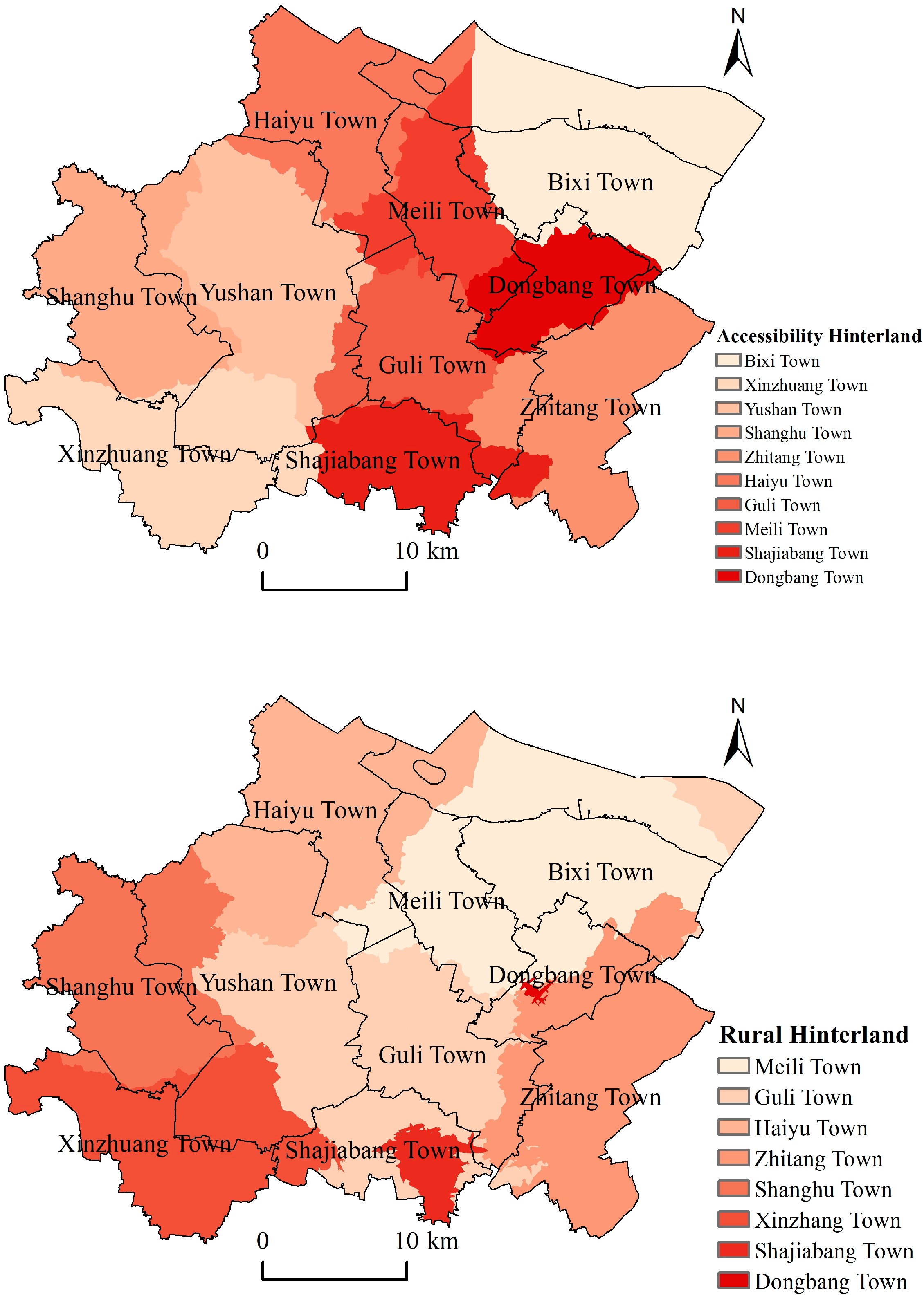
4.2.2. Spatial Field Definition for Villages and Towns Based on Town Center Accessibility and Tyson Polygons

The Tyson polygon indicates that the distance from any village settlement within a polygon to that town center is less than the distance to town centers within other polygons, reflecting a reasonable range of village spatial fields. The accessibility cost reflects the actual cost of reaching the town center, and to some extent, the actual extent of the village spatial field. The two were spatially superimposed to delineate the spatial radius of different township growth points in Changshu (Figure 5).
We found that: (1) The spatial field extent of the villages and towns did not correspond to the administrative boundaries, but the Tyson polygon tended to be consistent with the accessibility cost results, and the spatial field extent and tendency of each township was more in line with the desired results. (2) The spatial field range of the villages and towns was basically within the one-hour economic circle, with only the north-western part of Xinzhuang, the south–eastern part of Zhitang, Yushan, and the north-western part of Haiyu being within the one-and–a–half–hour economic circle. (3) The spatial field of the villages and towns was generally polycentric and “along the highway,” with one–and–a–half–hour economic circle of Haiyu, Meili, Dongbang, Zhitang, Yushan, Guli and Bixi, forming a continuous cluster distribution pattern. (4) There was a clear spatial convergence in the accessibility of some townships, with obvious areas of weak accessibility in the south of Shanghu, the north of Haiyu, the southeast of Zhitang and the east of Bixi. (5) The one–and–a–half hour village spatial fields of the 1, 2, 3 and 4 level village revitalization poles in northeast Changshu were comparable in scope. Although there is a large difference in influence values between townships, convenient transportation and improved infrastructure were conducive to promoting the linked development of village settlements in each township. As the center of the county town, Yushan has a strong ability to reach and radiate, but the spatial field of villages and towns was small and limited to the two–hour economic circle outward from the county town center within the administrative district boundary, as the village settlements there were mostly located in the peripheral areas outside the county town area, while its influence reaches the peripheral areas with difficulty due to the gradient attenuation effect of spatial distance and the substitution effect of the low–grade village revitalization pole. Therefore, the focus and emphasis on promoting rural revitalization in the future can be placed on the 2– and 3–level rural revitalization poles. Rural settlements located within the one-hour economic circle can be identified as a type of community–based development because they are close to the central towns, have a superior location and convenient facilities, have a more concentrated population size, and are advantageous zones for new urbanization development driven by the advantages of township industries, markets and employment [93].

4.2.3. Zone of Rural Development Based on the Rural Hinterland

The rural hinterland based only on the time cost of accessibility was analyzed together with the rural hinterland based on the combined effect of township influence and accessibility costs (Figure 6) to obtain a basic picture of the Changshu Rural Development Zone.
The division of the rural hinterland based on accessibility costs showed that the development areas did not correspond to the administrative boundaries and were easily extended to the boundaries of neighboring townships, with the rural development areas of each township nested within each other. The rural development zones of Shanghu, Xinzhang, Zhitang and Bixi not only covered the entire township but also extended to other areas, indicating that their accessibility costs are low and their accessibility is good. The other townships were all locally nested along their borders. In addition, the size of each town’s rural development area was generally consistent with the extent of its village spatial field, and the definition of the rural development areas in Shanghu and Xinzhuang are also consistent with development realities, with appropriate reductions and expansions based on accessibility costs.
The division of the rural hinterland based on the field strength model showed that its basic characteristics were consistent with those based on accessibility costs and only change in the hinterland scope. Specifically, Guli, Haiyu and Meili had the widest range of rural development zones as Level 1 and 2 rural revitalization poles, while Dongbang and Shajiabang had significantly reduced ranges of rural development zones because of their low level of influence compared to other townships and their relatively weak development drive on rural settlements in the surrounding areas. The scope of the rural development zones of Shanghu, Xinzhuang and Zhitang, the Level 3 rural revitalization poles, remains basically the same as the scope of the rural development zones based on accessibility costs, even expanding slightly. Although their township influence is at a medium level, the accessibility costs are relatively low, and the combined effect of the two results in larger rural development zones.
There follows the classification of types of rural settlement layout optimization under Rural Development Area. First, the scattered settlement patches within the Tyson polygon and one-hour economic circle of the county town and Bixi Street, which do not have significant scale agglomeration characteristics, should be set up as county urbanization demand-attracting types. Community development should be achieved through the central town drive. Second, clusters with high– or low–value aggregation within the rural development zones of the Level 1 and 2 rural revitalization poles and rural clusters within the one–hour economic circle of other townships should be set up as central township development potential types, strongly radiated by the township center and guaranteed the necessary land for in-situ urbanization development. They are the key targets for rural revitalization. Third, some rural settlements outside the one-hour economic circle and within the two–hour economic circle, relying on the development of various industries, sightseeing, agriculture, horticulture, e-commerce, and other specific industries, can be set up as special functional advantage development keeping types. Finally, regarding the scattered settlements outside the two–hour economic circle of each township in the marginal areas, although they are still in the hinterland, the radiation influence they can receive is weak. Measures such as relocation or settlement reconstruction can be offered to achieve concentrated living, thereby optimizing the intensive use of land. These settlements are the scattered relocation and support types.

4.2.4. Urban and Rural Infrastructure Network Based on Transport and Basic Public Services Connectivity

In the new development period, new urbanization and rural revitalization are two different means to improve the quality of urban–rural development and promote urban–rural integration. The main focus is on promoting the orderly flow of factors such as population, land, industry, science, education, facilities and policies between urban and rural areas to reshape a new pattern of urban–rural integrated development. The integration of facilities is a vital link. Promoting the gradual extension of urban infrastructure and public service facilities to rural areas to achieve universal sharing can help construct a network of paths for the effective flow of various factors and resources [96]. From 2017 to 2021, 115 urban roads were built or upgraded in Changshu, and all 1039 “cluster” villages had access to graded highways. The three–level bus service system of towns and villages was continuously optimized, and the connectivity between urban and rural areas was further improved. There is a need to accelerate the construction of various infrastructure and public service facilities covering both urban and rural areas, such as electricity, natural gas, waste and sewage treatment, logistics and rural power grids, and realize the integration of basic pension insurance, medical insurance and minimum living security benefits for urban and rural residents. Building a multi-level road network and facility system based on a multi-level rural revitalization pole improves the urban–rural infrastructure network that promotes the integrated development of Changshu’s cities and rural areas.
In conclusion, the spatial structure of urban and rural settlements in Changshu is clearly hierarchical. As the center and sub-center of Changshu, there is a clear connection channel between the county seat and the central and western regions, and Bixi connects with the east, and both of them drive the development of Changshu as a whole through organizational linkage. The rural revitalization poles at all levels are the key link between urban and rural areas, consolidating the settlement reconstruction system through horizontal and vertical linkages. Within each township, apart from the central township area, there are sub-township built-up areas in other areas of the township that depend on the development of township industry and special industries. These built-up areas influence the development of rural settlements away from the central township area and those on the fringes of neighboring townships. However, there are still some villages that generally lack young new agricultural operators, are located in marginal areas, have poor living and working conditions, and the “Beautiful Residence of Thousands of Villages” project is not strong in terms of continuity. Therefore, based on the level of influence of the townships, their geographical function, and the size of the settlements, the rural settlements within each Rural Development Area are further divided into county urbanization demand attraction type, central township development potential type, special function advantage development maintenance type and sporadic relocation support type, to promote the reorganization of rural settlements, improve quality and efficiency, achieve the multi-level objectives of rural revitalization and help promote urban–rural integration.

5. Discussion

An orderly and reasonable multi-stage urban–rural spatial structure is conducive to promoting synergistic urban–rural development, and the designation of multiple types of villages based on development conditions is conducive to promoting optimal adjustment of rural functions and layout. In 2021–2025, based on its own characteristics and advantages, Changshu will seize the strategic opportunities of the integration of the Yangtze River Delta and the integration of Shanghai and Suzhou, fully connect with Shanghai and Hangzhou, integrate into the main urban area of Suzhou, and strengthen the effective docking with the Yangtze River Delta urban agglomeration. In order to balance urban and rural development, a four-level urban and rural spatial system of “central city–town–rural community–village” is planned based on functional positioning. The central urban area includes the main urban area and port area, which respectively refer to Yushan and Guli of grade 1 rural revitalization, Bixi and Meili of grade 2 rural revitalization. Based on the comprehensive analysis of village development conditions and potential, the current situation of the village is divided into five types: agglomeration promotion, characteristic protection, suburban integration, relocation and removal, and other general categories. However, due to different functional positioning and development conditions, the classification types of village layout in each town are different. For example, Haiyu Town, which is functioned as a new material industry base in the Yangtze River Delta and a service center in the northwest of the city, is divided into four types of integrated villages, city–level controlled villages, tow–level controlled villages and comprehensive regulated villages in the comprehensive renovation planning. Dongbang Town, which functions as a key transportation town in the east of the city and a modern comprehensive town featuring emerging industries, classifies all villages in the town into two categories: renovation type and replacement type.
The multi-stage spatial structure revealed in this study corresponds to the development plan of Changshu city, and the village types were also delineated to promote the optimization of rural settlement layout, attracted by the county urbanization demand attraction type, central township development potential type, special function advantage development maintenance type and sporadic relocation support type. However, only accessibility and township influence were considered in this demarcation, and functional orientation and development conditions were not considered. Therefore, the village types were different from the reality, and the differences between towns were not emphasized. Future research should fully consider the functional orientation and development characteristics of each township, combine with the reality of rural development, formulate differentiated development guidance and further analyze the evolutionary mechanism of the rural settlement system. In addition, due to the limitation of data acquisition, facilities level was not included in the measurement of township influence. In the next research, field survey, semi-structured interview and other methods can be adopted to collect relevant data and supplement the case studies at the village scale. With typical villages, with cluster promotion, suburban integration, characteristic protection and relocation and merger as the entry points, specific optimization plans can be formulated to expand the policy application value of the research results.

6. Conclusions

This paper explored the spatial and temporal evolution characteristics of the rural settlement system in Changshu over the past 20 years from 2000 to 2020, using GIS spatial analysis, fractal dimension and the field strength model, and the spatial structure of rural settlement development in economically developed areas was revealed based on the multi-stage objective of “pole–field–zone–network”. The measurement of the evolution of the settlement pattern and the settlement optimization model to construct the village hierarchy and identify the growth pole with the help of the field strength model can, to some extent, provide a research basis and reference for formulating a reasonable spatial hierarchy system of towns and villages at the county level and village consolidation planning. The main conclusions of the study are presented below.
The evolution of the spatial distribution pattern and scale structure system of rural settlements in Changshu City experienced two periods of drastic change and stable adjustment. Now, it is still in the latter period. In order to achieve the goal of rural revitalization, Changshu continues to optimize the village layout, renovate the village environment, and formulate a comprehensive village renovation plan to adjust the structure and layout of rural settlements. The density distribution of rural settlements in Changshu generally shows a spatial pattern of dense in the north and sparse in the south, dense in the east and sparse in the west. The number of rural settlements per unit area is increasing and tending to cluster. The scale structure of rural settlements in Changshu city changed from centralization to dispersion, with the polarization of the scale system of rural settlements enhanced and the gap between the scale of the first and last settlements increased. This has something to do with carrying out the project of “a thousand beautiful villages” and delineating the development of group–type villages. The actual scale of rural settlements was much lower than the theoretical value, and the small and medium–sized settlements were underdeveloped. The spatial agglomeration of settlement size distribution gradually increased, and the location of hot and cold areas shifted from south to north. However, the agglomeration area was relatively small, and the transition area was wide, so the optimization of settlement structure layout still had certain adjustment potential.
The multi-stage objective system of “pole–field–zone–network” constructed against the goal of rural revitalization is helpful to promote the optimization of rural settlement layout in Changshu City, and promote the construction of a reasonable urban–rural network structure. The influence of towns in the middle and north of Changshu is higher than that in the south, with a distinct hierarchy of rural revitalization poles. The spatial extent and development trends of the villages and towns are in line with the desired results, with the areas basically within a two-hour economic circle, showing a polycentric circle pattern and a “roadside” pattern. The size of rural development areas based on hinterland delineation corresponds to the extent of village spatial fields and does not correspond to administrative boundaries, nesting and influencing each other spatially. The urban–rural infrastructure network, built on transport and basic public service links, has become the link between the orderly flow of urban and rural factors. Guided by the importance of rural revitalization, with the spatial field of villages and towns and the rural development area as the role field, under the linkage of the urban–rural foundation network, the county city and Bixi sub-center bear the east and enlighten the west, promoting the orderly development of the county city urbanization demand–attracting type, the central township development potential type, the special functional advantage development maintaining type, and the sporadic relocation and support type villages, thereby realizing multi–level linkage of the whole area urban–rural integration, in line with the actual development of rural settlements in economically developed areas.

Author Contributions

Conceptualization, methodology, formal analysis, writing—original draft preparation, B.Z. and Z.H.; software, resources, data curation, visualization Z.H., Y.W. and J.C.; validation, supervision, project administration, H.L. and B.Z.; writing—review and editing, H.L., B.Z., Z.H., Y.W. and J.C.; funding acquisition, B.Z. and H.L. All authors have read and agreed to the published version of the manuscript.

Funding

This research was funded by Natural Science Foundation of the Higher Education Institutions of Jiangsu Province of China, grant number: 21KJB170013; National Social Science Foundation of China Post-grant Program, grant number: 21FSHB014; Humanities and Social Sciences Foundation of the Ministry of Education of China, grant number: 20YJCZH069 and National Natural Science Foundation of China, grant number: 42071224.

Institutional Review Board Statement

Not applicable.

Informed Consent Statement

Not applicable.

Data Availability Statement

Not applicable.

Conflicts of Interest

The authors declare no conflict of interest.

References

  1. Zhang, X.L. An analysis of the concept of countryside. Acta Geol. Sin. 1998, 53, 365–371. [Google Scholar] [CrossRef]
  2. Ji, Z.X.; Xu, Y.Q.; Lu, L.H.; Duan, Y.M.; Li, Y.Y.; Huang, A. Progress and prospects of spatial optimization of rural settlements. China Land Sci. 2021, 35, 95–104. [Google Scholar] [CrossRef]
  3. Qiu, Y.M.; Jiao, Y.M.; Yang, Y.L.; Li, Y.; Li, H.; Zhao, D.M.; Liu, C.J.; Zhang, J. The distribution pattern of Hani settlements and their evolution mechanism: An example from Quanfuzhuang Zhongzhai, Yuanyang County, Yunnan Province. Areal Res. Dev. 2021, 40, 44–50+57. [Google Scholar]
  4. Ma, X.D.; Li, Q.L.; Shen, Y. Morphological differentiation and geographical types of rural settlements in Jiangsu Province. Acta Geol. Sin. 2012, 67, 516–525. [Google Scholar] [CrossRef]
  5. Song, W.; Li, H. Spatial pattern evolution of rural settlements from 1961 to 2030 in Tongzhou District, China. Land Use Policy 2020, 99, 105044. [Google Scholar] [CrossRef]
  6. Tu, S.S.; Zhou, X.Y.; Long, H.L.; Liang, X.L. Progress and prospects of research on spatial evolution and optimization of rural settlement. Econ. Geogr. 2019, 39, 142–149. [Google Scholar] [CrossRef]
  7. Robinson, P. Implications of rural settlement patterns for development: A historical case study in Qaukeni, Eastern Cape, South Africa. Dev. S. Afr. 2003, 20, 405–421. [Google Scholar] [CrossRef]
  8. Woods, M. Engaging the global countryside: Globalization, hybridity and the reconstitution of rural place. Prog. Hum. Geogr. 2007, 31, 485–507. [Google Scholar] [CrossRef]
  9. Hoke, G.W. The study of social geography. Geogr. J. 1907, 29, 64–67. [Google Scholar] [CrossRef]
  10. Fawcett, C.B. The distribution of rural settlements. Geogr. J. 1939, 13, 152–155. [Google Scholar]
  11. Gilbert, E.; Steel, R. Social geography and its place in colonial studies. Geogr. J. 1945, 106, 118–131. [Google Scholar] [CrossRef]
  12. Stone, K.H. Regionalization of Spanish units of settlement. Tijdshrifi Voor Econ. En Soc. geografie 1968, 61, 232–241. [Google Scholar] [CrossRef]
  13. Hudson, J.C. A location theory for rural settlement.Annals. Ann. Am. Assoc. Geogr. 1969, 59, 365–381. [Google Scholar] [CrossRef]
  14. Rowley, G. Central places in rural Wales. Ann. Am. Assoc. Geogr. 1971, 61, 537–550. [Google Scholar] [CrossRef]
  15. Haining, R. Describing and modelling rural settlement maps. Ann. Am. Assoc. Geogr. 1982, 72, 211–223. [Google Scholar] [CrossRef]
  16. Pacione, M. The viability of smaller rural settlements. Tijdshrift Voor Econ. En Soc. Geogr. 1982, 73, 149–161. [Google Scholar] [CrossRef]
  17. Zhang, X.L. Rural Spatial System and Its Evolution: A Case Study of Southern Jiangsu Province; Nanjing Normal University Press: Nanjing, China, 1999. [Google Scholar]
  18. Wang, L.H.; Yu, J.G.; Zhang, X.L. A review of studies on rural social geography abroad. Hum. Geogr. 2006, 21, 100–105. [Google Scholar]
  19. Cloke, P. (En)culturing Political Culture: A Life in the Day of a ‘Rural Geographer’. In Writing the Rural: Five Cultural Geographies; Cloke, P., Doel, M., Matless, D., Phillips, M., Thrift, N., Eds.; Paul Chapman: London, UK, 1994; pp. 149–190. [Google Scholar]
  20. Seymour, S. Theoretical developments in rural geography: Concepts and methods. Area 1996, 28, 274–275. [Google Scholar]
  21. Jones, O. Lay discourses of the rural: Development and implications for rural studies. J. Rural. Stud. 1995, 11, 35–49. [Google Scholar] [CrossRef]
  22. Little, J.; Austin, P. Women and the rural idyll. J. Rural. Stud. 1996, 12, 101–111. [Google Scholar] [CrossRef]
  23. Sillince, J.A. Why did Warwickshire key settlement policy change in1982? An assessment of the political implications of cuts in rural services. Geogr. J. 1986, 152, 176–192. [Google Scholar] [CrossRef]
  24. Shubin, S. The changing nature of rurality and rural studies in Russia. J. Rural. Stud. 2006, 22, 422–440. [Google Scholar] [CrossRef]
  25. Halfacree, K. Locality and social representation: Space, discourse and alternative definitions of the rural. J. Rural. Stud. 1993, 9, 23–37. [Google Scholar] [CrossRef]
  26. Murdoch, J.; Pratt, A. Rural studies of power and the power of rural studies: A reply to Philo. J. Rural. Stud. 1994, 10, 83–87. [Google Scholar] [CrossRef]
  27. Oksa, J. Regional and Local Responses to Restructuring in Peripheral Rural Areas in Finland. Urban Stud. 1992, 29, 991–1002. [Google Scholar] [CrossRef]
  28. Peter, B. Nelson. Rural restructuring in the American West: Land use, family and class discourses. J. Rural. Stud. 2001, 17, 395–407. [Google Scholar]
  29. Olivia, J. Wilson. Rural Restructuring and Agriculture-Rural Economy Linkages: A New Zealand Study. J. Rural. Stud. 1995, 11, 417–431. [Google Scholar]
  30. Marsden, T. Rural Geography Trend Report: The Social and Political Bases of Rural Restructuring. Prog. Hum. Geogr. 1996, 20, 246–258. [Google Scholar] [CrossRef]
  31. Tigges, L.M.; Ziebarth, A.; Farnham, J. Social Relationships in Locality and Livelihood: The Embeddedness of Rural Economic Restructuring. J. Rural. Stud. 1998, 14, 203–219. [Google Scholar] [CrossRef]
  32. Turnock, D. Rural diversification in Eastern Europe: Introduction. Geogr. J. 1998, 46, 171–181. [Google Scholar]
  33. Hoggart, K.; Paniagua, A. The Restructuring of Rural Spain? J. Rural. Stud. 2001, 17, 63–80. [Google Scholar] [CrossRef]
  34. Roche, M. Rural Geography: Searching Rural Geographies. Prog. Hum. Geogr. 2002, 26, 823–829. [Google Scholar] [CrossRef]
  35. Woods, M. Rural Geography: Processes, Responses and Experiences in Rural Restructuring; Sage: London, UK, 2005. [Google Scholar]
  36. Kiss, E. Rural restructuring in Hungary in the period of socio-economic transition. Geogr. J. 2000, 51, 221–233. [Google Scholar]
  37. Brown, D.L. Post-Socialist Restructuring and Population Redistribution in Hungary. Rural. Sociol 2005, 70, 336–359. [Google Scholar] [CrossRef]
  38. Bigmore, P. Rural Process-Pattern relationships: Nomadization, Sedentarization and Settlement Fixation. Geogr. J. 1994, 160, 98. [Google Scholar] [CrossRef]
  39. Woods, M. Discourses of Power and Rurality—Local Politics in Somerset in the 20th Century. Political Geogr. 1997, 16, 453–478. [Google Scholar] [CrossRef]
  40. Woods, M. Researching Rural Conflicts: Hunting, Local Politics and Actor-networks. J. Rural. Stud. 1998, 14, 321–340. [Google Scholar] [CrossRef]
  41. Lowe, P.; Ward, N. British Rural Geography: A Disciplinary Enterprise in Changing Time; Routledge: London, UK, 2007; pp. 1–20. [Google Scholar]
  42. Duram, L.; Archer, J.C. Contemporary Agriculture and Rural Land Use; Oxford University Press: New York, NY, USA, 2003; pp. 326–338. [Google Scholar]
  43. Forbes, W.; Katkins, S.L. Rural development; Oxford University Press: New York, NY, USA, 2003; pp. 339–349. [Google Scholar]
  44. Madsen, L.M.; Adriansen, H.K. Knowledge constructions in research communities: The example of agri-rural researchers in Denmark. J. Rural. Stud. 2006, 22, 456–468. [Google Scholar] [CrossRef] [Green Version]
  45. Kurtz, M.; Craig, V. Constructing rural geographies in publication. ACME Int. E-J. Crit. Geogr. 2009, 8, 376–393. [Google Scholar]
  46. Woods, M. Exploring the uneven geographies of ‘rural geography’. ACME Int. E-J. Crit. Geogr. 2009, 8, 394–413. [Google Scholar]
  47. Cloke, P.; Marsden, T.; Mooney, P.H. Handbook of Rural Studies; Sage: London, UK, 2006; pp. 18–28. [Google Scholar]
  48. Marsden, T. Third natures? Reconstituting space through place making strategies for sustainability. J. Sociol. Agric. Food 2012, 19, 257–274. [Google Scholar]
  49. Woods, M. Regions engaging globalization: A typology of regional responses in rural Europe. J. Rural. Community Dev. 2013, 8, 113–126. [Google Scholar]
  50. Imperiale, A.J.; Vanclay, F. Experiencing local community resilience in action: Learning from post-disaster communities. J. Rural. Stud. 2016, 47, 204–219. [Google Scholar] [CrossRef]
  51. Barbosa, V.; Santé-Riveira, I.; Crecente-Maseda, R.; Redondo, C.D.; Trinidad, J.P.; López, J.P.; Biempica, R.D.; Ferreira Neto, J.A. A New Spatial Criteria Method to Delimit Rural Settlements towards Boundaries Equity: Land Use Optimization for Decision Making in Galicia, NW Spain. Land 2022, 11, 800. [Google Scholar] [CrossRef]
  52. Njoh, A.J. Municipal councils, international NGOs and citizen participation in public infrastructure development in rural settlements in Cameroon. Habitat Int. 2011, 35, 101–110. [Google Scholar] [CrossRef]
  53. Li, X.D.; Jin, Q.M. Consolidation of rural settlements in Jiangsu Province. Econ. Geogr. 1983, 2, 54–57. [Google Scholar]
  54. Chen, Q. The formation and development of settlements in Shaoxing area in historical period. Acta Geol. Sin. 1980, 1, 16–25. [Google Scholar]
  55. Chen, Z.X.; Yin, H.T. Distribution characteristics and evolution of rural settlements in Shanxi Province. Hum. Geogr. 1995, 10, 17–24. [Google Scholar]
  56. Wan, Q.; Xu, X.R. Quantitative study and application of spatial distribution characteristics of rural residents in flood plain. Geogr. Res. 1997, 16, 47–54. [Google Scholar]
  57. Ma, C.; Wang, H.W.; Tan, B.; Zhou, J.; Dai, X.Y.; Wang, X.Q. Scale system characteristics and spatial reconstruction of urban and rural settlements in a typical oasis in Xinjiang: The example of the Weigan River-Kuche River Delta Oasis. Acta Geol. Sin. 2022, 77, 852–868. [Google Scholar]
  58. Ma, L.B.; Gong, M.; Liu, S.C.; Cui, X.J. Spatial reconfiguration type identification of rural settlements based on residential suitability: An example of Weidian town in Longzhong Loess hilly area. Sci. Geol. Sin. 2022, 42, 456–465. [Google Scholar] [CrossRef]
  59. Huang, W.Z.; Shi, P.J. An empirical study on the cumulative scale model of rural settlements in the Huanghuang region. Acta Geol. Sin. 2021, 76, 1489–1503. [Google Scholar] [CrossRef]
  60. Dong, X.P.; Deng, J.J.; Zhao, M.X. Study on the spatial aggregation of rural settlements in the loess gully area of northern Shaanxi. Chin. J. Agric. Resour. Reg. Plan. 2021, 42, 155–161. [Google Scholar]
  61. Feng, Y.B.; Long, H.L. Progress and prospects of spatial reconstruction of rural settlements in mountainous areas of China. Prog. Geogr. 2020, 39, 866–879. [Google Scholar] [CrossRef]
  62. Ma, X.R.; Cha, X.C. Spatial distribution characteristics and influencing factors of rural settlements in the Qinba Mountains in southern Shaanxi Province--Hanzhong City, Shaanxi Province as an example. Res. Soil Water Conserv. 2021, 28, 307–314. [Google Scholar] [CrossRef]
  63. Li, C.; Wu, Y.M.; Gao, B.J.; Wu, Y.; Zheng, K.J.; Li, C. Spatial differentiation of rural settlements in highland lakes and the detection of driving forces: An example from the Erhai Rim. Econ. Geogr. 2022, 42, 220–229. [Google Scholar] [CrossRef]
  64. Zhu, J.G.; Li, X.J. A study on the characteristics of the evolution of the hierarchical scale of rural settlements in traditional farming areas: The case of Zhoukou City, Henan Province. Areal Res. Dev. 2020, 39, 133–137. [Google Scholar]
  65. Huang, Y.P.; Zheng, Y.X. Morphological types and spatial system characteristics of rural settlements in the Jianghan Plain. Sci. Geol. Sin. 2021, 41, 121–128. [Google Scholar] [CrossRef]
  66. Kong, X.S.; Zhu, Z.Q.; Liu, D.F. Multi-scale characteristics and spatial correlation analysis of rural settlement evolution in Jiangsu Province. Trans. Chin. Soc. Agric. Eng. 2020, 36, 247–256+329. [Google Scholar] [CrossRef]
  67. Zhang, J.F.; Liu, X.Y.; Wang, L. Distribution characteristics of rural settlements and determination of urbanization level in southwestern ethnic areas. Chin. J. Agric. Resour. Reg. Plan. 2021, 42, 162–169. [Google Scholar]
  68. Qiao, L.Y.; Liu, Y.S.; Yang, R. Types and control strategies of rural residential land change in China. Trans. Chin. Soc. Agric. Eng. 2015, 31, 1–8. [Google Scholar]
  69. Zhou, G.H.; He, Y.H.; Tang, C.L. Driving mechanism and situation analysis of rural settlement evolution in China. Acta Geol. Sin. 2011, 66, 515–524. [Google Scholar]
  70. Li, N.; Jiang, S. Study on spatial pattern of rural settlements in Wuling mountainous area based on GIS. Wirel. Pers. Commun. 2018, 102, 2745–2757. [Google Scholar] [CrossRef]
  71. Li, H.; Song, W. Pattern of spatial evolution of rural settlements in the Jizhou District of China during 1962–2030. Appl. Geogr. 2020, 122, 102247. [Google Scholar] [CrossRef]
  72. Yang, R.; Liu, Y.; Long, H.; Qiao, L. Spatio-temporal characteristics of rural settlements and land use in the Bohai Rim of China. J. Geogr. Sci. 2015, 25, 559–572. [Google Scholar] [CrossRef]
  73. Xi, J.; Wang, X.; Kong, Q.; Zhang, N. Spatial morphology evolution of rural settlements induced by tourism. J. Geogr. Sci. 2015, 25, 497–511. [Google Scholar] [CrossRef]
  74. Kong, X.; Liu, D.; Tian, Y.; Liu, Y. Multi-objective spatial reconstruction of rural settlements considering intervillage social connections. J. Rural Stud. 2021, 84, 254–264. [Google Scholar] [CrossRef]
  75. Tang, C.; He, Y.; Zhou, G.; Zeng, S.; Xiao, L. Optimizing the spatial organization of rural settlements based on life quality. J. Geogr. Sci. 2018, 28, 685–704. [Google Scholar] [CrossRef]
  76. Long, H.; Liu, Y.; Wu, X.; Dong, G. Spatio-temporal dynamic patterns of farmland and rural settlements in Su–Xi–Chang region: Implications for building a new countryside in coastal China. Land Use Policy 2009, 26, 322–333. [Google Scholar] [CrossRef]
  77. Lu, D.D. Analysis on the formation mechanism of “point-axis” spatial structure system. Sci. Geol. Sin. 2002, 1, 1–6. [Google Scholar]
  78. Liu, Y.S. Urban and rural integration and Rural Revitalization in the new era of China. Acta Geol. Sin. 2018, 73, 637–650. [Google Scholar]
  79. Liu, Y.S. Basic theory and methodology of Rural Revitalization Planning in China. Acta Geol. Sin. 2020, 75, 1120–1130. [Google Scholar]
  80. Xin, X.C.; Shao, L.; Gu, Z.L.; Wei, J.W. From “What to Do” to “What Not to Do”: The Construction of County Spatial Control System Based on "Multi-regulation Integration. Urban Dev. Stud. 2016, 23, 15–21. [Google Scholar]
  81. Cui, G.H.; Xu, S.Y. Some problems of County town system planning. City Plan. Rev. 2001, 7, 25–27. [Google Scholar]
  82. Cui, G.H. Some problems of small town planning. Dev. Small Cities Towns 2000, 1, 44–45. [Google Scholar]
  83. Shi, Y.W.; Li, X.J.; Zhang, S.N.; Chen, Q. Spatial evolution and driving mechanism of settlements in typical agricultural industrialization areas--a case study based on Yanling County, Henan Province. J. Areal Res. Dev. 2022, 41, 139–144+161. [Google Scholar] [CrossRef]
  84. Wu, J.G.; Zhang, X.L.; Ji, Y.Z. A comparative analysis of the fractal characteristics of rural settlements in the plain areas of southern Jiangsu and northern Anhui--Taking Zhenjiang Danyang City and Suzhou Yongqiao District as examples. Resour. Environ. Yangtze Basin 2014, 23, 161–169. [Google Scholar]
  85. Liu, J.S.; Chen, Y.G. Fractal dimension of town system hierarchy and its measurement method. Geogr. Res. 1998, 17, 82–89. [Google Scholar] [CrossRef]
  86. Liu, J.S.; Chen, T. A fractal study of the spatial structure of the town system in Northeast China. Sci. Geol. Sin. 1995, 15, 23–24. [Google Scholar]
  87. Lin, J.P.; Lei, J.; Wu, S.X.; Yang, Z.; Li, J.G. Spatial distribution characteristics of rural settlements in Xinjiang oasis and its influencing factors. Geogr. Res. 2020, 39, 1182–1199. [Google Scholar] [CrossRef]
  88. Zhang, L.; Lu, Y.Q. Study on the scope of urban influence and spatial development trend in Hebei Province. J. Geogr. Tere Res. 2001, 17, 11–15. [Google Scholar] [CrossRef]
  89. Liu, J.S.; Chen, Y.G. The general form and application method of fractal city gravity model. Sci. Geol. Sin. 2000, 20, 266–272. [Google Scholar]
  90. Zeng, B.; Zhang, Y.; Hu, Y.G. Identification of urban hinterland extent based on accessibility and urban competitiveness: An example of the middle reaches of the Yangtze River urban agglomeration. Trop Geogr. 2020, 40, 119–127. [Google Scholar] [CrossRef]
  91. Yin, L.; Li, M.C.; Tao, Y. Study on the impact of township land use planning on the accessibility of rural residents. GAGIS 2006, 22, 62–66. [Google Scholar] [CrossRef]
  92. Li, H.B.; Wu, J.G.; Zhang, X.L.; Li, C.W. The distribution characteristics and formation mechanism of rural industrial land under the “southern Jiangsu model”: The case of Changshu City. Econ. Geogr. 2018, 38, 52–159. [Google Scholar] [CrossRef]
  93. Li, H.B.; Liu, M.D.; Hu, X.L.; Chen, X.H. Spatial change characteristics and typology of rural habitat from the perspective of smart shrinkage--Take Changshu City, Jiangsu Province as an example. Geogr. Res. 2020, 39, 939–955. [Google Scholar] [CrossRef]
  94. Qu, L.L.; Li, Y.R.; Liu, Y.S. Study on the optimization of village settlement layout based on the “object-field” model of village space. Econ. Geogr. 2019, 39, 174–181. [Google Scholar] [CrossRef]
  95. Qiao, J.J. Application of Improved Entropy Method in the Assessment of Sustainable Development Capability in Henan Province. Resour. Sci. 2004, 26, 113–119. [Google Scholar]
  96. Fang, C.L. A theoretical analysis of the mechanism and evolutionary law of urban-rural integration development. Acta Geol. Sin. 2022, 77, 759–776. [Google Scholar] [CrossRef]
Figure 1. Location of areas covered in Changshu City. Note: “Waters” are open water bodies for ecological protection and ports.
Land 11 01412 g001
Figure 2. Density map of rural settlements in Changshu.
Land 11 01412 g002
Figure 3. Double logarithmic coordinate map of settlement size distribution.
Land 11 01412 g003
Figure 4. Hot Spot Map of rural settlement scale differentiation in Changshu.
Land 11 01412 g004
Figure 5. Village space field in Changshu.
Land 11 01412 g005
Figure 6. Overlay of Changshu’s rural hinterland and administrative boundaries.
Land 11 01412 g006
Table 1. Township Impact Measurement Indicator System.
Guideline LevelIndicator LevelIndicator InterpretationWeight
Comprehensive EconomyGDP of townships (million yuan)Reflecting the comprehensive economic strength of the township.0.057
Government FinanceTotal financial revenue
(million yuan)
Reflecting the financial strength of the township government.0.067
General public budget revenue (million yuan)Reflecting the level of disposable financial resources of the township government and the state of regional enterprises, economic performance, and consumer sentiment.0.078
Population SizeTotal population (persons)Reflecting the population base and development potential.0.085
Land ScaleTownship built-up area (km2)Reflecting the agglomeration scale and attraction of township construction land.0.199
Cultivated area (hectare)Reflecting the base of agricultural development and the capacity of agricultural production factors to cluster.0.114
Industrial DevelopmentNumber of township enterprises (pcs)Reflecting the development of non-agricultural industries and the ability of the township to absorb non-agricultural employment.0.083
Number of industrial enterprises above designated size (pcs)Reflecting the development of township industry.0.090
Township employees (persons)Reflecting the level of non-farm employment in the townships.0.079
Proportion of output value of secondary and tertiary industries in GDP (%)Reflecting the industrial structure of the township.0.050
Number of general shops or supermarkets with a business area of 50 m2 or more (pcs)Reflecting the tertiary sector and consumer retail in the township.0.098
Table 2. Rural Revitalization Pole of Changshu.
TownshipsMeili TownHaiyu TownGuli TownShajiabang TownZhitang TownDongbang TownXinzhuang TownShanghu Town
Influence0.5580.6540.7430.2020.4480.0480.4870.462
Level21143433
Note: The levels are classified into 4 classes based on the natural fracture method of ArcGIS 10.5.
Publisher’s Note: MDPI stays neutral with regard to jurisdictional claims in published maps and institutional affiliations.

