
The Transformation of Indigenous Landscape in the First Colonized Region of the Caribbean


Department of History and Classical Studies, Aarhus University, 8270 Højbjerg, Denmark
Land 2022, 11(4), 509; https://doi.org/10.3390/land11040509
Submission received: 4 March 2022
/
Revised: 21 March 2022
/
Accepted: 23 March 2022
/
Published: 31 March 2022
(This article belongs to the Special Issue Archaeological Landscape and Settlement)
Abstract
:This paper presents an archaeological reconstruction of indigenous landscape transformations in the first colonized region of the Caribbean. The arrival of Columbus in 1492 in the northern region of the island of Haytí (the current Dominican Republic and Haiti) signified a profound change in the lives of the island’s communities, transforming their everyday actions and their perceptions of landscape. To address this complex topic, this research tackled a key problem in landscape archaeology: while the “landscape” concept has been extensively debated, there is a growing tendency to use the concept without clear definitions and to obscure important methodological aspects of how scholars bridge the divide between their conceptual definitions and the archaeological record. This paper approaches this problem by applying the concepts of ‘sites as tendencies’ and ‘contested taskscapes’. This theoretical and methodological framework allows for the reconstruction of the indigenous landscape and, more importantly, highlights how the colonization process impacted the everyday tasks and perceptions of Hayti’s indigenous people through the profound transformation of their landscape.
1. Introduction
The idea of landscape as used in archaeology today is a complex product of decades of archaeological, anthropological and geographical debates [1,2,3,4,5,6,7,8,9]. In particular, the ambiguous use of the concept today [10] reflects the challenges faced by both processual and post-processual archaeologists in making sense of past realities within their specific theoretical frameworks [11,12,13,14]. This dichotomy between processual and postprocessual trends is still palpable, yet clear discussions on the methodological implications of these two very different approaches are less common. One group of scholars continues to use the concept of landscape in the processual sense, i.e., they understand landscape as the passive environmental context for human behavior. By contrast, other researchers use the term to refer to the resulting cultural meanings that humans create in the process of interacting with their surroundings. The issue does not arise from the use of either of these perspectives on landscape per se, but rather the lack of explicit discussion of their methodological and theoretical implications, particularly when scholars seek to draw on a combination of both perspectives.
This problem becomes salient when, for instance, one tries to combine the advantages of regional survey, geographical information systems, and spatial statistics with a conceptual framework that studies transformations in landscape perception as a result of cultural conflict. For this, an articulation of processual and postprocessual methods and theories is imperative. The proposal presented in this paper is based on Tim Ingold’s idea of the Dwelling perspective. Over 30 years ago, Ingold suggested a way to overcome the dual and supposedly contradictory ideas of landscape from the processual and post-processual perspectives in archaeology. Ingold aimed “to move beyond the sterile opposition between the naturalistic view of the landscape as a neutral, external backdrop to human activities, and the culturalistic view that every landscape is a particular cognitive or symbolic ordering of space.” [15]. The key to achieving this, lay in the realization that the full power of the landscape concept extends beyond the visual and includes “a world in which we can expect to find formations of the land such as hills and valleys, mountains and plains, interspersed with settlements such as villages and towns and threaded by paths, roads and waterways.” [16]. For Ingold, there was no fundamental difference between ‘landscape’ and ‘environment’, as both are the result of the intertwining combinations of natural and cultural elements over time. The result of the histories of interactions between people, things and nature are that “landscape is not land looked at but land shaped… In this medieval sense, landscape already couples the land with tasks of shaping: landscape is taskscape because to shape the land is to work it” [17].
Ingold used the concept of taskscape to articulate the complexities of the intertwinement between people, things, tasks and the environment [4]. The concept of taskscape is a bridge between two realms: for archaeology, it can be a heuristic tool that connects the shape and content of the archaeological record with the idea of landscape. There are several recent examples of the use of taskscape in archaeology, for example see: [18,19,20,21]. In the Haytí case study, working through the taskscape perspective allowed for the integration of material evidence (e.g., archaeological sites and artefact distributions at the regional scale) with theoretical notions about human movement, action, and landscape knowledge at different spatial scales. This integration, in turn, proved key to understanding both the ways that indigenous tasks shaped the island’s landscape and how these were collectively transformed after 1492.
Yet, for two important reasons, the taskscape concept by itself was not sufficient to properly achieve the desired goal of this research. First, in order to avoid ambiguities in the use of ‘landscape’ and ‘taskscape’, clearly defined spatial categories had to be developed. Following an extensive review of the concept of the archaeological site, the notion of ‘sites as tendencies’ was elaborated as a means of defining of taskscapes in the archaeological record. Second, as the case study focused on contexts of colonial war, enslavement and displacement, the concept of taskscape was reconsidered in terms of how it might relate to the contexts of conflict that the indigenous people suffered. To overcome this second challenge, current debates over landscape, colonization and conflict in archaeology were drawn on to create the idea of ‘contested taskscapes’.
A complete review of the arguments for the definition of these two concepts is beyond the scope of this paper [22]. In general terms, the idea of ‘sites as tendencies’ is based on the understanding that human actions in the world leave traces of their particular intentions and activities, which, in addition to their spatial recurrence, also tend to be recurrent in time. Each particular site contains evidence of one or more tasks that were carried out by human actors in particular environmental contexts and places. The analysis of materials and sites from this perspective allows for a clear definition of taskscapes that articulates directly with the archaeological record. The idea of ‘contested taskscapes’ came as a second stage in the analytical process and emerged through the combination of Ingold’s taskscape [4] and Bender’s work on contested landscapes [23,24,25]. Briefly stated, the contested taskscape concept permitted the identification and classification of the material evidence and patterns left on the terrain by cultural conflicts in the past. By grouping and categorizing these conflicts on the ground, it was possible to identify contested taskscapes and define the resulting landscape transformations.
2. Material and Methods
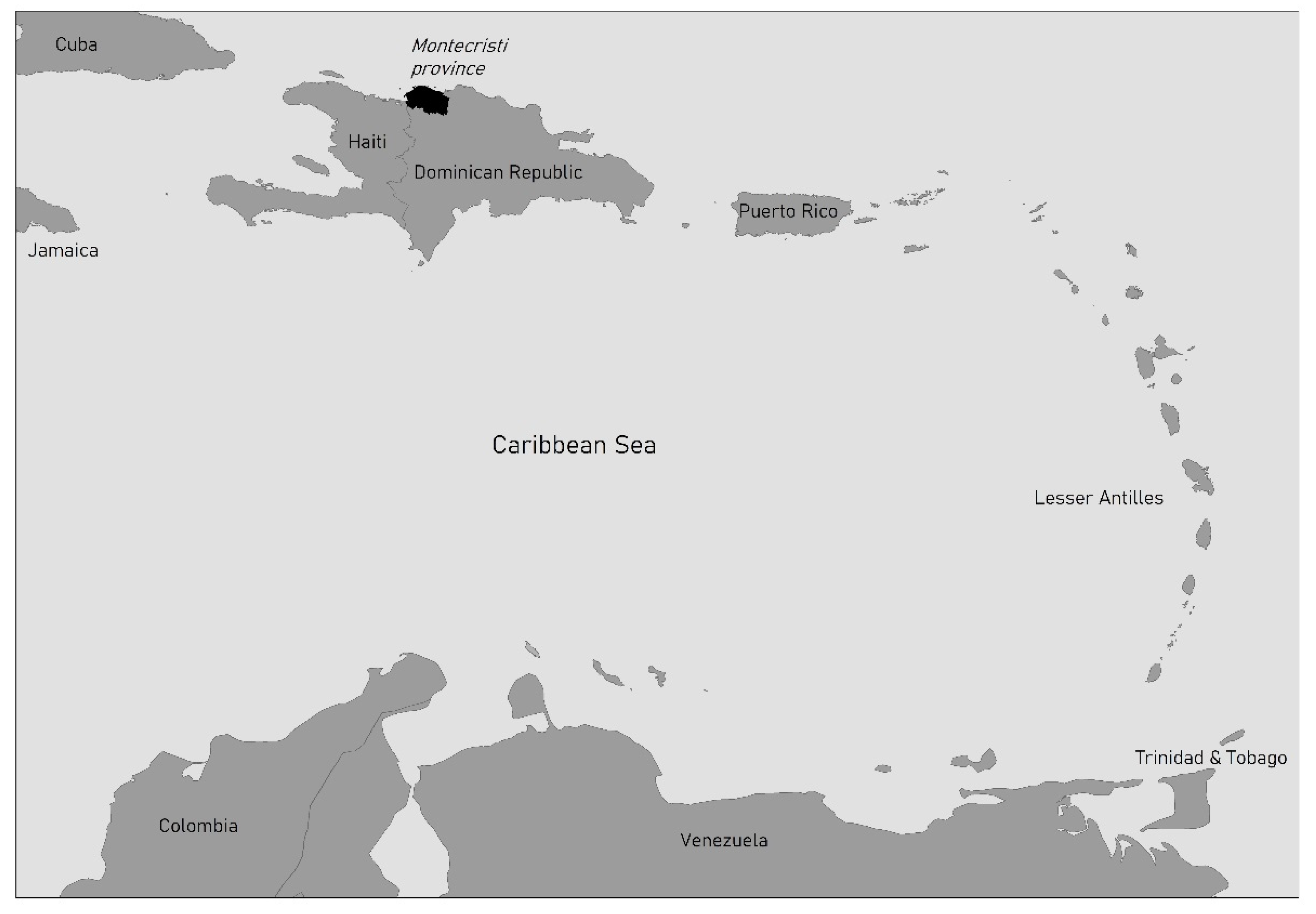
The study area where these two concepts were explored was the coast of Montecristi, a province located in the northwestern Dominican Republic (Figure 1). After several field seasons in the region, a total of 102 previously unregistered archaeological sites were recorded and grouped by size, location, ceramic affiliation and function [26].
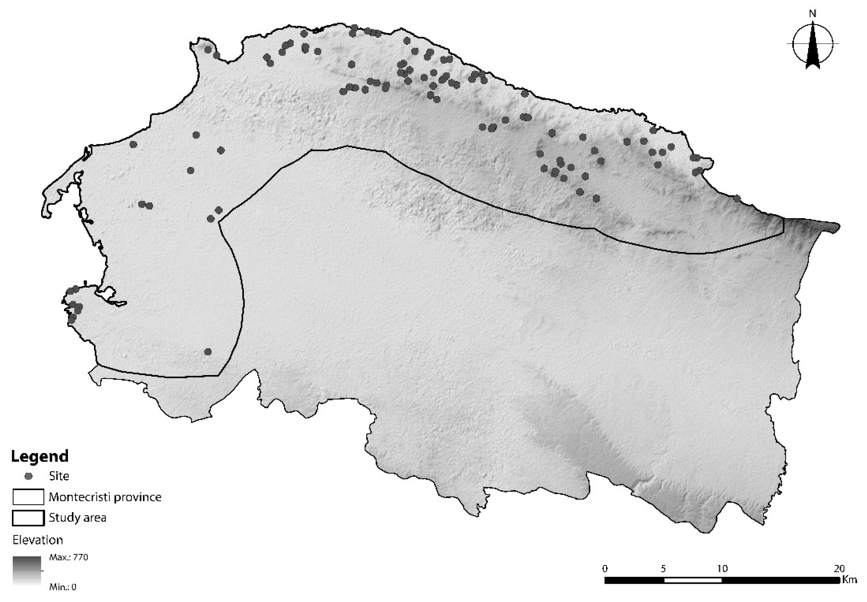
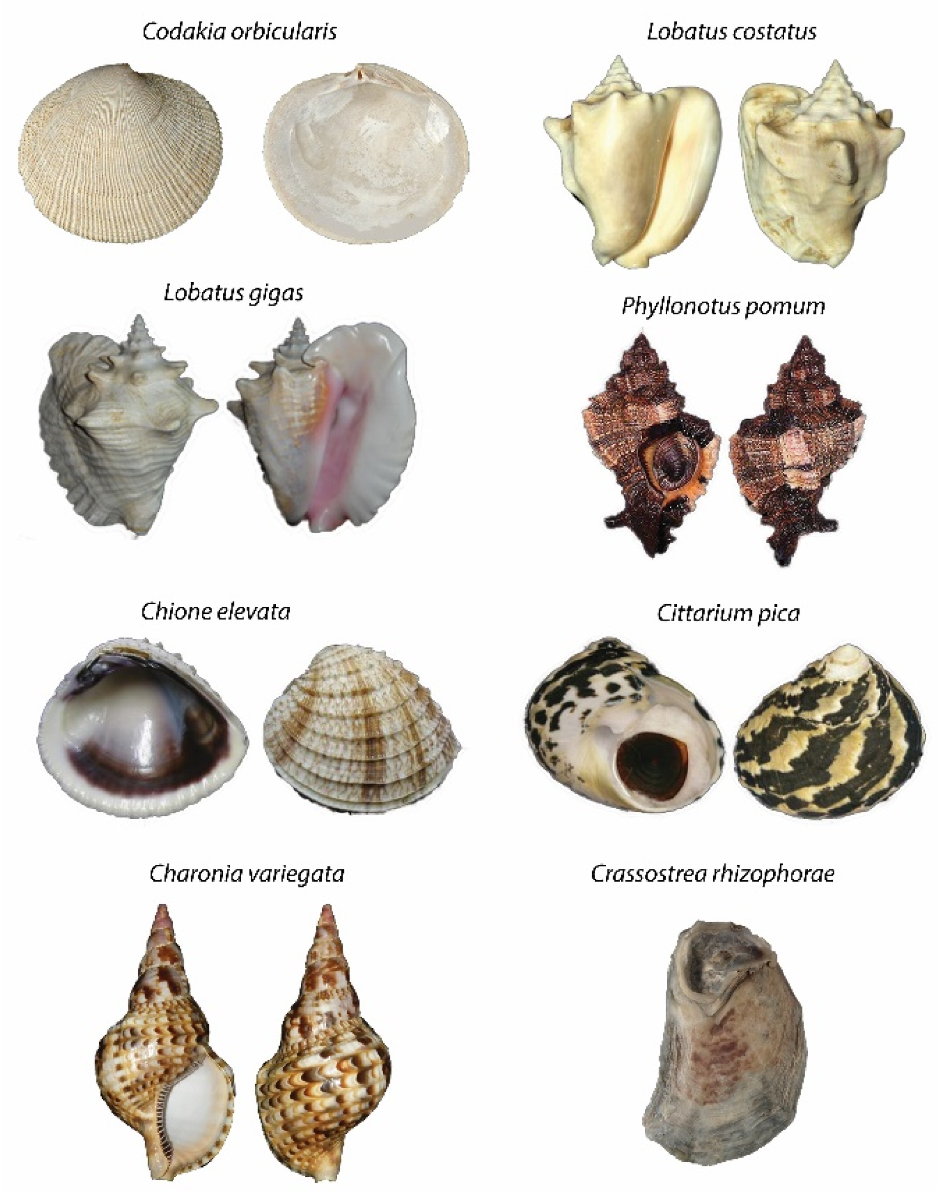
The regional archaeological pattern (Figure 2) in the Montecristi coastal area consists of four groups of archaeological sites. The first of these groups include the large habitation sites (>3 ha, n = 8), which are always located higher than 150 masl. All of these sites contained ceramics with Meillacoid (800–1550 AD) attributes as the main component, in association with ceramics from the Chicoid series (900–1700 AD) and a mixed ceramic component that includes stylistic attributes from the Meillacoid and Chicoid series (1000–1700 AD). These sites have a high diversity of lithic artefacts (axes, scrappers, flints, cores, hammerstones, and grinding stones) and a limited variety of shell objects (axes and scrapers). Most sites also showed a great assortment of mollusk shells, with a total of 17 species identified across the region, with 5 to 8 of these species recorded at each of the large habitation sites. The most common species at all sites were Codakia orbicularis sp., Lobatus costatus sp., and Lobatus gigas sp. (Figure 3). These sites are usually located over 1 km from water sources, while fewer are located at a distance less than 500 m.
The second class of sites includes medium-sized habitation sites (between 1 to 3 ha, n = 17), which are mostly located below 80 masl and with only a few between 100 to 200 masl. Most of these sites contain exclusively Meillacoid ceramics and only very limited numbers of lithic artefacts, mostly axes and/or hammer stones (usually 1 to 2 per site). The mollusk specimens are not diverse, with most sites containing 3 to 5 species. Unlike the previous category, these sites are usually located close to water sources (<500 m).
The third class of sites–the small habitation sites (<1 ha, n = 49)–do not show a specific pattern of elevation. At half of these sites, it was not possible to identify a specific ceramic affiliation as materials tend to be very fragmented and scarce. In the other half, mostly Meillacoid ceramics were registered, and in a few cases, together with Chicoid and mixed Meillacoid-Chicoid components. Stone artefacts were limited at these sites, with only one lithic artefact often recorded (usually an axe or a hammerstone). The same pattern generally held for shell artefacts, with only one artefact observed, in most cases, this was either a hammer or a gubia (a shell artefact used in woodworking and agriculture). In most of these sites, 1 to 3 species of mollusks were recorded.
The final category included is the resource exploitation sites (<3 ha). These sites are characterized by the absence of ceramics or other lithic and shell artefacts. They are exclusively located along the coastline and are usually very close to each other. This pattern suggested that, rather than defining them as sites, they should be perceived as “exploitation zones”. The material culture associated with these sites was very limited, comprising only a few ceramic sherds (either unidentified or Meillacoid) and lithic artefacts (either scrapers or flakes). The few shell artefacts recorded were perforators, gubias or hammers.
The preliminary interpretation of these results suggests that the large sites were permanent living places that formed a focus for daily activities. Based on the diversity of material culture present, such sites may have also served as locations where exchange networks were maintained at the local and possibly regional level. Second, the medium-sized sites seem to have been related to temporary or permanent housing activities and, given that both the material evidence and its diversity is less, they may have had fewer inhabitants or existed for shorter periods of time. As in neighboring areas, these medium sites also could have been related to specific activities such as agriculture or could have served as rancherías (small hamlets) for hunting parties or fishermen going to the coast [27]. Third, the small sites might have been related to specific tasks, possibly daily activities which recurred over time but that did not need to be done in exactly the same place (e.g., a location where marine products were processed once or multiple times before being transported to hamlets or the main settlement). The patterning of these sites highlights the dynamics and mobility of people in their landscape and the decisions related to this movement.
3. Discussion: Indigenous and Spanish Taskscapes
The taskscape concept is used here as a bridge to connect the materiality of the archaeological record with the abstract idea of landscape. In conceptual terms, this is rendered by using the taskscape as a layer within the complexity of the landscape [28]. A recent example of this was provided by Ingold [17] by using one of Brueghel’s paintings. This painting shows a sixteenth-century European settlement, with representations of people’s day-to-day activities being carried out in specific places within the town. From an archaeological perspective, this painting highlights three main aspects: the spatial relationships, the idea of spatial scale, and how they are used to define a place. Drawing on Ingold’s reading of this painting, it is clear that ‘place’ can refer to both the location where a specific task is being carried out as well as the entire town. For Ingold, a place is defined by the overlapping lines left by people’s movements through the world, in a process he defined as the meshwork of entangling lines [29]. If each location in the painting is the result of a person or a group of persons’ movement in the town and the world, each location (including the town) constitutes a place. Since Ingold’s definition would fits multiple scales, the idea of taskscape can be deemed multiscalar. Scale may not be an issue when working the idea of landscape in art or ethnography, since the observer in these disciplines has access to the whole “image”. In archaeology, however, the spatial scale is a challenge as considering different spatial scales for analysis will potentially result in different reconstructions and interpretations of past humans patterns within the landscape.
To minimize potential misinterpretation and biased classification, and following the idea that the taskscape forms a key level in the process of archaeological analysis, three spatial scales of taskscape were defined for the case study presented here, each of which relates to the tasks and movement of indigenous people in the past.
3.1. Small-Scale Taskscapes
The first scale where a set of tasks was identified was that of the site. Based on all of the previously-described size and functional categories, the primary activities at this scale are related to general domestic activities and the exploitation of land and sea resources, which include tasks of craft production, as well as agricultural, hunting, and fishing activities. This first level of the indigenous taskscape relates directly to daily activities, that is, with the decisions and actions at the level of local communities and their dwelling in the world. The general pattern reconstructed from this evidence is that there tends to be a large place (large-size sites) that can be associated with permanent areas of habitation and the common tasks of a settlement. These main settlements were “surrounded” by other places (medium and small-size sites and exploitation of sea resource sites) that were associated with highly specialized activities such as marine resource processing, lithic workshops and/or agricultural production. This whole combination of tasks constitutes the first layer of taskscape, and refers to the internal taskscape of each settlement or areas close to the main settlement.
3.2. Medium-Scale Taskscapes
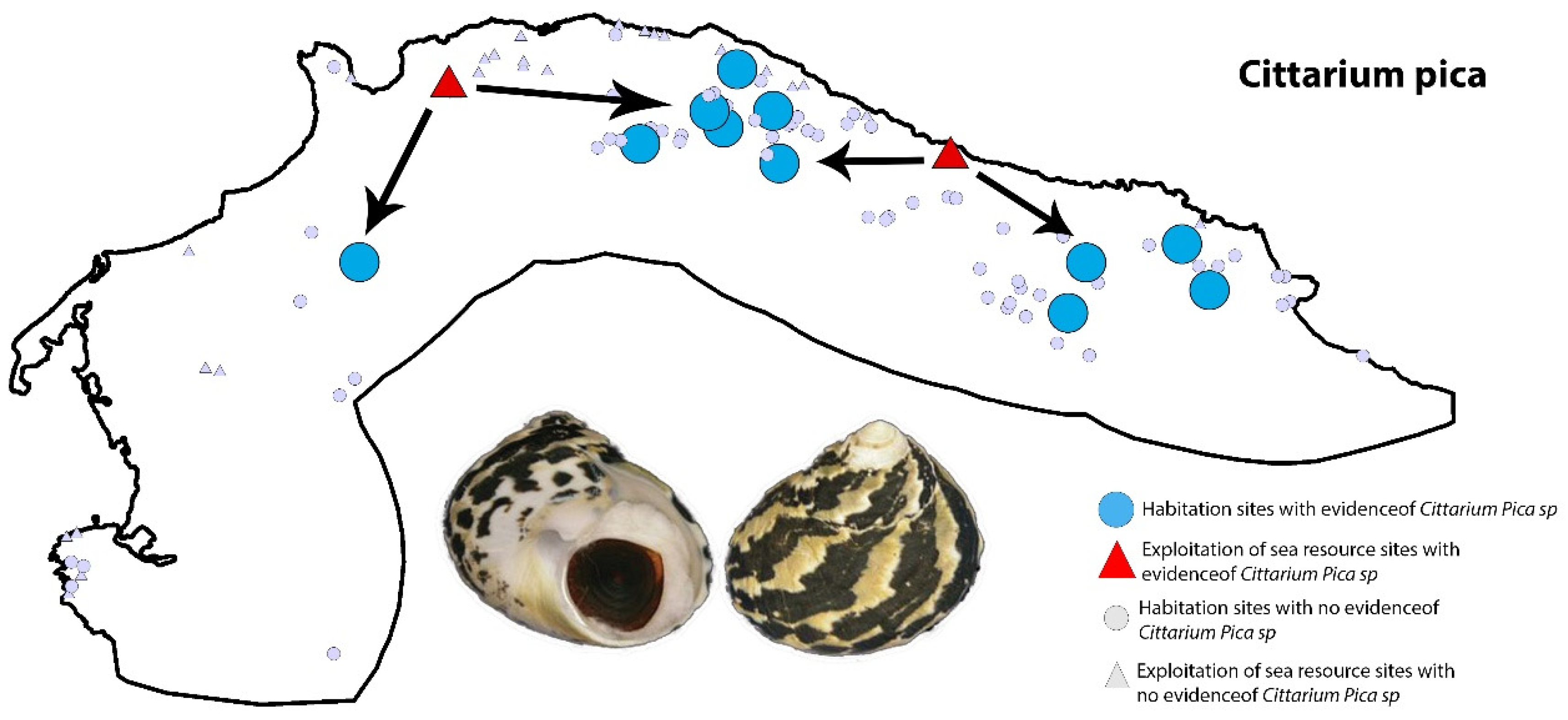
A second scale of the indigenous taskscape occurs at the level of the study area. At this scale, it was possible to identify tasks that interconnect most of the archaeological sites. For example, the presence of specific materials at particular sites, such as mollusk shells and lithic artefacts, indicate tasks related to specialized exploitation of marine resources. The presence of these same mollusks, however, at some of the larger settlements indicates their exchange and/or trade throughout the research area. This taskscape also suggests daily interactions between different communities from distant settlements (possibly between culturally different populations). Figure 4 shows a representation of the connections between particular sea resource sites where a specific mollusk shell-type was identified (in this case Cittarium pica, sp.) and the habitation settlements where that same type of shell was recorded. As can be inferred from the image, there seems to be a pattern of distribution and redistribution of the marine resources across larger zones of the study area.
3.3. Large-Scale Taskscapes
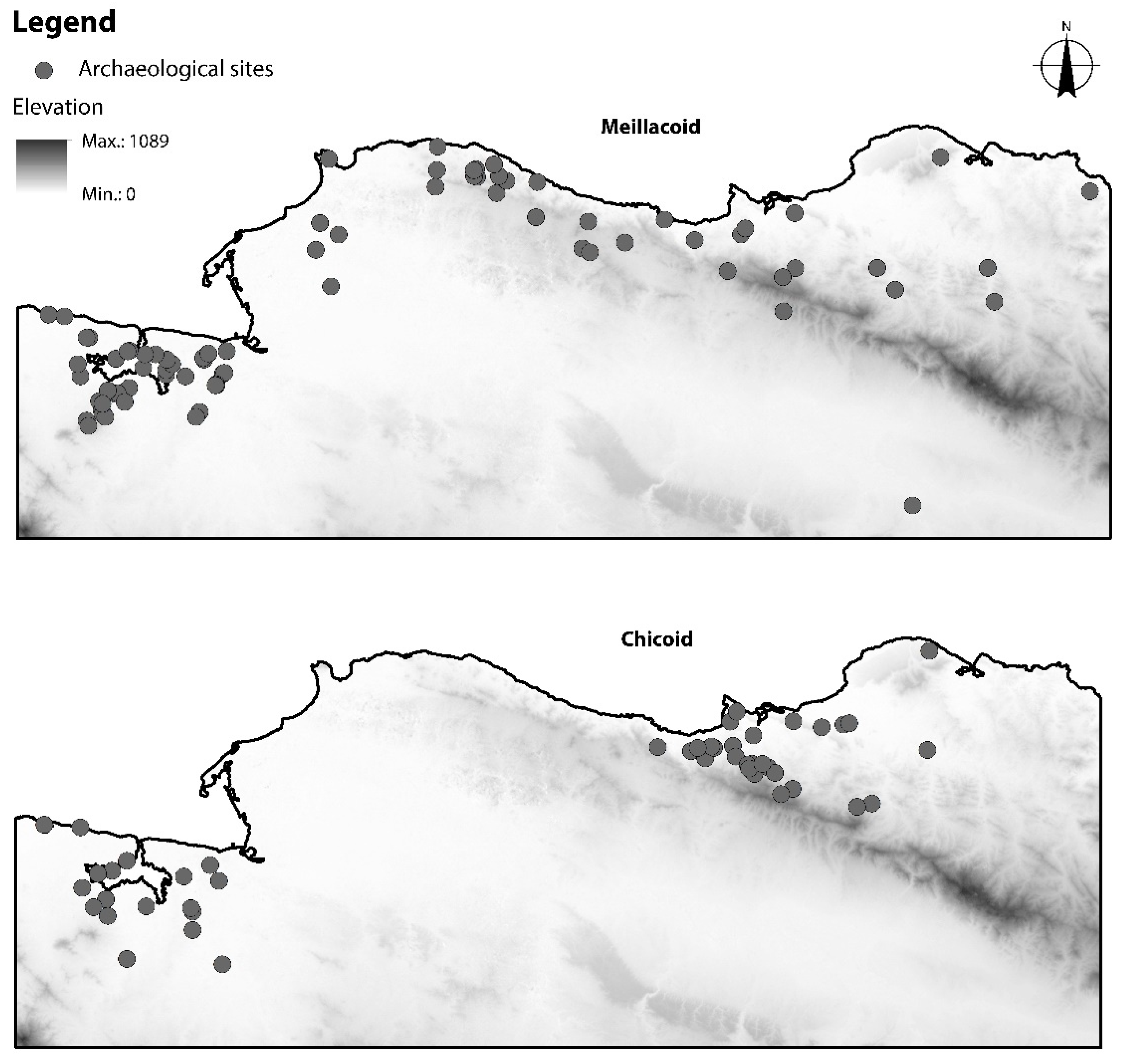
The third scale of the indigenous taskscape was defined when evaluating the regional distributions of the ceramic series present in the region. In the northern sector of the island, two ceramic series dating to the Late Ceramic Age (1100–1500 AD) and the early colonial period (1500–1600 AD) have been classified: Meillacoid and Chicoid [30,31,32,33]. The particular distribution pattern of the sites related to the Meillacoid ceramics between the coastal areas of the Montecristi province and the eastern province of Puerto Plata, as well as the characteristic distribution patterns of the Chicoid sites in the region, seem to highlight a political taskscape (Figure 5). This taskscape could have been based on the relationships and interactions between different communities and the rights to access certain areas. Socio-political and cultural reasons could be the main causes for the absence of sites with Chicoid ceramics in the area of the coast of Montecristi. The coastal area of Montecristi also has important topographic (its location at the end of the Cordillera Septentrional) and ecological features (endemic areas of the only mammals on the island, the hutia and solenodon, and easy access to the mangroves), which may have played a role in the interest of Meillacoid-using communities in maintaining control over this area and its resources. Alternatively, conflicts among indigenous groups could also have contributed to this particular pattern.
3.4. Indigenous Landscape
The indigenous landscape, that the early Spanish observed, can be reconstructed is composed of a variety of places and artefacts that indicate the diversity of activities carried out by past communities. The patterned distribution of places revealed the past inhabitants’ recurrent interests of interacting, exploiting and selecting activity places based on topography. The pattern is defined by “central” places related to habitation, trade and perhaps political centrality, followed by a series of medium to small places related to other non-domestic activities such as the exploitation/processing of marine resources, agriculture and, possibly, other activities such as logging and/or production of lithic artefacts. In addition, the non-domestic sites tend to afford the best visibility of the surroundings and marine environment, as has already been proposed for neighboring areas in the region [35,37,38]. These patterns are also observed in other neighboring research areas, such as the coastal region of the Puerto Plata province and northeastern Haiti, with some local particularities possibly related to the topography and culture of the different indigenous communities. The indigenous landscape before 1492 was dynamic and diverse, where communities seem to have shared similar cultural features that are evident across multiple scales. However, at the largest analytical scale, there are indications of cultural heterogeneity that might have resulted from ethnic differences, cultural territories and/or conflict relations.
3.5. Spanish Taskscapes
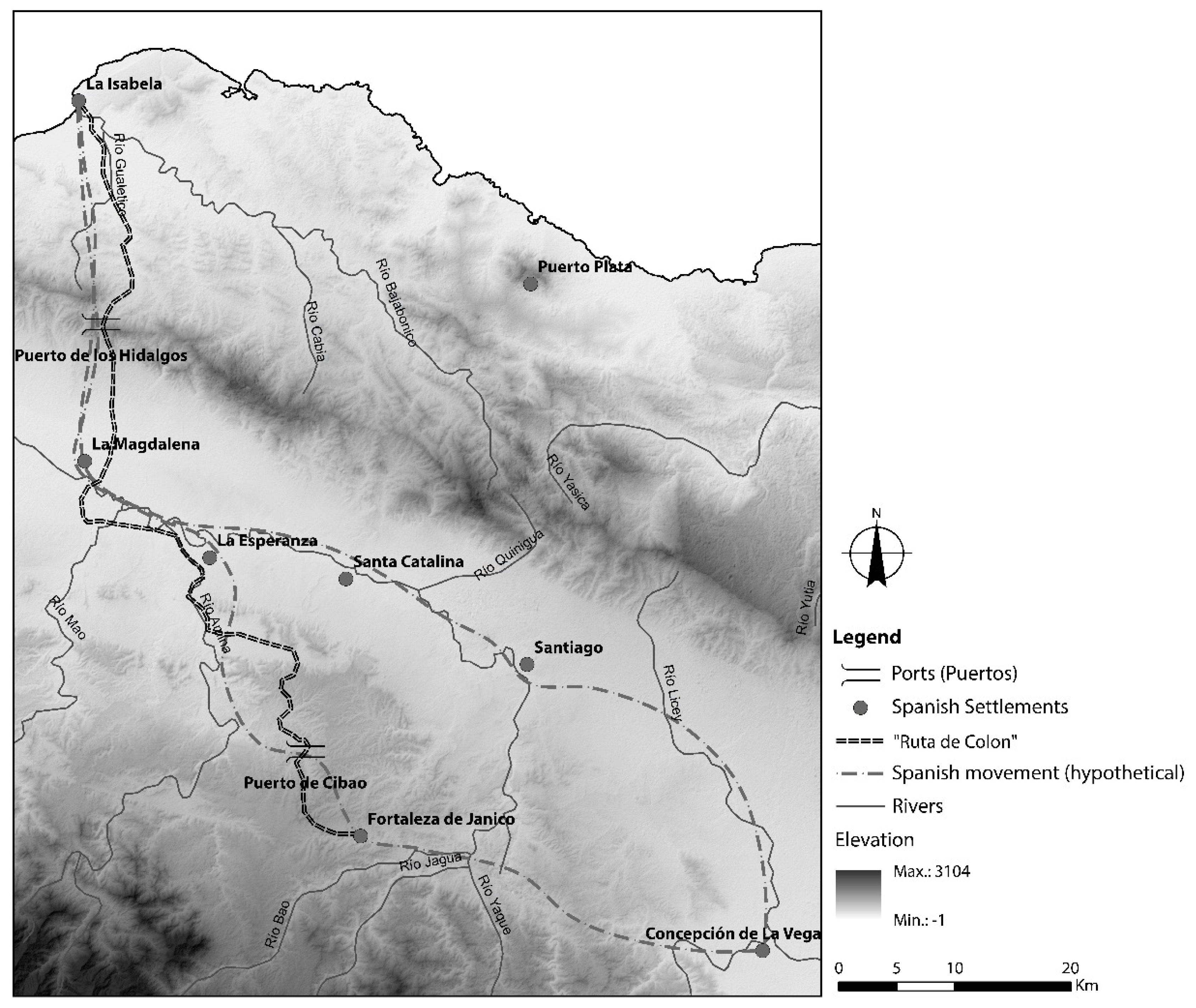
A good example of the Spanish movements during the early phase of colonization and that formed part of their strategies to reach the inland gold area and control of indigenous population is the so-called Ruta de Colón [39,40]. Figure 6 shows a reconstruction of this route as well as some hypothetic lines of the Spanish movements, based on the early chronicles reports. The figure also shows the location of the Spanish towns and forts, from the earliest town of La Isabela (1493) to the fort at Jánico (1494) where the gold mines were located. Following Ingold’s [16,29] definition of place, each fort and town formed a ‘node’ resulting from the repeated passage and selection of certain places as a consequence of the move from the coast to the mainland. In addition, the selection by the Spanish of those specific places for settlement responded to the several indigenous settlements that already existed along this route, as reported by the early chronicles [41,42,43,44]. The ‘lines’ created by the Spanish movement is evidence of their intentions to successfully exploit and transfer gold to the coast, as well as the need to dominate the territory and its people. The forts were built near resistant or important settlements of the indigenous groups. For example, the fort of La Magdalena was built in the Cibao valley, close to Los Hidalgos pass through the northern mountain range, within the area known by the indigenous people as the province of Macorís, and to the north of the supposed area of residence of Cacique Caonabo. Cacique is a word the indigenous people used to refer to their leaders. The early Spanish compare this term to that of king. This fort was destroyed by the indigenous people of the area and, shortly after, the Spanish replaced it with the fort of La Esperanza [43]. On the other hand, some Spanish towns were built near key natural resources (gold veins, rivers, coast) as well as near important indigenous settlements. For example, the town of Concepción de la Vega was founded near the settlement of Cacique Guarionex, with whom the Spanish initially had formed an alliance and later fought several fierce battles.
The initial colonial landscape was shaped by the exploitation of the island’s mineral and human resources through the factoría system [45]. This was a colonialist system originally developed in Portugal and applied to the Spanish in the conquest of the Canary Islands [46]. The Spanish landscape was made up of two taskscapes. One is based on the exploitation of resources and the other on the military control of the territory. These taskscapes allow an understanding of part of the Spanish logic in conquering the indigenous world, and represent elements of the transformation of the indigenous landscape into the Spanish colonial one during the first years of colonization. The Spanish landscape during these the first years on the island of Haytí was characterized by, in the first place, closely spaced settlements to aid the movement of troops and suppress the constant indigenous uprisings, such as the one that destroyed the fort of La Magdalena or the uprising of the caciques Guarionex and Mayobanex [41]. Second, these settlements, whether villages or forts, served as forms of control and domination of the local population and protected of the movement of resources between the inland and the coast.
Figure 6.
Spanish settlements and movements in the north of Haytí during the first years of colonization (approximate locations based on Sauer [47]).
Figure 6.
Spanish settlements and movements in the north of Haytí during the first years of colonization (approximate locations based on Sauer [47]).

4. Conclusion: The Transformation of the Indigenous Landscape
To fully understand the transformation of indigenous landscapes on northern Haytí, the regional archaeological patterns formed by indigenous taskscapes were compared to the regional patterns of movement and settlement of the early Spanish colonizers in the same study region. This comparison led to the idea that the transformation of the indigenous landscape can be explained on two analytical levels. These levels have been conceptualized as Day-to-day and Imaginary. The first explains the changes that occurred within the indigenous communities in terms of the tasks, practices and movements that characterized the quotidian indigenous taskscape before the arrival of the Spanish. The second level has to do with the representations developed by the first Spanish invaders of the indigenous world and how these representations themselves contributed to the transformation of the indigenous landscape.
4.1. Day-To-Day Level: Contested Taskscapes
One way to conceptualize the conquest of the indigenous world and its initial transformation is through the idea of contested taskscapes [22]. From the earliest years of colonization, the Spanish invaders depended on the local population to obtain basic products and resources. For example, beginning during the second voyage, Columbus imposed a tribute in gold and food on the indigenous people [41]. In the case of gold, indigenous populations were forced to carry out the task of mineral extraction at known gold veins and rivers, where, in general, the activity followed pre-invasion patterns. However, the intensity of this task radically changed, as did the reasons for the work, with indigenous people preferring to commit suicide and induce abortions to avoid the horrors of enslaved labor in the gold mines for themselves and their descendants [41,48]. In this sense, although the task remained the same and it was carried out in the same places, the taskscape, the constitutive acts of dwelling, changed radically and consequently a conflict was created.
In the case of food production, something similar happened. Even though the indigenous communities continued to produce food according to their traditional knowledge and practices in the usual places, there was a change in the motivation behind the execution of these same tasks. The Spanish demanded a quota greater than the one they were used to producing, leading to the occurrence of a conflict in the daily tasks that constituted the indigenous agricultural taskscape. An example of this was recorded in the early chronicles, when the cacique Guarionex tried to increased cassava production to pay the Spanish more ever a larger quota and lessen the aggression of the conquistadores. However, shortly after these negotiations, Guarionex would go to war with the Columbus brothers since his people had not been able to produce as much food as expected [41,42]. In addition, Guarionex and his people were affected by the Spanish presence near their towns and traditional areas as well as by the fear and rage instilled in them by witnessing what the Spanish were doing to other indigenous groups.
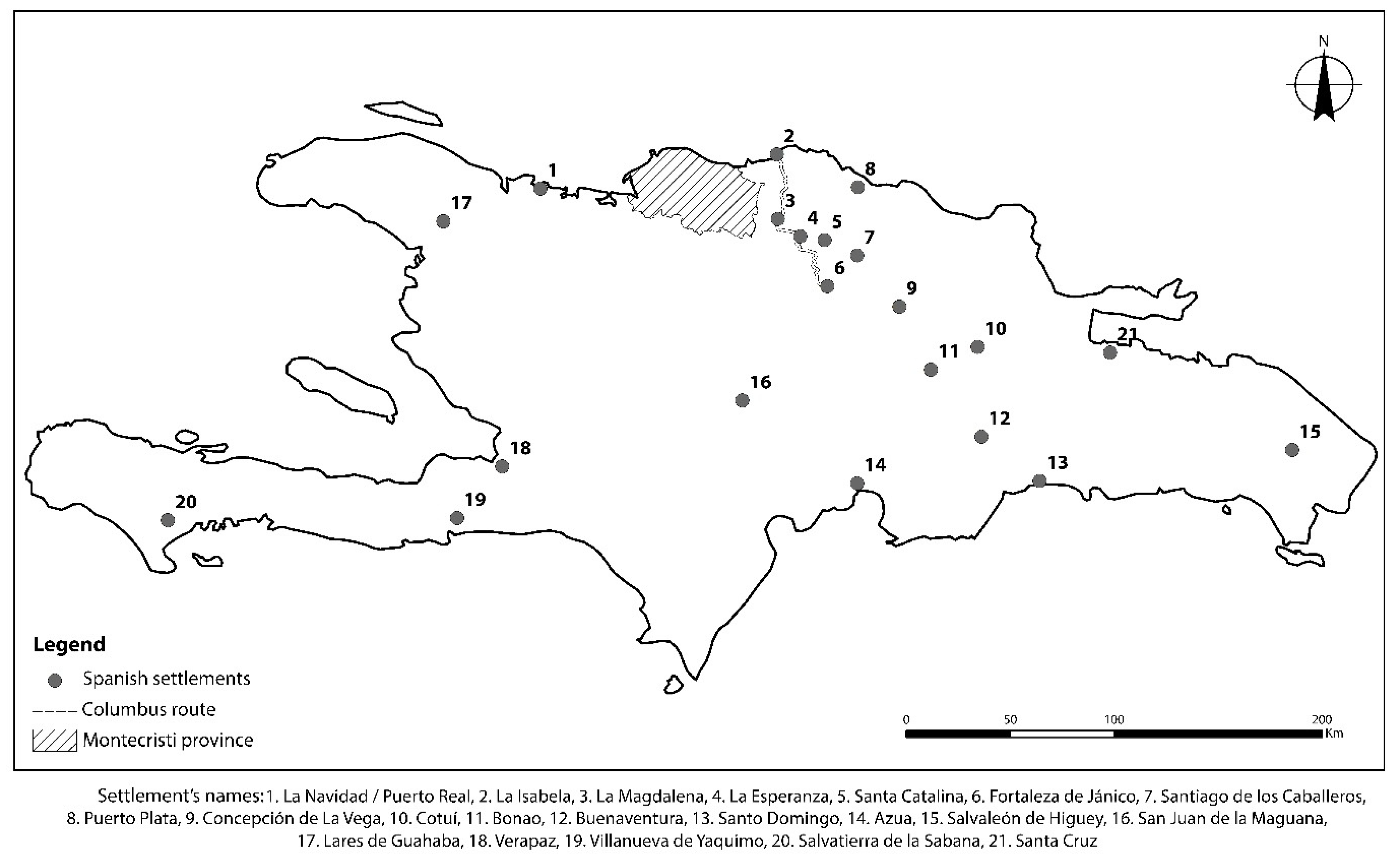
A third contested taskscape can be identified in the Spanish settlements along the island (Figure 7). When Nicolás de Ovando became governor of La Española (1502–1509), other mechanisms to deal with local populations and resources were implemented. By that time, the Spanish had moved to displacing entire communities to Spanish towns to continue fulfilling the tasks of food production and gold exploitation, as well as general servitude. As the people were “inserted” in the Spanish villages, in a process known as encomiendas y repartimientos [49], the new places where these tasks were to occur were far from where they traditionally took place. An archaeological example that supports the existence of these contested taskscapes comes from the province of Montecristi [26]. During the survey in this area, there was only one place where material culture related to the second half of the 16th-century was recorded, namely in the area where the original foundations of the villa of Montecristi (circa 1535) were located [50]. In the rest of the area, no evidence of early 16th-century European material culture was found. In fact, all Spanish or European materials postdate the 17th-century. This could be evidence that during the beginning of the conquest and colonization process (circa 1493 to 1502), the Spanish villages did not have rural areas, since their focus was on territorial access and control. After Columbus’s second voyage, the Spanish started their attempts to introduce European animals and vegetables to the island environment [51]. As a result of the food crisis in Spain and Portugal and the efforts of Nicolás de Ovando to improve the quality of the colony since 1502, Spanish efforts in cultivation had not fully started [51]. During the first decade of the colonization, the indigenous communities and their towns were the equivalent of the “countryside” for food production. As mentioned, the indigenous agricultural taskscapes were maintained in their traditional places, serving as rural areas for the Spanish, until the populations were displaced to the Spanish villages. This created a key space of contestation, and after several decades, helped to promote the creation of new creole rural communities.
Following this discussion, the idea of the contested taskscape can be connected with two levels of human experience. First, the physical level, which refers to the conflicts that occurred through the materiality of placemaking. For example, the establishment of Spanish forts and settlements close to important indigenous settlements. Second, the cognitive level, which refers to the perceptions of individuals and communities that live in and move between those places where physical conflict was manifest. For example, individuals and communities suffered a strong psychological impact when they become enslaved and had to continue exploiting resources that were known and familiar to them, in places that possibly carried deep cultural meanings. Bender has explained that studies of conflicts and diasporas generally focus on broad social and political scales “without too much consideration of what this might involve in terms of intimate and personal engagement” [23]. In this sense, when day-to-day tasks (the basis of the cultural skills and knowledge of an individual or of a community) were carried out under conditions of force and enslavery, this affected both the people’s perception of those tasks in themselves and their perception of the landscape where those tasks were carried out. This, in turn, would have generated both a personal conflict with the task in question and with the “constitutive acts of dwelling” [17], i.e., with the taskscape. With the development of the colonial state, the stress on indigenous people increased as they were continuously pressured to increase production, to accept new ideologies and religion, and finally to be integrated into the Spanish system as new subjects of a sovereign they did not choose. As Bender [24] has rightly expressed, “the mutual incomprehension engendered by totally different social, political and economic practices extends to include the inability to recognize or at least tolerate a completely different understanding of place and landscape.” The indigenous and Spanish taskscapes, at their different spatial scales, naturally came into direct conflict since their basic notions of nature, territory and ownership were radically different.
4.2. Level of the Imaginary: Historical Homogeneities and Archaeological Diversities
The second level concerns how the first Spanish invaders represented the indigenous people. The image created during the first decades of colonization not only transfigured the landscape and the indigenous world in the past but also did so for the future Caribbean populations that came into being with a distorted idea of the island of Haytí before 1492. This issue can be explored from two perspectives. The first concerns the invisibilization of indigenous communities and their presence in the landscape. The early chroniclers, whether due to the difficulty in understanding indigenous cultures or a lack of interest in deep descriptions, presented a vague image of the indigenous people. Based on their understanding of the world, the first Spanish tried to identify in the indigenous communities hierarchical and spatial patterns similar to those that existed in Europe at that time. In spatial terms, this led to the definition of indigenous “territories” [52] that, based on the available archaeological evidence from the northern region of the island [26,27,34,35,53,54], do not seem to reflect the cultural diversity or the political organization before 1492.
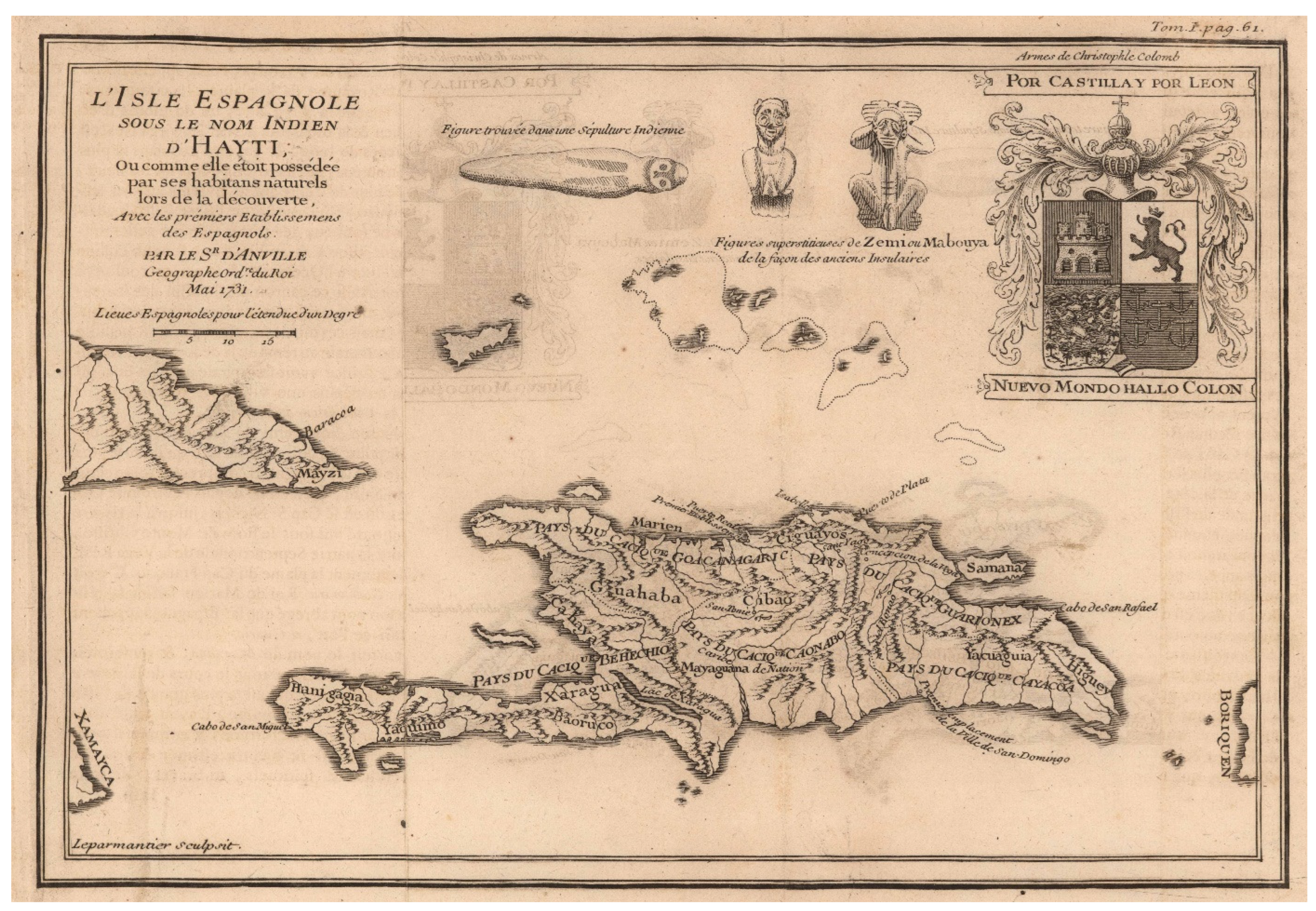
An example of this comes from the 1516 map of Andrés de Morales (Figure 8), which divided the island into five regions. While a subsequent report by Peter Martyr d’Anghiera [48] based on Morales’ report and map described these as natural regions, the 20th-century economist Bernardo Vega [52] interpreted these regions as political territories related to the indigenous cacicazgos (chiefdoms). However, the map of Morales does not depict borders between these territories and Martyr d’Anghiera simply states that: “The pilot Morales, brings me a new description that from time immemorial the indigenous people used.” [48]. The evidence from both the map and the documentary record does not suggest that this description included the delimitation of chiefdoms, as later proposed by Vega [52]. Indeed, the claim that these natural geographical regions which probably were imbued with cultural and historical meanings represented chiefly territories effaced, rather than explained, indigenous diversity. Nevertheless, the wider idea of indigenous territories connected to hierarchical political structures was present in several colonial chronicles and was finally depicted in Charlevoix’s map in 1731 (Figure 9).
Without doubting the existence of hierarchical societies on the island, it is important to recognize that the representation of homogeneous indigenous territories (i.e., one cacique (king) controlling one large territory (nation)) facilitated the explanation of indigenous cultural complexity for initial colonial observers. By contrast, the archaeological data, in combination with the different indigenous taskscapes defined here, reveal a diverse indigenous landscape shaped by multiple spatial scales of community interaction. This patterning is suggestive of the presence of multi-ethnic and politically centralized groups at small scales, rather than large cacicazgos occupying large and homogeneous territories. The first transformation of the indigenous landscapes of Haytí, therefore, happened at this level of Spanish colonial representation. The resulting image of homogeneous territories controlled by highly centralized political polities obscured the island’s multiple scales of interaction, the reality of which has been recovered only recently by archaeological research.
A second transformation of the indigenous landscape occurred with the eradication of the diversity of communities by creating homogeneous ethnicities. This point is detailed here through the example of the ethnonym “Taíno”. Several authors have highlighted that the early Spanish merged together a wide range of ethnic groups in the island of Haytí since they were unable to recognize internal cultural differences [56]. The Taíno are the classic example of this since they have been identified as the major indigenous group in the Greater Antilles [57,58]. However, Caribbean researchers have realized that, in order to do justice to the complexity of these ethnic groups without obscuring their cultural dynamics, terms such as “Tainoness” [56,59,60] or symbolic reservoir [61] are more appropriate to characterize the indigenous culture of these communities.
The first reference to the term Taíno was made on Columbus’s second voyage when upon arriving on the beach of an island he was greeted by people shouting “Taíno, Taíno”. The meaning of this word has been identified as “good” or “noble” [60,61,62]. In the 19th-century, the term Taíno began to be applied to define a particular ethnic group and to their language. The first reference to Taíno as the equivalent of an ethnic group that inhabited the Greater Antilles has been attributed to Rafinesque in 1836 [60], although the term was also used a few years later by Martinus in 1867 [61]. In 1871, Brinton used the term Taíno to describe the linguistic classification of the Arawak language spoken in those islands [62]. The popularization of the term Taíno was a consequence of the historical reconstructions that took place throughout the 19th-century, which condensed the previous generalizations and homogenizations of the ethnic and linguistic diversities of the indigenous groups of the northern Caribbean. For example, in his report about his coexistence with the indigenous people from the northern region of Haytí, Fray Ramón Pané mentioned that he was first sent by Columbus to live in the province of Macorís, where the fort of La Magdalena fort was located, and then to move and live with the cacique Guarionex, because this cacique and his people spoke a language that was understood throughout the island [43]. Still, Pané did not indicate whether Macorís was an ethnic group or that Guarionex and his language were Taíno. The idea that Guarionex was a Taíno cacique first appeared in the 19th-century historical reconstructions and was further consolidated in archaeological and historical scholarship in the 20th-century. The meaning of Macorís, as a language or ethnic unit, is still strongly debated among specialists.
The criticism raised by recent scholars in their quest to clarify the indigenous patterns before the arrival of Europeans parallels the foregoing critique of colonial cartographic depictions. The representations of indigenous communities made by the early colonizers and missionaries were deeply marked by a European understanding and classification of the world. This “environmental orientalism” [63] was a perspective that originated in the Middle Ages, and shaped how indigenous people were seen. The radically different ways of classifying and understanding the world by indigenous and Spanish groups is perhaps best exemplified in the simplicity with which the Spanish represented the indigenous world and its landscapes. In summary, through their process of interpreting it, the Spanish and other European colonists would transform the diverse, multi-ethnic and pluri-linguistic indigenous landscape into a homogenous “indigenous” landscape characterized by a limited set of homogenous ethnic groups and their territories. This early distorted vision which helped transform the indigenous landscape in the early colonial period, would be reaffirmed by 18th- and 19th-century naturalists, and more recently, further reinforced by archaeological models in the 20th century.
Funding
This research has received funding from the European Research Council under the European Union’s Seventh Framework Programme (FP7/2007–2013)/ERC grant agreement n° 319209, under the direction of Corinne L. Hofman (Leiden University, The Netherlands).
Institutional Review Board Statement
Not applicable.
Informed Consent Statement
Not applicable.
Data Availability Statement
The Montecristi data discussed in this paper is openly available on the EASY DANS repository at https://doi.org/10.17026/dans-xyn-cu72 accessed on 3 March 2022. Detailed information on the archaeological methodologies for data collection and processing is also available on open access [23].
Acknowledgments
Many thanks to the communities of the Montecristi province for their collaboration in this research. Thanks in particular to Rami Ramírez, Richard Peña, Eliecer Tati, Natividad Olivo, Abel González, Elvio González, Carlitos Peña, and Jaime Torres. The author also acknowledges the institutions that contributed with permissions, resources and funding: the Museo del Hombre Dominicano, Ministerio de Cultura de la Republica Dominicana, Ministerio de Medio Ambiente y de los Recursos Naturales, Ministerio de Ingeniería y Minas, Museo de Historia de Montecristi, Instituto Montecristeño de Antropología e Historia, European Research Council, and Leiden University. Finally, to Noa Corcoran-Tadd for his valuable comments on the manuscript.
Conflicts of Interest
The author declares no conflict of interest.
References
- Binford, L.R. Willow Smoke and Dogs’ Tails: Hunter-Gatherer Settlement Systems and Archaeological Site Formation. Am. Antiq. 1980, 45, 4–20. [Google Scholar] [CrossRef] [Green Version]
- Tilley, C. A Phenomenology of Landscape. Places, Paths and Monuments; Berg: Oxford, UK, 1994. [Google Scholar]
- Olwig, K.R. Recovering the Substantive Nature of Landscape. Ann. Assoc. Am. Geogr. 1996, 86, 630–653. [Google Scholar] [CrossRef]
- Ingold, T. The Perception of the Environment: Essays on Livelihood, Dwelling and Skill; Routledge: London, UK, 2000. [Google Scholar]
- Anschuetz, K.F.; Wilshusen, R.H.; Scheick, C.L. An Archaeology of Landscapes: Perspectives and Directions. J. Arch. Res. 2001, 9, 157–211. [Google Scholar] [CrossRef]
- Hicks, D.; McAtackney, L. Introduction: Landscapes as Standpoints. In Envisioning Landscape: Situations and Standpoints in Archaeology and Heritage; Hicks, D., McAtackney, L., Fairclough, G., Eds.; Left Coast Press, Inc.: Walnut Creek, CA, USA, 2007; pp. 13–29. [Google Scholar]
- Cosgrove, D. Geography and Vision. Seeing, Imagining and Representing the World; I. B. Tauris & Co Ltd.: London, UK, 2008. [Google Scholar]
- Descola, P. Beyond Nature and Culture; The University of Chicago Press: Chicago, IL, USA, 2013. [Google Scholar]
- Gosden, C.; Green, C.; Cooper, A.; Creswell, M.; Donnelly, V.; Franconi, T.; Glyde, R.; Kamash, Z.; Mallet, S.; Morley, L.; et al. English Landscapes and Identities: Investigating Landscape Change from 1500 BC to AD 1086; Oxford University Press: Oxford, UK, 2021. [Google Scholar]
- Gosden, C.; Head, L. Landscape–A Usefully Ambiguous Concept. Archaeol. Ocean. 1994, 29, 113–116. [Google Scholar] [CrossRef]
- Binford, L.R. The Archaeology of Place. J. Anthropol. Archaeol. 1982, 1, 5–31. [Google Scholar] [CrossRef]
- Thomas, J. The politics of vision and the archaeologies of landscape. In Landscape. Politics and Perspectives; Bender, B., Ed.; Berg: Providence, RI, USA, 1993; pp. 19–48. [Google Scholar]
- Bender, B. Stonehenge: Making Space; Berg, Bloomsbury Academic: Oxford, UK, 1998. [Google Scholar]
- Barrett, J.C.; Ko, I. A phenomenology of landscape: A crisis in British landscape archaeology? J. Soc. Archaeol. 2009, 9, 275–294. [Google Scholar] [CrossRef]
- Ingold, T. The temporality of the landscape. World Archaeol. 1993, 25, 152–174. [Google Scholar] [CrossRef]
- Ingold, T. Being Alive. Essays on Movement, Knowledge and Description; Routledge: London, UK, 2011. [Google Scholar]
- Ingold, T. Taking taskscape to task. In Forms of Dwelling. 20 Years of Taskscapes in Archaeology; Rajada, U., Mills, P., Eds.; Oxbow: Oxford, UK, 2017; pp. 16–27. [Google Scholar]
- Herrera Malatesta, E. On contested taskscapes. In The creation of Landscapes: Borders, Movement and Conflicts; Herrera Malatesta, E., Borck, L., Eds.; unpublished book.
- Bender, B. Landscapes on-the-move. J. Soc. Archaeol. 2001, 1, 75–89. [Google Scholar] [CrossRef]
- Bender, B. Place and Landscape. In Handbook of Material Culture; Tilley, C., Keane, W., Küchler, S., Rowlands, M., Spyer, P., Eds.; Sage: London, UK, 2006; pp. 303–314. [Google Scholar]
- Bender, B.; Winer, M. (Eds.) Contested Landscapes: Movement, Exile and Place; Berg: Oxford, UK, 2001. [Google Scholar]
- Herrera Malatesta, E. Una Isla, Dos Mundos. Estudio Arqueológico Sobre el Paisaje Indígena de Haytí y su Transformación al Paisaje Colonial de La Española (1200–1550); Sidestone Press: Leiden, The Netherlands, 2018. [Google Scholar]
- Logan, A.L.; Dores Cruz, M. Gendered Taskscapes: Food, Farming, and Craft Production in Banda, Ghana in the Eighteenth to Twenty-first Centuries. Afr. Archaeol. Rev. 2014, 31, 203–231. [Google Scholar] [CrossRef]
- Antczak, A.; Antczak, K.A.; Antczak, M.M. Risky business: Historical archaeology of the Dutch salt enterprise on La Tortuga Island, Venezuela (1624-38). Post-Mediev. Archaeol. 2015, 49, 189–219. [Google Scholar] [CrossRef] [Green Version]
- Michelaki, K.G.; Braun, V.; Hancock, R.G.V. Local Clay Sources as Histories of Human–Landscape Interactions: A Ceramic Taskscape Perspective. J. Archaeol. Method Theory 2015, 22, 783–827. [Google Scholar] [CrossRef]
- Rajada, U.; Mills, P. Forms of Dwelling. 20 Years of Taskscapes in Archaeology; Oxbow: Oxford, UK, 2017. [Google Scholar]
- Ulloa Hung, J.; Herrera Malatesta, E. Investigaciones Arqueológicas en el Norte de la Española, entre viejos esquemas y nuevos datos. Boletín Mus. Hombre Dominic. 2015, 46, 75–107. [Google Scholar]
- Thomas, J. Concluding Remarks: Landscape, taskscape, life. In Forms of Dwelling. 20 Years of Taskscapes in Archaeology; Rajada, U., Mills, P., Eds.; Oxbow: Oxford, UK, 2017; pp. 268–279. [Google Scholar]
- Ingold, T. Lines. A Brief History; Routledge: London, UK, 2007. [Google Scholar]
- Rouse, I. Prehistory in Haiti: A Study in Method; Yale University Press: New Haven, CT, USA, 1939. [Google Scholar]
- Rouse, I. Migrations in Prehistory. Inferring Population Movement from Cultural Remains; Yale University Press: New Haven, CT, USA, 1986. [Google Scholar]
- Veloz Maggiolo, M.; Ortega, E.; Fuentes, A.C. Los Modos de Vida Mellacoides y sus Posibles Orígenes. Un Estudio Interpretativo; Museo del Hombre Dominicano: Santo Domingo, República Dominicana, 1981. [Google Scholar]
- Ortega, E.J. Compendio General Arqueológico de Santo Domingo; Academia de Ciencias de la República Dominicana: Santo Domingo, República Dominicana, 2005; Volume I. [Google Scholar]
- Moore, C.; Tremmel, N. Settlement patterns in Pre-Columbian Haiti: An Inventory of Archaeological Sites. 1997, p. 156. Available online: http://ciat.bach.anaphore.org/archives/show/HTIGOUVCIAT_ETU_Amenagement_de-209 (accessed on 22 September 2021).
- Ulloa Hung, J. Arqueología en la Línea Noroeste de La Española. Paisajes, Cerámicas e Interacciones; Instituto Tecnológico de Santo Domingo: Santo Domingo, República Dominicana, 2014. [Google Scholar]
- Herrera Malatesta, E.; Hofman, C.L. Indigenous Landscape Transformation on Northern Haytí: An Archaeological and Environmental Database of the Montecristi Coast. J. Open Archaeol. Data 2019, 7, 1–5. [Google Scholar] [CrossRef]
- De Ruiter, S. Mapping History: An analysis of site locations in the northwestern Dominican Republic. Master’ Thesis, Leiden University, Leiden, The Netherlands, 2012. [Google Scholar]
- Ransijn, S. The (Re)construction of Ancient Indigenous Landscapes through Visibility Analyses. Analysing visibility patterns from multiple viewsheds during the Late Ceramic Age (AD 800–1500) in the coastal zone of the Montecristi Province, Dominican Republic. Undergraduate Thesis, Leiden University, Leiden, The Netherlands, 2017. [Google Scholar]
- Morrison, S.E. Admiral of the Ocean Sea. A life of Christopher Columbus; Little, Brown and Company: Boston, MA, USA, 1942; Volume II. [Google Scholar]
- Ortega, E.J. La Isabela y la Arqueología en la Ruta de Colón; Ediciones de la Universidad Central del Este: Santo Domingo, República Dominicana, 1988. [Google Scholar]
- De Las Casas, B. Breve Relación de la Destrucción de las Indias Occidentales; Juan, F., Ed.; Hurtel: Filadelfia, PA, USA, 1821. [Google Scholar]
- De Las Casas, B. Historia de las Indias; Imprenta de Miguel Ginesta: Madrid, Spain, 1875. [Google Scholar]
- Pané, F.R. Relación acerca de las antigüedades de los indios. In Fray Ramón Pané: Relación Acerca de las Antigüedades de los Indios; Arrom, J.J., Ed.; Siglo XXI Ediciones: Ciudad de México, Mexico, 2001; pp. 1–49. [Google Scholar]
- De Oviedo y Valdés, G.F. Historia General y Natural de las Indias, Islas y Tierra-Firme del Mar Océano; Imprenta de la Real Academia de la Historia: Madrid, Spain, 1851. [Google Scholar]
- Moya Pons, F. The Dominican Republic. A National History; Markus Wiener Publishers: Princeton, NJ, USA, 2010. [Google Scholar]
- Cassá, R. Indios de las Antillas; Ediciones Abya-Yala: Quito, Ecuador, 1995. [Google Scholar]
- Sauer, C.O. The Early Spanish Main; University of California Press: Berkeley, CA, USA, 1966. [Google Scholar]
- Martyr d’Anghiera, P. Décadas del Nuevo Mundo, por Pedro Mártir de Anglería, Primer Cronista de Indias; Jose Porrua e Hijos Sucs.: Ciudad de México, Mexico, 1964. [Google Scholar]
- Mira Caballos, E. El Indio Antillano. Repartimiento, Encomienda y Esclavitud (1492–1542); Muñoz Moya Editor: Sevilla, Spain, 1997. [Google Scholar]
- Ortega, E.J. Ensayo Histórico y Arquitectónico de la Ciudad de Montecristi; Museo del Hombre Dominicano, Fundación Ortega Alvarez, Inc.: Santo Domingo, República Dominicana, 1987. [Google Scholar]
- Del Río Moreno, J. Los Inicios de la Agricultura Europea en el Nuevo Mundo; Academia Dominicana de la Historia: Santo Domingo, República Dominicana, 2012. [Google Scholar]
- Vega, B. Los Cacicazgos de la Hispaniola; Fundación Cultural Dominicana: Santo Domingo, República Dominicana, 1990. [Google Scholar]
- Koski-Karell, D.A. Prehistoric Northern Haiti: Settlement in Diachronic Ecological Context. Ph.D. Thesis, The Catholic University of America, Washington, DC, USA, 2002. [Google Scholar]
- Jean, J.S. La Biographie d’un Paysage. Etude sur les Transformations de Longue Durée du Paysage Culturel de la Région de Fort-Liberté, Haïti; Sidestone Press: Leiden, The Netherlands, 2019. [Google Scholar]
- Frati, C. El Mapa Más Antiguo de la Isla de Santo Domingo (1516) y Pedro Mártir de Anglería; Leo S. Olschki Editore: Firenze, Italy, 1929. [Google Scholar]
- Rodríguez Ramos, R. Rethinking Puerto Rican Precolonial History; The University of Alabama Press: Tuscaloosa, AL, USA, 2010. [Google Scholar]
- Granberry, J.; Vescelius, G.S. Languages of the Pre-Columbian Antilles; The University of Alabama Press: Tuscaloosa, AL, USA, 2004. [Google Scholar]
- Wilson, S.M. The Archaeology of the Caribbean; Cambridge University Press: Cambridge, UK, 2007. [Google Scholar]
- Rodríguez Ramos, R. Puerto Rican precolonial history etched in stone. Ph.D. Thesis, University of Florida, Gainesville, FL, USA, 2007. [Google Scholar]
- Oliver, J.R. Caciques and Cemí Idols: The Web Spun by Taíno Rulers between Hispaniola and Puerto Rico; University of Alabama Press: Tuscaloosa, AL, USA, 2009. [Google Scholar]
- Curet, L.A. The Taíno: Phenomena, Concepts, and Terms. Ethnohistory 2014, 61, 467–495. [Google Scholar] [CrossRef]
- Keegan, W.F.; Hofman, C.L. The Caribbean before Columbus; Oxford University Press: New York, NY, USA, 2017. [Google Scholar]
- Pálsson, G. Human-Environmental Relations: Orientalism, Paternalism and Communalism. In Nature and Society: Anthropological Perspectives; Descola, P., Pálsson, G., Eds.; Routledge: New York, NY, USA, 1996; pp. 63–81. [Google Scholar]
Figure 1.
The province of Montecristi (Dominican Republic) in the context of the contemporary Caribbean.
Figure 1.
The province of Montecristi (Dominican Republic) in the context of the contemporary Caribbean.

Figure 2.
Registered archaeological sites in the coast of Montecristi, Dominican Republic.

Figure 3.
Most common mollusk shells registered on the research area.

Figure 4.
Ideal representation of medium-scale taskscapes.

Figure 5.
Large-scale taskscapes. Ceramic series distribution pattern: (above) Meillacoid, (below) Chicoid. The data for this image comes from [27,34,35,36].

Figure 7.
Distributions of early Spanish settlements.

Figure 8.
Map of Haytí during the early colonial period by Andres de Morales in 1516 (taken from Frati [55]).
Figure 8.
Map of Haytí during the early colonial period by Andres de Morales in 1516 (taken from Frati [55]).

Figure 9.
Map of Haytí showing the supposed indigenous territories by Pierre-Francois-Xavier de Charlevoix in 1731 (courtesy of the digital collection of John Carter Brown Library at Brown University).
Figure 9.
Map of Haytí showing the supposed indigenous territories by Pierre-Francois-Xavier de Charlevoix in 1731 (courtesy of the digital collection of John Carter Brown Library at Brown University).

Publisher’s Note: MDPI stays neutral with regard to jurisdictional claims in published maps and institutional affiliations. |
© 2022 by the author. Licensee MDPI, Basel, Switzerland. This article is an open access article distributed under the terms and conditions of the Creative Commons Attribution (CC BY) license (https://creativecommons.org/licenses/by/4.0/).
Share and Cite
MDPI and ACS Style
Herrera Malatesta, E. The Transformation of Indigenous Landscape in the First Colonized Region of the Caribbean. Land 2022, 11, 509. https://doi.org/10.3390/land11040509
AMA Style
Herrera Malatesta E. The Transformation of Indigenous Landscape in the First Colonized Region of the Caribbean. Land. 2022; 11(4):509. https://doi.org/10.3390/land11040509
Chicago/Turabian StyleHerrera Malatesta, Eduardo. 2022. "The Transformation of Indigenous Landscape in the First Colonized Region of the Caribbean" Land 11, no. 4: 509. https://doi.org/10.3390/land11040509
Note that from the first issue of 2016, this journal uses article numbers instead of page numbers. See further details here.