Article

Rainfall Erosivity Impact on Sustainable Management of Agricultural Land in Changing Climate Conditions

by
Bořivoj Šarapatka
* and
Marek Bednář
Department of Ecology and Environmental Sciences, Palacký University, Šlechtitelů 27, 783 71 Olomouc, Czech Republic
*
Author to whom correspondence should be addressed.
Land 2022, 11(4), 467; https://doi.org/10.3390/land11040467
Submission received: 28 February 2022 / Revised: 14 March 2022 / Accepted: 21 March 2022 / Published: 24 March 2022
(This article belongs to the Special Issue Land: 10th Anniversary)

Abstract

:
Soil is negatively affected by many degradation factors, of which soil erosion is the most serious, affecting soil quality, crop production, and environmental components. Soil quality is an issue dealt with in the New European Green Deal. In order to meet the set goals, it will be necessary to address soil degradation and water erosion in the agricultural landscape, and increase the area of green infrastructure within the landscape (e.g., fragments of woodland, windbreaks, and grassland). In this context, climate change is also expected to affect the frequency and intensity of torrential rainfall, leading to increased runoff, reduced infiltration, and greater soil loss. Therefore, in this study, we have elaborated the issue of agricultural landscape and erosion, looking at erosion control measures necessary in dealing with existing erosion processes in an intensively farmed area with chernozem soils, and compared these with scenarios assumed for 2050. In these future scenarios, the commonly applied agrotechnical measures will not suffice to keep soil loss at a tolerable level. In the future, it will be necessary to discuss a further reduction in the size of land blocks, with the inclusion of green infrastructure in the landscape. In addition to solving problems of erosion, this would increase diversity in the area and enable sustainable agricultural management.

1. Introduction

Human society is dependent on the Earth’s diverse soil resources, which, however, tend to be significantly affected by human activity [1]. The negative effects on the soil are documented in many international studies, which also state that the majority of the world’s soil resources are only in fair, poor, or very poor condition [2]. Soil is negatively affected by many degradation factors, among which soil erosion is the greatest threat to soil fertility and productivity. When organic matter and nutrients are removed, plant growth is restricted, biodiversity is negatively affected, etc. [3]. Erosion causes a change in the physical, chemical, and biological properties of the soil, which also raises food security concerns for a growing world population [2,4].
The condition of soil resources may also be affected by climate change in the future. As reported by the Intergovernmental Panel on Climate Change (IPCC), future climate change may also accelerate soil erosion, thus affecting crop yield and food stability [5]. Climate change is thought to affect the landscape by torrential rainfall with increasing erosion, reduced infiltration, and greater soil loss [6,7,8].
These reasons also led to the adoption of the New European Green Agreement, which aims to make Europe, under the European Union, the first climate-neutral continent by 2050. The Green Deal, heavily debated at present, is an integral part of the Commission’s strategy to implement the United Nations’ 2030 Agenda and the sustainable development goals [9].
However, this requires numerous measures, so the European Commission has unveiled many solutions increasing the scope of protected areas and organically managed land, reducing soil degradation, etc. The aim of the Common Agricultural Policy (CAP) is the production of food with minimal negative effects on the environment. The key role in this is played by the soil, where it will be necessary to address the main degradation processes described in many publications, e.g., [10,11]. A very serious degradation process affecting the quality of soils, production, and components of the environment is the aforementioned erosion of soil, especially water erosion, which currently causes losses 1.6 times higher on all soils, or 2 times higher on agricultural land, than the formation of these soils [12]. The estimated surface area of EU-27 land affected by water erosion is 130 million ha [13,14]. The mean EU soil loss rate on agricultural land, forest, and semi-natural areas was found to be 2.46 t ha−1 year−1 [15]. The current assessment shows that 25% of EU land has an erosion rate higher than the recommended sustainable threshold (2 t ha−1 year−1) and more than 6% of agricultural land suffers from severe erosion (11 t ha−1 year−1) [16].
Such intensive soil loss also occurs in the fertile chernozem areas of South Moravia we are analyzing, where research on erosion processes is carried out on many sites and corrective measures are proposed. These proposals respect existing methodologies, and land-use changes that may occur in the context of climate change in specific agricultural production areas are not known today. The presented study aims to evaluate the current state of erosion processes and the applied erosion control measures in a selected model area, reflecting average conditions from the production/erosion point of view for a large chernozem region of South Moravia (CZ). These will be compared with future scenarios forecast by climate change and results will be prepared. These will be applicable in the adjustment of methodological approaches and other strategic materials at the disposal of policymakers.

2. Materials and Methods
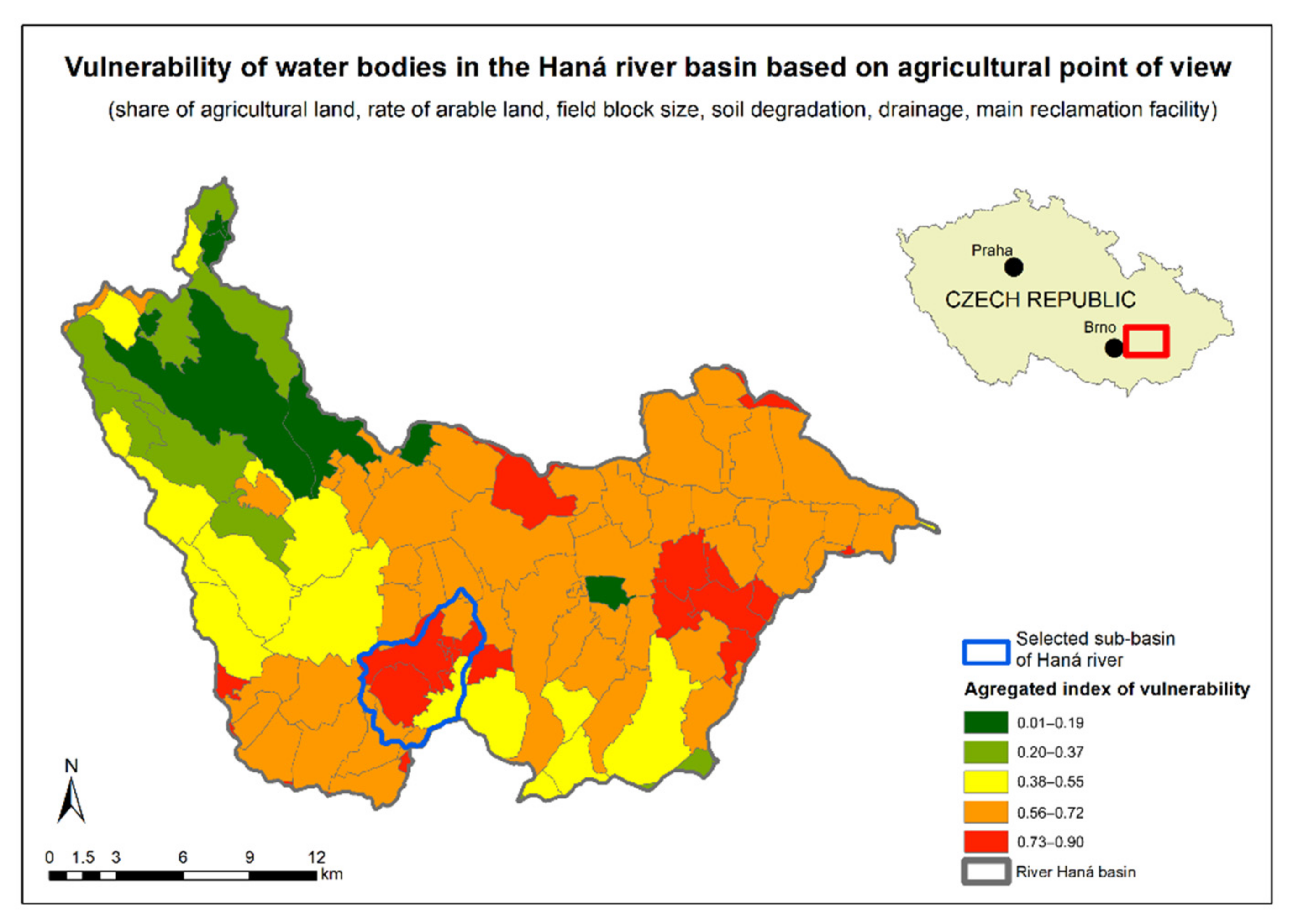
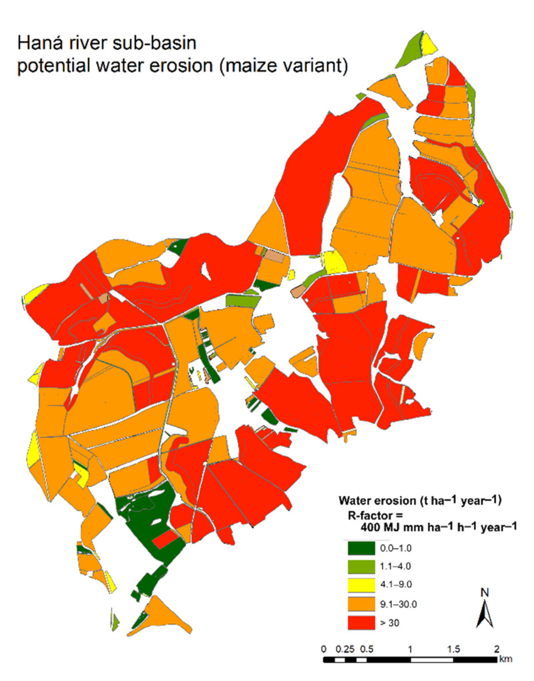
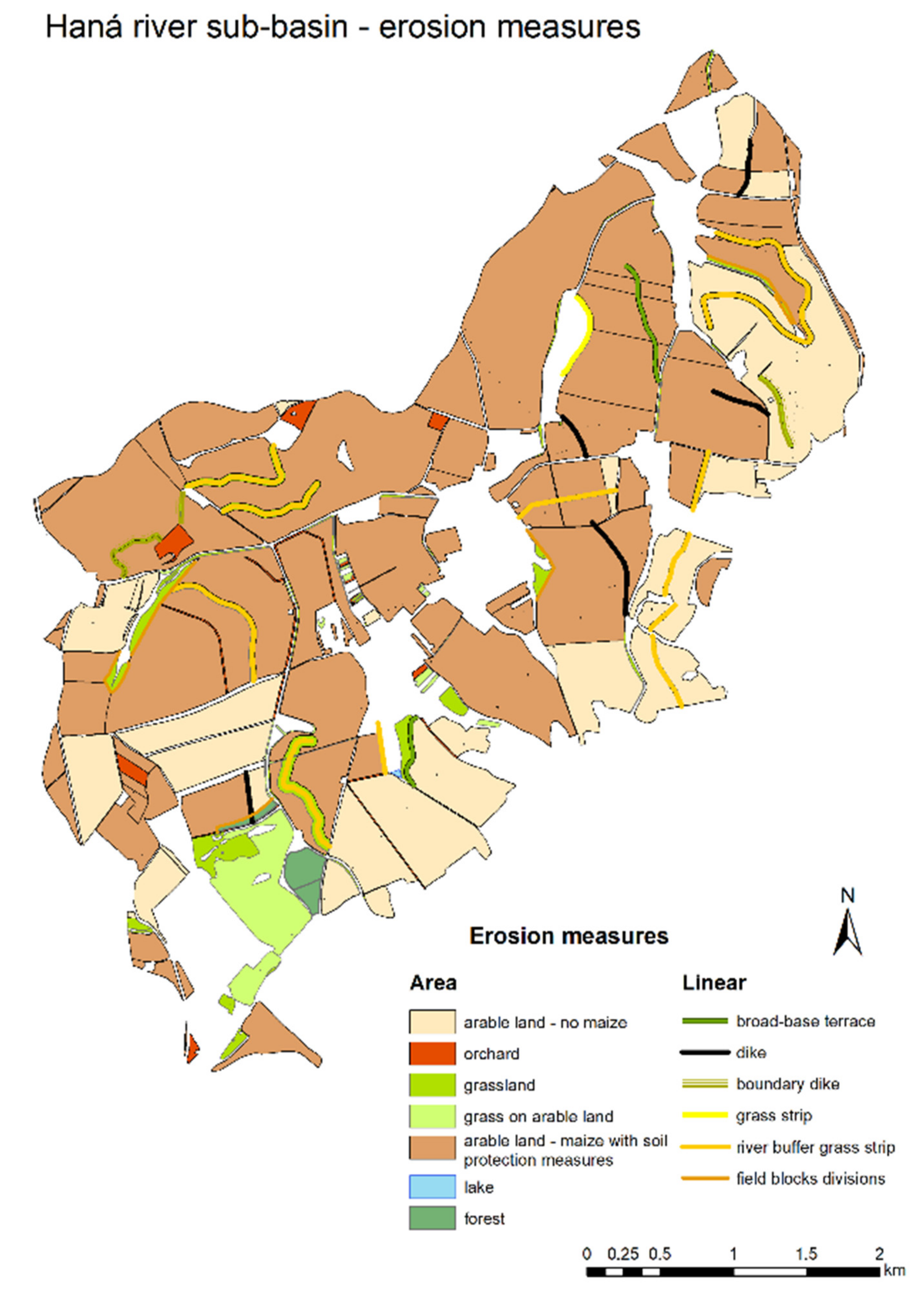
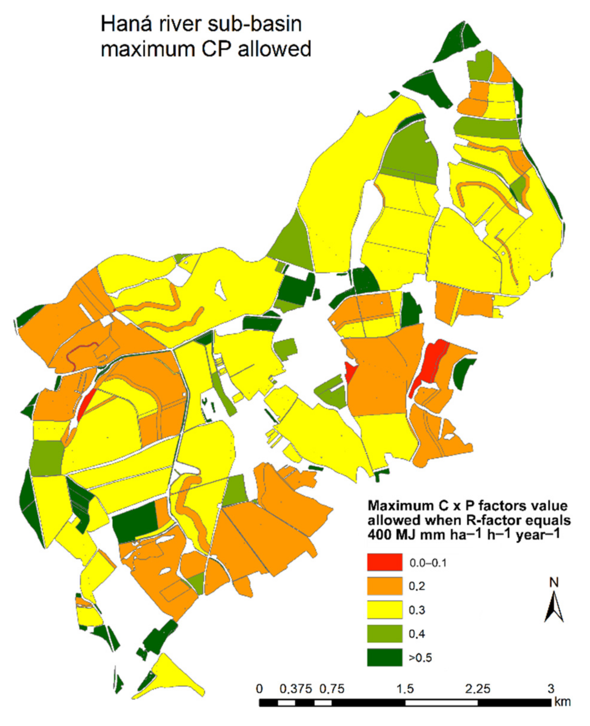
2.1. Study Area

The Haná river basin (coordinates 49.3271747° N, 17.3643167° E—confluence with the Morava river, CZ), which lies within 15 cadastral areas, was chosen as the area of interest. From a pedological point of view, a substantial part of agricultural land consists of Chernozem (typical and carbonate) and Chernozem (eroded). It is an intensively farmed area with large blocks of arable land, where, as in the whole production region, cereals (especially winter wheat) are grown on nearly half of arable land, maize takes up about 25%, winter rape about 14%, and limited areas are dedicated to the cultivation of alfalfa for livestock production. The Haná river basin occupies 490 km2, of which 59.6% comprises agricultural land. In addition to the aforementioned problems with water erosion, this area is also among several areas where water scarcity in the landscape is a significant problem.

2.2. Methodology

To select, in this respect, the most problematic sub-basin within the Haná river basin, a multicriteria analysis was performed in terms of water retention in the landscape, according to the original methodology proposed by Salvati et al. [17], adapted from Bednář and Šarapatka [18].
Multicriteria methods are used to assess a wider area from various perspectives in order to select the most suitable (most critical) area in terms of the assessor’s intention. Their goal is to summarize the effect of individual criteria, often by setting the weights of individual variables and creating evaluation metrics. In our case, the basic assessed unit was the sub-basin, and the evaluation criteria were arable land area, average land block size, CN curves, potential water erosion, surface drainage, and total degradation factor. PCA analysis was chosen as the method for evaluation, which resulted in an aggregation index. This showed how problematic the given sub-basin was in terms of water retention. The results of this research were published in the aforementioned article [18]. One of the input variables for this analysis was the results of a degradation model of the Czech Republic, which spatially evaluates individual physical, chemical, and biological types of soil degradation based on long-term measurement within a network of research stations in the Czech Republic. The result is both the degree of overall degradation threat and the spatial localization of the predominant types of soil degradation [11].
Within the selected sub-basin, the potential erosion loss was evaluated using the Universal Soil Loss Equation (USLE) model with calculation of the D-∞ Multi-Flow Direction using the Terrain Analysis Using Digital Elevation Models (TauDEM) tool.
At present, USLE and the Revised USLE (RUSLE) are by far the most widely applied soil erosion prediction models globally, and, according to Risse et al. [19], USLE has been used throughout the world for a variety of purposes and under many different conditions.
The USLE calculates annual average soil loss E (t ha−1 year−1) based on the equation:
E = R × K × C × LS × P
where: R represents rainfall erosivity factor, K soil erodibility factor, C cover management factor, LS slope length and slope steepness factors, and P support practices factor. In terms of climate change, the most important of these is the R factor, defined by Wischmeier [20] as a product of the total kinetic energy of the storm and its maximum 30 min intensity.
The contribution area was used to calculate the slope length and slope steepness (LS factor). The contribution area replaces the original parametric table values and is more accurate for inhomogeneous slopes [21]. The basis for calculation of the contribution area is the determination of outflow direction, which can be based on a single or multi-directional outflow. In our article, a more accurate model based on multi-directional outflow in the TauDEM variant was used [22].
All spatial data were processed using GIS software ArcGIS 10.4.
In the context of a changing climate, we have chosen 2 future scenarios for modeling erosion processes. In scenario 1 (current state), we use the value according to the methodology by Janeček et al. [23], where the average R factor for the Czech Republic is 400 MJ mm ha−1 h−1 year−1 (in the Czech norm, the value of 40 is given with different base units—MJ cm ha−1 h−1 year−1). In scenario 2, we use the average value R = 700 from two different sources. The first scenario was published by the team of authors [24] where, for a given river basin, it is assumed that the R factor will increase by 30% to 520 MJ mm ha−1 h−1 year−1 by 2050. The second scenario was published by Panagos et al. [25] where, for the Czech Republic, they present a scenario with an R factor value of 883.5 MJ mm ha−1 h−1 year−1 as of 2050.
The study was conducted within the period 2018–2021.

3. Results

Based on multicriteria PCA analysis of individual cadastres of the Haná river basin, a single hydrological unit was selected—the 4th order sub-basin (4-12-02-021). After evaluation of input variables (share of agricultural and arable land, size of land blocks, CN curves, water erosion, and total soil degradation) this unit proved to be the most problematic within the whole river basin in terms of erosion and water retention (Figure 1). PCA analysis was processed according to methodology by Salvati et al. [17], adjusted according to Šarapatka and Bednář [11]. The result is an aggregate vulnerability index—ranging from 0 to 1, where 1 represents the most sensitive areas.
In the selected sub-basin, with an agricultural land area of 1486 ha, existing erosion was evaluated in different scenarios, depending on the crops cultivated, using USLE/RUSLE methodology. Since a significant percentage of maize is currently grown in the selected area, as in the whole region, we report erosion affecting this crop using the R factor valid in the Czech Republic which equals 400 MJ mm ha−1 h−1 year−1. It is clear from Figure 2 that, when growing this crop, most areas have erosion washout higher than 9 t ha−1 year−1.
Due to the considerable intensity of erosion processes, we proposed both area control measures (agrotechnical) and linear measures within the model area (Figure 3). While respecting the C and P factors, these will reduce erosion washout by 73% and will respect the stated soil loss limits for CZ. On 14.8% of the land area, it is possible to apply the standard crop rotation pattern in this variant, on 53.6% of land, it is necessary to apply soil protection technology if possible with contour tillage, or to belt rotation of crops on selected areas, and on 31.6% of land area, crop rotation, with the exclusion of maize, should be applied. These values are based on the C and P factors shown in Figure 4.
In resolving erosion control, a serious problem occurs in the scenarios of anticipated climate change when we include the R factor 700 MJ mm ha−1 h−1 year−1 as the average R factor of future scenarios given in the Materials and Methods Section (Figure 5). In this case, the average water soil erosion is significantly increased and the permissible value of the multiple of C and P factors is also reduced to achieve tolerable soil loss. (Figure 6). Standard crop rotation could then be applied to 4.9% of arable land, soil protection technologies would be required on 5.1% of land area, and maize should be excluded from the crop rotation on 90% of land area. This analysis clearly shows the necessity to discuss further reduction in the size of land blocks, with greater inclusion of green infrastructure in the landscape [26,27], such as fragments of woodland, hedgerows, windbreaks, and grasslands which would break up these areas, increase diversity in the landscape, and enable sustainable agricultural management.

4. Discussion

The “Global Assessment of Soil Degradation Survey” reported that soil erosion is currently the most common form of land degradation, accounting for 84% of all degraded land [28]. The pressure to increase crop production is a very contemporary issue in a growing population, and in this context the protection of soil productivity and quality is crucial. However, there are also concerns that land management practices which have been effective in the past may not be sufficient in the future, with the anticipated level of climate change [29]. This relates to the tolerated erosion rate, a theme addressed in many papers, e.g., [30], which state that the average annual rate of soil erosion above the tolerated limit can cause irreversible long-term changes [31]. The resolution of these problems will become more and more topical, as evidenced by research carried out. For example, Routschek et al. [32] state that climate change will lead to a significant increase in land loss by 2050 and that failure to adapt agricultural management and land use to this situation will worsen erosion rates, as documented by the authors in their results from a selected river basin in Germany. The increased impact of erosion in the future is evidenced by other studies. Favis-Mortlock and Boardman [33] found that for every 7% increase in precipitation in southern England, water erosion increases by about 26%. Studies on precipitation and soil erosion in the US [34] state that a 20% increase in precipitation can cause a 37% increase in water erosion. Zhang et al. [35] state that, despite the expected decrease in total precipitation over a longer period in their monitored area, the total average runoff and soil loss will increase, due to the increased incidence of torrential rainfall.
For the above reasons, assessing the effectiveness of current soil protection practices under changing climatic conditions, with an expected increase in the frequency of torrential rainfall, is a very current and complex task with many variables, incl. climatic and agronomic [29,36,37]. Therefore, in our study, we have focused on this problem in a significant agricultural production area, which is intensively used, especially for crop production. In terms of its geomorphological and soil conditions, including current land use, this area is highly susceptible to water erosion. In the results, we state that under current conditions we are able to plan erosion control measures that will respect the current climatic conditions and the current legally valid limit of soil loss by water erosion for the Czech Republic.
However, a serious problem arises when considering future climate scenarios, where rainfall erosivity factor (R factor) is based on the average published in works [24,25] (see Section 2). In the fertile chernozem soil areas of the Czech Republic, the future problem of erosion also arises from other research works, e.g., [38]. In addition, the discussed tightening erosion limit should make this an even bigger challenge in the future. As a basis for the proposals, we used mainly agrotechnical measures, and several published studies can be used, although there is no consensus on the extent of the impact of climate change and the impact of land use and farming methods. Luetzenburg et al. [39], for example, document that soil cultivation, precipitation, and runoff are drivers of soil erosion, and suggest that management practices (reduced tillage vs. conventional tillage) may have a greater impact on soil erosion than climate change scenarios. On the other hand, Hu et al. [40] state that the impact of climate change on soil erosion is greater than the impact of change in land use. Whether the impact of the climate is greater or lesser, tillage and crop planning will have to be intensively addressed. As Zhang [35] states, soil-protection farming practices will have to be adopted over the next 30 years, as an effective erosion control measure in comparison with conventional tillage. We can also include no-tillage in these methods of soil protection. This technology is discussed, for example, by Ogle et al. [41], also in terms of carbon sequestration in the soil. According to these authors, this technology can be considered mainly as a way of reducing erosion, adapting to climate change, and ensuring food security, while any increase in SOC storage is a co-benefit for society. Significantly lower soil loss in reduced and strip tillage, compared with intensive tillage, is also discussed by Laufer et al. [42]. This reduction is due to reduced runoff rates, higher aggregate stability, and reduced velocity of runoff flow. The results of research by Tebrügge and Düring [43] show that reduced tillage and no-tillage were beneficial to the investigated soil properties compared with conventional tillage. In terms of agrotechnical measures, mulching also has a significant effect on reducing soil loss and runoff volume [44].
Of the relatively simple measures, some authors [45,46,47,48] describe contour tillage, which reduces soil erosion and increases infiltration. This method of cultivation is accepted as an effective erosion control measure. In addressing this issue in the area, we have presented, this can be problematic on many plots due to the considerable fragmentation of the land, where these measures may not be adequate in the future, much like other soil tillage techniques. In some places, strip cropping, in the spirit of rules published by the USDA [49] may be a solution. It is important to assess the effectiveness of individual measures, as discussed by Maetens et al. [50], who, based on their research, state that crop and vegetation management techniques (i.e., buffer strips, mulching, and cover crops) and mechanical techniques (i.e., contour bunds and terraces) are generally more effective than soil management techniques (i.e., no-tillage, reduced tillage, and contour tillage).
The landscape structure of agricultural field plots, which influences erosion processes in the landscape, is also very important in tackling erosion [51]. In addressing the issue, it is important to take into account the history of the area, as described by Chevigny et al. [52] in an example focusing on vineyards and an understanding of the spatial distribution of erosion. This is very important in Czech conditions, where significant changes in land use occurred, both in the postwar collectivization of agricultural land with a significant increase in the size of arable land blocks, and after 1990, when large areas were converted to permanent grassland, especially at higher elevation. This greatly affected soil erosion and sediment transport to rivers and reservoirs [53,54]. Since the Second World War, the area of landscape green infrastructure in the Czech landscape has decreased to 25–33%. After evaluation, green infrastructure in our area of interest makes up 0.73%. The EU targets for 2030 include a commitment to achieve 10% of agricultural land with a variety of landscape features, such as buffer zones, fallow land, hedges, tree vegetation, terrace walls, etc. The current EU-27 benchmark is 4.6% [55]. The Czech Republic is much worse off, with only 0.8% [55], similar to our study area, and therefore the implementation of erosion control measures, together with landscape elements and landscape connectivity, will be highly important [56].

5. Conclusions

Loss of soil, worsening soil quality, and damage to components of the environment generate a serious problem for the future in relation to agricultural management and climate change, which must be addressed in all countries. Increased attention must be paid to this problem in countries where collectivization of farming has occurred, as in the Czech Republic, with an increase in arable land blocks and the loss of landscape green infrastructure. The future scenarios presented in this article show that the current management system will not be sustainable in the long run, especially with the projected consequences of climate change.
In future scenarios respecting the soil loss tolerance limit, serious problems will arise under the current management of land blocks on up to 90% of land on which maize cultivation should be restricted, or on which crop rotation erosion control measures should be proposed. Similar problems will arise in other agricultural production areas and, concerning the new CAP rules and the discussed Green Deal, it will be necessary to address agrotechnical measures in landscape planning and plan land division with the addition of green infrastructure to a proportion higher than the current 0.8%.
This is an important and urgent task for soil protection experts, authorities responsible for food and agriculture policy, academia, and practitioners facing the task of designing a comprehensive solution employing not only agrotechnical erosion control measures, but also incorporating the landscape planning process to minimize erosion processes, as well as increasing the diversity of the rural landscape by adding a spectrum of landscape green infrastructure elements.

Author Contributions

Conceptualization, B.Š. and M.B.; methodology, B.Š. and M.B.; software, M.B.; validation, B.Š. and M.B.; formal analysis, B.Š. and M.B.; investigation, B.Š. and M.B.; resources, B.Š. and M.B.; data curation, B.Š. and M.B.; writing—original draft preparation, B.Š. and M.B.; writing—review and editing, B.Š. and M.B.; visualization, M.B.; supervision, B.Š.; project administration, B.Š.; funding acquisition, B.Š. All authors have read and agreed to the published version of the manuscript.

Funding

This research was carried out with the help of grants from the Technology Agency of the Czech Republic (project No. SS02030018) and the National Agency for Agricultural Research of the Czech Republic (project No. QK1810233).

Institutional Review Board Statement

Not applicable.

Informed Consent Statement

Not applicable.

Data Availability Statement

Not applicable.

Acknowledgments

The authors thank both the National Agency for Agricultural Research of the Czech Republic and the Technology Agency of the Czech Republic for supporting the research. They also thank Ina and Jim Leckie for linguistic proofreading of the text and our colleagues for consultation.

Conflicts of Interest

The authors declare no conflict of interest.

References

  1. Amundson, R.; Berhe, A.A.; Hopmans, J.W.; Olson, C.; Sztein, A.E.; Sparks, D.L. Soil and human security in the 21th century. Science 2015, 348, 1261071. [Google Scholar] [CrossRef] [PubMed] [Green Version]
  2. Food and Agriculture Organization (FAO). Status of the World's Soil Resources (SWSR)—Main Report; Natural Resources and Environment Department, Food and Agriculture Organization (FAO) of the United Nations and Intergovernmental Technical Panel on Soils (ITPS): Rome, Italy, 2015; Available online: http://www.fao.org/3/a-i5199e.pdf (accessed on 15 February 2021).
  3. Scherr, S.J. A downward spiral? Research evidence on the relationship between poverty and natural resource degradation. Food Policy 2000, 25, 479–498. [Google Scholar] [CrossRef]
  4. Graves, A.R.; Morris, J.; Deeks, L.K.; Rickson, R.J.; Kibblewhite, M.G.; Harris, J.A.; Truckle, I. The total costs of soil degradation in England and Wales. Ecol. Econ. 2015, 119, 399–413. [Google Scholar] [CrossRef]
  5. The Intergovernmental Panel of Climate Change (IPCC). Climate Change and Land: An IPCC Special Report on Climate Change, Desertification, Land Degradation, Sustainable Land Management, Food Security, and Greenhouse Gas Fluxes in Terrestrial Ecosystems; Shukla, P.R., Skea, J., Calvo Buendia, E., Masson-Delmotte, V., Portner, H.O., Roberts, D.C., Zhai, P., Slade, R., Connors, S., van Diemen, R., et al., Eds.; WMO and UNEP: Geneva, Switzerland, 2019. [Google Scholar]
  6. Brooks, H.E. Severe thunderstorms and climate change. Atmos. Res. 2013, 123, 129–138. [Google Scholar] [CrossRef]
  7. Basche, A.; DeLonge, M. The impact of continuous living cover on soil hydrologic properties: A meta-analysis. Soil Sci. Soc. Am. J. 2017, 81, 1179–1190. [Google Scholar] [CrossRef] [Green Version]
  8. Borrelli, P.; Robinson, D.A.; Fleischer, L.R.; Lugato, E.; Ballabio, C.; Alewell, C.; Meusburger, K.; Modugno, S.; Schütt, B.; Ferro, V. An assessment of the global impact of 21st century land use change on soil erosion. Nat. Commun. 2017, 8, 2013. [Google Scholar] [CrossRef] [Green Version]
  9. European Commission. The European Green Deal—The European Green Deal. Communication from the Commission to the European Parliament, the European Council, the Council, the European Economic and Social Committee and the Committee of the Regions, 2019. COM (2019) 640 Final. Available online: https://eur-lex.europa.eu/legal-content/EN/TXT/?qid=1588580774040&uri=CELEX%3A52019DC0640. (accessed on 15 February 2021).
  10. European Environment Agency (EEA). The European Environment—State and Outlook; Publications Office of the European Union: Luxembourg, 2020. [Google Scholar] [CrossRef]
  11. Šarapatka, B.; Bednář, M. Assessment of potential soil degradation on agricultural land in the Czech Republic. J. Environ. Qual. 2015, 44, 154–161. [Google Scholar] [CrossRef]
  12. Panagos, P.; Imeson, A.; Meusburger, K.; Borelli, P.; Poesen, J.; Alewell, C. Soil Conservation in Europe: Wish or Reality? Land Degrad. Dev. 2016, 27, 1547–1551. [Google Scholar] [CrossRef] [Green Version]
  13. Bosco, C.; de Rigo, D.; Dewitte, O.; Poesen, J.; Panagos, P. Modelling soil erosion at the European scale: Towards harmonization and reproducibility. Nat. Hazards Earth Syst. Sci. 2015, 15, 225–245. [Google Scholar] [CrossRef] [Green Version]
  14. Jones, A.; Panagos, P.; Barcelo, S.; Bouraoui, F.; Bosco, C.; Dewitte, O.; Gardi, C.; Erhard, M.; Hervás, J.; Hiederer, R.; et al. The State of Soil in Europe; Joint Research Centre Reference Report; Publications Office of the European Union: Luxembourg, 2012. [Google Scholar] [CrossRef]
  15. Panagos, P.; Borelli, P.; Poesen, J.; Ballabio, C.; Lugato, E.; Meusburger, K.; Montanarella, L.; Alewell, C. The new assessment of soil loss by water erosion in Europe. Environ. Sci. Policy 2015, 54, 438–447. [Google Scholar] [CrossRef]
  16. Panagos, P.; Ballabio, C.; Poesen, J.; Lugato, E.; Scarpa, S.; Montanarella, L.; Borrelli, P. A Soil Erosion Indicator for Supporting Agricultural, Environmental and Climate Policies in the European Union. Remote Sens. 2020, 12, 1365. [Google Scholar] [CrossRef]
  17. Salvati, L.; Bajocco, S.; Ceccarelli, T.; Zitti, M.; Perini, L. Towards a process-based evaluation of land vulnerability to soil degradation in Italy. Ecol. Indic. 2011, 11, 1216–1227. [Google Scholar] [CrossRef]
  18. Bednář, M.; Šarapatka, B. The use of multi-criteria analysis for identifying areas sensitive to land degradation and water retention. Ekológia 2018, 37, 90–100. [Google Scholar] [CrossRef] [Green Version]
  19. Risse, L.M.; Nearing, M.A.; Laflen, J.M.; Nicks, A.D. Error assessment in the universal soil loss equation. Soil Sci. Soc. Am. J. 1993, 57, 825. [Google Scholar] [CrossRef]
  20. Wischmeier, W.H. A rainfall erosion index for a universal soil-loss equation. Soil Sci. Soc. Am. Proc. 1959, 23, 246–249. [Google Scholar] [CrossRef]
  21. Benmouffok, D.; Horler, D.N.H.; Leconte, R. Automatic determination of the topographic factor required in the universal soil loss equation. In Proceedings of the 12th Canadian Symposium on Remote Sensing Geoscience and Remote Sensing Symposium, Vancouver, BC, Canada, 10–14 July 1989; Volume 4, pp. 1986–1989. [Google Scholar] [CrossRef]
  22. Tarboton, D.G. Terrain Analysis Using Digital Elevation Models (TauDEM); Utah Water Research Laboratory, Utah State University: Logan, UT, USA, 2016; Available online: http://hydrology.usu.edu/taudem/ (accessed on 15 February 2021).
  23. Janeček, M.; Dostál, T.; Kozlovsky-Dufková, J.; Dumbrovský, M.; Hůla, J. Soil Erosion Control. Methodology; VÚMOP v.v.i: Praha, Czech Republic, 2012. (In Czech) [Google Scholar]
  24. Collective. Study of Climatic Characteristics for Assessment of Elements of the Plan of Common Facilities and Assessment of Project Documentation for the Implementation of Water Management Structures; Czech University of Life Sciences, CzechGlobe, VÚV, Šindlar: Prague, Czech Republic, 2019. (In Czech) [Google Scholar]
  25. Panagos, P.; Ballabio, C.; Meusburger, K.; Spinoni, J.; Alewell, C.; Borrelli, P. Towards estimates of future rainfall erosivity in Europe based on REDES and WorldClim datasets. J. Hydrol. 2017, 548, 251–262. [Google Scholar] [CrossRef] [PubMed]
  26. European Commission. Green Infrastructure (GI)—Enhancing Europe’s Natural Capital; COM/2013/0249, Final; Communication from the Commission to the European Parliament, the Council, the European Economic and Social Committee and the Committee of the Regions; European Commission: Brussels, Belgium, 2013; Available online: https://eur-lex.europa.eu/legal-content/EN/TXT/?uri=celex%3A52013DC0249 (accessed on 15 February 2021).
  27. European Commission. Technical Information on Green Infrastructure (GI); SWD/2013/0155 Final; Commission Staff Working Document; European Commission: Brussels, Belgium, 2013; Available online: https://eur-lex.europa.eu/legal-content/EN/TXT/?uri=celex:52013SC0155 (accessed on 15 February 2021).
  28. Lal, R. Soil erosion by wind and water: Problems and prospects. In Soil Erosion Research Methods; Routledge: Boca Raton, FL, USA, 2017; pp. 1–10. [Google Scholar] [CrossRef]
  29. Garbrecht, J.D.; Nearing, M.A.; Steiner, J.L.; Zhang, X.J.; Nichols, M.H. Can conservation trump impacts of climate change on soil erosion? An assessment from winter wheat cropland in the Southern Great Plains of the United States. Weather Clim. Extrem. 2015, 10, 32–39. [Google Scholar] [CrossRef] [Green Version]
  30. Verheijen, F.G.A.; Jones, R.J.A.; Rickson, R.J.; Smith, C.J. Tolerable versus actual soil erosion rates in Europe. Earth-Sci. Rev. 2009, 94, 23–38. [Google Scholar] [CrossRef] [Green Version]
  31. Jones, R.J.; Le Bissonnais, Y.; Bazzoffi, P.; Sanchez Diaz, J.; Düwel, O.; Loj, G.; Øygarden, L.; Prasuhn, V.; Rydell, B.; Strauss, P. Nature and Extent of Soil Erosion in Europe. In Reports of the Technical Working Groups Established Under the Thematic Strategy for Soil Protection; Office for Official Publications of the European Communities: Luxembourg, 2004. [Google Scholar]
  32. Routschek, A.; Schmidt, J.; Kreienkamp, F. Impact of climate change on soil erosion—A high-resolution projection on catchment scale until 2100 in Saxony/Germany. Catena 2014, 121, 99–109. [Google Scholar] [CrossRef]
  33. Favis-Mortlock, D.; Boardman, J. Nonlinear responses of soil erosion to climate change: A modelling study on the UK South Downs. Catena 1995, 25, 365–387. [Google Scholar] [CrossRef]
  34. Nearing, M.A. Potential changes in rainfall erosivity in the US with climate change during the 21(st) century. J. Soil Water Conserv. 2001, 56, 229–232. [Google Scholar]
  35. Zhang, X.C. Cropping and Tillage Systems Effects on Soil Erosion under Climate Change in Oklahoma. Soil Sci. Soc. Am. J. 2012, 76, 1789–1797. [Google Scholar] [CrossRef]
  36. Nearing, M.A.; Pruski, F.F.; O’Neal, M.R. Expected climate change impacts on soil erosion rates: A review. J. Soil Water Conserv. 2004, 59, 43–50. [Google Scholar]
  37. Nearing, M.A.; Jetten, V.; Baffaut, C.; Cerdan, O.; Couturier, A.; Hernandez, M.; Le Bissonnals, Y.; Nicols, M.H.; Nunes, J.P.; Renschler, C.S.; et al. Modeling response of soil erosion and runoff to changes in precipitation and cover. Catena 2005, 61, 131–154. [Google Scholar] [CrossRef]
  38. Panagos, P.; Ballabio, C.; Himics, M.; Scarpa, S.; Matthews, F.; Bogonos, M.; Poesen, J.; Borrelli, P. Projections of soil loss by water erosion in Europe by 2050. Environ. J. Sci. Policy 2021, 124, 380–392. [Google Scholar] [CrossRef]
  39. Luetzenburg, G.; Bittner, M.J.; Calsamiglia, A.; Renschler, C.S.; Estrany, J.; Poeppl, R. Climate and land use change effects on soil erosion in two small agricultural catchment systems Fugnitz—Austria, Can Revull—Spain. Sci. Total Environ. 2020, 704, 135389. [Google Scholar] [CrossRef]
  40. Hu, Y.; Gao, M.; Batunacun. Evaluations of water yield and soil erosion in the Shaanxi-Gansu Loess Plateau under different land use and climate change scenarios. Environ. Dev. 2020, 34, 100488. [Google Scholar] [CrossRef]
  41. Ogle, S.M.; Alsaker, C.; Baldock, J.; Bernoux, M.; Breidt, F.J.; McConkey, B.; Vazquez-Amabile, G.G. Climate and Soil characteristics Determine Where no-till Management can Store carbon in Soils and Mitigate Greenhouse Gas emissions Step. Sci. Rep. 2019, 9, 11665. [Google Scholar] [CrossRef]
  42. Laufer, D.; Loibl, B.; Märländer, B.; Koch, H.J. Soil erosion and surface runoff under strip tillage for sugar beet (Beta vulgaris L.) in Central Europe. Soil Tillage Res. 2016, 162, 1–7. [Google Scholar] [CrossRef]
  43. Tebrügge, F.; Düring, R.A. Reducing tillage intensity—a review of results from a long-term study in Germany. Soil Tillage Res. 1999, 53, 15–28. [Google Scholar] [CrossRef]
  44. Prosdocimi, M.; Tarolli, P.; Cerdà, A. Mulching practices for reducing soil water erosion: A review. Earth-Sci. Rev. 2016, 161, 191–203. [Google Scholar] [CrossRef]
  45. Morgan, R.P.C. Soil Erosion & Conservation, 3rd ed.; Wiley-Blackwell: Malden, MA, USA, 2005. [Google Scholar]
  46. Quinton, J.N.; Catt, J.A. The effects of minimal tillage and contour cultivation on surface runoff, soil loss and crop yield in the long-term Woburn Erosion Reference Experiment on sandy soil at Woburn, England. Soil Use Manag. 2004, 20, 343–349. [Google Scholar] [CrossRef]
  47. Tadesse, L.D.; Morgan, R.P.C. Contour grass strips: A laboratory simulation of their role in erosion control using live grasses. Soil Technol. 1996, 9, 83–89. [Google Scholar] [CrossRef]
  48. Ricci, G.F.; Jeong, J.; De Girolamo, A.M.; Gentile, F. Effectiveness and feasibility of different management practices to reduce soil erosion in an agricultural watershed. Land Use Pol. 2020, 90, 104306. [Google Scholar] [CrossRef]
  49. U. S. Department of Agriculture (USDA). Conservation Practice Standard Stripcropping; Code 585; NRCS, NHCP: Washington, DC, USA, 2017. [Google Scholar]
  50. Maetens, W.; Poesen, J.; Vanmaercke, M. How effective are soil conservation techniques in reducing plot runoff and soil loss in Europe and the Mediterranean? Earth-Sci. Rev. 2012, 115, 21–36. [Google Scholar] [CrossRef] [Green Version]
  51. Van Oost, K.; Govers, G.; Desmet, P. Evaluating the effects of changes in landscape structure on soil erosion by water and tillage. Landsc. Ecol. 2000, 15, 577–589. [Google Scholar] [CrossRef]
  52. Chevigny, E.; Quiquerez, A.; Petit, C.; Curmi, P. Lithology, landscape structure and management practice changes: Key factors patterning vineyard soil erosion at metre-scale spatial resolution. Catena 2014, 121, 354–364. [Google Scholar] [CrossRef]
  53. Van Rompaey, A.; Krasa, J.; Dostal, T. Modelling the impact of land cover changes in the Czech Republic on sediment delivery. Land Use Policy 2007, 24/3, 576–583. [Google Scholar] [CrossRef]
  54. Šarapatka, B.; Štěrba, O. Optimization of agriculture in relation to the multifunctional role of the landscape. Landsc. Urban Plan. 1998, 41, 145–148. [Google Scholar] [CrossRef]
  55. European Commission. Recommendations to the Member States as Regards Their Strategic Plan for the Common Agricultural Policy; COM/2020/846 Final; Communication from the Commission to the European Parliament, the Council, the European Economic and Social Committee and the Committee of the Regions; European Commission: Brussels, Belgium, 2020; Available online: https://eur-lex.europa.eu/legal-content/EN/TXT/?uri=CELEX%3A52020DC0846 (accessed on 23 February 2022).
  56. Bednář, M.; Šarapatka, B.; Mazalová, M.; Kuras, T. Connectivity modelling with automatic determination of landscape resistance values. A new approach tested on butterflies and burnet moths. Ecol. Indic. 2020, 116, 106480. [Google Scholar] [CrossRef]
Figure 1. Results of PCA analysis evaluation for individual cadastres of the Haná river basin.
Land 11 00467 g001
Figure 2. Potential water erosion within Haná river sub-basin with maize crop variant and R factor = 400 MJ mm ha1 h1 year1.
Land 11 00467 g002
Figure 3. Identified erosion-affected areas and suggested erosion control measures in Haná sub-basin.
Land 11 00467 g003
Figure 4. Maximum C × P factors product allowed when the maximum threshold of water erosion is set at 9 t ha1 year1 (R = 400 MJ mm ha−1 h−1 year−1).
Land 11 00467 g004
Figure 5. Potential water erosion within Haná river sub-basin with maize crop variant and R factor = 700 MJ mm ha−1 h−1 year−1.
Land 11 00467 g005
Figure 6. Maximum C × P factors product allowed when the maximum threshold of water erosion is set at 9 t ha1 year1 (R = 700 MJ mm ha1 h1 year1).
Land 11 00467 g006
Publisher’s Note: MDPI stays neutral with regard to jurisdictional claims in published maps and institutional affiliations.

