
From Mounds to Villages: The Social Construction of the Landscape during the Middle and Late Holocene in the India Muerta Lowlands, Uruguay

 , and
, and
Abstract
:1. Introduction
1.1. A Spatial Approach in the South Atlantic Lowlands
1.2. Study Area
2. Materials and Methods
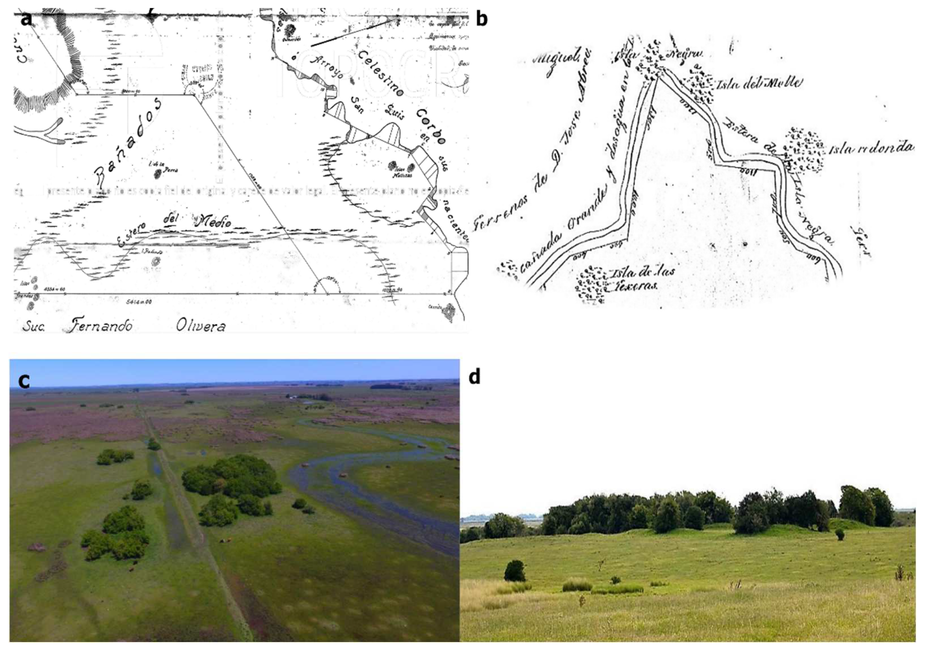
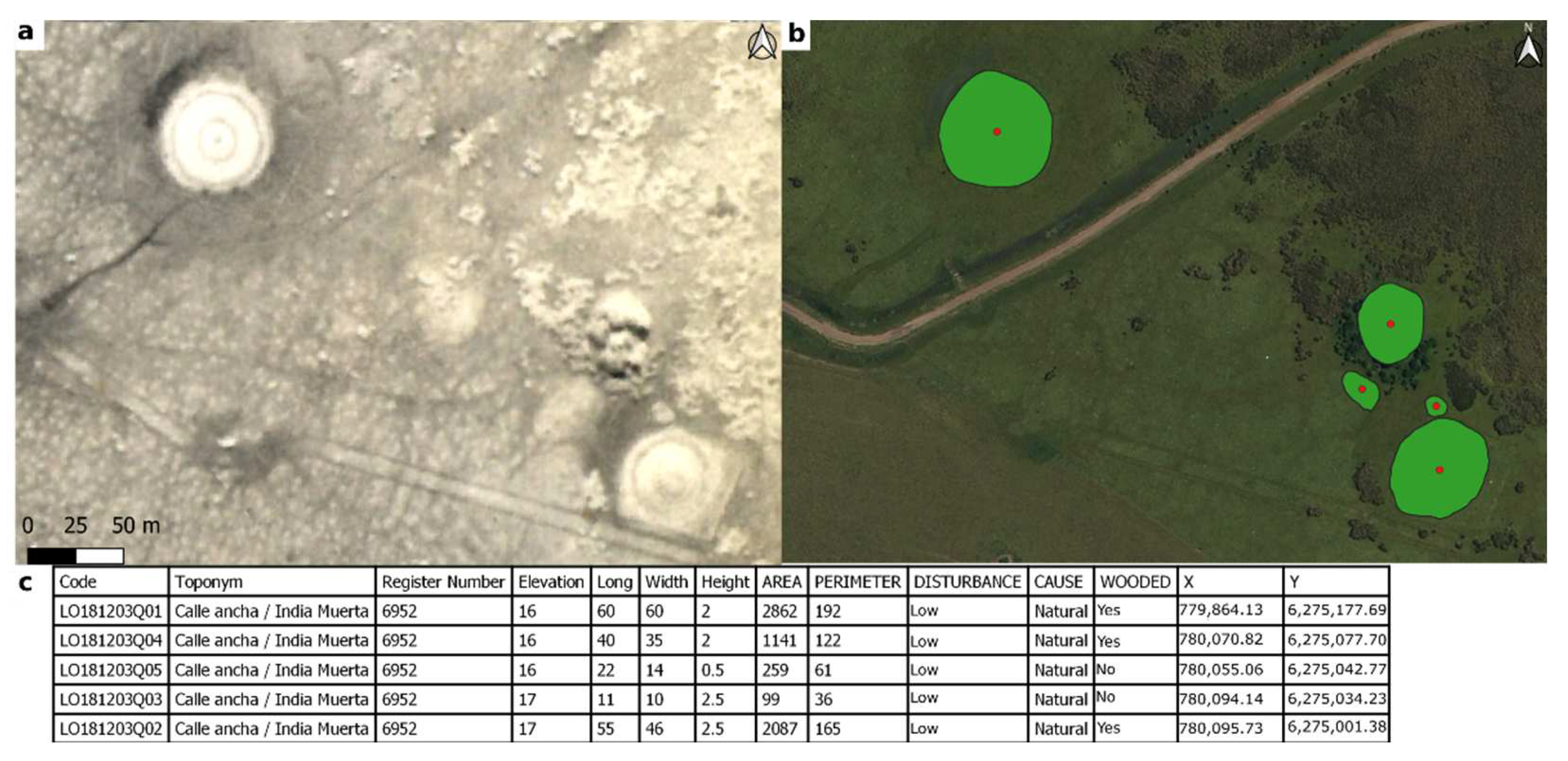
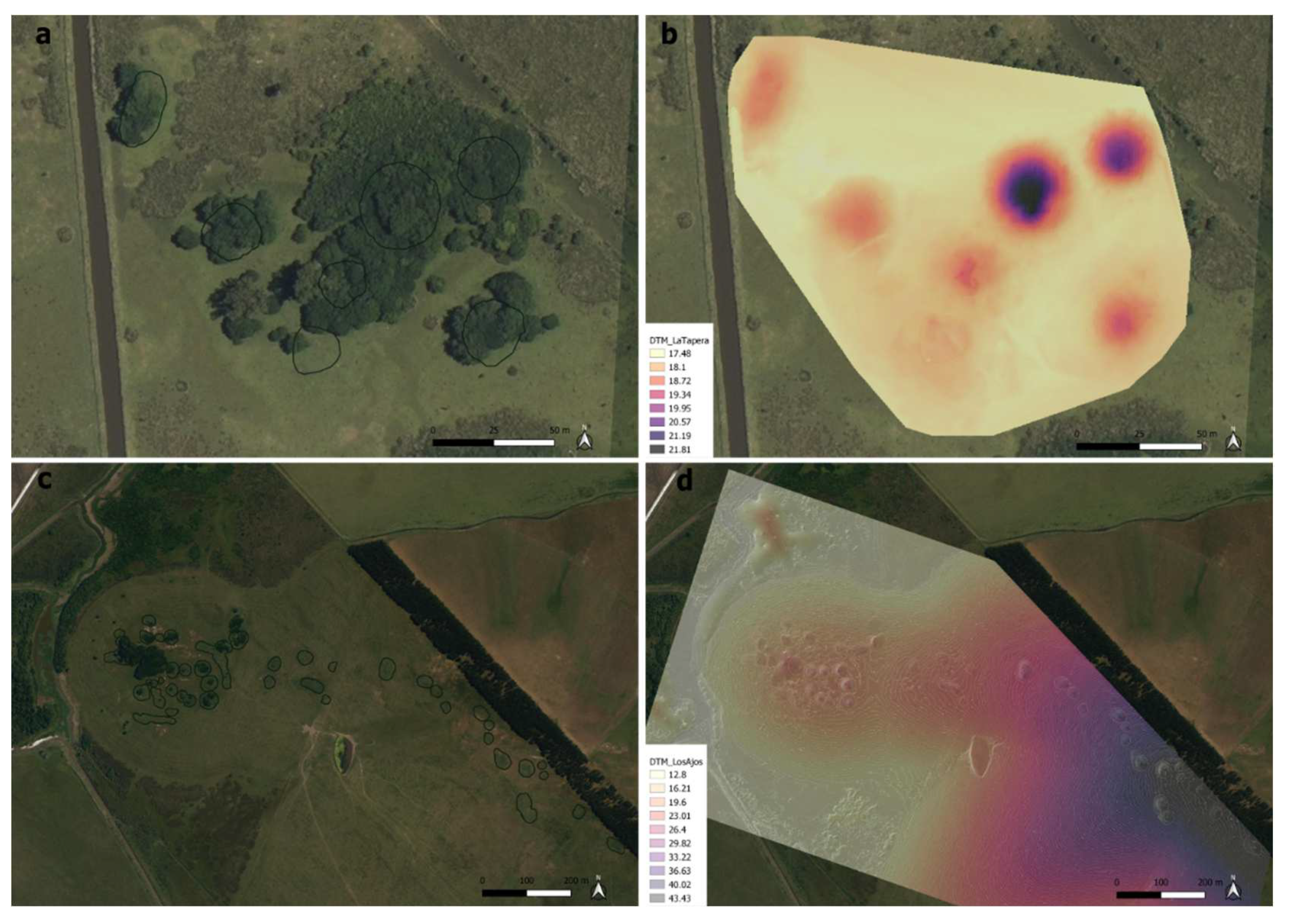
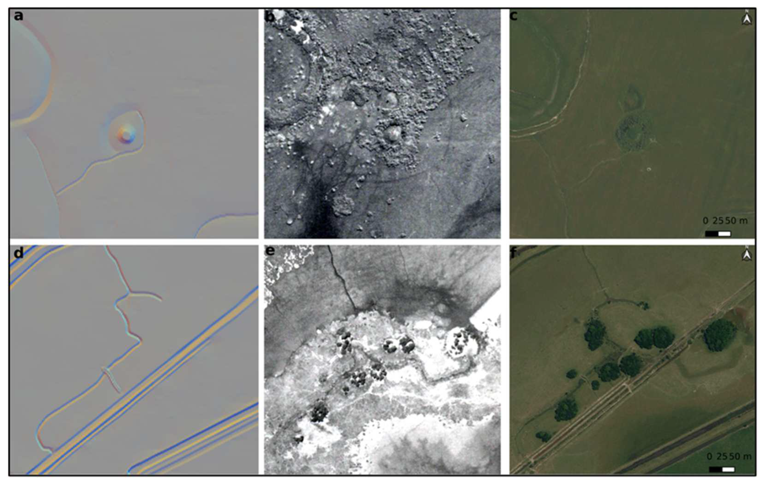
2.1. Remote Sensing
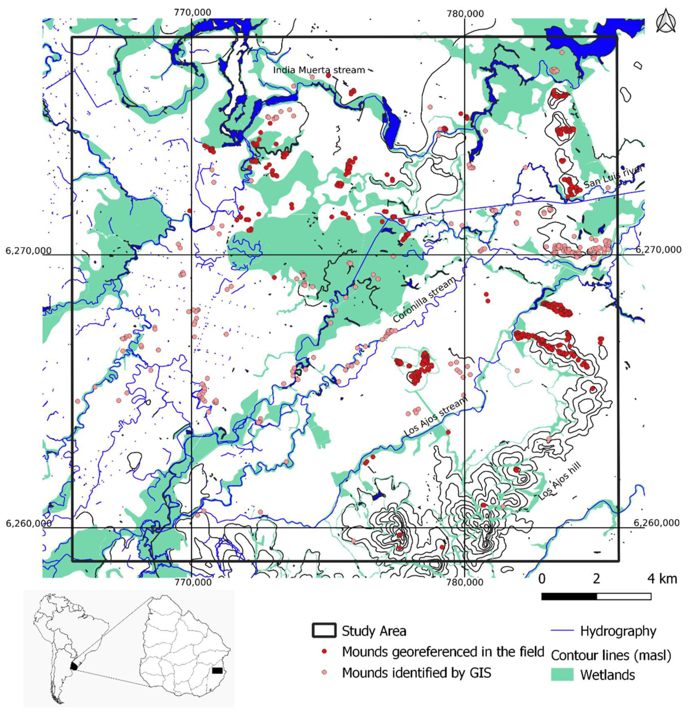
2.2. Geospatial Data and Fieldwork
2.3. Spatial Analysis
2.3.1. Distributional Analysis
2.3.2. Insularity Analysis
3. Results
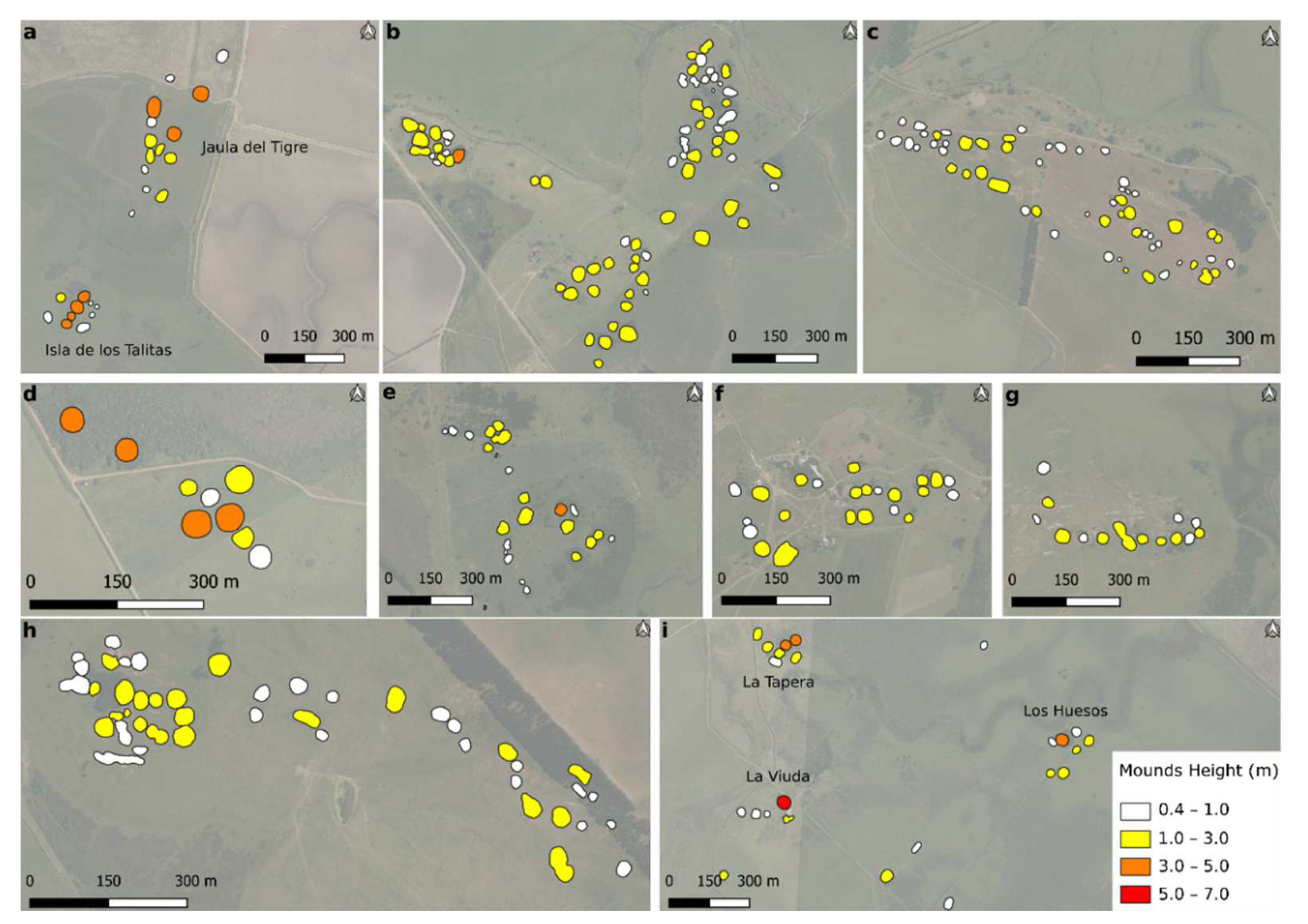
3.1. Remote Sensing
3.2. Geospatial Data and Fieldwork
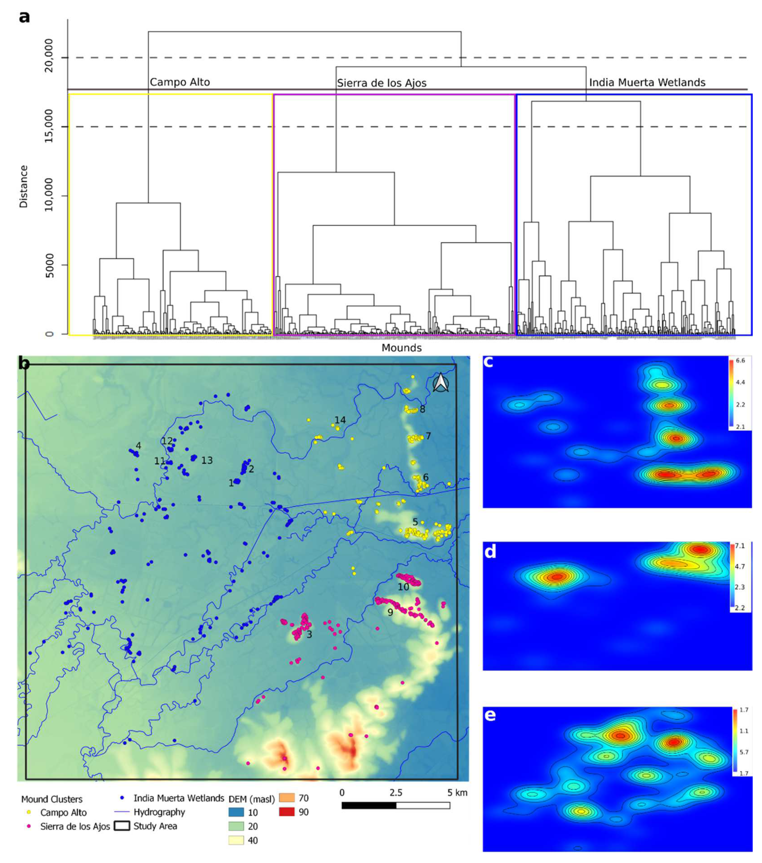
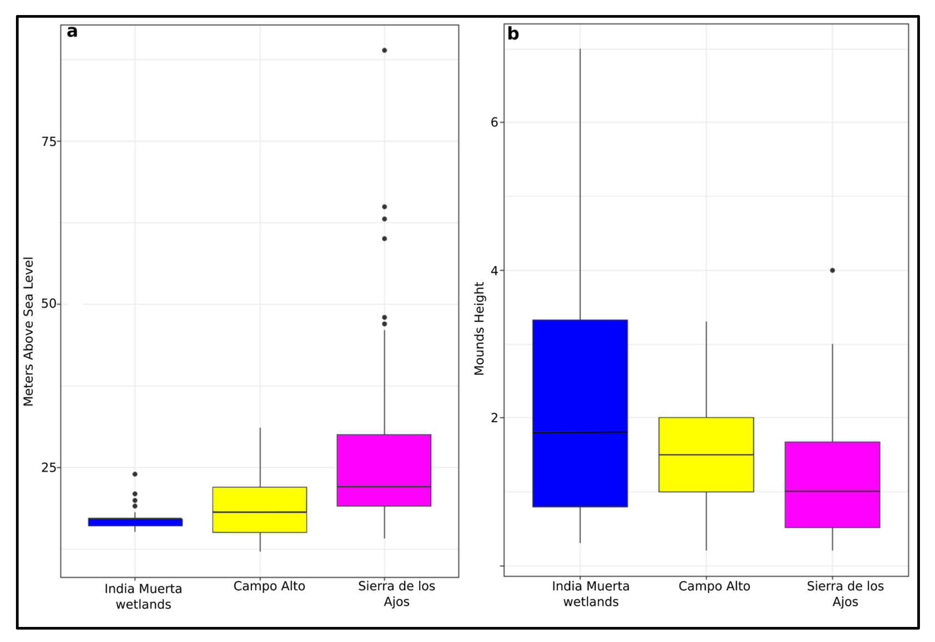
3.3. Distributional Analysis
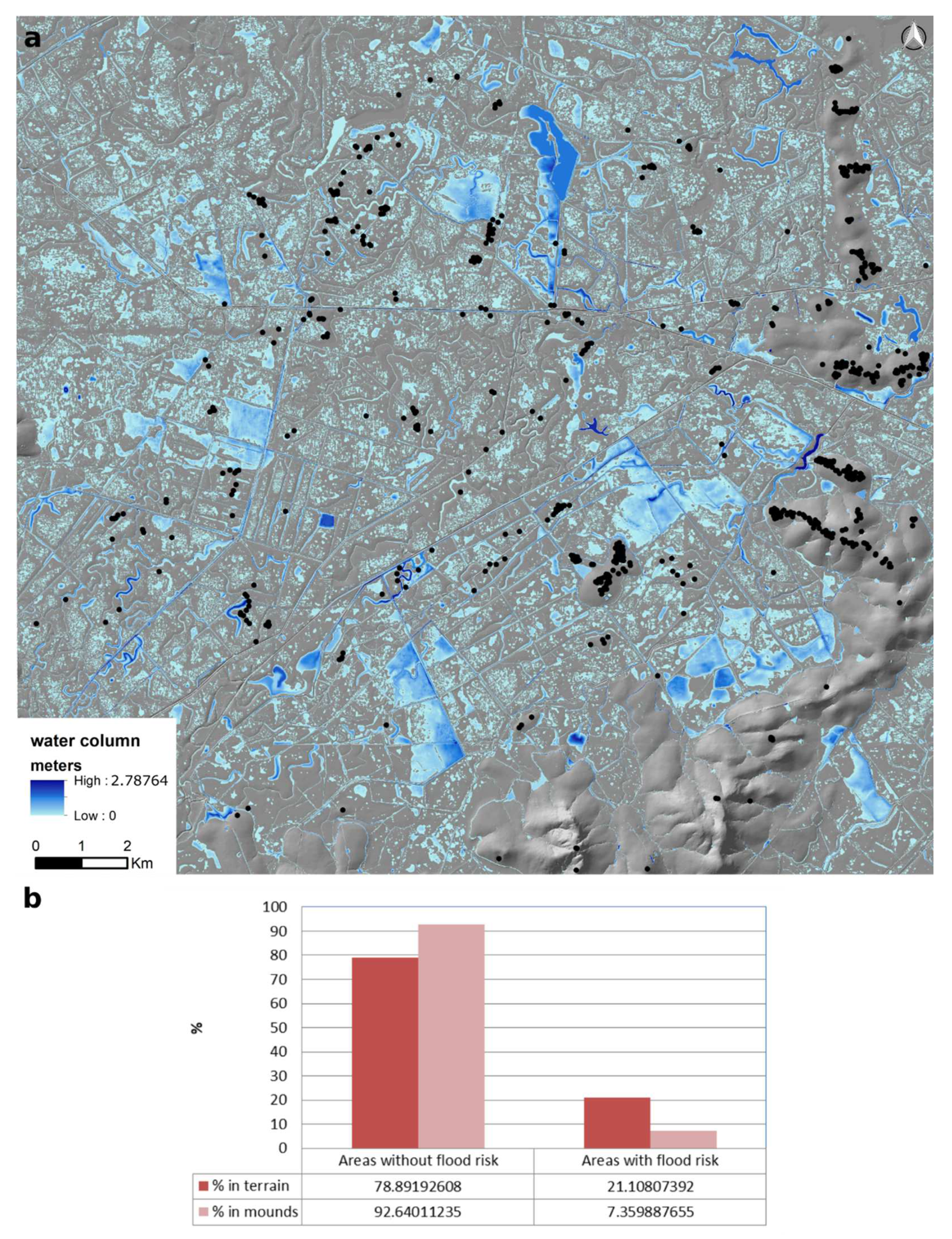
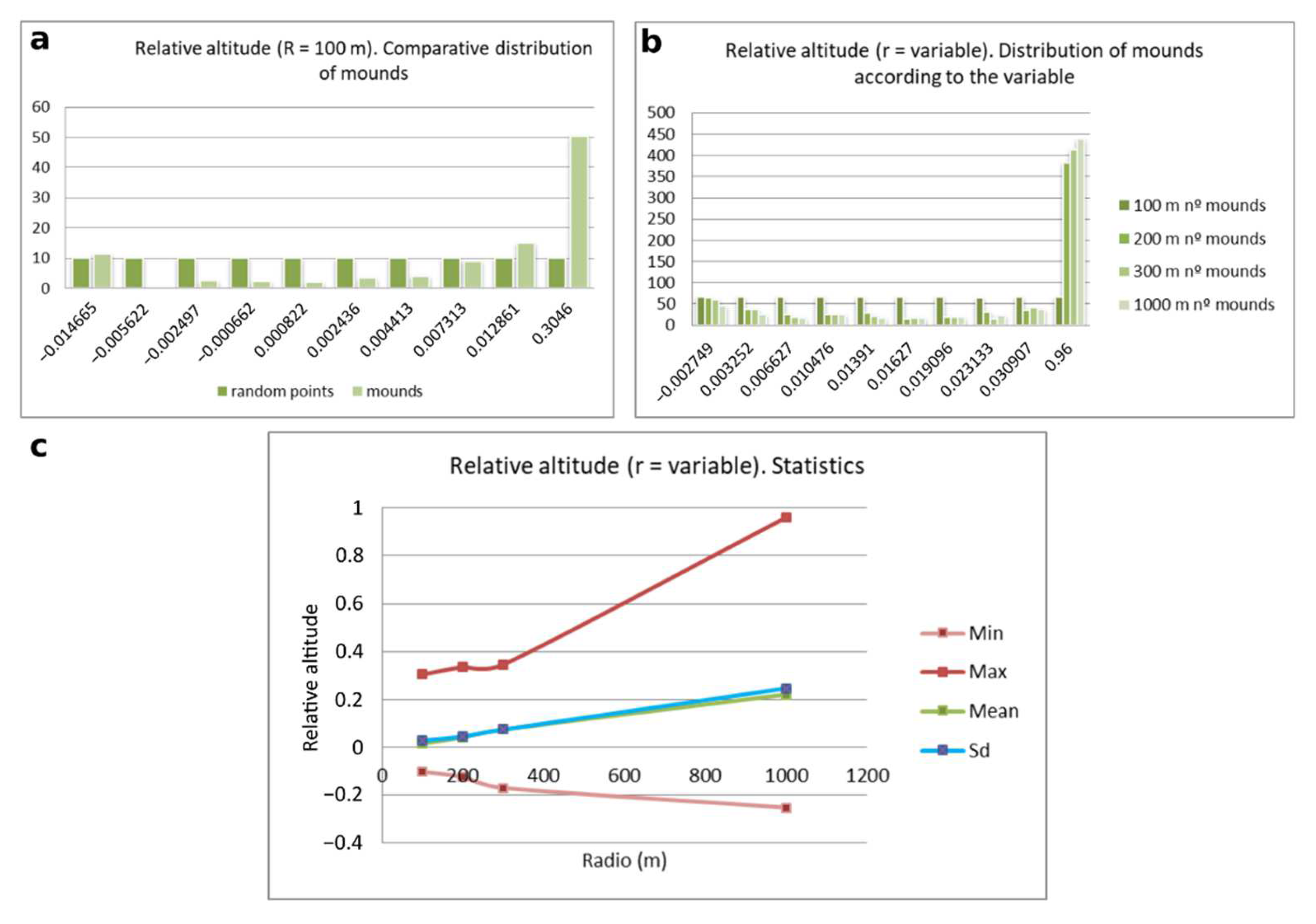
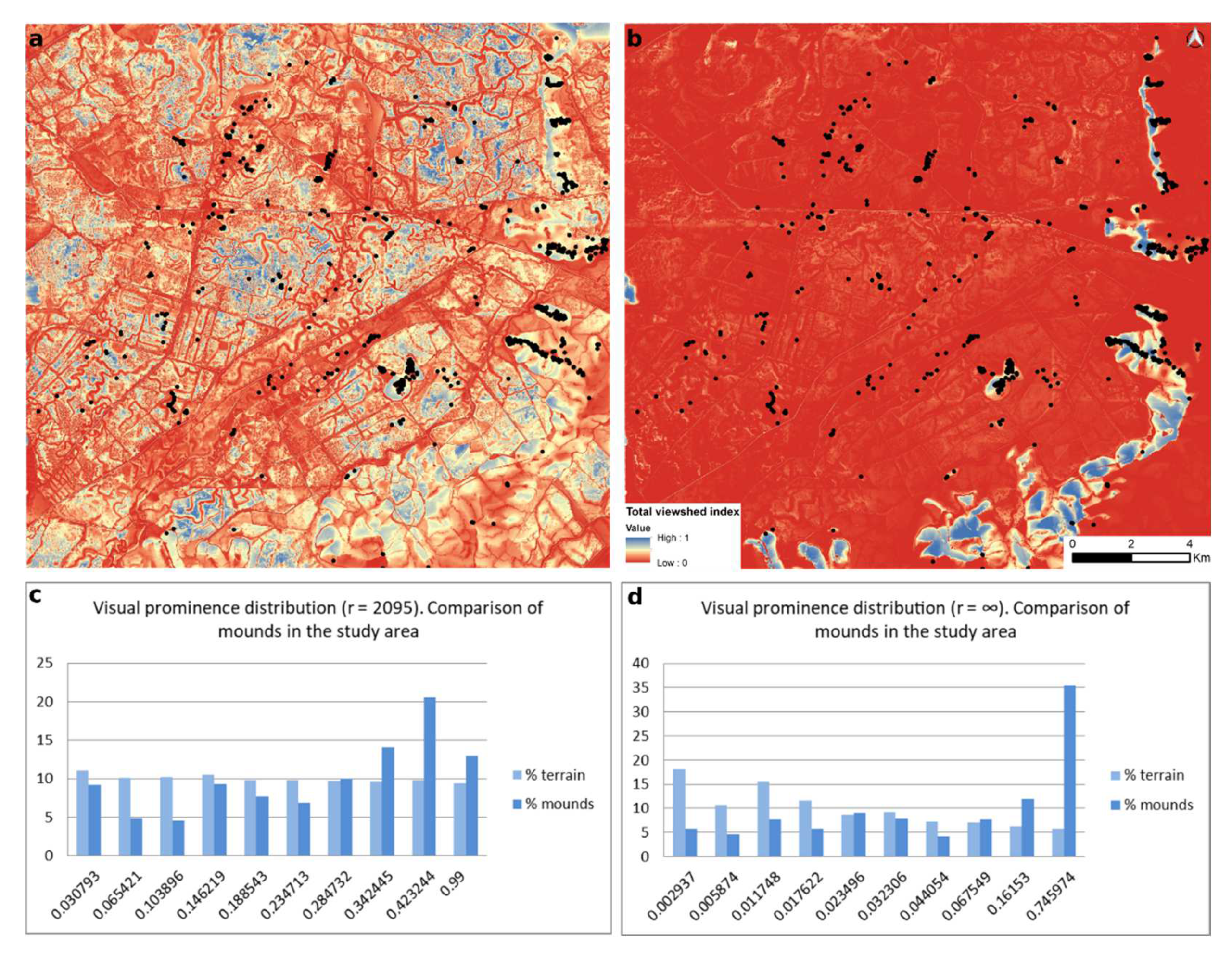
3.4. Insularity Analysis
4. Discussion and Conclusions
Author Contributions
Funding
Data Availability Statement
Acknowledgments
Conflicts of Interest
References
- Roosevelt, A.C. Moundbuilders of the Amazon: Geophysical Archaeology on Marajó Island Brazil; Academic Press: San Diego, CA, USA, 1991. [Google Scholar]
- Schaan, D. The nonagricultural chiefdoms of Marajó Island. In Handbook of South American Archaeology; Silverman, H., Isbell, W., Eds.; Springer: New York, NY, USA, 2008; pp. 339–357. [Google Scholar]
- Jaimes-Betancourt, C.; Prümers, H. A la sombra de los Andes. Arquitectura monumental en los Llanos de Mojos. In La Cooperación Científica Francesa en Latinoamérica Avances Recientes en Datación y Arqueometría en los Andes; Ghezzi, I., Salcedo, L.E., Eds.; IFEA: Lima, Peru, 2018; pp. 253–273, (Actes et Mémoires). [Google Scholar]
- Erickson, C. Amazonia: The historical ecology of a domesticated landscape. In Handbook of Southamerican Archaeology; Silvernman, H., Isbell, W.H., Eds.; Springer: New York, NY, USA, 2008; pp. 157–183. [Google Scholar]
- Barba, J.; Canal, E.; Garcia, E.; Jordá, E.; Miró, M.; Pastó, E.; Playá, R.; Romero, I.; Via, M.; Woynarovich, E. Moxos: Una Limnocultura. Cultura y Medio Natural en la Amazonia Boliviana; Centro De Estudios Amazónicos (CEAM): Barcelona, Spain, 2004. [Google Scholar]
- Denevan, W.M. Cultivated Landscapes of Native America and the Andes; Oxford University Press: New York, NY, USA, 2001. [Google Scholar]
- Erickson, C. Agency, causeways, canals, and the landscapes of everyday life in the Bolivian Amazon. In Landscapes of Movement; Trails, Paths and Roads in Anthropological Perspective; Snead, J., Erickson, C., Darling, A., Eds.; University of Pennsylvannia, Museum of Archaeology and Anthropology: Philadelphia, PA, USA, 2009. [Google Scholar]
- Rostain, S. Agricultural earth works on the French Guiana Coast. In Handbook of South American Archaeology; Silverman, H., Isbell, W., Eds.; Springer: New York, NY, USA, 2008; pp. 217–233. [Google Scholar]
- Béarez, P.; Prümers, H. Prehispanic fishing at Loma Mendoza, Llanos de Moxos, Bolivia. In The Role of Fish in Ancient Time, Proceedings of the 13th Meeting of the ICAZ Fish Remains Working Group, Basel, Switzerland, 4–9 October 2005; Plogmann, H., Ed.; Verlag Marie Leidorf GmbH: Rahden, Germany, 2007; pp. 3–10. [Google Scholar]
- Prestes-Carneiro, G.; Béarez, P.; Shock, M.P.; Prümers, H.; Betancourt, C.J. Pre-Hispanic fishing practices in interfluvial Amazonia: Zooarchaeological evidence from managed landscapes on the Llanos de Mojos savanna. PLoS ONE 2019, 14, e0214638. [Google Scholar] [CrossRef] [PubMed]
- Balee, W.; Erickson, C. Time, Complexity, and Historical Ecology; Columbia University Press: New York, NY, USA, 2006; pp. 1–20. [Google Scholar]
- Heckenberger, M.; Kuikuro, A.; Kuikuro, U.; Russell, J.; Schmidt, M.; Fausto, C.; Franchetto, B. Amazonia 1492: Pristine Forest or Cultural Parkland? Science 2003, 301, 1710–1714. [Google Scholar] [CrossRef] [PubMed] [Green Version]
- Neves, E.; Petersen, J.; Bartone, R.; Silva, C. Historical and socio-cultural origins of Amazonian dark earth. In Amazonian Dark Earths: Origins, Properties, and Management; Lehman, J., Kern, D., Glaser, B., Woods, I., Eds.; Kluwer Academic Publishers: Dordrecht, The Netherlands, 2004; pp. 29–50. [Google Scholar]
- Gassón, R. Orinoquia: The Archaeology of the Orinoco River Basin. J. World Prehist. 2002, 16, 237–311. [Google Scholar] [CrossRef]
- Jaimes-Betancourt, C.; Prümers, H. Los Llanos de Mojos. In Bolivia. Su Historia. De los Orígenes a los Estados Prehispánicos 10.000 a.C.—1540 d.C. Ximena Medinacelli (Coord.); Tomo, I., Ed.; Coordinadora de Historia: La Paz, Bolivia, 2015; pp. 209–231. [Google Scholar]
- Lombardo, U.; Prümers, H. Pre-Columbian human occupation patterns in the eastern plains of the Llanos de Moxos, Bolivian Amazonia. J. Archaeol. Sci. 2010, 37, 1875–1885. [Google Scholar] [CrossRef]
- Politis, G.; Bonomo, M. Goya-Malabrigo: Arqueología de una Sociedad Indígena del Noreste Argentino; Politis, G., Bonomo, M., Eds.; Colección Saberes, UNICEN: Tandil, Argentina, 2018. [Google Scholar]
- Schmitz, P.I.; Beber, M.V. Aterros no Pantanal do Mato Grosso do Sul, Brasil. In Arqueología de las Tierras Bajas; Durán, A., Bracco, R., Eds.; MEC, Imprenta Americana: Montevideo, Uruguay, 2000. [Google Scholar]
- Oliveira, J.E.; de Milheira, R.G. Etnoarqueologia de dois aterros Guató no Pantanal: Dinâmica construtiva e história de lugares persistentes. Mana 2021, 26, 1–39. [Google Scholar] [CrossRef]
- Milheira, R.G. Visibilidade, comunicação e movimento entre os cerriteiros na paisagem aquática da laguna dos Patos, Sul do Brasil. Bol. Do Mus. Para. Emílio Goeldi Ciências Hum. Rio Gd. Do Sul Braz. 2021, 16, e20200048. [Google Scholar] [CrossRef]
- Milheira, R.; Borges, C.; Attorre, T. Construtores de cerritos na Laguna Dos Patos, Pontal da Barra, sul do Brasil: Lugar persistente, território e ambiente construído no Holoceno recente. Lat. Am. Antiq. 2019, 30, 35–54. [Google Scholar] [CrossRef]
- Bracco, R.; Cabrera Pérez, L.; López Mazz, J.M. La prehistoria de las tierras bajas de la cuenca de la Laguna Merín. In Simposio Internacional de Arqueología de las Tierras Bajas; Duran, A., Bracco, R., Eds.; Ministerio de Educación: Montevideo, Uruguay, 2000; pp. 13–38. [Google Scholar]
- Gianotti, C. Arqueología del Paisaje en Uruguay: Origen y desarrollo de la arquitectura en tierra y su relación con la construcción del espacio doméstico en la prehistoria de las tierras bajas. In America Latina: Realidades Diversas, Barcelona: Instituto Catalán de Cooperación Iberoamericana—Casa de América; Mameli, L., Muntañola, E., Eds.; Casa Amèrica Catalunya, Universidad Autónoma de Barcelona: Barcelona, Spain, 2005; pp. 104–123. [Google Scholar]
- Iriarte, J. Vegetation and climate change since 14,810 14C yr B.P. in southeastern Uruguay and implications for the rise of early Formative societies. Quat. Res. 2006, 65, 20–32. [Google Scholar]
- López Mazz, J.M. Las estructuras tumulares del litoral atlántico uruguayo. Lat. Am. Antiq. 2001, 12, 231–255. [Google Scholar] [CrossRef]
- Criado-Boado, F. Visibilidad e interpretación del registro arqueológico. Trab. Prehist. 1993, 50, 39–56. [Google Scholar] [CrossRef]
- Clement, C.; Denevan, W.; Heckenberger, M.; Junqueira, A.; Neves, E.; Teixeira, W.; Woods, W. The Domestication of Amazonia Before European Conquest. Proc. Biol. Sci. R. Soc. 2015, 282, 20150813. [Google Scholar] [CrossRef] [PubMed] [Green Version]
- Chase, A.F.; Chase, D.Z.; Fisher, C.T.; Leisz, S.J.; Weishampel, J.F. Geospatial revolution and remote sensing LiDAR in Mesoamerican archaeology. Proc. Natl. Acad. Sci. USA 2012, 109, 12916–12921. [Google Scholar] [CrossRef] [Green Version]
- Canuto, M.; Estrada-Belli, F.; Garrison, T.; Houston, S.; Kováč, M.; Marken, D.; Nondédéo, P.; Auld–Thomas, L.; Castanet, C.; Chhatelain, D.; et al. Ancient Lowland Maya Complexity as Revealed by Airborne Laser Scanning of Northern Guatemala. Science 2018, 361, eaau0137. [Google Scholar] [CrossRef] [PubMed] [Green Version]
- Henry, E.; Shields, C.; Kidder, T. Mapping the Adena-Hopewell Landscape in the Middle Ohio Valley, USA: Multi-Scalar Approaches to LiDAR-Derived Imagery from Central Kentucky. J. Archaeol. Method Theory 2019, 26, 1513–1555. [Google Scholar] [CrossRef]
- Gregorio de Souza, J.; Schaan, D.; Robinson, M.; Damasceno, A.; Aragão, L.; Marimon, B.H.; Marimon, B.; da Silva, I.; Khan, S.; Nakahara, F.; et al. Pre-Columbian earth-builders settled along the entire southern rim of the Amazon. Nat. Commun. 2018, 9, 1125. [Google Scholar] [CrossRef] [Green Version]
- Iriarte, J.; Robinson, M.; Gregorio de Souza, J.; Barbosa, A.; Silva, F.; Nakahara, F.; Ranzi, A.; Aragão, L. Geometry by Design: Contribution of Lidar to the Understanding of Settlement Patterns of the Mound Villages in SW Amazonia. J. Comput. Appl. Archaeol. 2020, 3, 151–169. [Google Scholar] [CrossRef]
- Lombardo, U.; Canal-Beeby, E.; Veit, H. Eco-archaeological regions in the Bolivian Amazon: Linking pre-Columbian earthworks and environmental diversity. Geogr. Helv. 2011, 66, 173–182. [Google Scholar] [CrossRef] [Green Version]
- Cabrera Pérez, L. Patrimonio y arqueología en el Sur de Brasil y región Este de Uruguay: Los Cerritos de Indios. In Saldvie: Estudios de Prehistoria y Arqueología; Editorial Académica Española: Chisinau, Moldova, 2005; pp. 221–254. [Google Scholar]
- Bracco, R.; Inda, H.; del Puerto, L. Complejidad en montículos de la cuenca de la laguna Merín y análisis de redes sociales. Intersecc. Antropol. 2015, 16, 271–286. [Google Scholar]
- Del Puerto, L.; Gianotti, C.; Bortolotto, N.; Gazzán, N.; Cancela, C.; Orrego, B.; Inda, H. Geoarchaeological signatures of anthropogenic soils in southeastern Uruguay: Approaches to formation processes and spatial-temporal variability. Geoarchaeology 2021, 37, 180–197. [Google Scholar] [CrossRef]
- Cabrera Pérez, L.; Marozzi, O. Las áreas domésticas de los constructores de cerritos: El sitio CG14EO1. In Arqueología Uruguaya Hacia el Fin del Milenio, IX Congreso de Arqueología Uruguaya, Colonia del Sacramento, Uruguay, 16–19 June 1997; Asociacion Uruguaya de Arqueologia: Montevideo, Uruguay, 2001; pp. 55–68. [Google Scholar]
- Milheira, R.G.; Gianotti, C. The Earthen Mounds (Cerritos) of Southern Brazil and Uruguay. In Encyclopedia of Global Archaeology; Smith, C., Ed.; Springer Nature: Cham, Switzerland, 2018. [Google Scholar]
- Bracco, R. Montículos de la Cuenca de la Laguna Merín: Tiempo, Espacio y Sociedad. Lat. Am. Antiq. 2006, 17, 511–540. [Google Scholar]
- Bonomo, M.; Politis, G.G.; Gianotti, C. Montículos, jerarquía social y horticultura en las sociedades indígenas del delta del Río Paraná (Argentina). Lat. Am. Antiq. 2011, 22, 297–333. [Google Scholar] [CrossRef]
- Cabrera Pérez, L. Construcciones en tierra y estructura social en el Sur del Brasil y Este de Uruguay (Ca. 4.000 a 300 a. A.P.). Techne 2013, 1, 25–33. [Google Scholar]
- Gianotti, C. Paisajes Sociales, Monumentalidad y Territorio en las Tierras Bajas de Uruguay. Ph.D. Thesis, Universidade de Santiago de Compostela, Santiago de Compostela, Spain, 2015. [Google Scholar]
- López Mazz, J.M.; Rostain, S.; Mckey, D. Cerritos, tolas, tesos, camellones y otros montículos de las Tierras Bajas de Sudamérica. Rev. Arqueol. 2017, 29, 86–113. [Google Scholar] [CrossRef] [Green Version]
- Iriarte, J.; Holst, I.; Marozzi, O.; Listopad, C.; Alonso, E.; Rinderknecht, A.; Montaña, J. Evidence for cultivar adoption and emerging complexity during the mid-Holocene in the La Plata basin. Nature 2005, 432, 614–617. [Google Scholar] [CrossRef]
- López Mazz, J.; Gascue, A. Aspectos de las tecnologías líticas desarrolladas por los grupos constructores de cerritos del Arroyo Yaguarí. In Desarrollo Metodológico y Aplicación de Nuevas Tecnologías para la Gestión Integral del Patrimonio Arqueológico en Uruguay; Gianotti, C., Ed.; TAPA 36, Laboratorio de Arqueología del Paisaje (IEGPS—CSIC): Santiago de Compostela, Spain, 2005; pp. 123–136. [Google Scholar]
- Gianotti, C. Monumentalidad, ceremonialismo y continuidad ritual. In Paisajes Culturales Sudamericanos: De las Prácticas a las Representaciones. Paisajes Culturales Sudamericanos: De las Prácticas a las Representaciones TAPA 19; Gianotti, C., Ed.; Laboratorio de Arqueología y Formas Culturales: Santiago de Compostela, Spain, 2000; pp. 81–102. [Google Scholar]
- Gianotti, C.; Leoz, E. Hacia una arqueología del movimiento en la cuenca del arroyo Yaguarí, Tacuarembó, R.O.U. In Arqueología Uruguaya Hacia el fin del Milenio. IX Congreso de Arqueología Uruguaya, Colonia del Sacramento, Uruguay, 16–19 June 1997; Asociacion Uruguaya de Arqueologia: Montevideo, Uruguay, 2001. [Google Scholar]
- Pintos, S. Cazadores recolectores complejos: Monumentalidad en tierra en la cuenca de la Laguna de Castillos. In Paisajes Culturales Sudamericanos: De las Prácticas Sociales a las Representaciones; Gianotti, C., Ed.; Universidad Santiago de la Compostela: Santiago de Compostela, Spain, 2000; pp. 75–82. [Google Scholar]
- Gianotti, C.; del Puerto, L.; Capdepont, I. Construir para producir. Pequeñas elevaciones en tierra para el cultivo del maíz en el sitio Cañada de los Caponcitos, Tacuarembó (Uruguay). Cuad. Inst. Nac. Antropol. Pensam. Latinoam. 2013, 1, 12–25. [Google Scholar]
- Suárez-Villagrán, X.; Gianotti, C. Earthen mound formation in the Uruguayan lowlands (South America): Micromorphological analyses of the Pago Lindo archaeological complex Mound-builders. J. Archaelog. Sci. 2013, 40, 1093–1107. [Google Scholar] [CrossRef]
- Bracco, R.; López Mazz, J.M. Prospección Arqueológica y Análisis de Fotos Aéreas. Primeras Jornadas de Ciencias Antropológicas; Ministerio de Educación: Montevideo, Uruguay, 1992; pp. 51–56. [Google Scholar]
- Iriarte, J. Mid-Holocene Emergent Complexity and Landscape Transformation: The Social Construction of Early Formative Communities in Uruguay, La Plata Basin. Ph.D. Thesis, College of Arts and Science, University of Kentucky, Lexington, KY, USA, 2003. [Google Scholar]
- López Mazz, J.M.; Pintos, S. Distribución Espacial de Estructuras Monticulares en la Cuenca de la Laguna Negra. In Arqueología de las Tierras Bajas; Durán, A., Bracco, R., Eds.; Imprenta Americana: Montevideo, Uruguay, 2000; pp. 49–58. [Google Scholar]
- Curbelo, C.; Cabrera Pérez, L.; Fusco, N.; Martínez, E.; Bracco, R.; Femenias, J.; López Mazz, J.M. Estructuras de sitio y zonas de actividad: Sitio CH2D01, área de San Miguel, Departamento de Rocha. Rev. CEPA 1990, 17, 333–344. [Google Scholar]
- Iriarte, J. Landscape transformation, mounded villages and adopted cultigens: The rise of early Formative communities in south-eastern Uruguay. World Archaeol. 2006, 38, 644–663. [Google Scholar] [CrossRef]
- López Mazz, J.M.; Gianotti, C. Construcción de espacios ceremoniales públicos entre los pobladores de las tierras bajas de Uruguay. Rev. Arqueol. 1998, 11, 87–105. [Google Scholar] [CrossRef]
- Gazzán, N.; Chiglino, L.; Gianotti, C. Late Holocene raw material procurement and mobility patterns in northeast Uruguay (Pago Lindo site, Tacuarembó). J. Archaeol. Sci. Rep. 2019, 25, 548–560. [Google Scholar] [CrossRef]
- Del Puerto, L. Interrelaciones Humano Ambientales Durante el Holoceno Tardío en el Este de Uruguay: Cambio climático y dinámica general. Ph.D. Thesis, Universidad de la República, Montevideo, Uruguay, 2015. [Google Scholar]
- Mourelle, D. Cambios de la Vegetación de la Región de los Campos de Uruguay en Respuesta a Diferentes Forzantes Durante el Holoceno. Ph.D. Thesis, Universidad Nacional de Mar del Plata, Mar del Plata, Argentina, 2015. [Google Scholar]
- Bracco, R.; del Puerto, L.; Inda, H.; Panario, D.; Castiñeira Latorre, C.; Garcia Rodriguez, F. The relationship between emergence of mound builders in SE Uruguay and climate change inferred from opal phytolith records. Quat. Int. 2011, 245, 62–73. [Google Scholar] [CrossRef]
- Del Puerto, L. Silicofitolitos como Indicadores Paleoambientales: Bases Comparativas y Reconstrucción Paleoclimática a Partir del Pleistoceno Tardío en el SE del Uruguay. Master’s Thesis, PEDECIBA, Universidad de la República, Montevideo, Uruguay, 2009. [Google Scholar]
- Inda, H.; del Puerto, L.; Castiñeira, C.; Capdepont, I.; García Rodríguez, F. Manejo prehistórico de recursos costeros en el litoral atlántico uruguayo. In Bases para el Manejo y Conservación de la Costa Uruguaya; Menafra, R., Rodríguez-Gallego, L., Scarabino, F., Conde, D., Eds.; Vida Silvestre: Montevideo, Uruguay, 2006; pp. 661–667. [Google Scholar]
- Mourelle, D.; Prieto, A.; Perez, L.; García-Rodríguez, F.; Borel, C. Mid and late Holocene multiproxy analysis of environmental changes linked to sea-level fluctuation and climate variability of the Río de la Plata estuary. Palaeogeogr. Palaeoclimatol. Palaeoecol. 2015, 421, 75–88. [Google Scholar] [CrossRef]
- Montaña, J.; Bossi, J. Geomorfología de los Humedales de la Cuenca de la Laguna Merín en el Departamento de Rocha; Universidad de la República, Facultad de Agronomia-PROBIDES: Montevideo, Uruguay, 1995. [Google Scholar]
- Iriarte, J.; Corteletti, R.; de Souza, J.G.; DeBlasis, P. Landscape dynamics in the La Plata Basin during the mid and late Holocene. Cad. Do LEPAARQ (UFPEL) 2016, 13, 268–302. [Google Scholar]
- Del Puerto, L.; Gianotti, C.; Inda, H. Gestión del medio y producción de recursos en las tierras bajas del Noreste de Uruguay: Análisis paleoetnobotánico del sitio Pago Lindo. Cad. Do LEPAARQ (UFPEL) 2016, 13, 197–222. [Google Scholar]
- Štular, B.; Kokalj, Ž.; Oštir, K.; Nuninger, L. Visualization of lidar-derived relief models for detection of archaeological features. J. Archaeol. Sci. 2012, 39, 3354–3360. [Google Scholar] [CrossRef]
- R Core Team. R: A Language and Environment for Statistical Computing (v. 4.0.2) [Computer Software]. In R Foundation for Statistical Computing; 2020. Available online: https://www.r-project.org/index.html (accessed on 2 August 2021).
- Carlson, D.L. Quantitative Methods in Archaeology Using R; Cambridge University Press: Cambridge, UK, 2017. [Google Scholar] [CrossRef]
- Thompson, A.E.; Meredith, C.; Prufer, K. Comparing geostatistical analyses for the identification of neighborhoods, districts, and social communities in archaeological contexts: A case study from two ancient Maya centers in southern Belize. J. Archaeol. Sci. 2018, 97, 1–13. [Google Scholar] [CrossRef]
- Hammer, Ø. Reference Manual Paleontological Statistics Version 3.15; Natural History Museum University of Oslo: Oslo, Norway, 2017. [Google Scholar]
- Maximiano, A. Teoría Geoestadística Aplicada al Análisis de la Variabilidad Espacial Arqueológica Intra-Site. Ph.D. Thesis, Universidad Autónoma de Barcelona, Barcelona, Spain, 2008. [Google Scholar]
- Nigst, P.; Antl-Weiser, W. Intrasite Spatial Organization of Grub/Kranawetberg: Methodology and Interpretations. In Insights into the Spatial Organization of Gravettian Sites in Eastern Central Europe; Verlag des RGZM: Mainz, Germany, 2011; pp. 11–29. [Google Scholar]
- Oron, M.; Goren-Inbar, N. Mousterian intra-site spatial patterning at Quneitra, Golan Heights. Quat. Int. 2014, 331, 186–202. [Google Scholar] [CrossRef]
- Parcero-Oubiña, C.; Fábrega-Álvarez, P. Diseño metodológico para el análisis locacional de asentamientos a través de un SIG de base Raster. In Territorios Antiguos y Nuevas Tecnologías. La aplicación de los SIG en la Arqueología del Paisaje; Universidad de Alicante: Alicante, Spain, 2006; pp. 69–91. [Google Scholar]
- Fábrega-Álvarez, P. Poblamiento y Territorio de la Cultura Castreña en la Comarca de Ortegal; CAPA 19: Santiago de Compostela, Spain, 2004. [Google Scholar]
- Wheatley, D.W.; Gillings, M. Vision, perception and GIS: Developing enriched approaches to the study of archaeological visibility. In Beyond the Map; Lock, G., Ed.; IOS Press: Amsterdam, The Netherlands, 2000. [Google Scholar]
- Criado-Boado, F. Arqueológicas. La Razón Perdida; Ediciones Bellaterra: Barcelona, Spain, 2013. [Google Scholar]
- Loots, L. The use of projective and reflective viewsheds in the analysis of the Hellenistic defense system at Sagalassos. Archaeol. Comput. Newsl. Univ. Turk. 1997, 49, 12–16. [Google Scholar]
- Fábrega-Álvarez, P.; Parcero-Oubiña, C. Now you see me. An assessment of the visual recognition and control of individuals in archaeological landscapes. J. Archaeol. Sci. 2019, 104, 56–74. [Google Scholar]
- Fábrega-Álvarez, P. Recorriendo y Observando Paisajes Digitales. Una Aproximación al Análisis Arqueológico con Tecnologías de la Información Geográfica (TIG). Ph.D. Thesis, Repositorio Institucional de Producción Científica (RUJA), Universidad de Jaén, Jaén, Spain, 2017. [Google Scholar]
- Llobera, M. Extending GIS-based visual analysis: The concept of visualscapes. Int. J. Geogr. Inf. Sci. 2003, 17, 25–48. [Google Scholar] [CrossRef]
- Llobera, M.; Wheatley, D.; Steele, J.; Cox, S.; Parchement, O. Calculating the inherent visual structure of a landscape (‘total viewshed’) using highthroughput computing. In Beyond the Artifact: Digital Interpretation of the Past, Proceedings of the 32nd Computer Applications and Quantitative Methods in Archaeology conference (CAA 2004), Prato, Italy, 13–17 April 2004; Llobera, M., Wheatley, D., Steele, J., Cox, S., Parchement, O., Eds.; Archaeolingua: Budapest, Hungary, 2010. [Google Scholar]
- Kokalj, Ž.; Somrak, M. Why Not a Single Image? Combining Visualizations to Facilitate Fieldwork and on-Screen Mapping. Remote Sens. 2019, 11, 747. [Google Scholar]
- Zakšek, K.; Oštir, K.; Kokalj, Ž. Sky-View Factor as a Relief Visualization Technique. Remote Sens. 2011, 3, 398–415. [Google Scholar] [CrossRef] [Green Version]
- Kaal, J.; Gianotti, C.; del Puerto, L.; Criado-Boado, F.; Rivas, M. Molecular features of organic matter in anthropogenic earthen mounds, canals and lagoons in the Pago Lindo archaeological complex (Tacuarembó, Uruguayan lowlands) are controlled by pedogenetic processes and fire practices. J. Archaeol. Sci. Rep. 2019, 26, 101900. [Google Scholar] [CrossRef]
- Gianotti, C. Environment Transformation and Landscape Domestication in the Lowlands of Northeast of Uruguay. In Earthworks as Technology for the Management of Flood Ecosystems; Bonomo, M., Archila, S., Eds.; South American Contributions to World Archaeology One World Archaeology; Springer: Cham, Switzerland, 2021; pp. 283–316. [Google Scholar]
- Blatrix, R.; Roux, B.; Béarez, P.; Prestes-Carneiro, G.; Amaya, M.; Aramayo, J.; Rodrigues, L.; Lombardo, U.; Iriarte, J.; Gregorio de Souza, J.; et al. The unique functioning of a pre-Columbian Amazonian floodplain fishery. Sci. Rep. 2018, 8, 5998. [Google Scholar] [CrossRef] [PubMed]
- Gianotti, C.; Bonomo, M. De montículos a paisajes: Procesos de transformación y construcción de paisajes en el sur de la cuenca del Plata. Comechingonia 2013, 17, 129–163. [Google Scholar] [CrossRef] [Green Version]
- Del Puerto, L.; Bracco, R.; Inda, H.; Gutiérrez, O.; Panario, D.; García-Rodríguez, F. Assessing links between late Holocene climate change and paleolimnological development of Peña Lagoon using opal phytoliths, physical, and geochemical proxies. Quat. Int. 2013, 287, 89–100. [Google Scholar] [CrossRef]


| Length (m) | Width (m) | Height (m) | |
|---|---|---|---|
| Min. | 9 | 6 | 0.4 |
| 1st Quartile | 25 | 21 | 0.7 |
| Median | 34 | 27 | 1.2 |
| Mean | 36 | 30 | 1.5 |
| 3rd Quartile | 43 | 35 | 2.0 |
| Max. | 150 | 83 | 7.0 |
| Mean Distance | Expected Distance | R | Area | Density of Mounds/km2 (Convex Hull) | |
|---|---|---|---|---|---|
| Campo Alto | 86.367 | 231.54 | 0.373 | 190 | 4.6 |
| Sierra de los Ajos | 87.534 | 224.14 | 0.390 | 50 | 5 |
| India Muerta wetlands | 165.82 | 361.21 | 0.459 | 120 | 1.9 |
Publisher’s Note: MDPI stays neutral with regard to jurisdictional claims in published maps and institutional affiliations. |
© 2022 by the authors. Licensee MDPI, Basel, Switzerland. This article is an open access article distributed under the terms and conditions of the Creative Commons Attribution (CC BY) license (https://creativecommons.org/licenses/by/4.0/).
Share and Cite
Gazzán, N.; Cancela-Cereijo, C.; Gianotti, C.; Fábrega-Álvarez, P.; del Puerto, L.; Criado-Boado, F. From Mounds to Villages: The Social Construction of the Landscape during the Middle and Late Holocene in the India Muerta Lowlands, Uruguay. Land 2022, 11, 441. https://doi.org/10.3390/land11030441
Gazzán N, Cancela-Cereijo C, Gianotti C, Fábrega-Álvarez P, del Puerto L, Criado-Boado F. From Mounds to Villages: The Social Construction of the Landscape during the Middle and Late Holocene in the India Muerta Lowlands, Uruguay. Land. 2022; 11(3):441. https://doi.org/10.3390/land11030441
Chicago/Turabian StyleGazzán, Nicolás, Cristina Cancela-Cereijo, Camila Gianotti, Pastor Fábrega-Álvarez, Laura del Puerto, and Felipe Criado-Boado. 2022. "From Mounds to Villages: The Social Construction of the Landscape during the Middle and Late Holocene in the India Muerta Lowlands, Uruguay" Land 11, no. 3: 441. https://doi.org/10.3390/land11030441