1. Introduction
Following the rapid development of industrialization and urbanization, the regional economy has improved significantly [
1]. However, greenhouse gases—especially carbon emissions—continue to increase, which has important impacts on global climate change [
2,
3,
4]. According to the International Energy Agency report, China surpassed the United States for the first time in 2007 to become the largest producer of carbon dioxide in the world [
5]. Based on the duty to construct a global community with a shared future and internal demands to achieve sustainable development, the Chinese government in 2020 proposed to achieve a carbon peak by 2030 and to become carbon neutral by 2060. Therefore, balancing economic growth and carbon emissions reduction has become a key issue for China’s progress [
6,
7].
Research shows that land use change is essential for climate policy formulation [
8]. As the carrier of socio-economic development, land resources are the basis for human existence and growth [
9]. Rapid urbanization has resulted in the overdevelopment of urban land [
10], which ensures the space needed for socio-economic development [
11]; however, it has been accompanied by a large reduction in cultivated land and the extensive use of land [
12]. With the continuous study of the concepts of intensive use and high-quality development, land use efficiency has become a key index for assessing regional development quality [
13]. In 2019, the Chinese government proposed the territorial space planning system. Combined with space delineation, high-quality development during the new era should be based on the high-quality use of three types of space, and it is the result of the coupling and coordination of spaces. Therefore, improving the efficiency of space utilization is necessary for current high-quality development.
Previous studies have shown that space utilization efficiency and carbon emissions have exhibited large changes in time scales and have spatial heterogeneity. Zhang et al. [
14] found that total net carbon emissions in the Yellow River Delta (YRD) increased from 3.1 × 10
10 to 1.5 × 10
11 kg during 2000–2019, and construction land is the main source of carbon emissions. As for agricultural space, carbon emissions in China increased from 53.42 × 10
6 tC in 2005 to 65.12 × 10
6 tC in 2013, and their intensity varies widely across regions [
15]. In terms of spatial distribution, Fang et al. [
16] found that carbon emissions efficiency in Chinese cities has significant and positive spatial spillover effects, and a low–low cluster area has been migrating westward. The distribution also presented significant clustering effects around urban agglomerations [
17]. Kuang et al. [
18] found that most provinces in China have much lower levels of cultivated land use efficiency with significant spatial disparities. In sum, the contradiction between low-carbon and high-efficiency development is prominent in agricultural and urban spaces, and the spatial distribution is unbalanced. Based on this background, the present paper focuses on the core goals of space use efficiency and low carbon emissions. We explore ways to construct an analysis framework to improve space utilization efficiency and reduce carbon emissions according to differences in the development of urban and agricultural space. We also examine how to express the evolution and response of space utilization efficiency and carbon emissions in different spaces and regions, and we offer suggestions for the high-quality development of territorial space.
To achieve the development goals of high efficiency and low carbon emissions, scholars have conducted extensive analyses. This study mainly concentrates on two areas. First, we focused on the impact of different land use types on carbon emissions, including industrial land [
19], cultivated land [
18,
20], and urban land [
21,
22]. Subsequently, we investigated the impact of land use structures [
23,
24], land use change [
8], the urban expansion process [
21], and urban agglomeration spatial structures [
25]. Although current research explores the influence of urban construction on carbon emissions, few studies analyze the corresponding effects of agricultural production; therefore, the literature is missing horizontal contrasts between the two types of spaces. When measuring the influence, it is common to use LMDI [
26], STIRPAT [
27,
28], or Kaya [
29] to deconstruct the factors that influence carbon emissions and to use spatial econometric models, such as space panel models [
30] and GMM [
31], in further analyses. In addition, variable interactions are also analyzed using the geographical detector model [
32]. Overall, the existing research extensively discusses the factors that influence carbon emissions, especially in terms of model construction.
In terms of research scale, most studies of land use and carbon emissions are carried out on the scale of administrative divisions, especially provinces and cities. However, research on climate change is mostly conducted at a national level because these differences are more obvious at larger scales. Studies also explore road networks as the main basis for dividing research units. On the whole, the research on land use and carbon emissions is based on large-scale units of analysis, and there are very few studies of the coevolution process and response of the two. The “Initial National Communication on Climate Change of the People’s Republic of China”, published in 2000, reported that the total agricultural greenhouse gas emissions accounted for about 17% of the total national emissions. Factor inputs in the agricultural production process directly or indirectly increase carbon emissions. The role of this carbon source in global climate change cannot be ignored [
33]. Furthermore, cultivated land protection and food security have always been China’s important national strategies [
34], and efficient agricultural production is related to the country’s sustainable socio-economic development [
35]. However, as noted above, there is an overemphasis in the research on the effects of urban construction on carbon emissions and a failure to explore the influence of agricultural land on the same. Furthermore, land elements are one of the components used to measure efficiency. Compared with land use efficiency, territorial space utilization efficiency highlights the systematicness and integrity of urban and agricultural space, which is more in line with China’s current policies. Therefore, this paper focuses on the evolution of territorial space use efficiency and the effects of agricultural space on carbon emissions and compares the urban and agricultural spaces. This has great theoretical and practical significance for land development in the new era.
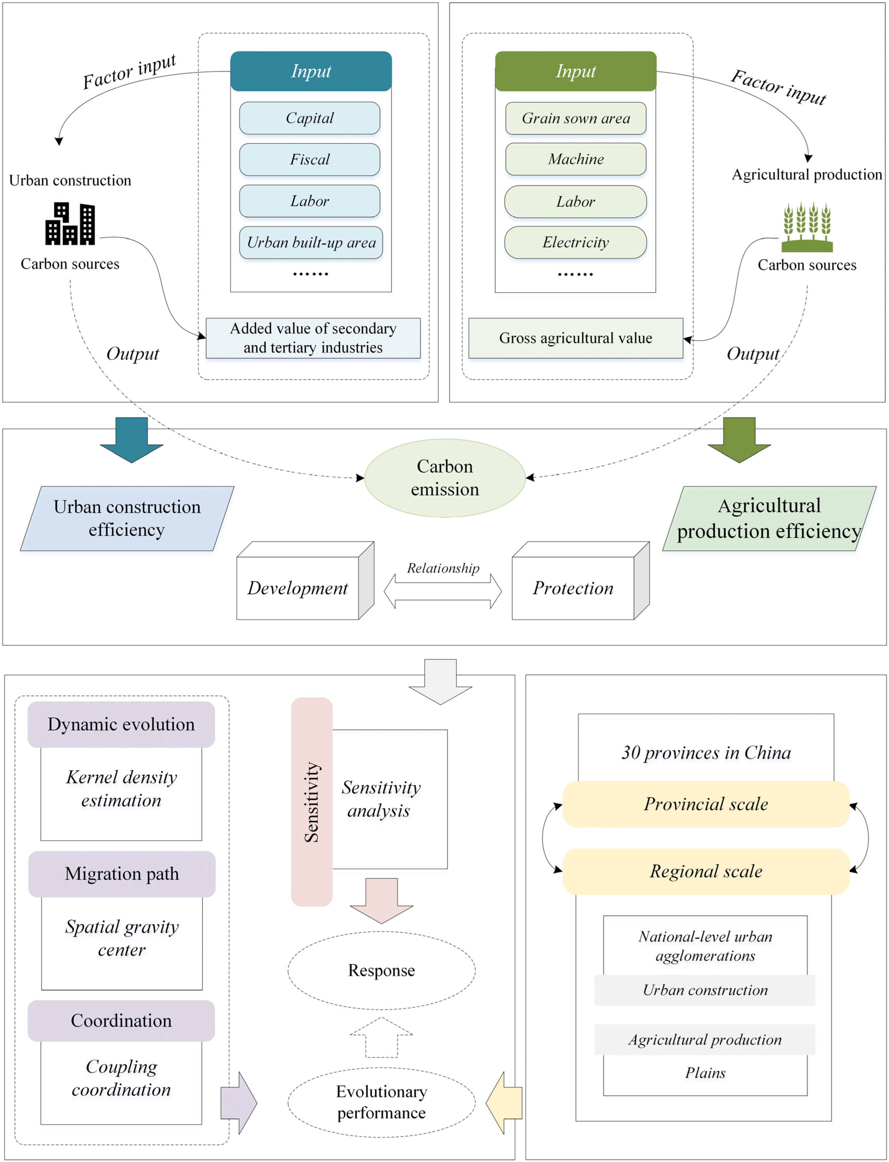
This paper begins by discussing urban and agricultural space and defines territorial space efficiency as urban construction efficiency and agricultural production efficiency. We divide urban and agricultural carbon emissions based on space utilization and focus on the carbon emissions effects of agricultural production. We analyzed the evolution of urban and rural space utilization efficiency and carbon emissions from 1999 to 2019 from three dimensions: dynamic evolution, migration path, and system coordination. At the provincial level, from the perspectives of six national-level urban agglomerations and the four great plains, we analyzed the interaction and influence mechanism of space utilization efficiency and carbon emissions in urban and agricultural spaces. In doing so, we revealed similarities and differences across development trends and responses to urban and agricultural space changes. We also analyzed the reasons for these changes by deeply exploring the relationship between the high-quality development of territorial space and ecological environment governance. We hope to effectively meet national strategic needs.
This research: (1) constructed an analytical framework for space utilization efficiency and carbon emissions, considering spatial and regional effects; (2) reveals differences in the spatial evolution and responses of spatial use efficiency and carbon emissions in urban and agricultural spaces at the provincial and urban agglomeration levels; and (3) proposes targeted high-efficiency and low carbon development strategies according to the analysis of urban and agricultural spaces across regions.
3. Results
3.1. The Dynamic Evolution of Territorial Space Utilization Efficiency and Carbon Emissions
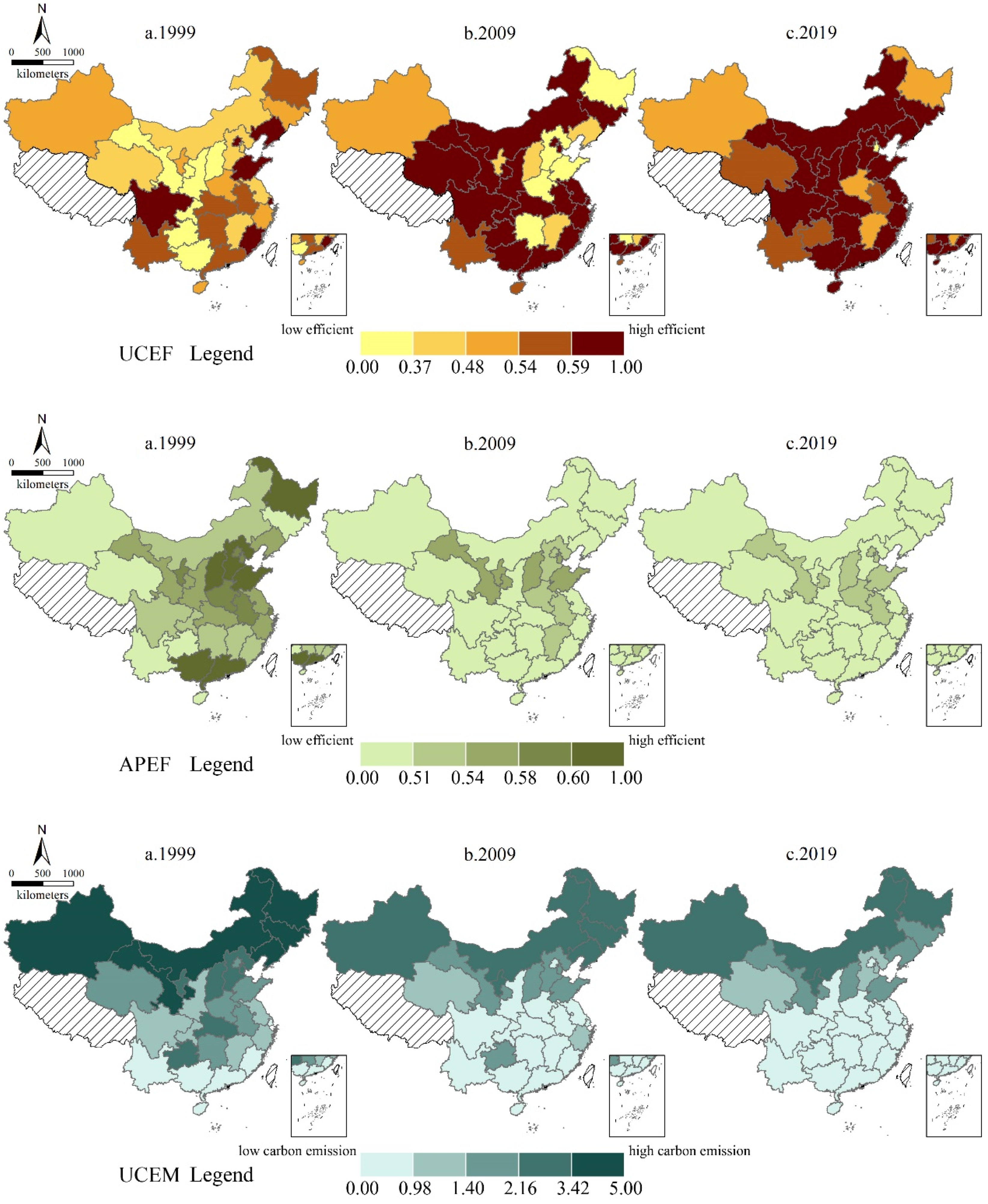
The efficiency of urban construction shows an upward trend from 1999 to 2019, as illustrated in
Figure 3. The spatial distribution is high in the south and low in the north and high in the east and low in the west. This is mainly because, after the reform and opening up, Fujian and Guangdong on the southeast coast implemented a very open policy that has greatly promoted regional economic development, particularly by utilizing the theory of smart growth. Moreover, the northwest region is relatively closed in the hinterland, and its development has been relatively slow. This pattern has continuously strengthened over the past 20 years. Urban construction efficiency in the central region is low, and development is relatively slow. Agriculture is the leading industry in Shandong, Henan, and Shanxi, but these areas have low levels of development of high-tech and other industries, so industrial development is relatively conservative. Urban construction is extensive, and the average land output value is generally low. Heilongjiang, Jilin, and Liaoning are dominated by industries with high energy consumption, such as iron, steel, and coal. The rate of industrial development is insufficient, and the efficiency of urban construction in the later stage is relatively low. Hunan and Jiangxi are located inland and are very weakly influenced by Shanghai.
With the continuous execution of the growth strategy of Central China, the urban construction efficiency of the central region, with Hubei as the core, has significantly improved. By 2019, the urban construction efficiency of 30 provinces reached a relatively high level. In
Figure 3, urban carbon emissions intensity displays a downward trend from 1999 to 2019. In particular, the southeast coastal areas have gradually achieved a balance between high efficiency and low carbon emissions. The urban spatial carbon emissions intensity of Heilongjiang, Jilin, and Liaoning was high, which is inseparable from the leading industries and their high energy consumption. Shandong, Shanxi, and Inner Mongolia are all coal-based structures; the small proportion of clean energy resources and the slow process of transforming their energy structures has resulted in high carbon emissions. Urban construction efficiency and carbon emissions intensity present an opposite evolution pattern; this shows that the high-quality development of urban construction can have a significant impact on the reduction in carbon emissions intensity.
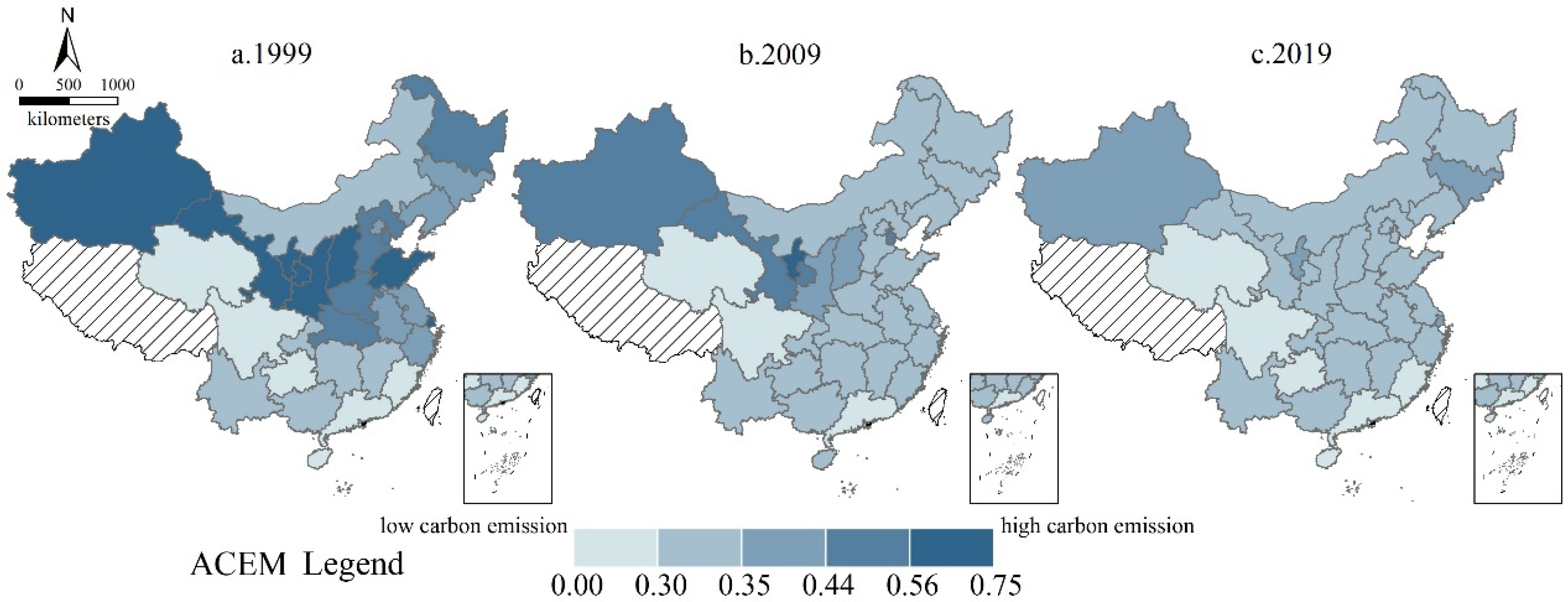
Under the influence of rapid urbanization and industrialization, agricultural production efficiency is declining annually, as shown in
Figure 3. There was a boom in agricultural production in the northeast, central, and southern coasts in 1999. However, the high-latitude geographic location of Heilongjiang, Jilin, and Liaoning makes their temperature a major factor in restricting agricultural production. Hubei, Hunan, Jiangxi, and Zhejiang experienced flat agricultural production, likely because the river network is dense, and the farmland is small in scale, which is not fit for large-scale operations and mechanized production. The higher altitudes in Xinjiang and Qinghai hinder the sunlight and temperature conditions for agricultural production. The urban expansion of Guangdong, Fujian, and Hainan has continuously compressed agricultural space due to the demand for land. Under the influence of factors such as the natural environment and the objective conditions of urban development, the agricultural production efficiency of most provinces is low. Shandong, Henan, and Hebei, among others, have a vast area of arable land, a high degree of mechanization of agricultural production, a long agricultural production cycle, and superior natural and geographical conditions. In 2009, the spatial distribution placed the North China Plain (NCP) at the center, with decreasing activity in the surrounding areas. In 2019, the high efficiency of agricultural production in the NCP gradually became prominent, demonstrating the clustering and distribution of Shandong Province, Henan Province, Anhui Province, Beijing, and Tianjin City.
High-efficiency urban construction is mainly manifested in the high level of regional economic development, the smooth transformation of high-energy-consuming industries, intensive urban construction, and policy support for opening businesses to the outside world. High-efficiency agricultural production mainly benefits from the superiority of natural conditions, the investment in mechanization, and scientific and technological research in agricultural products. Moreover, high carbon emissions are mainly the result of the energy structure and energy consumption, so the regional carbon emissions that are driven by the industrial and energy structure have gradually been effectively controlled. In agricultural spaces, agricultural production factors are the main causes of the increase in carbon emissions. The use of clean factors and circular agriculture can alleviate the increase in carbon emissions to a certain extent. Changes in carbon emissions intensity in agriculture have been similar to the corresponding changes in urban spaces from 1999 to 2019. However, they have different spatial distributions. Notably, the high carbon emissions are also distributed in the central and northern provinces, and insufficient attention has been paid to the low-carbon orientation in agricultural production processes. This shows that China has not yet achieved the coordination of high efficiency and low carbon emissions in agricultural production. The high efficiency of agricultural production depends on a large number of inputs (production factors), which does not meet the inherent requirements for low carbon emissions.
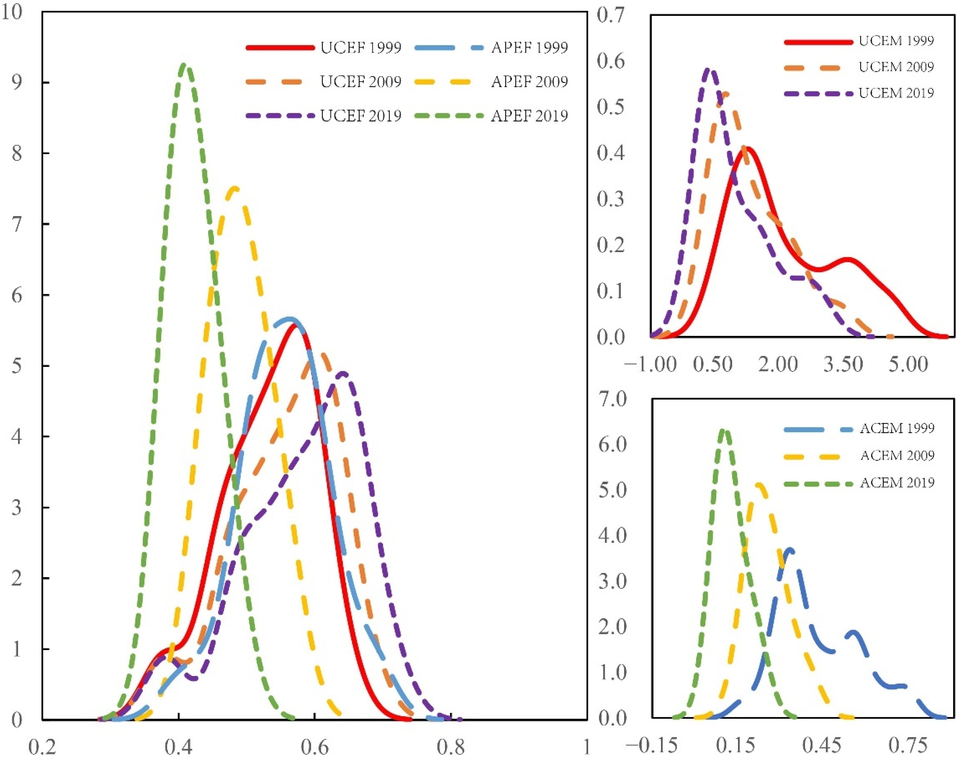
For 1999 to 2019, the kernel density curves of territorial space utilization efficiency and carbon emissions both show significant changes, as illustrated in
Figure 4. The density curve of urban construction efficiency is unimodal, bimodal, and then multimodal. The peak shifts to the right, and the kurtosis on the right decreases, indicating that the high-value area is gradually degrading, showing a state of convergence. The polarization under the state of convergence gradually becomes obvious, indicating that the urban construction efficiency is becoming more compact and developing in a regional agglomeration mode, which fits the development features of cities at different levels in China. The gradual significance of multi-polarization also indicates a rise in the level of coordinated urban development at all levels. The density curve of agricultural production efficiency always presents a unimodal shape. The crest shifts to the left and then rises, while the unimodal shape tends to be compact. The high efficiency value keeps shifting to the left, indicating that the overall agricultural production efficiency is declining, the dominance of regional agricultural production has not undergone large-scale changes, and the dominance is increasingly prominent. This result supports the findings of the previous analysis. The crest of the density curve of urban carbon emissions continues to shift to the left. The shape of the curve moves from bimodal to unimodal, and the unimodal peak is compact, indicating that the intensity of urban carbon emissions has been declining overall. The regional synergy effect is obvious. The agricultural carbon emissions density curve is similar to the urban carbon emissions density curve, and the high value of carbon emissions intensity converges significantly, indicating that carbon emissions intensity in agriculture is effectively controlled.
3.2. Changes of the Spatial Center of Gravity
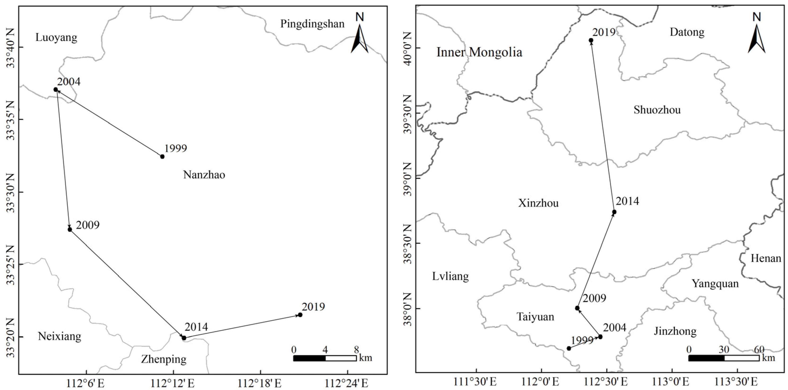
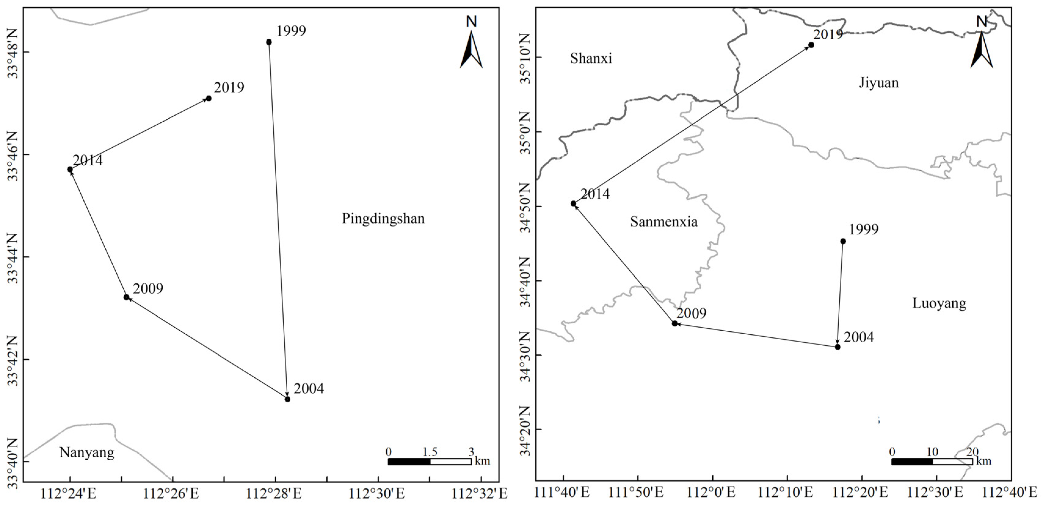
Figure 5 and
Figure 6 show that the center of gravity of urban construction efficiency is around 33° north latitude. The center of gravity of urban carbon emissions intensity is between 37° and 40° north latitude, while the distribution of the two shifts greatly. Analyzing the shift path from 1999 to 2019, we find that the efficiency of urban construction and the intensity of carbon emissions showed obvious opposite migration directions. Although the efficiency of urban construction fluctuates somewhat, it is relatively stable and migrates to the southeast, while the intensity of urban carbon emissions during this period migrates to the north by a large margin. This shows that the high-efficiency and low-carbon model of urban space presents a certain degree of spatial migration matching. This is because high-efficiency urban construction generally reflects a strong regional economy, which provides sufficient financial support for research on and the formulation of clean energy resources. Moreover, the use of new technologies in these areas is ahead of regions with relatively weak economic development. China promotes the strategy of ecological civilization construction, and the region attaches great importance to reducing energy consumption and pollution in the process of production and construction. However, areas with relatively weak economic foundations focus on the construction of infrastructure and cannot account for the ecological environment in the development process. Therefore, there is a mismatch between the two in spatial migration.
The center of gravity of agricultural production efficiency is located at about 33° north latitude. For agricultural carbon emissions intensity, it is between 34° and 35° north latitude. Although the intensity of agricultural carbon emissions is north of the urban space, the offset between the two is relatively small. The migration paths of agricultural space utilization efficiency and carbon emissions intensity are similar; both travel first through the south, then to the west, and finally to the north. This shows that the high-efficiency and low-carbon agricultural space are greatly mismatched. Compared with the universality of urban development, agricultural production varies by region and is concentrated in the large plain provinces. Compared with the ecological governance of urban construction, the low carbonization of agricultural production has a certain lag, and the high efficiency of agricultural production is strongly dependent on the input factors. The formulation and implementation of carbon emissions reduction measures during regional agricultural production are insufficient, and the costs are high. The government’s top-down guidance and policy support are not perfect; thus, high efficiency must be accompanied by high carbon emissions to become the main feature of agricultural production.
3.3. Coordination Analysis of Territorial Space Utilization Efficiency and Carbon Emissions
Based on the spatiotemporal distribution characteristics, dynamic evolution, and migration path, the relationship between the spatial utilization efficiency of agricultural and urban spaces and carbon emissions presents a completely different evolutionary process. Especially in the analysis of the kernel density curve, the multi-polarization of urban construction efficiency and the dominant position of agricultural production show that there are obvious regional characteristics on the basis of provincial differences. Therefore, through quantitative measurement, we further explored the changing process and development of the relationship between the two variables in different regions.
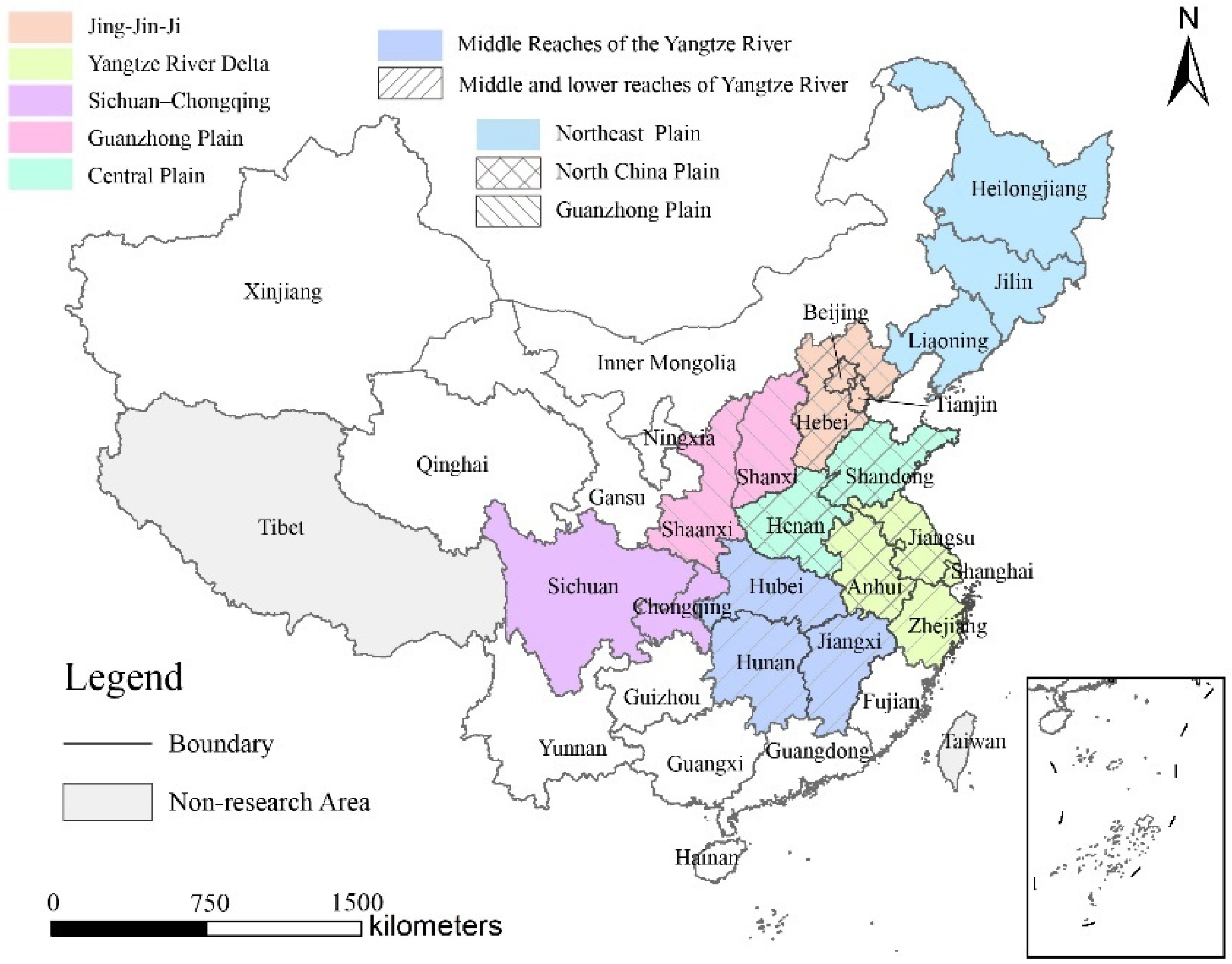
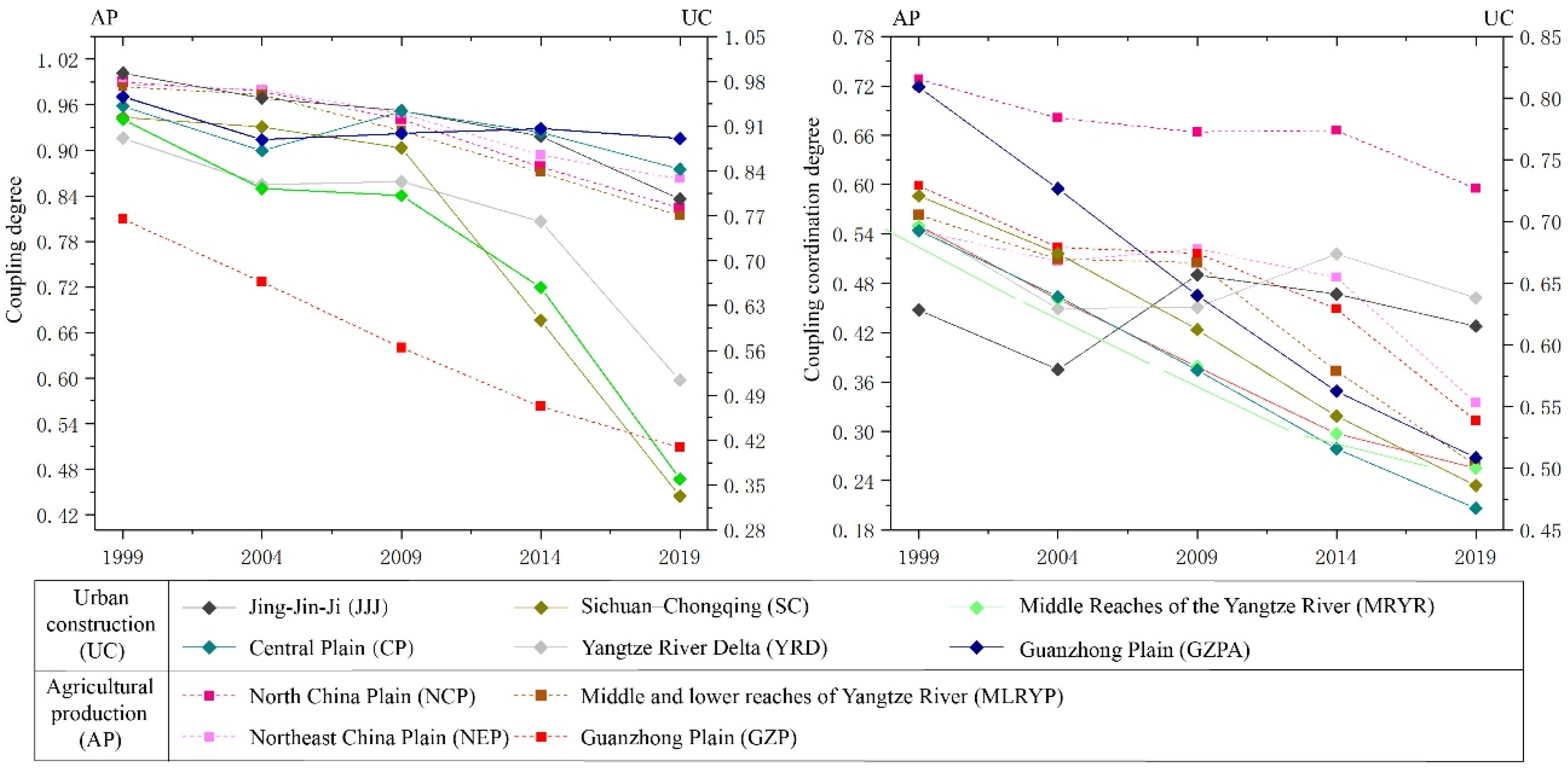
In urban spaces, the overall degree of coupling has shown a downward trend, but there are some differences across urban agglomerations. The urban construction efficiency and carbon emissions coordination level of the JJJ agglomeration far exceeds that of other urban agglomerations, indicating that the capital region, while undertaking political and economic functions, focuses on environmental governance and emphasizes the coordination of development and environmental protection. The degree of coupling in the Central Plain (CP) and the Guanzhong Plain Agglomeration (GZPA) has fluctuated and has certain similarities. The regional economic development of the CP and the GZPA is weak, and urban construction and the ecological environment are in a state of constant trade-off. Therefore, the coordinated development is unstable. In contrast, the YRD is at the forefront of economic development, has a good foundation for development, enjoys preferential policies for reform and external development, and has a relatively stable level of coordination between urban construction and the ecological environment. There are scattered small urban agglomerations within the Middle Reaches of the Yangtze River (MRYR), and it is difficult to integrate and optimize the urban agglomerations. With the deepening of unbalanced and conflicting economic development, this reduction in the level of regional coordination has gradually intensified. The Sichuan–Chongqing (SC) area is located at the junction of the central and western regions. Its imperfect transportation network and other conditions hinder communication, resulting in a low level of coordination between regional urban construction and carbon emissions reduction. The three urban agglomerations along the Yangtze River are relatively low in coupling. However, it is noteworthy that the degree of coupling coordination among the three urban agglomerations dropped drastically after 2014. This may be closely related to the implementation of the regional strategy for the Yangtze River Economic Belt in 2014, which emphasized that the region should “step up conservation of the Yangtze River and stop its overdevelopment”. The shift from development construction to ecological governance has resulted in a sharp decline in the coordination level of urban construction efficiency and carbon emissions.
In agricultural spaces, this research compares the coupling and coordination relationship, as shown in
Figure 7. In terms of the degree of coupling, the interaction between agricultural production efficiency and carbon emissions in the Middle and Lower Reaches of the Yangtze River Plain (MLRYP) and the Guanzhong Plain (GZP) has the strongest impact, and the interaction between the Northeast Plain (NEP) and the NCP has decreased sharply since 2009. The coordinated development level of the four plains has continued to decline. The order of coordinated development from greatest to least is NCP > NEP > MLRYP > GZP. The NCP has superior climatic conditions, the NEP has prominent soil advantages, the MLRYP is rich in heat and water resources, and the GZP has a long history of agricultural production but lacks other advantages. Compared with the relatively stable level of coordinated development in urban spaces, in agricultural areas, there is still no coordination between the high efficiency of agricultural production and the drop in carbon emissions, which is inseparable from China’s rapid urbanization process. Much attention has been paid to the high-quality development of urban spaces, but the coordination of high efficiency and low carbon emissions in agricultural spaces has been ignored.
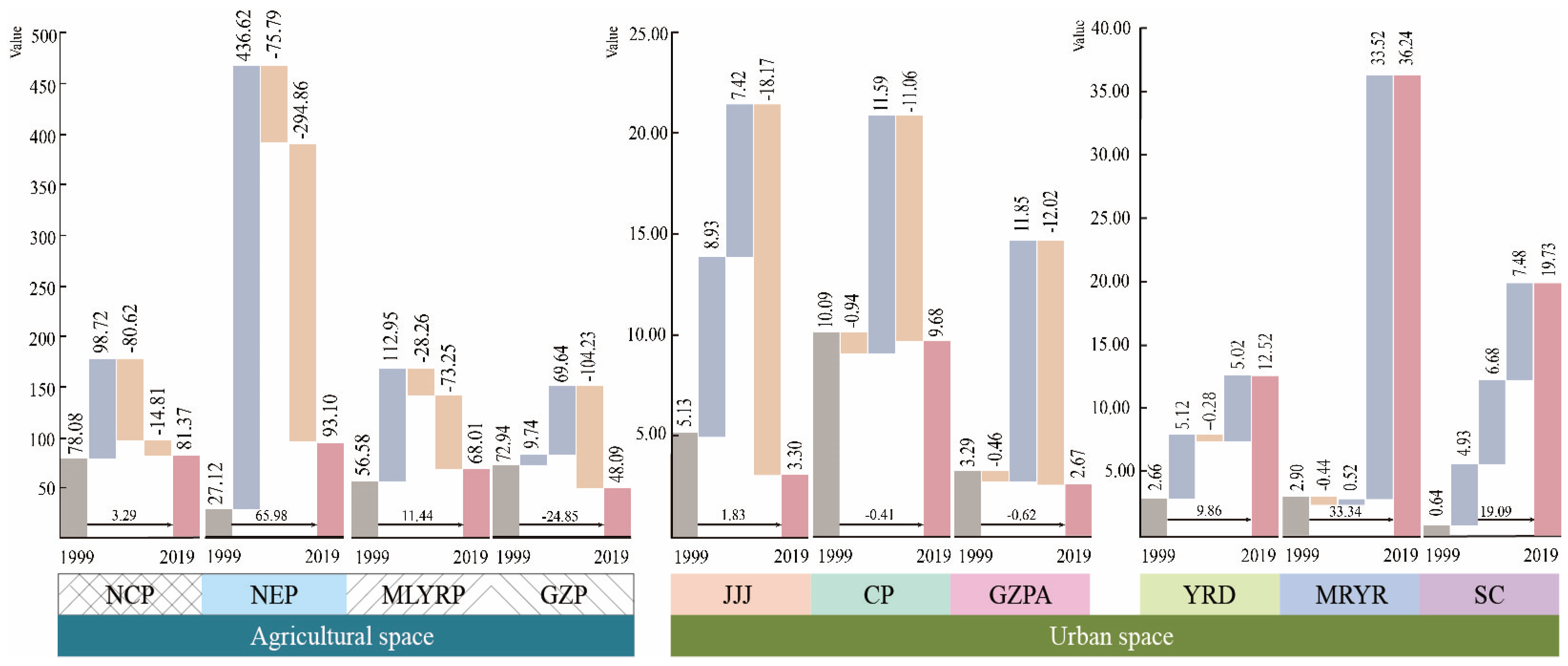
3.4. Sensitivity Analysis of Territorial Space Utilization Efficiency to Carbon Emissions
To explore the relationship between carbon emissions intensity and the change of space utilization efficiency we calculate the sensitivity value of space utilization efficiency to carbon emissions, as shown in
Figure 8. During 1999–2019, the sensitivity of changes in urban space utilization efficiency to carbon emissions intensity increased, with one exception: The sensitivity of urban agglomerations decreased in the Yellow River Basin and increased in the Yangtze River Basin. From 1999 to 2019, the sensitivity of the urban construction efficiency of the six national-level urban agglomerations to carbon emissions intensity fluctuated. The JJJ, the CP, and the GZPA agglomeration in North and West China experienced significant declines after a previous increase, with the largest declines reaching 18.17, 11.06, and 12.02, respectively. The SC, MRYR, and YRD agglomerations along the Yangtze River Basin all show an upward trend, especially the MRYR. Beginning in 2014, the sensitivity of the three major urban agglomerations in the Yellow River Basin began to decline, and the impact of changes in urban construction efficiency on carbon emissions intensity began to weaken. The sensitivity of the urban agglomerations along the Yangtze River continues to increase, as does the impact of changes in the efficiency of urban construction on carbon emissions intensity.
The period 1999–2019 includes two major stages of China’s urban construction. After 2000, China’s urbanization developed quickly. Following the rise of southeast coastal cities, such as Suzhou, Ningbo, Wenzhou, Xiamen, Dongguan, and Shenzhen, heavy industrial cities in Northeast and North China have begun to face the problem of urban transformation. In 2014, China entered a new phase of urbanization. The Chinese government successively proposed a series of major strategies for coordinated regional development. At the same time, ecological governance has gradually received attention, and the unsustainable development model that sacrificed resources and the environment in exchange for economic development was no longer pursued. Regarding the ecological environment, in 2008, starting with the smog in Beijing, China’s environmental issues received extensive attention from abroad for the first time. This is inseparable from the heavy industry in the north, which emits a large amount of smoke and dust. After that, China began to concentrate on environmental governance, especially in its northern cities. However, during this period, the environmental problems of the Yangtze River Economic Belt were not widely recognized, and the chemical industry along the Yangtze River was intensive, which caused serious harm to the environment. In 2014, the guidance on promoting the development of the Yangtze River Economic Belt that relied on the Golden Waterway was promoted by the Chinese government, and the development of urban areas along the Yangtze River Basin has ushered in a new era.
From 1999 to 2019, the sensitivity of China’s agricultural production efficiency changes to carbon emissions intensity fluctuated, showing an upward trend overall. Over these 20 years, the sensitivity of the NEP fluctuated the most. During the period 2004–2009, the sensitivity to carbon emissions intensity in the four great plains increased significantly, indicating that changes in agricultural production efficiency during this period had a very large impact on carbon emissions. Except for the GZP, the sensitivity of agricultural production efficiency to carbon emissions intensity decreased significantly from 2009 to 2014, indicating that carbon emissions intensity was less affected by efficiency changes in agricultural spaces. In terms of the spatial distribution, sensitivity decreased from north to south, and from the NEP to the MLYRP. To ensure grain safety, the Chinese government carried out a “grain subsidy” policy in 2004, and agricultural taxes were abolished in 2006 with the goal of increasing farmers’ enthusiasm for growing food. However, after 2008, the government expanded domestic consumption in response to the financial crisis. A great deal of agricultural land was converted to construction land through land acquisition. This shift in the development focus has gradually weakened the impact of changes in agricultural production efficiency on carbon emissions.
4. Discussion
4.1. Extension of Evolution Characteristics
Strengthening territorial space governance is the important task of sustainable development in the new era. To adapt the new development concept and formulate scientific spatial development policies, the core goal of this research is to reveal the evolution path of high-quality development in the context of China’s territorial spatial planning. Prior research has mainly examined the influence of land urbanization, land use transformation, and urban spatial structure on carbon emissions, focusing on a single land type. Zhang [
56] and Xu argued that land urbanization reduces carbon emissions, but compared with other determinants, its impact is small. Chuai et al. [
57] showed that in the land use transformation process, the conversion of cultivated land to construction land contributes the most to carbon emissions. Liu et al. [
25] indicated that the compactness of urban space increases carbon emissions. However, it is not enough to study only land elements and a single space, and a more comprehensive understanding is needed. For example, few scholars discuss the impact of space utilization on carbon emissions, and the scholarship lacks comparisons of different utilization spaces and analyses of regional differences. This paper separates urban and agricultural spaces and focuses on the comparison of space utilization efficiency and carbon emissions in these different spaces to reveal their evolution paths. The research pays special attention to areas with low efficiency and high carbon emissions and provides targeted countermeasures, which can serve as references for the formation policies that will drive high-quality development across regions.
The spatial and regional evolution analysis produced some interesting findings. Comparing different spaces, China’s urban construction and agricultural production are basically distributed according to important functional areas, but in the density curve, urban construction shows a multi-polar distribution, while agricultural production is always unipolar. This is no doubt related to the geographical location, industrial policy, and development opportunities of the region. From the perspective of policy formulation, China has formulated strategies that are suitable for regional development based on important river basins and urban agglomerations, but it has not yet formulated an agricultural development strategy based on regions, nor has it concentrated enough on the carbon emissions effects in agricultural spaces. Zhao et al. [
15] estimated that agricultural carbon emissions in China increased by 21.89% from 2005 to 2013, while Guo et al. [
58] estimated that China’s agricultural production efficiency declined from 2000 to 2015, which is consistent with the findings of this paper. The spatial center of gravity migration found that in agricultural and urban spaces, the space utilization efficiency and carbon emissions migration are opposite, especially in agricultural space, which presents a spatial matching of high efficiency and high carbon emissions. Under the influence and impact of urbanization, the development of agricultural space lags behind that of urban space. The high-quality development of agricultural space cannot be ignored. Moreover, high-quality agricultural production is oriented toward precision rather than breadth, which indicates that the improvement of high agricultural production efficiency requires top-down policy guidance.
Comparing the features of different regions, Yu et al. [
59] found that urban agglomerations have become a complex urban system, and the land use efficiency between urban agglomerations has obvious characteristics of spatial heterogeneity. Especially in the distribution of sensitivity, the sensitivity changes of different urban agglomerations in urban space are divided into two significant groups. In addition to the JJJ agglomeration, these two groups are located along the Yangtze River Basin and the Yellow River Basin. This shows that rivers, as the birthplace of culture and a communication link, play a significant role in connecting regional development. Although the JJJ agglomeration is not located along the Yellow River Basin, it is near the GZPA and the CP agglomerations, which show similar changes in sensitivity. Space utilization and carbon emissions are different in urban and agricultural spaces, and the distribution along the watershed is heterogeneous, which indicates that the research on the environmental effects of space utilization should concentrate on the scale and spatial effects of the study.
4.2. Policy Implications of Coordination and Sensitivity
Development and protection are the two major propositions of territorial space governance. Paying attention to the coordinated trend of the two and the influence of development on the ecological environment is key to realizing sustainable socio-economic development. In response to the sustainable development of territorial space utilization and carbon emissions, the government should formulate more targeted policies to solve current problems.
The urban space utilization efficiency of the JJJ, the CP, and the GZPA have low sensitivity to carbon emissions. This shows that, after the urban construction efficiency reaches a certain stage, for the JJJ, the CP, and the GZPA, the impact of urban construction efficiency on carbon emissions begins to decline. In terms of the factors that affect carbon emissions, the focus should be placed on the supply and consumption of energy in all aspects of production and construction. The urban agglomerations along the Yangtze River are developing rapidly, and the contradiction between urban construction and ecological governance is obvious. The use of urban space should clarify the development positioning and functions of the town and effectively integrate the urban spatial layout. For example, in urban agglomerations or urban circles, it is necessary to integrate the types of industries in the region, expand their scale and agglomeration effects by optimizing the layout, fully consider the balance of occupation and residence in urban space, and reduce large-scale population flow at peak times (e.g., the end of the workday). Rebar, cement, construction, and other industries are crucial to national economic development, and they are the major industries with high carbon emissions. By increasing investment in clean energy and optimizing the energy composition, carbon emissions can be effectively reduced. Furthermore, the transition from low-end industries to high-end industries can effectively increase the efficiency of regional urban construction and achieve a win–win bridge of high efficiency and low carbon emissions. In addition, for the Yangtze River Economic Belt, the government should always insist on protection, refrain from large-scale regional development, strictly abide by the ecological red line, strictly prohibit activities such as reclaiming land from lakes, prioritize ecological conservation, and enhance the carbon sink capacity of the ecosystem.
In terms of sensitivity, the agricultural space shows the opposite result from the urban space. The impact of changes in agricultural production efficiency on carbon emissions intensity is becoming increasingly important, and the sensitivity decreases from north to south. This shows that the level of agricultural production still needs to be improved. First, rapid urbanization in China has occupied a large area of agricultural land around cities and towns. A large number of “occupation–compensation balance” policies have “accounted for the advantages and compensated for the disadvantages”, which has seriously damaged the quality of cultivated land. In addition, China has proposed to strictly observe the red line of 1.8 billion acres of cropland, delineate the line of permanent basic farmland protection, and strengthen the bottom line of cropland protection; however, the country’s emphasis on agricultural production mechanization, informatization, and modernization is still insufficient. Furthermore, the input elements in the production process will directly or indirectly increase carbon emissions. However, developing circular agriculture, promoting reciprocating multi-layer utilization and the efficient flow of various agricultural resources, and improving resource utilization efficiency will help. The input of agricultural production factors increases carbon emissions, and the harm to agricultural land should not be underestimated. The development of new materials can reduce damage to the land and pollution by changing the input elements and constructing high-quality farmland to improve the quality of cultivated land. In addition, through the transfer of agricultural land, a centralized contiguous area of agricultural land is formed, and large-scale operation and mechanized production is realized. This will effectively improve agricultural production efficiency under the low-carbon orientation from both the agricultural land itself and the external technology input.
4.3. Limitations and Future Research Directions
Owing to the constraints on data acquisition, this study used provincial administrative regions as the research unit, and consideration of regional differences within the provincial unit was insufficient. If research can be carried out at the city or county level, it will provide more precise recommendations for regional policy development. In this study, the basic indicators, such as land, labor, and capital, were used in the calculation of space utilization efficiency. However, the factors affecting space utilization efficiency are various, and the process of measuring them is complicated. Future research should explore the impacts of multiple agents on space utilization and form a richer analysis. In addition, to better characterize the impact of territorial space utilization efficiency on carbon emissions intensity, follow-up studies should improve the spatial analysis methods.
5. Conclusions
In the new era, the governance of territorial space is based on spatial divisions to identify problems and formulate strategies. The dominant areas of urban construction and agricultural production are neither independent nor consistent. In adapting to the sustainable development of territorial space, there is a lack of an analytical framework that considers differences in the high-quality development and evolution paths that take into account the division of space. Exploring the optimal path for the efficient development of urban and agricultural space with a low-carbon orientation would significantly contribute to the analysis and can help improve policies that drive high-quality regional development.
This research established an analytical framework for spatial evolution and role identification for urban and agricultural space utilization efficiency and carbon emissions from 1999 to 2019. It used the KDE model and the center-of-gravity model to identify spatiotemporal differentiation. Based on the coordination analysis model and the sensitivity model, we analyzed the coordinated development-level changes of space utilization and carbon emissions and the response of carbon emissions intensity to changes in space utilization efficiency. The construction of this research framework helps to reveal differences in the evolution paths of space utilization efficiency and carbon emissions in different spaces and regions, and more importantly, it supplements the current regional economic development and ecological governance policy formulations.
The results indicate that the spatial center of gravity of space utilization efficiency and carbon emissions show diametrically opposite migration directions in urban and agricultural space. The coordinated development levels of the two show a downward trend, but there is explicit spatial heterogeneity across regions. Besides the spatial effect, the response of carbon emissions intensity to changes in spatial utilization efficiency has obvious regional effects along the Yellow River Basin and the Yangtze River Basin. Especially for the high-quality development of agricultural space, it is important to understand how we can achieve a win–win situation with high efficiency and low carbon emissions. We argue that the government should strengthen the formulation of agricultural production planning and the integration of resources, as well as top-down policy guidance. The results provide support for the formulation of high-efficiency development policies under the low-carbon orientation of urban agglomerations and plains. Additionally, there are some limitations of the study that must be resolved in future work. Further research at the city and county levels should be carried out in the future to enrich the research results. In addition, future studies can use spatial utilization efficiency under multi-agent decision-making and more complete space analysis models to further explore the interaction between and future trends of high efficiency and low carbon emissions.


