Article

Introducing Management Actions to Unmanaged Campsites in Daisetsuzan National Park, Japan: A Discussion Based on a Reservation System in Taiwan’s National Parks

1
Graduate School of Environmental Science, Hokkaido University, Sapporo 060-0810, Hokkaido, Japan
2
Faculty of Environmental Earth Science, Hokkaido University, Sapporo 060-0810, Hokkaido, Japan
*
Author to whom correspondence should be addressed.
Land 2022, 11(3), 337; https://doi.org/10.3390/land11030337
Submission received: 18 January 2022 / Revised: 16 February 2022 / Accepted: 21 February 2022 / Published: 24 February 2022

Abstract

:
A limit on use is often practiced overnight in mountain national parks to reduce users’ environmental impact on campgrounds and cabins or huts, where they spend most of their time. This study aims to propose an appropriate management system to mitigate the problems observed in Daisetsuzan National Park’s unmanaged campsites. We looked into three mountain national parks in Taiwan to learn about an established campground reservation system. We collected information on campgrounds and cabins in these three national parks through a literature review and internet surveys. The distribution of campgrounds and cabins was mapped using ArcMap 10.8.1. They effectively reduced the distance between adjacent campgrounds and controlled each campground’s area. This was done by tolerating some informal sites among online reservable campgrounds. The results of the interview surveys with the three park managers showed that the reservation system helped reduce the crowding problem. Introducing a lenient reservation system, with the support of related stakeholders and park users, would be a promising option to mitigate soil erosion and overuse problems in campsites in Daisetsuzan National Park’s alpine zone and in other campsites in fragile environments worldwide.

1. Introduction

Trekking and camping are the main recreational activities in mountain parks. Campgrounds and cabins or huts are often located along the trails in remote alpine areas to meet overnight park users’ accommodation needs. The environmental impact caused by accommodation use in campgrounds and cabins or huts cannot be avoided [1]. National park managers need to keep such an environmental impact within acceptable limits. A limit on use was practiced in many backcountry areas in the USA, especially for overnight users who usually spend more time in the parks, to minimize the camping impacts on the fragile environment and reduce crowding problems.
Camping activities’ impacts include loss of vegetation, expansion of bare ground, and soil erosion. Previous studies [2,3,4] revealed that campgrounds lost almost all of their vegetation cover in their first two years of use. A previous study has found that campgrounds can be severely impacted even if they are used for only 15 nights every year [5]. Constant camping activities lead to a bare ground expansion under unmanaged conditions [6]. Meanwhile, the formation of a complex informal trail network resulting from campers’ movement (e.g., to expand their camping footprints by moving between nearby sites; or to search for toilets) is a major problem in undeveloped camping areas [7,8,9,10,11]. Particularly, the quality of users’ camping experience is usually influenced by the existence of such impacts at sites with high-level use [12,13,14,15].
The containment strategy has been widely adopted on campgrounds in American national parks. In these parks, soil erosion and deteriorated camping experience were observed to concentrate camping in a limited number of tent sites (e.g., individual camping spaces with platforms or tent pads). Therefore, the impacts caused by site proliferation are reduced [13,16,17,18,19]. Containment has been recognized as an especially effective strategy in minimizing users’ environmental impacts on heavily-used campgrounds [5,17,20]. In Shenandoah National Park wilderness, the area of bare ground in campgrounds decreased by 50% after the shift from a dispersed camping strategy to a containment camping strategy in which campers were advised to use designated campgrounds [17]. Moreover, the introduction of platforms and tent pads has further minimized the said environmental impacts [21,22,23]. Especially the side-hill tent pads on sloping terrain can effectively concentrate camping use and avoid site expansion. It was found that the mean area of campsites with side-hill tent pads is 68% less than that of campsites on flat ground [23]. The introduction of tent platforms to the major alpine campsites in the Eastern Arthur Range since the 1990s has not only successfully confined camping to a few areas, but also drastically reduced soil erosion at the campsites [7]. As one of campgrounds’ attachment facilities, shelters have also taken a significant effect on concentrating camping use [16]. Such “active management” is scientifically supported by the results of research on campground management [9]. In fact, research on this area of study has been increasing since the 1980s, mainly in the USA. However, concentrating use through a containment strategy without any limitations on use can cause crowding problems. It has also been reported that containment strategies can negatively affect the quality of users’ experiences [21].
One way to solve the crowding problem on campgrounds is to introduce a reservation system. A previous study tested an advanced reservation system for campgrounds at an early period in the Denali National Park and Preserve to meet users’ desires [24]. However, a high proportion of users who did not show up on the reservation date forced managers to return to management on a first-come first-served basis. In recent years, reservations of multiple recreational activities have been widely introduced in national parks and other protected areas across the world. This was done because of an increase in recreational demands and accompanying crowding problems that frequently occur. Various reservations related to recreational activities (e.g., campground and wilderness permit reservations) in the most crowded national parks in the USA (e.g., the Great Smoky Mountains National Park and Yosemite National Park) can be made through a government website (recreation.gov; accessed on 20 October 2021). This is expected to solve the overcrowding problem during the peak season [25].
In the USA, each national park has its own headquarters under the responsible authority, that is, the National Park Service. The management of campgrounds in each national park is conducted by the corresponding headquarters. At this point, 29 national parks (46%) in the USA have introduced backcountry campground reservations. Among them, the reservable backcountry campgrounds in 15 national parks can be booked through a common website, “Recreation.gov (accessed on 10 February 2022).” In Canada, Parks Canada (the responsible authority of the national parks) provides a reservation system that covers backcountry campgrounds in 20 national parks (43%). Users can reserve a campground either by making a call to the office or through Parks Canada’s online Reservation Service, where users can search for the availability of campgrounds in all the national parks. In Taiwan, among nine total national parks, an online reservation system for backcountry campgrounds is only available for the three national parks surveyed in this study.
Meanwhile, Japan has many mountainous national parks that have been heavily used by visitors. Daisetsuzan National Park in Hokkaido, the country’s northernmost island, is an example of a national park with crowding and soil erosion problems [14]. The reservation system has not yet been introduced to the park. Such a system is still uncommon in Japan’s national parks. Campground reservations is limited to only a few campgrounds in Japan’s mountain national parks (e.g., Chubusangaku National Park). The reason most campgrounds in the alpine zone in Japan are not managed is not well understood. However, one possible reason could be related to the fact that most lands in national parks are not owned by the responsible authority, that is, the Ministry of the Environment. In most cases for national parks located on the main islands of Japan (with the exception of Hokkaido), the campground management is conducted by an individual cabin owner who maintains a cabin next to the campground. Therefore, the cabin owners decide whether to introduce a reservation system. Traditional thoughts consider adding a human touch to nature as destructive, and many people believe that the best way to protect nature is to touch it as little as possible. This general view might also have contributed to passive campground management in the mountainous national parks of Japan. In contrast, Taiwan’s management of mountainous national parks is modeled after that of the USA, which may have led to the introduction of proactive management.
Research on carrying capacity has a long history in the recreation ecology field [26,27]. For example, recreational activities such as trekking and camping are very popular in Taiwan’s mountain national parks. High rates of visitation have caused crowding problems in some popular campgrounds. Thus, studies on the carrying capacity of each national park have been conducted since the late 1980s to improve ecosystem conservation and user experience. Based on the results, a restriction on the number of people allowed to enter ecological-protected areas and a reservation system for campgrounds was introduced in 1999 [28,29]. A series of carrying capacity estimations based on a scientific assessment of social and environmental impacts are helpful for managers when introducing any limitation on the use. Moreover, the following actions are useful for rationing use: advance reservation and first-come first-served system [9,30,31,32,33,34,35]. However, even in parks where reservation systems have been well established (e.g., Banff National Park in Canada, Cradle Mountain–Lake St. Clair National Park in Australia, and Taiwan’s mountain national parks), little research has been done on these systems. Thus, their effectiveness is not well understood.
There are 12 unmanaged sites in the alpine zone of Daisetsuzan National Park where people can camp. The Ministry of the Environment (MoE) clearly distinguishes these unmanaged camping sites as “Yaeishiteichi” or “campsites,” and managed camping sites as “campgrounds.” In Daisetsuzan National Park, campsites are in the alpine zone and campgrounds are located at low altitudes. Soil erosion and bare ground expansion, which have been frequently seen on trekking trails [36,37,38], were also observed on the campsites [14] without formal management. Overuse occurred on some popular campsites during weekends. Some tents even overflowed to the surrounding trekking trails, becoming a major problem [14]. For this reason, it is important to introduce a park management system. The same system can be adopted in other mountain national parks in Japan.
It is important to investigate the campground management of overseas national parks where a reservation system has been established to discuss the necessity of introducing a reservation system to campsites in Daisetsuzan National Park and to promote sustainable management. For this purpose, we selected three national parks in Taiwan. These national parks have reservation systems with slight differences. Moreover, they employ lenient management which coincides with the gentle trail management system adopted by the partnership in many national parks in Japan. Therefore, we aimed to identify the opportunities and constraints of introducing a reservation-based management system to the campsites in Daisetsuzan National Park based on an analysis of solutions that have been adopted in the three national parks in Taiwan. As mentioned earlier, the reservation system has not been studied much as we speak. This study’s discussion will be beneficial to managers working in mountainous national park areas around the world.

2. Materials and Methods

2.1. Study Areas

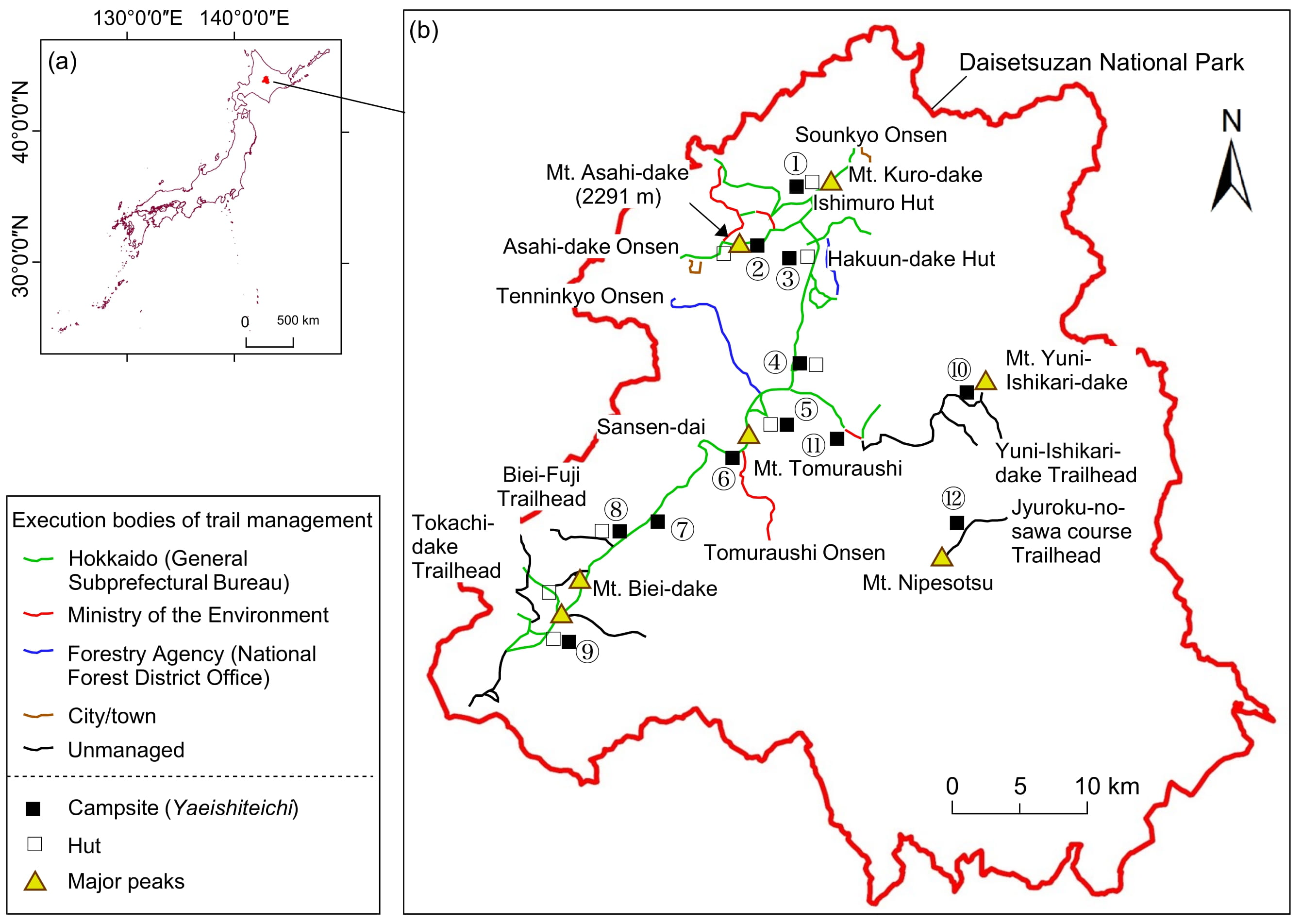
2.1.1. Daisetsuzan National Park

Daisetsuzan National Park is a representative mountain national park in Japan. It has an area of 2267.64 km2, covering one city and nine towns (Figure 1). There are 38 peaks above 1500 m. In these areas, alpine landforms, flora, and fauna are widely distributed. The highest peak, Mt. Aasahi-dake (2291 m), is often called the roof of Hokkaido. Trekking and camping are heavily seasonal. Particularly, these activities are limited to three months from the end of June until the end of September. There are eight huts for emergency use in the alpine zone. Among them, two huts (Ishimuro hut and Hakuun-dake hut) also provide accommodation during the camping season. Long-distance overnight trekkers use 12 campsites (Figure 1) at most when they are staying in the area. The most popular campsite is the Kuro-dake campsite (Figure 2). During the camping seasons from 2016 to 2020, around 104,540 users on average enter the mountains per year (Figure 3).
In Daisetsuzan National Park, trails were classified into five grades (Grades 1–5). This grading scale is called the Daisetsuzan Grade [39,40,41], which was launched in 2015. Based on this scale, trails of higher grades are of greater significance for nature conservation and are less facilitated. However, high-grade trail sections are usually difficult to access because of the long walking distance and their rugged terrain. Trekkers planning to enter the trail sections with high grades (e.g., Grades 4 and 5) should be equipped with professional trekking gear. Furthermore, they must always be prepared for extreme weather or other emergencies.

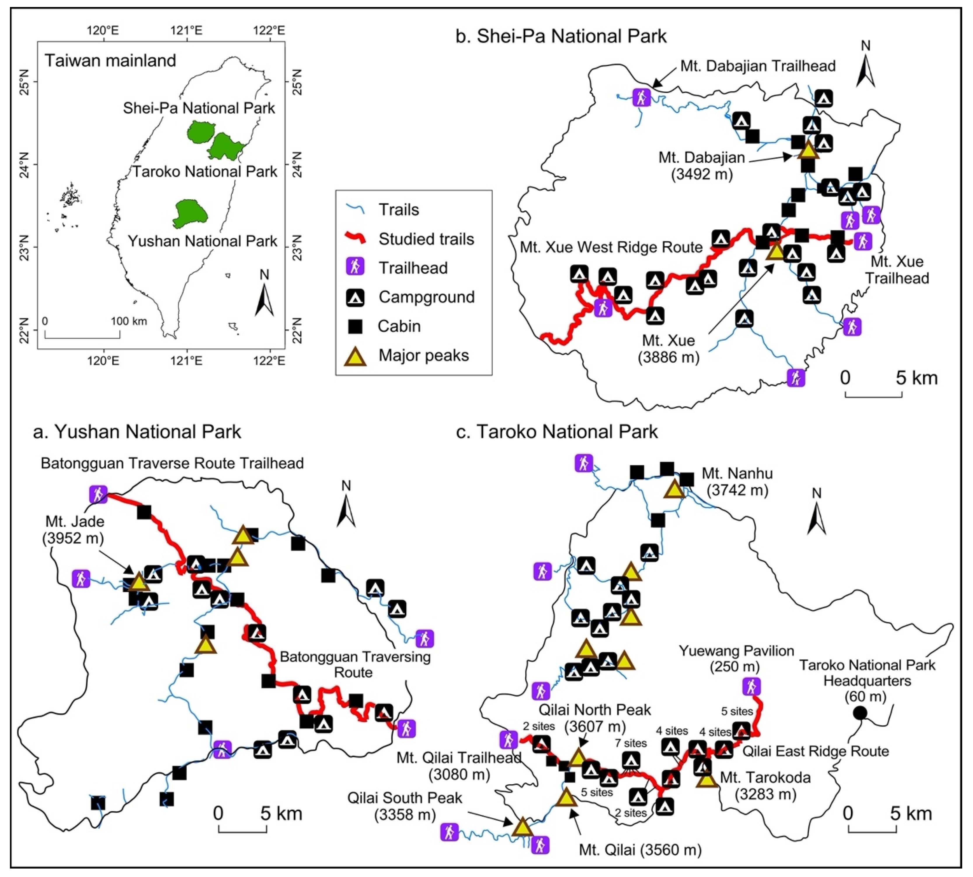
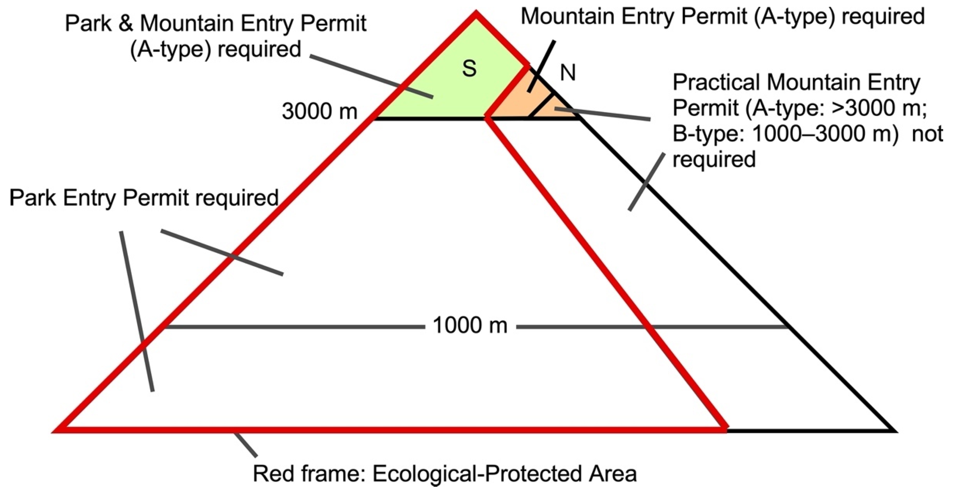
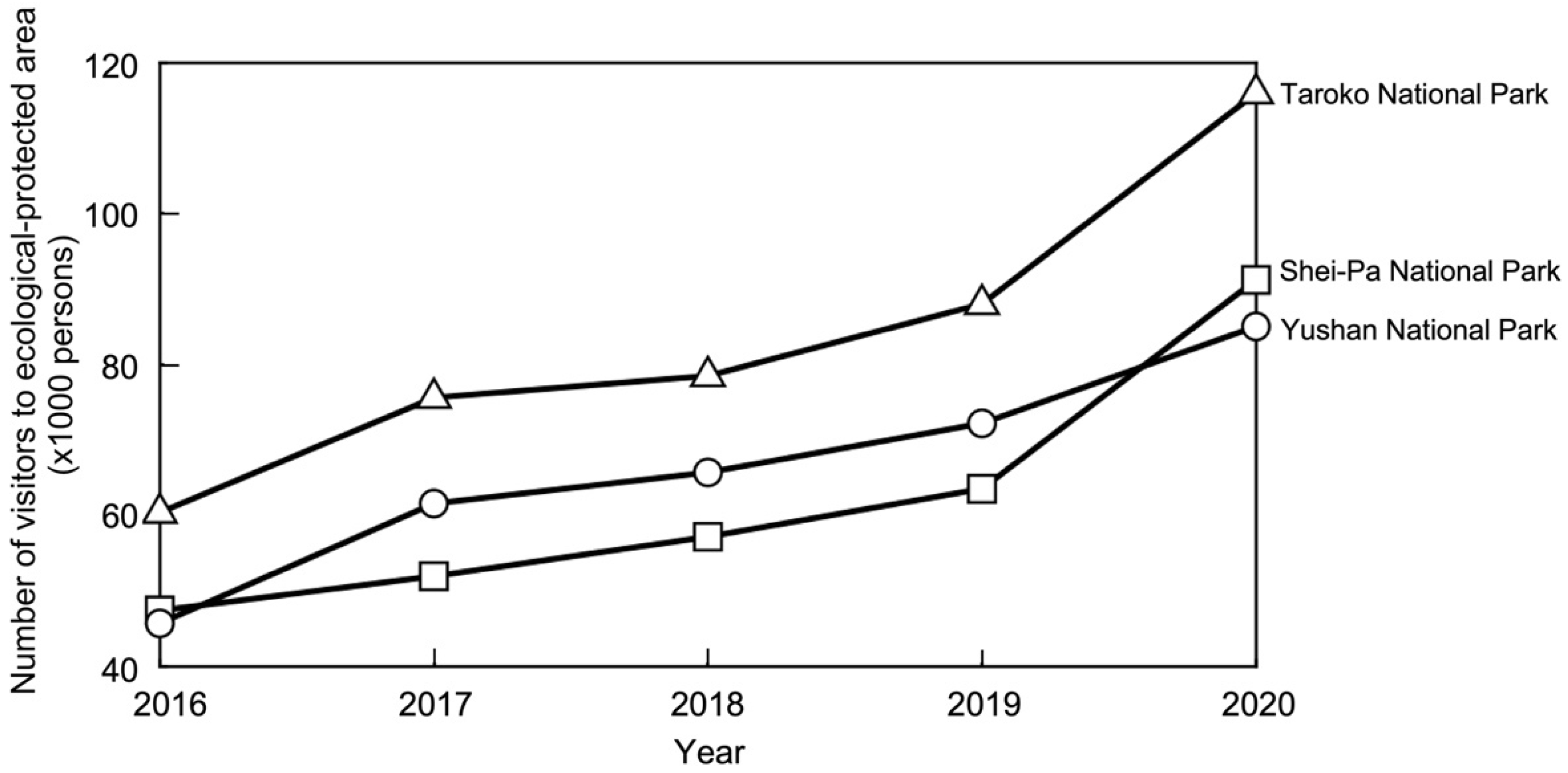
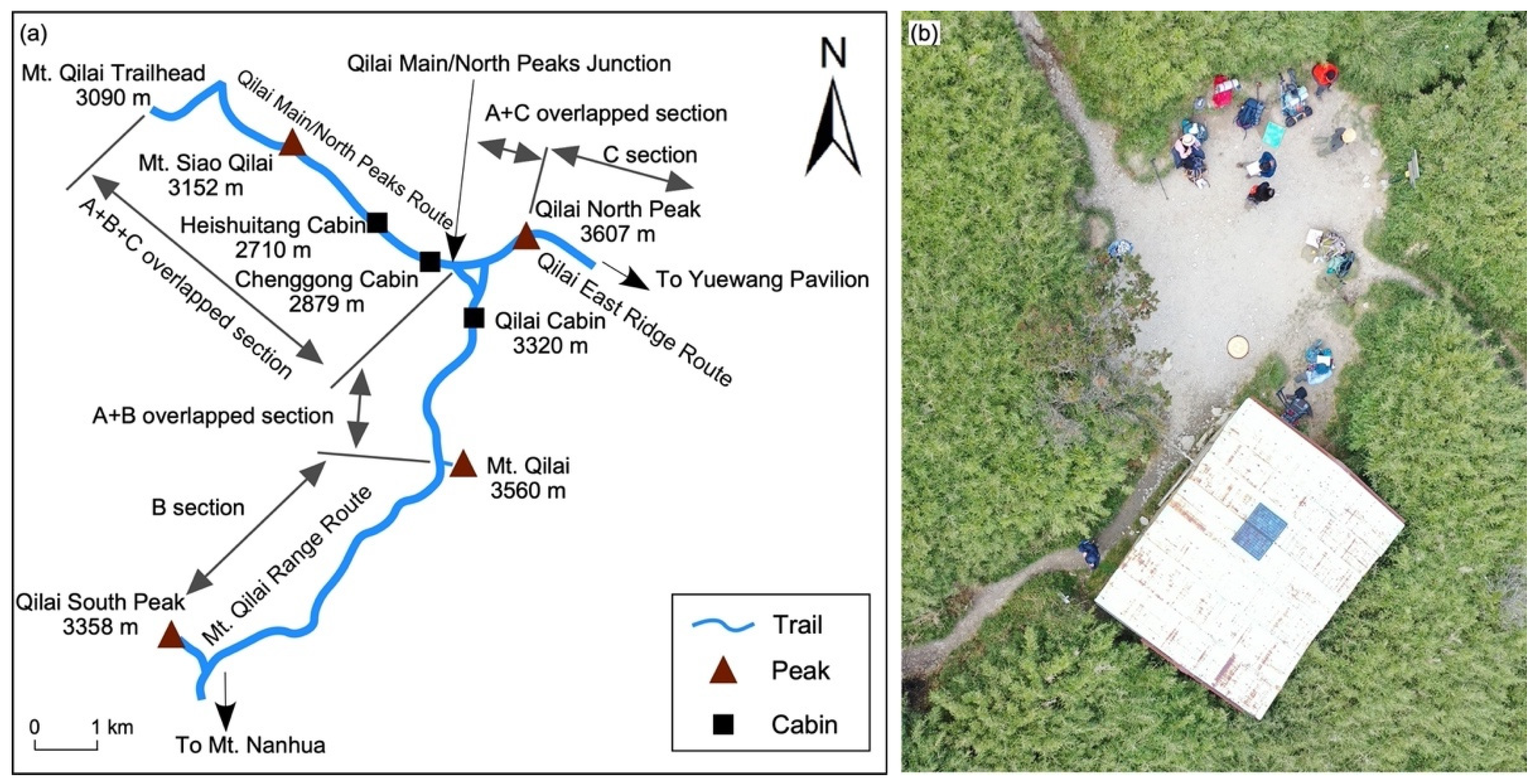
2.1.2. Three National Parks in Taiwan

Yushan, Shei-Pa, and Taroko are the three representative mountain national parks with alpine zones in Taiwan (Figure 4). Among these three national parks, Yushan National Park (1031.21 km2) is home to Taiwan’s highest mountain, Mt. Jade (3952 m). This mountain has 29 peaks over 3000 m. On the other hand, Shei-Pa National Park (768.50 km2) is home to Taiwan’s second-highest mountain, Mt. Xue (3886 m). It likewise houses Mt. Dabajian (3492 m). These mountains are the two symbolic peaks of the park. In total, the park has 51 peaks over 3000 m above sea level. Many trekkers visit the park on weekends because of its proximity to Taipei City. Taroko National Park covers an area of 920 km2. It includes a wide range of vegetation zones from subtropical (coastal areas) to alpine zones. Mt. Nanhu (3742 m) is the highest peak in the park. In total, the park has 48 peaks over 3000 m above sea level. These three national parks are open for camping all year-round even though the alpine zones are covered with snow in winter.
Park planning was created for Taiwan’s national parks pursuant to the National Parks Act of 1972. According to park planning, areas in national parks are divided into five different categories: ecological-protected areas, scenic areas, cultural and historic areas, recreation areas, and existing use areas. Each area is managed differently based on its function and resource conservation’s significance. More than 60% of the areas in Yushan, Shei-Pa, and Taroko National Parks are ecological-protected areas. All campgrounds in the alpine zone of these three national parks belong to ecological-protected areas. Here, users are required to apply for a park entry permit and a mountain entry permit based on the National Parks Act (Figure 5). In Taiwan, mountains over 3000 m above sea level are referred to as “high mountains.” In this study, the three national parks with “high mountains” have different requirements for one to obtain an entry-permit application, as shown in Figure 5. Users should apply for park entry permits and mountain entry permits online in advance. Moreover, they should make reservations for campgrounds and cabins if they wish to conduct overnight trekking trips. Similar to Daisetsuzan National Park, the three national parks in Taiwan allow camping in remote alpine zones. Therefore, a good understanding of the methods that they use to handle the reservation for the campgrounds in remote mountains and the problems they encounter can provide guidance for introducing a reservation system to Daisetsuzan National Park.
The mean annual number of visitors (2016–2020) of the three mountain national parks’ ecological-protected areas reached 66,099 (Yushan National Park), 62,317 (Shei-Pa National Park), and 83,720 (Taroko National Park), respectively (Figure 6). A sharp increasing trend was observed, even during the COVID-19 pandemic.

2.2. Methods

2.2.1. Methods Used for Daisetsuzan National Park

The main trails’ polylines, campsite points, and main trailheads were created based on the online georeferenced aerial photographs provided by the Geospatial Information Authority of Japan (GSI). The polylines, campsite points, and trailheads in the web map system of GSI can be exported to KML files in the geographic coordinate system, JGD 2011. We converted the KML files into shapefiles using ArcMap 10.8.1 and projected the shapefiles of trails in a projected coordinate system, WGS 1984 UTM 54 N. Then, we measured the distance between the two nearest campsites and the distance between a campsite and a major trailhead using the geometry calculation function to identify the distribution of campsites in Daisetsuzan National Park. Each campsite’s altitude was confirmed based on a Digital Elevation Model of 10-m resolution provided by GSI to identify the vertical distribution of campsites in mountains.
A questionnaire survey was conducted in 2019 and 2021 to identify users’ opinions on introducing tent pads and tent platforms to the campsites in Daisetsuzan National Park. The question, “Do you agree with the introduction of tent pads/tent platforms into the campsites in Daisetsuzan National Park?” was asked to the respondents. During the survey, we showed the photographs of two different types of tent pads and one wooden tent platform and asked the respondents about their preferences on a 5-point Likert scale. In total, 56 effective responses were collected through a face-to-face survey performed at the Kuro-dake campsite (11–13 August 2019 and 30 August–3 September 2019). On the other hand, 133 effective responses were collected through an online survey by distributing QR access codes to the users at the Sounkyo Onsen (18–19 September 2021) and to the local trekkers’ community members (April–September 2021). We only chose the people who bring camping equipment with them as targets when distributing the QR access codes. Therefore, the respondents have either camped in mountains (e.g., respondents at the Kuro-dake campsite and local trekkers’ community members) or are going to camp in Daisetsuzan National Park.

2.2.2. Methods Used for Taiwan’s National Parks

We conducted a literature review and an internet survey to collect information about the availability of campgrounds and cabins in the Yushan, Shei-Pa, and Taroko National Parks. The scanned official maps of the three national parks were georeferenced by inputting coordinates of Ground Control Points (GCPs) as shown on the official maps in ArcMap 10.8.1. Ten evenly distributed GCPs were used for georeferencing each map. Based on the location data of campgrounds and cabins collected from official maps of the three national parks and an official document of informal campgrounds in Taroko National Park, we created maps of the distribution of accommodation facilities in each national park’s alpine zone (including some subalpine-zone areas). The maps created in ArcMap 10.8.1 were all projected in WGS 1984 Web Mercator Auxiliary Sphere for conducting the following length measurement. We selected one representative trail section for each national park. We measured the length of the trail section and distance between campgrounds and cabins using ArcMap 10.8.1. We then calculated the campgrounds’ density on each selected trail section. The selected trail sections were the Batongguan Traverse Route in Yushan National Park, Mt. Xue West Ridge Route in Shei-Pa National Park, and Mt. Qilai East Ridge Route in Taroko National Park (Figure 4). To show the altitude changes of the selected trail sections, we also created the profiles of the selected trail sections. The profile of Batongguan Traverse Route was compiled from the official route profile of Yushan National Park. The profile of Mt. Xue West Ridge Route was created using 25 m DEM exported from the WorldElevation/Terrain provided in ArcMap 10.8.1. The profile of Mt. Qilai East Ridge Route was compiled from the map of “Taroko Mountain Range 1:25,000” published by Sunriver Culture Co. We visited the eastern 11-km section of the Mt. Xue West Ridge Route several times since 2006 to observe the campground condition. We also visited Mt. Qilai East Ridge Route’s western 6-km section in October 2019.
In March and June to September 2018, we interviewed the three national park managers to learn about the online park and mountain entry permit application system, the campgrounds’ reservation systems, and their effectiveness. Structured qualitative interview surveys containing questions regarding the contents mentioned above were conducted separately. Each national park’s number of issued permits in recent years was collected from the data available on each national park headquarters’ website.

3. Results

3.1. Campsites in Daisetsuzan National Park

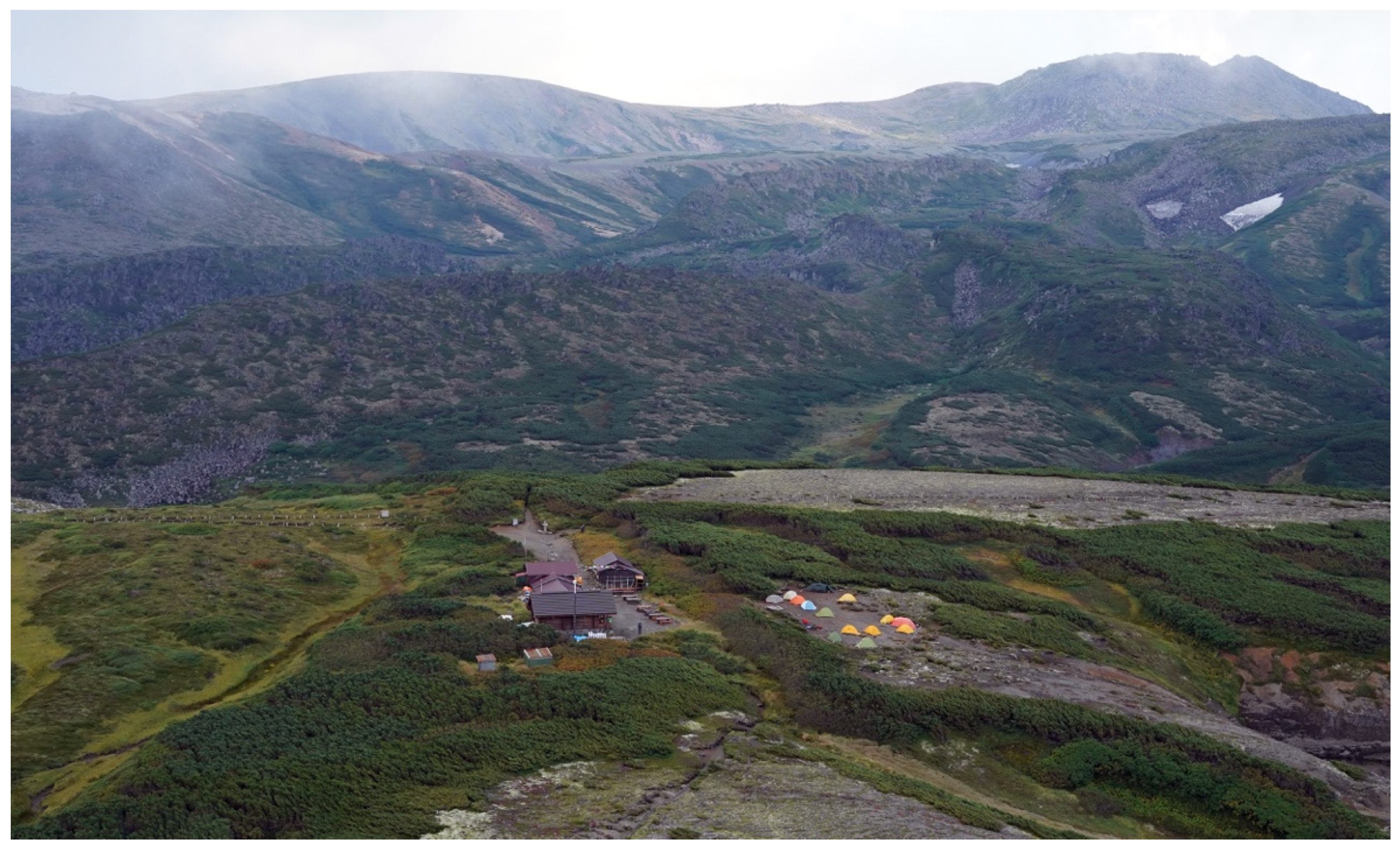
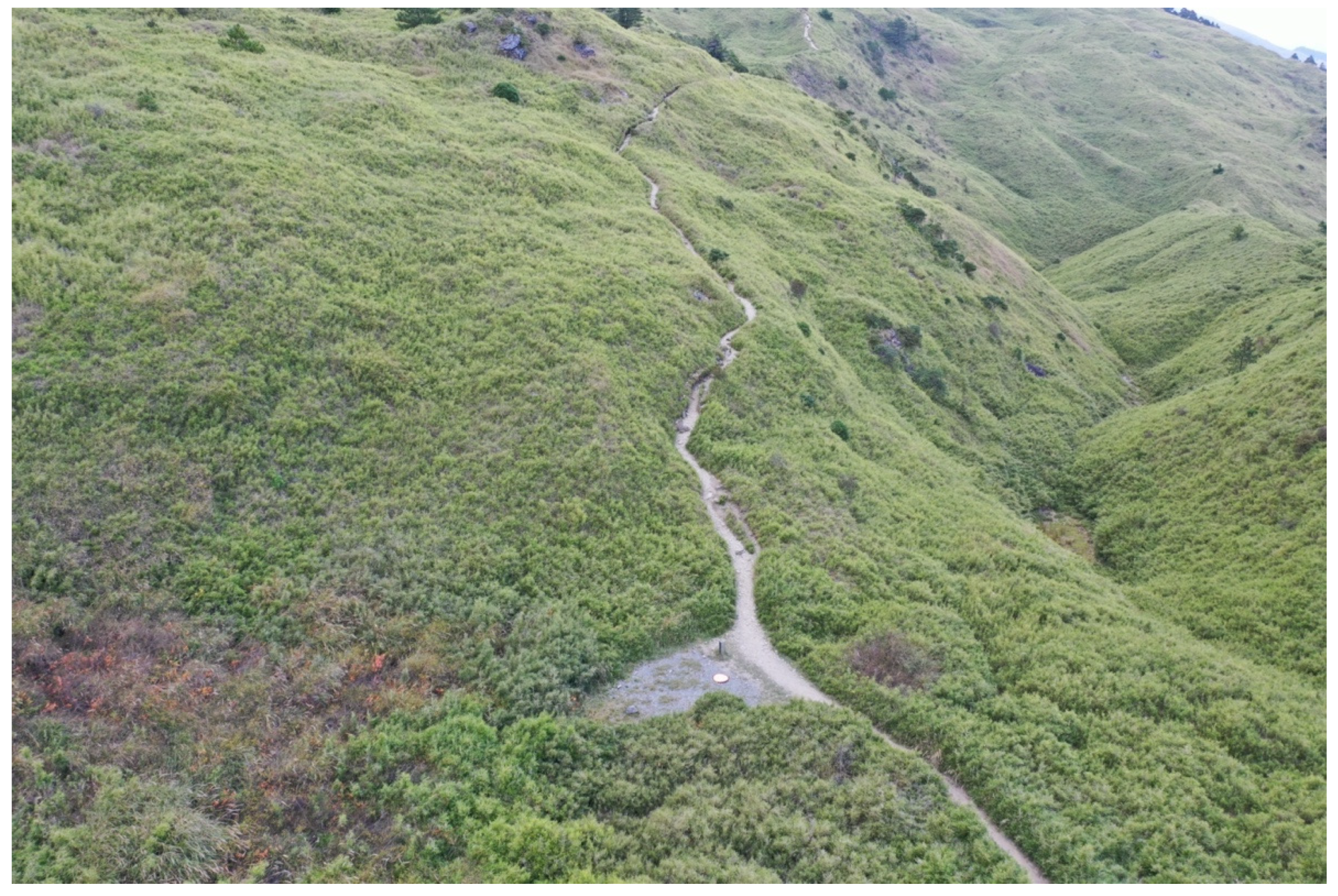
3.1.1. Distribution of Campsites

As shown in Table 1, most of the campsites in Daisetsuzan National Park are in the trail sections with the high “Daisetsuzan Grade” [39,40,41]. Five of the 12 campsites were at the trail sections with the highest grade (Grade = 5). The Kuro-dake campsite is located at the border between Grades 2 and 3, which is the lowest among the 12 campsites. It can be considered that the campsites’ layout is designed to be used by experienced and physically strong trekkers, except for the Kuro-dake campsite.
The average distance between adjacent campsites (two of which are attached to accommodation huts) is 7.3 km for the 12 campsites in Daisetsuzan National Park (Figure 1). They have a minimum distance of 2.5 km (Nanagome Trailhead–Kuro-dake campsite) and a maximum distance of 13.8 km (Tenninkyo Onsen–Hisago-numa campsite). The Futago-ike campsite (⑦ in Figure 1) is the only campsite between the Sansen-dai and Biei-Fuji campsite. Trekkers heading for Mt. Tomuraushi from Biei-Fuji Trailhead will have no accommodation facilities to use after they leave the Futago-ike campsite. The accommodation facilities will only be available again at the Minami-numa campsite (⑥ in Figure 1). The distance between the Futago-ike campsite and the Minami-numa campsite is 11.8 km (Table 1). One must walk 9 hours and 20 to 40 minutes (one way) without rest to reach the said campsite. Because of this, it is expected that some trekkers will be forced to camp along the trail. There are many informal camping spaces that campers have repeatedly used around the Sansen-dai junction (43°31′43″ N, 142°48′26″ E, 1760 m) in the west of Mt. Tomuraushi and the ridge between the Sansen-dai Junction and the Biei-Fuji campsite. The existence of such informal camping spaces indicates that the campsites are not properly arranged geographically in Daisetsuzan National Park’s entire alpine zone.

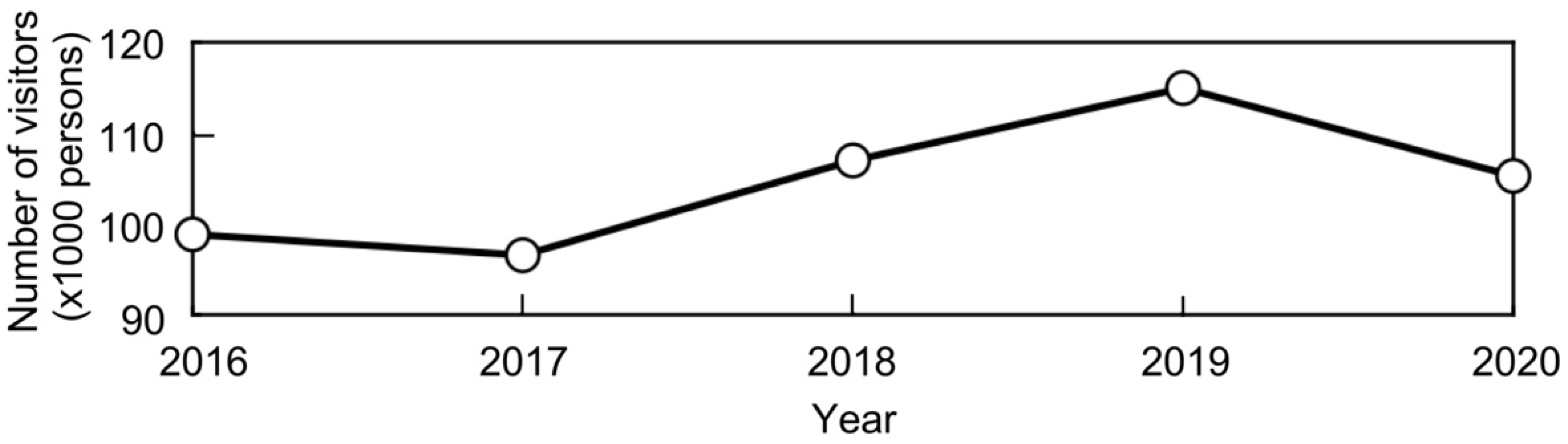
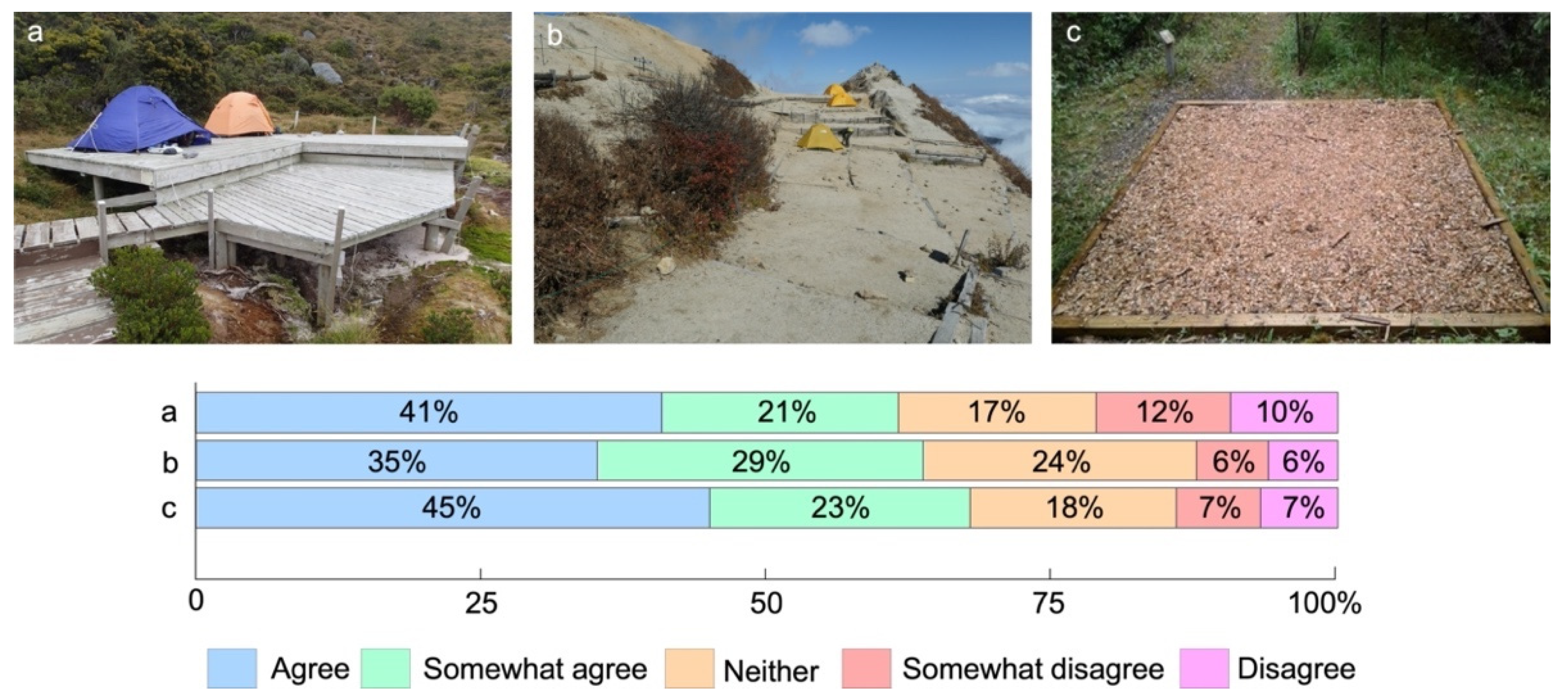
3.1.2. Questionnaire Survey with Campsite Users in Daisetsuzan National Park

In 2019 and 2021, we conducted a questionnaire survey with Daisetsuzan National Park’s users as respondents. We asked their opinion on the installation of platforms and tent pads and used photographs of existing campgrounds elsewhere (Figure 7). As a result, 62% of the respondents agreed or somewhat agreed to the installation of the platforms (a), and 64–68% agreed or somewhat agreed to the installation of the tent pads (b–c).

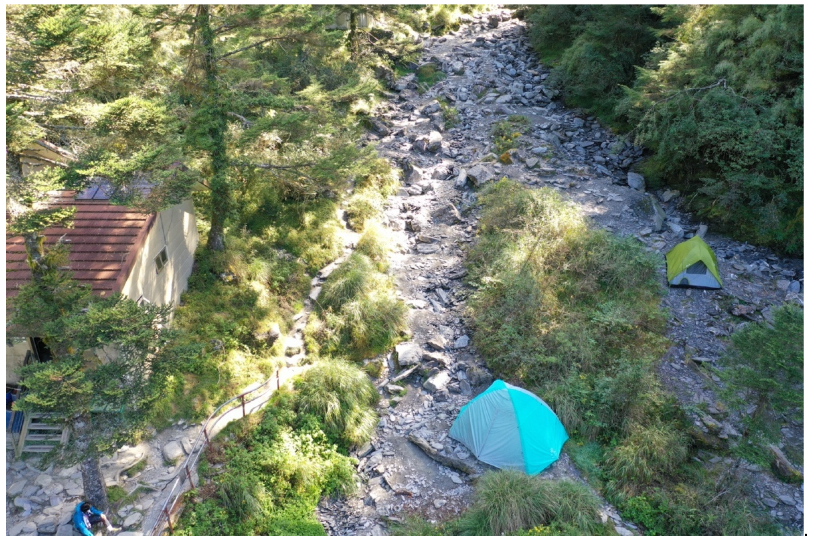
3.2. Campground Management in Taiwan

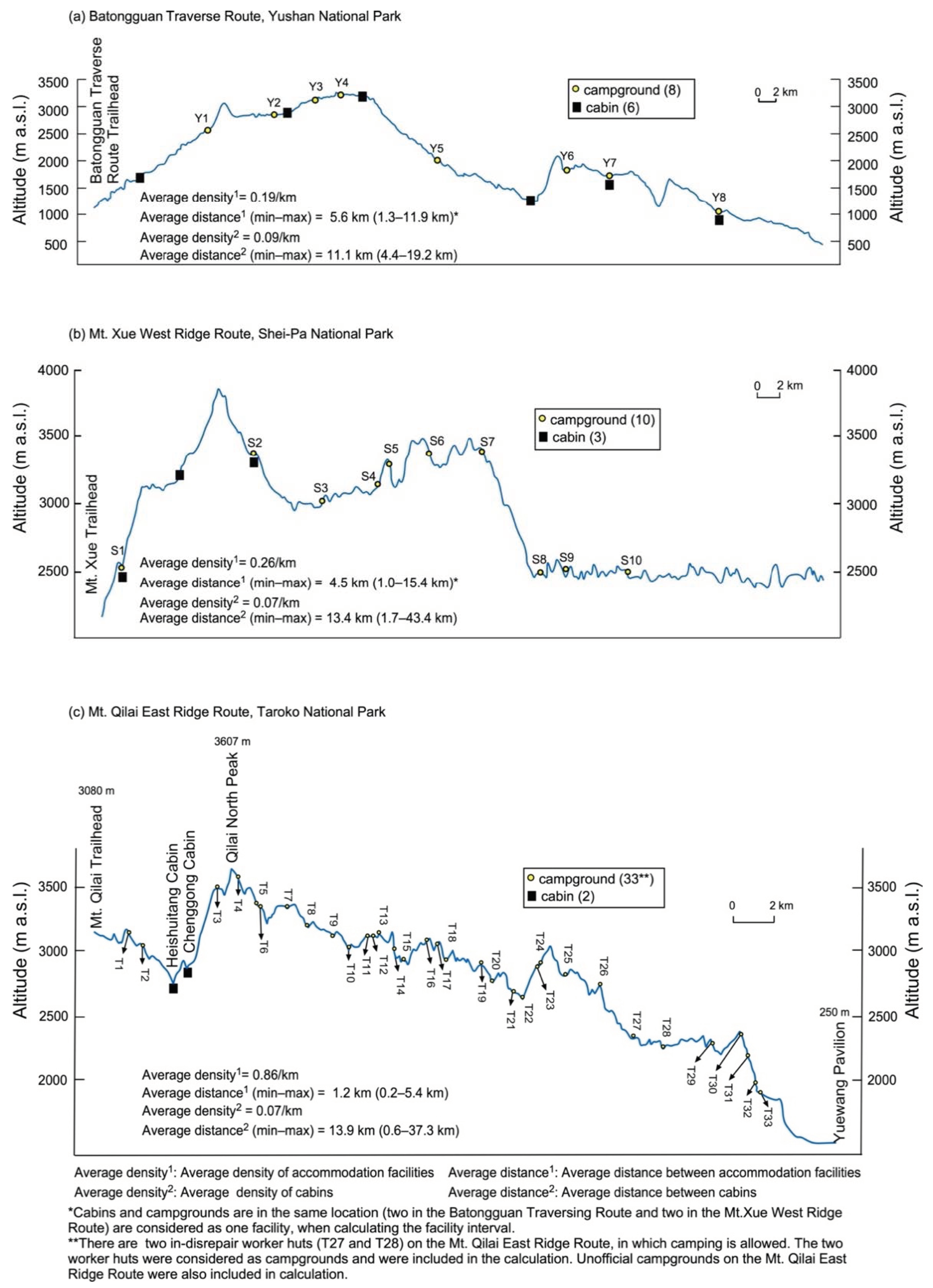
3.2.1. Distribution of Campgrounds

Among the three mountain national parks, Taroko National Park, which has the least number of cabins, had the largest number of campgrounds in the alpine zone. Conversely, Yushan National Park, which has the greatest number of cabins, had the fewest campgrounds (Table 2). It was also found that the number of cabins tended to be low along the trail sections with densely distributed campgrounds (Figure 4a–c). We calculated the average density of accommodation facilities (campgrounds and cabins) along the selected trail sections as the number of accommodation facilities per kilometer of trail length (Figure 8). Additionally, cabins’ average density was calculated in the same way as accommodation facilities’ average density to understand the influence of the absence of campgrounds on the accommodation of trekkers.
In contrast to the two other sections, the Yushan National Park’s Batongguan Traverse Route, where the smallest number of campgrounds were located, is dotted with cabins far from the trailhead (Figure 4a). The average density of the accommodation facilities at the Batongguan Traverse Route was the smallest (0.19 facilities/km). Conversely, the average interval distance between two adjacent accommodation facilities was the longest (approximately 5.6 km), with the longest interval distance being 11.9 km (Figure 8a). On the other hand, the Mt. Qilai East Ridge Route in Taroko National Park (Figure 8c) had accommodation facilities with the highest average density (0.86 facilities/km). Particularly, they have an average interval distance of 1.2 km (the shortest distance was 0.2 km) (Figure 8c). However, there are informal campgrounds at the Mt. Qilai East Ridge Route. As described below, we included these informal campgrounds in our calculations.
The cabins’ average density was almost the same in the three national parks (0.07–0.09 cabins/km). Specifically, the average interval distance between cabins was 11.1–13.9 km (Figure 8). The longest interval distance of the cabins on each trail section was 19.2 km (Batongguan Traverse Route) to 43.2 km (Mt. Xue West Ridge Route). The distance that trekkers would have to walk in a day would become significantly longer if campgrounds were not established. It likewise follows that a safe overnight trekking environment would not be secured. Therefore, the establishment of campgrounds is essential along the sections of the studied trails in all three national parks.

3.2.2. Online Reservation System and Management of Campgrounds in the Three National Parks

Limit on the Number of Campers

Reservations are required to use campgrounds in the three national parks that were surveyed. Users apply for park or mountain entry permits and reserve campgrounds through an entry permit application system (http://npm.cpami.gov.tw; accessed on 28 October 2021) of the three national parks. These had functioned independently before but were unified into one common system in November 2015. There are some differences among the parks in how they limit the number of users and how they implement campground reservations.
In Yushan National Park, the limitation on the number of campers in each campground is decided based on each campground’s capacity. This is determined by its area. The permitted number of campers in each campground ranged from four to 28.
In October 2019, Shei-Pa National Park changed its method of determining the use limitations for campgrounds. Before September 2019, the use limitation was determined based on the acceptable number of “sites” that could accommodate a four-person tent. A group of four or fewer people was counted as one “site” and a group of five to eight people was counted as two “sites” at that time. For example, the Qika campground (S1 in Figure 8b) had seven “sites,” which allowed a maximum of 28 people (seven groups) to camp. A total of 14 people were going to camp there if there were only two campers in each group. Thus, the number of people allowed for camping was highly dependent on reserved group’s size. After October 2019, Shei-Pa National Park adopted the same method as the Yushan National Park. The permitted number of campers in each campground ranges from eight to 40.
The capacity of each campground and the number of visitors allowed to use the area per day (the sum of the number of day-use visitors and the number of overnight visitors) is determined for each trail section in Taroko National Park. The arrangement of cabins and campgrounds and the limitations of their use are controlled according to each trail section’s capacity. Since the Qilai South Peak Route and the Zhuilu Old Road Route are day-use sections, no campgrounds are set up. Thus, number of people allowed to enter these trail sections is the largest (Table 3).
Cabins are the main accommodation facilities (Table 3) in the Qilai Main/North Peaks Route and the Mt. Qilai Range Route (the overlapped section with the western part of the Mt. Qilai East Ridge Route as shown in Figure 9a). However, the maximum number of people allowed to enter the trail section per day was larger than cabins’ capacity. The Qilai Main/North Peaks Route (Section A in Table 3 and Figure 9a) and the Mt. Qilai Range Route (Section B in Table 3 and Figure 9a) partially overlap. Similarly, this overlapped section also overlaps a part of the Mt. Qilai East Ridge Route described below. There are only three cabins set up in the A + B + C and A+B overlapped sections (Table 3 and Figure 9a). A maximum of 96 people per day are allowed to enter the overlapped section during holidays. The trekkers will either stay in one of the three cabins (Heishuitang, Chenggong, and Qilai) or camp in the open spaces around the cabins since this section is used by trekkers who will be staying overnight.
On the other hand, informal campgrounds that cannot be reserved also exist in the trail sections where campgrounds are the main accommodation facilities. For example, 13 campgrounds can be reserved online (two in-disrepair worker huts can be reserved for camping inside, so they are treated as campgrounds here) and 20 informal campgrounds cannot be reserved online on the Mt. Qilai East Ridge Route (Figure 8c). Four (T5, T20, T27, and T28) campgrounds among the 13 reservable campgrounds did not have an exact limit on the number of campers. On the other hand, eight of the 20 informal campgrounds that cannot be reserved online (e.g., T6 and T10) have a recommended maximum number of campers allowed for use. Such a number is simply judged based on the campground’s area. Among the 17 campgrounds where the limit on the number of campers is set, the smallest ones can only accommodate two people (n = 3; T17, T22, T23). In contrast, the other campgrounds can accommodate 32 people (n = 4; T7–T9, T24). Eleven campgrounds have a capacity of no more than six people. Generally, they set up individual campgrounds in a small size while increasing the distribution density to meet users’ accommodation needs.
The maximum number of reservations is often reached on weekends in all three national parks. Therefore, camping permit applications on weekends are often denied. For example, the number of applicants entering the ecological-protected area in Taroko National Park was 95,234 in 2016 and 188,353 in 2020 (Table 4). Around 4842–14,253 (average of 10,585) applications were rejected each year and were not allowed to enter the park (Table 4). The number of people applying for campground permits is linked to the number of applicants, even though the rejected applicants include day-use trekkers. This suggests that a certain number of people are unable to obtain permits to enter the camp on weekends. When we visited the Chenggong cabin on 12–13 October 2019 (a weekend), around 10 tents were pitched by trekkers who could not reserve a bed inside (Figure 10).

3.2.3. National-Park Managers’ Approach to Campground Management and Reservation System

In Taiwan, each national park has its own National Park Headquarters which is directly responsible for the operation and management of the park. This is pursuant to Article 5 of the National Park Act. The National Park Headquarters is under the Construction and Planning Agency. Moreover, the National Park Division is affiliated with the Ministry of the Interior of Taiwan (equivalent to the Ministry of the Interior in other countries), which has jurisdiction over national parks.
Each national park headquarters has its own “Recreation and Service Section” and “National Park Police Division.” Private companies donate a portion of the necessary funds to support the maintenance of trails and campgrounds. At the time of the interview, only Shei-Pa National Park received donations from private companies. Under the National Park Act, the park police division will fine unauthorized visitors the amount of 3000 NTD (about 110 USD) per person. The average number of people who were fined for unauthorized entry was seven to eight per year according to the interviews with the park administrators.
The reservation-based management system for campgrounds was positively perceived by all the managers of the three parks. After introducing the reservation system, the parks succeeded in eliminating the crowding problem and improving the camping experience for users on popular campgrounds such as the Qika campground (S1 in Figure 8b) in Shei-Pa National Park. However, according to the managers of Shei-Pa National Park, unauthorized campers sometimes appear at some campground (e.g., Yopolan campground) on holidays and other days when there are many visitors. This causes crowding problems as the number of users exceeds the limit set per day. In the Taroko National Park, the informal campgrounds around the three cabins on the Qilai Main/North Peaks Route (Figure 9) are often crowded. This likewise causes crowding problems four to five times a year. It is difficult to build new cabins in the alpine zone, and these informal campgrounds are considered essential on crowded days when the number of users exceeds the cabins’ capacity.
According to the interviews, managers of the three national parks consistently recognized that “the current campgrounds are well-balanced based on the walking distance. Moreover, the number of users is limited, so we have no plans to build more campgrounds”. However, in Mt. Xue West Ridge Route in Shei-Pa National Park, no campgrounds exist in the last 15.4 km section (Figure 8). The walking distance in this area is more than three times the average. This actual situation was quite different from their words, as shown in Figure 8.
Some trekkers complain about the current reservation system for campgrounds. They say that “the reservation system is too strict to get any freedom.” However, park managers believe that use limitations and reservation systems are essential to maintain sustainable park management with limited resources. There are many informal campgrounds along the Mt. Qilai East Ridge Route in Taroko National Park (Figure 8c and Figure 11). These informal campgrounds are not shown on the Taroko National Park Trail Map (1:60,000), the Hengdian and Mt. Qilai Range map, and the Mt. Qilai East Ridge Route map (both 1:25,000). However, they can be used in cases of emergency.

4. Discussion

4.1. The Reservation System of Campgrounds in Taiwan’s National Parks

The reservation-based campgrounds in the three mountain national parks in Taiwan are small. These campgrounds only have an available camping space for 2–40 people. One of the main characteristics of these campgrounds is that they are either inserted between cabins or set up close to each other. This is done to reduce the distance between accommodation facilities (Figure 8). Thus, the area of the individual campgrounds can be reduced by adopting this method. As a result, the campgrounds’ management becomes easier, and the expansion of the bare ground on each campground is minimized. The interval between small campgrounds is small (less than 1 km around 19 campgrounds) especially in the Mt. Qilai East Ridge Route, as shown in Figure 8c. The crowding problem in the campgrounds was reduced and the quality of the camping experience was improved because of the reservation system. These changes were recognized by the interviewed national park managers.
However, the crowding problem in the campgrounds has not been eliminated. Since 2019, Shei-Pa National Park has improved the spatial distribution of the number of users in the campgrounds by clarifying the maximum number of people allowed to stay in each campground per day. Nevertheless, the managers acknowledge that crowding problems have arisen in some campgrounds due to the entrance of unauthorized campers during holidays. This indicates that it is necessary to reexamine the number of accommodations to match the number of users during crowded periods (e.g., holidays and weekends). However, it is important to monitor the specific camping situation of the campgrounds on crowded days as well.
The maximum number of people allowed to enter the Taroko National Park per day was set for each trail section. Additionally, there is “lenient management” with three types of restrictions: (a) setting the maximum number of people allowed to stay per day for each campground; (b) indicating the recommended number of users; (c) or setting no limit at all. This type of entry quota by the trailhead allows visitors to freely change their itineraries in response to the weather conditions. This is also important for trekking especially in severe mountain environments [42].
The Mt. Qilai East Ridge Route (Mt. Qilai Trailhead, Qilai North Peak, Yuewang Pavilion) is a 41.8-km long trail section with a 6- to 7-day itinerary. This is true especially for the section from the Mt. Qilai Trailhead to the Main/North Peaks Junction (overlapped Section A + B + C in Figure 9). It is a common section for the Qilai Main/North Peaks Route (A), Mt. Qilai Range Route (B), and Mt. Qilai East Ridge Route (C). Therefore, it has an extremely large number of users. The length of the route from the Mt. Qilai Trailhead to Qilai North Peak is 15.4 km round trip (about 12 h without rest). Conversely, the length of the route from the Mt. Qilai Trailhead to Mt. Qilai is 20.2 km round trip (approximately 14 h without rest). Few people trek through these sections in one day. In other words, most people using the A + B + C overlapped section from the Mt. Qilai Trailhead to the Main/North Peak Junction will stay overnight. If the number of people allowed to enter this trail section on weekends reaches the limit, 36 people will not be allowed to stay in the cabin and they must camp outside. There is a small space around the Heishuitang cabin and Qilai cabin where several tents can be pitched (Figure 9b). There is likewise some space available around the Chenggong cabin. However, campers will need to pitch their tents on the riverbank when it is crowded (Figure 10). The closest campground (T5 in Figure 8c) to the trailhead of the Mt. Qilai East Ridge Route is located 9.2 km away (requiring about 8 h of travel, one way, without rest). There is no limitation on the number of campers for this campground because park managers can just inform applicants about the reservation availability based on their judgment.
According to interviews with park managers, cabins are always fully reserved during holidays and weekends. Moreover, many people camp around the cabins. Nevertheless, they still believe that there is no immediate need to increase the number of campgrounds. The average number of people who could not get a reservation for entry reached 10,585 in recent years (Table 4). Additionally, seven to eight unauthorized visitors are found in each park every year. It is estimated that the actual number of unauthorized visitors is higher than the number of visitors who are fined. Thus, it can be said that Taroko National Park manages its campgrounds by introducing a lenient reservation system. Particularly, they combine campgrounds that can be reserved online with informal campgrounds that cannot be reserved. This type of management is similar to the backcountry overnight permit system in some national parks in the USA (e.g., Glacier National Park, Olympic National Park, and Zion National Park). In these parks, they combine the reservation of specific campgrounds and the reservation of designated camping zones with limitations on use.

4.2. Application of a Reservation System to the Campsites in Daisetsuzan National Park

Unlike Taiwan’s three mountain national parks, no reservation system has been introduced for campsites in Daisetsuzan National Park’s alpine zone. Therefore, users pitch their tents in any available space upon arrival. As a result, tents are often pitched in front of the hut or on the trail when the campsite is crowded. This deteriorates the quality of the nature experience, caused by the crowding and soil erosion on the campsites [14]. We will now discuss two approaches to address these issues in the following sub-sections: (1) the introduction of a reservation-based management for campsites in Daisetsuzan National Park’s alpine zone; and (2) the introduction of active management through the installation of platforms and tent pads as used in North America, taking the Kuro-dake campsite as an example.

4.2.1. Introduction of a Reservation System to the 12 Campsites

The campsite intervals in Daisetsuzan National Park (average = 7.3 km, range = 2.5–13.8 km) are larger than those along the Batongguan Traverse Route in Yushan National Park (average = 5.6 km, range = 1.3 km–12.9 km). The latter has the largest intervals among the three studied trails in Taiwan’s national parks. As stated earlier, it is expected that some trekkers will be forced to camp on or along the trail because of the inadequate distances between the two nearest campsites and between a campsite and a trailhead (⑥ and ⑦ in Figure 1; Table 1). Therefore, it is necessary to review the spatial layout of campsites to ensure the safety of the trekkers. According to the “Management Plan for Daisetsuzan National Park” [43], “campsites in Daisetsuzan National Park should be reviewed by related organizations, taking into consideration the impact on the surrounding ecosystem and the use of the site by trekkers. If necessary, deletions, additions, or location changes will be considered based on the opinions of local mountain associations and park users”. Therefore, it is feasible to review the spatial arrangement of the 12 campsites in Daisetsuzan National Park. However, such a review has not been conducted so far.
It is also necessary to discuss whether the reservation system should be introduced to all campsites. For example, in the Ura-Asahi campsite of Daisetsuzan National Park, the level of use is too low to cause any crowding problem even on weekends and holidays (unpublished data by the authors). It seems that using the reservation system to ration bookings is not necessary here. However, some trekkers may demand that camping be allowed anywhere in the alpine zone of Daisetsuzan National Park if campsites where tents are overflowing are left unmanaged. This is because these trekkers have seen overflowed tents around the Kuro-dake campsite. Therefore, the introduction of a reservation system for all campsites, including those that are not crowded, will help enforce the rule that camping outside of campsites will not be tolerated. However, it is unrealistic to have a permanent manager stationed at all 12 campsites. The campsites are dispersed over a wide area. It would be more appropriate to introduce a “lenient management” system, combining campsites that require reservations and those that do not, because it is extremely difficult to confirm reservations without a manager (e.g., Taroko National Park).
In the case of Daisetsuzan National Park, introducing a reservation system mainly for campsites where tents are likely to overflow on crowded days can be a good option. No managers were stationed at the sites in Daisetsuzan National Park. The presence of a permanent manager is not essential for the introduction of a reservation system. In other words, it is possible to introduce a reservation system even when there are no permanent managers at the site. In this way, the introduction of “lenient management’ can reduce the crowding problem, improve the quality of users’ camping experience, and reduce the burden on managers.
As for the maintenance and management of the campsites, it should be carried out as necessary, just like mountain trails. Ropes should be set up around the campsites to prevent the expansion of bare ground in campsites without a permanent manager. Meanwhile, a reservation system should be adopted to grant permits to the number of people who can be accommodated within the ropes. Daisetsuzan National Park has incorporated the power of volunteers, private organizations, and researchers into the maintenance of the trails [40,44,45]. Combining the campsites’ management and maintenance with this existing collaborative trial maintenance work will increase the feasibility of such a fieldwork on campsites. Recent studies have emphasized the importance of involving local communities in the management of national parks or other protected areas [46,47,48]. Their involvement will most likely reduce the burden on park managers and promote sustainable management [49,50].

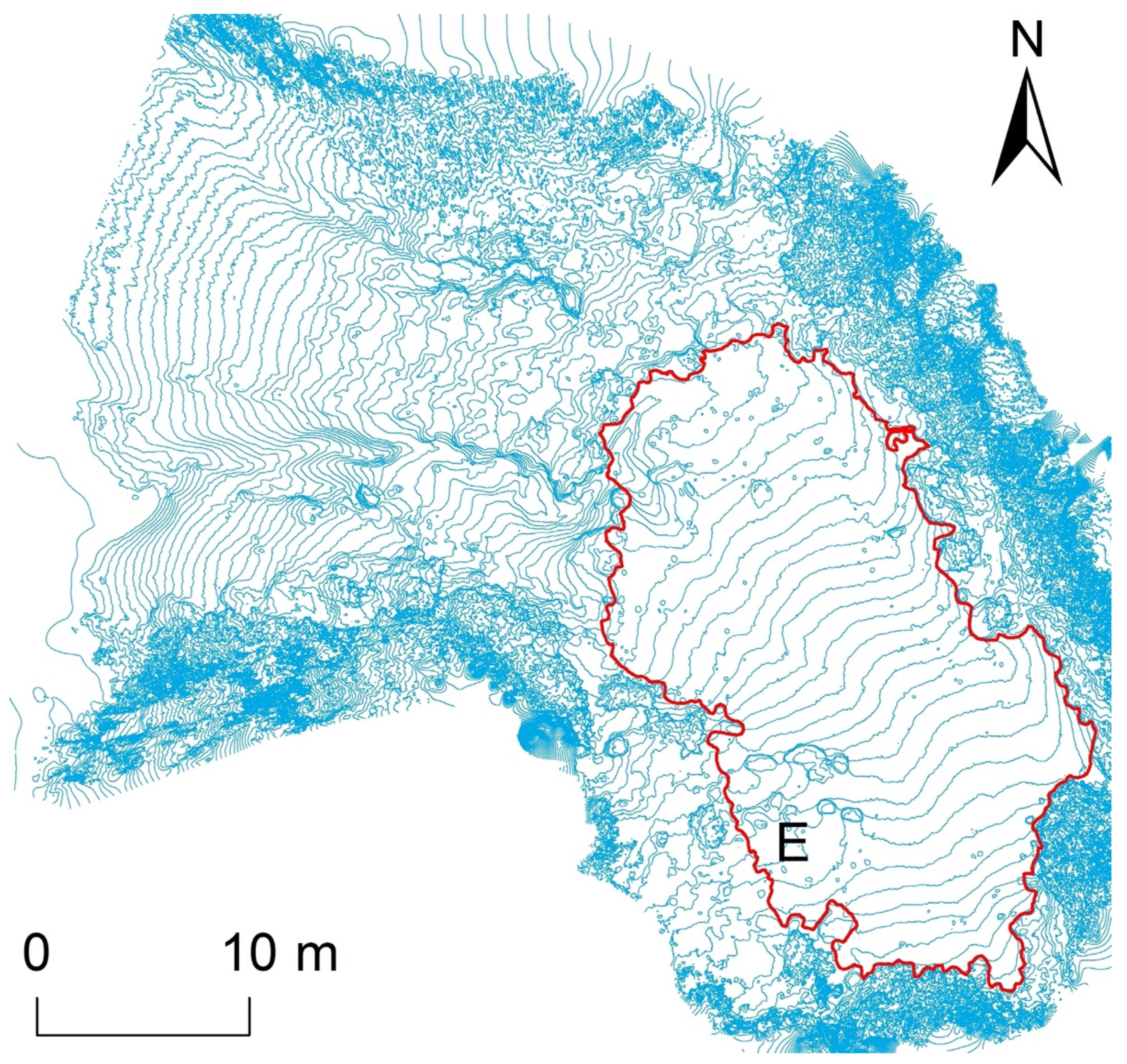
4.2.2. Application to the Kuro-Dake Campsite

In this sub-section, we will discuss the introduction of active management into the Kuro-dake campsite. This campsite is closest to the trailhead, with a high proportion of novice users and overuse problems [14].
In general, it is considered better to set up campgrounds in flat areas to prevent soil erosion. However, it is not always considered a good idea in the recreation ecology field. For example, a study pointed out that campgrounds should be located in places without large flat areas to control impacts of camping (e.g., vegetation loss and bare ground expansion) within acceptable levels [13]. This is because campgrounds are more easily expanded spatially on a flat surface to increase the area of impact. In the Kuro-dake campsite, we found that the area had expanded from 346 m2 in 2012 to 394 m2 in 2017, mainly on the southwest side (E in Figure 12). This is true despite ropes being set up around the site [14].
As mentioned earlier, tents still overflowed from the Kuro-dake campsite during crowded periods even after site expansion. This is because the Kuro-dake campsite is too small considering its use level. Our previous study identified that tent overflow occurs repeatedly on certain weekends and holidays around the same dates every year [14]. In this regard, it is suggested that the reservation system can be introduced only on crowded days. A group discussion with 11 stakeholders of the park regarding introducing a reservation system to the Kuro-dake campsite was conducted on 5 March 2021. The results showed that 82% of the participants agreed to introduce a reservation system to the Kuro-dake campsite. Compared to the full-season campsite reservation system, more participants (55%) preferred a reservation system only on crowded days. One stakeholder mentioned that it was easy to introduce a reservation system to the Kuro-dake campsite with the help of the manager of the Ishimuro hut–Rinyukanko Company because the company can provide necessary infrastructure such as an official website to handle the users’ reservations. The main obstacle is that there is currently no formal manager for the campsite, so the introduction of an immediate reservation system cannot be realized. Our previous study also found that most users of the Kuro-dake campsite showed positive opinions on introducing the reservation system [14]. Another study found that users are usually more pleased with reservations compared to other rationing methods [51]. The Daisetsuzan National Park Management Office of the Ministry of the Environment should take leadership to manage the reservation system.
A previous study suggested that reducing use levels by rationing methods such as reservations should only be considered when less restrictive measures are ineffective [32]. In the 2021 camping season, a calendar indicating the predicted congestion level of the Kuro-dake campsite was posted on the homepage of Daisetsuzan National Park Council. The council is the trail management’s core organization based on the partnership program with stakeholders, aiming to disperse use to uncrowded days. However, the procedure was unsuccessful. On the final day of the camping season (Sunday, 19 September 2021) when the congestion level was not shown, a total of 46 tents were pitched in the Kuro-dake campsite with 13 tents overflowing to the nearby trail. The reason for this failure may be that the congestion level was not provided. Thus, users expected a less crowded condition that day. However, congestion on a few popular weekends could not be avoided even if the crowding information was fully provided. Another study found that visitors who cannot easily shift their schedule for the visit will still go as planned, even if they know that the day may be very crowded [52]. Therefore, a reservation system with a specific limitation on the number of users, instead of any indirect management action, should be considered for the Kuro-dake campsite.
In addition, management actions need to be considered to avoid the waste of reservations when reserved users do not show up, like in Denali National Park [24]. For example, in Rocky Mountain National Park in the USA, backcountry campers must pick their camping permits before noon of their entry date. People who do not show up without a valid reason will be fined a $36 Wilderness Administrative Fee. The unused permits will then be distributed to other applicants on a waiting list. In the three surveyed national parks in Taiwan, users who are unable to come as planned must cancel their reservations before a preestablished deadline (Yushan National Park: seven days before entry date; Shei-Pa National Park: five days before entry date; and Taroko National Park: one day before entry date). If not, they will be denied entry for the following six months (see Table A1). Discussions regarding these regulations are also necessary when introducing a reservation system to the Kuro-dake campsite.
The installation of platforms and tent pads provides an advantage insofar as the maximum number of tents per day at a given site can be determined. This enables the easy introduction of a reservation system based on the maximum number of tents that can be reserved. Many users in Daisetsuzan National Park are positive about the introduction of platforms or tent pads (Figure 7). Therefore, it is time to consider their installation and the introduction of a reservation system. As shown in Figure 12, the entire Kuro-dake campsite is gently sloping. To reduce soil erosion, active management (e.g., establishment of platforms/tent pads on sloping terrain) is required [16,19,53]. It is important to discuss the possibility of introducing tent pads by flattening the ground surface into a terraced field for tent sites, as in the case of the Enzanso campground in Chubusangaku National Park (Figure 7b). In addition to introducing platforms or tent pads, expanding the site to the campsite’s southwest or northwest portion would also be another option to consider.

5. Conclusions

This study investigated the reservation systems of campgrounds in three mountain national parks in Taiwan. It was found that the spatial arrangement of campgrounds with online reservation and informal campgrounds with no reservation system in place was successful in reducing the distance between adjacent campgrounds and the area of the individual site. National-park managers recognized that the introduction of reservation-based campground management would be effective in reducing crowding problems and improving camping experience. However, it was also found that there is still room for improvement. Particularly, there is still a crowding problem caused by unauthorized camping in some campgrounds that needs to be addressed.
In Japan’s mountain national parks, using existing trails, campgrounds, and campsites as they are to be normally used and making minimum changes as possible has been recognized as “protecting nature” (or at least “not artificially modifying nature”). Since the establishment of the Ministry of the Environment in 2001, active and collaborative management’s importance with local communities has increased in Japan’s mountain national parks [54]. Although the maintenance and management of the trails in Daisetsuzan National Park are still in the middle of their way, significant progress has been made with the cooperation of local stakeholders. However, crowding and soil erosion on campsites have been neglected. Against this backdrop, the goal of confirming the quality of the camping experience, which is important for managing national parks, has not been fulfilled. The time has come to discuss changing the unmanaged conditions of campsites in Daisetsuzan National Park. The comprehensive analysis of the successful application of reservation-based campground management in Taiwan can provide specific directions for improving the current camping environment in Daisetsuzan National Park.
The introduction of a lenient reservation system that combines campsites requiring an online reservation and those that do not, as in the case of Taroko National Park, is another option that should be immediately discussed. Considering the current situation where soil erosion, bare ground expansion, and overflowing tents have occurred in the campsites, it is important to introduce active management. This must be done before the complete deterioration of both the environment and the camping experience’s quality. Specifically, it is suggested that discussions should be held on active management. This includes reviewing campsites’ spatial layouts and installing platforms or tent pads to campsites with a high number of users and significant soil erosion (e.g., Kuro-dake campsite). Due to the similar environment and similar management goals of mountainous national parks, the examples of the three Taiwan’s national parks can be used as a reference for Daisetsuzan National Park.

Author Contributions

Conceptualization and methodology, T.W. (Ting Wang) and T.W. (Teiji Watanabe); Software, T.W. (Ting Wang); Investigation, T.W. (Ting Wang) and T.W. (Teiji Watanabe); Writing—Original Draft Preparation, T.W. (Ting Wang); Writing—Review and Editing, T.W. (Teiji Watanabe); Visualization, T.W. (Ting Wang) and T.W. (Teiji Watanabe); Supervision, T.W. (Teiji Watanabe). All authors have read and agreed to the published version of the manuscript.

Funding

This research received no external funding.

Institutional Review Board Statement

Not applicable.

Data Availability Statement

Not applicable.

Acknowledgments

We would like to express our gratitude to Po-Wen Shih and Chia-Hung Sun of Yushan National Park; Ching-Chang Hu, and Chen-Yeh Wu of Shei-Pa National Park; and Shih-Chao Nieh, Hung-Yu Yen, Shu-Pao Chen, Chi-Kai Yin and Hao-Hsuan Huang of Taroko National Park for providing the information of campgrounds. We would also like to extend our special thanks to Taroko National Park and Daisetsuzan National Park for granting us the permission to fly a UAV (drone) above their parks. Moreover, we would like to express our gratitude to Kousei Masu, Akane Saito, and other staff members of the Daisetsuzan National Park Management Office of the Ministry of the Environment (formerly Kamikawa Park Ranger Office) and Higashikawa Management Office (formerly Higashikawa Park Ranger Office) for always making themselves available for discussions. Lastly, we would like to thank Yusuke Kobayashi of Hokkaido University for his assistance with our field survey.

Conflicts of Interest

The authors declare no conflict of interest.

Appendix A

Table A1. The number of suspended visitors due to “no show” and unauthorized entry in three national parks in Taiwan in 2021.
NameNumber of Applicants (Persons) *Number of Permissions (Persons) *Suspended Due to “No Show” (Persons) **Suspended Due to Unauthorized Entry (Persons) **
Yushan National Park152,42460,0666329
Taroko National Park190,57284,343372 ***4
Shei-Pa National ParkNA68,292515
* These are compiled from the data on the home pages of the three national parks. ** These data are compiled from the homepage of “Online Application for Admission to Taiwan’s National Parks” (available since 2021). *** Visitors who did not follow the itinerary as permitted were included.

References

  1. Hammitt, W.E.; Cole, D.N. Wildland Recreation: Ecology and Management, 2nd ed.; John Wiley & Sons, Ltd.: New York, NY, USA, 1998. [Google Scholar]
  2. Cole, D.N. Changing Conditions on Wilderness Campsites: Seven Case Studies of Trends over 13 to 32 Years; RMRS-GTR-300; USDA, Forest Service, Rocky Mountain Research Station: Fort Collins, CO, USA, 2013. [Google Scholar]
  3. Cole, D.N.; Monz, C.A. Spatial patterns of recreation impact on experimental campsites. J. Environ. Manag. 2004, 70, 73–84. [Google Scholar] [CrossRef] [PubMed] [Green Version]
  4. Growcock, A.J.W. Impacts of Camping and Trampling on Australian Alpine and Subalpine Vegetation and Soils. Ph.D. Thesis, Griffith University, Southport, QLD, Australia, 2005. [Google Scholar] [CrossRef]
  5. Marion, J.L. A review and synthesis of recreation ecology research supporting carrying capacity and visitor use management decisionmaking. J. For. 2016, 114, 339–351. [Google Scholar] [CrossRef]
  6. Cole, D.N.; Foti, P.; Brown, M. Twenty years of change on campsites in the backcountry of Grand Canyon National Park. Environ. Manag. 2008, 41, 959–970. Available online: https://www.fs.fed.us/rm/pubs_other/rmrs_2008_cole_d001.pdf (accessed on 10 January 2022). [CrossRef] [PubMed] [Green Version]
  7. Dixon, G.; Hawes, M. A longitudinal multi-method study of recreational impacts in the Arthur Range, Tasmania, Australia. J. Outdoor Recreat. Tour. 2015, 9, 64–76. [Google Scholar] [CrossRef]
  8. Cole, D.N. Campsites in Three Western Wildernesses: Proliferation and Changes in Condition Over 12 to 16 Years; INT-463; USDA, Forest Service, Intermountain Research Station: Ogden, UT, USA, 1993. [Google Scholar]
  9. Hammitt, W.E.; Cole, D.N.; Monz, C.A. Wildland Recreation: Ecology and Management, 3rd ed.; John Wiley & Sons, Ltd.: New York, NY, USA, 2015. [Google Scholar]
  10. Smith, A.J.; Newsome, D. An integrated approach to assessing, managing and monitoring campsite impacts in Warren National Park, western Australia. J. Sustain. Tour. 2002, 10, 343–359. [Google Scholar] [CrossRef]
  11. D’Antonio, A.; Monz, C.; Newman, P.; Lawson, S.; Taff, D. Enhancing the utility of visitor impact assessment in parks and protected areas: A combined social-ecological approach. J. Environ. Manag. 2013, 124, 72–81. [Google Scholar] [CrossRef]
  12. Aikoh, T.; Asakawa, S. The Influence of tent setting on visitors’ crowding perception at mountainous campsite. J. JILA 1998, 61, 627–630. [Google Scholar] [CrossRef]
  13. Daniels, M.L.; Marion, J.L. Visitor evaluations of management actions at a highly impacted Appalachian Trail camping area. Environ. Manag. 2006, 38, 1006–1019. [Google Scholar] [CrossRef]
  14. Wang, T.; Watanabe, T. Impact of recreational activities on an unmanaged alpine campsite: The case of Kuro-dake campsite, Daisetsuzan National Park, Japan. Environments 2019, 6, 34. [Google Scholar] [CrossRef] [Green Version]
  15. Mallikage, S.T.; Perera, P.; Newsome, D.; Bandara, R.; Simpson, G. Effects of recreational camping on the environmental values of national parks in Sri Lanka. Trop. Life Sci. Res. 2021, 32, 119–145. [Google Scholar] [CrossRef]
  16. Marion, J.L.; Farrell, T.A. Management practices that concentrate visitor activities: Camping impact management at Isle Royale National Park, USA. J. Environ. Manag. 2002, 66, 201–212. [Google Scholar] [CrossRef] [PubMed]
  17. Reid, S.E.; Marion, J.L. Effectiveness of a confinement strategy for reducing campsite impacts in Shenandoah National Park. Environ. Conserv. 2004, 31, 274–282. [Google Scholar] [CrossRef] [Green Version]
  18. Eagleston, H.; Marion, J.L. Sustainable campsite management in protected areas: A study of long-term ecological changes on campsites in the boundary waters canoe area wilderness, Minnesota, USA. J. Nat. Conserv. 2017, 37, 73–82. [Google Scholar] [CrossRef] [Green Version]
  19. Marion, J.; Arredondo, J.; Wimpey, J.; Meadema, F. Applying recreation ecology science to sustainably manage camping impacts: A classification of camping management strategies. Int. J. Wilderness 2018, 24, 84–100. Available online: https://www.fs.fed.us/rm/pubs_journals/2018/rmrs_2018_marion_j001.pdf (accessed on 10 January 2022).
  20. Leung, Y.F.; Marion, J.L. Characterizing backcountry camping impacts in Great Smoky Mountains National Park, USA. J. Environ. Manag. 1999, 57, 193–203. [Google Scholar] [CrossRef]
  21. Farrell, T.A.; Marion, J.L. Camping Impact Management at Isle Royale National Park: An Evaluation of Visitor Activity Containment Policies from the Perspective of Social Conditions. In Proceedings of the RMRS-P-15-VOL-5, Missoula, MT, USA, 23–27 May 1999; USDA, Forest Service, Rocky Mountain Research Station: Ogden, UT, USA, 2000; pp. 110–114. Available online: https://www.fs.fed.us/rm/pubs/rmrs_p015_5/rmrs_p015_5_110_114.pdf (accessed on 10 January 2022).
  22. Dixon, G. A longitudinal study of backcountry track and campsite conditions on the Overland Track, Tasmania, Australia. J. Outdoor Recreat. Tour. 2017, 19, 25–36. [Google Scholar] [CrossRef]
  23. Arredondo, J.R.; Marion, J.L.; Meadema, F.P.; Wimpey, J.F. Modeling areal measures of campsite impacts on the Appalachian National Scenic Trail to enhance ecological sustainability. J. Environ. Manag. 2021, 279, 111693. [Google Scholar] [CrossRef]
  24. Denver Service Center. Environmental Assessment for Development Concept Plan: Park Road Corridor, Denali National Park, Alaska; Denver Service Center, National Park Service, U.S. Department of the Interior: Denver, CO, USA, 1982; Available online: https://play.google.com/books/reader?id=pM5QAAAAYAAJ&pg=GBS.PP6&hl=ja (accessed on 14 January 2022).
  25. Walls, M.; Wichman, C.; Ankney, K. Nature-Based Recreation: Understanding Campsite Reservations in National Parks; Resources for the Future: Washington, DC, USA, 2018; Available online: https://media.rff.org/documents/CampsiteReservations_Report_Final.pdf (accessed on 14 January 2022).
  26. Wagar, J.A. The carrying capacity of wild lands for recreation. For. Sci. 1964, 10, 1–24. Available online: https://academic.oup.com/forestscience/article-abstract/10/suppl_2/a0001/4746150?redirectedFrom=fulltext (accessed on 14 January 2022).
  27. Abernethy, V.D. Carrying capacity: The tradition and policy implications of limits. Ethics Sci. Environ. Polit. 2001, 2001, 9–18. Available online: http://www.int-res.com/articles/esep/2001/article1.pdf (accessed on 14 January 2022). [CrossRef]
  28. Wang, H.-Y.; Liang, M.-P.; Huang, W.-T. Taroko National Park Assessment on Mountaineering Behavior Model and Environmental Carrying Capacity of the Nanhu Mountain Area; Taroko National Park Headquarters: Hualian, Taiwan, 2008. Available online: https://www.taroko.gov.tw/News_Content.aspx?n=5522&s=227087 (accessed on 14 February 2022).
  29. Lin, Y.-Z. Study on the Recreational Carrying Capacity of Hiking Trails in Yushan National Park; Yushan National Park Headquarters: Nantou, Taiwan, 2002. Available online: https://www.ysnp.gov.tw/AchievementReport/C004610?ID=DCE64924-E75E-4B5A-A280-EDE9E42DAD52&PageIndex=1&PageType=1 (accessed on 10 January 2022).
  30. Stankey, G.H.; Cole, D.N.; Lucas, R.C.; Petersen, M.E.; Frissell, S.S. The Limits of Acceptable Change (LAC) System for Wilderness Planning; INT-176; USDA, Forest Service, Intermountain Forest and Range Experiment Station: Ogden, UT, USA, 1985. Available online: https://www.fs.usda.gov/Internet/FSE_DOCUMENTS/stelprdb5346594.pdf (accessed on 22 December 2021).
  31. Diedrich, A.; Balaguer Huguet, P.; Tintoré Subirana, J. Methodology for applying the Limits of Acceptable Change process to the management of recreational boating in the Balearic Islands, Spain (Western Mediterranean). Ocean Coast. Manag. 2011, 54, 341–351. [Google Scholar] [CrossRef]
  32. Stankey, G.H.; Baden, J. Rationing Wilderness Use: Methods, Problems, and Guidelines; INT-192; USDA, Forest Service, Intermountain Forest and Range Experiment Station: Ogden, UT, USA, 1977. [Google Scholar] [CrossRef]
  33. Van Wagtendonk, J.W. The effect of use limits on backcountry visitation trends in Yosemite National Park. Leis. Sci. 1981, 4, 311–323. [Google Scholar] [CrossRef]
  34. Cupul-Magaña, A.L.; Rodríguez-Troncoso, A.P. Tourist carrying capacity at Islas Marietas National Park: An essential tool to protect the coral community. Appl. Geogr. 2017, 88, 15–23. [Google Scholar] [CrossRef]
  35. Manning, R.E. Research to guide management of outdoor recreation and tourism in parks and protected areas. Koedoe 2014, 56, 1–7. [Google Scholar] [CrossRef]
  36. Watanabe, T.; Fukasawa, K. Seven-year deterioration of a hiking trail and measures to mitigate soil erosion, Mount Kuro-dake, Daisetsuzan National Park, Hokkaido, northern Japan. Geogr. Rev. Jpn. 1998, 71A, 753–764. [Google Scholar] [CrossRef]
  37. Yoda, A.; Watanabe, T. Erosion of Mountain Hiking Trail over a Seven-Year Period in Daisetsuzan National Park, Central Hokkaido, Japan. In Proceedings of the RMRS-P-15-VOL-5, Missoula, MT, USA, 23–27 May 1999; USDA, Forest Service, Rocky Mountain Research Station: Ogden, UT, USA, 2000; pp. 172–180. Available online: https://www.fs.fed.us/rm/pubs/rmrs_p015_5/rmrs_p015_5_172_180.pdf (accessed on 14 January 2022).
  38. Watanabe, T. The Management of Mountain Natural Parks by Local Communities in Japan. In Local Environmental Movements: A Comparative Study of the US and Japan; Karan, P.P., Suganuma, U., Eds.; University of Kentucky Press: Lexington, KY, USA, 2008; pp. 259–268. [Google Scholar]
  39. Aikoh, T. From Mountain Climbing as a Way to Enjoy the Blessings of the Mountains to Climbing as a Way to Give Back. In Yearbook of Forest and Environment 2017; Kenkyukai, S.-K., Ed.; Forest Culture Association: Tokyo, Japan, 2017; pp. 68–77. Available online: https://www.shinrinbunka.com/wp-content/uploads/2017/03/1b5fce1c2802365c187042bb7836bf21.pdf (accessed on 14 January 2022).
  40. Watanabe, T. Progress on trail degradation studies for sustainable trail maintenance: An example in Daisetsuzan National Park, northern Japan. Chikyu-Kankyo 2018, 23, 61–68. Available online: https://acaddb.com/articles/articles/25145849 (accessed on 14 February 2022).
  41. Watanabe, T. Hiking/Trekking trails: Degradation and management. In Asahi-dake, the Heart of the Daisetsuzan National Park, Hiking Map 1:25,000; Watanabe, T., Hauser, M., Eds.; Alice Inc.: Sapporo, Japan, 2017. [Google Scholar]
  42. Van Wagtendonk, J.W.; Coho, P.R. Trailhead quotas: Rationing use to keep wilderness wild. J. For. 1986, 84, 22–24. Available online: https://www.researchgate.net/publication/259981399_Trailhead_quotas_rationing_use_to_keep_wilderness_wild (accessed on 28 December 2021).
  43. Hokkaido Regional Environment Office. Management Plan for Daistsuzan National Park; Ministry of the Environment, Hokkaido Regional Environment Office: Sapporo, Japan, 2007; Available online: https://www.env.go.jp/park/daisetsu/intro/files/plan.pdf (accessed on 14 January 2022).
  44. Aikoh, T. Issues in planning and management in the Japanese national park system: Perspectives from Daisetsuzan National Park. Jpn. For. Econ. Soc. 2014, 60, 14–21. [Google Scholar] [CrossRef]
  45. Watanabe, T.; Kobayashi, Y. Trail degradation in Daisetsuzan National Park: Research progress and address by local community. Nat. Hokkaido 2016, 54, 11–17. [Google Scholar]
  46. Havard, L.; Brigand, L.; Cariño, M. Stakeholder participation in decision-making processes for marine and coastal protected areas: Case studies of the south-western Gulf of California, Mexico. Ocean Coast. Manag. 2015, 116, 116–131. [Google Scholar] [CrossRef]
  47. Coelho-Junior, M.G.; Biju, B.P.; da Silva Neto, E.C.; de Oliveira, A.L.; Tavares, A.A.O.; Basso, V.M.; Turetta, A.P.D.; de Carvalho, A.G.; Sansevero, J.B.B. Improving the management effectiveness and decision-making by stakeholders’ perspectives: A case study in a protected area from the Brazilian Atlantic Forest. J. Environ. Manag. 2020, 272, 111083. [Google Scholar] [CrossRef]
  48. Holifield, R.; Williams, K.C. Recruiting, integrating, and sustaining stakeholder participation in environmental management: A case study from the Great Lakes Areas of Concern. J. Environ. Manag. 2019, 230, 422–433. [Google Scholar] [CrossRef] [PubMed]
  49. Wondirad, A.; Ewnetu, B. Community participation in tourism development as a tool to foster sustainable land and resource use practices in a national park milieu. Land Use Policy 2019, 88, 104155. [Google Scholar] [CrossRef]
  50. Ferretti-Gallon, K.; Griggs, E.; Shrestha, A.; Wang, G. National parks best practices: Lessons from a century’s worth of national parks management. Int. J. Geoheritage Park. 2021, 9, 335–346. [Google Scholar] [CrossRef]
  51. Wikle, T.A. Evaluating the acceptability of recreation rationing policies used on rivers. Environ. Manag. 1991, 15, 389–394. [Google Scholar] [CrossRef]
  52. Han, Q.; Dellaert, B.G.C.; Fred Van Raaij, W.; Timmermans, H.J.P. Visitors’ strategic anticipation of crowding in scarce recreational resources. J. Retail. Consum. Serv. 2010, 17, 449–456. [Google Scholar] [CrossRef]
  53. Leonard, R.E.; Spencer, E.L.; Plumley, H.J. Guidelines for Backcountry Facilities: Design and Maintenance; Appalachian Mountain Club: Boston, MA, USA, 1980. [Google Scholar]
  54. Watanabe, T.; Sasaki, S.; Shinohe, H.; Shimomura, A. A study on the transition of resource values of the National Parks in Japan and the management style. J. Jpn. Inst. Landsc. Archit. 2012, 75, 483–488. [Google Scholar] [CrossRef] [Green Version]
Figure 1. Study area of Daisetsuzan National Park (a) and the campsite distribution in the park area (b). See Table 1 for the names of the campsites ①–⑫.
Land 11 00337 g001
Figure 2. Photo of the Kuro-dake campsite with tents set-up (taken by the authors on 1 September 2019).
Land 11 00337 g002
Figure 3. The estimated annual number of visitors to the mountains of Daisetsuzan National Park from 2016 to 2020 (Compiled from unpublished data provided by the Ministry of the Environment).
Land 11 00337 g003
Figure 4. Maps of the Yushan (a), Shei-Pa (b), and Taroko (c) National Parks and the three studied trail sections (red bold lines).
Land 11 00337 g004
Figure 5. Application categories for entry permits to Yushan, Shei-Pa, and Taroko National Parks (prepared by the interviews with national park managers). S: ecological-protected area above 3000 m, N: scenic area above 3000 m.
Land 11 00337 g005
Figure 6. The annual number of visitors to the ecological-protected areas of Yushan, Shei-Pa, and Taroko National Parks from 2016 to 2020 (The graph presents a compilation of data provided by the national park headquarters).
Land 11 00337 g006
Figure 7. Perspectives of Daisetsuzan National Park’s users regarding the introduction of platforms (a) and tent pads (b,c) (n = 189). Photographs (ac) were shown to respondents during the questionnaire survey. The photographs used were obtained from the following sources: (a): Tasmanian Wilderness, Australia ([7]), (b): Enzanso campground in Chubusangaku National Park (taken by the authors), (c): Lost Horse Creek campground, Banff National Park, Canada (https://reservation.pc.gc.ca/Images/Sites/MB_LostHorseCreek-Re6_2.jpg; accessed on 25 November 2021).
Land 11 00337 g007
Figure 8. Density and spacing of accommodation facilities (campgrounds and cabins) along the selected trail sections in the three national parks. Campgrounds with a name label below the ridgeline are informal and not reservable. (a) compiled from the official route profile of Yushan National Park; (b) created using 25 m DEM exported from the WorldElevation/Terrain provided in ArcMap 10.8.1; (c) compiled from the map of “Taroko Mountain Range 1:25,000” published by Sunriver Culture Co.
Land 11 00337 g008
Figure 9. The “overlapped section” of the western part of the Mt. Qilai East Ridge Route in Taroko National Park (a) and the “camping space” in front of one of the three huts set up within the section (b) ((b): taken by a drone on 12 October 2019). The maximum number of people allowed to enter is 76 per day on weekdays (96 on weekends) for the A + B + C common section, 40 on weekdays (60 on weekends) for the A + B common section, and 76 on weekdays (96 on weekends) for the A + C common section. The maximum number of people allowed to stay overnight per day at the Heishuitang Cabin, Chenggong Cabin, and Qilai Cabin is 8, 44, and 8, respectively.
Land 11 00337 g009
Figure 10. Tents pitched on the riverbank next to the Chenggong cabin (left) in Taroko National Park (This photo was captured by drone on 13 October 2019).
Land 11 00337 g010
Figure 11. An informal campground set up beside the trail, east of Mt. Siao Qilai (3152 m), Mt. Qilai East Ridge Route in Taroko National Park. The park headquarters has tolerated informal campgrounds’ existence for emergency use (photo by drone, 13 October 2019).
Land 11 00337 g011
Figure 12. The Kuro-dake campsite in Daisetsuzan National Park (The image was created using photographs taken by a drone on 29 September 2019, contour interval = 10 cm). The line denotes the campsite’s boundary.
Land 11 00337 g012
Table 1. Distance between the two nearest campsites and between a campsite and a major trailhead in Daisetsuzan National Park.
Name of CampsiteAltitude (m a.s.l.)Daisetsuzan GradeTrail SectionDistance (km)
① Kuro-dake18912/3Nanagome trailhead–Kuro-dake campsite2.5
Kuro-dake campsite–Hakuun-dake campsite6.2
② Ura-Asahi20753/4Kuro-dake campsite (via Hokkaidaira)–Ura-Asahi campsite6.2
Sugatami station–Ura-Asahi campsite3.5
③ Hakuun-dake19954Ura-Asahi campsite–Hakuun-dake campsite6.8
④ Chubetsu-dake16355Hakuun-dake campsite–Chubetsu-dake campsite10.9
⑤ Hisago-numa16915Chubetsu-dake campsite–Hisago-numa campsite6.1
Tenninkyo Onsen–Hisago-numa campsite13.8
⑥ Minami-numa19665Hisago-numa campsite–Minami-numa campsite4.7
⑦ Futago-ike14055Minami-numa campsite–Futago-ike campsite11.8
⑧ Biei-Fuji16263Futago-ike campsite–Biei-Fuji campsite5.5
Biei-Fuji trailhead–Biei-Fuji campsite5.9
⑨ Kami-Horokamettoku18224Biei-Fuji campsite–Kami-Horokamettoku campsite6.3
⑩ Buyo-numa16444Numa-no-hara Oh-numa campsite–Buyo-numa campsite13.4
Yuni-Ishikari-dake trailhead–Buyo-numa campsite6.2
⑪ Numa-no-hara Oh-numa14325Hisago-numa campsite–Numa-no-hara Oh-numa campsite11.3
⑫ Kotengu15834Jyuroku-no-sawa trailhead–Kotengu campsite3.0
①–⑫: Corresponding to the number shown in Figure 1.
Table 2. The number of accommodation facilities in the alpine zones of the three national parks in Taiwan.
NameNumber of CampgroundsNumber of Cabins **Total
Yushan National Park1616 **32
Shei-Pa National Park211031
Taroko National Park28 *735
* The informal campgrounds in Taroko National Park were excluded. Only the number of official campgrounds and cabins that can be reserved online are shown here. ** One lodge in Yushan National Park and seven huts in Shei-Pa National Park are included in the count of cabins in the table. These are compiled from the data obtained from the national park homepages in 2020.
Table 3. The limits on the number of users on each main trail section in Taroko National Park.
Trail SectionMain Use FormEntry Quotas (Persons/Day)
WeekdaysWeekends & Holidays
Qilai Main/North Peaks Route (A)and Mt. Qilai Range Route (B)Cabin4060
Mt. Qilai East Ridge Route (C)Campground3636
Mt. Nanhu RouteCabin60100
Mt. Nanhu-Mt. Zhonyangjian Route (North Section 1 of Central Range)Campground2020
North Sections 1–2 of Central Range RouteCampground2424
North Sections 2–1 of Central Range RouteCampground2424
North Section 2 of Central Range Route (Guimenguan Cliff)Campground2424
Qilai South Peak RouteDay-use88226
Zhuilu Old Road Route *Day-use96156
A–C: See Figure 9 for the exact locations. There are some other day-use trail sections that do not limit the number of users. * Since 1 September 2019, the application period for foreign nationals has been changed to 35–120 days before the planned entry date. These data are compiled from the homepage of “Online Application for Admission to Taiwan’s National Parks”.
Table 4. The number of applicants, permitted users, and rejected users of the ecological-protected area in Taroko National Park (2016–2020).
YearNumber of ApplicantsNumber of PermissionsNumber of CancellationsNumber of Rejections
(Persons)(Persons)(%)(Persons)(%)(Persons)(%)
201695,23490,31194.829,860 *31.448425.1
2017124,309115,04192.539,39531.392687.5
2018132,634120,29290.738,76529.212,3299.3
2019145,387133,10991.645,06531.012,2338.4
2020188,353174,01192.458,07530.814,2537.6
Mean137,183126,55392.442,23230.710,5857.6
* The number of cancellations was within the number of people who received permissions. These are compiled from the data on Taroko National Park’s home page.
Publisher’s Note: MDPI stays neutral with regard to jurisdictional claims in published maps and institutional affiliations.

