Rural Space Modeling—Contemporary Challenges


Department of Spatial Analysis and Real Estate Market, Faculty of Geoengineering, University of Warmia and Mazury in Olsztyn, Prawocheńskiego 15, 10-695 Olsztyn, Poland
*
Author to whom correspondence should be addressed.
Land 2022, 11(2), 173; https://doi.org/10.3390/land11020173
Submission received: 29 December 2021
/
Accepted: 10 January 2022
/
Published: 21 January 2022
(This article belongs to the Special Issue Rural Space Modeling)
Rural areas feature mainly agricultural land and forests, and they are often referred to as non-urbanized areas whose spatial uniqueness can be credited to the planners’ imagination, environmental and esthetic sensitivity, and environmental awareness.
As Kurowska et al. [1] emphasise in their study, there is currently no generally accepted definition of “rural areas” [2,3,4], and there is no consensus on how to construct a consistent definition [5,6]. The division of space into rural and urban space is a customary process that relies on various criteria in different countries. In Poland, these criteria are largely administrative, and space is generally considered rural until a given location receives town status pursuant to a regulation of the Council of Ministers. In some European countries, the legal designation of a town or city is based on population density. The urbanization threshold is 100 inhabitants per km2 in the EU and 150 inhabitants per km2, according to the criteria of the Organization for Economic Cooperation and Development (OECD).
Rural space combines four types of space:
Natural space, which is made up of ecosystem components that offer supportive conditions for the survival of biological species and have ecological value;
Social space, which is occupied by human communities that strive to satisfy their needs and contribute to the social value of space;
Cultural space, which features permanent objects of material cultural heritage that contribute to the cultural value of space;
Economic space, where humans conduct economic activity and contribute to the economic usefulness, relevance, and value of space.
Rural space has a conventional structure (it is composed of regions, linear features, and points) and is characterized by:
Limitedness—space cannot be enlarged;
Resistance—space is resistant to change;
Variation—space is diverse and heterogeneous.
Rural areas occupy a significant portion of geographic space in all countries, and they play a very important role in human lives. Rural areas are places of residence or work; they are tourist destinations where people spend their free time, relax, and come into contact with nature; but above all, they are a source of products and raw materials. Rural areas are often converted to other uses, most notably for the purpose of urban development. For this reason, rural areas should be managed rationally in line with sustainable development principles. All inhabitants can influence the ways in which the urban environment is managed and maintained. Geographic space is transformed to meet human needs, but ecological and economic concerns should not be overlooked in this process. Effective management should aim to instill spatial order because humans have an intrinsic need to organize the physical space in which they live [7,8]. Advanced technologies (such as multiple-criteria decision-making methods and GIS tools) are increasingly deployed in spatial analyses around the world [1]. This Special Issue focuses on the practical and theoretical applications of modern technologies in modeling rural space and planning rural development. According to Chen et al. [9], practical village planning is also an important support for building a sustainable rural development model.
In principle, all citizens participate in the management of space, although their involvement can take on different forms. Some individuals actively participate in this process by contributing to the development of a legal and economic framework for land management; some transform geographic space by relying on modern technologies and administrative tools, whereas others use space within the existing legal limits. As evidenced by Kopáček [10], civic participation has an irreplaceable role in the land-use planning process because it contributes a practical perspective to expert knowledge.
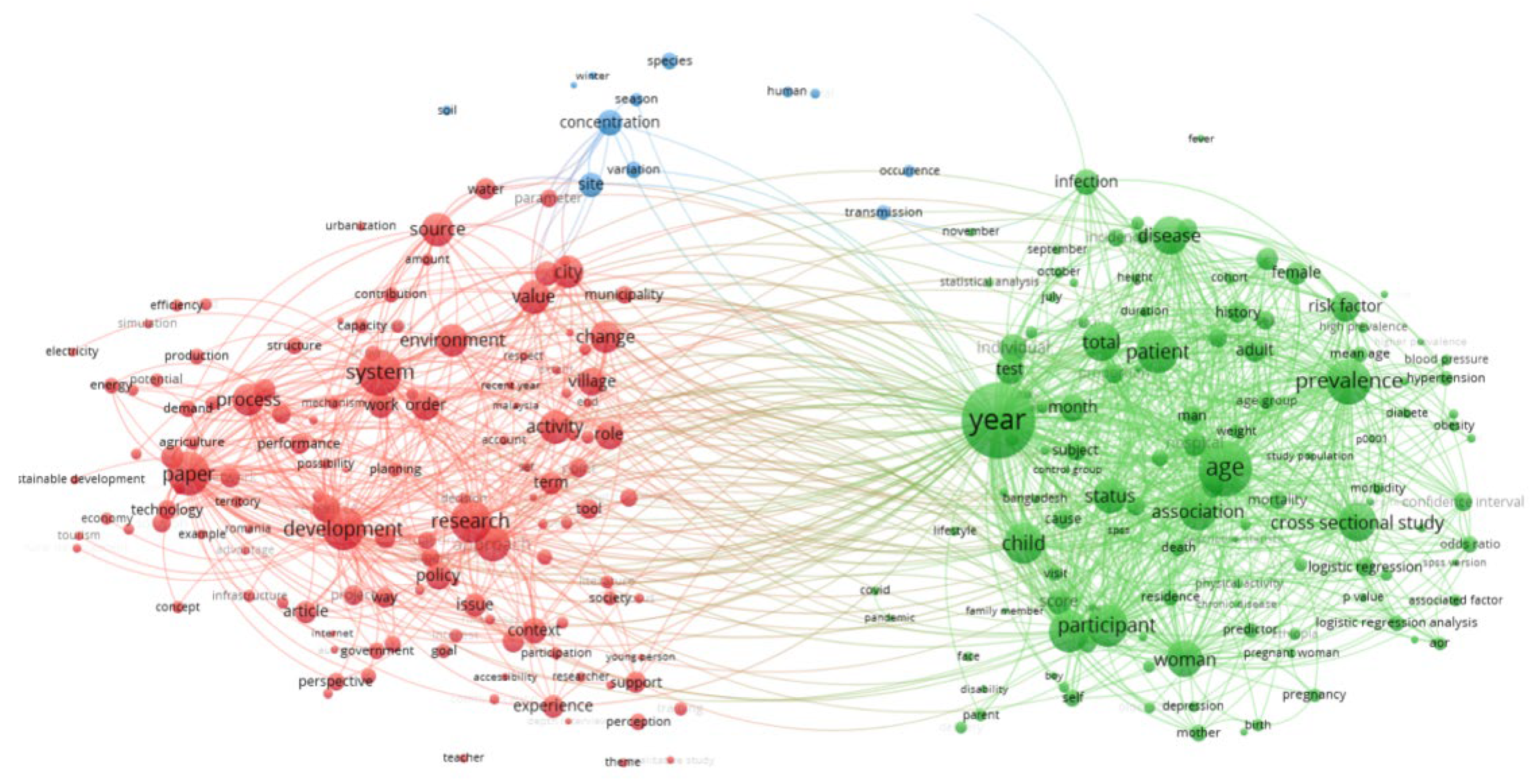
Rural areas continue to attract considerable research attention around the world. The topic of this Special Issue was selected based on a bibliographic analysis of articles published in WoS-indexed journals with the use of selected keywords. Articles containing the words “rural area” were selected from the database of papers published between 2017 and 2021. The search produced 25,000 records. The next stage of the analysis involved the VOSviewer software tool that can be used to construct and visualize co-occurrence networks of important terms extracted from a body of scientific literature.
The results of the analysis are presented in Figure 1 (only the links between the words that were identified at least 60 times as the keywords related to the term “rural area” are shown). The size of the node containing a given keyword denotes the frequency of its occurrence in published articles. An analysis of the results revealed that the searched term occurred primarily in two fields of research: socio-economic (in green) and spatial (red).
The main keywords in research papers dedicated to socio-economic development were: patient, child, age, participant, and woman. The results of these research studies were presented in both the temporal (year, month) and the quantitative (total, prevalence) approach.
When typical editorial terms were disregarded (paper, article, research, approach, issue, context, case study), the predominant keywords in the articles focusing on the spatial development of rural areas were: development, system, environmental value, municipality, city, village, and policy.
The analysis confirmed that changes in geographic space have various causes and origins. Changes resulting from intentional actions are generally referred to as land management, whereas changes that occur as side-effects of intentional actions are mostly destructive in nature. In the spatial planning process, which is a land management tool, the term “spatial development” is often defined as a process of directed change that transforms geographic space from simpler and less effective systems to more complex and more optimal systems [11]. This definition of development is correct from the economic point of view, but it may not be appropriate in the environmental approach to land management. Sustainable development, a concept that combines various approaches to development, is the preferred mode of development. Sustainable development aims to balance all functions, including economic, social, ecological, cultural and spatial. This innovative concept represents the highest and the most desirable form of development in both science and practice.
Rural land management is one of the goals of spatial planning, and rural areas should be transformed in a sustainable manner. The ongoing debate on changes in rural areas raises the following questions:
What is the future of rural space?
Is the rural–urban divide a valid concept in the contemporary world?
What tools should be applied to develop an optimal model of rural space?
What is the role of spatial planning in the process of transforming rural areas?
Rural areas are often regarded as peripheral areas. However, rural areas can be highly attractive living and working environments on account of their unique natural and scenic attributes, including picturesque landscapes, presence of water bodies, forests and areas of high natural value. In recent years, rural areas in the European Union (EU) have been considerably transformed through Common Agricultural Policy (CAP) mechanisms. European funds promote agricultural restructuring, farm modernization and multifunctional rural development.
This Special Issue is dedicated to rural space modeling. It contains articles that evaluate the existing status of rural space and describe the necessary conditions for rural development. The presented papers emphasize the importance of rural space modeling in rural development. The demand for land that can be converted to non-agricultural uses is very high in rural areas, in particular those situated in the direct vicinity of urban agglomerations. The main aim of spatial planning is to eliminate or alleviate spatial conflicts at the rural–urban interface. All countries have implemented laws and regulations that promote rational planning and land management. Planning documents and decisions can impose limitations on land management and land-use type, but the absence of these regulatory instruments considerably hampers development. Zoning decisions (in Poland, zoning decisions define the permitted type of development and land use) are only temporary solutions that lead to monofunctional development of rural areas, residential fragmentation and undermine harmonious spatial development. Residential estates comprising single-family homes and apartment buildings are increasingly often developed in suburban areas [12]. As a result, small towns in the proximity of large cities are absorbed into the metropolitan area [13,14,15].
The main research objective conducted by Kurowska et al. [1] was to evaluate the applicability of geographic information system (GIS) tools (data, tools, and multidimensional analyses) to the implementation of sustainable development principles in rural areas. The study covered rural and nonurbanized areas in Poland, especially farmland, forests [16,17], fisheries [18], and farms [19]. GIS systems allow us to formulate, in a structured and formal way, models that reflect both the current state and forecast changes that will occur in space.
A different approach was used by Juknelienė et al. [20]. The authors proved that he spatially explicit assessment of land use and land-use change patterns can identify critical areas and provide insights to improve land management policies and associated decisions. Mozgeris and Juknelienė’s [21] study focused on modelling future land use development on the example of Lithuania. The next article (Stręk et al.) dealt with land fragmentation and the distribution of plots in rural areas. The authors attempted to develop a universal land exchange algorithm for eliminating the external plot patchwork [22].
Chen et al. [9] conducted a case study on 38 villages to develop a practical village planning strategy for different types of villages. The aim of the study conducted by Kopáček [10] was to assess whether there is an optimal level of civic participation in the land-use planning process. A secondary aim of this research was to suggest suitable ways of facilitating an optimal degree of participation in the land-use planning process. Finally, Kaminska and Mularczyk [8] determined the attractiveness of central public spaces in small Polish towns based on a spatial order analysis.
The presented articles also evaluate the impact of EU funds on regional changes in agricultural development and management of green areas. Jurjević et al. [23], using the example of Serbia, discussed a regional spatial approach to differences in rural economic development. Rudnicki et al. [24] were attempted to synthesise the diversity of CAP financial support using spatial typology methods. The researched support measures were divided into three basic directions for developing agriculture: ecology, environment and habitat. The study was conducted on the example of Poland, and the basic territorial unit of analysis was the commune. It was shown that support for environmentally friendly activities in Poland related to almost 10% of the total farm area.
Kupren and Hakuć-Błażowska [25] have demonstrated that hunting is an important part of socio-economic activities, particularly in rural areas. It is estimated that in the EU alone, hunting can be worth approximately EUR 16 billion, and creates 100–120 thousand jobs.
Rural space modeling was the one of the main topics of scientific debate during the 36th International Seminar on Rural Geography organized by the University of Warmia and Mazury in Olsztyn on 21–22 June 2021 in Olsztyn, Poland.
Author Contributions
Conceptualization, K.K. and C.K.; methodology, C.K. and K.K. writing—original draft preparation, K.K. and C.K.; writing—review and editing, K.K. and C.K. All authors have read and agreed to the published version of the manuscript.
Funding
This research received no external funding.
Institutional Review Board Statement
Not applicable.
Informed Consent Statement
Not applicable.
Data Availability Statement
The study did not report any data.
Acknowledgments
We thank all the reviewers for their feedback on earlier versions of the manuscripts in this Special Issue.
Conflicts of Interest
The authors declare no conflict of interest.
References
- Kurowska, K.; Marks-Bielska, R.; Bielski, S.; Aleknavičius, A.; Kowalczyk, C. Geographic information systems and the sustainable development of rural areas. Land 2021, 10, 6. [Google Scholar] [CrossRef]
- Cloke, P.J.; Doel, M.A.; Matless, D.; Thrift, N.; Phillips, M. Writing the Rural: Five Cultural Geographies; Sage: London, UK, 1994. [Google Scholar]
- Cloke, P.J. (Ed.) Country Visions; Pearson Education: New York, NY, USA, 2003. [Google Scholar]
- Coburn, A.F.; MacKinney, A.C.; McBride, T.D.; Mueller, K.J.; Slifkin, R.T.; Wakefield, M.K. Choosing rural definitions: Implications for health policy. Rural. Policy Res. Inst. Health Panel 2007, 2, 1–8. [Google Scholar]
- Ilbery, B. Dimensions of rural change. In The Geography of Rural Change, Ilbery, B., Ed.; Longman: Harlow, 1998; pp. 1–10. [Google Scholar]
- Bański, J.; Mazur, M. Classification of rural areas in Poland as an instrument of territorial policy. Land Use Policy 2016, 54, 1–17. [Google Scholar] [CrossRef]
- Różycka-Czas, R.; Salata, T.; Gawroński, K.; Czesak, B.; Cegielska, K. The use of geographic information systems to spatial order evaluation. Acta Sci. Polonorum. Form. Circumiectus 2016, 15, 73. [Google Scholar] [CrossRef] [Green Version]
- Kamińska, W.; Mularczyk, M. Attractiveness of Central Public Spaces in Small Polish Towns Based on a Spatial Order Analysis. Land 2021, 10, 1327. [Google Scholar] [CrossRef]
- Chen, J.; Wang, C.; Dai, R.; Xu, S.; Shen, Y.; Ji, M. Practical Village Planning Strategy of Different Types of Villages—A Case Study of 38 Villages in Shapingba District, Chongqing. Land 2021, 10, 1143. [Google Scholar] [CrossRef]
- Kopáček, M. Land-Use Planning and the Public: Is There an Optimal Degree of Civic Participation? Land 2021, 10, 90. [Google Scholar] [CrossRef]
- Kurowska, K.; Kietlinska, E. Spatial planning as a tool for rural area management. In Proceedings of the Geographic Information Systems Conference and Exhibition “GIS ODYSSEY 2017”, Trento, Italy, 4–8 September 2017; p. 221. [Google Scholar]
- Kurowska, K.; Kryszk, H.; Marks-Bielska, R.; Mika, M.; Leń, P. Conversion of agricultural and forest land to other purposes in the context of land protection: Evidence from Polish experience. Land Use Policy 2020, 95, 104614. [Google Scholar] [CrossRef]
- Kowalczyk, C.; Kil, J.; Moldovan, C.S. Comparison of changes in urbanized areas in Poland and Romania. Transylvanian Rev. 2018, 2, 7. [Google Scholar]
- Parry, J.A.; Ganaie, S.A.; Bhat, M.S. GIS based land suitability analysis using AHP model for urban services planning in Srinagar and Jammu urban centers of J&K, India. J. Urban Manag. 2018, 7, 46–56. [Google Scholar] [CrossRef]
- Kowalczyk, C.; Kil, J.; Kurowska, K. Dynamics of development of the largest cities—Evidence from Poland. Cities 2019, 89, 26–34. [Google Scholar] [CrossRef]
- Kurowska, K.; Kryszk, H.; Marks-Bielska, R.; Kietlińska, E. Spatial analysis of afforestation in Poland under Rural Development Programme 2007–2013. In Proceedings of the Annual 20th International Scientific Conference Proceedings Research for Rural Development 2014, Jelgava, Latvia, 21–23 May 2014. [Google Scholar]
- Kurowska, K.; Kryszk, H. Profitability of the farmland afforestation within the Rural Development Programme. Sylwan 2017, 161, 1035–1045. [Google Scholar] [CrossRef]
- Kurowska, K.; Kryszk, H.; Gwiaździńska-Goraj, M. Sustainable development of coastal areas-Polish experience following accession to the European Union based on the example of Fisheries Local Action Groups (FLAGs) during 2007–2013. Acta Adriat. 2014, 55, 2. [Google Scholar]
- Kurowska, K.; Rudnicki, R. Changes in land use in Poland—Comparative study of period 2002–2010. In Proceedings of the 7th International Scientific Conference Rural Development 2015: Towards the Transfer of Knowledge, Innovations and Social Progress, Kaunas, Lithuania, 19–20 November 2015. [Google Scholar] [CrossRef]
- Juknelienė, D.; Kazanavičiūtė, V.; Valčiukienė, J.; Atkocevičienė, V.; Mozgeris, G. Spatiotemporal Patterns of Land-Use Changes in Lithuania. Land 2021, 10, 619. [Google Scholar] [CrossRef]
- Mozgeris, G.; Juknelienė, D. Modeling Future Land Use Development: A Lithuanian Case. Land 2021, 10, 360. [Google Scholar] [CrossRef]
- Stręk, Ż.; Leń, P.; Wójcik-Leń, J.; Postek, P.; Mika, M.; Dawid, L. A Proposed Land Exchange Algorithm for Eliminating the External Plot Patchwork. Land 2021, 10, 64. [Google Scholar] [CrossRef]
- Jurjević, Ž.; Zekić, S.; Đokić, D.; Matkovski, B. Regional Spatial Approach to Differences in Rural Economic Development: Insights from Serbia. Land 2021, 10, 1211. [Google Scholar] [CrossRef]
- Rudnicki, R.; Wiśniewski, Ł.; Biczkowski, M. A Spatial Typography of Environmentally Friendly Common Agricultural Policy Support Relevant to European Green Deal Objectives. Land 2021, 10, 1092. [Google Scholar] [CrossRef]
- Kupren, K.; Hakuć-Błażowska, A. Profile of a Modern Hunter and the Socio-Economic Significance of Hunting in Poland as Compared to European Data. Land 2021, 10, 1178. [Google Scholar] [CrossRef]
Figure 1.
Visualization of the co-occurrence networks of the keywords in scientific publications containing the term “rural area”.
Figure 1.
Visualization of the co-occurrence networks of the keywords in scientific publications containing the term “rural area”.

Publisher’s Note: MDPI stays neutral with regard to jurisdictional claims in published maps and institutional affiliations. |
© 2022 by the authors. Licensee MDPI, Basel, Switzerland. This article is an open access article distributed under the terms and conditions of the Creative Commons Attribution (CC BY) license (https://creativecommons.org/licenses/by/4.0/).
Share and Cite
MDPI and ACS Style
Kurowska, K.; Kowalczyk, C. Rural Space Modeling—Contemporary Challenges. Land 2022, 11, 173. https://doi.org/10.3390/land11020173
AMA Style
Kurowska K, Kowalczyk C. Rural Space Modeling—Contemporary Challenges. Land. 2022; 11(2):173. https://doi.org/10.3390/land11020173
Chicago/Turabian StyleKurowska, Krystyna, and Cezary Kowalczyk. 2022. "Rural Space Modeling—Contemporary Challenges" Land 11, no. 2: 173. https://doi.org/10.3390/land11020173
Note that from the first issue of 2016, this journal uses article numbers instead of page numbers. See further details here.