
Assessment of Huixian Karst Wetland for Local Water Augmentation in Guilin, China
 , ,
, ,
Abstract
:1. Introduction
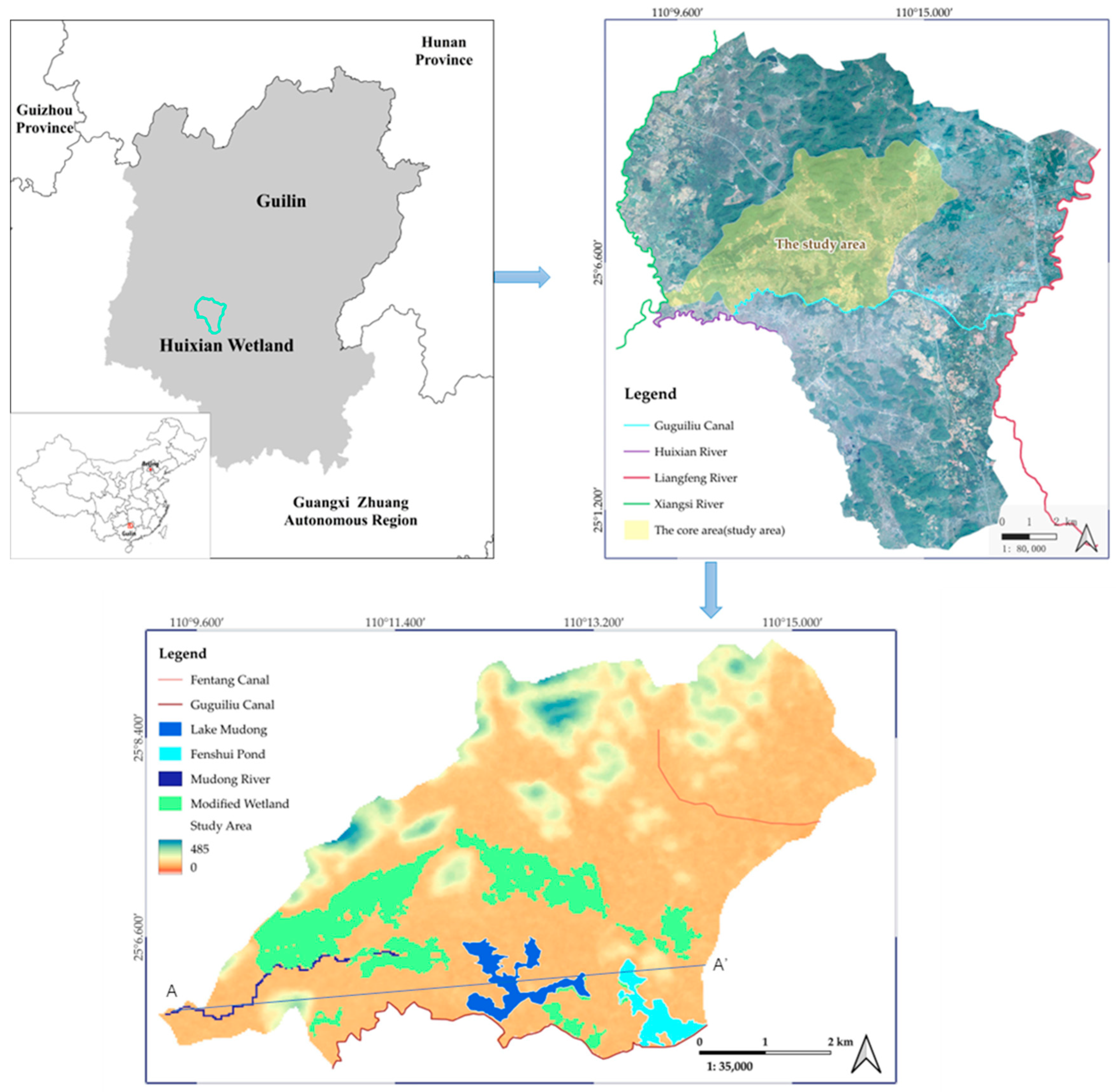
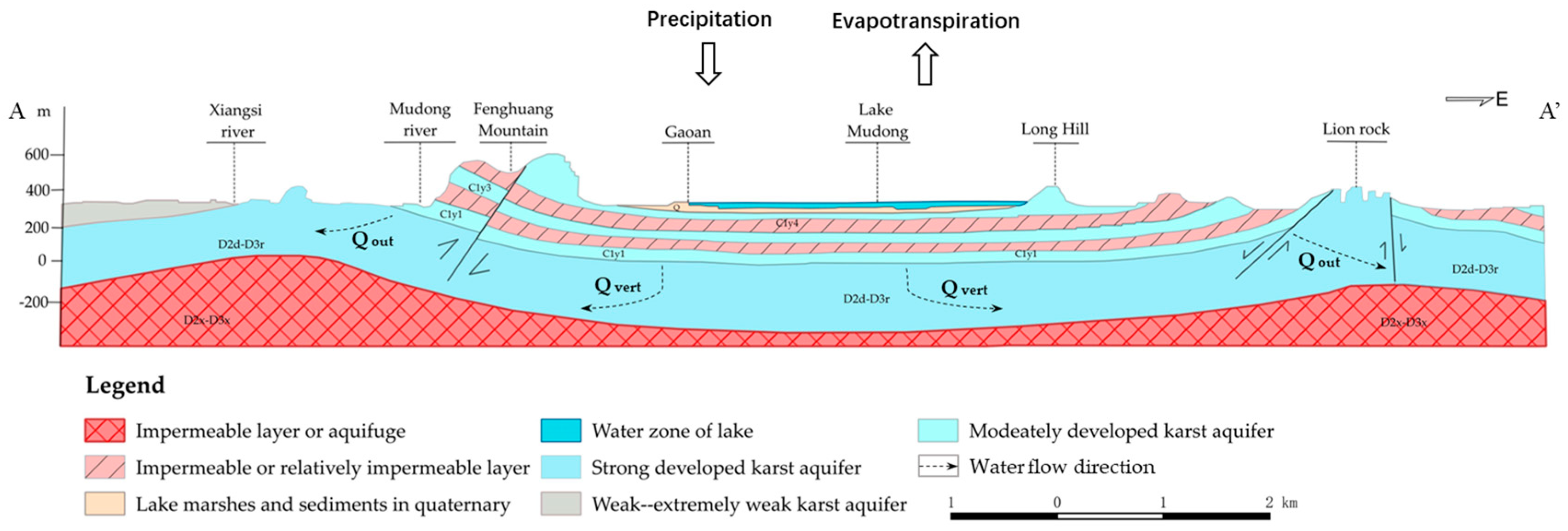
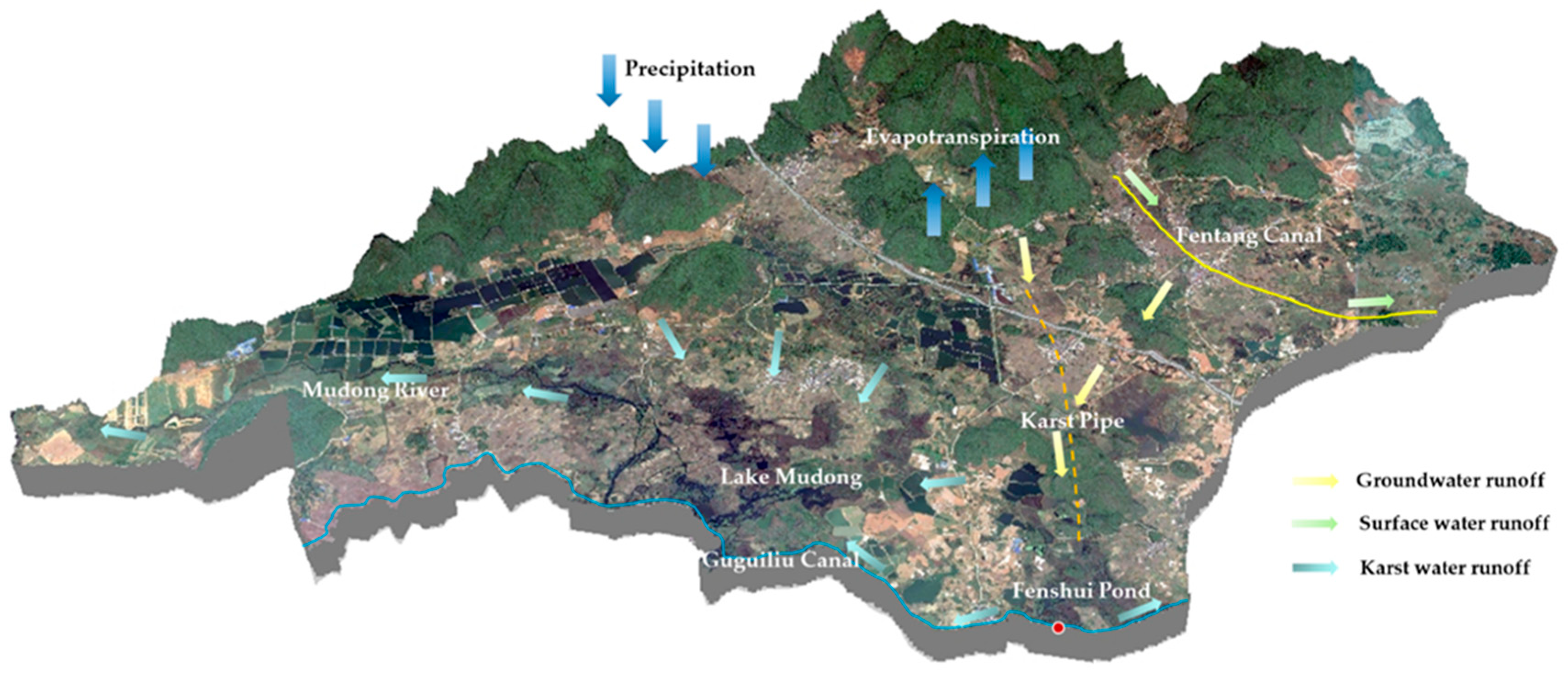
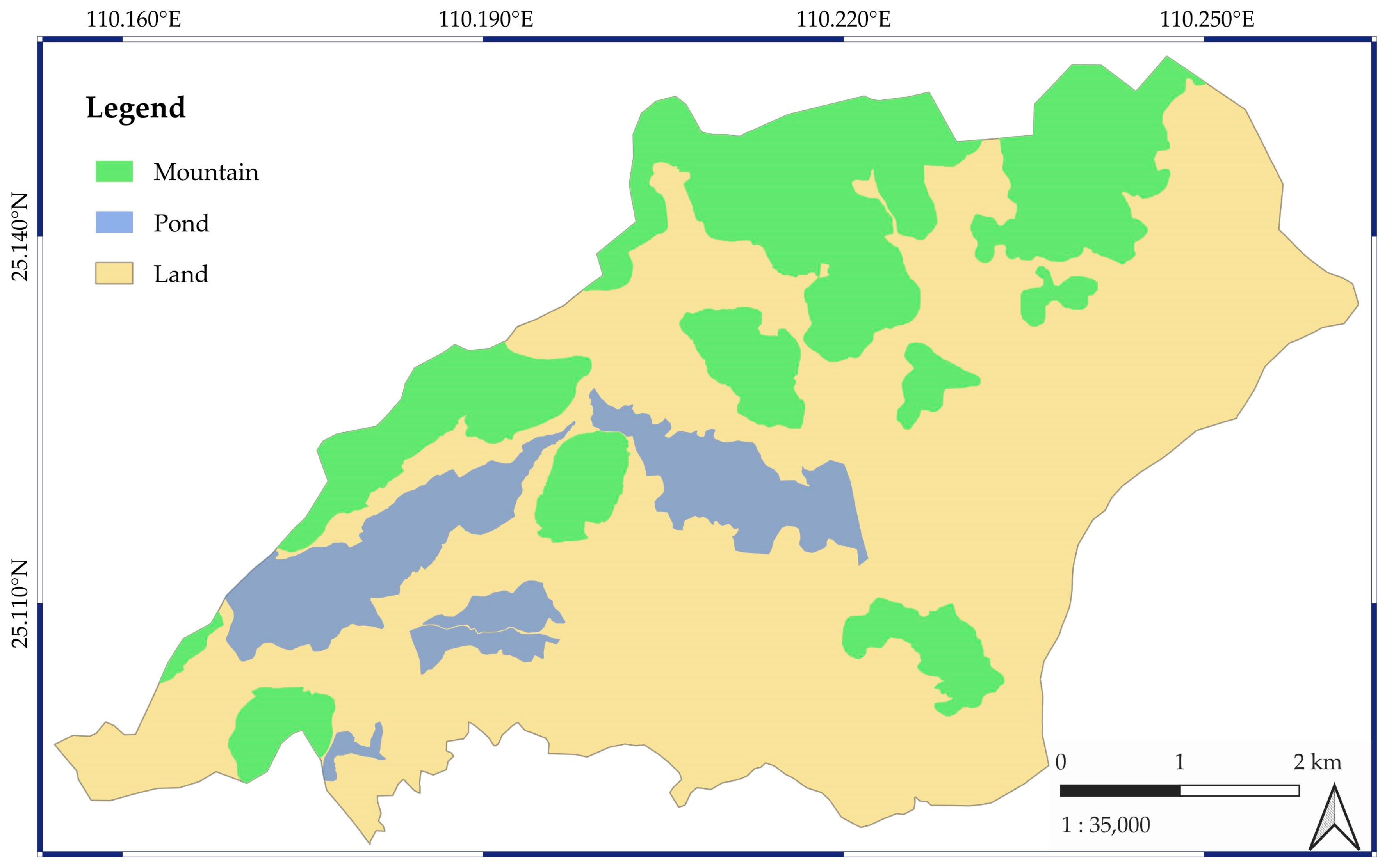
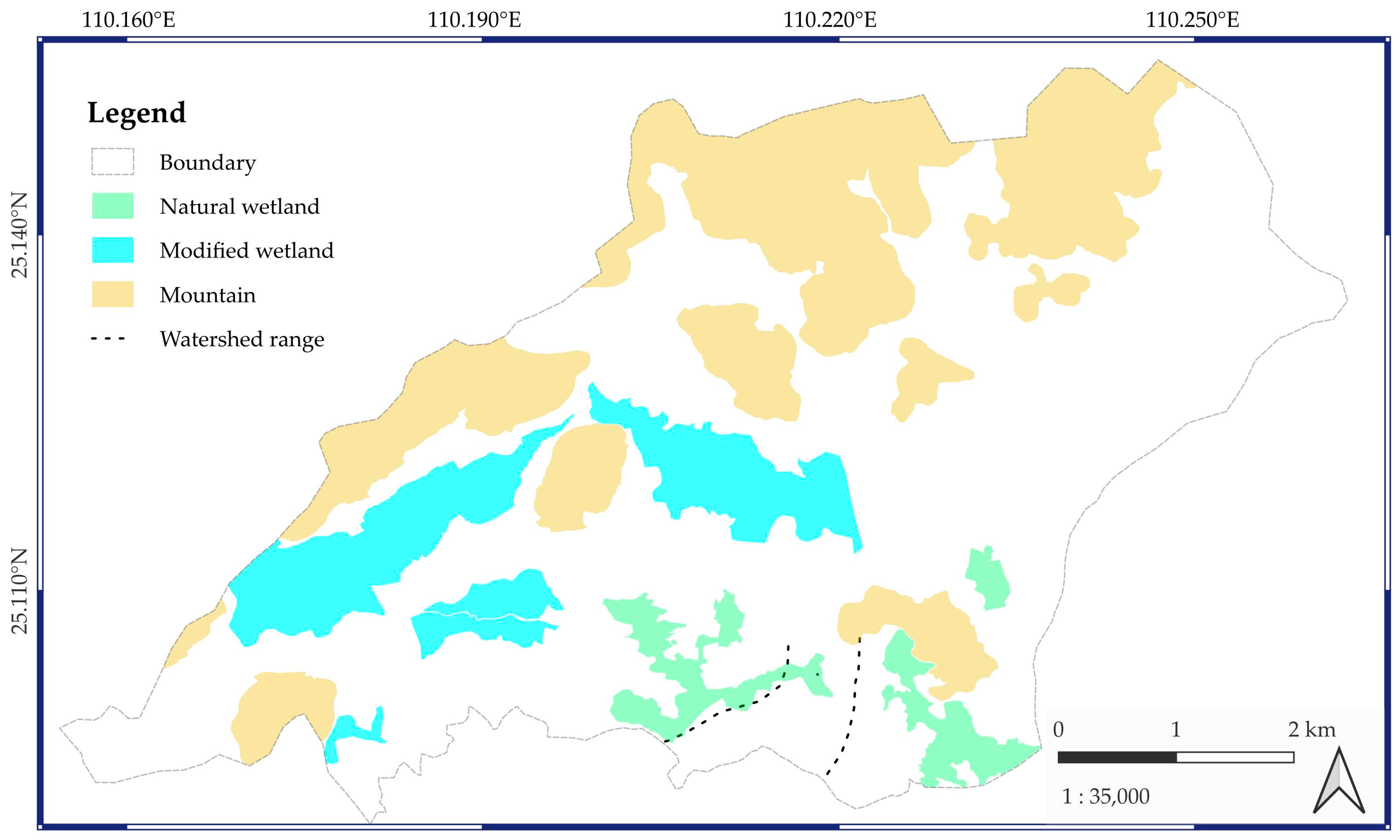
2. Site Description
3. Methodology
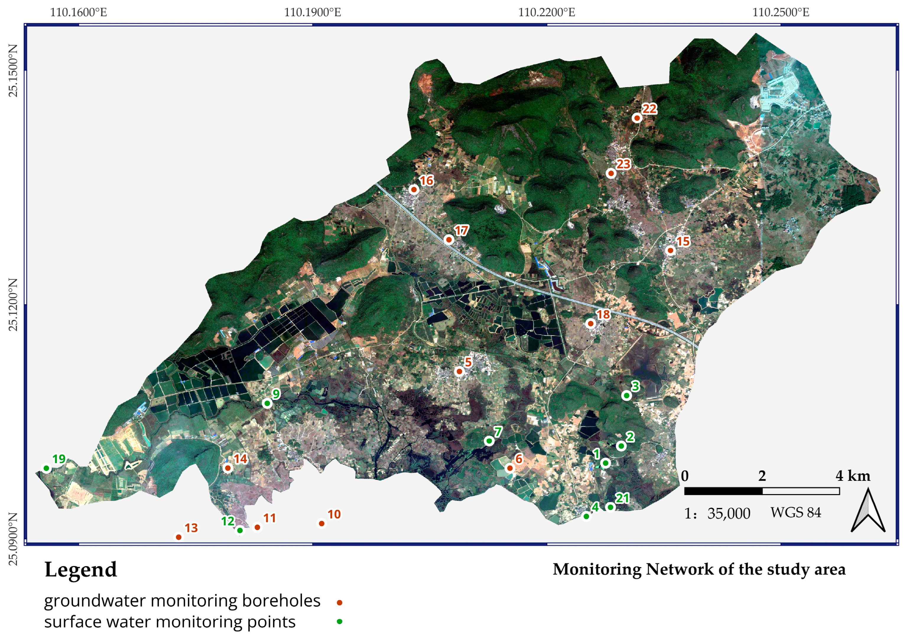
3.1. Field Investigation
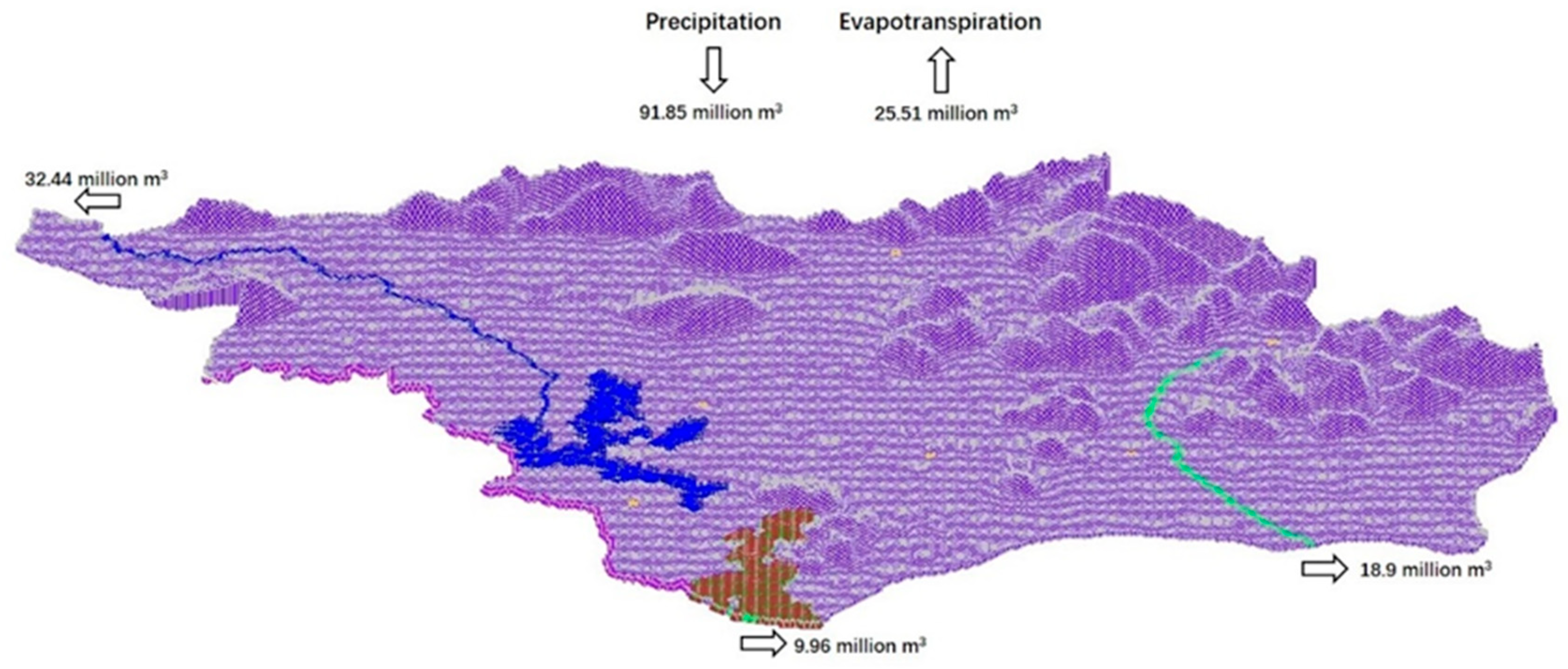
3.2. Water Balance
- Precipitation and inflow
- 2.
- Evapotranspiration
- 3.
- Runoff
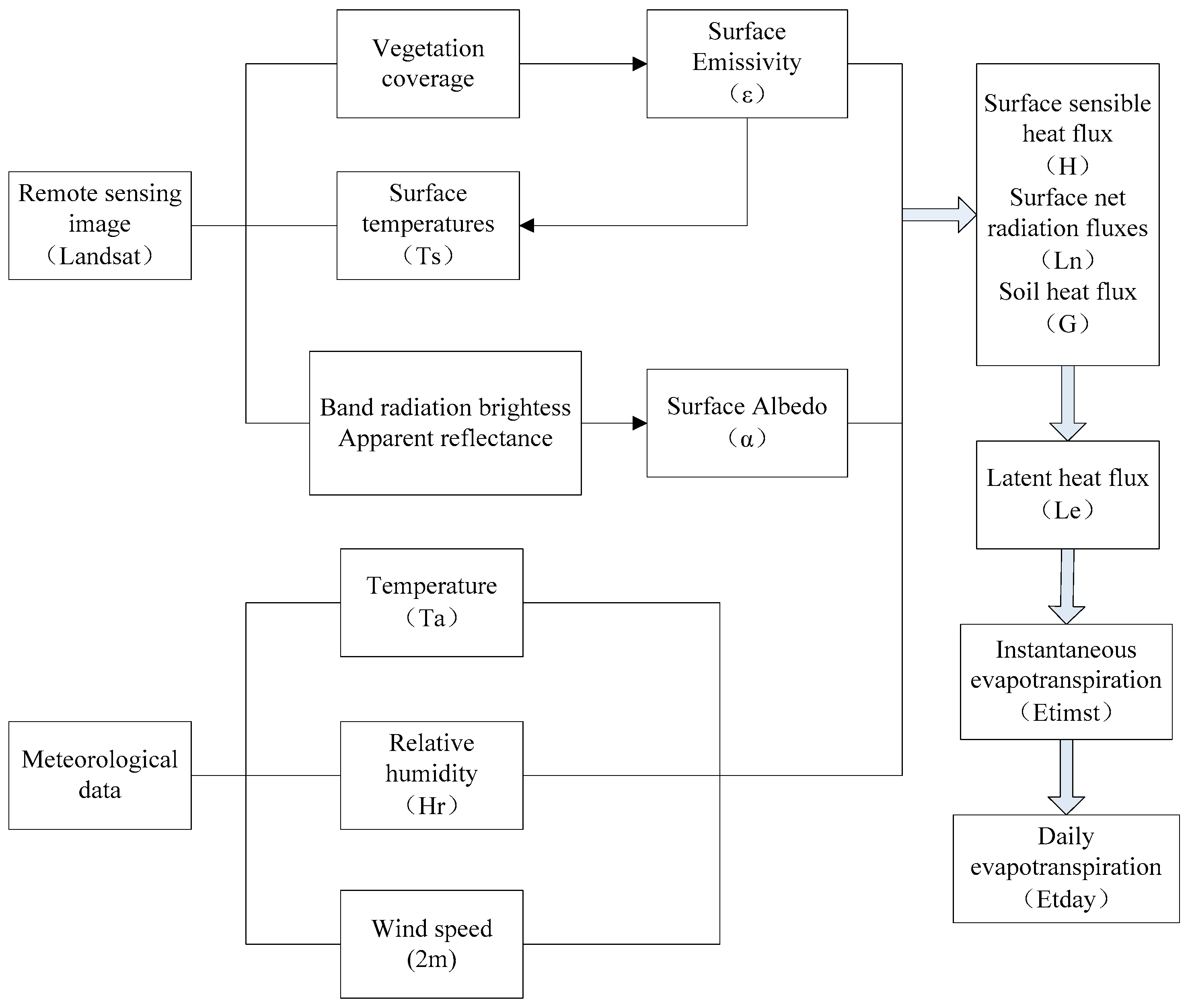
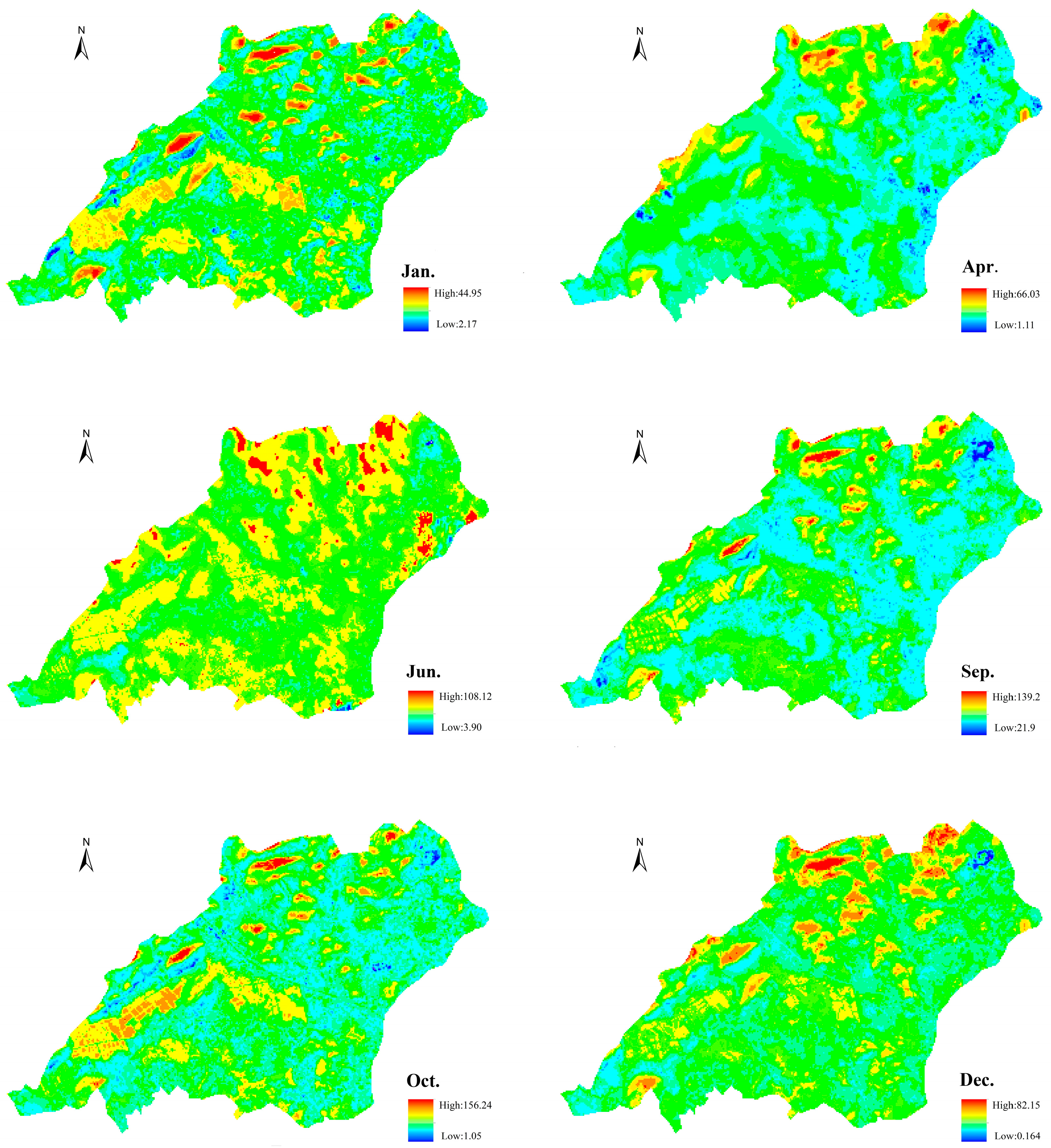
3.3. Remote Sensing
3.4. Numerical Simulation
4. Results and Discussion
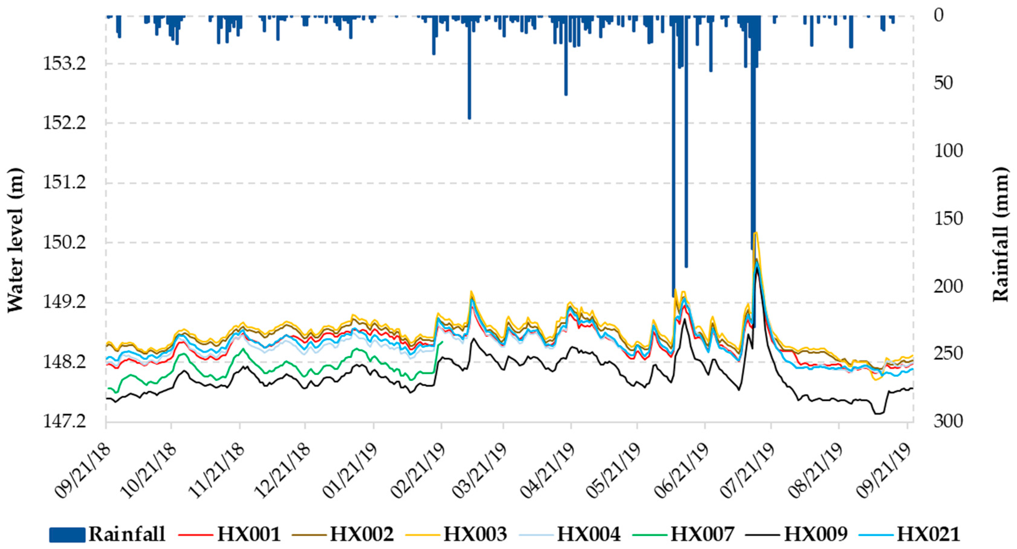
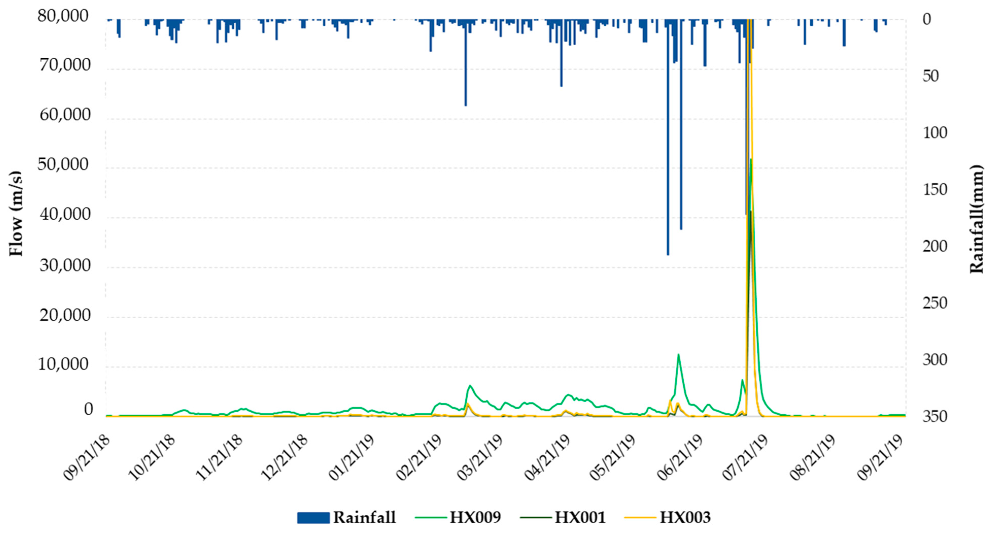
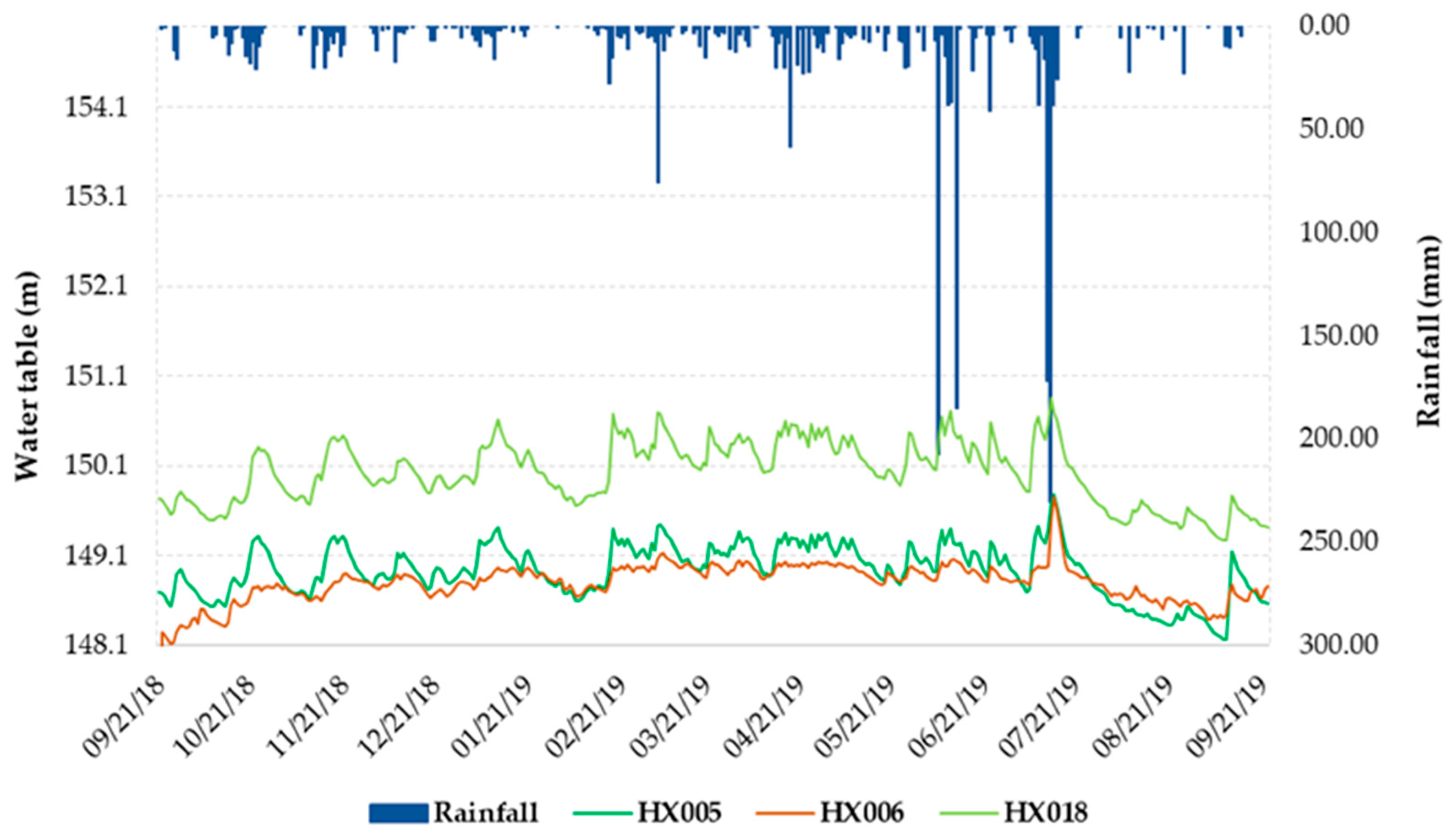
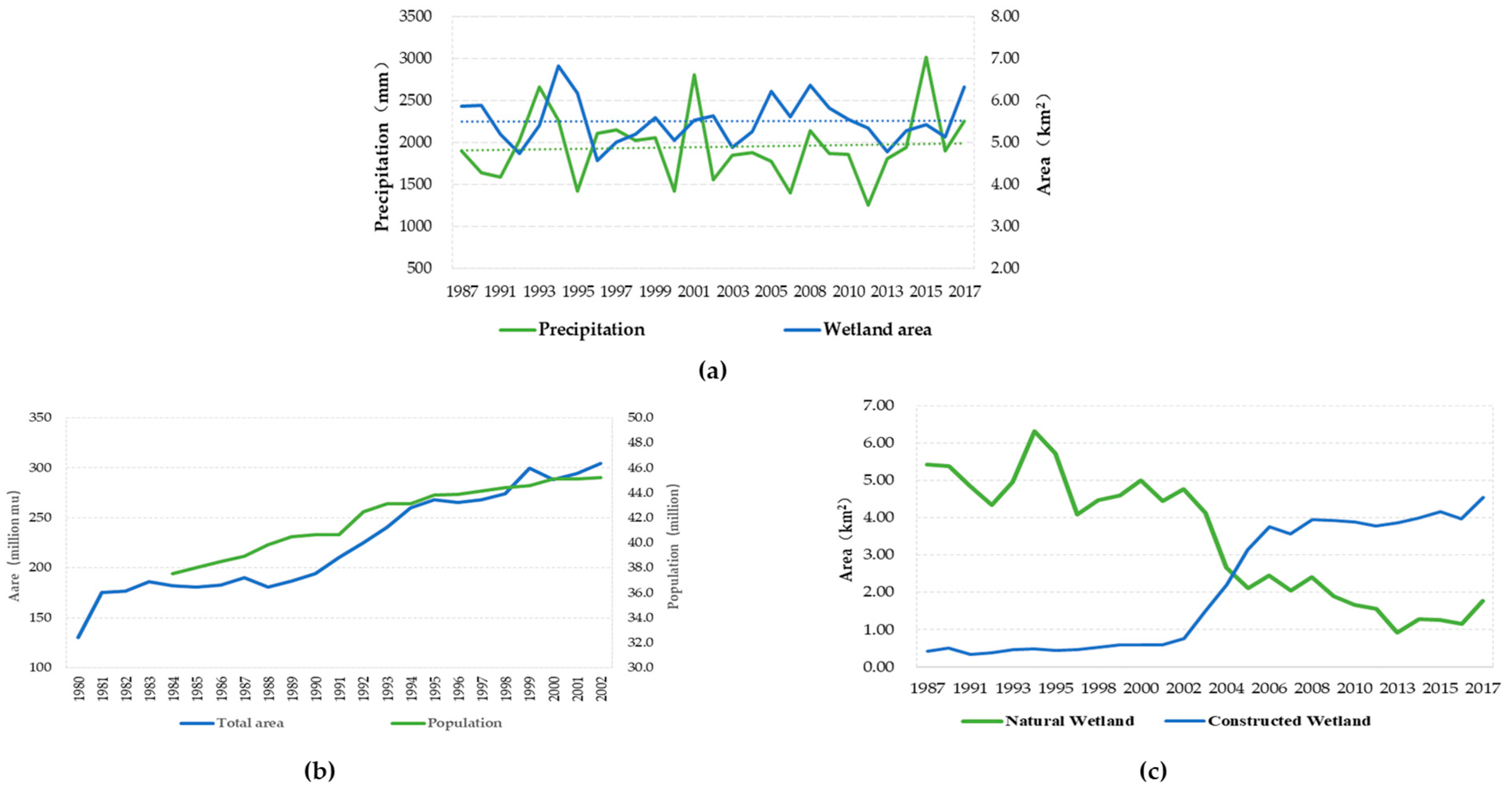
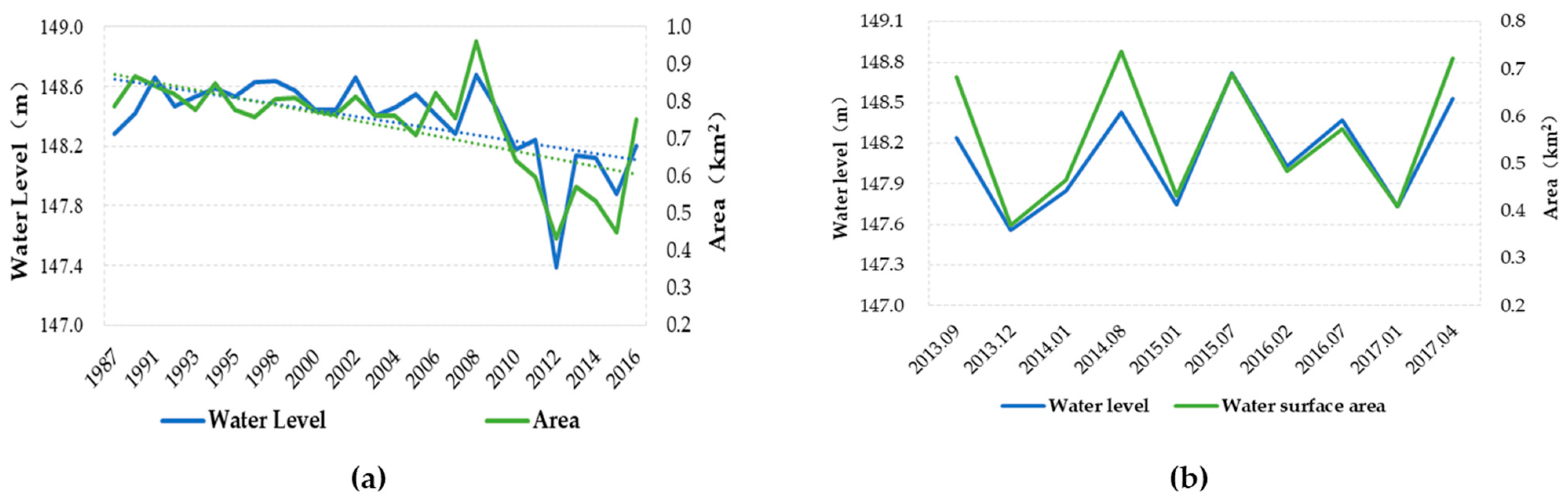
4.1. Hydrological Characteristics of the Wetland
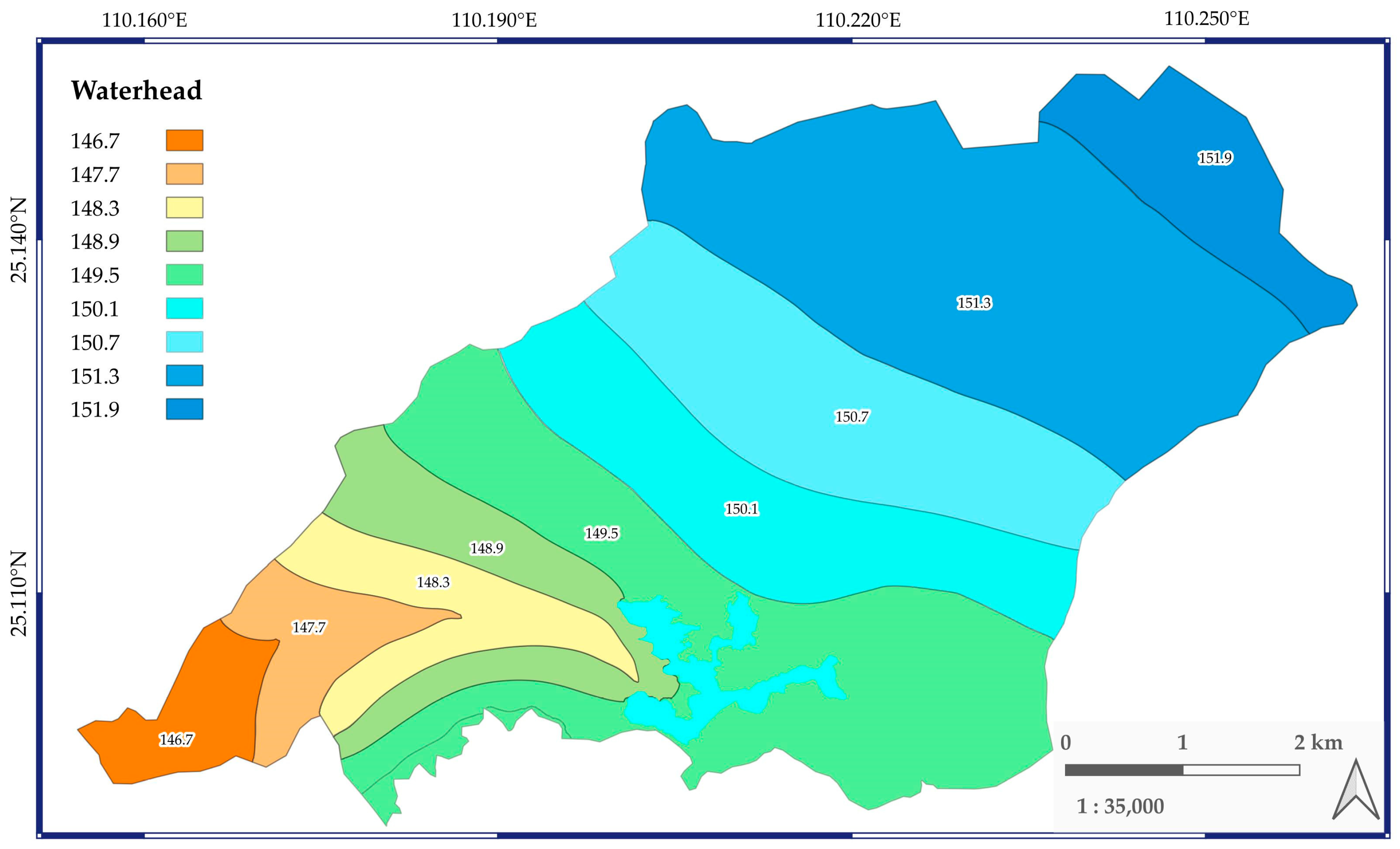
4.2. Flow Regime of the Wetland
5. Conclusions
Author Contributions
Funding
Data Availability Statement
Acknowledgments
Conflicts of Interest
References
- Dugan, P.J. Wetland Conservation: A Review of Current Issues and Required Action; IUCN Communications Unit: Gland, Switzerland, 1990; 96p. [Google Scholar]
- Ezealor, A.U.; Giles, R.H., Jr. Ecological profile of a Sahelian wetland: Toward understanding the need for national wetland policies. Wetl. Ecol. Manag. 1996, 4, 15–30. [Google Scholar] [CrossRef]
- Joyce, C. Preface: Wetland services and management. Hydrobiologia 2012, 692, 1–3. [Google Scholar] [CrossRef]
- Costanza, R.; Norton, B.G.; Haskell, B.D. Ecosystem Health: New Goals for Environmental Management; Island Press: Washington, DC, USA, 1992. [Google Scholar]
- Spangenberg, J.H.; Lorek, S. Environmentally sustainable household consumption: From aggregate environmental pressures to priority fields of action. Ecol. Econ. 2002, 43, 127–140. [Google Scholar] [CrossRef]
- Zedler, J.B.; Kercher, S. Wetland resources: Status, trends, ecosystem services, and restorability. Annu. Rev. Environ. Resour. 2005, 30, 39–74. [Google Scholar] [CrossRef]
- Sullivan, P.L.; Price, R.M.; Schedlbauer, J.; Saha, A.; Gaiser, E.E. The Influence of Hydrologic Restoration on Groundwater-Surface Water Interactions in a Karst Wetland, the Everglades (FL, USA). Wetlands 2014, 34 (Suppl. S1), 23–35. [Google Scholar] [CrossRef]
- García-Álvarez, M.T.; Moreno, B.; Soares, I. Analyzing the environmental and resource pressures from European energy activity: A comparative study of EU member states. Energy 2016, 115, 1375–1384. [Google Scholar] [CrossRef]
- Asomani-Boateng, R. Urban wetland planning and management in Ghana: A disappointing implementation. Wetlands 2019, 39, 251–261. [Google Scholar] [CrossRef]
- Li, Y.; Guo, C.; Ma, Z. Discussion on hydrogeological conditions of Guilin Huixian Karst Wetland. In Proceedings of the 5th China Water Forum—Environmental Change and Water Security, Nanjing, China, 11–12 November 2007; pp. 842–845. (In Chinese). [Google Scholar]
- Chen, Y.; Qiu, K.; Wu, L.; Luo, Q.; Su, C. Methanogenic community structure, abundance, and activity in Huixian karst wetland, Guilin, China. Chin. J. Appl. Environ. Biol. 2017, 23, 959–967. (In Chinese) [Google Scholar]
- Chen, J.; Luo, M.; Liao, C.; Ma, R.; Zhou, H.; Zou, S.; Chen, Z. Review of Eco-hydrological Process in Karst Wetlands of China. Geol. Sci. Technol. Inf. 2019, 38, 221–230. (In Chinese) [Google Scholar]
- Cartwright, J.M.; Wolfe, W.J. Increasing Hydroperiod in a Karst-depression Wetland Based on 165 Years of Simulated Daily Water Levels. Wetlands 2021, 41, 75. [Google Scholar] [CrossRef]
- Ma, Z.; Cai, D.; Jiang, Z. About Karst Wetland Classification System. J. Guangxi Norm. Univ. Nat. Sci. Ed. 2009, 27, 101–106. [Google Scholar]
- Whittaker, R. Evolution and measurement of species diversity. Taxon 1972, 21, 213–251. [Google Scholar] [CrossRef]
- Solomon, A. Transient response of forests to CO2 induced climate change: Simulation modeling experiments in eastern North America. Oecologia 1986, 68, 567–579. [Google Scholar] [CrossRef]
- Belotelov, N.V.; Bogatyrev, B.G.; Kirilenko, A.P.; Venevsky, S.V. Modelling of time-dependent biomes shifts under global climate changes. Ecol. Model. 1996, 87, 29–40. [Google Scholar] [CrossRef]
- Wang, S.J. The Most Serious Eco-geologically environmental Problem in Southwestern China—Karst Rocky Desertification. Bull. Mineral. Petrol Geochem. 2003, 22, 120–126. [Google Scholar]
- Jie, G.; Shao, X.; Cheng, H. Primary Eco-environment Problems and Their Countermeasures in Karst Region of Southwest China. Res. Agric. Mod. 2005, 5, 374–377. (In Chinese) [Google Scholar]
- Zhang, X.; Wang, S.; Cao, J.; Wang, K.; Meng, T.; Bai, X. Characteristics of water loss and soil erosion and some scientific problems on karst rocky desertification in Southwest China karst area. Carsologica Sin. 2010, 3, 274–279. (In Chinese) [Google Scholar]
- Peng, D.W.; Zhou, Q.W.; Wei, X.C.; Li, H.G.; Tang, X.; Yan, W.H. Change of water use efficiency and its response to meteorological factors in karst area of Southwest China. Acta Ecol. Sin. 2021, 41, 9470–9480. (In Chinese) [Google Scholar]
- Song, T.; Yu, X.; Zou, S.; Zhang, L.; Liu, P.; Zhao, Y.; Shen, L. Preliminary study on the construction of evaluation index system for karst wetland degradation. Carsologica Sin. 2020, 39, 673–681. (In Chinese) [Google Scholar]
- Cai, D.; Ma, Z. Study on Wetland Ecosystem in Huixian Wetland; Geological Publishing House: Beijing, China, 2012. (In Chinese) [Google Scholar]
- Xing, M.; Li, H.; Jiang, L.; Tu, Y.; Zeng, H.; Wang, D. Spatio-temporal characteristics of water pollutants in surrounding water system of Lingui and Huixian karst wetlands. J. Guilin Univ. Technol. 2019, 39, 168–176. (In Chinese) [Google Scholar]
- Li, L.; Li, J.; Wei, C.; Zhou, J.; Zhang, Q.; Liu, H.; Wang, J.; Qiao, Z. Analysis and Evaluation of Water Quality Status in Huixian Wetland of Guangxi. J. Guilin Univ. Technol. 2019, 39, 693–699. (In Chinese) [Google Scholar]
- Zhao, Y.; Zou, S.; Shen, H.; Zhou, C.; Fan, L.; Zhu, D.; Li, J. Dynamic Characteristics and Equilibrium of Water Level of the Karst Groundwater System Beneath the Huixian Wetland. Carsologica Sin. 2021, 40, 325–333. [Google Scholar]
- Wu, Y.; Mo, Y.; Zou, S. Ecologic Problem and Protection Method of Karst Wetland in Huixian, Guilin. Carsologica Sin. 2006, 25, 85–88. (In Chinese) [Google Scholar]
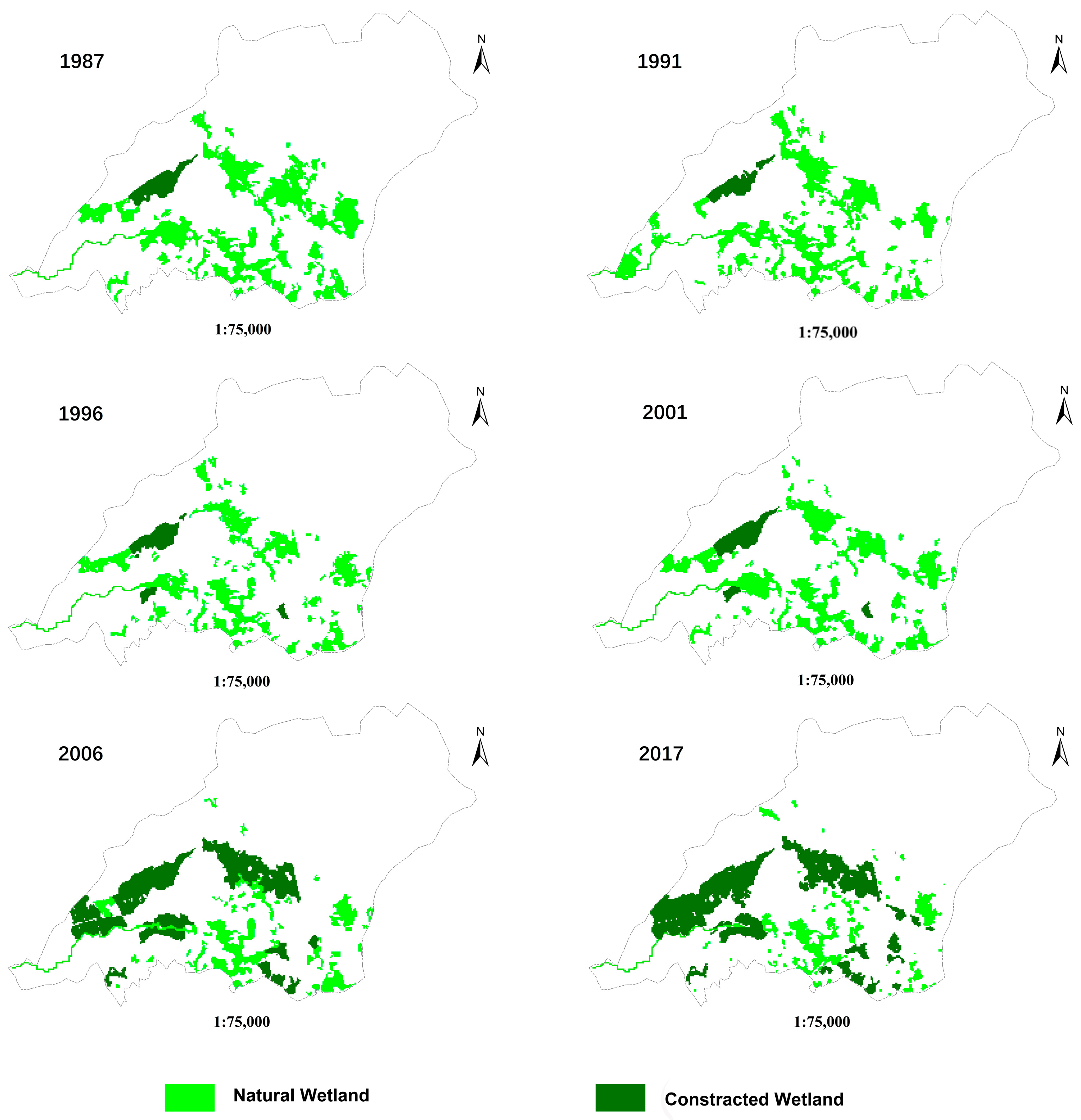
- Cai, D.; Ma, Z.; Zhao, X.; Wang, K. Remote Sensing Supervision on Spatio-temporal Evolution of Karst Wetland in Recent 40 years in Huixian District of Guilin, China. J. Guangxi Norm. Univ. Nat. Sci. Ed. 2009, 27, 111–117. (In Chinese) [Google Scholar]
- Zhu, D.; Zou, S.; Zhou, C.; Zhao, Y.; Lu, H.; Xie, H. Dynamic Characteristics of Water Level and Hydro-Ecological Effects in Huixian Karst Wetland in Guilin. Carsologica Sin. 2021, 40, 661–670. (In Chinese) [Google Scholar]
- Zou, S.; Zhou, C.; Zhu, D.; Lin, Y.; Fan, L.; Xie, H.; Wang, J.; Li, J. Scientific protection of Huixian karst wetland in Guilin. China Min. Mag. 2019, 28 (Suppl. S1), 353–357. (In Chinese) [Google Scholar]
- Li, H.; Jiang, Z.; Ma, Z.; Yang, Q.; Luo, W.; Yin, H.; Wang, Y. The research of the health assessment and compensation mechanism in Huixian karst wetland of Guilin. Soil Water Conserv. China 2013, 1, 61–63. (In Chinese) [Google Scholar]
- Wen, Y. Research on Eutrophication Status and Countermeasures in Huixian Karst Wetland. Master’s Thesis, Guangxi University, Nanning, China, 2013. (In Chinese). [Google Scholar]
- DWAF. Development of a Framework for the Assessment of Wetland Ecological Integrity in South Africa. Phase 1: Situation Analysis by MC Uys. Contributors G Marneweck and P Maseti; Report No. 0000/00/REQ/0904; Resource Quality Services, Department of Water Affairs and Forestry: Pretoria, South Africa, 2004; ISBN 0-621-35474-0.
- Donohue, R.J.; Roderick, M.L.; McVicar, T.R. On the importance of including vegetation dynamics in Budyko’s hydrological model. Hydrol. Earth Syst. Sci. 2007, 11, 983–995. [Google Scholar] [CrossRef]
- Hidalgo, H.G.; Das, T.; Dettinger, M.D.; Cayan, D.R.; Pierce, D.W.; Barnett, T.P.; Bala, G.; Mirin, A.; Wood, A.W.; Bonfils, C.; et al. Detection and attribution of streamflow timing changes to climate change in the Western United States. J. Clim. 2009, 22, 3838–3855. [Google Scholar] [CrossRef]
- Stewart, I.T. Connecting physical watershed characteristics to climate sensitivity for California mountain streams. Clim. Chang. 2013, 116, 133–148. [Google Scholar] [CrossRef]
- Jin, X.; Zhou, J. Analysis of spatial-temporal characteristics of evapotranspiration in the lower reaches of Heihe River based on surface energy balance system model and Landsat 8 data. J. Glaciol. Geocryol. 2017, 39, 572–582. (In Chinese) [Google Scholar]
- Wang, Q.; Hu, H.; Wu, L.; Li, C. Estimation of Evapotranspiration in Caijiahe River Plain Afforestation Region Based on SEBAL Model. J. Fujian For. Sci. Technol. 2016, 43, 21–26. (In Chinese) [Google Scholar]
- Zeng, L.; Song, K.; Zhang, B.; Du, J. Applying Landsat Data and SEBAL Model to Inverse Regional Evapotranspiration and Its Parameters Estimation. Remote Sens. Technol. Appl. 2008, 23, 255–263. (In Chinese) [Google Scholar]
- Sharma, K.P.; Seth, S.M.; Acharya, B.N. Application of Remote Sensing Techniques for Hydrologic Investigations of Upper Yamuna Catchment. J. Indian Soc. Photo-Interpret. Remote Sens. 1984, 12, 37–48. [Google Scholar]
- Du, W.; Xia, J. Some Problem of Remote Sensing Research in Hydrology and Water Resources. 1991, 11, 31–39. Available online: http://intellizpress.com/index.php?route=product/product&product_id=470 (accessed on 21 December 2023). (In Chinese).
- Xu, Y. The Application Research of Remote Sensing Data in Determing Hydrologic Model Parameters. Remote Sens. Technol. Appl. 1992, 7, 16–22. [Google Scholar]
- Chakraborti, A.K. Strategies for Watershed Management Planning Using Remote Sensing Technique. J. Indian Soc. Remote Sens. 1993, 21, 87–97. [Google Scholar] [CrossRef]
- She, F.; Cai, Q. Principal-Component-Supervised Classification and Its Application to Image Recognition of Water Quality. J. Lake Sci. 1997, 9, 261–268. [Google Scholar]
- Dong, Q.; Lin, H.; Sun, H.; Zang, Z.; Hu, J.; Fan, Y. Comparison of Accuracy on Wetland Remote Sensing Classification between Independent Component Analysis and Principal Component Analysis Methods—A Case Study of Wetlands in Western Dongting Lake. Wetl. Sci. 2014, 12, 332–339. (In Chinese) [Google Scholar]
- NKRDP. Exploitation and Utilization of Groundwater and Protection of Ecological Function in Special Geomorphic Regions of West China by Sou S, Zhang L.; Report No. 2017YFC0406104; National Key Research and Development Program: Shijiazhuang, China; Beijing, China, 2021. [Google Scholar]
- Poff, N.L.; Allan, J.D.; Bain, M.B.; Karr, J.R.; Prestegaard, K.L.; Richter, B.D.; Sparks, R.E.; Stromberg, J.C. The natural flow regime. BioScience 1997, 47, 769–784. [Google Scholar] [CrossRef]
- Lytle, D.A.; Poff, N.L. Adaption to natural flow regimes. Trends Ecol. Evol. 2004, 19, 94–100. [Google Scholar] [CrossRef]
- NKRDP. Research of the Action Progress of Groundwater and Ecological Response Mechanism in Huixian Karst Wetland, Guangxi Province, the Southwest Karst Area of China by Xu Y, Qi J, Lu M.; Report No. 2017YFC0406105; National Key Research and Development Program: Shijiazhuang, China; Beijing, China, 2021. [Google Scholar]


| Satellite | Sensor | Resolution/m | The Time |
|---|---|---|---|
| Landsat | TM | 30 | October 1987, October 1987, October 1989, October 1991, October 1992, October 1993, October 1994, October 1995, October 1996, October 1998, September 1999, December 2000, November 2001, October 2002, November 2003, September 2004, October 2005, November 2006, January 2007, November 2008, October 2009, August 2010, November 2011 |
| Landsat | OLI | 30/15 | October 2013, September 2013, December 2013, January 2014, August 2014, December 2014, January 2015, July 2015, October 2015, February 2016, July 2016, December 2016, January 2017, April 2017, October 2017, September 2018 |
| Time | Water Level (m) | Lake Storage (Million m3) |
|---|---|---|
| September 2018 | 148.20 | 19.49 |
| October 2018 | 148.39 | 19.57 |
| November 2018 | 148.33 | 19.55 |
| December 2018 | 148.36 | 19.56 |
| January 2019 | 148.18 | 19.48 |
| February 2019 | 148.25 | 19.51 |
| March 2019 | 148.34 | 19.55 |
| April 2019 | 148.59 | 19.65 |
| May 2019 | 148.68 | 19.69 |
| June 2019 | 148.38 | 19.57 |
| July 2019 | 149.85 | 20.17 |
| August 2019 | 149.07 | 19.85 |
| Name | Square(km2) | Variational Situation | |
|---|---|---|---|
| 1987 | 2017 | ||
| Lake Mudong | 1.11 | 0.49 | shrank 0.62 km2 |
| the Wetland | 5.16 | 1.4 | 3.76 km2 transform to ponds or farmland |
| Constructed Wetland | 0.95 | 3.67 | Increased 2.72 km2 |
| Percentage (%) | Water Supply (m3/d) | Mean Water Level (m) | Mean Water Volume (Million m3) |
|---|---|---|---|
| 5% | 712 | 148.29 | 19.53 |
| 10% | 1424 | 148.25 | 19.51 |
| 15% | 2135 | 148.21 | 19.50 |
| 20% | 2847 | 148.18 | 19.48 |
Disclaimer/Publisher’s Note: The statements, opinions and data contained in all publications are solely those of the individual author(s) and contributor(s) and not of MDPI and/or the editor(s). MDPI and/or the editor(s) disclaim responsibility for any injury to people or property resulting from any ideas, methods, instructions or products referred to in the content. |
© 2023 by the authors. Licensee MDPI, Basel, Switzerland. This article is an open access article distributed under the terms and conditions of the Creative Commons Attribution (CC BY) license (https://creativecommons.org/licenses/by/4.0/).
Share and Cite
Qi, J.; Xu, Y.; Kanyerere, T.; Lu, M.; Zhang, Z.; Shen, H.; Zou, S.; Jia, F. Assessment of Huixian Karst Wetland for Local Water Augmentation in Guilin, China. Water 2024, 16, 84. https://doi.org/10.3390/w16010084
Qi J, Xu Y, Kanyerere T, Lu M, Zhang Z, Shen H, Zou S, Jia F. Assessment of Huixian Karst Wetland for Local Water Augmentation in Guilin, China. Water. 2024; 16(1):84. https://doi.org/10.3390/w16010084
Chicago/Turabian StyleQi, Jihong, Yongxin Xu, Thokozani Kanyerere, Ming Lu, Zhixiang Zhang, Haoyong Shen, Shengzhang Zou, and Feng Jia. 2024. "Assessment of Huixian Karst Wetland for Local Water Augmentation in Guilin, China" Water 16, no. 1: 84. https://doi.org/10.3390/w16010084