
A Review of Spatial Variations of Multiple Natural Hazards and Risk Management Strategies in Pakistan

 , ,
, ,  , and
, and
Abstract
:1. Introduction
- Is the current literature work about spatial variations of natural hazards in Pakistan fulfilling the criteria of global trends?
- Are the current natural hazards mitigation and adaption strategies in Pakistan in line with global trends?
- Does the current literature work consider the cascading impact of different natural hazards?
- Are the current research works and hazards risk management techniques fulfilling the requirements to cope with the issues due to these natural hazards?
- What would be the suitable research directions to deal with future scenarios of natural hazards in Pakistan?
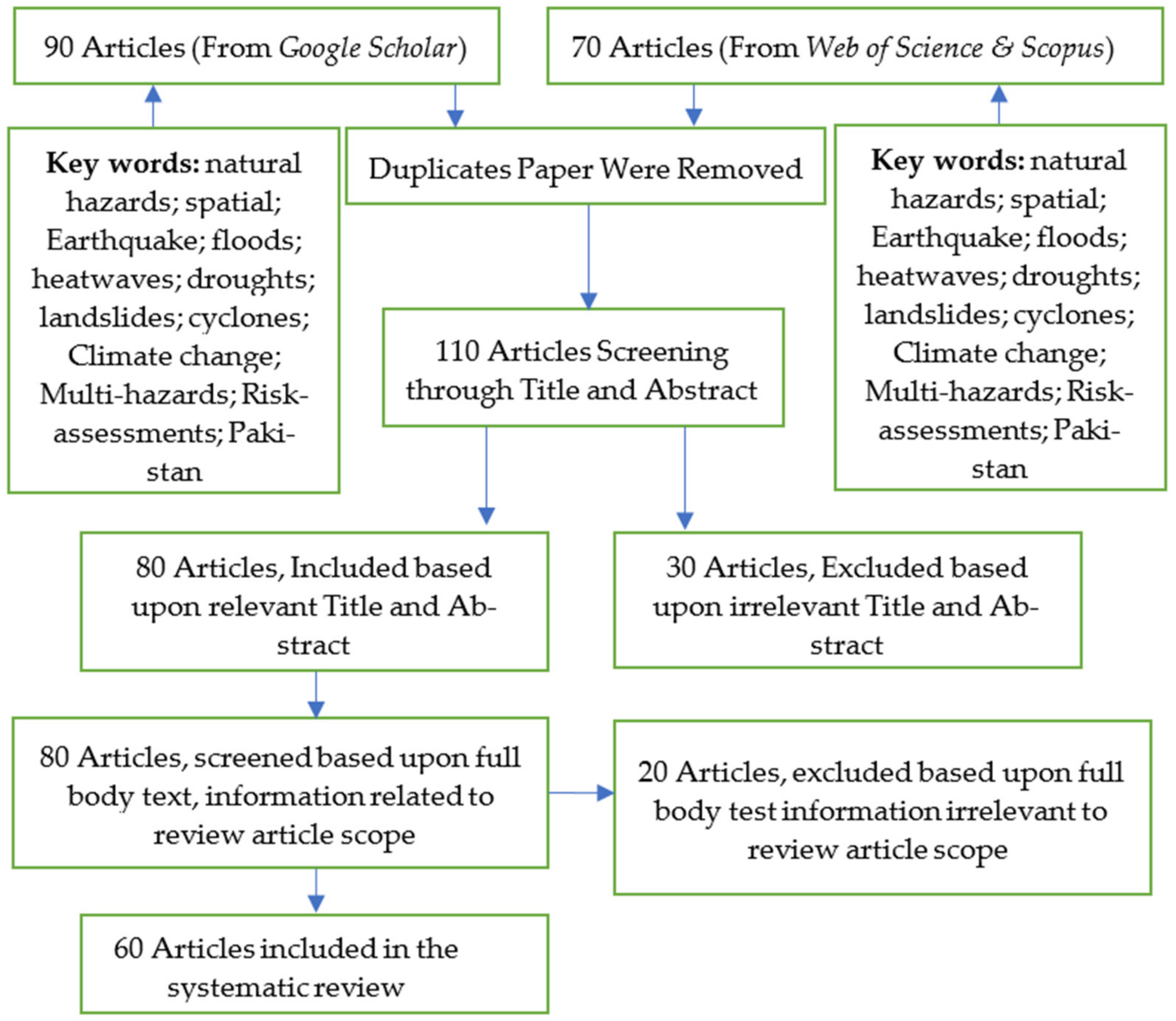
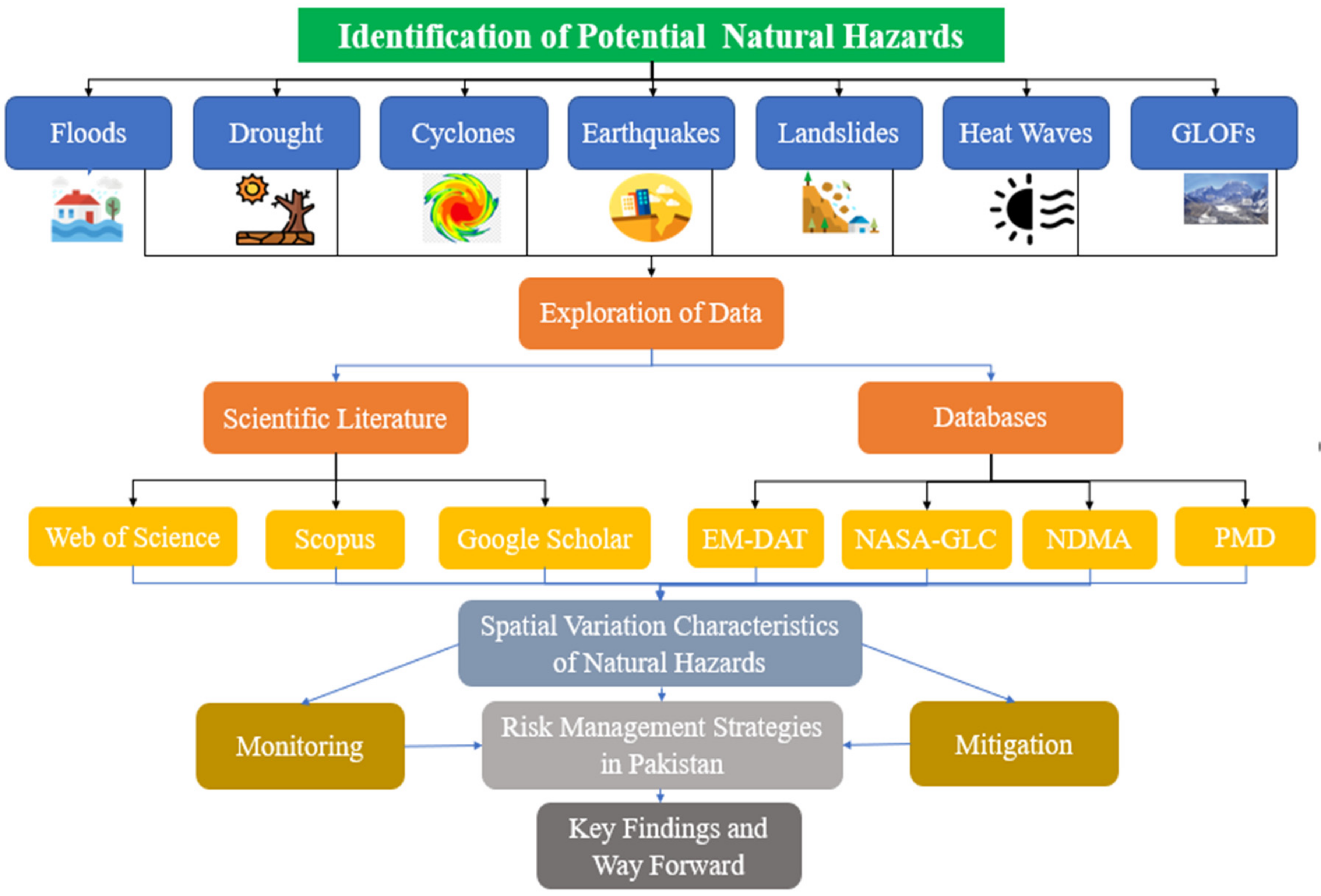
2. Methodology
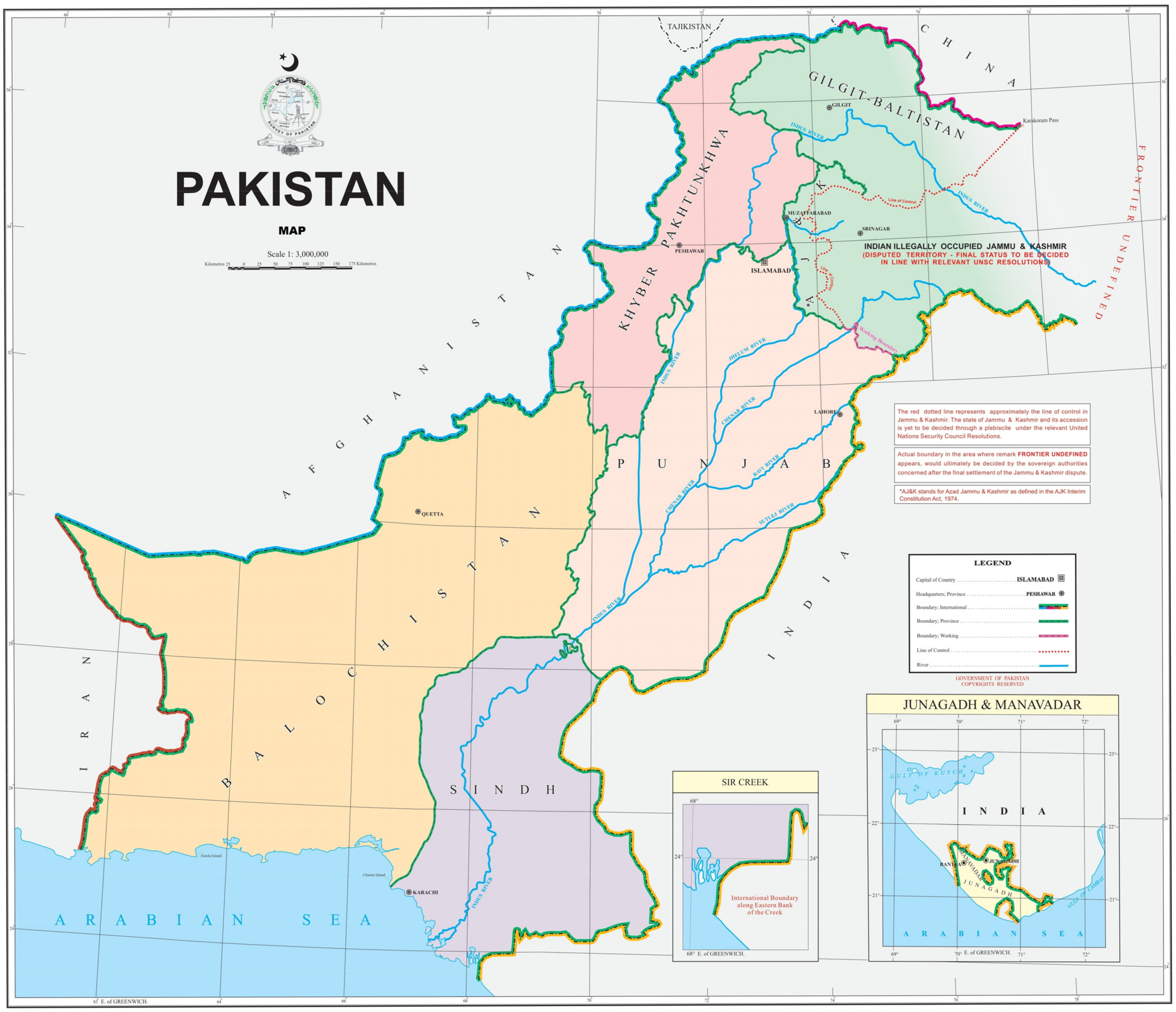
Study Area
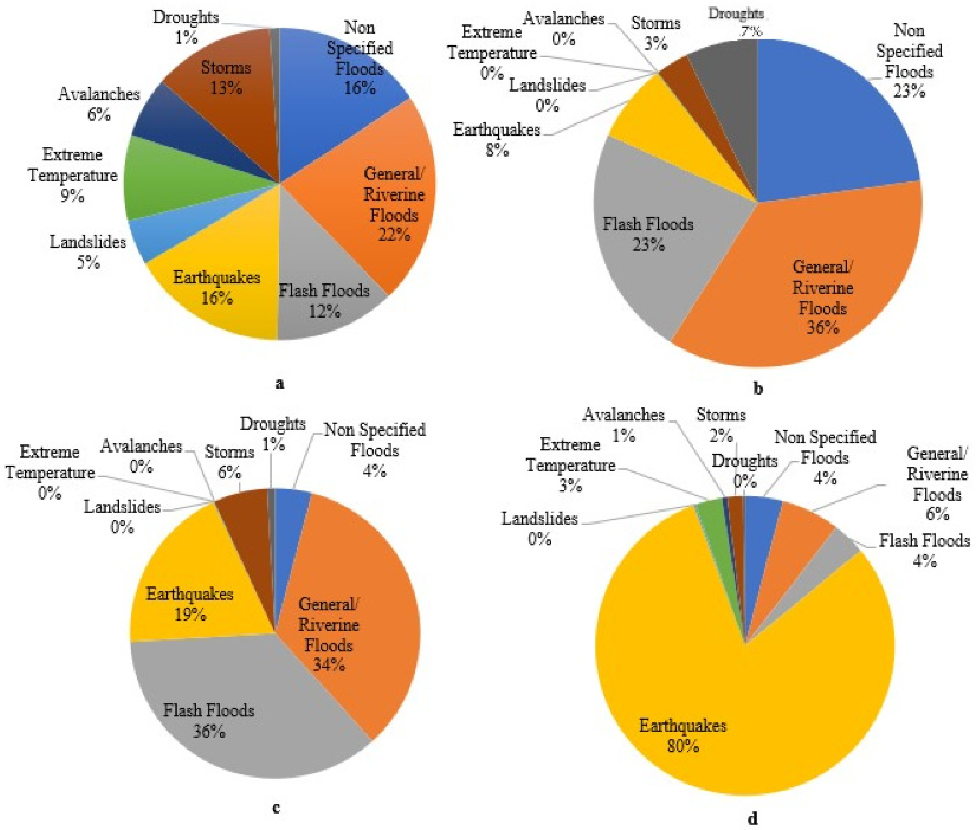
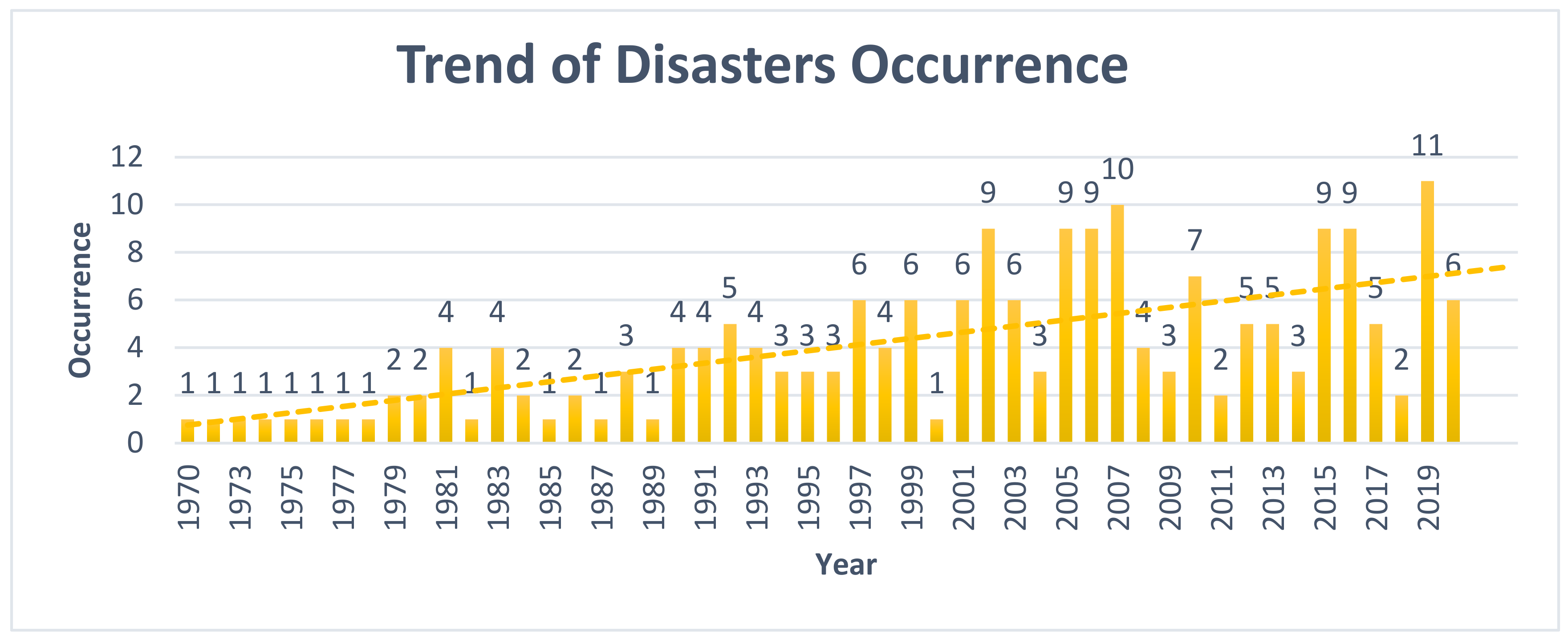
3. Historic Damages Due to Natural Hazards
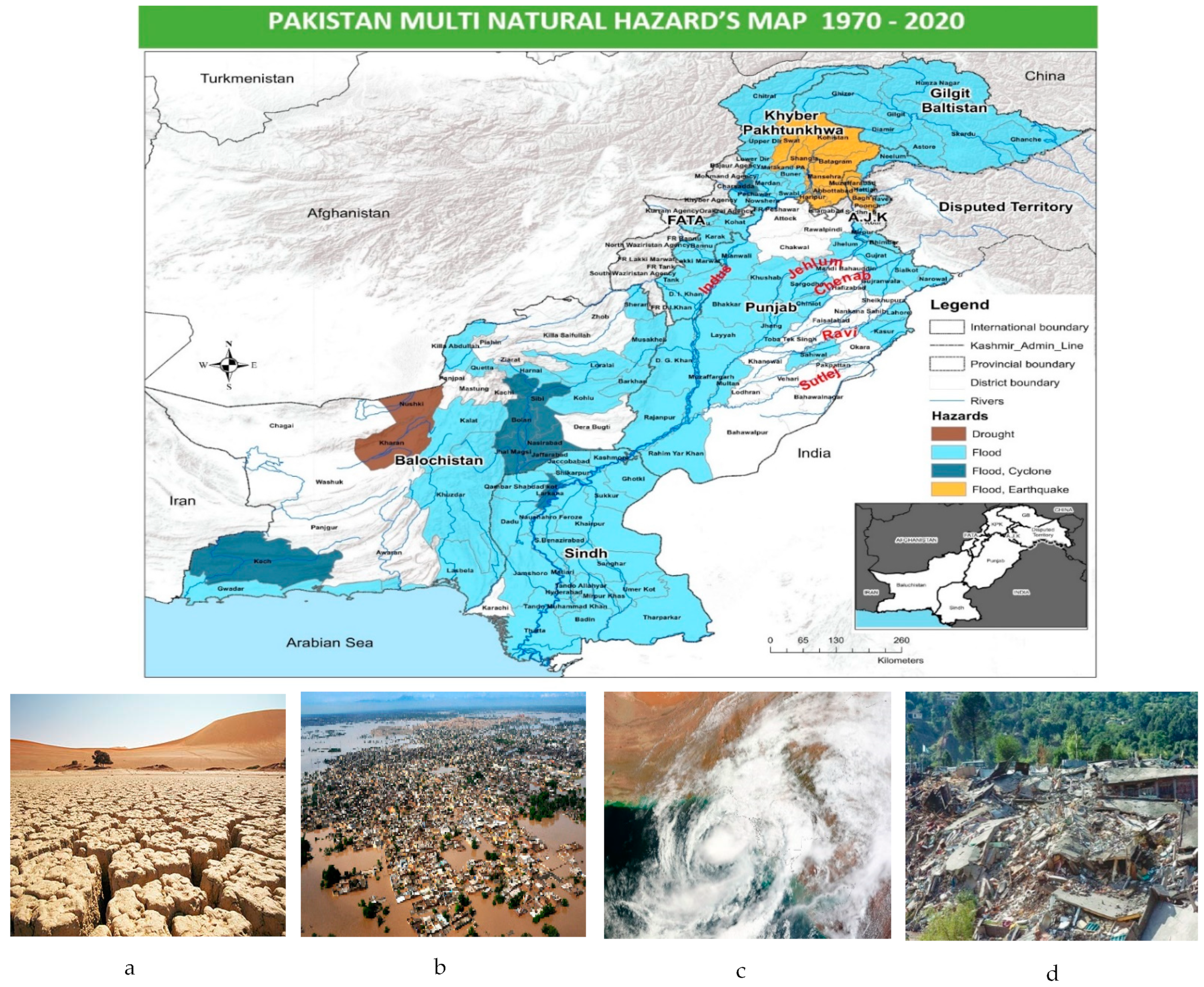
4. Spatial Variations of Natural Hazards in Pakistan
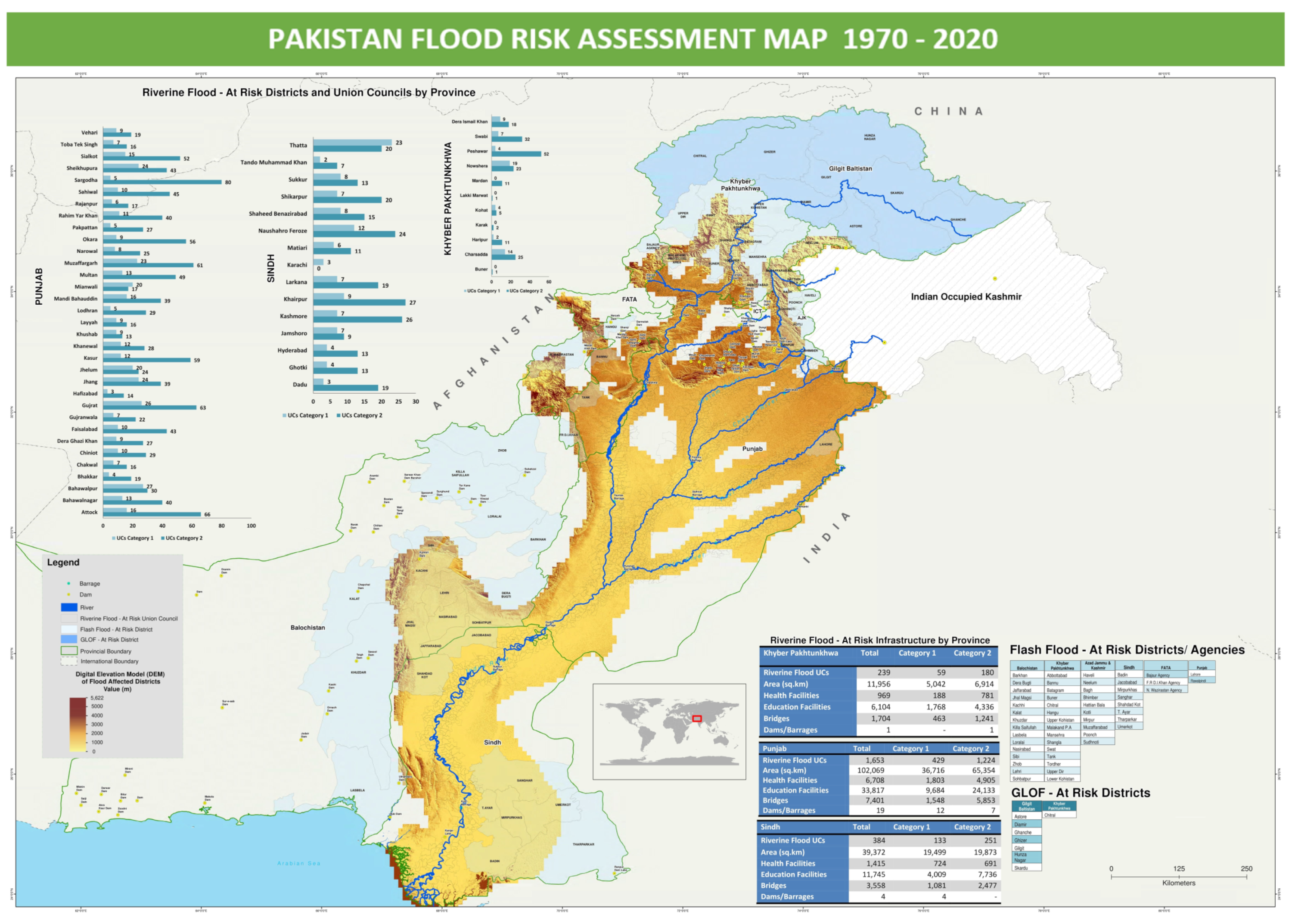
4.1. Floods
4.2. Drought
4.3. Cyclones
4.4. Earthquakes
4.5. Landslide
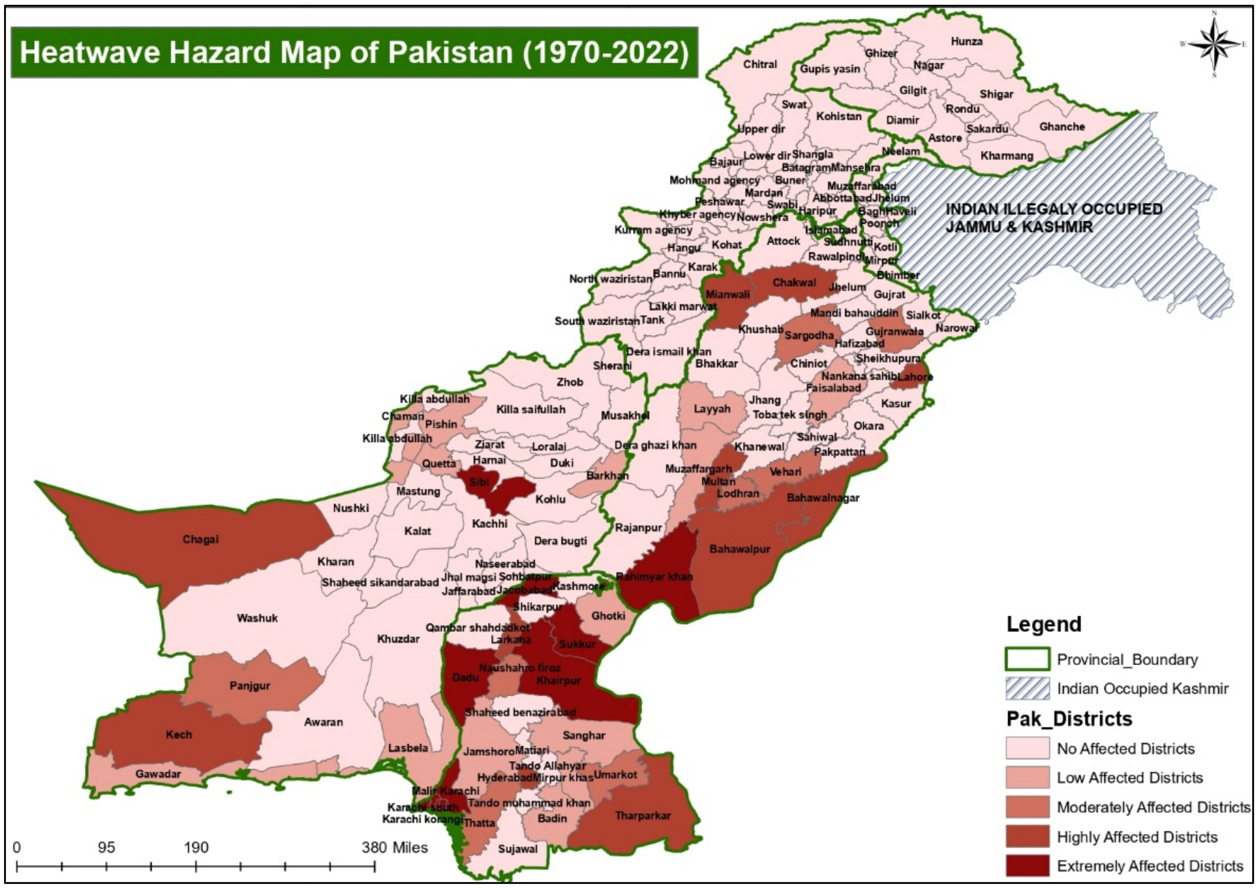
4.6. Heatwave
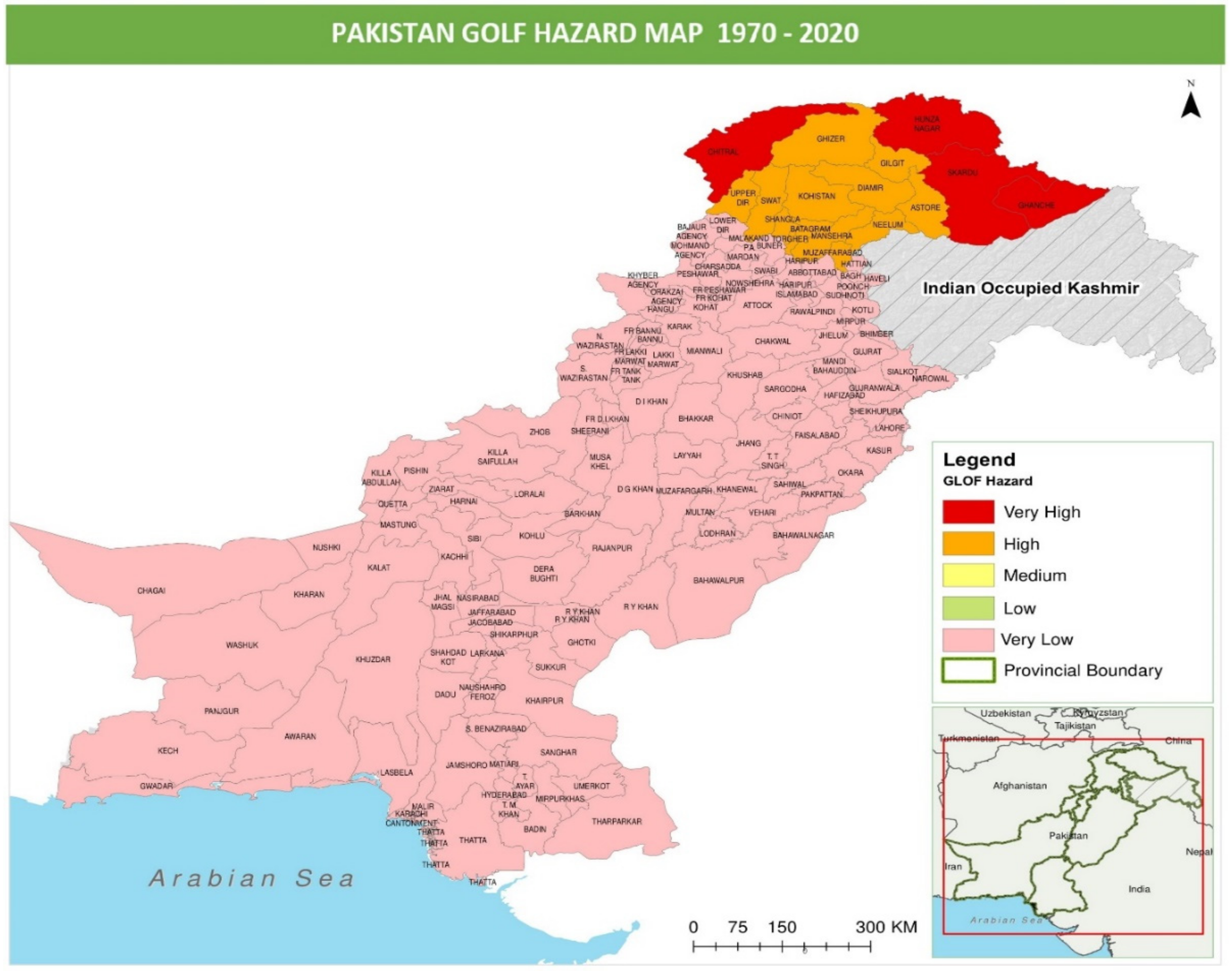
4.7. Glacial Lake Outburst Floods (GLOFs)
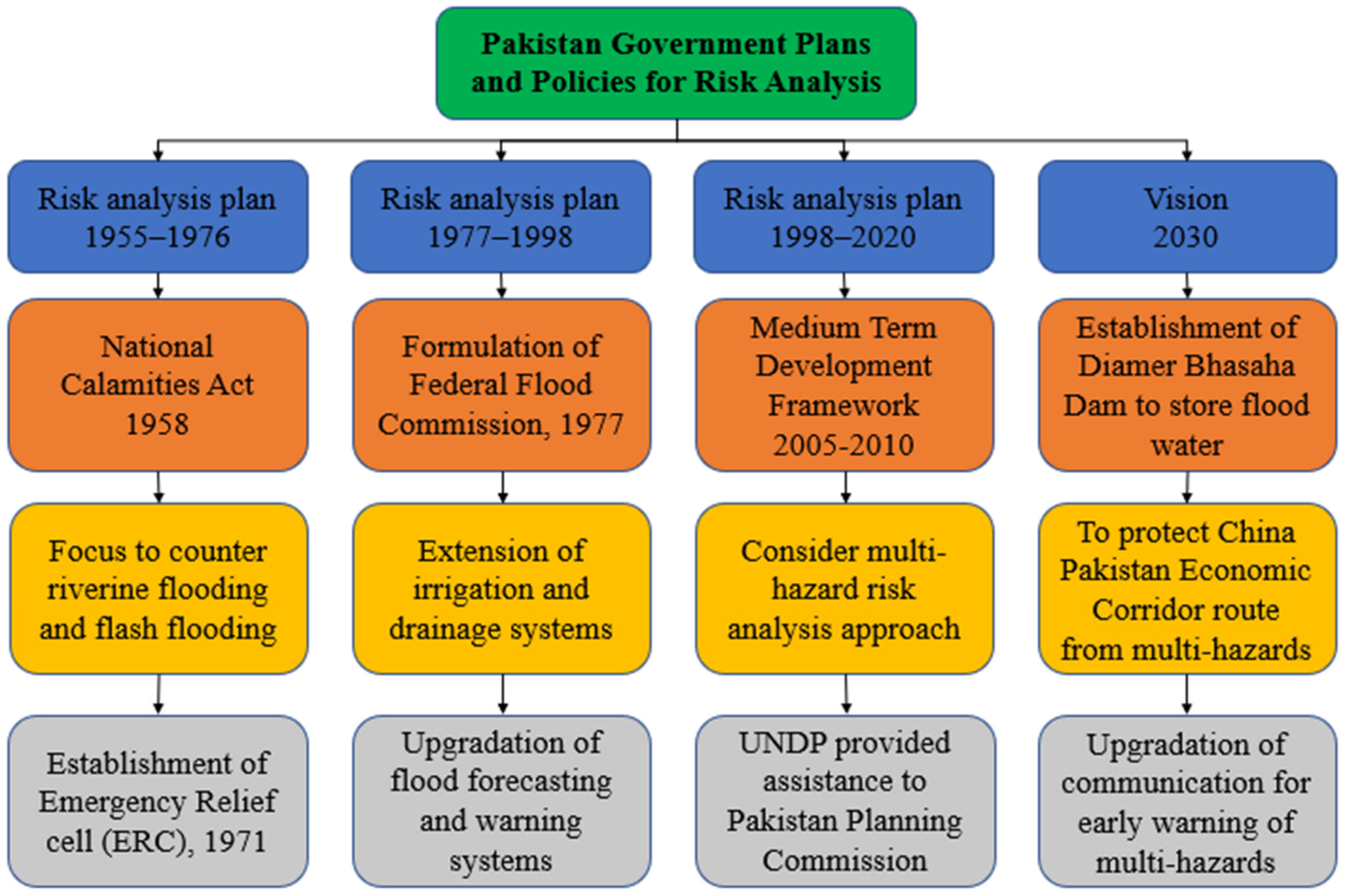
5. Risk Analysis and Management
5.1. Risk Analysis
- Analyses must be carried out in the same research area, at the same geographical scales, and with the same degree of detail; i.e., the base and level of aggregation must be the same; for example, losses may be collected by the city municipality each year;
- The same effects must be assessed, such as direct financial loss to residential buildings, business interruption losses, fatalities, and the impacted people;
- Damage must be represented in the same way, for example, absolute damage in money value, proportional damage in percentages, damage per population, and so forth;
- Risk assessments must be conducted using the same exposures dataset. To evaluate the data results of risk assessments, the anticipated risk indicators, such as risk curves, anticipated yearly damage, etc., must be the same;
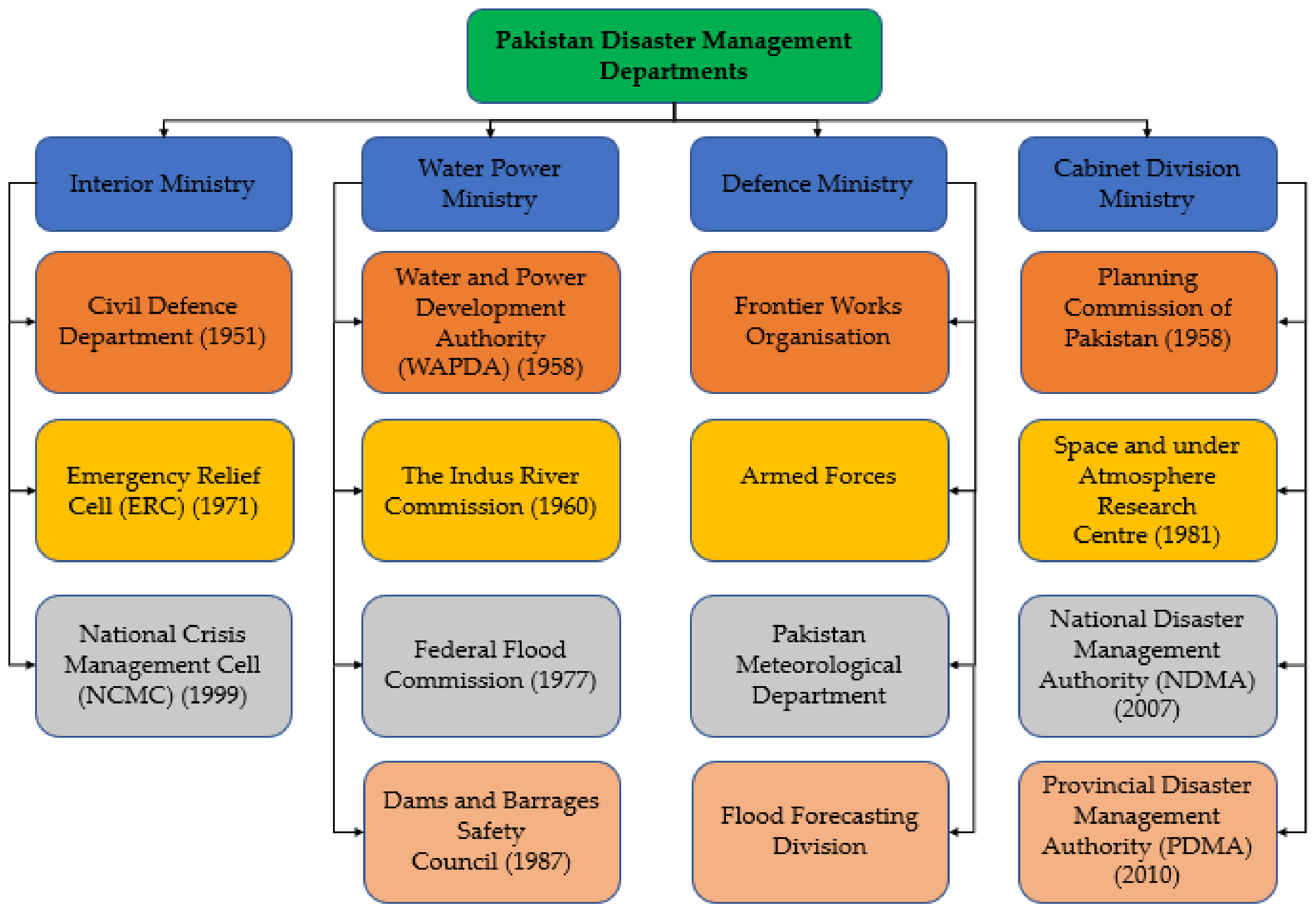
5.2. Risk Management
6. Discussion
7. Conclusions
Author Contributions
Funding
Institutional Review Board Statement
Informed Consent Statement
Data Availability Statement
Acknowledgments
Conflicts of Interest
References
- Lerner-Lam, A. Assessing global exposure to natural hazards: Progress and future trends. Environ. Hazards 2007, 7, 10–19. Available online: https://www.tandfonline.com/doi/abs/10.1016/j.envhaz.2007.04.007 (accessed on 24 May 2021). [CrossRef]
- Linnerooth-Bayer, J.; Hochrainer-Stigler, S. Financial instruments for disaster risk management and climate change adaptation. Clim. Change 2015, 133, 85–100. [Google Scholar] [CrossRef]
- Mirza, M.M.Q. Climate change and extreme weather events: Can developing countries adapt? Clim. Policy 2003, 3, 233–248. [Google Scholar] [CrossRef]
- Eckstein, D.; Hutfils, H.; Winges, M. Global Climate Risk Index 2019; GermanWatch: Bonn, Germany, 2019. [Google Scholar]
- Shah, I.; Elahi, N.; Alam, A.; Dawar, S.; Dogar, A.A. Institutional arrangement for disaster risk management: Evidence from Pakistan. Int. J. Disaster Risk Reduct. 2020, 51, 101784. [Google Scholar] [CrossRef]
- Calligaris, C.; Michele, C.; Shahina, T.; Hawas, K. Attabad landslide on 4th January 2010: A pakistani disaster. In Proceedings of the The Second World Landslide Forum, Rome, Italy, 3–9 October 2011; p. 614. [Google Scholar]
- Hussain, M.; Abeer, N.; Ali, S.; Khan, A.Q.; Kiani, M.H.; Tahir, M.A. Geotechnical aspects of Attabad landslide dam. J. Himal. Earth Sci. 2012, 45, 51. [Google Scholar]
- Petley, D.N.; Rosser, N.J.; Karim, D.; Wali, S.; Ali, N.; Nasab, N.; Shaban, K. Non-seismic landslide hazards along the Himalayan Arc. In Geologically Active; CRC Press: London, UK, 2010; pp. 143–154. [Google Scholar]
- Sökefeld, M. Visualising disaster: Gojal after the Attabad landslide in Northern Pakistan. Tsantsa Z. Schweiz. Ethnol. Ges. 2012, 17, 212–224. [Google Scholar]
- Ahmed, Z. Disaster risks and disaster management policies and practices in Pakistan: A critical analysis of Disaster Management Act 2010 of Pakistan. Int. J. Disaster Risk Reduct. 2013, 4, 15–20. [Google Scholar] [CrossRef]
- Ainuddin, S.; Aldrich, D.P.; Routray, J.K.; Ainuddin, S.; Achkazai, A. The need for local involvement: Decentralization of disaster management institutions in Baluchistan, Pakistan. Int. J. Disaster Risk Reduct. 2013, 6, 50–58. [Google Scholar] [CrossRef]
- Hussain, M.; Arsalan, M.H.; Siddiqi, K.; Naseem, B.; Rabab, U. Emerging geo-information technologies (GIT) for natural disaster management in Pakistan: An overview. In Proceedings of the 2nd International Conference on Recent Advances in Space Technologies RAST 2005, Istanbul, Turkey, 9–11 June 2005; pp. 487–493. [Google Scholar] [CrossRef]
- Early Warning Systems: Supporting Adaptation and Disaster Risk Reduction—WMO/UN Office for Disaster Risk Reduction. 2022. Available online: https://public.wmo.int/en/resources/united_in_science (accessed on 4 September 2022).
- Kron, W. Natural Disasters: Lessons from the Past—Concerns for the Future. Geneva Pap. Risk Insur. Issues Pract. 2000, 25, 570–581. [Google Scholar] [CrossRef]
- Vlachogiannis, D.; Sfetsos, A.; Markantonis, I.; Politi, N.; Karozis, S.; Gounaris, N. Quantifying the Occurrence of Multi-Hazards Due to Climate Change. Appl. Sci. 2022, 12, 1218. [Google Scholar] [CrossRef]
- Hsu, E.L. Must disasters be rapidly occurring? The case for an expanded temporal typology of disasters. Time Soc. 2019, 28, 904–921. [Google Scholar] [CrossRef]
- NDMA. Available online: https://cms.ndma.gov.pk/publications (accessed on 10 October 2022).
- Raza, A.; Kandhro, S.H. National Disaster Management Authority in Pakistan: Role of Pakistan Army in Disaster Management. J. Soc. Adm. Sci. 2015, 2, 1. [Google Scholar] [CrossRef]
- Sheikh, M.M.; Manzoor, N.; Adnan, M. Climate Profile and Past Climate Changes in Pakistan; Global Change Impact Studies Centre (GCISC): Islamabad, Pakistan, 2019. [Google Scholar]
- Goujon, A.; Wazir, A.; Gailey, N. Pakistan: A population giant falling behind in its demographic transition. Popul. Soc. 2020, 576, 1–4. [Google Scholar]
- Pakistan Bureau of Statistics. Brief on Census-2017. Available online: https://www.pbs.gov.pk/content/brief-census-2017 (accessed on 25 September 2021).
- Tatem, A.J. WorldPop, open data for spatial demography. Sci. Data 2017, 4, 170004. [Google Scholar] [CrossRef]
- Survey of Pakistan. Available online: http://www.surveyofpakistan.gov.pk/Detail/MTUzYWU5ZGItNTA4NS00MDlkLWFlODctNTRkY2JmNWI0Mjg2 (accessed on 29 October 2022).
- EMDAT. The OFDA/CRED International Disaster Database; Universite’ Catholique de Louvain: Brussels, Belgium, 2020; Available online: www.emdat.be (accessed on 15 July 2022).
- Manzoor, M.; Bibi, S.; Manzoor, M.; Jabeen, R. Historical Analysis of Flood Information and Impacts Assessment and Associated Response in Pakistan (1947–2011). Res. J. Environ. Earth Sci. 2013, 5, 139–146. [Google Scholar] [CrossRef]
- Frank, N.L. The deadliest tropical cyclone in history? Bull. Am. Meteorol. Soc. 1971, 52, 438–444. [Google Scholar] [CrossRef]
- Sommer, A.; Mosley, W. East Bengal cyclone of November, 1970: Epidemiological approach to disaster assessment. Lancet 1972, 299, 1030–1036. Available online: https://www.sciencedirect.com/science/article/abs/pii/S0140673672912184 (accessed on 25 May 2021). [CrossRef]
- Sarwar, F.; Iqbal, S.; Qaisar, M.; Rehman, A.; Akhtar, F.; Raza, S.M. Earthquake Statistics and Earthquake Research Studies in Pakistan. Open J. Earthq. Res. 2016, 5, 2. [Google Scholar] [CrossRef] [Green Version]
- Hamilton, J.P.; Halvorson, S.J. The 2005 Kashmir Earthquake. Mt. Res. Dev. 2007, 27, 296–301. [Google Scholar] [CrossRef]
- Owen, L.A.; Kamp, U.; Khattak, G.A.; Harp, E.L.; Keefer, D.K.; Bauer, M.A. Landslides triggered by the 8 October 2005 Kashmir earthquake. Geomorphology 2008, 94, 1–9. [Google Scholar] [CrossRef]
- Mulvey, J.M.; Awan, S.U.; Qadri, A.A.; Maqsood, M.A. Profile of injuries arising from the 2005 Kashmir Earthquake: The first 72h. Injury 2008, 39, 554–560. [Google Scholar] [CrossRef]
- Young, N.; Khatak, S.G.; Bengali, K. IASC Inter-Agency Real Time Evaluation of the Pakistan Floods/Cylone Yemyin; Relief Web: New York, NY, USA, 2007; Volume 31. [Google Scholar]
- Butt, M.J.; Umar, M.; Qamar, R. Landslide dam and subsequent dam-break flood estimation using HEC-RAS model in Northern Pakistan. Nat. Hazards 2013, 65, 241–254. [Google Scholar] [CrossRef]
- Gardezi, H.; Bilal, M.; Cheng, Q.; Xing, A.; Zhuang, Y.; Masood, T. A comparative analysis of attabad landslide on january 4, 2010, using two numerical models. Nat. Hazards 2021, 107, 519–538. [Google Scholar] [CrossRef]
- Sökefeld, M. The Attabad landslide and the politics of disaster in Gojal, Gilgit-Baltistan. In Negotiating Disasters: Politics, Representation, Meanings; Peter Lang: Berlin, Germany, 2012; p. 31. [Google Scholar]
- Hashmi, H.N.; Siddiqui, Q.T.M.; Ghumman, A.R.; Kamal, M.A.; Mughal, H.R. A critical analysis of 2010 floods in Pakistan. Afr. J. Agric. Res. 2012, 7, 1054–1067. [Google Scholar] [CrossRef] [Green Version]
- Looney, R. Economic impacts of the floods in Pakistan. Contemp. South Asia 2012, 20, 225–241. Available online: https://www.tandfonline.com/doi/abs/10.1080/09584935.2012.670203 (accessed on 25 May 2021). [CrossRef]
- Warriach, H.; Zaidi, A.K.; Patel, K. Floods in Pakistan: A public health crisis. Bull. World Health Organ. 2011, 89, 236–237. Available online: https://www.scielosp.org/article/bwho/2011.v89n3/236-237/en/ (accessed on 25 May 2021). [CrossRef] [PubMed]
- Ahmad, J.; Ahmad, M.M.; Ahmad, N. Natural disasters and public health in the era of Sustainable Development Goals: A retrospective study of the October 2015 Hindu Kush earthquake in Pakistan. Procedia Eng. 2018, 212, 855–862. [Google Scholar] [CrossRef]
- Naseer, S.; Haq, T.U.; Khan, A.; Tanoli, J.I.; Khan, N.G.; Shah, S.T.H. GIS-based spatial landslide distribution analysis of district Neelum, AJ&K, Pakistan. Nat. Hazards 2021, 106, 965–989. [Google Scholar]
- NDMA Report. 2018. Available online: https://cms.ndma.gov.pk/storage/app/public/publications/September2022/ZyBmIrEtYr5bAlvnlES8.pdf (accessed on 25 May 2021).
- Ullah, W.; Takaaki, N. Climate change vulnerability of Pakistan towards natural disasters: A review. Int. J. Environ. Prot. Policy 2016, 4, 126. [Google Scholar] [CrossRef] [Green Version]
- Fontaine, B.; Janicot, S.; Monerie, P.-A. Recent changes in air temperature, heat waves occurrences, and atmospheric circulation in Northern Africa. J. Geophys. Res. Atmos. 2013, 118, 8536–8552. [Google Scholar] [CrossRef]
- Friedlingstein, P.; Solomon, S.; Plattner, G.K.; Knutti, R.; Ciais, P.; Raupach, M.R. Long-term climate implications of twenty-first century options for carbon dioxide emission mitigation. Nat. Clim. Change 2011, 1, 457–461. [Google Scholar] [CrossRef]
- Solomon, S.; Plattner, G.-K.; Knutti, R.; Friedlingstein, P. Irreversible climate change due to carbon dioxide emissions. Proc. Natl. Acad. Sci. USA 2009, 106, 1704–1709. [Google Scholar] [CrossRef] [PubMed] [Green Version]
- Kronstadt, K.A. Flooding in Pakistan: Overview and Issues for Congress; Congressional Research Service: Washington, DC, USA, 2010. [Google Scholar]
- Nawaz, U.; Shahid, S.; Ahmad, R.; Ibrahim, M.U.; Wajid, A.; Manan, A.; Qureshi, M.I. Indus Basin Irrigation System and climatic trends regarding glacial regimes and water runoff. J. Environ. J. Agric. Sci. 2016, 9, 28–36. [Google Scholar]
- Ashraf, A.; Naz, R.; Roohi, R. Glacial lake outburst flood hazards in Hindukush, Karakoram and Himalayan Ranges of Pakistan: Implications and risk analysis. Geomat. Nat. Hazards Risk 2012, 3, 113–132. [Google Scholar] [CrossRef]
- Gilany, N.; Iqbal, J. Geospatial analysis and simulation of glacial lake outburst flood hazard in Shyok Basin of Pakistan. Environ. Earth Sci. 2020, 79, 139. [Google Scholar] [CrossRef]
- Ahmad, F.; Kazmi, S.F.; Pervez, T. Human response to hydro-meteorological disasters: A case study of the 2010 flash floods in Pakistan. J. Geogr. Reg. Plan. 2011, 4, 518–524. [Google Scholar]
- Webster, P.J.; Toma, V.E.; Kim, H.-M. Were the 2010 Pakistan floods predictable? Geophys. Res. Lett. 2011, 38, L04806. [Google Scholar] [CrossRef]
- Siddiqi, A. The Emerging Social Contract: State-Citizen Interaction after the Floods of 2010 and 2011 in Southern Sindh, Pakistan. IDS Bull. 2013, 44, 94–102. [Google Scholar] [CrossRef] [Green Version]
- Wasim, M.A. The landscape of disaster management in Pakistan: Gaps in the legal framework. In Disaster Law; Routledge: Abingdon-on-Thames, UK, 2017; pp. 65–179. [Google Scholar]
- Pakistan: Flood Extend (16 September 2010) and Flood Losses (13 October 2010). Available online: https://reliefweb.int/map/pakistan/pakistan-flood-extend-16-sept-2010-and-flood-losses-13-oct-2010 (accessed on 29 October 2022).
- Campbell, J.G.; Pradesh, H. Inventory of Glaciers, Glacial Lakes and the Identification of Potential Glacial Lake Outburst Floods (GLOFs) Affected by Global Warming in the Mountains of India, Pakistan and China/Tibet Autonomous Region; International Centre for Integrated Mountain Development: Kathmandu, Nepal, 2005. [Google Scholar]
- Ghaffar, A.; Javid, M. Impact of global warming on monsoon variability in Pakistan. J. Anim. Plant Sci. 2011, 21, 107–110. [Google Scholar]
- Anjum, S.A.; Saleem, M.F.; Cheema, M.A.; Bilal, M.F.; Khaliq, T. An assessment to vulnerability, extent, characteristics and severity of drought hazard in Pakistan. Pak. J. Sci. 2012, 64, 138. [Google Scholar]
- Siddiqui, S.; Safi, M.W.A. Assessing the socio-economic and environmental impacts of 2014 drought in District Tharparkar, Sindh-Pakistan. Int. J. Econ. Environ. Geol. 2019, 8, 15. [Google Scholar]
- Ashraf, M.; Routray, J.K. Spatio-temporal characteristics of precipitation and drought in Balochistan Province, Pakistan. Nat. Hazards 2015, 77, 229–254. [Google Scholar] [CrossRef]
- Bilal, M.; Liaqat, M.U.; Cheema, M.J.M.; Mahmood, T.; Khan, Q. Spatial drought monitoring in Thar desert using satellite-based drought indices and geo-informatics techniques. Proceedings 2018, 2, 179. [Google Scholar]
- Zaigham, N.A. Strategic Sustainable Development of Groundwater in Thar Desert of Pakistan. Water Resour. South Present Scenar. Future Prospect. 2003, 56, 61–74. [Google Scholar]
- Ahmed, K.; Shahid, S.; Harun, S.; Wang, X. Characterization of seasonal droughts in Balochistan Province, Pakistan. Stoch. Environ. Res. Risk Assess. 2016, 30, 747–762. [Google Scholar] [CrossRef]
- Sarwar, A. Droughts in Pakistan—A socio-political perspective. In Droughts and Integrated Water Resource Management in South Asia: Issues, Alternatives and Futures; SAGE Publications: New Delhi, India, 2008; pp. 200–230. [Google Scholar]
- TORRES, C.A.-Q. Drought in Tharparkar: From seasonal to forced migration. State Environ. Migr. 2015, 19, 64. [Google Scholar]
- Babar, H. Detailed history of Cyclones in Pakistan. 2011. Available online: https://pakistanweatherportal.com/2011/03/31/history-of-cyclones-in-pakistan/ (accessed on 25 September 2021).
- Kidwai, S.; Ahmed, W.; Tabrez, S.M.; Zhang, J.; Giosan, L.; Clift, P.; Inam, A. The Indus delta—Catchment, river, coast, and people. In Coasts and Estuaries; Elsevier: Amsterdam, The Netherlands, 2019; pp. 213–232. [Google Scholar]
- WDR. 2003. Available online: https://www.google.com/search?q=world+disaster+report+2003&sxsrf=ALeKk02pnT7BVVfqnMsicJ2t99qG7nToWw%3A1625982325395&ei=dYXqYMvBF-yAjLsPy-Kn4Ao&oq=world+disaster+report+2003&gs_lcp=Cgdnd3Mtd2l6EAMyBQghEKABOgQIIxAnOgUIABCRAjoKCAAQsQMQgwEQQzoICAAQsQMQgwE6BQgAELEDOggIABCxAxCRAjoECAAQQzoECC4QQzoHCAAQsQMQQzoCCAA6AgguOgUILhCTAjoGCAAQFhAeOggIABAWEAoQHkoECEEYAFDbEliBVWCjV2gAcAJ4AIAB4AOIAdc7kgEIMi0yMi4zLjKYAQCgAQGqAQdnd3Mtd2l6wAEB&sclient=gws-wiz&ved=0ahUKEwiL0KmXqNrxAhVsAGMBHUvxCawQ4dUDCA4&uact=5 (accessed on 11 July 2021).
- Hanks, T.C. Earthquake stress drops, ambient tectonic stresses and stresses that drive plate motions. In Stress in the Earth; Springer: Basel, Switzerland, 1977; pp. 441–458. [Google Scholar]
- McKenzie, D.; Jackson, J. Tsunami earthquake generation by the release of gravitational potential energy. Earth Planet. Sci. Lett. 2012, 345, 1–8. [Google Scholar] [CrossRef]
- Bernard, M.; Shen-Tu, B.; Holt, W.E.; Davis, D.M. Kinematics of active deformation in the Sulaiman Lobe and Range, Pakistan. J. Geophys. Res. Solid Earth 2000, 105, 13253–13279. [Google Scholar] [CrossRef]
- Sultan, M. Seismic hazard analysis of Pakistan. J. Geol. Geosci. 2015, 4, 190. [Google Scholar]
- Searle, M.P.; Robb, L.J.; Gardiner, N.J. Tectonic Processes and Metallogeny along the Tethyan Mountain Ranges of the Middle East and South Asia (Oman, Himalaya, Karakoram, Tibet, Myanmar, Thailand, Malaysia). J. Geol. Geosci. 2016, 19, 301–327. [Google Scholar]
- Bothara, J.K.; Hiçyılmaz, K.M. General observations of building behaviour during the 8th October 2005 Pakistan earthquake. Bull. N. Z. Soc. Earthq. Eng. 2008, 41, 209–233. [Google Scholar]
- Mahmood, I.; Kidwai, A.A.; Qureshi, S.N.; Iqbal, M.F.; Atique, L. Revisiting major earthquakes in Pakistan. Geol. Today 2015, 31, 33–38. [Google Scholar] [CrossRef]
- Buttenheim, A. Impact evaluation in the post-disaster setting: A case study of the 2005 Pakistan earthquake. J. Dev. Eff. 2010, 2, 197–227. [Google Scholar] [CrossRef]
- Ali, S.M.; Khan, A.N.; Rahman, S.; Reinhorn, A.M. A survey of damages to bridges in Pakistan after the major earthquake of 8 October 2005. Earthq. Spectra 2011, 27, 947–970. [Google Scholar] [CrossRef]
- Maqsood, S.T.; Schwarz, J. Building Vulnerability and Damage during the 2008 Baluchistan Earthquake in Pakistan and Past Experiences. Seismol. Res. Lett. 2010, 81, 514–525. [Google Scholar] [CrossRef]
- Rehman, S.U.; Azeem, T.; El-Aal, A.E.-A.K.A.; Nasir, A. Parameterization of 18th January 2011 earthquake in Dalbadin Region, Southwest Pakistan. NRIAG J. Astron. Geophys. 2013, 2, 203–211. [Google Scholar] [CrossRef] [Green Version]
- Vallage, A.; Klinger, Y.; Lacassin, R.; Delorme, A.; Pierrot-Deseilligny, M. Geological structures control on earthquake ruptures: The Mw7.7, 2013, Balochistan earthquake, Pakistan. Geophys. Res. Lett. 2016, 43, 10155–10163. [Google Scholar] [CrossRef] [Green Version]
- Ahmed, J.; Shah, M.; Zafar, W.A.; Amin, M.A.; Iqbal, T. Seismoionospheric anomalies associated with earthquakes from the analysis of the ionosonde data. J. Atmos. Sol. Terr. Phys. 2018, 179, 450–458. [Google Scholar] [CrossRef]
- Khan, M.Y.; Turab, S.A.; Riaz, M.S.; Atekwana, E.A.; Muhammad, S.; Butt, N.A.; Abbas, S.M.; Zafar, W.A.; Ohenhen, L.O. Investigation of coseismic liquefaction-induced ground deformation associated with the 2019 Mw 5.8 Mirpur, Pakistan, earthquake using near-surface electrical resistivity tomography and geological data. Near Surf. Geophys. 2021, 19, 169–182. [Google Scholar] [CrossRef]
- Hungr, O. Dynamics of rapid landslides. In Progress in Landslide Science; Springer: Berlin/Heidelberg, Germany, 2007; pp. 47–57. [Google Scholar]
- Causes, L. Landslide Types and Processes; U.S. Geological Survey: Reston, VA, USA, 2001. [Google Scholar]
- Owen, L.A.; England, J. Observations on rock glaciers in the Himalayas and Karakoram Mountains of northern Pakistan and India. Geomorphology 1998, 26, 199–213. [Google Scholar] [CrossRef] [Green Version]
- Chen, X.; Cui, P.; You, Y.; Cheng, Z.; Khan, A.; Ye, C.; Zhang, S. Dam-break risk analysis of the Attabad landslide dam in Pakistan and emergency countermeasures. Landslides 2017, 14, 675–683. [Google Scholar] [CrossRef]
- Duncan, J.M.; Wright, S.G. The accuracy of equilibrium methods of slope stability analysis. Eng. Geol. 1980, 16, 5–17. [Google Scholar] [CrossRef]
- Fredlund, D.G.; Krahn, J. Comparison of slope stability methods of analysis. Can. Geotech. J. 1977, 14, 429–439. [Google Scholar] [CrossRef]
- Hovland, H.J. Three-dimensional slope stability analysis method. J. Geotech. Eng. Div. 1977, 103, 971–986. [Google Scholar] [CrossRef]
- Kliche, C.A. Rock Slope Stability; Society for Mining, Metallurgy, and Exploration: Englewood, CO, USA, 1999. [Google Scholar]
- Moawwez, M.A.; Wang, J.-P.; Hussain, M.A. Development of empirical correlations for limit equilibrium methods of slope stability analysis. Arab. J. Geosci. 2021, 14, 2020. [Google Scholar] [CrossRef]
- Hewitt, K. Catastrophic landslides and their effects on the Upper Indus streams, Karakoram Himalaya, northern Pakistan. Geomorphology 1998, 26, 47–80. [Google Scholar] [CrossRef]
- Ahmed, K.A.; Khan, S.; Sultan, M.; Nisar, U.B.; Mughal, M.R.; Qureshi, S.N. Landslides assessment using geophysical and passive radon exhalation detection techniques in Murree Hills, northern Pakistan: Implication for environmental hazard assessment. J. Earth Syst. Sci. 2020, 129, 53. [Google Scholar] [CrossRef]
- Rahman, A.; Khan, A.N.; Collins, A.E. Analysis of landslide causes and associated damages in the Kashmir Himalayas of Pakistan. Nat. Hazards 2014, 71, 803–821. [Google Scholar] [CrossRef]
- Xu, Z.; FitzGerald, G.; Guo, Y.; Jalaludin, B.; Tong, S. Impact of heatwave on mortality under different heatwave definitions: A systematic review and meta-analysis. Environ. Int. 2016, 89, 193–203. [Google Scholar] [CrossRef]
- Zahid, M.; Rasul, G. Changing trends of thermal extremes in Pakistan. Clim. Change 2012, 113, 883–896. [Google Scholar] [CrossRef]
- Khan, N.; Shahid, S.; Ismail, T.; Ahmed, K.; Nawaz, N. Trends in heat wave related indices in Pakistan. Stoch. Environ. Res. Risk Assess. 2019, 33, 287–302. [Google Scholar] [CrossRef]
- Zahid, M.; Rasul, G. Rise in summer heat index over Pakistan. Pak. J. Meteorol. 2010, 6, 85–96. [Google Scholar]
- Russo, S.; Sillmann, J.; Sterl, A. Humid heat waves at different warming levels. Sci. Rep. 2017, 7, 7477. [Google Scholar] [CrossRef] [PubMed] [Green Version]
- MBaig, A.; Waheed, S.; Mian, A.; Hussain, E. Unforgiving heat wave deaths in the largest metropolitan city of Pakistan: Lessons learned. Eurasian J. Emerg. Med. 2015, 14, 209. [Google Scholar]
- Masood, I.; Majid, Z.; Sohail, S.; Zia, A.; Raza, S. The deadly heat wave of Pakistan, June 2015. Int. J. Occup. Environ. Med. 2015, 6, 247. [Google Scholar] [CrossRef] [PubMed] [Green Version]
- Salim, A.; Ahmed, A.; Ashraf, N.; Ashar, M. Deadly Heat Wavein Karachi, July 2015: Negligence or Mismanagement? Int. J. Occup. Environ. Med. 2015, 6, 249. [Google Scholar] [CrossRef]
- Wehner, M.; Stone, D.; Krishnan, H.; AchutaRao, K. Castillo The deadly combination of heat and humidity in India and Pakistan in summer 2015. Bull. Am. Meteorol. Soc. 2016, 97, S81–S86. [Google Scholar] [CrossRef] [Green Version]
- Veh, G.; Korup, O.; von Specht, S.; Roessner, S.; Walz, A. Unchanged frequency of moraine-dammed glacial lake outburst floods in the Himalaya. Nat. Clim. Change 2019, 9, 379–383. [Google Scholar] [CrossRef]
- Bazai, N.A.; Cui, P.; Carling, P.A.; Wang, H.; Hassan, J.; Liu, D.; Zhang, G.; Jin, W. Increasing glacial lake outburst flood hazard in response to surge glaciers in the Karakoram. Earth-Sci. Rev. 2020, 212, 103432. [Google Scholar] [CrossRef]
- Rehman, G. GLOF Risk and Reduction Approaches in Pakistan. In Disaster Risk Reduction Approaches in Pakistan; Springer: Tokyo, Japan, 2015; pp. 217–237. [Google Scholar]
- Uddin, N.; Anjum, M.; Uddin, S.; Uddin, Z. Debris flow hazard of glacial lake in Chitral, Pakistan. In Proceedings of the 6th Conference Debris Flows: Disasters, Risk, Forecast, Protection, Dushanbe–Khorog, Tajikistan, 6–10 September 2020. [Google Scholar]
- Hill, L.J.; Sparks, R.S.J.; Rougier, J.C. Risk assessment and uncertainty in natural hazards. In Risk and Uncertainty Assessment for Natural Hazards; Cambridge University Press: Cambridge, UK, 2013; pp. 1–18. [Google Scholar]
- Burton, I.; Kates, R.W. The perception of natural hazards in resource management. Nat. Resour. J. 1963, 3, 412. [Google Scholar]
- Kunreuther, H. Mitigation and financial risk management for natural hazards. Geneva Pap. Risk Insur. Issues Pract. 2001, 26, 277–296. [Google Scholar] [CrossRef]
- Pitilakis, K.; Argyroudis, S.; Kakderi, K.; Selva, J. Systemic vulnerability and risk assessment of transportation systems under natural hazards towards more resilient and robust infrastructures. Transp. Res. Procedia 2016, 14, 1335–1344. [Google Scholar] [CrossRef] [Green Version]
- Shah, S.M.A. Pakistan National Disaster Management Act–2010 An Analytical Study. Ph.D. Thesis, Federal Urdu University of Arts, Karachi, Pakistan, 2010. [Google Scholar]
- Shaw, R. Hazard, vulnerability and risk: The Pakistan context. In Disaster Risk Reduction Approaches in Pakistan; Springer: Tokyo, Japan, 2015; pp. 31–52. [Google Scholar]
- Bibi, T.; Nawaz, F.; Rahman, A.A.; Razak, K.A.; Latif, A. Flood Risk Assessment of River Kabul and Swat Catchment Area: District Charsadda, Pakistan. Int. Arch. Photogramm. Remote Sens. Spat. Inf. Sci. 2018, 42, 105–113. [Google Scholar] [CrossRef] [Green Version]
- Larsen, O.; Oliver, J.; Lanuza, E.C. Developing a Disaster Risk Insurance Framework for Vulnerable Communities in Pakistan: Pakistan Disaster Risk Profile; United Nations University Institute for Environment and Human Security (UNU-EHS): Bonn, Germany, 2014. [Google Scholar]
- Rana, I.A.; Routray, J.K. Integrated methodology for flood risk assessment and application in urban communities of Pakistan. Nat. Hazards 2018, 91, 239–266. [Google Scholar] [CrossRef]
- Van Westen, C.J. Remote sensing and GIS for natural hazards assessment and disaster risk management. Treatise Geomorphol. 2013, 3, 259–298. [Google Scholar]
- Guikema, S. Artificial intelligence for natural hazards risk analysis: Potential, challenges, and research needs. Risk Anal. 2020, 40, 1117–1123. [Google Scholar] [CrossRef]
- Plapp, T.; Werner, U. Understanding risk perception from natural hazards: Examples from Germany. In RISK21-Coping with Risks Due to Natural Hazards in the 21st Century; CRC Press: London, UK, 2006; pp. 111–118. [Google Scholar]
- Wachinger, G.; Renn, O.; Begg, C.; Kuhlicke, C. The risk perception paradox—Implications for governance and communication of natural hazards. Risk Anal. 2013, 33, 1049–1065. [Google Scholar] [CrossRef]
- Zlateva, P.; Velev, D. Complex risk analysis of natural hazards through fuzzy logic. J. Adv. Manag. Sci. 2013, 1, 395–400. [Google Scholar] [CrossRef]
- Raoof, R.; Rasool, R.; Sattar, J.; Shami, U.T.; Murtaza, G.; Ashraf, M.; Ali, Q.; Malik, A. Evaluation of disaster risk management structure of pakistan with emphasis on man-made disaster. PalArch’s J. Archaeol. Egypt/Egyptol. 2021, 18, 1281–1294. [Google Scholar]
- Shaw, R. Introduction and approaches of disaster risk reduction in Pakistan. In Disaster Risk Reduction Approaches in Pakistan; Springer: Tokyo, Japan, 2015; pp. 3–29. [Google Scholar]
- Carpignano, A.; Golia, E.; Di Mauro, C.; Bouchon, S.; Nordvik, J.-P. A methodological approach for the definition of multi-risk maps at regional level: First application. J. Risk Res. 2009, 12, 513–534. [Google Scholar] [CrossRef]
- Liu, Z.; Nadim, F.; Garcia-Aristizabal, A.; Mignan, A.; Fleming, K.; Luna, B.Q. A three-level framework for multi-risk assessment. Georisk Assess. Manag. Risk Eng. Syst. Geohazards 2015, 9, 59–74. [Google Scholar] [CrossRef] [Green Version]
- Schmidt, J.; Matcham, I.; Reese, S.; King, A.; Bell, R.; Henderson, R.; Smart, G.; Cousins, J.; Smith, W.; Heron, D. Quantitative multi-risk analysis for natural hazards: A framework for multi-risk modelling. Nat. Hazards 2011, 58, 1169–1192. [Google Scholar] [CrossRef]
- Zlatanova, S.; Holweg, D.; Stratakis, M. Framework for multi-risk emergency response. In Advances in Mobile Mapping Technology; CRC Press: London, UK, 2007; pp. 175–188. [Google Scholar]
- Clemen, R.T.; Winkler, R.L. Combining probability distributions from experts in risk analysis. Risk Anal. 1999, 19, 187–203. [Google Scholar] [CrossRef]
- Salik, K.M.; Hashmi, M.Z.-R.; Ishfaq, S. Environmental flow requirements and impacts of climate change-induced river flow changes on ecology of the Indus Delta, Pakistan. Reg. Stud. Mar. Sci. 2016, 7, 185–195. [Google Scholar] [CrossRef]
- Qureshi, A.S.; McCornick, P.G.; Sarwar, A.; Sharma, B.R. Challenges and prospects of sustainable groundwater management in the Indus Basin, Pakistan. Water Resour. Manag. 2010, 24, 1551–1569. [Google Scholar] [CrossRef] [Green Version]
- Khalid, P.D.I.; Khan, M.A. Water Scarcity-A Major Human Security Challenge to Pakistan. South Asian Stud. 2020, 31, 3066. [Google Scholar]
- Maddocks, A.; Young, R.S.; Reig, P. Ranking the World’s Most Water-Stressed Countries in 2040. World Resources Institute. 2015. Available online: https://www.wri.org/insights/ranking-worlds-most-water-stressed-countries-2040 (accessed on 25 May 2021).
- Shah, Z.A. Water Wars–A Battle for Pakistan. Def. J. 2017, 21, 34. [Google Scholar]
- Abbas, A.; Amjath-Babu, T.S.; Kächele, H.; Usman, M.; Iqbal, M.A.; Arshad, M.; Shahid, M.A.; Müller, K. Sustainable survival under climatic extremes: Linking flood risk mitigation and coping with flood damages in rural Pakistan. Environ. Sci. Pollut. Res. 2018, 25, 32491–32505. [Google Scholar] [CrossRef]
- Maqbool, M.Y.; Hussain, S.; Khan, M.B. National framework of disaster risk management in Pakistan: Issues, challenges & policy recommendations. Abasyn J. Soc. Sci. 2017, 10, 182–192. [Google Scholar]
- Rehman, J.; Sohaib, O.; Asif, M.; Pradhan, B. Applying systems thinking to flood disaster management for a sustainable development. Int. J. Disaster Risk Reduct. 2019, 36, 101101. [Google Scholar] [CrossRef]
- Shah, A.A.; Ye, J.; Shaw, R.; Ullah, R.; Ali, M. Factors affecting flood-induced household vulnerability and health risks in Pakistan: The case of Khyber Pakhtunkhwa (KP) Province. Int. J. Disaster Risk Reduct. 2020, 42, 101341. [Google Scholar] [CrossRef]
- Combaz, E. Community-Based Disaster Risk Management in Pakistan; GSDRC Helpdesk Research Report; Governance and Social Development Resource Centre (GSDRC): Birmingham, UK, 2013. [Google Scholar]
- Shah, A.A.; Shaw, R.; Ye, J.; Abid, M.; Amir, S.M.; Pervez, A.K.M.K.; Naz, S. Current capacities, preparedness and needs of local institutions in dealing with disaster risk reduction in Khyber Pakhtunkhwa, Pakistan. Int. J. Disaster Risk Reduct. 2019, 34, 165–172. [Google Scholar] [CrossRef]
- Sudmeier-Rieux, K.; Jaboyedoff, M.; Breguet, A.; Dubois, J.; Peduzzi, P.; Qureshi, R.; Jaubert, R. Strengthening Decision-Making Tools for Disaster Risk Reduction: An Example of an Integrative Ap-proach from Northern Pakistan. Mag. Int. Hum. Dimens. Programme Glob. Environ. Change 2008, 2, 74. [Google Scholar]
- Swathi, J.M. The profile of disaster risk of Pakistan and institutional response. Emerg. Disaster Rep. 2015, 2, 2–55. [Google Scholar]
- Gencer, E.A. Natural Disasters, Urban Vulnerability, and Risk Management: A Theoretical Overview. In The Interplay between Urban Development, Vulnerability, and Risk Management: A Case Study of the Istanbul Metropolitan Area; Gencer, E.A., Ed.; Springer: Berlin/Heidelberg, Germany, 2013; pp. 7–43. [Google Scholar] [CrossRef]
- Greiving, S.; Fleischhauer, M.; Lückenkötter, J. A Methodology for an integrated risk assessment of spatially relevant hazards. J. Environ. Plan. Manag. 2006, 49, 1–19. [Google Scholar] [CrossRef]
- Shi, P.; Ge, Y.; Yuan, Y.; Guo, W. Integrated Risk Management of Flood Disasters in Metropolitan Areas of China. Int. J. Water Resour. Dev. 2005, 21, 613–627. [Google Scholar] [CrossRef]
- Ainuddin, S.; Routray, J.K. Institutional framework, key stakeholders and community preparedness for earthquake induced disaster management in Balochistan. Disaster Prev. Manag. Int. J. 2012, 21, 22–36. [Google Scholar] [CrossRef]
- Khan, H.; Khan, A. Natural Hazards and Disaster Management in Pakistan. Available online: https://mpra.ub.uni-muenchen.de/11052/ (accessed on 9 October 2021).
- Shah, A.A.; Ye, J.; Abid, M.; Khan, J.; Amir, S.M. Flood hazards: Household vulnerability and resilience in disaster-prone districts of Khyber Pakhtunkhwa province, Pakistan. Nat. Hazards 2018, 93, 147–165. [Google Scholar] [CrossRef]
- Mukhtar, R. Review of National Multi-Hazard Early Warning System Plan of Pakistan in context with Sendai Framework for Disaster Risk Reduction. Procedia Eng. 2018, 212, 206–213. [Google Scholar] [CrossRef]
- Mustafa, D.; Gioli, G.; Qazi, S.; Waraich, R.; Rehman, A.; Zahoor, R. Gendering flood early warning systems: The case of Pakistan. Environ. Hazards 2015, 14, 312–328. [Google Scholar] [CrossRef]
- Shafiq, F.; Ahsan, K. An ICT based Early Warning System for Flood Disasters in Pakistan. Res. J. Recent Sci. ISSN 2014, 3, 11. [Google Scholar]
- Palttala, P.; Boano, C.; Lund, R.; Vos, M. Communication Gaps in Disaster Management: Perceptions by Experts from Governmental and Non-Governmental Organizations. J. Contingencies Crisis Manag. 2012, 20, 2–12. [Google Scholar] [CrossRef]
- Suhaimi, A.W.; Marzuki, N.A.; Mustaffa, C.S. The Relationship between Emotional Intelligence and Interpersonal Communication Skills in Disaster Management Context: A Proposed Framework. Procedia Soc. Behav. Sci. 2014, 155, 110–114. [Google Scholar] [CrossRef] [Green Version]
- Neuvel, J.M.M.; van der Knaap, W. A Spatial Planning Perspective for Measures Concerning Flood Risk Management. Int. J. Water Resour. Dev. 2010, 26, 283–296. [Google Scholar] [CrossRef]
- Ran, J.; Nedovic-Budic, Z. Integrating spatial planning and flood risk management: A new conceptual framework for the spatially integrated policy infrastructure. Comput. Environ. Urban Syst. 2016, 57, 68–79. [Google Scholar] [CrossRef] [Green Version]
- Francesch-Huidobro, M.; Dabrowski, M.; Tai, Y.; Chan, F.; Stead, D. Governance challenges of flood-prone delta cities: Integrating flood risk management and climate change in spatial planning. Prog. Plan. 2017, 114, 1–27. [Google Scholar] [CrossRef]
- Dilshad, A.; Muhammad, A. Flood hazards and factors influencing household flood perception and mitigation strategies in Pakistan. Environ. Sci. Pollut. Res. 2020, 27, 15375–15387. [Google Scholar] [CrossRef]
- Eckstein, D.; Künzel, V.; Schäfer, L. Global Climate Risk Index 2021; Who Suffers Most from Extreme Weather Events; GermanWatch: Bonn, Germany, 2021. [Google Scholar]
- Arif, G.; Riaz, M.; Faisal, N.; Khattak, M.J.; Sathar, Z.; Khalil, M.; Sadiq, M.; Hussain, S.; Khan, K. Climate, Population, and Vulnerability in Pakistan: Exploring Evidence of Linkages for Adaptation; Population Council: New York, NY, USA, 2019. [Google Scholar]
- Saha, T.R.; Shrestha, P.K.; Rakovec, O.; Thober, S.; Samaniego, L. A drought monitoring tool for South Asia. Environ. Res. Lett. 2021, 16, 5. [Google Scholar] [CrossRef]


| Disaster | Date | Location | Fatalities | Est. Damage (Million USD) |
|---|---|---|---|---|
| Flash flood | 27 July 2010 | Almost all Pakistan and AJK | 1985 | 9500 |
| Riverine flood | August 2012 | Punjab, Sindh, Baluchistan of Pakistan, and AJK | 480 | 2500 |
| Riverine flood | 12 August 2011 | Sindh Province of Pakistan | 509 | 2500 |
| Riverine flood | 1 September 2009 | Sialkot, Narowal, Lahore, Gujranwala, Mandi Bahauddin, Gujrat, Hafizabad, Jhelum, Jhang, Sargodha, Okara, and Attock Districts of Punjab Province, and AJK | 255 | 2000 |
| Storm (tropical cyclone) | 26 June 2007 | Balochistan, Sindh, and KPK Provinces | 242 | 1620 |
| Riverine flood | 9 August 1992 | Punjab Province of Pakistan and AJK | 1334 | 1000 |
| Flood | August 1973 | Punjab, Sind | 474 | 661.5 |
| Flash flood | 10 August 2007 | Karachi Central, Karachi East, Karachi South, and Karachi West Districts (Sindh Province) | 44 | 327 |
| Drought | November 1999 | Thar, Kohistan, Kachoo (Sindh Province), Lasbela, Kharan, Chaghi, Loralai, Zhob, Khuzdar, Kalat, Killa Saifullah, and Pshin Districts (Baluchistan Province) | 143 | 247 |
| Flash flood | 22 July 2001 | Islamabad, Rawalpindi District Punjab, and KPK provinces | 246 | |
| Riverine flood | 8 August 2008 | Peshawar District KPK and Baluchistan Provinces | 36 | 103 |
| Most severe events in respect to Fatalities | ||||
| Earthquake | 8 October 2005 | Northern areas of Pakistan and AJK | 73,338 | 5200 |
| Earthquake | 28 December 1974 | North Indus R. Valley, Balakot, and Patan | 4700 | 32.55 |
| Heat wave | 12 June 2015 | Sindh, Punjab Provinces of Pakistan | 1229 | |
| Flood | 2 March 1998 | Kech Valley, Baluchistan Province of Pakistan | 1000 | |
| Strom | 14 November 1993 | Keti Bandar, Hyderabad Sindh, Pakistan | 609 | |
| Riverine Flood | 19 July 1995 | Punjab, Sindh, Baluchistan, and KPK | 600 | 376.25 |
| Heat wave | 01 June 1991 | Jacobabab, Nawabsma, and Hyderabad (Sind Province) | 523 | |
| Riverine flood | 2 February 2005 | Different Districts of Baluchistan, KPK, and AJK | 520 | 300 |
| Flash flood | 22 July 1995 | Swat, Azad Kasmir, Dadu, Khuzdar, Dera Ismail Khan, Rawalpindi, and Khal Magsi | 451 | |
| Earthquake | 24 September 2013 | Awaran, Chagai, Gwadar, Kech, Khuzdar, Panjgur, and Districts of Baluchistan Province | 399 | 100 |
| Riverine flood | 11 July 1994 | Murree, Risalpur, Karachi, Pashawar, Lahore, Sialkot, Multan, Bahawalpur, Quetta, Rawalpindi, and Islamabad | 316 | 92 |
| Earthquake | 31 January 1991 | Malakand, Chitral, and Peshawar area | 300 | 10 |
| Natural Hazards | Hazard-Prone Region in Pakistan | Spatial Scale | Temporal Scale | Forecasting |
|---|---|---|---|---|
| Floods | Almost all of Pakistan and AJK | Several 10 km to several 1000 km | Few days to several months | Possible |
| Landslides | Northern areas, parts of the KPK province of Pakistan and AJK | Several 10 m to several 1000 m | Few minutes to hours and days | Not possible |
| Earthquakes | Himalayas and Karakorum ranges and parts of Hindu Kush in the north of Pakistan and AJK | Up to 500 km | Few seconds to minutes; aftershocks: several days | Not possible |
| Storms | Balochistan, Sindh, and KPK Provinces | Width of the wind field up to >1000 km | Few hours to several days | Possible |
| Droughts | All over Pakistan, especially in urban areas except some areas of Balochistan | Width of the droughts field up to >1000 km | Few days to several months | Possible |
| Extreme Temperature | All over Pakistan, especially in urban areas | Up to several 1000 km | Few days to several months | Possible |
| Actors | Measures | Floods | Earthquake | Landslides | Droughts | Heat Waves |
|---|---|---|---|---|---|---|
| Spatial Planning | Keeping hazard-prone areas free of further development | + | + | + | + | + |
| Allocation of structural measures, e.g., retaining structures | ** | + | * | + | + | |
| Precautionary land use, e.g., supporting natural water retention, designing fresh air corridors in cities | * | + | * | + | * | |
| Sectoral Planning | Structural measures, e.g., retaining structures | ** | + | * | + | + |
| Increasing risk awareness | ** | (*) | * | * | ** | |
| Building Regulation | Hazard-adapted building construction, building precaution | * | * | (*) | + | + |
| Private Households/Companies | Private precautions, including building precaution | ** | * | ** | + | + |
| Preparative measures, e.g., emergencyplans and exercises | ** | (*) | * | + | * | |
| Risk precaution, e.g., signing an elementary insurance contract | ** | * | * | + | + | |
| Emergency Response | Early warning systems | ** | + | (*) | ** | ** |
Disclaimer/Publisher’s Note: The statements, opinions and data contained in all publications are solely those of the individual author(s) and contributor(s) and not of MDPI and/or the editor(s). MDPI and/or the editor(s) disclaim responsibility for any injury to people or property resulting from any ideas, methods, instructions or products referred to in the content. |
© 2023 by the authors. Licensee MDPI, Basel, Switzerland. This article is an open access article distributed under the terms and conditions of the Creative Commons Attribution (CC BY) license (https://creativecommons.org/licenses/by/4.0/).
Share and Cite
Hussain, M.A.; Shuai, Z.; Moawwez, M.A.; Umar, T.; Iqbal, M.R.; Kamran, M.; Muneer, M. A Review of Spatial Variations of Multiple Natural Hazards and Risk Management Strategies in Pakistan. Water 2023, 15, 407. https://doi.org/10.3390/w15030407
Hussain MA, Shuai Z, Moawwez MA, Umar T, Iqbal MR, Kamran M, Muneer M. A Review of Spatial Variations of Multiple Natural Hazards and Risk Management Strategies in Pakistan. Water. 2023; 15(3):407. https://doi.org/10.3390/w15030407
Chicago/Turabian StyleHussain, Muhammad Awais, Zhang Shuai, Muhammad Aamir Moawwez, Tariq Umar, Muhammad Rashid Iqbal, Muhammad Kamran, and Muhammad Muneer. 2023. "A Review of Spatial Variations of Multiple Natural Hazards and Risk Management Strategies in Pakistan" Water 15, no. 3: 407. https://doi.org/10.3390/w15030407