


Spatial-Temporal Response of Sediment Loads to Climate Change and Soil Conservation Practices in the Northern Aegean Watershed, Türkiye

Abstract
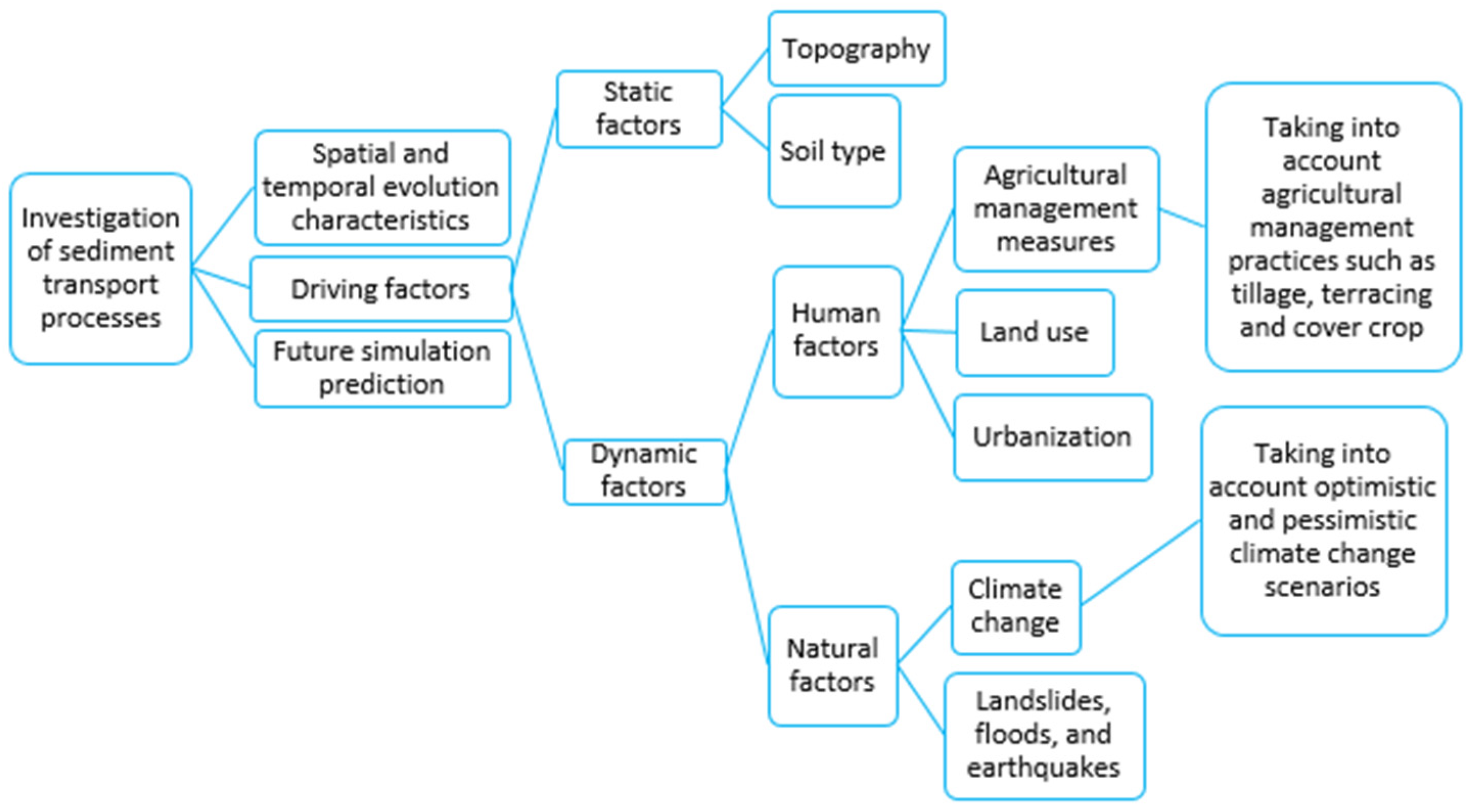
:1. Introduction
2. Materials and Methods
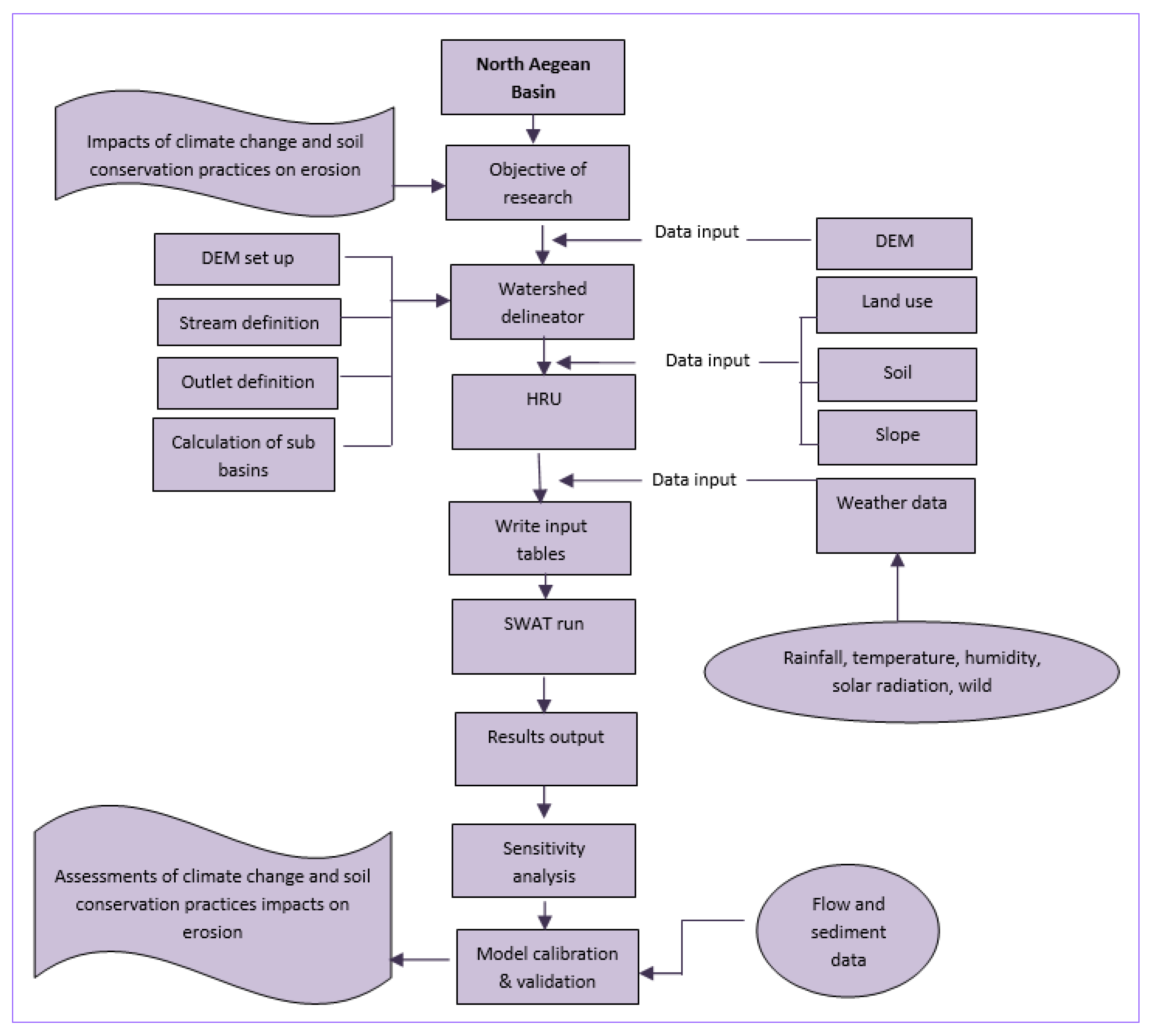
2.1. Methodology
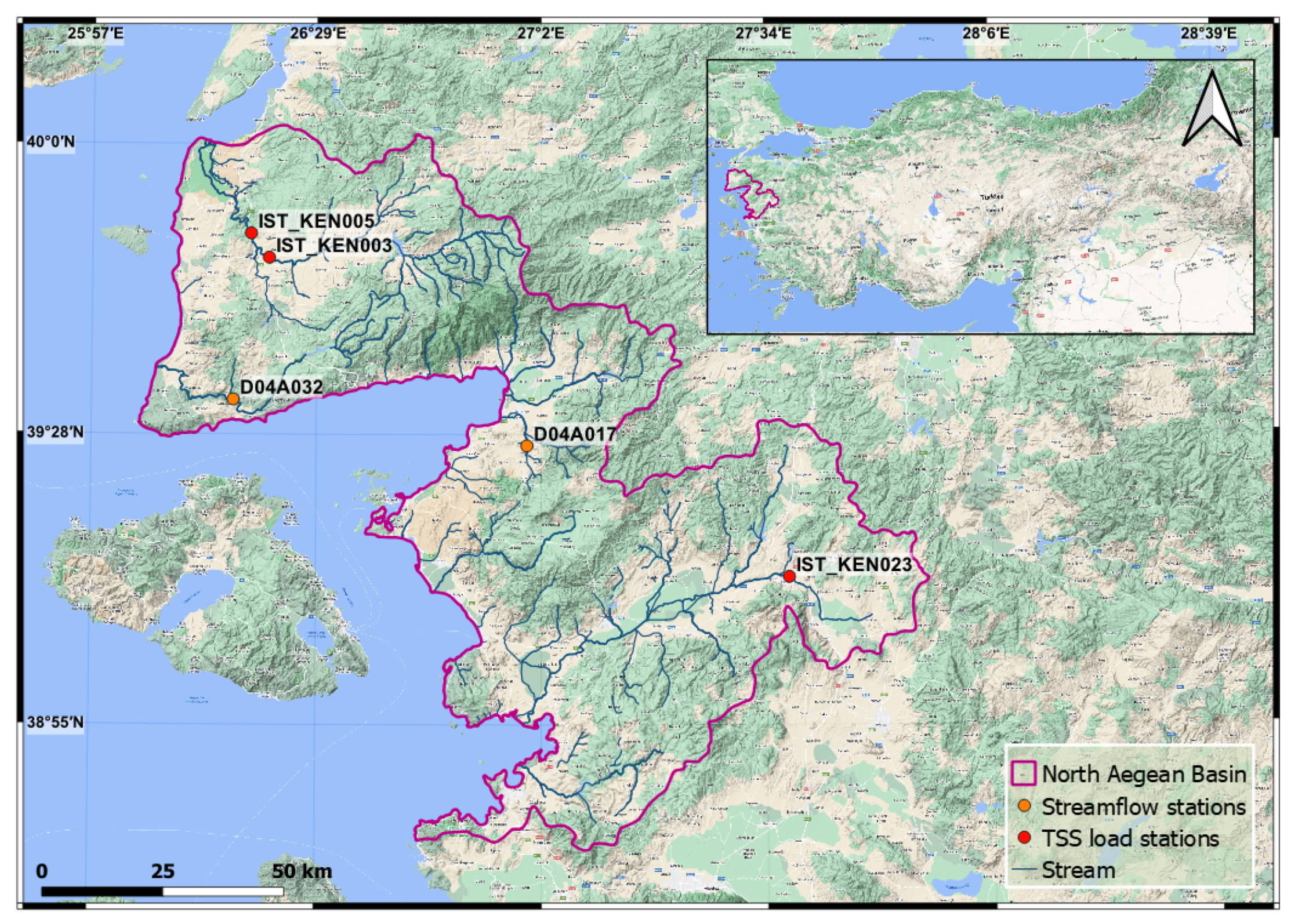
2.2. Study Area
2.3. Climate Change Projections
2.4. Application of Hydrological Model
2.5. Calibration and Validation
2.6. Agricultural BMPs
3. Results and Discussion
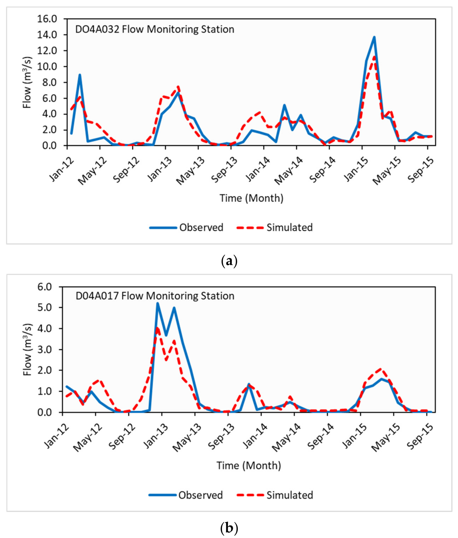
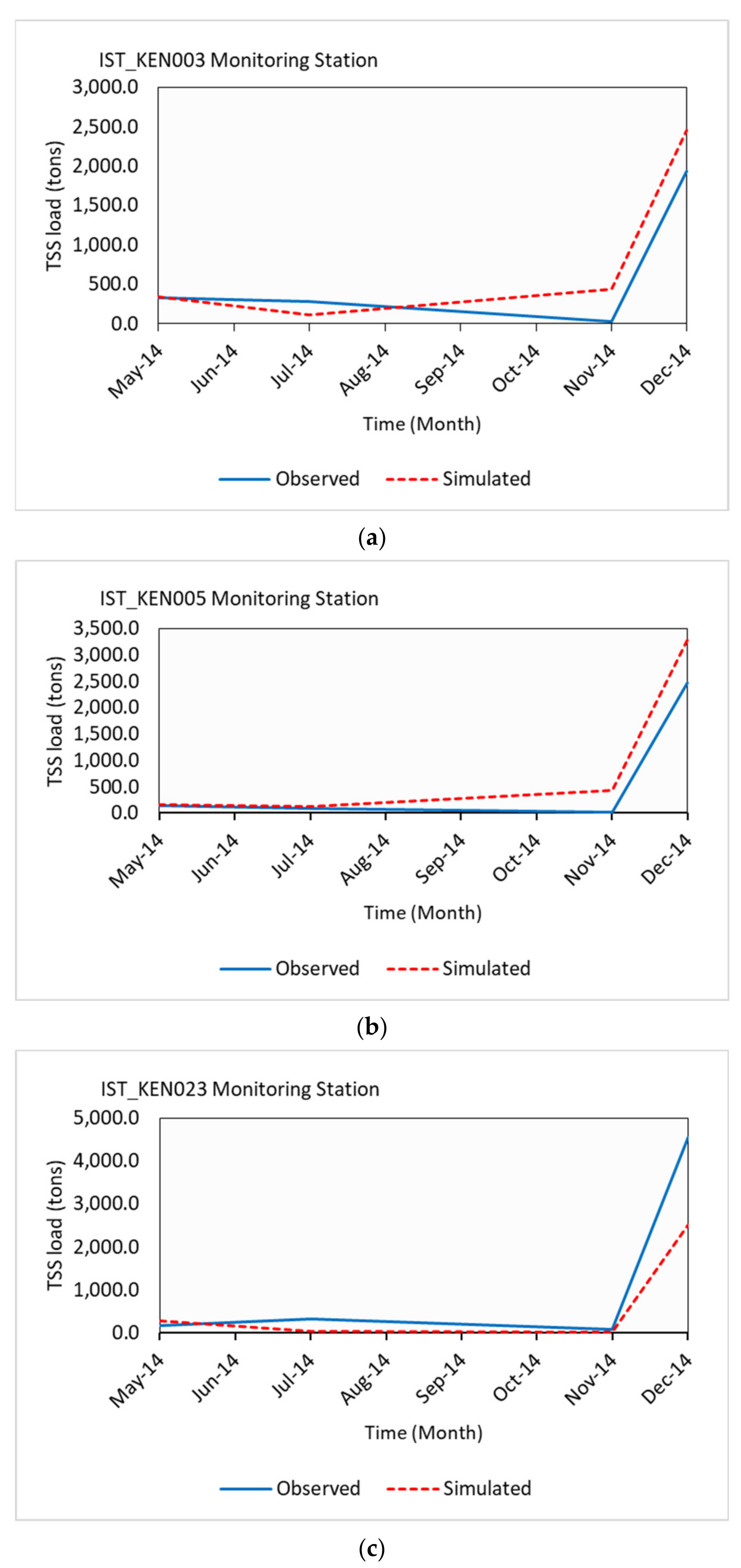
3.1. Model Performance Evaluation
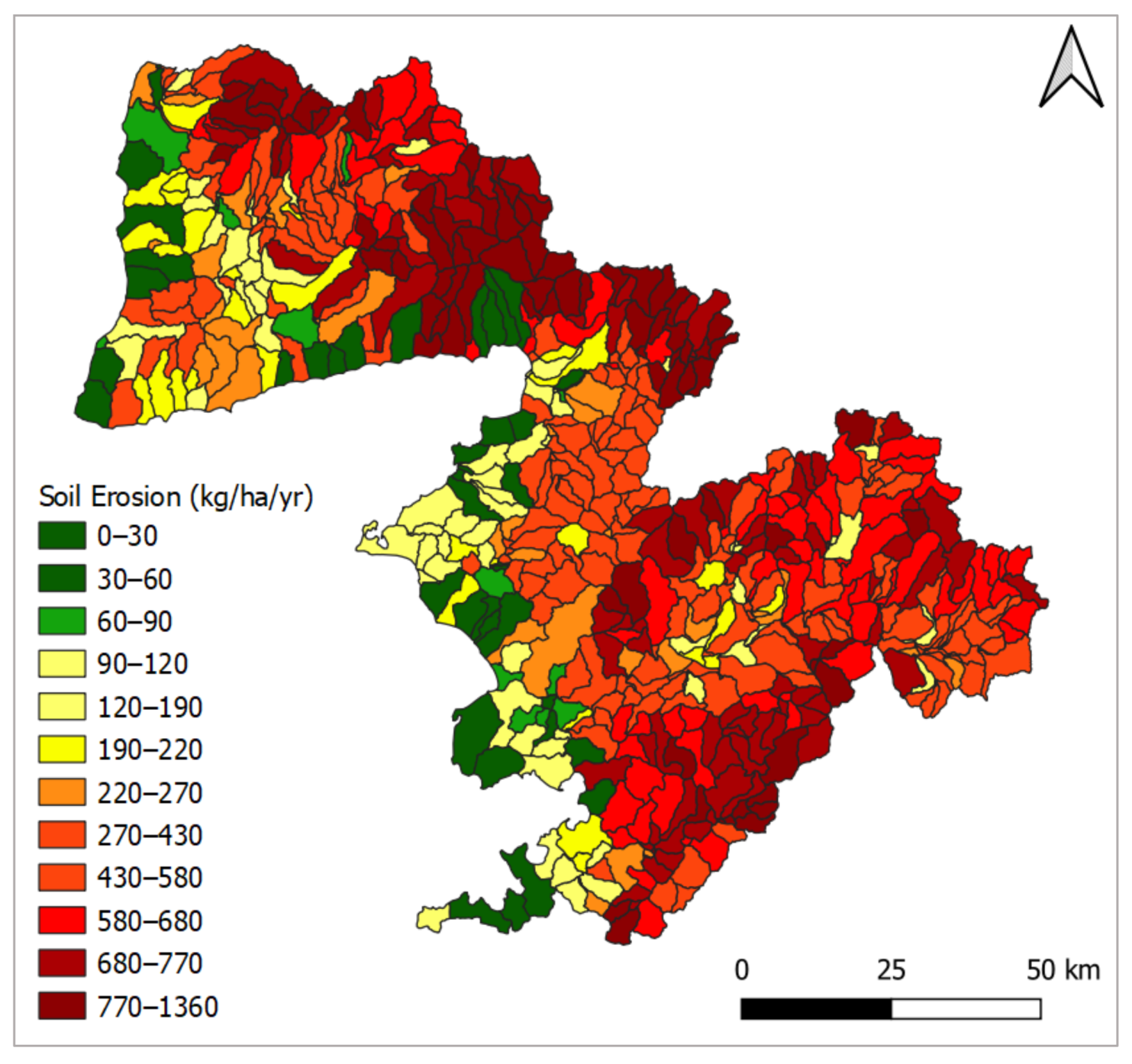
3.2. Basin Hydrology and Sediment Yield
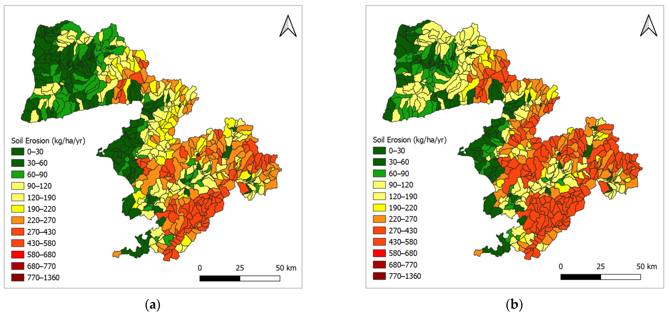
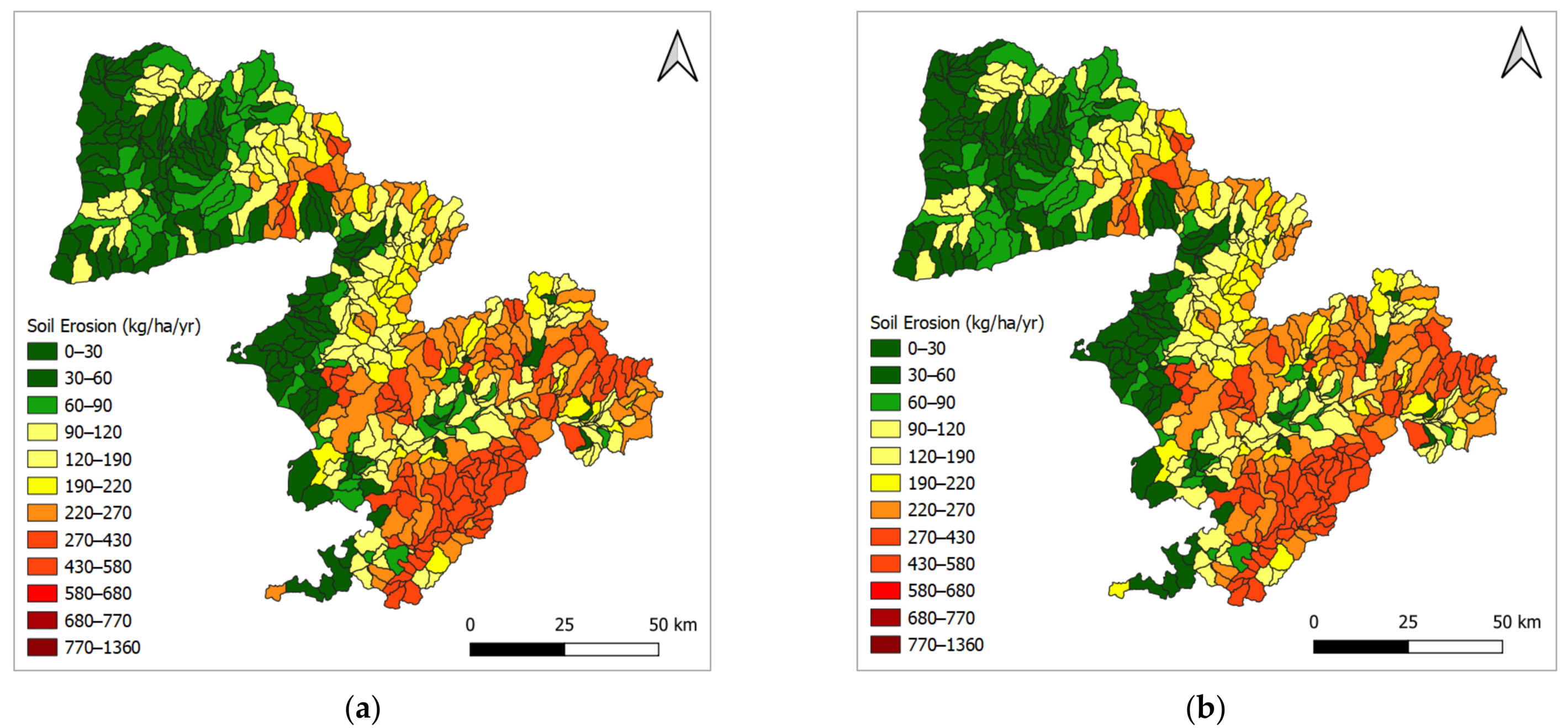
3.3. Impacts of Climate Scenarios on Basin Hydrology and Sediment Yield
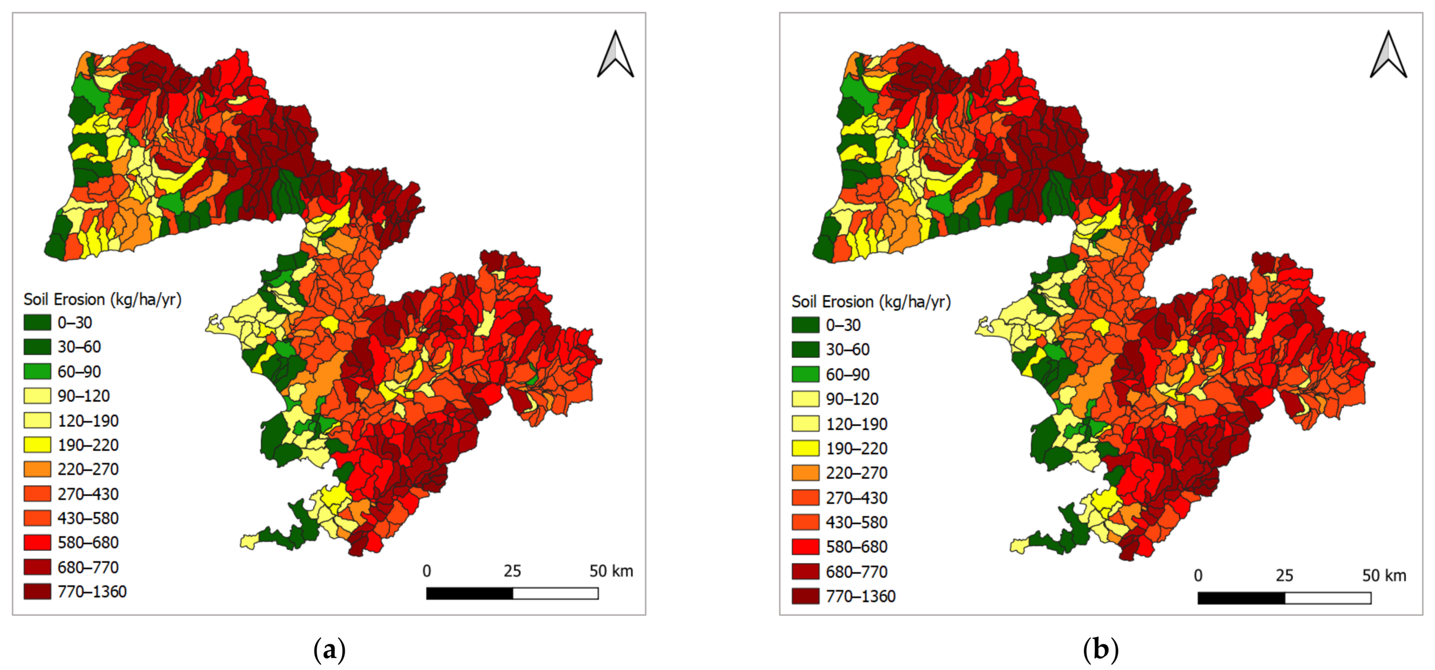
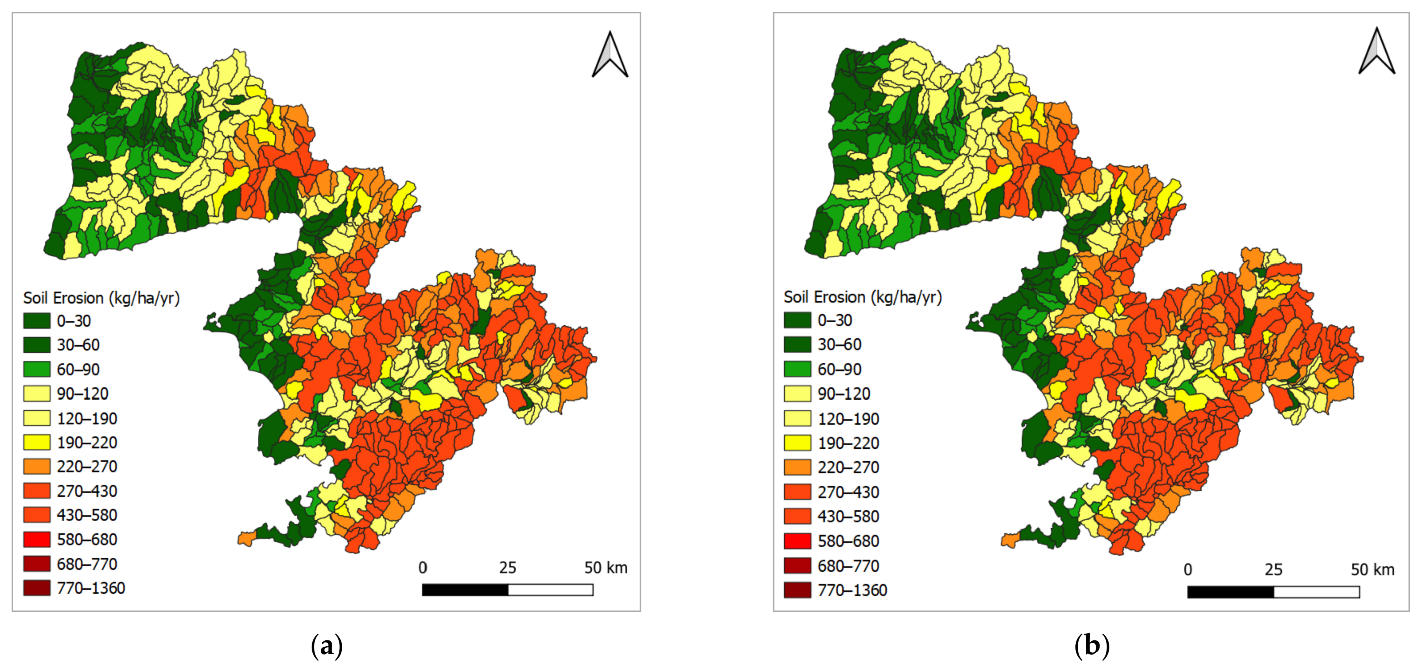
3.4. Evaluation of BMPs
4. Conclusions
Author Contributions
Funding
Data Availability Statement
Acknowledgments
Conflicts of Interest
References
- Zhang, X.; Wang, Z.; Reimus, P.; Ma, F.; Soltanian, M.R.; Xing, B.; Dai, Z. Plutonium reactive transport in fractured granite: Multi-species experiments and simulations. Water Res. 2022, 224, 119068. [Google Scholar] [CrossRef] [PubMed]
- Echogdali, F.Z.; Boutaleb, S.; Taia, S.; Ouchchen, M.; Id-Belqas, M.; Kpan, R.B.; Sajinkumar, K.S. Assessment of soil erosion risk in a semi-arid climate watershed using SWAT model: Case of Tata basin, South-East of Morocco. Appl. Water Sci. 2022, 12, 137. [Google Scholar] [CrossRef]
- Avci, B.C.; Kesgin, E.; Atam, M.; Tan, R.I. Modeling agricultural practice impacts on surface water quality: Case of Northern Aegean watershed, Turkey. Int. J. Environ. Sci. Technol. 2022, 20, 5265–5280. [Google Scholar] [CrossRef]
- Wang, Y.; Henning, S.; Poulain, L.; Lu, C.; Stratmann, F.; Wang, Y.; Wiedensohler, A. Aerosol activation characteristics and prediction at the central European ACTRIS research station of Melpitz, Germany. Atmos. Chem. Phys. 2022, 22, 15943–15962. [Google Scholar] [CrossRef]
- Hanief, A.; Laursen, A.E. SWAT modeling of hydrology, sediment and nutrients from the Grand River, Ontario. Water Qual. Res. J. 2017, 52, 243–257. [Google Scholar] [CrossRef]
- Sanlı, A.S.; Agaccioglu, H.; Sinan, I.; Kesgin, E.; Demir, I.; Tan, R.I. Statistical assessment of interbasin water transfer for karst areas (Turkey). Arab. J. Geosci. 2021, 14, 2342. [Google Scholar] [CrossRef]
- Şanlı, A.S.; Kesgin, E.; Tan, R.I.; Agaccioglu, H.; Demir, I.; Sinan, I. Effect of lake-water budget management preferences on optimum operating conditions and neighboring basins interacting: Case of Lake Beyşehir (Turkey). Sustain. Water Resour. Manag. 2022, 8, 12. [Google Scholar] [CrossRef]
- Gezici, K.; Kesgin, E.; Agaccioglu, H. Hydrological Assessment of Experimental Behaviors for Different Drainage Methods in Sports Fields. J. Irrig. Drain. Eng. 2021, 147, 04021034. [Google Scholar] [CrossRef]
- Liu, Z.; Xu, J.; Liu, M.; Yin, Z.; Liu, X.; Yin, L.; Zheng, W. Remote sensing and geostatistics in urban water-resource monitoring: A review. Mar. Freshw. Res. 2023, 74, 747–765. [Google Scholar] [CrossRef]
- Qin, Z.; Jin, J.; Liu, L.; Zhang, Y.; Du, Y.; Yang, Y.; Zuo, S. Reuse of soil-like material solidified by a biomass fly ash-based binder as engineering backfill material and its performance evaluation. J. Clean. Prod. 2023, 402, 136824. [Google Scholar] [CrossRef]
- Duru, U.; Arabi, M.; Wohl, E.E. Modeling stream flow and sediment yield using the SWAT model: A case study of Ankara River basin, Turkey. Phys. Geogr. 2018, 39, 264–289. [Google Scholar] [CrossRef]
- Xu, L.; Liu, X.; Tong, D.; Liu, Z.; Yin, L.; Zheng, W. Forecasting Urban Land Use Change Based on Cellular Automata and the PLUS Model. Land 2022, 11, 652. [Google Scholar] [CrossRef]
- Xu, Z.; Wang, Y.; Jiang, S.; Fang, C.; Liu, L.; Wu, K.; Chen, Y. Impact of input, preservation and dilution on organic matter enrichment in lacustrine rift basin: A case study of lacustrine shale in Dehui Depression of Songliao Basin, NE China. Mar. Pet. Geol. 2022, 135, 105386. [Google Scholar] [CrossRef]
- Nasirzadehdizaji, R.; Akyuz, D.E. Application of swat hydrological model to assess the impacts of land use change on sediment loads. Int. J. Agric. Environ. Food Sci. 2022, 6, 108–120. [Google Scholar] [CrossRef]
- Yang, Y.; Li, T.; Pokharel, P.; Liu, L.; Qiao, J.; Wang, Y.; Chang, S.X. Global effects on soil respiration and its temperature sensitivity depend on nitrogen addition rate. Soil Biol. Biochem. 2022, 174, 108814. [Google Scholar] [CrossRef]
- Yang, Y.; Dou, Y.; Wang, B.; Xue, Z.; Wang, Y.; An, S.; Chang, S.X. Deciphering factors driving soil microbial life-history strategies in restored grasslands. iMeta 2022, 2, e66. [Google Scholar] [CrossRef]
- Li, T.; Yu, X.; Li, M.; Rong, L.; Xiao, X.; Zou, X. Ecological insight into antibiotic resistome of ion-adsorption rare earth mining soils from south China by metagenomic analysis. Sci. Total Environ. 2023, 872, 162265. [Google Scholar] [CrossRef]
- Liu, Y.; Jiang, H. Sediment yield modeling using SWAT model: Case of Changjiang River Basin. In Proceedings of the 6th Annual 2018 International Conference on Geo-Spatial Knowledge and Intelligence, Wuhan, China, 14–16 December 2018; IOP Publishing: Bristol, UK, 2019; Volume 234, p. 012031. [Google Scholar]
- Almendinger, J.E.; Murphy, M.S.; Ulrich, J.S. Use of the Soil and Water Assessment Tool to scale sediment delivery from field to watershed in an agricultural landscape with topographic depressions. J. Environ. Qual. 2014, 43, 9–17. [Google Scholar] [CrossRef] [Green Version]
- Lin, X.; Lu, K.; Hardison, A.K.; Liu, Z.; Xu, X.; Gao, D.; Gardner, W.S. Membrane inlet mass spectrometry method (REOX/MIMS) to measure 15N-nitrate in isotope-enrichment experiments. Ecol. Indic. 2021, 126, 107639. [Google Scholar] [CrossRef]
- Yin, H.; Liu, Q.; Deng, X.; Liu, X.; Fang, S.; Xiong, Y.; Song, J. Organophosphate esters in water, suspended particulate matter (SPM) and sediments of the Minjiang River, China. Chin. Chem. Lett. 2021, 32, 2812–2818. [Google Scholar] [CrossRef]
- Xu, R.; Wang, Y.; Sun, Y.; Wang, H.; Gao, Y.; Li, S.; Gao, L. External sodium acetate improved Cr(VI) stabilization in a Cr-spiked soil during chemical-microbial reduction processes: Insights into Cr(VI) reduction performance, microbial community and metabolic functions. Ecotoxicol. Environ. Saf. 2023, 251, 114566. [Google Scholar] [CrossRef] [PubMed]
- He, M.; Dong, J.; Jin, Z.; Liu, C.; Xiao, J.; Zhang, F.; Deng, L. Pedogenic processes in loess-paleosol sediments: Clues from Li isotopes of leachate in Luochuan loess. Geochim. Cosmochim. Acta 2021, 299, 151–162. [Google Scholar] [CrossRef]
- Wang, X.; Wang, T.; Xu, J.; Shen, Z.; Yang, Y.; Chen, A.; Piao, S. Enhanced habitat loss of the Himalayan endemic flora driven by warming-forced upslope tree expansion. Nat. Ecol. Evol. 2022, 6, 890–899. [Google Scholar] [CrossRef] [PubMed]
- Alkattan MQ, M.; Khaleel MS, K. Estimate the Sediment Load Entering the Left Side of Mosul Dam Lake Using Four Methods. Int. J. Eng. Appl. Sci. 2017, 9, 60–74. [Google Scholar] [CrossRef]
- Yen, H.; Lu, S.; Feng, Q.; Wang, R.; Gao, J.; Brady, D.M.; Arnold, J.G. Assessment of optional sediment transport functions via the complex watershed simulation model SWAT. Water 2017, 9, 76. [Google Scholar] [CrossRef] [Green Version]
- Lu, C.M.; Chiang, L.C. Assessment of sediment transport functions with the modified SWAT-Twn model for a Taiwanese small mountainous watershed. Water 2019, 11, 1749. [Google Scholar] [CrossRef] [Green Version]
- Gull, S.; Ahangar, M.A.; Dar, A.M. Prediction of stream flow and sediment yield of Lolab watershed using SWAT model. Hydrol Curr. Res 2017, 8, 265. [Google Scholar] [CrossRef]
- Vigiak, O.; Malagó, A.; Bouraoui, F.; Vanmaercke, M.; Obreja, F.; Poesen, J.; Grošelj, S. Modelling sediment fluxes in the Danube River Basin with SWAT. Sci. Total Environ. 2017, 599, 992–1012. [Google Scholar] [CrossRef]
- Arnold, J.G.; Srinivasan, R.; Muttiah, R.S.; Williams, J. Large area hydrologic modeling and assessment part i: Model development. Jawra J. Am. Water Resour. Assoc. 1998, 34, 73–89. [Google Scholar] [CrossRef]
- Pandey, A.; Bishal, K.C.; Kalura, P.; Chowdary, V.M.; Jha, C.S.; Cerdà, A. Soil Water Assessment Tool (SWAT) Modeling Approach to Prioritize Soil Conservation Management in River Basin Critical Areas Coupled With Future Climate Scenario Analysis. Air Soil Water Res. 2021, 14, 11786221211021395a. [Google Scholar] [CrossRef]
- Ouyang, W.; Huang, H.; Hao, F.; Guo, B. Synergistic impacts of land-use change and soil property variation on non-point source nitrogen pollution in a freeze–thaw area. J. Hydrol. 2013, 495, 126–134. [Google Scholar] [CrossRef]
- Gurung, P.; Bharati, L.; Karki, S. Application of the SWAT model to assess climate change impacts on water balances and crop yields in the West Seti River Basin. In Proceedings of the 2013 International SWAT Conference, Toulouse, France, 15–19 July 2013. [Google Scholar]
- Yilmaz, M.T.; Bulut, B.; Afshar, M.; Yucel, I.; Aras, M.; Ozaltin, A.M.; Ozcam, B. Investigation of the Effects of Climate Change on Water Resources in Northern Aegean Basin. In Proceedings of the 10th National Hydrology Congress, Muğla, Turkey, 9–12 October 2019; pp. 351–363. [Google Scholar]
- Kale, S.; Ejder, T.; Hisar, O.; Mutlu, F. Effect of climate change on annual streamflow of Bakırçay River. Adıyaman Univ. J. Sci. 2016, 6, 156–176. [Google Scholar]
- Chiang, L.C.; Liao, C.J.; Lu, C.M.; Wang, Y.C. Applicability of modified SWAT model (SWAT-Twn) on simulation of watershed sediment yields under different land use/cover scenarios in Taiwan. Environ. Monit. Assess. 2021, 193, 520. [Google Scholar] [CrossRef] [PubMed]
- Xu, D.; Zhu, D.; Deng, Y.; Sun, Q.; Ma, J.; Liu, F. Evaluation and empirical study of Happy River on the basis of AHP: A case study of Shaoxing City (Zhejiang, China). Mar. Freshw. Res. 2023, 74, 838–850. [Google Scholar] [CrossRef]
- Arnold, J.G.; Moriasi, D.N.; Gassman, P.W.; Abbaspour, K.C.; White, M.J.; Srinivasan, R.; Santhi, C.; Harmel, R.D.; van Griensven, A.; Van Liew, M.W.; et al. SWAT: Model use, calibration, and validation. Trans. ASABE 2012, 55, 1491–1508. [Google Scholar] [CrossRef]
- Republic of Turkey, Ministry of Agriculture and Forestry. General Directorate of Water Management, 2020; North Aegean Basin Management Plan Preparation Project; Republic of Turkey, Ministry of Agriculture and Forestry: Ankara, Turkey, 2020.
- Tubitak Mam Environment Institute (EI). Preparation of Basin Protection Action Plans-North Aegean Basin (PBPAP); Tubitak Mam Environment Institute (EI): Gebze, Turkey, 2020.
- Republic of Turkey, Ministry of Environment. Urbanization and Climate Change Directorate General of Environmental Management, 2016; Pollution Prevention Action Plan for the North Aegean Basin; Republic of Turkey, Ministry of Environment: Ankara, Turkey, 2016.
- Republic of Turkey, Ministry of Environment. Urbanization and Climate Change Directorate General of Environmental Management, Department of Water and Soil Management, 2015; Pollution Prevention Action Plan for the North Aegean Basin; Republic of Turkey, Ministry of Environment: Ankara, Turkey, 2015.
- Zhang, S.; Bai, X.; Zhao, C.; Tan, Q.; Luo, G.; Wang, J.; Xi, H. Global CO2 Consumption by Silicate Rock Chemical Weathering: Its Past and Future. Earth’s Future 2021, 9, e1938E–e2020E. [Google Scholar] [CrossRef]
- IPCC, 2022: Climate Change 2022: Impacts, Adaptation and Vulnerability. Available online: https://report.ipcc.ch/ar6/wg2/IPCC_AR6_WGII_FullReport.pdf (accessed on 5 September 2022).
- Demircan, M.; Gurkan, H.; Eskioglu, O.; Arabaci, H.; Coskun, M. Climate Change Projections for Turkey: Three Models and Two Scenarios. Turk. J. Water Sci. Manag. 2017, 1, 22–43. [Google Scholar] [CrossRef]
- Neitsch, S.L.; Arnold, J.G.; Kiniry, J.R.; Williams, J.R. Soil and Water Assessment Tool Theoretical Documentation Version 2009; Technical Report No. 406; Texas Water Resources Institute: College Station, TX, USA, 2011.
- Neitsch, S.L.; Arnold, J.G.; Kiniry, J.R.; Williams, J.R.; King, K.W. Soil and Water Assessment Tool Theoretical Documentation Version 2005; US Department of Agriculture: Temple, TX, USA, 2005.
- Priestley CH, B.; Taylor, R.J. On the Assessment of Surface Heat Flux and Evaporation Using Large-Scale Parameters. Mon. Weather Rev. 1972, 100, 81–92. [Google Scholar] [CrossRef]
- Society, A.; Agricultural, O.F. Reference Crop Evapotranspiration from Temperature. Appl. Eng. Agric. 1985, 1, 96–99. [Google Scholar] [CrossRef]
- Monteith, J.L.; Moss, C.J. Climate and the Efficiency of Crop Production in Britain [and Discussion]. Philos. Trans. R. Soc. B Biol. Sci. 1977, 281, 277–294. [Google Scholar] [CrossRef]
- Soil Conservation Service Engineering Division (SCS). Section 4: Hydrology. In National Engineering Handbook; Department of Agriculture: Washington, DC, USA, 1972; pp. 10-1–10-22. [Google Scholar]
- Green, W.; Ampt, G. Studies on soil physics: 1. The flow of air and water through soils. J. Agric. Sci. 1911, 4, 11–24. [Google Scholar]
- Ayele, G.T.; Kuriqi, A.; Jemberrie, M.A.; Saia, S.M.; Seka, A.M.; Teshale, E.Z.; Melesse, A.M. Sediment yield and reservoir sedimentation in highly dynamic watersheds: The case of Koga Reservoir, Ethiopia. Water 2021, 13, 3374. [Google Scholar] [CrossRef]
- Williams, J.R. Sediment-yield prediction with universal equation using runoff energy factor. In Present and Prospective Technology for Predicting Sediment Yield and Sources: Proceedings of the Sediment-Yield Workshop, 28–30 November 1972; ARS-S-40; USDA Sedimentation Laboratory: Oxford, UK, 1975; pp. 244–252. [Google Scholar]
- Williams, J.R. The EPIC Model. Computer Models of Watershed Hydrology; Water Resources Publications: Highlands Ranch, CO, USA, 1995; pp. 909–1000. [Google Scholar]
- Wischmeier, W.H.; Smith, D.D. Predicting Rainfall Erosion Losses: A Guide to Conservation Planning; Department of Agriculture, Science and Education Administration: Seattle, WA, USA, 1978. [Google Scholar]
- Abbaspour, K.C.; Yang, J.; Maximov, I.; Siber, R.; Bogner, K.; Mieleitner, J.; Zobrist, J.; Srinivasan, R. Modeling of hydrology and water quality in the Pre-Alpine/Alpine Thur watershed using SWAT. J. Hydrol. 2007, 333, 413–430. [Google Scholar] [CrossRef]
- Mehan, S.; Neupane, R.P.; Kumar, S. Coupling of SUFI 2 and SWAT for Improving the Simulation of Streamflow in an Agricultural Watershed of South Dakota. Hydrol. Current Res. 2017, 8, 3. [Google Scholar] [CrossRef]
- Liu, Y.; Zhang, K.; Li, Z.; Liu, Z.; Wang, J.; Huang, P. A hybrid runoff generation modelling framework based on spatial combination of three runoff generation schemes for semi-humid and semi-arid watersheds. J. Hydrol. 2020, 590, 125440. [Google Scholar] [CrossRef]
- Sharpley, A.N.; Daniel, T.; Gibson, G.; Bundy, L.; Cabrera, M.; Sims, T.; Parry, R. Best Management Practices to Minimize Agricultural Phosphorus Impacts on Water Quality; ARS-163; USDA-ARS: Washington, DC, USA, 2006.
- Malik, M.A.; Dar, A.Q.; Jain, M.K. Modelling streamflow using the SWAT model and multisite calibration utilizing SUFI 2 of SWAT CUP model for high altitude catchments, NW Himalaya’s. Model. Earth Syst. Environ. 2021, 8, 1203–1213. [Google Scholar] [CrossRef]
- Sao, D.; Kato, T.; Tu, L.H.; Thouk, P.; Fitriyah, A.; Oeurng, C. Evaluation of different objective functions used in the sufi-2 calibration process of swat-cup on water balance analysis: A case study of the Pursat river basin, Cambodia. Water 2020, 12, 2901. [Google Scholar] [CrossRef]
- Hosseini, S.H.; Khaleghi, M.R. Application of SWAT model and SWAT CUP software in simulation and analysis of sediment uncertainty in arid and semi-arid watersheds (case study: The Zoshk–Abardeh watershed). Model. Earth Syst. Environ. 2020, 6, 2003–2013. [Google Scholar] [CrossRef]
- Khatun, S.; Sahana, M.; Jain, S.K.; Jain, N. Simulation of surface runoff using semi distributed hydrological model for a part of Satluj Basin: Parameterization and global sensitivity analysis using SWAT CUP. Model. Earth Syst. Environ. 2018, 4, 1111–1124. [Google Scholar] [CrossRef]
- Nepal, D.; Parajuli, P.B. Assessment of best management practices on hydrology and sediment yield at watershed scale in Mississippi using SWAT. Agriculture 2022, 12, 518. [Google Scholar] [CrossRef]
- Moriasi, D.N.; Arnold, J.G.; Van Liew, M.W.; Bingner, R.L.; Harmel, R.D.; Veith, T.L. Model evaluation guidelines for systematic quantification of accuracy in watershed simulations. Trans. ASABE 2007, 50, 885–900. [Google Scholar] [CrossRef]
- Setegn, S.G.; Srinivasan, R.; Assefa, B.D.; Melesse, M. Spatial delineation of soil erosion vulnerability in the Lake Tana Basin, Ethiopia. Hydrol. Process. 2009, 23, 3738–3750. [Google Scholar] [CrossRef]
- Tong, S.T.Y.; Liu, A.J.; Goodrich, J.A. Climate change impacts on nutrient and sediment loads in a midwestern agricultural watershed. J. Environ. Inform. 2007, 9, 18–28. [Google Scholar] [CrossRef]
- Bosch, N.S.; Evans, M.A.; Scavia, D.; Allan, J.D. Interacting effects of climate change and agricultural BMPs on nutrient runoff entering Lake Erie. J. Great Lakes Res. 2014, 40, 581–589. [Google Scholar] [CrossRef]
- Republic of Turkey, Ministry of Agriculture and Forestry. General Directorate of Water Management, 2019; North Aegean River Basin Management Plan Preparation Project, Coverage Report; Republic of Turkey, Ministry of Agriculture and Forestry: Ankara, Turkey, 2019.


| Data | Description | Period | Source |
|---|---|---|---|
| Digital Elevation Model (DEM) | Shuttle Radar Topography Mission (SRTM) Global: Raster resolution of 30 m | - | United States Geological Survey’s (USGS’s) Earth Explorer (https://earthexplorer.usgs.gov/ (accessed on 20 April 2021) |
| Land-use data | Raster resolution of 100 m | 2018 | CORINE Land Cover (https://land.copernicus.eu/pan-european/corine-land-cover (accessed on 4 May 2021)) |
| Soil data | Raster resolution of 100 m | - | FAO–UNESCO global soil map (https://www.fao.org/soils-portal/data-hub/soil-maps-and-databases/faounesco-soil-map-of-the-world/en/ (accessed on 27 May 2021)) |
| Meteorological data | Monthly meteorological data | 2010–2014 | Turkish State Meteorological Service (https://mgm.gov.tr/kurumsal/istasyonlarimiz.aspx (accessed on 5 April 2021)) |
| Climate change projection data | 2010–2030 | Bogazici University Center for Climate Change and Policy Studies (http://climatechange.boun.edu.tr/ (accessed on 5 October 2022 )) | |
| Hydrological data | Monthly discharge data of D04A017 and D04A032 stations | 2012–2015 | General Directorate of State Hydraulic Works (DSI) |
| Well data and the irrigated areas in the basin | - | T.R. Ministry of Agriculture and Forestry, General Directorate of Water Management [39] and TUBITAK MAM Environment Institute [40] | |
| Sediment data | Sediment data for IST_KEN003, IST_KEN005 and IST_KEN023 stations | 2014 | General Directorate of State Hydraulic Works (DSI) |
| Soil-Conservation Practices | Application Area (km2) | Application Area to Total Watershed Area (%) |
|---|---|---|
| Zero tillage | 2514.05 | 25.49 |
| Vertical tillage | 2595.08 | 26.32 |
| Cover crops | 2595.08 | 26.32 |
| Terracing | 2594.59 | 26.31 |
| Analysis | Station | R2 | NS | PBIAS |
|---|---|---|---|---|
| Streamflow calibration | D04A017 | 0.76 | 0.72 | 1.40 |
| D04A032 | 0.63 | 0.54 | −22.91 | |
| TSS load calibration | IST_KEN003 | 0.94 | 0.79 | −30.64 |
| IST_KEN005 | 0.96 | 0.80 | −46.96 | |
| IST_KEN023 | 0.90 | 0.70 | 44.89 | |
| Streamflow verification | D04A017 | 0.78 | 0.75 | 3.80 |
| D04A032 | 0.70 | 0.61 | −17.52 |
| Soil-Conservation Practices | Baseline Model (%) | RCP4.5 (%) | RCP8.5 (%) |
|---|---|---|---|
| Zero tillage | −0.71 | −1.16 | −1.12 |
| Vertical tillage | −0.32 | −0.43 | −0.40 |
| Cover crop | −0.78 | −2.18 | −2.15 |
| Terracing | −4.22 | −4.01 | −3.96 |
| Water Body | Subbasin No | Baseline Model Simulation with S3 | Baseline Model Simulation with S4 | RCP4.5 Simulation with S3 | RCP4.5 Simulation with S4 | RCP8.5 Simulation with S3 | RCP8.5 Simulation with S4 |
|---|---|---|---|---|---|---|---|
| Boz Lake | 92 | … | −0.158 | … | −0.126 | … | −0.065 |
| Yukarikiriklar Pond | 147 | −5.471 | −0.363 | −0.315 | −0.643 | −0.109 | −0.714 |
| Kemerdere Pond | 262 | … | −0.122 | … | −1.280 | … | −0.918 |
| Kestel Dam | 270 | … | −0.514 | … | −0.213 | … | … |
| Guzelhisar Dam | 367 | −1.540 | −0.406 | −0.845 | −0.703 | −0.060 | −0.321 |
| Bayramic Dam | 465 | … | −0.319 | … | −0.601 | … | −0.308 |
| Saribeyler Dam | 526 | … | −0.357 | … | −0.512 | … | −0.851 |
| Kul Dam | 546 | … | −0.541 | … | −0.461 | … | −0.732 |
| Havran Dam | 568 | … | −0.258 | … | −0.234 | … | −0.815 |
| Ayvacik Dam Lake | 617 | … | −0.339 | … | −1.023 | … | −0.864 |
| Yortanli Dam Lake | 634 | −0.758 | −0.158 | −0.296 | −0.321 | −0.837 | −0.845 |
| Madra Dam | 643 | −5.62 | −0.236 | −1.677 | −0.614 | −1.769 | −0.741 |
| Caltikoru Dam Lake | 649 | −3.51 | −0.472 | −2.619 | −0.788 | −3.057 | −0.715 |
| Sevisler Dam | 657 | −7.23 | −0.412 | −0.981 | −0.956 | −0.445 | −0.868 |
Disclaimer/Publisher’s Note: The statements, opinions and data contained in all publications are solely those of the individual author(s) and contributor(s) and not of MDPI and/or the editor(s). MDPI and/or the editor(s) disclaim responsibility for any injury to people or property resulting from any ideas, methods, instructions or products referred to in the content. |
© 2023 by the authors. Licensee MDPI, Basel, Switzerland. This article is an open access article distributed under the terms and conditions of the Creative Commons Attribution (CC BY) license (https://creativecommons.org/licenses/by/4.0/).
Share and Cite
Avcı, B.C.; Kesgin, E.; Atam, M.; Tan, R.I. Spatial-Temporal Response of Sediment Loads to Climate Change and Soil Conservation Practices in the Northern Aegean Watershed, Türkiye. Water 2023, 15, 2461. https://doi.org/10.3390/w15132461
Avcı BC, Kesgin E, Atam M, Tan RI. Spatial-Temporal Response of Sediment Loads to Climate Change and Soil Conservation Practices in the Northern Aegean Watershed, Türkiye. Water. 2023; 15(13):2461. https://doi.org/10.3390/w15132461
Chicago/Turabian StyleAvcı, Bekir Cem, Erdal Kesgin, Masume Atam, and Remziye Ilayda Tan. 2023. "Spatial-Temporal Response of Sediment Loads to Climate Change and Soil Conservation Practices in the Northern Aegean Watershed, Türkiye" Water 15, no. 13: 2461. https://doi.org/10.3390/w15132461