Article

Scaling Up Indigenous Rainwater Harvesting: A Preliminary Assessment in Rajasthan, India

1
Department of Water Resources Development and Management, Indian Institute of Technology Roorkee, Roorkee 247667, India
2
School of Water, Energy and Environment, Cranfield University, Bedford MK43 0AL, UK
*
Author to whom correspondence should be addressed.
Water 2023, 15(11), 2042; https://doi.org/10.3390/w15112042
Submission received: 21 April 2023 / Revised: 12 May 2023 / Accepted: 22 May 2023 / Published: 27 May 2023
(This article belongs to the Section Urban Water Management)

Abstract

:
Rainwater harvesting (RWH) has the potential to enhance the sustainability of ground and surface water to meet increasing water demands and constrained supplies, even under a changing climate. Since arid and semi-arid regions frequently experience highly variable spatiotemporal rainfall patterns, rural communities have developed indigenous RWH techniques to capture and store rainwater for multiple uses. However, selecting appropriate sites for RWH, especially across large regions, remains challenging since the data required to evaluate suitability using critical criteria are often lacking. This study aimed to identify the essential criteria and develop a methodology to select potential RWH sites in Rajasthan (India). We combined GIS modeling (multicriteria decision analysis) with applied remote sensing techniques as it has the potential to assess land suitability for RWH. As assessment criteria, spatial datasets relating to land use/cover, rainfall, slope, soil texture, NDVI, and drainage density were considered. Later, weights were assigned to each criterion based on their relative importance to the RWH system, evidence from published literature, local expert advice, and field visits. GIS analyses were used to create RWH suitability maps (high, moderate, and unsuited maps). The sensitivity analysis was also carried out for identified weights to check the inadequacy and inconsistency among preferences. It was estimated that 3.6%, 8.2%, and 27.3% of the study area were highly, moderately, and unsuitable, respectively, for Chauka implementation. Further, sensitivity analysis results show that LULC is highly sensitive and NDVI is the least sensitive parameter in the selected study region, which suggests that changing the weight of these parameters is more likely to decide the outcome. Overall, this study shows the applicability of the GIS-based MCDA approach for up-scaling the traditional RWH systems and its suitability in other regions with similar field conditions, where RWH offers the potential to increase water resource availability and reliability to support rural communities and livelihoods.

1. Introduction

Water is critical for maintaining environmental functions and as a natural resource for plant and animal survival [1,2]. With a changing climate, increasing seasonal variability in rainfall, steady declines in groundwater levels, and growing demands for water from different sectors, pressures on existing water resources are increasing. The United Nations World Water Development Report stated that nearly six billion people will live under conditions of limited water availability by 2050 [3], which would restrict development in many countries globally. Arid and semi-arid regions regularly face droughts, water shortages, and the availability of drinking water and water resources for agriculture. These regions represent about 50 million km2 [4], with groundwater (GW) often being the primary source for meeting domestic, agricultural, and industrial water demands. To increase water availability for crop and livestock production, local communities have developed indigenous techniques to harvest rainwater to replenish GW and provide additional water supplies that last through the subsequent dry season [5]. Techniques include using rainwater harvesting (RWH) structures that capture runoff, allowing it to infiltrate the subsurface. The primary role of RWH techniques is to increase the amount of available water by capturing excess rainwater in one area for local use or transfer to another location [6]. Such harvested excess rainwater is relatively clean, and the quality is usually acceptable for many purposes, often requiring little treatment [7,8].
Indigenous RWH techniques have been developed to cope with different challenges of water shortages, for example, in Jordan, Palestine, Syria, Saudi Arabia, Tunisia, and Iraq [9,10,11]. Rajasthan in India also has many local RWH practices suitable for dry to arid climatic regions. The most common RWH structures in Rajasthan include the Talab (otherwise known as lakes or large reservoirs constructed in natural depressions or valleys), Johad (small earthen check dams that capture and conserve rainwater), Bandha (a stone check dam built across a stream or gully, to capture monsoon runoff), Sagar (large lakes), Nala bunds (embankments constructed across gullies for checking velocity of runoff, increasing water percolation) and Baoli (step wells) [12]. Another traditional RWH technique, known locally as Chauka, is an infiltration pond developed to support pastoral lands in the early dry season in Rajasthan. The Chauka system consists of bunds to trap rainfall runoff and cause it to infiltrate the soil instead of running off into the river [13]. Recently this technique has been evaluated through field studies, which revealed that the Chaukas allow approximately 5% additional rainfall to be available as recharge [14]. A recent study [15] linked Chaukas to nature-based solutions (NBS) and reported numerous benefits, such as recharging GW, avoiding GW contamination, irrigating downstream areas, for spiritual purposes and for nature. However, Chaukas are currently only implemented in four different villages of Rajasthan: Lapodiya, Antoli, Dethani, and Balapura, to improve the pastureland for rural communities. Considering the impacts of climate change on water resources, there is significant scope for Chaukas to be scaled up and implemented in other arid and semi-arid regions in Rajasthan and elsewhere globally. Further, upscaling potential RWH sites, especially across large regions, remains challenging since the data required to evaluate suitability using key criteria are often lacking.
Scaling up indigenous RWH techniques depends on the identification of suitable sites [6]. Various methodologies have been developed for selecting potential RWH sites, which include remote sensing (RS) and geographical information systems (GIS) in combination with various multicriteria decision analysis and hydrological modeling approaches [9,16,17]. However, the application of RS and GIS along with multicriteria decision analysis (MCDA) has gained importance as it provides a systematic methodology for the complex problems to locate potential regions for soil and water conservation structures and artificial/traditional GW recharge techniques [18,19,20,21,22]. Further, reviewers have identified various types of discrete MCDA techniques, such as multi-attribute utility theory (MAUT), simple additive weighting (SAW), analytic network process (ANP), technique for order of preference by similarity to ideal solution (TOPIIS), preference ranking organization method for enrichment of evaluations (PROMETHEE) and Analytical Hierarchy Process (AHP). Recently, the AHP technique gained huge importance and included various site suitability analyses such as groundwater potential zone, managed aquifer recharge sites, flood zone suitability maps, and potential RWH systems [23,24,25,26,27]. Further, it solves complex problems by incorporating subjective opinions from experts and provides a reproducible and transparent methodology [24]. For further information on AHP, the readers may refer to studies such as [28,29,30].
Considering the problem definition and data availability, researchers have used surface spatial and meteorological parameters such as slope, land use land cover (LULC), geomorphology, soil, drainage density, proximity to water bodies, rainfall, and subsurface hydrological parameters including aquifer thickness, GW level, and other aquifer parameters to identify potential RWH regions [18,31,32]. In this context, all hydrogeological and meteorological factors were carefully examined based on available information on Chaukas to ensure their successful implementation using a GIS-based MCDA approach. The suitable sites, identified by scientific data and local knowledge, will help improve planning of rainwater harvesting using an indigenous technique such as the Chauka system in other similar hydroclimatic conditions, which will in turn provide more extensive benefits for the community living in these regions. Further, integrating hydrometeorological data with local knowledge about the Chauka system on a large scale can upscale the locally adopted Chauka system in other similar hydroclimatic conditions. This study aimed to define site selection criteria and assess Chaukas as an RWH technique that could be scaled up and applied widely to other arid and semi-arid regions across Rajasthan and, more broadly, across India. A sensitivity analysis was performed to determine the efficacy of each parameter and the robustness of the Chauka construction suitability model.

2. Materials and Methods

A methodology was developed involving evidence synthesis to support the development of a conceptual framework which would assess Chaukas’ suitability, together with field visits to collect locally relevant data and GIS spatial analyses to model and map land suitability. Local practitioners provided information on Chaukas’ construction. A brief description of the study area, conceptual framework development, data collection, and GIS modeling approaches are outlined below.

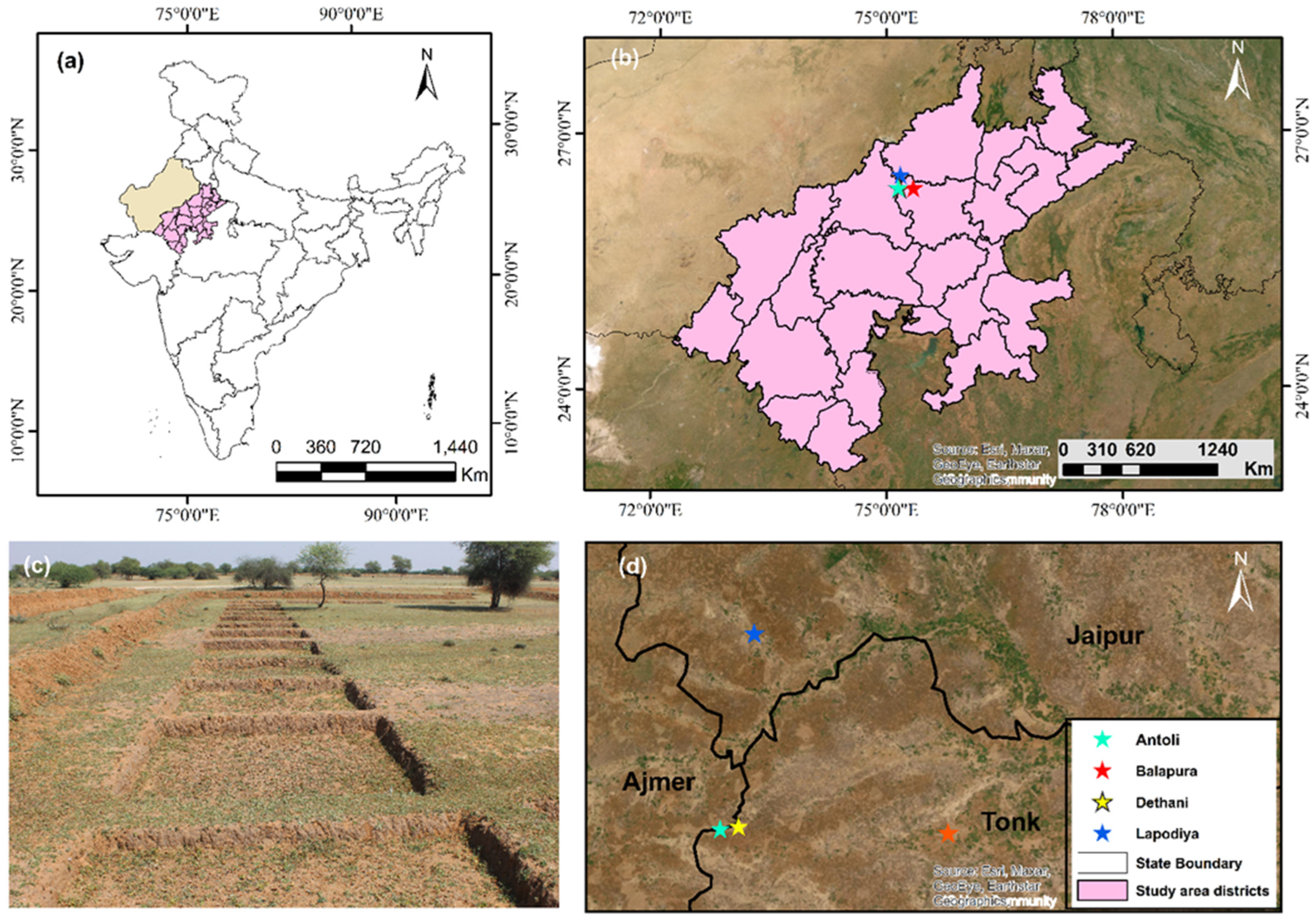
2.1. Description of the Study Area

Rajasthan is located in the northwestern part of India. It is popularly known as the desert state of India, where 90% of rural and 50% of urban water supply is met by groundwater [33]. This region experiences an arid/semi-arid climate with an annual average rainfall of 574 mm [34,35]. Approximately 90% of rain is concentrated during the monsoon season between June and September [15]. Most rainfall occurs at the beginning of the rainy season, which is mainly used for replenishing soil moisture, but some are also lost to evaporation due to arid conditions. The amount contributing to groundwater storage is 5% to 7% in areas underlain by hard rocks and 10% to 15% in alluvial regions [33]. High temperatures and low precipitation occur in the summer (February– June), with cold-dry weather in winter (November–January).
Rajasthan has a reasonably mature topography developed during a long period of denudation and erosion. Physiographically, the state can be divided into four units: Aravalli hill ranges, Eastern plains, Western Sandy Plain and Sand Dunes, and Vindhyan Scarpland and Deccan Lava Plateau. The sandy plains in western Rajasthan, forming a part of the Thar Desert, are mainly occupied by alluvium and blown sands [33]. Our study (Figure 1) did not include the western half of Rajasthan as it was known to be unsuited for Chauka construction due to its prevalence of desert cover (loose sand/sand dunes).
The principal source of recharge to groundwater in Rajasthan is rainfall. Due to the scarcity of surface water resources, smallholder agriculture depends mainly on the monsoon season and GW during the dry season. In the study area, RWH is practiced, and many water conservation measures (e.g., farm ponds, percolation ponds, check dams, and shallow infiltration ponds) have been constructed by the local non-government organization (GVNML) and government organizations. Without adequate surface and groundwater resources, rainwater plays a vital role in supporting livelihoods in arid and semi-arid regions. If rainwater can be harvested on a large scale, it could be a reliable source of potable water for domestic purposes.

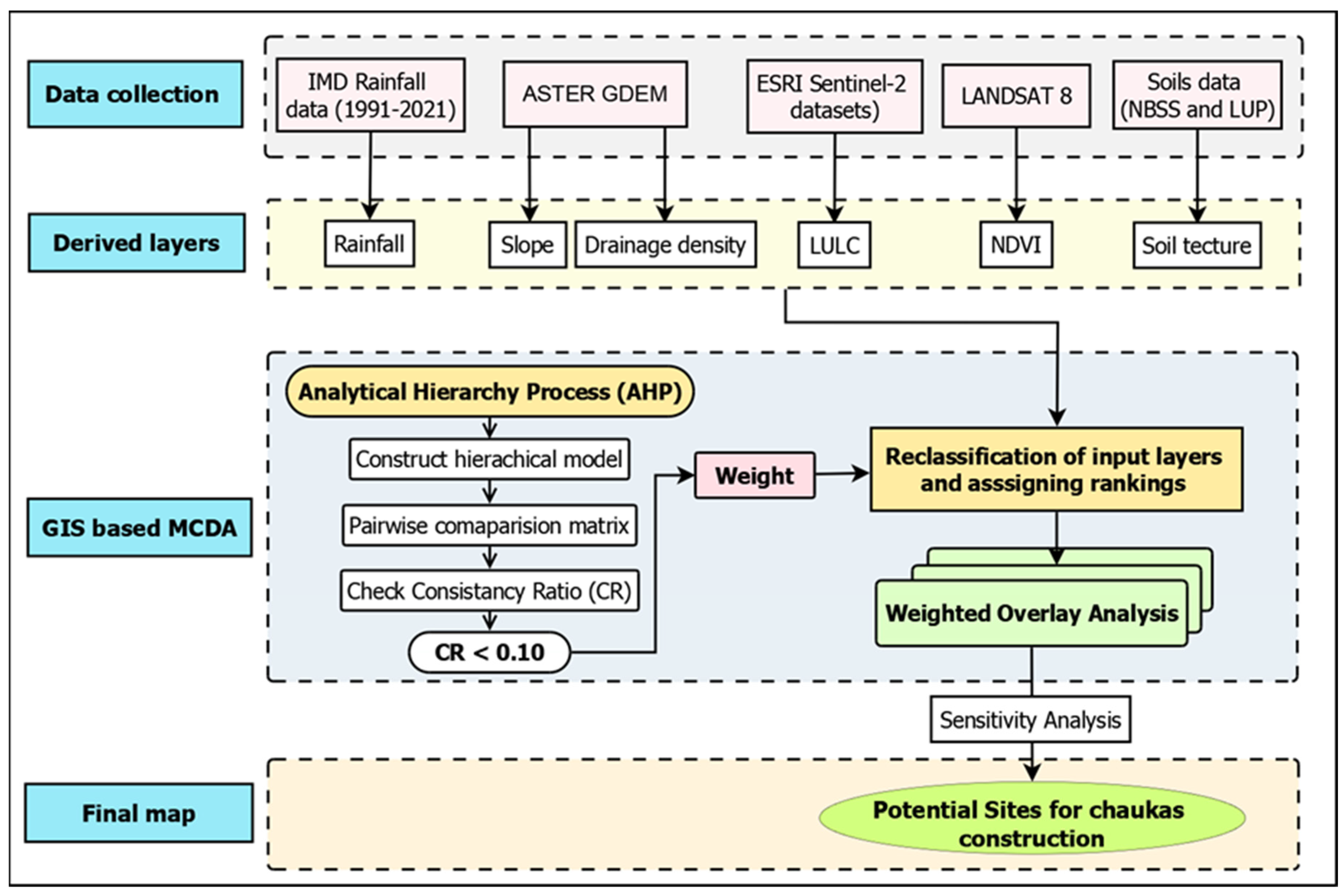
2.2. Conceptual Workflow

A conceptual workflow was developed to define the essential criteria, attributes of relevance, and thematic layers, including the processes of reclassification (ranking) and weighting using GIS and analytical hierarchy processes (AHP) (Figure 2). The workflow was categorized into five phases: (i) selection of appropriate criteria to identify potential sites and their reclassification, (ii) assigning weights to the criteria and their normalization, (iii) ranking (reclassifications of) the sub-criteria, (iv) using GIS analyses to combine spatial data and generate Chauka suitability maps, and (v) evaluation and validation of potential Chauka sites. The details of these phases are discussed in Section 2.3, Section 2.4 and Section 2.5.

2.3. Defining Assessment Criteria

In [36], the author identified six critical relevant criteria for RWH implementation, including local climate, hydrology, topography, agronomy, soil, and socioeconomics [37]. However, in this study, only five of those criteria relating to climate (average annual rainfall), hydrology (drainage density), topography (slope), agronomy (normalized vegetation index (NDVI), land use/cover, and soil texture were considered. Spatial datasets for each criterion were retrieved from institutional websites and data sources (Table 1). According to the variability in LULC, soil texture, and rainfall classes (which defined the Chauka’s suitability), each criterion was then sub-divided into three categories based on the existing class of each thematic layer and their suitability to Chaukas with the most suitable ranked “3”, moderately suitable ranked “2” and unsuitable ranked “1”.

2.3.1. Soil Texture

Soil texture determines the amount of water that can be stored within an RWH structure as it affects the surface runoff and rate of infiltration in the soil profile [38]. Soil information for the Rajasthan state was obtained from the National Bureau of Soil Survey and Land Use Planning [39]. The ideal soil for constructing Chaukas is fine and medium-textured soils because of their high unsaturated water holding capacity [40]. The soils with high clay content lead to increased runoff and decreased infiltration, while sandy soils exhibit the opposite effect [41]. Loam, sand, loamy sand, and sandy loam are considered the most suitable soils for infiltration systems [42]. All others are deemed impermeable and were excluded from our analysis. Therefore, loamy soil was ranked highest (3) for soil texture. Sandy soil, which has a high infiltration rate, was ranked ‘2’, and rocky outcrops, clayey, clay skeletal, loamy skeletal, and other subclasses were ranked ‘1’.

2.3.2. Slope

Slope plays a key role in GW occurrence as infiltration is inversely proportional to the slope [43]. The slope characteristics for the study site were generated from the Advanced Spaceborne Thermal Emission and Reflection Radiometer (ASTER) DEM with a 30 m resolution. The data was processed in ArcGIS v10.4 spatial analyst environment to derive the slope layer. The construction of Chaukas is generally preferred on low gradient slopes with a range of ≤0.5–2.0% [40]. The local Chauka expert suggested that a maximum slope of up to 7% in areas meeting other criteria is acceptable. Any slope outside the standard slope range was considered unsuitable. The slope was categorized into three classes: rank ‘3’ for slopes ranging between 0–3%, ‘2’ for slopes ranging between 3 and 7%, and ‘1’ for slopes > 7%.

2.3.3. Land Use Land Cover (LULC)

Land use plays a crucial role in the hydrological changes in the water cycle as it affects various processes such as overland flow, evapotranspiration, infiltration, and aquifer recharge [44]. LULC for 2020 derived from Esri Landscape was used for better accuracy, based on ESA Sentinel-2 imagery with a 10 m resolution. The LULC classification by Esri Landscape includes cropland, bare land, scrubland, forest, flooded vegetation, built-up areas, and water bodies. Chaukas are usually constructed in barren land that is not used for agriculture [15] and were considered ‘best’ for potential rainwater harvesting sites and ranked ‘3’. Forests have low overland flow conditions [45] and can be designated for RWH if needed and were therefore considered ‘good’ for potential rainwater harvesting site and ranked ‘2’. Urban areas have limited percolation, hence were deemed poor for recharge potential sites along with the agricultural lands, which are not considered for Chauka construction as they are needed for food crops. Accordingly, both were ranked ‘1’ including ‘other’ sub-classes such as built-up areas, water bodies, and flooded vegetation.

2.3.4. Rainfall

Groundwater recharge potential is closely linked to rainfall and directly impacts water percolation into the subsurface. The historical 30-year (1991–2020) gridded annual rainfall data for the study area were obtained from the Indian Meteorological Department (IMD). ArcGIS v10.4 was used to process the data and derive average annual rainfall values for the state. The Inverse Distance Weight (IDW) interpolation technique was employed to estimate rainfall in areas without direct measurements. Researchers [46] reported that a mean annual rainfall of 150–750 mm/year was suitable for most RWH techniques to be effective, and [47] reported that a cumulative annual rainfall of 200–300 mm in the Indian semi-arid tropics was necessary to initiate surface runoff for rainwater storage. Based on these findings, annual rainfall in the study area was classified into three categories, including a low range with minimum significance for RWH structures < 400 mm ranked ‘1’, medium annual rainfall range 400–700 mm assigned ‘2’, and rainfall > 700 mm ranked ‘3’.

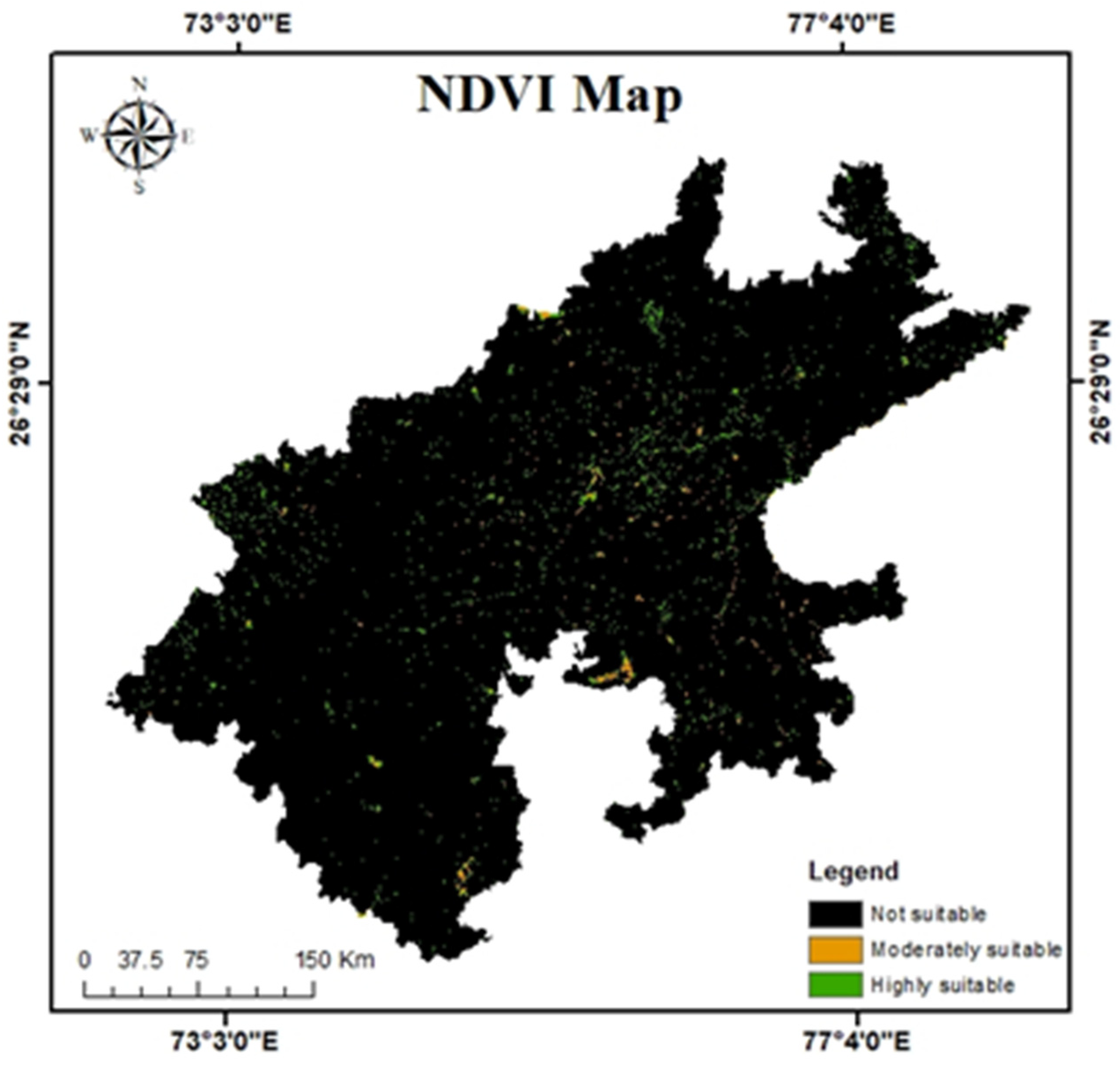
2.3.5. Normalized Difference Vegetation Index (NDVI)

Vegetation significantly impacts soil infiltration, as the vegetation cover can directly influence the amount of runoff. NDVI data were obtained for eight years (2013–2020) using Landsat 8 imagery processed through Google Earth Engine to evaluate the vegetation cover in the study area. The NDVI data provides valuable information on the ability of the land to support RWH by quantifying the vegetation cover. NDVI ranges between −1 and +1, where positive values indicate the presence of vegetation, while negative or near-zero values indicate non-vegetated regions, such as rock, soil, or water surfaces [38]. NDVI values were classified into three classes; values ranging from 0.1–0.2 were given rank ‘3’ as the range represents barren land and values, ranges from 0–0.1 were ranked ‘2’, and any values >0.2 and <0 were ranked ‘1’.

2.3.6. Drainage Density

Drainage density relates to the drainage efficiency of a catchment and is the total stream length of a given basin divided by the basin area. It is a morphometric parameter and determines infiltration characteristics and surface runoff process. It reflects the subsurface hydrological formation and surface features. It shows the surface material’s nature and channel spacing closeness [38]. ArcGIS 10.4 was used to derive the drainage density layer using the ASTER DEM data layer. Drainage density and permeability have an inverse relationship; for example, low permeability strata allow low rainfall infiltration, which increases surface runoff and leads to a well-developed drainage system and high drainage density. The higher the drainage density, the higher the potential for RWH [28]. The class ranging from 0.31–0.65 was assigned rank ‘3’, while 0.17 to 0.31 was ranked ‘2’, and the class ranging from 0–0.17 was ranked ‘1’.

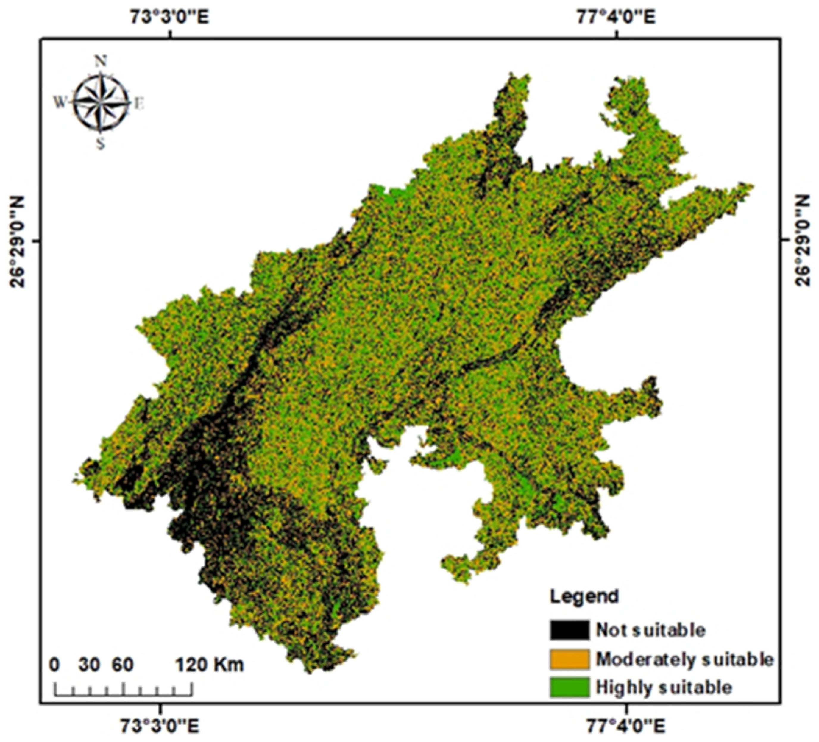
2.4. GIS Analysis and Production of Suitability Maps

Thematic layers required for identifying potential sites for Chaukas were developed using a GIS with raster and vector databases. The Analytical Hierarchy Process (AHP) was used to assign weights to individual criteria and to model the complex problem within a hierarchical structure. The AHP method [48] includes hierarchical structuring, pairwise comparisons, judgments, an eigenvector method for deriving weights, and consistency considerations [49]. In this study, AHP was applied within the GIS in two steps. First, the criteria maps were analyzed to determine the weights associated with each criterion using a preference matrix created through pairwise comparison of the relevant criteria using Saaty’s pairwise comparison scale (Table 2). Secondly, the AHP method was used to aggregate the priority for all levels in the hierarchy, including the level of the alternative. AHP allowed us to prioritize the various factors and make informed decisions on selecting suitable Chauka sites.
The final pairwise comparison matrix for all criteria is provided in Table 3. For example, the first row has a LULC value equal to LULC; thus, it was marked as ‘1’; and then LULC compared to soil texture, rainfall, drainage density, slope, and NDVI was scored on a scale from 2 to 9. After assigning the values in the matrix, weights were derived by taking the average values in each row to obtain a corresponding weighting. Since Chaukas are usually constructed in barren land that is not used for agriculture or other activities, LULC was given a higher weighting than other criteria. Soil texture was given the second highest weighting since soil permeability is a critical component that affects how much water is infiltrated into the soil. The third highest weighting was given to drainage density. Rainfall was given the next weighting because there were few differences in rainfall patterns across the study area. Slope and NDVI were given nearly equal weightings.
After the weighting was produced for all criteria, the consistency ratio (CR) was then used to verify the degree of consistency in developing the ratings.
CR = λ m a x n n 1 ( R I )
where λmax is the largest or principal eigenvalue of matrix A, n is the order of the matrix, and RI corresponds to the average of the resulting consistency index depending on the order n . The consistency ratio indicates the probability that the matrix ratings were randomly generated. A standard CR threshold value of 0.1 was adopted in literature as a measure of the judgments’ consistency in AHP applications [50]. If the CR < 0.1, it implies the pairwise comparison matrix has acceptable consistency, and the weighted values can be utilized. If the CR ≥ 0.1, then the matrix lacks consistency, and the element values need to be modified.

2.5. Criteria Classification

After producing thematic maps for each layer, an MCDA was applied within a GIS environment using the weighted overlay process. GIS-MCDA combines data from several themes by converting cell values to a standard scale (classes), assigning weights, and aggregating the weighted cell values. Scaled maps for each thematic layer were produced (Appendix A). Table 4 presents the rating and weights assigned for individual criteria and sub-criteria.

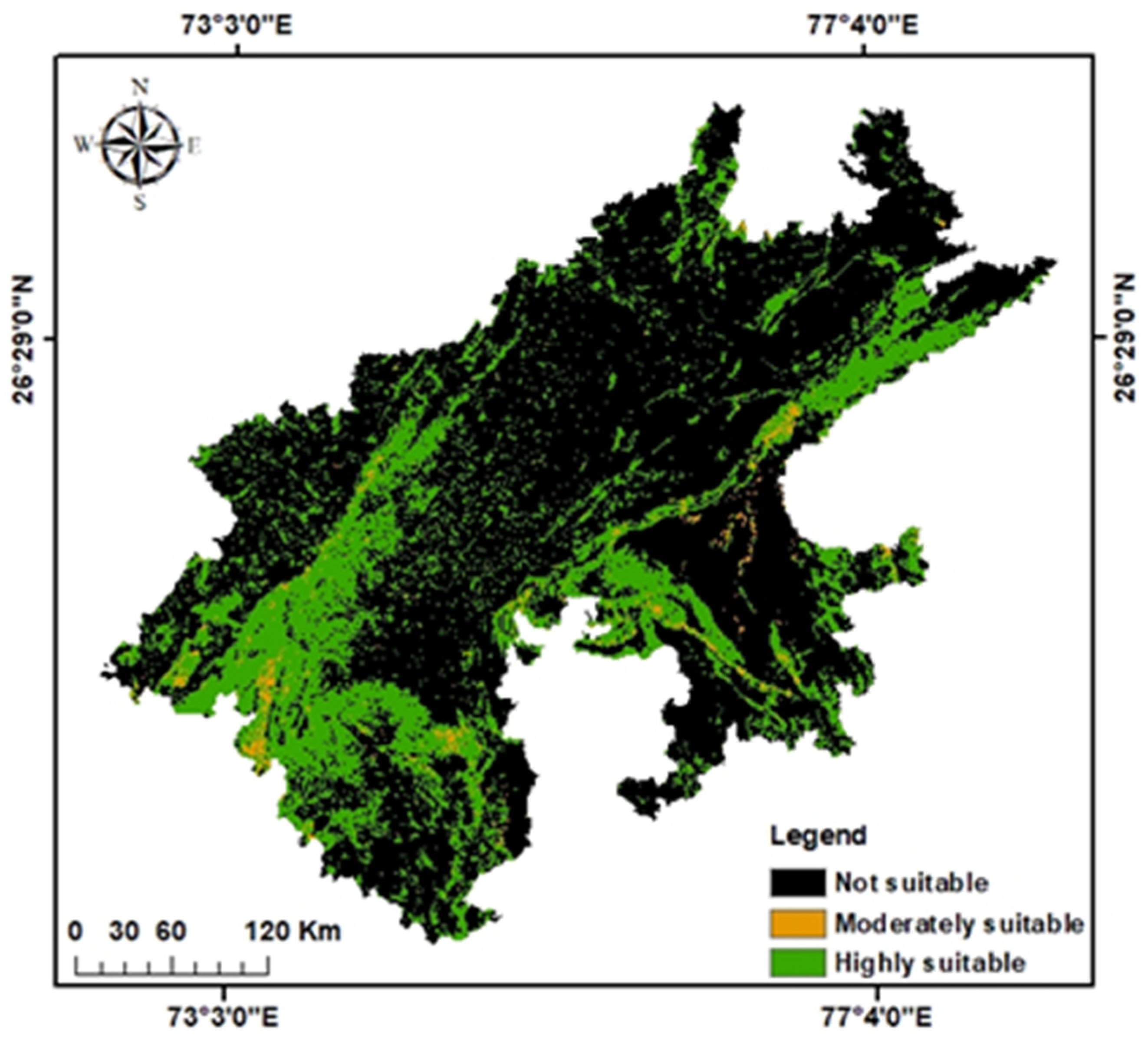
2.6. Evaluation and Validation of the Suitable Potential RWH Sites

Two approaches were used to evaluate and validate the potential RWH sites and their associated criteria. First, eight locations were identified; four sites were randomly selected from suitable, moderately suitable, and unsuitable areas, and four existing Chauka sites at Antoli, Balapura, Dethani, and Lapodiya. The existing Chauka sites were evaluated to ensure that their characteristics were consistent with the RWH suitability criteria. Secondly, the land suitability mapping was enhanced by incorporating data on water quality, specifically groundwater electrical conductivity and fluoride concentration, and overlaying the road network layer. This information was used to assess the environmental impacts of Chaukas and to ensure the availability of appropriate infrastructure for the operation and maintenance of the Chaukas. GW quality data were collected from the Ground Water Authority of India. The data were interpolated spatially using the inverse distance weighted (IDW) technique within the GIS, which establishes the value for each grid node by considering neighboring data points within a specified radius.

2.7. An OAT-Based Sensitivity Analysis

Decision making often involves uncertainty due to inadequate or imprecise information and inconsistency among preferences. In sensitivity analysis, the criteria weight is a more common approach than changing criteria values because weights include a subjective number with which decision makers may disagree [51]. This study used a time (OAT) method to observe how the output changes in response to changes in the weighting of different input parameters, to assess how the RWH model behaved [52]. Therefore, we considered the weights of each input parameter (Wi) 10%, 20%, 30%, 40%, 50%, and 60% while keeping other input parameters equally distributed (W2 = W3 = W4 = W5 = (100 − W1)/4) and where ∑(Wi = 1). Each weighting scheme was examined to determine how the percentage areas under moderately and highly suitable categories changed.

3. Results

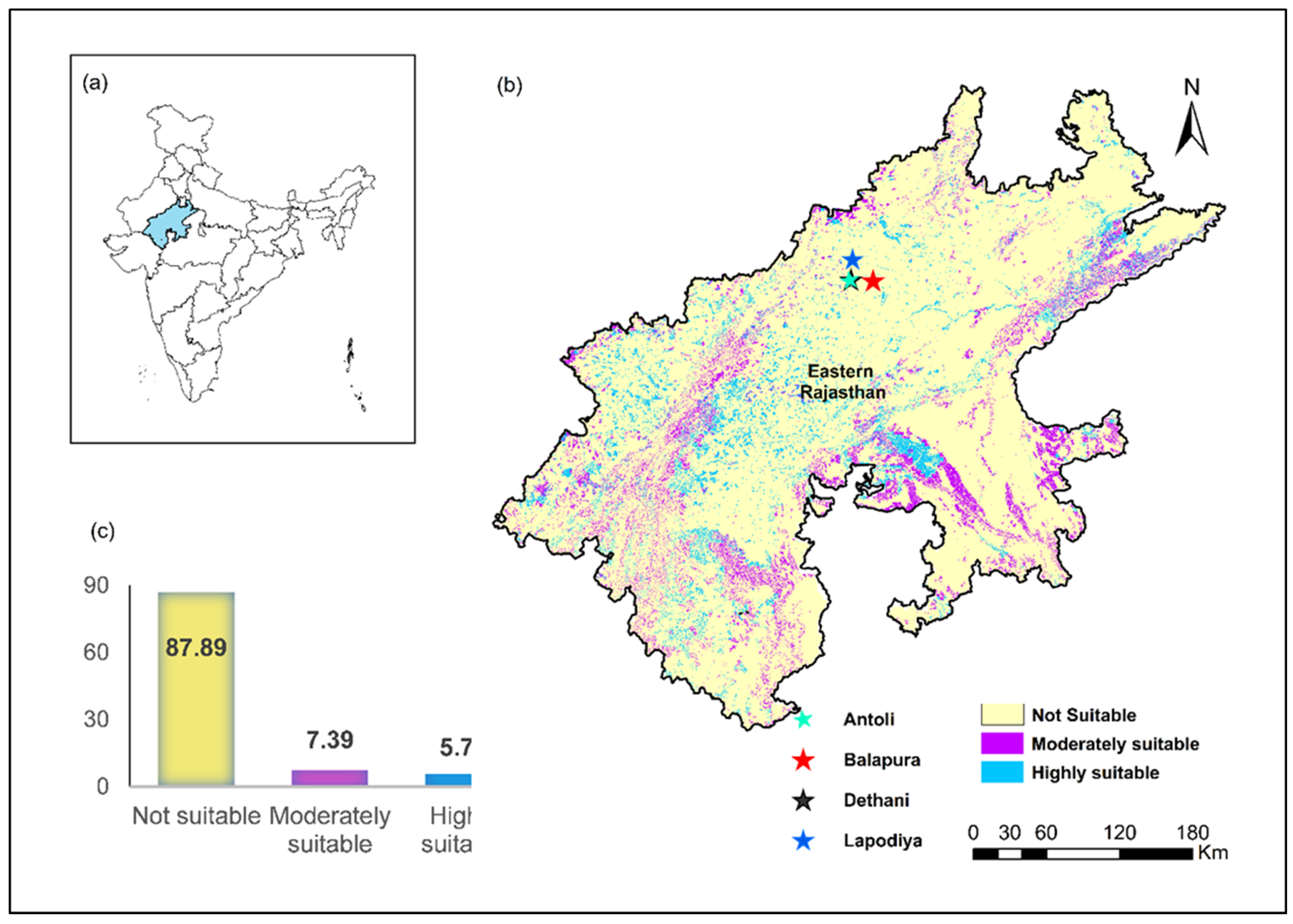
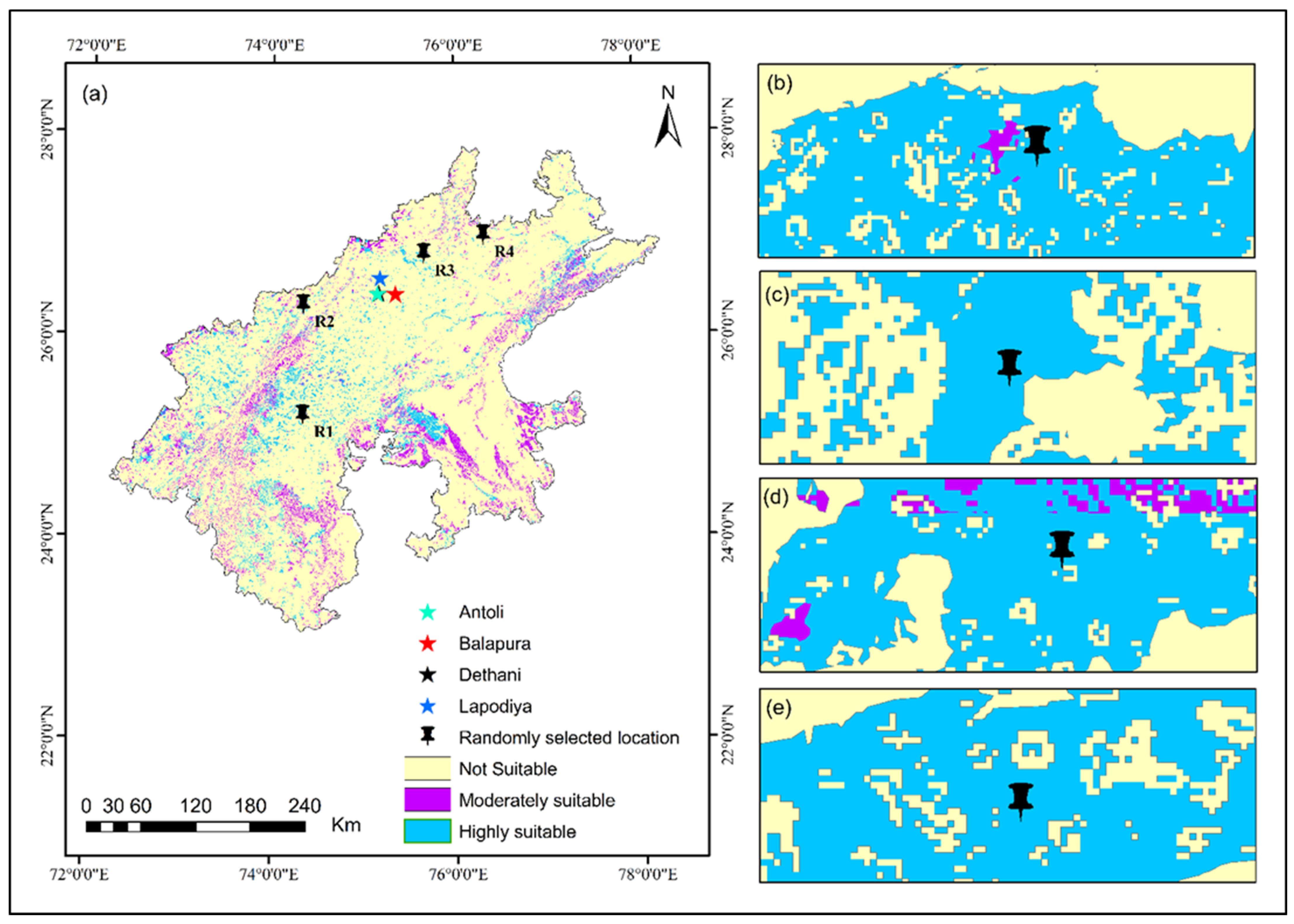
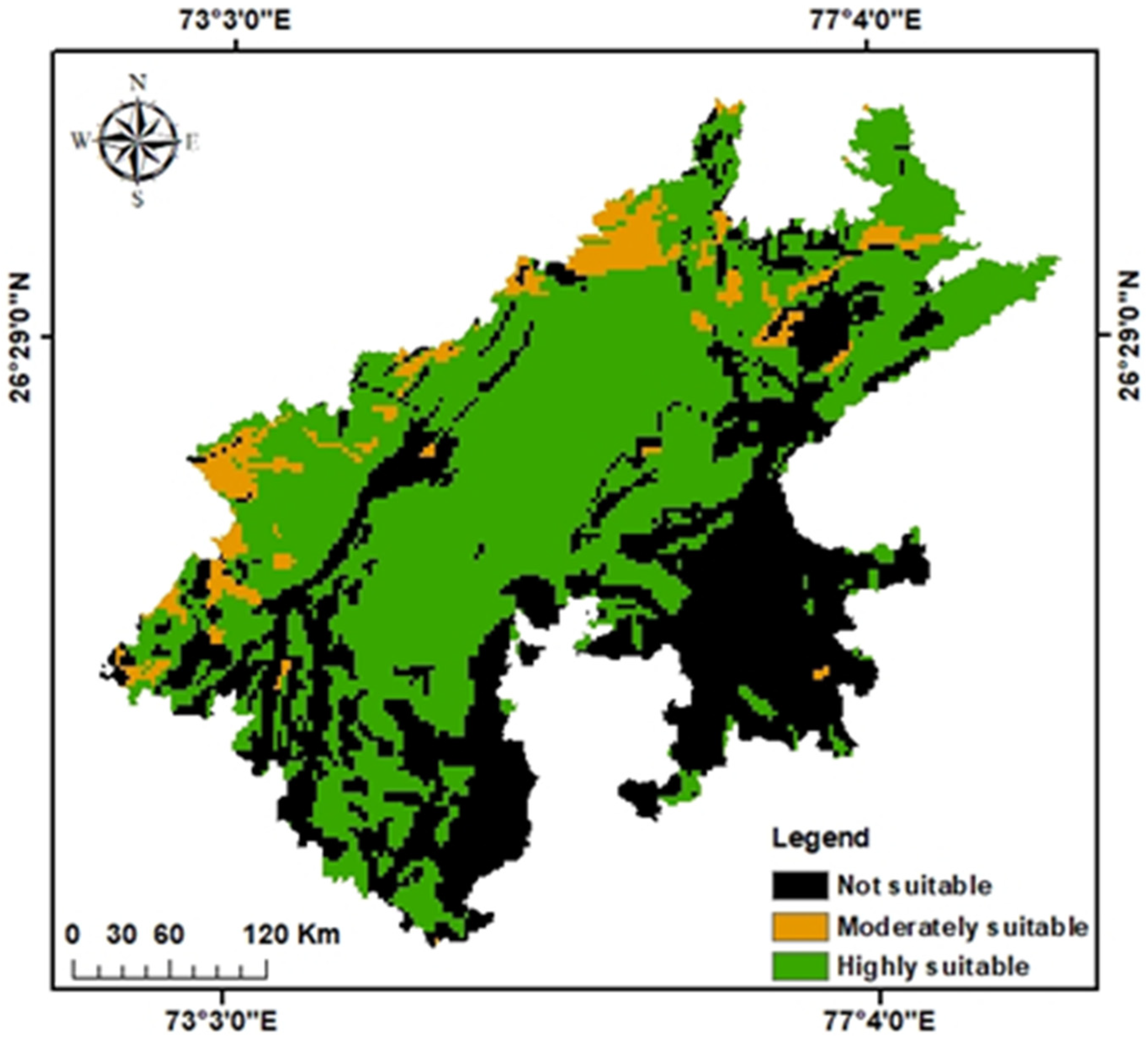
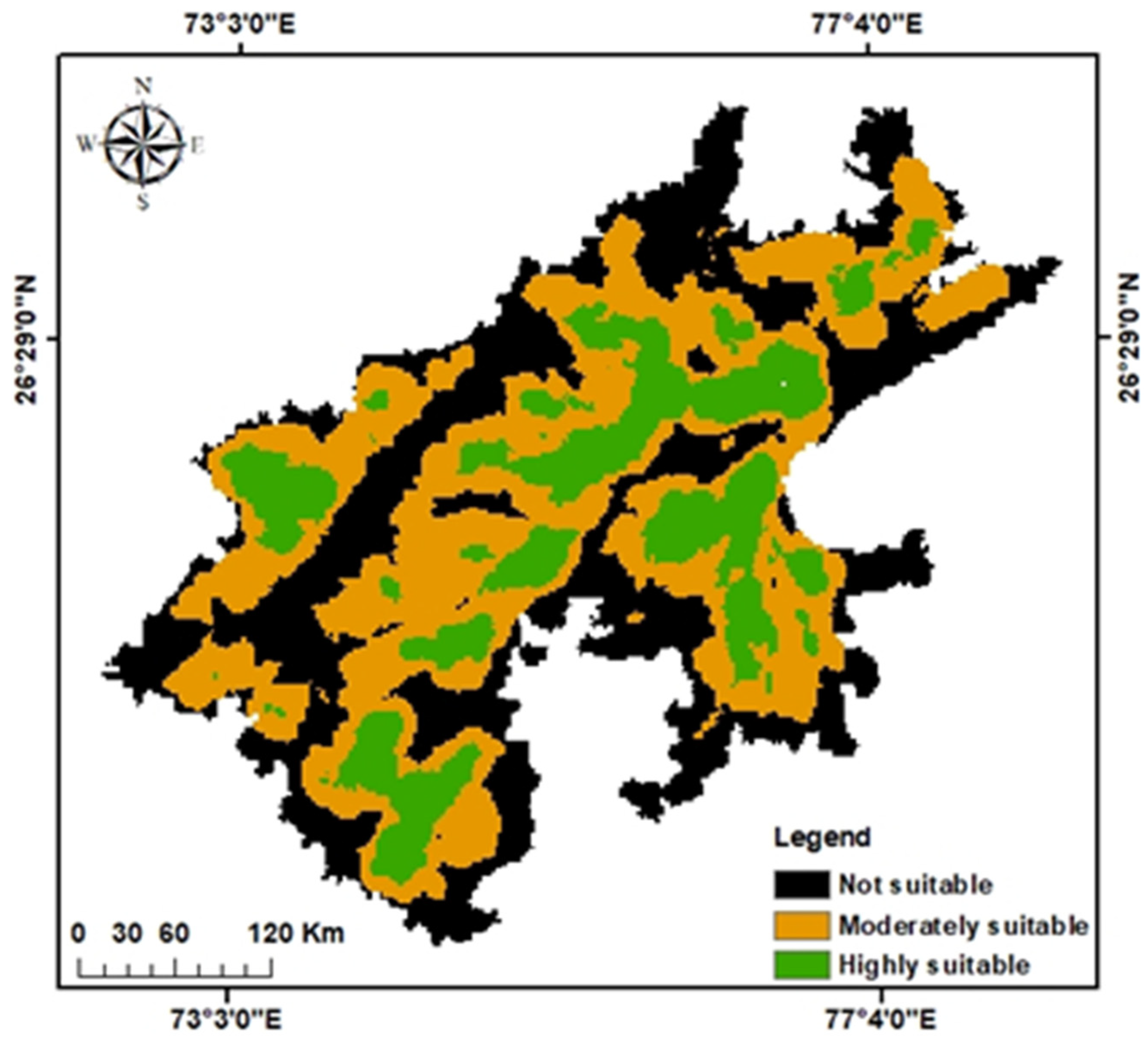
3.1. Identification of Potential Chauka Sites

This study processed six thematic layers using a GIS-integrated multicriteria decision-making approach to identify suitable locations for the Chauka system. The six criteria layers (Appendix A) were combined, considering corresponding weights and feature classes, resulting in the RWH suitability map (Figure 3). The suitability map was categorized into three classes: unsuitable, moderately suitable, and highly suitable. Depending on the study’s objectives and the requirements of decision makers and water resource planners, subdivisions into further classes could be made. The site suitability map shows the spatial distribution of potential sites suitable for Chauka construction. Around 7515 km2 (5.6% of the study area) is considered to be highly suitable, 9886 km2 (7.4%) is moderately suited, and 116,350 km2 (86.9%) is unsuited. Figure 3 shows that most areas fall in the moderately (orange) and unsuited (light orange) categories. The highly suitable RWH sites are spread across the study area, particularly in the western region of Rajasthan.

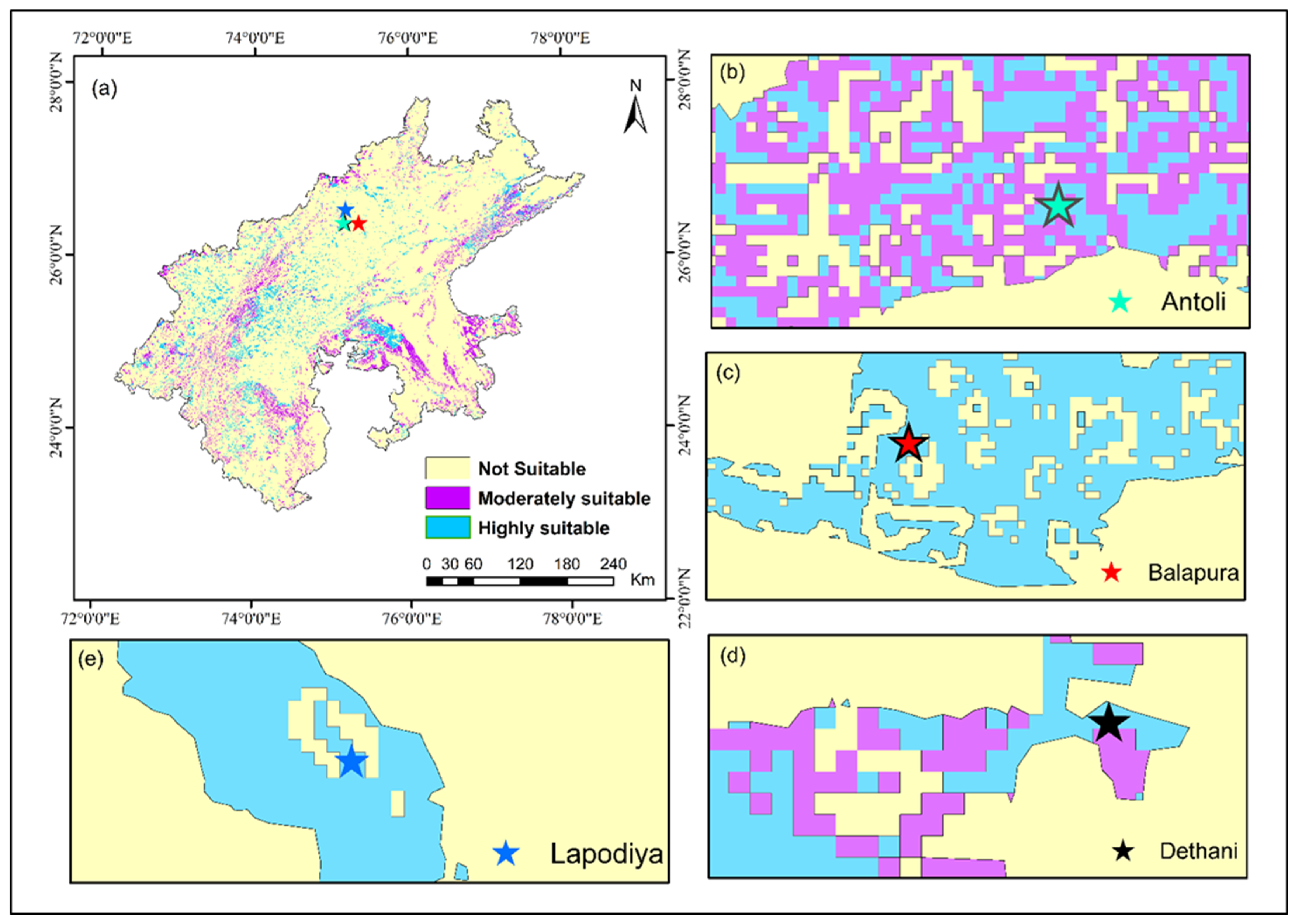
3.2. Validation of Identified Suitable Sites

The coordinates of sites where Chaukas had been constructed were obtained from GVNML and superimposed on the suitability map (Figure 4). All four Chauka locations were classified as being highly suitable. Figure 5 shows randomly selected sites from highly and moderately suitable areas that share similar identified criteria. Location R3 has sandy soil, while the remaining areas have loamy soil textures. All the randomly selected sites fall within the scrubland and barren land for land use and land cover having a slope between 0–3% except location 3. Location 4 receives 576 mm rainfall, while location 3 receives 457 mm rainfall and has a 3–7% slope. Location 2 receives 592 mm rainfall, and location 1 receives 456 mm rainfall and has a 2–3% slope. Therefore, these randomly selected locations fully met the predetermined criteria.

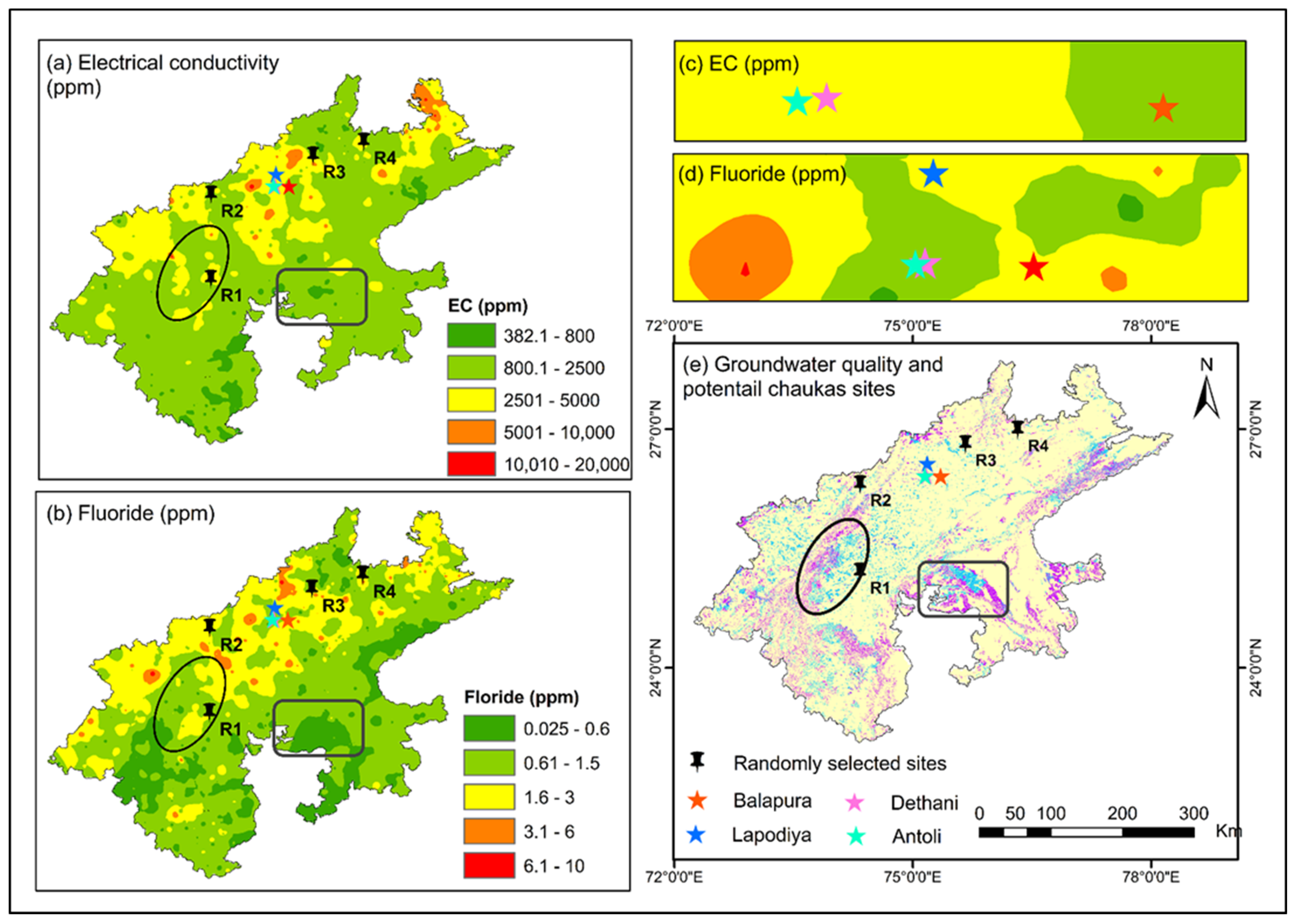
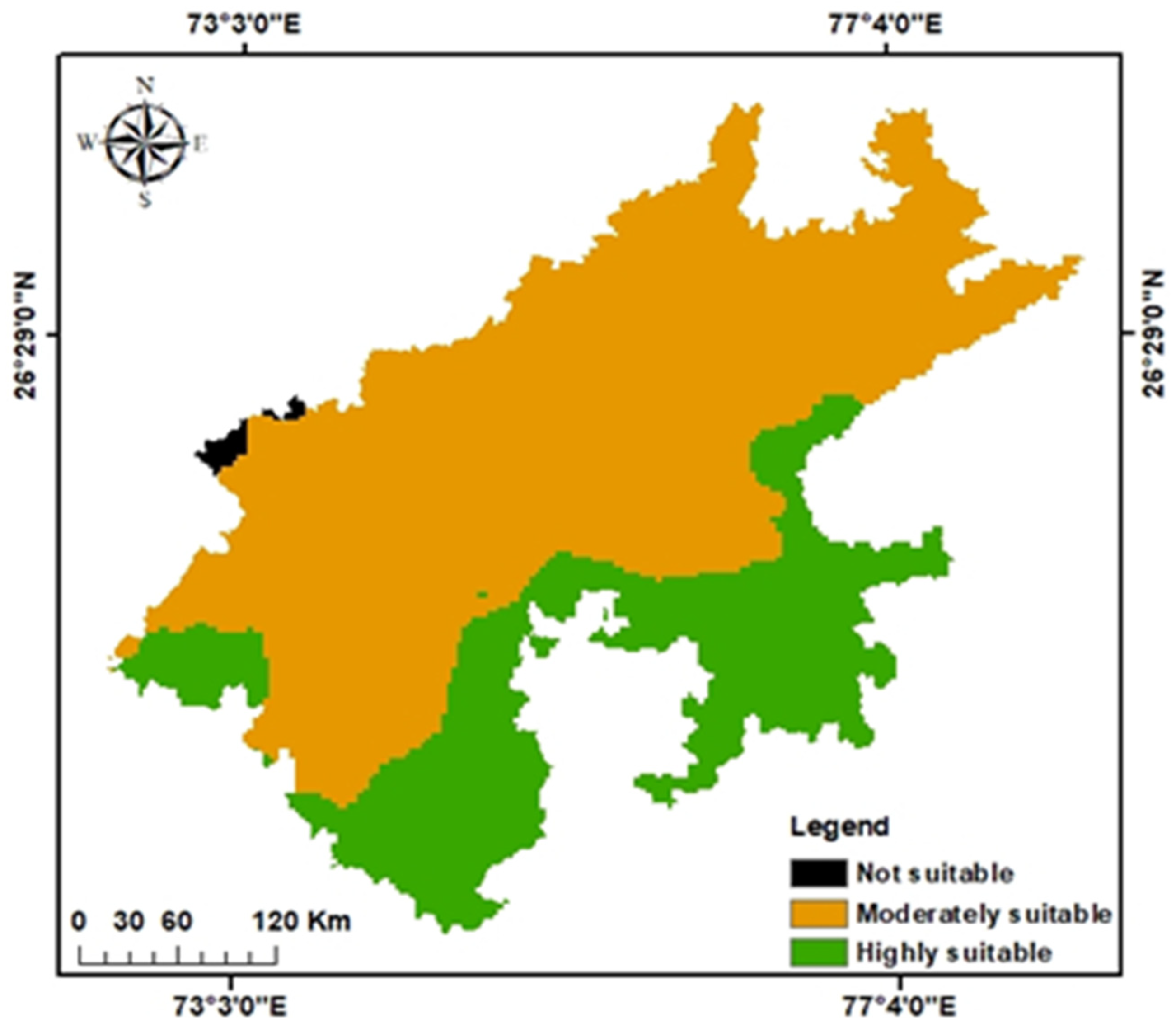
3.3. Evaluation of RWH Sites for Identifying the Environmental Impact of Chauka Sites

Water quality plays a vital role in sustaining an ecosystem and community. However, depending on their size and location, RWH structures may contain various toxic elements. Recently, it was observed that in some areas, the value of the GW quality parameters exceeded allowable limits due to geogenic contaminants (fluoride and arsenic) and anthropogenic activities (overuse of fertilizer, septic systems, mishandling of industrial chemicals, mining, landfills, animal wastes, and road runoff) which introduced contaminants including nitrate, biological contaminants (coliform bacteria), and heavy metals (uranium, cadmium, arsenic, etc.) [53,54,55]. Thus, contaminants generated by anthropogenic activities might get into the RWH structures and further increase sedimentation and mineral concentration in the GW, which increases the EC value over time [15,56,57,58]. However, GW is a significant source of irrigation in (semi-) arid regions. If contaminated water is used, then there is a high probability of accumulation over time due to low rainfall and poor soil structure. The author of [55] assessed the suitability of the GW for irrigation use by integrating EC, Na+, Cl HCO3−, and SAR in a semi-arid district (Birbhum) of India and reported that 97.73–98.88% of the area is moderate to severely unsuitable for irrigation. Furthermore, they stated that irrigated areas with such bad water quality result in poor soil structure formation, causing impermeability of the soil, directly affecting crop growth, and limiting the choice of crops for cultivation. Site-specific approaches should be taken to understand the impact of recharge water on GW quality and the use of contaminated GW for human consumption or irrigation.
To ensure Chauka recharge sites are appropriate, it is necessary to consider the current status of GW quality for community use. Electrical conductivity measures water’s capacity to convey electric current, while fluoride is a crucial micronutrient that supports healthy teeth and bones in humans. In Rajasthan, major health concerns arise from elevated fluoride levels in the GW [59,60]. In groundwater, the WHO’s acceptable limit for fluoride is 1.5 mg/L, and the most desirable limit of EC in drinking water is prescribed as 1500 µS/cm [61]. In our analysis, 1556 data points were considered and interpolated with the IWD method, reflecting the 18-year average GW quality. Based on the permitted EC limits for drinking water for human and livestock consumption and irrigation water, the region’s EC value was classified into five categories (a) 382–800 ppm, (b) 800–2500 ppm, (c) 2501–5000 ppm, (d) 5001–10,000 ppm, and (e) >10,000 ppm (Figure 6a). Fluoride concentrations in the area were classified based on associated health risks given by [62], which are (a) 0–0.6 ppm, (b) 0.61–1.5 ppm, (c) 1.6–3.0 ppm, (d) 3.1–6.0 ppm, and (e) >6.0 ppm as shown in Figure 6b. The generated maps were superimposed on the existing and identified Chaukas’ suitable locations to reflect the status of GW quality. Figure 6c highlights that most of the existing Chauka sites’ EC values range between 2500–5000 ppm except for Balapura (800–2500 ppm). In addition, EC concentrations in randomly selected locations (R1 and R3) range between 2500 and 3000 ppm, while R2 and R4 range between 800 and 2500 ppm. Fluoride concentrations in Antoli and Dethani are within acceptable ranges (0.6–1.5 ppm), while Lapodiya and Balapura have slightly higher concentrations (1.5–3.0 ppm). Fluoride concentrations in randomly selected locations (R1 and R2) are between 0.61–1.5 ppm, while in (R3 and R4) they range between 1.6–6.0 ppm. Furthermore, most of the highly and moderately suitable Chauka construction sites are found in the southern and western parts of the study area with acceptable fluoride and EC concentrations. However, the authors of [63] have developed mitigation strategies for fluoride release during recharge events through MAR structures in western Australia. They reported that the release of fluoride from aquifer materials depends on site-specific conditions such as source water quality and the presence of other minerals in aquifer materials. Thus, a better understanding of the GW quality at Chauka sites can improve operational conditions for meeting water demands, thereby extending the benefits of existing Chauka schemes. Authorities and users will be able to set priorities for protecting the environment and population according to the scope and severity of the contamination.

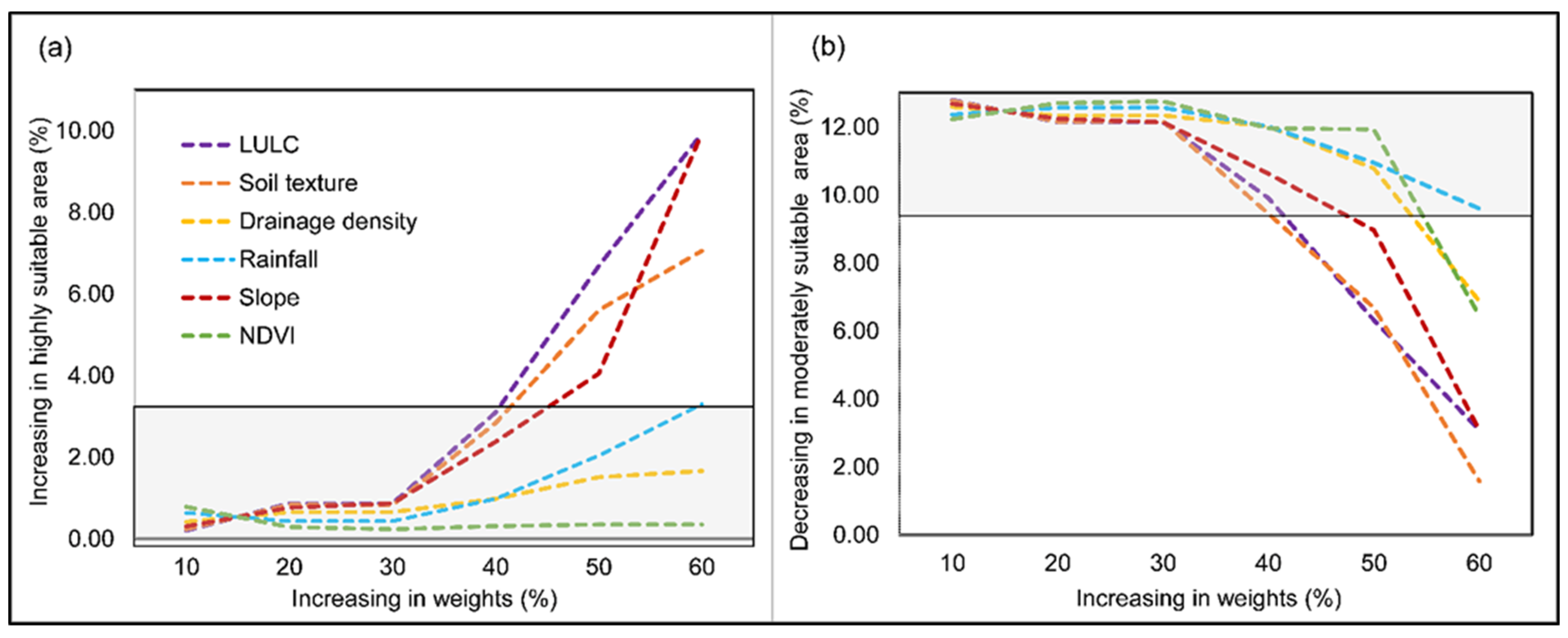
3.4. Sensitivity Analysis

In sensitivity analysis, we notice that some parameters, such as LULC, slope, and soil texture, change more rapidly than others with increasing weights and are more likely to decide the outcome (Figure 7). Sensitivity can be observed by comparing the slope lines of each parameter. A high degree of sensitivity was found in the LULC parameter for the highly suitable area, followed by slope, soil texture, rainfall, drainage density, and NDVI. The weight increase from 10 to 60% increased the highly suitable area from 0.20% to 9.93%. However, NDVI was the most insensitive parameter, followed by drainage density and rainfall, as increasing their weights does not significantly increase in highly suitable areas. Similarly, the result of a moderately suitable area shows that the soil texture is the main parameter, followed by LULC and slope.

4. Discussion

Considering GIS-based MCDA, various studies have identified the potential sites for GW potential zones [29,30,64], managed aquifer recharge sites [65,66,67], and RWH structures [5,27,68,69]. However, several lack the consideration of structure-specific information, stakeholder consideration, and local expertise. The present study identified and weighted relevant criteria for Chauka implementation. The criteria and their significance for Chauka implementation were considered upon a literature survey, field visits, and practitioners’ experience. Based on the relevant criteria, this study presents a transferable and practical framework for identifying potential areas for Chauka implementation in the Rajasthan state of India.
We identified potential sites for scaling up traditional RWH structures like Chaukas in Rajasthan using the GIS-based MCDA. Author [64] used AHP and multi-influencing factors to identify the GW potential zone in the Jaipur district of western Rajasthan and found that 13%, 50.7%, and 36.3% of the district are highly suitable, moderately suitable, and unsuitable, respectively. Additionally, [18] carried out a similar kind of study in Semi-arid regions of Rajasthan and found that out of 12,698 km2, only 17% are categorized as a good GW potential zone. While other classes, such as moderate, poor, and very poor, comprised 29%, 36%, and 18%, respectively. The author of [70] also identified potential sites for water harvesting structures in the Gadela watershed of Udaipur district (Rajasthan). They stated that 45% of the region is moderately suitable, followed by 31% and 24% is highly suitable and less suitable, respectively. This study’s weight, assigned to various parameters, was based on the existing Chauka sites. Hence, out of the total area of Rajasthan (342,239 km2), only 3.61% (12,320 km2) area is in the highly suitable category, while 28,063.60 km2 (8.20%) is in moderately suitable zones for Chauka implementation, and the rest of the site is in the unsuitable zone.
To scale up the existing MAR schemes across a larger area, it is imperative that sites identified using the GIS-MCDA approach should be validated. However, no direct methods exist to verify MAR-suitable sites, so indirect methods must be applied. Many studies [71,72] have used the existing MAR projects to validate their site selection. Recently, a study [32] used the water level fluctuation method to validate the selected sites for MAR structures. In this study, the suitable Chauka sites were validated using the existing Chauka sites at four different locations. Further, randomly handpicked sites from highly and moderately suitable areas were also evaluated and validated against the designed criteria for the Chaukas. The existing Chauka systems at Antoli, Dethani, Balapura, and Lapodiya were classified as highly suitable. Further, the randomly handpicked highly suitable sites also have similar field conditions as found in the already functioning Chauka sites.
GW quality of surrounding areas and transportation facilities for regular maintenance should be considered when prioritizing RWH structures [15]. Various studies have reported the occurrence of high fluoride and EC contamination [18,59,60,73,74], anthropogenic (nitrate) contaminants in GW [59,75,76], and heavy metal accumulations in soil over time in various patches of Rajasthan [77,78]. By comparing the 18 years’ average GW quality generated IWD interpolated map with the Chauka site suitability map, we considered two majorly reported GW quality problems in Rajasthan state: elevated fluoride and EC. The Rapid Assessment of Wetland Ecosystem Services (RAWES) approach was used by the authors of [15] to study the influence of Chaukas on water availability and related ecosystem services in two villages of Rajasthan, Antoli (in which the Chaukas were constructed after 2018) and Laporiya (in which the Chaukas had been present since 1987). They reported the significant difference in the Environmental Sustainability Index (ESI) scores in all the services for both villages and stated that Laporiya has higher scores due to the engagement of the whole community and their collaborative work to achieve water and livelihood security. A significant factor in choosing a site for Chauka implementation is how far it is from the main road. Existing road networks can provide better connectivity between local stakeholders and Chauka sites, which can help with operation and maintenance.
The site suitability map for Chauka implementation was based on a methodology that can be used for effective management, micro-level planning, and implementation of Chauka as an indigenous RWH system in the study area. The site suitability map suggests the potential sites that can be considered for the Chauka construction in various parts of the study region. Site-specific evaluations for different MAR schemes using detailed modeling should be considered to assess their impact on surrounding ecosystems. Further, among the criteria selected, historical rainfall and current land use/land cover pattern data were used without considering the effect of climate change, which may vary in the future and hence should be considered in the detailed analysis. Nevertheless, we identified potential Chauka sites in Rajasthan. Further research should focus on its upscaling using additional information such as acceptance among locals and funding requirements for their training and awareness program (about benefits, distribution of water share) for long-term sustainability.

5. Conclusions

Under the threat of climate change and water scarcity, traditional RWH systems need to be scaled up. This system captures the rainwater for multiple benefits, including increasing water demands and constrained supply in Rajasthan’s arid and semi-arid regions. Our study aims to develop a methodology to scale up one of the traditional RWH systems of Rajasthan, called Chaukas, to identify the potential RWH sites in Rajasthan (India). This study combined remote sensing and field data in a GIS-based MCDA to determine the suitability of different locations for the Chauka system in the study area. First, spatial datasets relating to land use/cover, rainfall, slope, soil texture, NDVI, and drainage density were defined as assessment criteria. Each was weighted based on their relative importance to RWH with expert opinions. The results indicated that only 3.6% of the total area is considered to be highly suitable for Chauka construction, 8.2% is moderately suitable, and 27.3% is unsuited. The methodology incorporated biophysical parameters (slope, land use, land cover, soil type, and rainfall) into the selection process to build long-term treatments that improve groundwater recharge in arid environments. Overall, our study shows the applicability of the MCDA approach for the expansion of the traditional RWH system, and the approach can be used in a similar arid and semi-arid climates where rainwater collection might benefit local communities and improve livelihoods. Planners and water resources engineers can benefit from the suitability mapping approach to implement rainwater harvesting programs in regions with similar climatic conditions. However, the future studies must include variability of land use and rainfall pattern under changing climate, impact on water quality, acceptance among locals, and funding requirements for their training and awareness program for long-term sustainability.

Author Contributions

A.R.: data collection, data curation, methodology, formal analysis, writing—original draft., N.P.: methodology, formal analysis, writing—review, editing, B.Y.: conceptualization, funding acquisition, project administration, methodology, supervision, writing—review, editing, K.J.: formal analysis, visualization, writing—review, editing, M.P.M.: formal analysis, writing—review, editing, A.K.: formal analysis, writing—review, editing; J.W.K.: formal analysis, writing—review, and editing. All authors have read and agreed to the published version of the manuscript.

Funding

The research was funded by Asia-Pacific Network for Global Change Research (CBA2021-06SY-Yadav) and NERC grant (NER-1790-WRC) to the corresponding author.

Data Availability Statement

Data will be provided by the corresponding author upon request.

Acknowledgments

The authors acknowledge the support provided by Alison Parker, Cranfield University in conducting this research. The authors also acknowledge Jagveer Singh, Gram Vikas Navyuvak Mandal Laporiya, for his assistance in providing information on Chaukas.

Conflicts of Interest

The authors declare no competing interests.

Appendix A

Figure A1. Reclassified soil texture map of study area.
Water 15 02042 g0a1
Figure A2. Reclassified slope map of study area.
Water 15 02042 g0a2
Figure A3. Reclassified LULC map of study area.
Water 15 02042 g0a3
Figure A4. Reclassified annual average rainfall map of study area.
Water 15 02042 g0a4
Figure A5. Reclassified NDVI map of study area.
Water 15 02042 g0a5
Figure A6. Reclassified drainage density map of study area.
Water 15 02042 g0a6

References

  1. Contreras, S.M.; Sandoval, T.S.; Tejada, S.Q. Rainwater Harvesting, Its Prospects and Challenges in the Uplands of Talugtog, Nueva Ecija, Philippines. Int. Soil Water Conserv. Res. 2013, 1, 56–67. [Google Scholar] [CrossRef]
  2. Haile Wondimu, G.; Shiferaw Jote, D. Selection of Rainwater Harvesting Sites by Using Remote Sensing and GIS Techniques: A Case Study of Dawa Sub Basin Southern Ethiopia. Am. J. Mod. Energy 2020, 6, 84. [Google Scholar] [CrossRef]
  3. Boretti, A.; Rosa, L. Reassessing the Projections of the World Water Development Report. npj Clean Water 2019, 2, 15. [Google Scholar] [CrossRef]
  4. Ziadat, F.; Bruggeman, A.; Oweis, T.; Haddad, N.; Mazahreh, S.; Sartawi, W.; Syuof, M. A Participatory GIS Approach for Assessing Land Suitability for Rainwater Harvesting in an Arid Rangeland Environment. Arid L. Res. Manag. 2012, 26, 297–311. [Google Scholar] [CrossRef]
  5. Adham, A.; Riksen, M.; Ouessar, M.; Ritsema, C.J. A Methodology to Assess and Evaluate Rainwater Harvesting Techniques in (Semi-) Arid Regions. Water 2016, 8, 198. [Google Scholar] [CrossRef]
  6. Al-Adamat, R.; AlAyyash, S.; Al-Amoush, H.; Al-Meshan, O.; Rawajfih, Z.; Shdeifat, A.; Al-Harahsheh, A.; Al-Farajat, M. The Combination of Indigenous Knowledge and Geo-Informatics for Water Harvesting Siting in the Jordanian Badia. J. Geogr. Inf. Syst. 2012, 4, 366–376. [Google Scholar] [CrossRef]
  7. Machiwal, D.; Jha, M.K.; Singh, P.K.; Mahnot, S.C.; Gupta, A. Planning and Design of Cost-Effective Water Harvesting Structures for Efficient Utilization of Scarce Water Resources in Semi-Arid Regions of Rajasthan, India. Water Resour. Manag. 2004, 18, 219–235. [Google Scholar] [CrossRef]
  8. Mugo, G.M.; Odera, P.A. Site Selection for Rainwater Harvesting Structures in Kiambu County-Kenya. Egypt. J. Remote Sens. Sp. Sci. 2019, 22, 155–164. [Google Scholar] [CrossRef]
  9. Al-Adamat, R. GIS as a Decision Support System for Siting Water Harvesting Ponds in the Basalt Aquifer/NE Jordan. J. Environ. Assess. Policy Manag. 2008, 10, 189–206. [Google Scholar] [CrossRef]
  10. Aziz, S.F.; Abdulrahman, K.Z.; Ali, S.S.; Karakouzian, M. Water Harvesting in the Garmian Region (Kurdistan, Iraq) Using GIS and Remote Sensing. Water 2023, 15, 507. [Google Scholar] [CrossRef]
  11. Radwan, F.; Ali, A. Suitable Sites Identification for Potential Rainwater Harvesting (PRWH) Using a Multi—Criteria Decision Support System (MCDSS). Acta Geophys. 2023, 71, 449–468. [Google Scholar] [CrossRef]
  12. Murugesan, A. Traditional Water Harvesting Systems of Rajasthan. In Ecological Traditions of India; Krishna, N., Singh, A., Eds.; C.P.R. Environmental Education Centre: Chennai, India, 2017; ISBN 978-81-86901-21-2. Available online: https://www.researchgate.net/publication/312799247_Traditional_Water_harvesting_systems_of_Rajasthan (accessed on 20 May 2023).
  13. CARRIERE, M. Impact of Rainwater Harvesting in Rural Rajasthan: An Assessment. Master’s Thesis, School of Water, Energy and Environment, Cranfield University, Cranfield, UK, 2018. Available online: https://www.gvnml.org/wp-content/uploads/2021/03/Thesis-CARRIERE.pdf (accessed on 20 May 2023).
  14. Yadav, B.; Patidar, N.; Sharma, A.; Panigrahi, N.; Sharma, R.K.; Loganathan, V.; Krishan, G.; Singh, J.; Kumar, S.; Parker, A. Assessment of Traditional Rainwater Harvesting System in Barren Lands of a Semi-Arid Region: A Case Study of Rajasthan (India). J. Hydrol. Reg. Stud. 2022, 42, 101149. [Google Scholar] [CrossRef]
  15. Everard, M.; West, H. Livelihood Security Enhancement Though Innovative Water Management in Dryland India. Water Int. 2021, 46, 59–82. [Google Scholar] [CrossRef]
  16. de Winnaar, G.; Jewitt, G.P.W.; Horan, M. A GIS-Based Approach for Identifying Potential Runoff Harvesting Sites in the Thukela River Basin, South Africa. Phys. Chem. Earth 2007, 32, 1058–1067. [Google Scholar] [CrossRef]
  17. Preeti, P.; Shendryk, Y.; Rahman, A. Identification of Suitable Sites Using GIS for Rainwater Harvesting Structures to Meet Irrigation Demand. Water 2022, 14, 3480. [Google Scholar] [CrossRef]
  18. Machiwal, D.; Jha, M.K.; Mal, B.C. Assessment of Groundwater Potential in a Semi-Arid Region of India Using Remote Sensing, GIS and MCDM Techniques. Water Resour. Manag. 2011, 25, 1359–1386. [Google Scholar] [CrossRef]
  19. Yeh, H.F.; Cheng, Y.S.; Lin, H.I.; Lee, C.H. Mapping Groundwater Recharge Potential Zone Using a GIS Approach in Hualian River, Taiwan. Sustain. Environ. Res. 2016, 26, 33–43. [Google Scholar] [CrossRef]
  20. Salar, S.G.; Othman, A.A.; Hasan, S.E. Identification of Suitable Sites for Groundwater Recharge in Awaspi Watershed Using GIS and Remote Sensing Techniques. Environ. Earth Sci. 2018, 77, 701. [Google Scholar] [CrossRef]
  21. Waghaye, A.M.; Singh, D.K.; Sarangi, A.; Sena, D.R.; Sahoo, R.N.; Sarkar, S.K. Identification of Suitable Zones and Sites for Rainwater Harvesting Using GIS and Multicriteria Decision Analysis. Environ. Monit. Assess. 2023, 195, 279. [Google Scholar] [CrossRef] [PubMed]
  22. Gebre, S.L.; Cattrysse, D.; Van Orshoven, J. Multi-Criteria Decision-Making Methods to Address Water Allocation Problems: A Systematic Review. Water 2021, 13, 125. [Google Scholar] [CrossRef]
  23. Mengistu, T.D.; Chang, S.W.; Kim, I.; Kim, M.; Chung, I. Determination of Potential Aquifer Recharge Zones Using Geospatial Techniques for Proxy Data of Gilgel Gibe. Water 2022, 14, 1362. [Google Scholar] [CrossRef]
  24. Jenifer, M.A.; Jha, M.K. A Novel GIS-Based Modeling Approach for Evaluating Aquifer Susceptibility to Anthropogenic Contamination. Sustainability 2022, 14, 4538. [Google Scholar] [CrossRef]
  25. Khan, A.; Govil, H.; Taloor, A.K.; Kumar, G. Identification of Artificial Groundwater Recharge Sites in Parts of Yamuna River Basin India Based on Remote Sensing and Geographical Information System. Groundw. Sustain. Dev. 2020, 11, 100415. [Google Scholar] [CrossRef]
  26. IGRAC Artificial Recharge of Groundwater in the World. Int. Groundw. Resour. Assess. Cent. 2007, 1–92.
  27. Shadmehri Toosi, A.; Ghasemi Tousi, E.; Ghassemi, S.A.; Cheshomi, A.; Alaghmand, S. A Multi-Criteria Decision Analysis Approach towards Efficient Rainwater Harvesting. J. Hydrol. 2020, 582, 124501. [Google Scholar] [CrossRef]
  28. Balkhair, K.S.; Ur Rahman, K. Development and Assessment of Rainwater Harvesting Suitability Map Using Analytical Hierarchy Process, GIS and RS Techniques. Geocarto Int. 2021, 36, 421–448. [Google Scholar] [CrossRef]
  29. Nasiri, H.; Boloorani, A.D.; Sabokbar, H.A.F.; Jafari, H.R.; Hamzeh, M.; Rafii, Y. Determining the Most Suitable Areas for Artificial Groundwater Recharge via an Integrated PROMETHEE II-AHP Method in GIS Environment (Case Study: Garabaygan Basin, Iran). Environ. Monit. Assess. 2013, 185, 707–718. [Google Scholar] [CrossRef]
  30. Arulbalaji, P.; Padmalal, D.; Sreelash, K. GIS and AHP Techniques Based Delineation of Groundwater Potential Zones: A Case Study from Southern Western Ghats, India. Sci. Rep. 2019, 9, 2082. [Google Scholar] [CrossRef] [PubMed]
  31. Russo, T.A.; Fisher, A.T.; Lockwood, B.S. Assessment of Managed Aquifer Recharge Site Suitability Using a GIS and Modeling. Groundwater 2015, 53, 389–400. [Google Scholar] [CrossRef] [PubMed]
  32. Fuentes, I.; Vervoort, R.W. Site Suitability and Water Availability for a Managed Aquifer Recharge Project in the Namoi Basin, Australia. J. Hydrol. Reg. Stud. 2020, 27, 100657. [Google Scholar] [CrossRef]
  33. Central Ground Water Board. Ground Water Year Book, Rajasthan. 2022. Available online: http://cgwb.gov.in/Regions/WR/Reports/GWY%20Book%20Rajasthan%202021-22%20English.pdf (accessed on 20 May 2023).
  34. Sharma, S.K.; Sharma, D.P.; Sharma, M.K.; Gaur, K.; Manohar, P. Trend Analysis of Temperature and Rainfall of Rajasthan, India. J. Probab. Stat. 2021, 2021, 6296709. [Google Scholar] [CrossRef]
  35. Mehta, D.J.; Yadav, S.M. Long-Term Trend Analysis of Climate Variables for Arid and Semi-Arid Regions of an Indian State Rajasthan. Int. J. Hydrol. Sci. Technol. 2022, 13, 191–214. [Google Scholar] [CrossRef]
  36. Critchley, W.; Siegert, K.; Chapman, C.; Finkel, M. Water Harvesting. A Manual for the Design and Construction of Water Harvesting Schemes for Plant Production; Scientific Publishers: Jodhpur, India, 2013; ISBN 978-81-7233-801-5. [Google Scholar]
  37. Kahinda, J.M.; Lillie, E.S.B.; Taigbenu, A.E.; Taute, M.; Boroto, R.J. Developing Suitability Maps for Rainwater Harvesting in South Africa. Phys. Chem. Earth 2008, 33, 788–799. [Google Scholar] [CrossRef]
  38. Khudhair, M.A.; Sayl, K.N.; Darama, Y. Locating Site Selection for Rainwater Harvesting Structure Using Remote Sensing and GIS. IOP Conf. Ser. Mater. Sci. Eng. 2020, 881, 012170. [Google Scholar] [CrossRef]
  39. ICAR-NBSS & LUP. Available online: https://nbsslup.icar.gov.in/about-institute/ (accessed on 25 February 2023).
  40. Mahnot, S.C.; Singh, P.K.; Chaplot, P.C. Chauka System–An Innovative Technique. Soil and Water Conservation and Watershed Management; Apex Publishing House: Udaipur, India, 2012; ISBN 9788130100739; 8130100738. [Google Scholar]
  41. Ibrahim, G.R.F.; Rasul, A.; Hamid, A.A.; Ali, Z.F.; Dewana, A.A. Suitable Site Selection for Rainwater Harvesting and Storage Case Study Using Dohuk Governorate. Water 2019, 11, 864. [Google Scholar] [CrossRef]
  42. U.S. Environmental Protection Agency (USEPA). Storm Water Technology Fact Sheet. In Fact Sheet; EPA: Washington, DC, USA, 1999; Volume 7. [Google Scholar]
  43. Kadam, A.K.; Kale, S.S.; Pande, N.N.; Pawar, N.J.; Sankhua, R.N. Identifying Potential Rainwater Harvesting Sites of a Semi-Arid, Basaltic Region of Western India, Using SCS-CN Method. Water Resour. Manag. 2012, 26, 2537–2554. [Google Scholar] [CrossRef]
  44. Kadam, A.; Kale, S.; Umrikar, B.; Sankhua, R.; Pawar, N. Identifying Possible Locations to Construct Soil Water Conservation Structures by Using Hydrogeological and Geospatial Analysis. Hydrospatial. Anal. 2017, 1, 18–27. [Google Scholar] [CrossRef]
  45. Selvam, S.; Sivasubramanian, P. Groundwater potential zone identification using geoelectrical survey: A case study from Medak district, Andhra Pradesh, India. Int. J. Geomat. Geosci. 2012, 3, 55–62. [Google Scholar]
  46. Ammar, A.; Riksen, M.; Ouessar, M.; Ritsema, C. Identification of Suitable Sites for Rainwater Harvesting Structures in Arid and Semi-Arid Regions: A Review. Int. Soil Water Conserv. Res. 2016, 4, 108–120. [Google Scholar] [CrossRef]
  47. Garg, K.K.; Akuraju, V.; Anantha, K.H.; Singh, R.; Whitbread, A.M.; Dixit, S. Identifying Potential Zones for Rainwater Harvesting Interventions for Sustainable Intensification in the Semi-Arid Tropics. Sci. Rep. 2022, 12, 3882. [Google Scholar] [CrossRef]
  48. Saaty Thomas, L. The Analytic Hierarchy Process; McGraw-Hill International Book Company: New York, NY, USA, 1980; ISBN 978-0070543713; 0070543712. [Google Scholar]
  49. Adamcsek, E. The Analytic Hierarchy Process and Its Generalizations. Thesis, Eotvos Lorand University, Budapest, Hungary, 2008; pp. 1–43. Available online: https://web.cs.elte.hu/blobs/diplomamunkak/alkmat/2008/adamcsek_edit.pdf (accessed on 20 May 2023).
  50. Boroushaki, S.; Malczewski, J. Implementing an Extension of the Analytical Hierarchy Process Using Ordered Weighted Averaging Operators with Fuzzy Quantifiers in ArcGIS. Comput. Geosci. 2008, 34, 399–410. [Google Scholar] [CrossRef]
  51. Haghshenas, E.; Gholamalifard, M.; Mahmoudi, N.; Kutser, T. Developing a Gis-Based Decision Rule for Sustainable Marine Aquaculture Site Selection: An Application of the Ordered Weighted Average Procedure. Sustainability 2021, 13, 2672. [Google Scholar] [CrossRef]
  52. Aghaloo, K.; Chiu, Y.R. Identifying Optimal Sites for a Rainwater-Harvesting Agricultural Scheme in Iran Using the Best-Worst Method and Fuzzy Logic in a GIS-Based Decision Support System. Water 2020, 12, 1913. [Google Scholar] [CrossRef]
  53. Lapworth, D.J.; Boving, T.B.; Kreamer, D.K.; Kebede, S.; Smedley, P.L. Groundwater Quality: Global Threats, Opportunities and Realising the Potential of Groundwater. Sci. Total Environ. 2022, 811, 152471. [Google Scholar] [CrossRef] [PubMed]
  54. Kayastha, V.; Patel, J.; Kathrani, N.; Varjani, S.; Bilal, M.; Show, P.L.; Kim, S.H.; Bontempi, E.; Bhatia, S.K.; Bui, X.T. New Insights in Factors Affecting Ground Water Quality with Focus on Health Risk Assessment and Remediation Techniques. Environ. Res. 2022, 212, 113171. [Google Scholar] [CrossRef] [PubMed]
  55. Mukherjee, I.; Singh, U.K.; Chakma, S. Evaluation of Groundwater Quality for Irrigation Water Supply Using Multi-Criteria Decision-Making Techniques and GIS in an Agroeconomic Tract of Lower Ganga Basin, India. J. Environ. Manage. 2022, 309, 114691. [Google Scholar] [CrossRef]
  56. Varjani, S.J.; Upasani, V.N. Critical Review on Biosurfactant Analysis, Purification and Characterization Using Rhamnolipid as a Model Biosurfactant. Bioresour. Technol. 2017, 232, 389–397. [Google Scholar] [CrossRef]
  57. Rahman, A.; Tiwari, K.K.; Mondal, N.C. Assessment of Hydrochemical Backgrounds and Threshold Values of Groundwater in a Part of Desert Area, Rajasthan, India. Environ. Pollut. 2020, 266, 115150. [Google Scholar] [CrossRef]
  58. Shaji, E.; Santosh, M.; Sarath, K.V.; Prakash, P.; Deepchand, V.; Divya, B.V. Arsenic Contamination of Groundwater: A Global Synopsis with Focus on the Indian Peninsula. Geosci. Front. 2021, 12, 101079. [Google Scholar] [CrossRef]
  59. Suthar, S.; Garg, V.K.; Jangir, S.; Kaur, S.; Goswami, N.; Singh, S. Fluoride Contamination in Drinking Water in Rural Habitations of Northern Rajasthan, India. Environ. Monit. Assess. 2008, 145, 1–6. [Google Scholar] [CrossRef]
  60. Mukherjee, I.; Singh, U.K. Groundwater Fluoride Contamination, Probable Release, and Containment Mechanisms: A Review on Indian Context; Springer: Amsterdam, The Netherlands, 2018; Volume 40, ISBN 0123456789. [Google Scholar]
  61. WHO World Health Organisation. Guidelines for Drinking Water Quality, 3rd ed.; WHO: Geneva, Switzerland, 2004; Volume 1, ISBN 9241546387. Available online: https://www.google.co.in/books/edition/Guidelines_for_Drinking_water_Quality/SJ76COTm-nQC?hl=en&gbpv=1&dq=Guidelines+for+drinking-water+quality,+3rd+edition:+Volume+1+-+Recommendations+incorporating+the+first+and+second+addenda,+2004&pg=PR15&printsec=frontcover (accessed on 20 May 2023).
  62. Kathik, J.; Kathal, P.; Trivedi, R. Fluoride Contamination in Ground Water in a Part of The Tribal Belt in Chhindwara District. Madhya Pradesh, India. Bhu-Jal 2020, Q-7, 27. [Google Scholar]
  63. Schafer, D.; Sun, J.; Jamieson, J.; Siade, A.; Atteia, O.; Seibert, S.; Higginson, S.; Prommer, H. Fluoride Release from Carbonate-Rich Fluorapatite during Managed Aquifer Recharge: Model-Based Development of Mitigation Strategies. Water Res. 2021, 193, 116880. [Google Scholar] [CrossRef] [PubMed]
  64. Yadav, B.; Malav, L.C.; Jangir, A.; Kharia, S.K.; Singh, S.V.; Yeasin, M.; Nogiya, M.; Meena, R.L.; Meena, R.S.; Tailor, B.L.; et al. Application of Analytical Hierarchical Process, Multi-Influencing Factor, and Geospatial Techniques for Groundwater Potential Zonation in a Semi-Arid Region of Western India. J. Contam. Hydrol. 2023, 253, 104122. [Google Scholar] [CrossRef] [PubMed]
  65. Rahman, M.A.; Rusteberg, B.; Gogu, R.C.; Lobo Ferreira, J.P.; Sauter, M. A New Spatial Multi-Criteria Decision Support Tool for Site Selection for Implementation of Managed Aquifer Recharge. J. Environ. Manage. 2012, 99, 61–75. [Google Scholar] [CrossRef]
  66. Sallwey, J.; Bonilla Valverde, J.P.; Vásquez López, F.; Junghanns, R.; Stefan, C. Suitability Maps for Managed Aquifer Recharge: A Review of Multi-Criteria Decision Analysis Studies. Environ. Rev. 2019, 27, 138–150. [Google Scholar] [CrossRef]
  67. Jadav, K.; Yadav, B. Assessing the Suitability of Agricultural Managed Aquifer Recharge (AgMAR) Strategy in the Overexploited and Contaminated Hindon River Basin (HRB), India. In AGU Fall Meeting Abstracts; American Geophysical Union: Washington, DC, USA, 2022. [Google Scholar]
  68. Buraihi, F.H.; Shariff, A.R.M. Selection of Rainwater Harvesting Sites by Using Remote Sensing and GIS Techniques: A Case Study of Kirkuk, Iraq. J. Teknol. 2015, 76, 75–81. [Google Scholar] [CrossRef]
  69. Singh, L.K.; Jha, M.K.; Chowdary, V.M. Multi-Criteria Analysis and GIS Modeling for Identifying Prospective Water Harvesting and Artificial Recharge Sites for Sustainable Water Supply. J. Clean. Prod. 2017, 142, 1436–1456. [Google Scholar] [CrossRef]
  70. Srivalli, C.R.; Singh, M. Identification of Potential Sites for Water Harvesting Structures in Gadela Watershed Using Remote Sensing and GIS. Environ. Conserv. J. 2019, 20, 125–130. [Google Scholar] [CrossRef]
  71. Ghayoumian, J.; Mohseni Saravi, M.; Feiznia, S.; Nouri, B.; Malekian, A. Application of GIS Techniques to Determine Areas Most Suitable for Artificial Groundwater Recharge in a Coastal Aquifer in Southern Iran. J. Asian Earth Sci. 2007, 30, 364–374. [Google Scholar] [CrossRef]
  72. Mahmoud, S.H.; Alazba, A.A.; Amin, M.T. Identification of Potential Sites for Groundwater Recharge Using a GIS-Based Decision Support System in Jazan Region-Saudi Arabia. Water Resour. Manag. 2014, 28, 3319–3340. [Google Scholar] [CrossRef]
  73. Jacks, G.; Bhattacharya, P.; Chaudhary, V.; Singh, K.P. Controls on the Genesis of Some High-Fluoride Groundwaters in India. Appl. Geochem. 2005, 20, 221–228. [Google Scholar] [CrossRef]
  74. Chaudhary, V.; Satheeshkumar, S. Assessment of Groundwater Quality for Drinking and Irrigation Purposes in Arid Areas of Rajasthan, India. Appl. Water Sci. 2018, 8, 218. [Google Scholar] [CrossRef]
  75. Coyte, R.M.; Singh, A.; Furst, K.E.; Mitch, W.A.; Vengosh, A. Co-Occurrence of Geogenic and Anthropogenic Contaminants in Groundwater from Rajasthan, India. Sci. Total Environ. 2019, 688, 1216–1227. [Google Scholar] [CrossRef] [PubMed]
  76. Tanwer, N.; Deswal, M.; Khyalia, P.; Laura, J.S.; Khosla, B. Fluoride and Nitrate in Groundwater: A Comprehensive Analysis of Health Risk and Potability of Groundwater of Jhunjhunu District of Rajasthan, India. Environ. Monit. Assess. 2023, 195, 267. [Google Scholar] [CrossRef]
  77. Krishna, A.K.; Govil, P.K. Heavy Metal Contamination of Soil around Pali Industrial Area, Rajasthan, India. Environ. Geol. 2004, 47, 38–44. [Google Scholar] [CrossRef]
  78. Ray, P.; Datta, S.P.; Dwivedi, B.S. Long-Term Irrigation with Zinc Smelter Effluent Affects Important Soil Properties and Heavy Metal Content in Food Crops and Soil in Rajasthan, India. Soil Sci. Plant Nutr. 2017, 63, 628–637. [Google Scholar] [CrossRef]
Figure 1. Location of the study area showing Rajasthan State in India (a), the location of the district selected for analysis (b), the Chauka system (c), and locations of four existing Chauka sites (d).
Water 15 02042 g001
Figure 2. Conceptual workflow displaying the critical criteria identified as thematic layers and their processing using GIS and AHP to identify potential RWH sites.
Water 15 02042 g002
Figure 3. Eastern area of Rajasthan considered in site suitability analysis (a), RWH suitability map for Chauka construction (b), and data showing suitability class distribution (c).
Water 15 02042 g003
Figure 4. Validation of identified suitable Chauka sites. (a) displays the entire study area, with existing Chauka sites indicated, while panels (be) provide zoomed-in views of specific existing Chauka locations.
Water 15 02042 g004
Figure 5. (a) displays randomly selected potential sites for validation along with existing Chauka sites in the study region; (be) display zoomed-in perspectives of these locations.
Water 15 02042 g005
Figure 6. Maps showing the spatial distribution GW EC across the study area (a), the fluoride concentration in GW distributed over the area (b), zoomed-EC status near the existing Chauka sites (c), fluoride concentration nearby existing Chauka sites (d), and where the majority of the highly suited Chauka sites have safe water quality (e).
Water 15 02042 g006
Figure 7. Model scenario comparison showing changing highly (a) and moderately (b) suitable areas with increasing weights.
Water 15 02042 g007
Table 1. Summary of the key criteria used for evaluating Chauka suitability, including the assigned variables and datasets used for GIS modeling.
CriteriaVariableResolution/ScaleData Source
ClimateRainfall0.25° × 0.25°Indian Meteorological Department https://www.imdpune.gov.in/Clim_Pred_LRF_New/Grided_Data_Download.html (accessed on 22 October 2022)
Hydrology and topographyDrainage density and slope30 mBoth layers are derived from ASTER (DEM with 30 m resolution) https://appeears.earthdatacloud.nasa.gov/task/area (accessed on 06 November 2022)
AgronomyNDVI30 mCalculated using 8 years of Landsat 8 data obtained from google earth engine https://earthengine.google.com (accessed on 14 November 2022)
LULC-202010 m × 10 mESRI Sentinel-2 10 m Land Use/Land Cover https://www.arcgis.com/apps/instant/media/index.html?appid=fc92d38533d440078f17678ebc20e8e2 (accessed on 14 November 2022)
SoilsSoil texture1:250,000Derived by taking reference of National Bureau of Soil Survey and Land Use Planning (NBSS and LUP) data. https://www.arcgis.com/apps/mapviewer/index.html?layers=d6642f8a4f6d4685a24ae2dc0c73d4ac (accessed on 05 December 2022)
Groundwater qualityEC and fluorideN/AGroundwater Authority of India http://cgwb.gov.in/wqreports.html (accessed on 18 January 2023)
InfrastructureRoadsN/AThe main roadways were downloaded from Open Street Map, https://www.openstreetmap.org (accessed on 20 December 2022)
N/A: not applicable
Table 2. A rating scale for pairwise comparison.
Relative ImportanceDegree of Preferences
1Equally
3Moderately
5Strongly
7Very Strongly
9Extremely
2,4,6,8Intermediate
Reciprocals
1/9, 1/7, 1/5, 1/3, 1,3,5,7, 9
Less importance
Less Importance More
Table 3. Pairwise comparison matrix for assessing the relative importance of each criterion.
CriteriaLULCSoil TextureDrainage DensityRainfallSlopeNDVI
LULC1.003.004.005.007.009.00
Soil Texture0.331.002.003.005.007.00
Drainage Density0.250.51.003.005.007.00
Rainfall0.20.330.331.003.005.00
Slope0.140.20.20.331.003.00
NDVI0.110.140.140.20.331.00
Table 4. Relative weightings used for individual criteria and sub-criteria.
CriteriaSub-CriteriaRatingWeight
LULCCropland143
Scrubland3
Forest2
Built-up areas1
Bare land3
Waterbodies1
Flooded vegetation1
Soil textureSandy222
Loamy3
Clayey1
Clay skeletal1
Loamy skeletal1
Rocky outcrop1
Water1
Drainage density0–0.17117
0.17–0.312
0.31–0.653
Rainfall<400 mm110
400–600 mm2
600–700 mm2
700–800 mm3
>800 mm3
Slope0–3305
3–72
>71
NDVI−0.2–0103
0–0.12
0.1–0.23
>0.21
Disclaimer/Publisher’s Note: The statements, opinions and data contained in all publications are solely those of the individual author(s) and contributor(s) and not of MDPI and/or the editor(s). MDPI and/or the editor(s) disclaim responsibility for any injury to people or property resulting from any ideas, methods, instructions or products referred to in the content.

