Article

A New Digital Twin for Climate Change Adaptation, Water Management, and Disaster Risk Reduction (HIP Digital Twin)

1
Geological Survey of Denmark and Greenland, GEUS, Øster Voldgade 10, 1350 Copenhagen, Denmark
2
The Danish Agency for Data Supply and Infrastructure (SDFI), Rentemestervej 8, 2400 Copenhagen, Denmark
*
Author to whom correspondence should be addressed.
Water 2023, 15(1), 25; https://doi.org/10.3390/w15010025
Submission received: 21 November 2022 / Revised: 13 December 2022 / Accepted: 16 December 2022 / Published: 21 December 2022
(This article belongs to the Section Water and Climate Change)

Abstract

:
The paper analyzes the national DK-model hydrological information and prediction (HIP) system and HIP portal viewed as a ‘digital twin’ and how the introduction of real-time dynamic updating of the DK-model HIP simulations can make room for plug-in submodels with real-time boundary conditions made available from an HIP portal. The possible feedback to a national real-time risk knowledge base during extreme events (flooding and drought) is also discussed. Under climate change conditions, Denmark is likely to experience more rain in winter, more evapotranspiration in summer, intensified cloudbursts, drought, and sea level rise. These challenges were addressed as part of the Joint Governmental Digitalization Strategy 2016–2020 for better use and sharing of public data about the terrain, water, and climate to support climate adaptation, water management, and disaster risk reduction. This initiative included the development of a new web-based data portal (HIP portal) developed by the Danish Agency for Data Supply and Infrastructure (SDFI). GEUS delivered 5 terabytes of hydrological model data to the portal, with robust calibration methods and hybrid machine learning (ML) being key parts of the deliverables. This paper discusses the challenges and potentials of further developing the HIP digital twin with ‘plug-in digital twins’ for local river basins, including feedback to the national level.

1. Introduction

The new EU Strategy on adaptation to climate change recommends decision-making in the face of uncertainty, guided by updated scientific knowledge. It emphasizes digital transformation that makes use of the latest digital technologies and climate services to underpin decision-making. Instruments such as digital twins are key here to boosting risk knowledge based on past, present, and future climate impacts [1]. The commission urges national, regional, and local authorities to develop systemic adaptation strategies that include nature-based solutions. When significant uncertainties are accounted for, such an approach is robust and can increase climate resilience, and at the same time contribute to multiple Green Deal objectives [1]. Nature-based solutions are multipurpose, as they are no-regret solutions that simultaneously deliver environmental, social, and economic co-benefits. The EU Strategy is well in line with the most recent IPCC AR6 WGII report: Vulnerability assessment, climate change impact, and adaptation measures [2]. IPCC WGII highlights that climate change causes impacts and risks, where risk emerges from the overlap of dynamic hazards, vulnerability, and exposure (human systems, ecosystems, and biodiversity) which ultimately place pressure on water security (see Table 1 for terminology). In this context, digital twins operating on top of Earth observations, backed up by freely accessible ground data from nationwide online sensor networks of groundwater levels, soil moisture, streamflow, and daily (or regularly) updated physical-based groundwater and surface water real-time models that include 5–10 days forecasts, can reduce and combat disaster risks and enhance resilience and water security related to flooding and drought by reducing the exposure and vulnerability of people, infrastructure, and water bodies. With timely and inclusive risk knowledge of operational emergency management, water authorities, water utilities, farmers, and citizens handling their pumps, water tubes, natural resources, and ecosystem services, the capacity to cope with hazardous events and resilience will be increased, and, ultimately, water security safeguarded (see Table 1).
It is clear with high confidence ([2]; Chapter 4) that extreme events are causing highly impactful floods and droughts. These events have become more frequent and severe in recent decades due to anthropogenic climate change. Chapter 4 [2] highlights the centrality of water security in climate change and climate-resilient development and underlines the prominent role of water in the sustainable development goals (SDGs). In brief, four reasons for the centrality of water security in adapting to and mitigating climate change are argued by IPCC [2]:
  • Half of the world’s population is assessed as being currently subject to severe water scarcity for at least one month per year due to climatic and nonclimatic factors (scarcity of freshwater combined with drought, flooding, and pollution, accelerated melting of glaciers, and changes in the timing of floods and droughts).
  • Decreasing freshwater availability across space and time also affects water requirements for different sector uses [4]. Vulnerability to water-related impacts of climate change and extreme weather is already felt in major sectors (agriculture, energy, industry, health, sanitation, urban/peri-urban sector, and ecosystems).
  • A large majority (~60%) of all adaptation responses documented since 2014 are about adapting to water-related hazards such as droughts, floods, and rainfall variability [5]. Irrigation, water, and soil moisture conservation, rainwater harvesting, and changes in crops are, here, possible adaptation measures.
  • Limiting global warming to 1.5 °C would minimize the increase in risks in the various water use sectors. However, mitigation measures can potentially impact future water security (bioenergy, carbon capture, and afforestation can have a severe water footprint if utilized inappropriately or in the wrong places in the catchment). The full-system view, thus, is necessary that considers the direct impacts of mitigation measures on water resources and their indirect effects via limiting climate change.

1.1. The Role of Groundwater in Sustainable Water Management

UN-Water, on World Water Day 2022, celebrated the key role of groundwater as part of water security under the slogan ‘making the invisible visible’. Digital twins make the water below our feet more visible by visualizing daily, monthly, and yearly variations in depth to the groundwater table in high resolutions with downscaling backed up by efficient machine learning (ML) algorithms (for the Danish example, see [6,7,8]). HIP DT delivers augmented credibility by making it possible to examine and compare model results with online monitoring data in the present and into the near future under high, as well as modest, climate change emission scenarios.
For UN-Water, the focus was on tackling the global water crisis and realizing Sustainable Development Goal (SDG) 6: water and sanitation for all by 2030, and as highlighted by UN-Water: “Groundwater is invisible, but its impact is visible everywhere. Out of sight, under our feet, groundwater is a hidden treasure that enriches our lives. In the driest parts of the world, it may be the only water people have. Almost all liquid freshwater in the world is groundwater, supporting drinking water supplies, sanitation systems, farming, industry and ecosystems”. However, as also argued in the campaign, groundwater will play a critical role in adapting to climate change because human activities overuse and pollute groundwater in many places. We simply do not know how much water is down there; therefore, it is obvious that we need to work together to sustainably manage this precious resource, and, as it was stated in the UN-Water campaign, “groundwater may be out of sight, but it must not be out of mind”. Ideally, national and local plug-in digital twins can assist us in keeping water security ‘in the mind’, above as well as below the terrain surface, transparent with its ‘flows, states, vulnerabilities, and ecosystem services’.

1.2. The Role of Groundwater in the Climate System

Groundwater is not only a water table or a subsurface reservoir of water in saturated zones, but it is actually a dynamic flowing freshwater cycle in three dimensions with, in some cases, very long response times [9]. Quantitative analysis backed up by physical-based hydrological models of groundwater flow is essential not only to all hydrogeological problems [10] but also extremely important to quantify the spatiotemporal interactions between groundwater and climate, and here we have to accept that the current understanding of feedback from groundwater to the climate system is still somewhat limited [9].
However, what we know is that quantitative analysis of such nonlinear and complex systems requires integrated physical-based groundwater and surface water models, building on carefully incorporated model structures and processes and land surface, geological information, and infrastructure to provide scientific-based knowledge about the distribution of head and fluxes in space and time. Management of uncertain and complex water problems such as the vertical, horizontal, and fluid frontiers [11], i.e., land use and shallow groundwater, require an adaptive planning approach [12]. Adaptive planning addresses the inherent, deep uncertainty and complexity of slow-responding systems.

1.3. Hydrology Digital Twins

Digital twins are virtual representations of physical Earth systems [13] that can be used to simulate the behavior of those systems. Digital twins can support climate change adaptation in several ways, e.g., virtual models of buildings, cities, or other systems, which can help identify potential vulnerabilities to extreme weather events or other impacts of climate change. They can also be used to test different adaptation strategies, to see how effective they might be in a real-world setting. In the context of hydrology, a digital twin might be used to model and simulate the flow of water through a river, a watershed, or a groundwater aquifer system. Integrated groundwater and surface water models such as MIKE SHE [14] can simulate the hydrological cycle and are robust tools for simulating climate change impacts. They can help us explore the vertical, horizontal, and fluid frontiers [11], e.g., how different flooding events are caused by sea level rise, storm surges, increased winter precipitation, cloudburst/flash flood events, flooding from surface water systems and rivers, and, finally, flooding caused by groundwater flooding. These results are valuable for climate adaptation and water resource management, but such model codes also have limitations. They can be too time-demanding to use if we need high resolution in space and time or a high number of ensemble simulations in the near and far future to robustly explore our water futures. This means that in addition to the physical (or process)-based models, we can benefit from the increased accuracy we can obtain by the use of data-driven machine learning (ML) models, which are easy to use and can provide quick simulations [15,16] Inevitably, this leads us toward digital twins, which embrace hybrid uses of physical-based models and the application of machine learning tools such as random forest (ML RF), gradient boosting (ML GB), or long short-term memory (ML LSTM) [7,8,17]). Large-scale hydrological models, such as DK-model HIP, can deliver real-time model simulations for screening and include real-time distribution of boundary conditions that can be used by more detailed local-scale models and tools to support climate change adaptation, water management, and disaster risk reduction.

1.4. Purpose of Paper

The purpose of this paper is to present a Danish case and a new hydrological information and prediction portal digital twin (HIP DT) focused on dealing with climate change adaptation, water security management, and disaster risk reduction related to the depth of groundwater table, soil moisture, and streamflow. The specific objectives are as follows:
  • To explore the Danish HIP DT and how observations and model results provide integrated high-resolution information for climate change adaptation planning for shallow groundwater.
  • To evaluate how real-time modeling with daily updates and a 5–10-day prognosis (to be operational in 2025 on a national scale) can strengthen the use of HIP DT for disaster risk reduction.
  • To provide a narrative that describes HIP DT as a tool for screening and adaptive planning to support screening of more resilient infrastructures, land uses, and robust water futures.

1.5. The Novelty of the Work

The concept of a national digital twin is new and represents a significant advance in the field of hydrology and groundwater management. As a digital replica of the physical system, and based on a physical-based groundwater–surface water model, supervised machine learning tools, and codesigned with stakeholder engagement, the new DT provides more consistent and accurate high-resolution risk knowledge on water balances, groundwater levels, and streamflow available on the HIP portal for historical periods and future climate. Uncertainty of the model is made transparent on the portal based on comparisons with observed data.
One of the key novelties is the potential of the HIP DT to help decision-makers identify the most vulnerable areas and assess the potential risks and impacts of climate change. This can support the implementation of more effective adaptation strategies at a national, regional, and local level. In addition, the HIP DT can become a valuable tool for disaster risk reduction by providing a detailed dynamic model of Denmark’s water balance, water availability, and flooding and drought risks, updated on a daily basis and with 5–10-day forecasts. This will strengthen early warning systems and disaster risk reduction measures, helping to minimize the impact of these extreme events and building resilience in the society.

2. Materials and Methods

2.1. Digital Twins

Many definitions are found in the literature about digital twins. Here, we will use two examples [18]: “A digital Twin is a dynamic representation of a real-life object that mirrors its states and behavior across its lifecycle and that can be used to monitor, analyze and simulate current and future states of and interventions on these objects, using data integration, artificial intelligence and machine learning”, and
Glaesgen and Stargel [19]: “A Digital Twin is an integrated Multiphysics, multiscale, probabilistic simulation of an as-built vehicle or system that uses the best available physical models, sensor updates, fleet history, etc., to mirror the life of its corresponding (…) twin. The Digital Twin is ultra-realistic (…)”.
Different relational characteristics have been evaluated as critical markers for digital twins: being real-time, providing high-fidelity information, having predictive and prescriptive capabilities, and allowing for feedback [20]. In the present paper, we will elaborate on each relational characteristic and discuss the ‘digital twin factor’ of the HIP DT (Table 2).

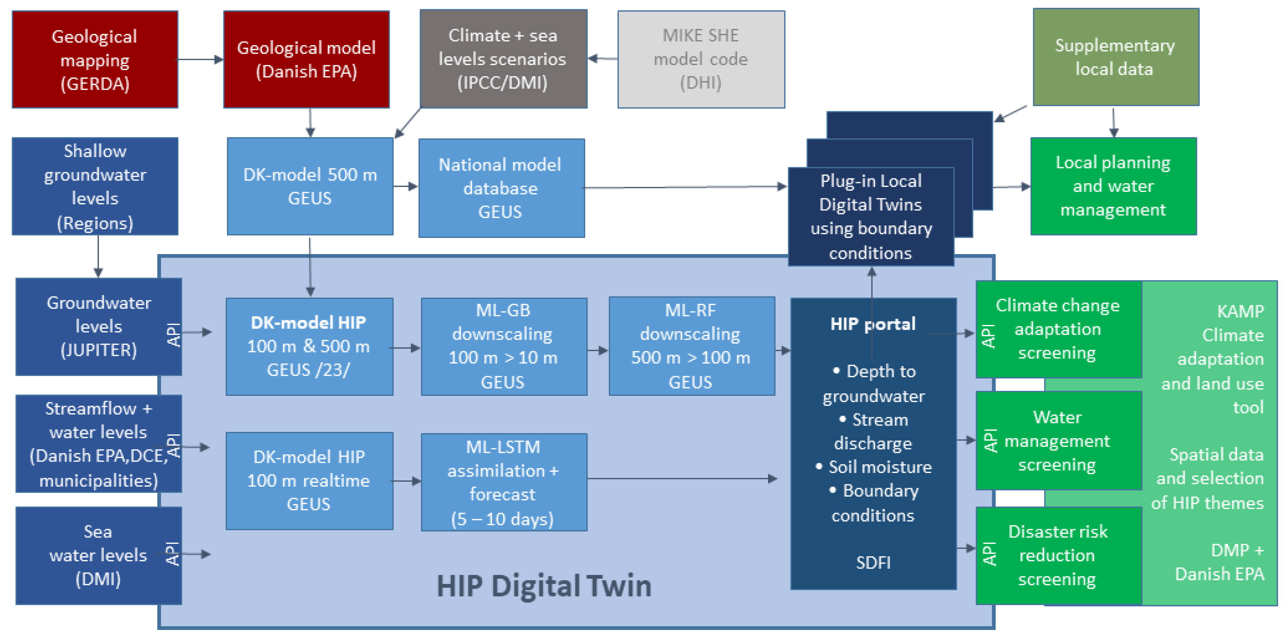
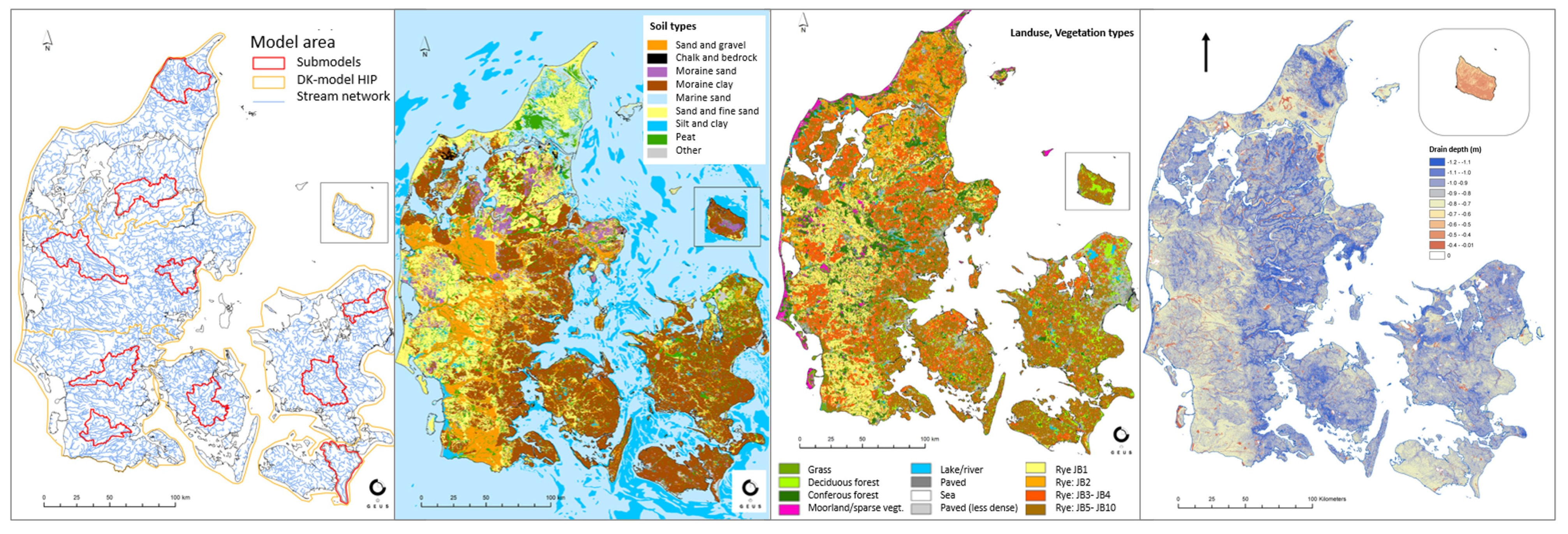
2.2. Danish Case Study—HIP DT for Dealing with High Shallow Groundwater Levels and Water Security

In Denmark, climate change impacts hydrology and groundwater, in combination with increasing sea level rise and storm surges [21], causing new complex challenges with high shallow groundwater [22]. Sewer sealing, land subsidence, and changed groundwater abstraction anthropogenic drivers engrave the problem with high groundwater in some urban and peri-urban areas, but at the same time, drought frequency is projected to increase [23,24]. The consequences especially challenge water security, which is critical in Denmark with a 100% groundwater-based drinking water supply. Consequences of increasing shallow groundwater level [25] can be mobilized pollutants, increased leaching of nutrients, water in cellars, damages to buildings and infrastructure, and consequences for human or environmental health (Figure 1).
The main motivation behind the development of the DK-model HIP was that end users, who plan for and implement adaptation measures, needed a more detailed national dataset for shallow groundwater levels, soil moisture, and streamflow, with easy access to results and boundary conditions from the national model for screening, planning, and local submodels. The previous 500 m national DK-model based on the MIKE SHE/MIKE HYDRO model code did not provide sufficient spatial resolution and accuracy for the shallow groundwater. Finally, an enhancement of the deliverables with more detailed monthly, seasonal, and extreme event results of climate change impacts for the future climate was demanded by end users [26,27].
As a result of these challenges, a hydrological information and prediction system (HIP portal) containing, among other things, a new version of the national DK-model simulations in 100 m resolution (DK-model HIP) was developed. The DK-model HIP was designed in a fast-track project (2016–2017) [28] and developed as part of an initiative for terrain, climate, and water under the Joint Governmental Digitalization Strategy 2016–2020 [26].
It was evaluated that data on climate and water are a key administrative foundation for many sectors and authorities. Consistent provision of up-to-date data on terrain, climate, and water across sectors contributes to more effective administration, supports climate adaptations and emergency services in connection with extreme weather events, and promotes the development of new products and technologies. The users are municipalities, water companies, consultancies, regional and state authorities, farmers, landowners, and citizens.
The Danish government, therefore, decided to further develop the DK-model HIP into a real-time model with daily updating to be developed and implemented into the HIP portal (https://hipdata.dk/ “URL(accessed on 1 December 2022)”) in the years 2022 to 2025 (see Figure 2). The development was strongly user-driven. Many different stakeholders from public authorities at local, regional, and national levels, water suppliers, and private companies participated in project groups and workshops, where they contributed local knowledge and user stories expressing their need for data, and they contributed to discussions about the success criteria for the project with a focus on model simulations of the depth to the shallow groundwater and streamflow discharge. The Steering Group comprised members from the Ministry of Climate, Energy and Utilities, the Ministry of Environment, Danish Regions, and the Local Government of Denmark. The new DK-model HIP in 100 m and 500 m (Figure 2) developed in 2019–2021 was based on the DK-model 500 m based on geophysical mapping and a geological model by the Danish EPA [25] used for river basin management plans and groundwater body status assessment [28,29,30,31].
The physical-based DK-model HIP simulates the entire terrestrial hydrological cycle in an integrated manner at a national scale for Denmark. The model is a numerical gridded model based on the MIKE SHE software and is used to simulate coupled 3D subsurface flow, 2D overland flow, rootzone and evapotranspiration processes, and 1D kinematic routing of streamflow. The DK-model is run as a transient model with daily climate forcing and a maximum time step of 24 h. The model is calibrated against a large dataset of river stream flow (305 stations) and groundwater level records (29,000 wells). For further details on model construction and calibration, please refer to [26,32,33].
As part of HIP portal, the physical-based groundwater–surface water model was supplemented with machine learning (ML) algorithms, combining the results from the DK-model HIP in 100 m and 500 m and downscaling them with ML algorithms to model the most likely depth to the uppermost groundwater table in 10 m resolution (ML-GB based on gradient boosting approach) for winter and summer months for a 30-year historical period [7]. Moreover, a combination of the DK-model HIP and ML was applied to downscale climate change impacts on groundwater levels (ML-RF) from 500 m to 100 m resolution [8]. In both cases, the advantages of hybrid modeling [34,35], i.e., the combination of data-driven and physical-based models, providing fast and high-resolution computations with the robustness of process understanding, were used. Throughout the construction of the DK-model, the model code MIKE SHE-MIKE Hydro from DHI was the applied software for the modeling.
All model results from the 500 m and 100 m models have been delivered (5 TB of data) to the HIP portal to be freely accessible for climate change adaptation planning (CCA), water management, and disaster risk reduction (DRR). In addition to model results for various seasons, months, and daily time series, various hydrological observations are displayed on the HIP portal. As part of the HIP portal project, data from five Danish regions for groundwater levels have been transferred to the JUPITER database, and groundwater levels from JUPITER are displayed on HIP, updated in real time.
Observations and estimates of daily discharge and water level data and extreme value estimates have been delivered by the Danish EPA and DCE. Discharge data are updated every year. Climate data and sea level scenarios are available from DMI’s database (Klimaatlas). GEUS used bias-corrected and downscaled results from 22 regional climate models based on distribution-based scaling [36].

2.2.1. Use of Data and Observations as Part of DK-Model HIP Setup—Calibration and Performance Assessment

For the calibration of the model (see details in the HIP documentation report), a total of 667,568 groundwater level observations were used, of which 40,103 intakes (27%) are observing shallow groundwater, as well as time series of discharge from about 300 stations. Additionally, water levels from 20,470 small lakes were used as a proxy of the uppermost groundwater table. The model is parameterized with nationwide parameter sets to enhance spatial consistency. Initial, full calibration was conducted for the 500 m version, with a subsequent transfer of parameters and partial recalibration of the 100 m version based on ten 100 m submodels, each of a size of 500–1000 km2 (see Figure 3).
The results of the 100 m DK-model HIP for the simulated depth to the groundwater table showed a mean absolute error (MAE) of 2.5 m for shallow groundwater within 10 m below the terrain, with the best 90% of observations having an MAE of only 1.5 m. The ML product of the shallow groundwater level at 10 m resolution resulted in an MAE of 1.2 m. It was evaluated that the 100 m model delivered the user-demanded accuracy criteria for more than 75% of the gauging stations concerning simulated runoff for most of the established criteria. The accuracy criteria for streamflow were evaluated by calculating Kling–Gupta efficiency (KGE), water balance error (WBE) for all seasons and summer seasons separately, and extreme stream runoff errors for the first percentile flow (Q01) and 2- to 20-year runoff events (T2–T20). The performance generally honors the criteria at a screening level. For extreme stream runoff, the accuracy did not fully meet the criteria since only 66% of the gauging stations met the criteria for extreme runoff. Moreover, an ML algorithm was utilized for estimating winter and summer maps of depth to the uppermost groundwater level at 10 m resolution (see Figure 4 [7]). This model was a further development of an approach originally developed as part of an EU LIFE-supported climate change adaptation (C2C CC) project, where the 100 m results of the DK-model HIP were utilized in combination with several high-resolution covariates and groundwater-level observations as training dataset.

2.2.2. Climate Change Impact Analysis

For the climate change impact analysis, the 500 m model was used to run impact simulations based on a comprehensive ensemble of 22 regional climate models. Based on these projected impacts, 60 statistics of groundwater level response to climate change (monthly, seasonal, yearly, for mean, Q01, and Q99 groundwater levels as well as extreme values for T = 2- to 100-year return periods) were downscaled to 100 m by use of an ML model [8]—see Figure 5.

2.2.3. Hydrological Information and Prediction System (the HIP Portal)

The HIP portal is an open geodata tool that visualizes and provides access to large, free-of-charge national datasets about hydrological conditions and how they are expected to change with a warmer and wetter climate in the future. Data on depth to the groundwater table (phreatic depth), soil moisture, and discharge are available (daily simulations for 1990–2019). Furthermore, it is possible to download a wide range of boundary conditions (groundwater infiltration, recharge to aquifers, etc.).
Downstream services (Figure 2) can access data from the HIP portal through an API. This is used, for example, by the KAMP portal, which is a screening tool that compares selected national data, calculations, and projections and is aimed, in particular, at supporting planning and environmental tasks in local governments. KAMP shows areas where possible climate change impacts may require attention. KAMP can also be used to determine how many buildings and kilometers of road potentially can be affected by flooding, and it can estimate the value of the buildings and constructions at risk for damages. The tool also contains an option that allows downloading of QGIS files, allowing further work on the same dataset and map sections in the user’s system. KAMP was developed in collaboration between the Danish Natural Environment Portal and the Danish EPA in consultation with the national association of municipalities, KL, the Danish Business Authority, Central Region Denmark, and several selected municipalities. KAMP is available at https://en.klimatilpasning.dk/ (“URL(accessed on 1 December 2022)”).

2.3. Current/Future Developments

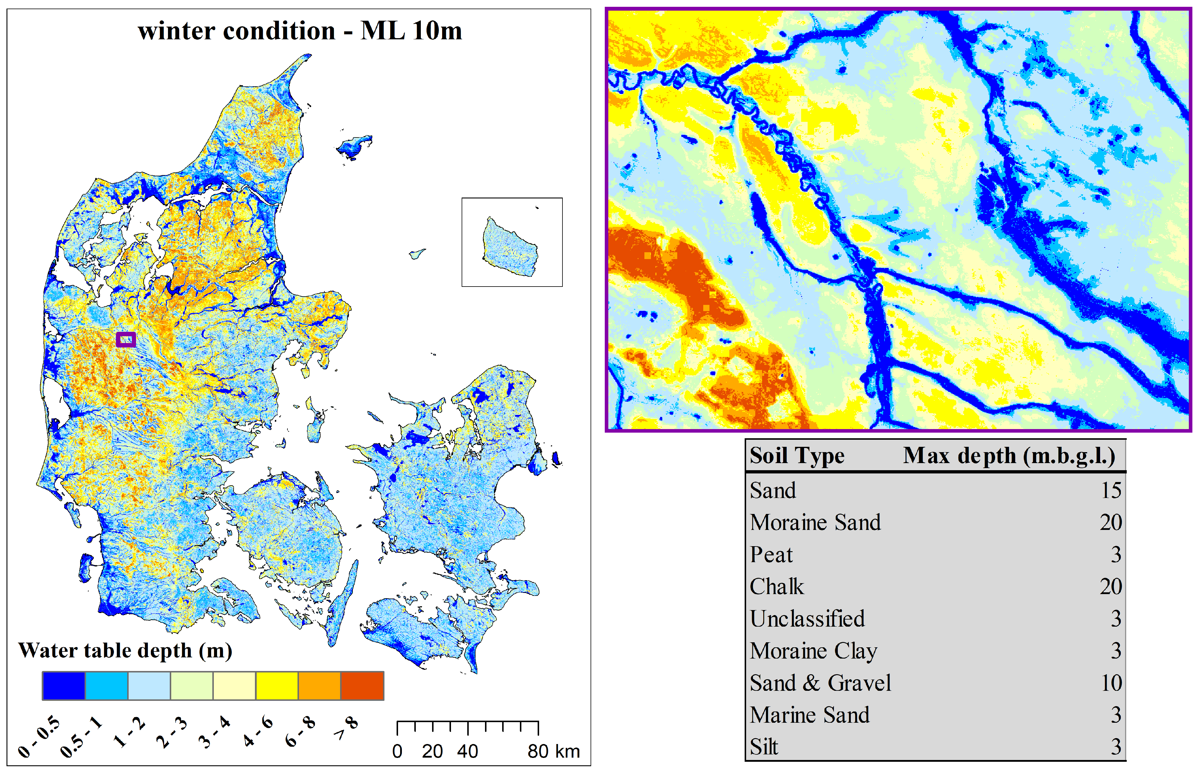
2.3.1. DK-Model HIP 100 m Real-Time Model

For the moment, a beta version of the real-time model is being tested (DK-model HIP 100 m real-time). Within the near future, all of Denmark will be run operationally with daily updates. A database API will be developed and indices for soil moisture, depth to shallow groundwater, deep groundwater, and streamflow will be added, and data transfer and file formats developed to transfer data between the Danish Meteorological Institute (DMI), Geological Survey of Denmark and Greenland (GEUS) and Agency for Data Supply and Infrastructure (SDFI). SDFI will take care of making the real-time data publicly available on the HIP portal, and facilitating the stakeholder engagement process as part of the design of the portal. Figure 6 shows the monthly time series of wetness and drought anomalies for soil moisture, shallow and deep groundwater level, and streamflow for 2010–2019. Figure 7 shows the spatial distribution of the indices for Denmark for the summer of 2018. These drought indices are shown as an example of new relevant output from DK-model, benefiting users once available in real time.

2.3.2. Plug-in Digital Twins and Boundary Conditions for Local Submodels

In various applications, researchers have used dynamic boundary conditions from the DK-model HIP to set up different submodels of local river basins to analyze, e.g., storm surge, backwater effects on groundwater and flooding, or effects of river restoration, partly with hydrodynamic simulations of the stream system. One example is the Ribe River basin, exposed to storm surges and affected by a sluice at the outlet to the Wadden Sea, where different hydrodynamic and flooding process descriptions were compared for the submodels and investigated, to provide a high-fidelity model for flooding issues. The project obtained detailed knowledge on the past, present, and future processes by developing site-specific sea level predictions by obtaining detailed vertical land motion predictions, and assessing the implications on water from land [21].

3. Results

In this section, we first reflect upon the HIP DT in terms of the ‘digital twin factor’ (Section 3.1), with the five relational characteristics [20]; then, we discuss the vulnerability assessment and climate change impacts for different sectors (Section 3.2); finally, we describe the user categories of HIP portal and DT.

3.1. Evaluation of the ‘Digital Twin Factor’ of the HIP DT

The real-time aspect will be implemented as part of the DK-model HIP 100 m in 2022–2025, and in this sense, it will become a digital twin for the prediction and monitoring of the physical entity with daily data and monthly and seasonal wetness and drought indices (see Figure 6) [37]. Early warning (5–10-day forecasts) is going to be supplemented as well in the project period. The plans for enhancing the real-time model also include some sort of data assimilation or model correction, allowing the (near) real-time integration of observations into the model. Details still have to be clarified, e.g., which data assimilation approach to use, as well as the type of data to be assimilated. In addition, various ideas surrounding the hybrid modeling of specific hydrologic variables of interest (such as streamflow or groundwater heads) will be tested. Again, this hopefully harvests the benefits of combined hybrid modeling with physical-based and data-driven models, allowing for accurate and fast predictions without a tradeoff in the robustness of the predictions.
This relation will therefore be established between the technical artifact (DK-model HIP) and the physical entity (groundwater and freshwater cycle of Denmark), with daily updating in (near) real-time. This will be useful for many operational tasks, such as steering the freshwater cycle, pumps, sluices, nature-based solutions, etc., with the DK-model HIP mirroring the wet or dry anomalies and providing real-time awareness about areas with possible flooding or drought risks here and now, or in the coming 5–10 days (as a ‘model of everywhere’ in Denmark). It will be able to identify vulnerable areas and possible exposed areas and infrastructures. The synchronization will be with daily values and dynamic updating, which will be sufficient for groundwater and river flooding in most areas, as well as water security management and flooding and drought risk management.
Regarding high-fidelity, the DK-model HIP delivers an accuracy relevant for screening purposes, and as a PB-GW in 100 m grids, because it is reliable and robust in most areas at such a level [26]. The DK-model HIP has digital twin relational quality at such a level, but in cases where other goals, such as urban rainwater drainage systems, saltwater intrusion, or wetlands, should be handled by the digital twin, this could either require further incorporation of such infrastructures in the national model [38], or development of a plug-in digital twin based on a submodel with boundary conditions from DK-model HIP available in the HIP data portal. Examples of using model structure and boundary conditions from the DK-model HIP were documented based on submodels created during the SeaLevelRise project (https://www.geocenter.dk/projekter/2020-2/sea-level-rise-and-coastal-flooding-in-denmark-past-future-and-policy/ “URL(accessed on 1 December 2022)”) for the Danish catchments of Ribe catchment, Djursland, and Frederiksberg/Copenhagen. The DK-model HIP supplied information on groundwater heads for the whole submodel catchment boundary as well as formed the basis for the following update of the river system with hydrodynamics added on. The river system from the sea to Ribe town was updated to simulate a hydrodynamic river stage with responsiveness to tidal effects, sea level rise, and river flooding (overbank spilling) under current and future climate. Boundary conditions from future climate scenarios available through the HIP portal was utilized in the local submodel. Similarly, the DK-model HIP provided boundary conditions and initial setups for an urban catchment covering the greater Copenhagen area and Frederiksberg for simulation of sea level rise issues, e.g., groundwater flooding, drainage of rainwater through sewage systems, saltwater intrusion, and water security.
Predictive quality: The DK-model HIP has predictive quality in terms of simulating the historical period (1990–2019) and future climate change impacts for near (2041–2070) and far future (2071–2100) for RCP4.5 and RCP8.5 intermediate- and high-emission scenarios [23]. The DK-model HIP is qualified as a digital twin in this sense, due to future water cycle changes, increasing irrigation amounts, scenario analysis [39], etc., being simulated in a physically based model. It will also be in real time [37] and prognostic with continuous forecasting by 2025 (5–10 days) at the latest. Improved ML models (peatland DK-model HIP peatland plug-in) is currently under development, in order to provide an improved tool to mitigate climate change, and due to the increased political awareness in peatland hydrology a more accurate model is required. The depth of the water table is the driving variable in carbon emissions from peatland soils, and knowledge of hydrological variability in peatlands is expected to guide the restoration of drained and intensively farmed peatlands. In this context, a knowledge-guided ML DK-model HIP approach [8] is used to model water table depth at high-spatial-resolution modeling. The modeling is expanded by additional water table observations in peatlands, and additional covariates that are sensitive to the shallow water table variability in peatlands, i.e., land surface temperature or crop types, are added to the model. The regional water table is added from the DK-model HIP at 100 m resolution to inform the peatland plug-in ML model.
Prescriptive quality: The HIP model is a physically based model; hence, we assume that it somewhat reasonably represents the different fluxes (many of which we cannot directly quantify, but still are interested in, such as drainage flow, etc.). It also runs with demand-driven irrigation, and actual extraction amounts. Prescriptive quality, in the sense of the model being as simple and consistent as a reference model, is strived for. Prescriptive quality is also a matter of transparency of the model, which we believe is high since observed discharge and groundwater level data and performance results at calibration locations are shown on the HIP portal. Mean errors between observed and simulated groundwater levels and KGE, Q01, etc., for 300 river stations are made transparent for the user on the HIP portal for two validation periods and the calibration period. This means that the digital twin can signal deficiencies in the physical entity. Prescribing how the water cycle during wet and dry conditions should be designed as part of climate change adaptation and mitigation either temporally or permanently, thus, can be facilitated.
Feedback from the digital twin to the physical entity is mainly something that is provided indirectly by informed decision-making. However, such feedback relational quality could be further enhanced with the real-time model, which potentially can be used for control of a wide range of physical things related to nature-based solutions, etc. At the moment, there is no direct steering of autonomous systems based on the DK-model HIP. Water levels in streams are only simulated with a simplified routing method, and the present focus of the model is mainly on describing soil moisture, depth to shallow groundwater level, boundary conditions for deeper groundwater, and streamflow on daily basis. Interaction with infrastructure (sluices, urban area storage systems, etc.), vegetation, and sediment dynamics in streams, storm surges, and saltwater intrusion is not fully incorporated in the national model but can be handled in plug-in digital twins. There is, however, at the moment, also a possible feedforward quality, in terms of building the local plug-in submodel on top of the model structure from the national DK-model HIP. The development of the DK-model HIP and ML algorithms is scientifically peer-reviewed. It is possible to download boundary conditions and results for each of the 22 global–regional climate models from HIP portal to be used in local plug-in DT. Selected model results are also available on the KAMP climate change adaptation and land use tool (https://en.klimatilpasning.dk/tools/kamp/ “URL(accessed on 1 December 2022)”), relevant for exploring the vertical frontier between land use and groundwater.

3.2. How Do Different Sectors in Denmark Evaluate Climate Change Flooding and Drought Hazard, Exposure, Vulnerability, and Risks Related to Water Security?

This section is a brief summary of water-related issues most relevant in the Danish case. In Denmark, relevant climate change impacts on different aspects of the hydrological cycle are foreseen. In the long term, the future climate will develop according to the future emissions of greenhouse gases. It is evaluated that the changing climate with rising temperatures, changing precipitation patterns, increase in extreme weather events, and rising sea levels will have a broad impact on ecosystems and society in general [40].
Denmark has historically been viewed as a robust country in relation to climate-related incidents, but in recent years we have seen more extreme events with flooding and drought (Copenhagen cloudburst July 2011; winter flooding in Gudenåen, Bygholm stream, and Ribe stream in February 2020, and the agricultural drought in 2018), which, in combination with very intensive land use, urbanization, pollution, increased water demands for various sectors, and a limited groundwater resource, can threaten the long-term sustainable groundwater abstraction [23]. Furthermore, the shallow groundwater level is rising due to increased winter precipitation. Predictions point to an average nationwide rise in shallow groundwater levels in winter of 20–30 cm (RCP8.5, 2071–2100 compared with 1990–2019); however, the patterns of the changes are complex, with large geographical variations ranging from zero to more than 75 cm for some areas. Significant increases to high-streamflow events have been predicted with climate factors of 2 to 5 for a 100-year annual maximum discharge return value for the eastern part of Denmark and 1.25 to 2 for the western part for RCP8.5 2071–2100, compared to maximum annual runoff for 1990–2019. This development, with significant climate factors of maximum discharges in streams far above the similar climate factors for precipitation, has also been seen elsewhere [41,42], and is due to the nonlinear and complex conditions, especially for artificially pipe-system-drained moraine till and/or chalk aquifer systems, when exposed to coupled winter rain events.
Due to the increased evapotranspiration in spring and summer in Denmark, soil moisture, streamflow, and groundwater drought in summer and autumn will be more frequent in a future climate, which challenges water security, e.g., drinking water, food, energy water consumption, and water for ecological flow, aquifers, and environmental health [26].
The Danish cities, towns, and infrastructure will also be affected by increased shallow groundwater levels and more frequent groundwater flooding. Increased groundwater levels will also lead to increased flows in sewage systems, as these today often act as additional drainage systems due to leakages. This can result in more frequent flooding of wastewater systems, overflow events, and subsequent flooding of terrain, buildings, and basements, which in turn pose a risk to human health [43].
The groundwater and water supply sector operating wellfields, often in peri-urban areas, expect more groundwater recharge in winter with higher recharge to groundwater aquifers. However, seasonal variations and increased groundwater recharge in the upper strata could give more local shallow groundwater flooding problems. A need for alternative drainage systems may arise, but this can eventually also lead to less water in deep groundwater aquifers. Long periods of drought (spring and summer) may bring water supply under pressure.
The agriculture sector foresees a risk of soil compaction by heavy machinery, a concern that will increase with increasing soil moisture during the winter period. Soil compaction can lead to poorer drainage, increased nitrous oxide emissions, inhibited root and plant development, erosion, and difficulties establishing crops. Furthermore, due to water clogging, the increased winter precipitation could have negative effects on production of winter crops. More frequent and/or longer periods of drought increase the irrigation demand. An increase in irrigation, which is mainly extracted from groundwater wells, may have a negative effect on summer flows in water courses. The forest sector is concerned about drought stress which could negatively affect forest trees. Trees are vulnerable to climate change, harmful diseases, and pests. In a warmer climate, there is also a risk of more forest fires. Fisheries are concerned about rising temperatures which can have huge impacts on the conditions and composition of fish stocks. Fish are generally adapted to a certain temperature interval. Fish stock composition in Danish waters is expected to change, and rising temperatures may cause oxygen depletion, due to increased nutrient loading.
The energy sector evaluates that warmer summers will also mean a higher need for energy for cooling. Power-to-x [44] may generate new water demands for energy production, and there is also a possibility for more biomass production (to be incorporated into heating and electricity supply). Tourism sector: Denmark is one of the Northern European countries with the best conditions to meet future tourism demand, but this will require additional water, energy, and wastewater services. More investments have to be made in facilities to manage more excessive precipitation and more severe storms.
Aquatic environment: More precipitation will result in increased hydraulic impacts on watercourses. Altered rainfall patterns are also expected to cause longer periods of drought, which may dry out watercourses and have an impact on animal and plant life. Water climate can change species composition and cause more invasive species. The nature and landscape sector is focused on how higher temperatures will provide longer growing seasons, and increases in CO2 will enhance biomass production. More frequent and more intense rainfall will lead to more flooding in low-lying areas. Health sector: Heatwaves can lead to dehydration and heat stroke, which can be life-threatening, since people in Denmark are less used to coping with high temperatures (elderly and young children, people with dementia, etc.). Very allergenic pollen species, such as ragweed, have already found habitat in Denmark. Flooding of built-up areas has been documented to increase the risk of infections in connection with, e.g., work to clear up basements flooded by polluted sewage water (transmission of Weil’s disease/leptospirosis from rats). Outbreaks of tick-borne diseases such as encephalitis (TBE) and Lyme disease will be increased, and, in the long term, also mosquito-borne diseases that are restricted to tropical or subtropical areas today (West Nile virus and Usutu virus). Warmer summers and more precipitation enhance the risk of dampness and mold (asthma attacks and respiratory infections, increased amount of house dust mites) [45].
Emergency preparedness and fire and rescue services highlight that incidents involving flooding require several types of responses from Danish fire and rescue services (during flooding, identification of vulnerable buildings and infrastructures, preventing or mitigating flooding using flood containment means, and pumping water away from low-lying areas). Protection of health and the environment when floodwater becomes contaminated with sewage water or chemicals from industrial areas is a priority. Flooding incidents may cause serious transport accidents. Longer-lasting drought may contribute to the risk of forest wildfire. Increased assistance may also be needed during heatwaves.
The insurance sector evaluates that when weather and climate change impacts are less predictable, insurance companies are less able to predict damage and address risks. Danish insurance companies are typically reinsured by large international reinsurance companies. Climate change will entail a risk of higher premiums, lower coverage, or special terms for taking out insurance. Transition risks arise in the progression towards a greener economy and derive from extensive political, legal, and technological changes, as well as preferential/market change, such as carbon taxes or changes in consumption patterns.
Spatial planning sees climate change as a challenge for both new and existing designation of land. The municipal councils are responsible for spatial planning in Denmark. Spatial planning is an effective instrument of control that can contribute to reducing or eliminating the negative effects, as well as exploiting the positive effects of climate change in a number of sectors and industries. In 2018, new rules of planning were introduced. Their goal is to prevent flooding and erosion in new urban areas. Besides mapping areas in danger of flooding and erosion, it is now compulsory to introduce mitigation or remedial measures if the planned area is assessed to be exposed to flooding and erosion.

3.3. Who Are the Users of the Hydrological Services in Denmark (HIP Portal & DT)?

Municipal and climate adaptation planners will use (and already are using) data on the entire hydrological cycle to better assess opportunities for storing excess water, which often happens in close cooperation with water utilities. There is a need for calculated extreme events for depth to groundwater table and streamflow discharge, in addition to precipitation. Water utilities also express this need for good access to data about the entire hydrological cycle in order to avoid wrong investments and choose the most appropriate means of action, as well as use boundary conditions to develop their own local models, e.g., for watercourses. Municipal planners will typically use model calculations of the depth to shallow groundwater to avoid inappropriate urban planning and improve the database for case processing, for example, to assess where it is possible to build, or whether there is a need for drainage or terrain raising in relation to new build construction. The new high-resolution shallow groundwater depth maps in a 10–100 m grid will be used as a screening basis to identify areas in the local plan where prevention measures must be specified, demands can be made for seepage of surface water, or solutions for local drainage of rainwater (SUDS) can be developed [43,46]. Information about inundation along watercourses will also be used to make agreements with landowners about compensation schemes, and this will be able to reduce case-processing time. Municipal planners also expect that consultant hours can be saved on some tasks, and that it will be possible to set up local models with a significantly smaller grid size at a cheaper price if boundary conditions from HIP are used. User stories from consulting engineers also express the expectation that modeling tasks will be delivered with lower costs due to the better access to data and boundary conditions. The Protection Agency or an upstream municipality will use model calculations and data from HIP to assess the need for regulation, weed cutting, and retention of water to delay downstream water flow, as well as the preparation of long-term watercourse regulations using model-calculated future scenarios for water flow, e.g., using drought and flood scenarios for the future.
The wastewater officer will use all ground-level hydrological data, but especially stream data, to assess the consequences of discharge permits. Groundwater workers will use near-surface groundwater maps to assess possible consequences of setting up and decommissioning extraction wells, as well as consequences for nature and the environment. The watercourse employee will use both measurements and model calculations of water flow and water level, as well as model-calculated effects of climate change, preferably converted to water level (water level calculations are not supplied with the HIP project, but there is an option to download model-calculated water flow and model uncertainties, which can be converted to water level). The high density of model calculation points in HIP (approximately every 0.5 km) (compared to 300 to 600 measuring stations in streams) can be used as boundary conditions together with available local measurements.
Water supply and utility employees express a great need for data and model calculations of shallow groundwater to plan the installation of basins, pumps, buildings, etc., as well as to be able to assess the effects of closing a well or sealing a sewer, which could cause groundwater flooding. It is expected that a more targeted effort can be made against infiltrating groundwater in sewer systems (sewer renovation and renovation prioritization), which will also provide a better function of treatment plants and could reduce the substance load in Danish water bodies. The design of the drainage system and other construction projects are generally expected to be optimized technically, economically, and functionally. It will be avoided that plants are destroyed, and operating costs will be reduced. It is expected that better sewerage investments will provide more robust (fewer floods), attractive, and safe cities. There is a need for screening maps for shallow groundwater levels in the present and future, as well as historical data and model calculations for streamflow and water levels in streams and the sea for the preparation of flood maps for the municipality. The purpose is generally to obtain an overview of potential challenges related to project planning (including urban planning) and choose the most appropriate means of meeting these challenges. Data and model calculations for streams will also be used to assess the capacity and robustness of streams in relation to discharges and storage of water near streams (instead of the establishment of basins) while at the same time avoiding backflow from streams to the sewage systems. Seepage basins will be established, taking into account recipient impact (nature and environment). Outfalls will be planned to be future-proofed, and pipes and basins will be designed in appropriate sizes for efficient water diversion and storage, also for the future. The supply worker wants access to both dynamic and statistical calculations for water flow, and needs to know the maximum level of the water table in 10, 20, 50, and 100 years, including the effect of coupled events (ocean–stream), as well as the uncertainty of model calculations.
The water supply worker sees it as a great advantage that easy and unified access to stream data from different data owners is created in HIP. There is also a strong desire for joint access to water level data for both streams and the sea (coastal zones) in HIP. There is widespread interest among supply workers in the use of boundary conditions for the development of their own local models. This reflects that the utility worker has a great need to use data and model calculations about the entire hydrological cycle. The use of boundary conditions for the development of a local model can, for example, be used to control structures such as automatic dampers, sluice gates, and pumps in streams, lakes, etc., which will optimize the climate control system’s function and reduce operating costs. Model calculations concerning the entire water cycle, including floods, will also allow for the planning of larger climate adaptation projects in synergy with projects regarding park renovation, nature restoration, etc. Much more cost-effective solutions are expected here, and there will only be a need to include smaller areas for pools within urban areas. There will also be better opportunities for identifying opportunities for retaining and storing water in agricultural areas to avoid flooding of towns located downstream, as well as providing a better basis for dialogue with farmers.
Regional employees within soil pollution, resource utilization, climate, and water: The regional employee within soil pollution wants maps of the depth to groundwater close to the ground over 50 years, which can be used for climate-robust risk assessment of soil pollution. Today, the risk of spreading soil pollution due to climate change is unknown. Therefore, contaminations that may pose a risk in the future, and which have therefore not been prioritized for action, are overlooked. There is interest in the groundwater table being scaled down from 100 m to 10 m grid, as well as calculated effects of climate change. Scaled-down maps and model calculations for the future of groundwater close to the ground will be usable for prioritizing efforts, as that the spread risks for the most problematic pollutants will be able to be identified and averted first.
The regional resource utilization officer will use maps for shallow groundwater to grant correct permits for resource extraction and groundwater lowering. Here, it is important to know whether digging will be executed below the water table. The regional employee within climate and water experiences a great need for a common basis and models across municipalities, utilities, and advisers, and expects that the rationalization gain for nationwide model calculations for the water cycle will be large in terms of avoiding wrong investments in the long run. There is a lack of integrated knowledge about catchment water, i.e., model calculations that take into account the water cycle and deliver integrated calculations for the entire catchment, in order to contribute to the facilitation of water management and planning across municipal boundaries. This is expected to reduce malinvestments in infrastructure, urban development, and agricultural operations.
Employees in the state will especially use model calculations for shallow groundwater together with other data for infrastructure planning and securing railways and roads against flooding, as well as for the preparation of flood maps/emergency maps. It is expected that the use of model calculations will lead to fewer and/or smaller pools than are used today, that there will be fewer errors and accidents, that disputes with neighbors and stakeholders will be easier to resolve, and that there will be better opportunities for prioritization and reduced costs for expropriation, construction, operation, and maintenance, and, thus, generally a better economy. Model-calculated effects of climate change will be used in the transport sector to identify intervention areas that may be affected by flooding in the future, either from rising groundwater or rainwater. Better access to ground-level bearing data and water flow data will also be used for more efficient groundwater mapping throughout the country, and more water level data in a common database will be used to make better calculations of water flow that will be used by municipalities and advisors.
Agriculture will benefit from the model-calculated depth to groundwater close to the ground in the short and long term, so that it is possible to distribute effort and prioritization of the fields differently, so that land that is not thought to be suitable for cultivation can, for example, be used for storing water. It is important that the uncertainty is known for model calculations. It is expected that model calculations can contribute to the farmer being able to assess the cause of problems with water, which is difficult for him to assess today. Depending on the crop, there are studies that show that a permanent groundwater table 0.4 to 0.5 m below ground gives a yield loss of 50% compared to a groundwater table at 1 to 1.5 m below ground.
IT developers would like to have easy access to download national data in standard GIS formats, including extreme value statistics, so that they can be used to develop better tools and develop methods for new screening products that can be exported to countries where the same methods and data are not yet available. Digital data and model calculations will be brought into new contexts, so that data come into play where and when decisions have to be made. The effect is better and more realistic planning.
Engineering consultants want access to hydrological data and model calculations in 100 m grid, with the possibility of downscaling to 10 m grid. The advisor sees it as an advantage that data are delivered in a common portal for hydrological data. This ensures a common basis, which is based on quality-assured data and methods that can be used politically, in municipal planning, and as a starting point for private advisers’ further development of solutions. Consultants will specifically use model calculations of near-terrain groundwater for risk assessment of construction and infrastructure planning, which will lead to more robust buildings and lower costs for new constructions. It is estimated that the uncertainty of risk assessments using model calculations from HIP will be smaller than in current tools, and it is estimated that more qualified analyses could be carried out than today. The nationwide model calculations will be able to be used for screening and planning of project location, where further investigations must be carried out.
Advisors will also use streamflow time series and will greatly benefit from better access to stream geometry data (cross-sectional profiles) in standard formats. It is estimated that better access to stream geometry data could lead to cheaper advice when stream models are to be used for impact analyses and decisions are made about the most effective climate adaptation measures. Several advisers express that they will use boundary conditions from HIP, which enables faster and cheaper development of retail models. It is also considered an advantage for the adviser that a common frame of reference is used across actors and stakeholders.

4. Discussion

4.1. The Integration of Observations and Model Results in HIP DT Visualization

Planning and climate change adaptation tools/portals such as the HIP DT are unique since they build upon an integrated groundwater–surface water dynamical model which hereby provides a system model that is absolutely necessary when evaluating climate change impacts for shallow and deep groundwater, interactions with surface water, and changes in precipitation, temperature, and evapotranspiration. One of the key strengths of the national HIP DT is the possibility to compare time series of shallow and deep groundwater levels from the model with observations available in the JUPITER national database. The transparency of model performance is supported by the visualization of daily time series from model and observations, with calculated statistics making it easy to compare statistics on an annual basis, and for wet and dry extreme values. Shallow groundwater is difficult to observe in boreholes (screens) in some cases, e.g., if there is only a temporary high groundwater level during the wettest winter months, or if during cloudbursts, saturated zones are formed in areas with barriers in infiltration capacity between the root zone and the saturated zone. Observations of groundwater level can never be complete, and there is a clear lack of long time series for shallow groundwater for the uppermost layers of the ground (<10 m below surface). The HIP DT visualizes daily variations in depth to shallow groundwater (phreatic depth), and the results reveal that there is a high degree of transient variation.
Making it possible to make such comparisons, backed up with performance statistics for the calibration period (2000–2010) and two different validation periods (1990–1999 and 2011–2019), the user receives a high-resolution map in 100 × 100 m which is much more useful than previous 500 × 500 m simulations. Not only are shallow groundwater levels available with daily values for the 30-year period, but, in addition, various percentiles and return values are available for each 100 m grid and each of more than 50,000 streamflow points. In some cases, the model will be wrong or uncertain; in other cases, observations are biased or wrong. By integrating both datasets and displaying and visualizing data on the HIP portal, the basic idea of the digital twin gains momentum, and users, area for area, can evaluate where the model has a good enough performance at a screening level, or where observations indicate that there can be something missing in the model structure, the process description, or the input data, and, eventually, the boundary conditions [23].
Another major feature and strength of HIP DT is the possibility of utilizing the high-resolution 10 m national map, obtained with machine learning. Here, the observed shallow groundwater levels were reused to create a high-resolution map for winter and summer, and observations for 10 soil types were further classified and trained upon as part of machine learning (ML-GB). These maps provide an alternative (twinning) to the modeled maps, where the simulated results from the 100 m model become the second most explanatory variable (or covariate) among a dozen covariates (see [7]).
As part of the HIP project, the best practice guidelines for hydrological modeling and calibration [47,48,49] were updated, with a new set of criteria for the screening model. Hereby, the DK-model HIP in 500 m and 100 m complies with the criteria for a screening model. When developing local models, users can compare their local model performance with the standards prescribed by the DK-model HIP, which makes the model performance more transparent.
Finally, predictive simulations are visualized for depth to shallow groundwater level with statistics for the near and far future, compared to the reference period for 17 RCP8.5 high-emission scenarios (AR5) and 5 RCP4.5 moderate-emission scenarios. Downloads can be made not only of median change across the ensemble of climate models in each emission scenario, but also including standard deviations. Thus, users can incorporate the global and regional climate model uncertainty, a major source of uncertainty when planning for adaptation for shallow groundwater [19]. Again, in order to provide robust predictions in the required resolution (here, 100 m was demanded by the users), results from the 500 m HIP model were downscaled to 100 m [9] by the use of ML-RF. The improved resolution obtained makes the predictions more trustworthy, and the integration of the selected climate model runs for five submodels with future climate change simulations, results from the 500 m model, the results from the 100 m model for the historical period, and other covariates provides an overall more robust projection of hydrological impacts on shallow groundwater levels.
The HIP DT and KAMP are mainly for screening purposes. KAMP focuses on spatial planners in municipalities and a wide set of areal data, and HIP DT provides data, useful for the professional user, consultants, and employees at municipalities, regions, and state agencies. Besides these users, researchers can also dive into the huge dataset on shallow groundwater. Citizens, with some help from more experienced users, can search for valuable information from the HIP DT, KAMP, JUPITER, or other tools available from the national climate change adaptation portal: www.klimatilpasning.dk “URL(accessed on 1 December 2022)”). Nature-based solutions (recommended by the EU commission) only provide a few adaptation measures against high groundwater levels (there are many more NBSs for too-low groundwater levels). In both cases, DTs are valuable, because the users can compare what has been measured with what has been modeled, and this is important, not for claiming that the model is wrong, but for a better understanding of where other factors may provide differences in groundwater level (it can be due to drainage systems not working properly, lowering of groundwater levels by reduced pumping, not well-described issues of the model, e.g., misinterpretation of model structure, etc.). In such cases, the users sometimes conclude that the HIP model or the observations are wrong. In such cases, new and better observations, or better model input data and conceptualization, are required. With tools such as the HIP DT, modeling of everywhere becomes a search for areas with poor model performance, such as areas where the observed depth to the groundwater level does not fit with the simulated depth. In the digital twin era, the task of the user is to evaluate such circumstances and to identify an issue or a problem, which is not sufficiently understood. Since the HIP DT is created on top of the national DK-model, in some cases a new geological model may be required, or new monitoring data (where especially time series of shallow groundwater levels) will be the first action or decision to take in cases with poor model performance.

4.2. Possible Strengthening of the Use of HIP DT with the Development of Real-Time Model with a 5–10-Day Forecast for Disaster Risk Reduction Purposes

When reading the IPCC AR6 WG2 report [2] from a groundwater perspective, various chapters mention groundwater. This is the case for Chapter 4 Water, where groundwater is mentioned more than 200 times in that chapter. However, not a single quote really mentions shallow groundwater and the problem with high groundwater levels. Of other chapters in the IPCC WGII report where groundwater is mentioned, Chapter 9 Africa, Chapter 10 Asia, and Chapter 14 North America, and Chapter 15 Small Islands each have more than 20–50 mentions of groundwater. Finally, Chapter 2 Terrestrial and freshwater ecosystems, Cross-Chapter 4 Mediterranean region, Cross-Chapter 5 Mountains, Chapter 13 Europe, and Chapter 16 Food, fibre and other ecosystem products have between 15–20 mentions of groundwater. Still, the description of the role of groundwater is much stronger in AR6 than in previous reports, and Chapter 4 is especially worth studying, but particularly when the focus is on water security and other cross-sectoral water uses. It is quite remarkable that the chapter on cities does not have groundwater higher up on the list, and that the one on Europe does not unfold the challenges with high groundwater levels in Northern Europe, where the other side of the coin is a lack of water in spring, summer, and autumn [2].
In the context of climate change, [2] makes a strong contribution to the water community. This is because the report places much effort on explaining how risk can arise from the dynamic interactions among climate-related hazards (with reference to WG1 report) and the exposure and vulnerability of affected human and ecological systems. Here, the risk that can be introduced by human responses to climate change is a new aspect considered in the risk concept, and it is here that our HIP real-time model actually becomes an important future development and extension of the HIP DT. Approaches for analyzing and assessing vulnerability have evolved since previous IPCC assessments, and vulnerability is widely understood to differ within communities and across societies, regions, and countries, also changing through time. This is exactly what we see with the HIP DT, where parts of the country will expect increasing groundwater levels, and other parts zero changes, in a future climate. Alternatively, parts of the country will expect doubled to five-doubled 100-year maximum annual discharge events, according to RCP8.5, for 2071–2100 compared to 1990–2019 [26], and even with significant increases in shallow groundwater levels and/or streamflows, in other seasons we can expect a reduction in soil moisture and more severe drought events in the future climate [23]. Then, for water security, everything becomes even more complex, because climate change can also trigger tipping points, increased pollution, etc., whereby the amount of clean drinking water becomes more scarce or even turns into a situation of groundwater drought in a case where a dry winter is followed by a dry summer, which is again followed by a dry winter, etc.
Adaptation plays a key role in reducing exposure and vulnerability to climate change, and the HIP DT is very much focused on bringing all the necessary maps and areal regulations to the table in order to explore possible adaptive planning and nature-based solutions which can reinforce the resilience of infrastructure, combating measures of different kinds, and land use planning, which identifies which land uses are optimal for given hydrological conditions now and in the future. Often, resilience is understood as bouncing back and returning to a previous state after a disturbance, but resilience is also the capacity for transformation, and in many cases, good planning is better than emplacing inflexible engineered adaptation measures such as dikes, pumps, etc. A critical question here is to which degree does the HIP DT build on, or incorporate, local knowledge? The answer is that it does not, but that local knowledge is available in the minds of stakeholders and in the municipalities. In some cases, this local knowledge will tell the users, if they work in a participatory living lab fashion, that the HIP DT is not useful. In such cases, there may not be any other way forward than to develop a local HIP model, and this is possible if GEUS delivers a setup that can be further enhanced with boundary conditions from the HIP DT, and the process can be improved or model structures further detailed. GEUS and others have successfully generated or ‘fed forward’ into local models from the HIP model structure, and set up local models with improved unsaturated zone description, overland flow, and hydrodynamic description in rivers and drains, or improved description of chalk and saturated zone, eventually also in saltwater intrusion.
The IPCC WGII report [2] also highlights maladaptation, which refers to actions that may lead to increased risk of adverse climate-related outcomes, including increased greenhouse gas emissions, shifted vulnerability to climate change, inequitable outcomes, or diminished welfare, now or in the future. Most often, this is an unintended consequence. When we analyze the problems with high groundwater levels, especially in Danish cities, it is clear that in some cases this can be due to maladaptation. In some cases, dams break during extreme events, or pumps stop functioning when they are flooded. In other cases, SUDS and nature-based solutions on the surface result in increased groundwater infiltration and groundwater levels in cities. Yet, in other cases, a solution to one problem results in another problem, either downstream or upstream, or an additional flux, or changed flux, generates a water quality problem. Therefore, it is very important that a systemic approach and nature-based solutions which are more flexible are in the toolbox for climate planners and managers.
In many parts of the world, extreme weather events cause severe floods and droughts. Such events are becoming more and more likely. Therefore, dynamic updating of HIP DT on a daily basis, and with 5–10-day forecasts, can support adaptive planning and use of various assets (utilities) and adaptation measures (nature-based solutions). Too much water and too little water both can deteriorate ecological flows. Changes in streamflow magnitude, timing, and associated extremes are projected to adversely impact freshwater ecosystems in the mid to long term across all assessed scenarios (medium confidence [2]). The same, without a doubt, is true for changes in shallow groundwater levels in relation to terrestrial and aquatic ecosystems, and when incorporating adverse effects of deep groundwater levels and water security.
The HIP (real-time) DT from 2025 can provide a new knowledge base and capacity in real time for water managers at a local, regional, and national level, stakeholders, researchers, utilities, and industry to safeguard sustainable groundwater abstraction from the shallow and deep aquifers of different water quality and for different uses, groundwater drainage, and/or managed aquifer recharge, with adequate quantities in the long term of good quality water for sustaining livelihoods, human wellbeing, ecological flow, and socioeconomic development. This will also better ensure protection against waterborne pollution and water-related disasters, and for preserving ecosystems. We no longer have a climate of peace and political stability, but with help from the real-time version of HIP DT, we can better assure water security.

4.3. HIP DT as a Tool for Screening and Adaptive Planning for More Resilient Infrastructures, Land Uses, and Robust Water Futures

Another important highlight from IPCC 2022 [2] is the recommendation to place more effort into cascading risk. Climate change impacts and risks are becoming increasingly complex and more difficult to manage. Multiple climate hazards will occur simultaneously, and multiple climatic and nonclimatic risks will interact, resulting in compounding overall risks, cascading across sectors and region (high confidence). This is maybe the strongest argument for an HIP DT for shallow groundwater, streamflow, soil moisture, and boundary conditions for deep groundwater. What we can achieve with HIP (real-time) DT will be to describe anomalies in wet and dry conditions, and also, with the integrated DK-model HIP, diagnose various types of wet and dry conditions. The distinction between meteorological drought, soil moisture (agricultural) drought, streamflow drought, groundwater drought, and socioeconomic drought is one known example. This is what HIP DT can provide for us 5–10 days before the event develops into a compound event. Thus, people can move valuable belongings to higher ground, and emergency management can plan logistics and where to bring pumps, temporary dams, etc. This means that the HIP DT in a real-time version can enhance our ‘augmented reality’ or ‘awareness’ about various risks.
For inland flooding, combinations of nonstructural measures, such as early warning systems, and structural measures, such as levees, reduce loss of lives and damage costs. Enhancing natural water retention by managed aquifer recharge, restoring wetlands and streams, and land use planning, such as no-build zones or upstream forest management, can, as further nature-based solutions, reduce flood risk. Nature-based solutions include a broader range of approaches, including those that contribute to adaptation and mitigation, even though the term is a subject of ongoing debate [2] because the term cannot on its own provide a global solution to climate change. As we have seen for the problem with high shallow groundwater levels in cities and elsewhere, a systemic approach is required, but clear roles and responsibilities, national and municipal adaptation strategies, plans and initiatives, monitoring and evaluation of the framework, regulation, and partnerships are equally important.
The HIP DT, therefore, has a very high potential for becoming an important national tool as part of implementing nature-based solutions (NBS) for the sustainable management of water resources in a changing climate. Supported with plug-in DTs in local cases, local knowledge and coproduction with national and local stakeholders of cost-effective ways of implementing NBS at large scales for integrated water management can be supported for demonstration and wider replication. This can also enhance implementation of EU policies, Water Framework Directive, the Floods Directive, EU Climate Adaptation, the EU biodiversity and EU soil strategies for 2030, and the Floods Directive where needed. The new HIP DT can help assure that rural, coastal, and urban areas are developed in a sustainable, balanced, and inclusive manner, thanks to a better understanding of the subsurface and groundwater system as well as deployment of digital, social, and community-led innovations that ultimately will make society more resilient, inclusive, and healthy with flooding- and drought-approved (or aware) green rural, coastal, and urban communities.
Digital twins such as HIP DT and plug-ins also raise new issues to consider. There is a need for new governance models enabling sustainability and resilience to be established and monitored through enhanced and shared use of new knowledge, tools, foresight, and environmental observations, as well as digital, modeling, and forecasting capabilities. The HIP DT is a national-scale hydrological DT. There is some potential for this national model to provide a modeling and monitoring observatory for European and global hydrological DTs, which could enable a better representation of groundwater in such (basically) rainfall-runoff models. Best practices for development of such Earth digital twins [13] is an open question at the moment.

4.4. The Main Preconditions for Introducing a National Hydrological Digital Twin

One potential precondition for introducing a digital twin at the national level is the availability of high-quality data from a variety of sources, including sensors, monitoring systems, and other sources of information. Such data need to be collected, cleaned, standardized, and integrated into the digital twin in order to create an accurate and useful model. Additionally, there may be a need for advanced computing resources and expertise in order to develop and maintain the ability of the digital twin to provide standardized data that enable users to easily combine data with other global, national, or local data and information. This could include real-time remote sensing data about water level thresholds or emergency measures for a specific area to mitigate the risks of floods and water scarcity.
Another precondition for introducing a digital twin at the national level is the development of clear goals and objectives for the project, as well as a plan for how the digital twin will be used and by whom. This should involve working with stakeholders from a variety of sectors, including government, academia, and industry, in order to identify potential applications, opportunities, and benefits of the digital twin.
Overall, introducing a digital twin at the national level is a complex undertaking that requires a significant investment of resources and expertise. However, if executed correctly, it can provide valuable insights and support decision-making in water management, climate change adaptation, and disaster risk reduction. This can strengthen sustainable groundwater management and water security, be helpful as part of codesign of various nature-based solutions, and support other sectors in climate change adaptation, mitigation, disaster risk reduction, and adaptive planning.

Author Contributions

Conceptualization, H.J.H.; methodology, S.S., E.B., H.J.H., R.S., J.K., L.T., M.O. and S.J.K.; software, L.T. and R.S.; validation, H.J.H. and E.B.; formal analysis, H.J.H.; investigation, H.J.H.; resources, E.B. and H.J.H.; data curation, L.T., M.O., R.S. and J.K.; writing—original draft preparation, H.J.H.; writing—review and editing, H.J.H., I.K.S., R.S., J.K., S.J.K., E.B. and S.S.; visualization, R.S., M.O., J.K., E.B. and H.J.H.; supervision, S.S.; project administration, H.J.H.; funding acquisition, E.B. and H.J.H. All authors have read and agreed to the published version of the manuscript.

Funding

Danish Ministry of Climate, Energy and Utilities. Milestone 54: Initiative: “Climate adoption—Better data on water”.

Data Availability Statement

Denmark-wide data produced as part of HIP is freely available from the HIP data portal: https://hip.dataforsyningen.dk/ “URL(accessed on 1 December 2022)”. The DK-model 2019 can bee assessed from the DK-model portal: https://vandmodel.dk/ “URL(accessed on 1 December 2022)”.

Acknowledgments

This paper was developed as part of the HIP real time projects, which is part of the Joint National Digitalisation Strategies 2022–2025 and 2016–2020.

Conflicts of Interest

The authors declare no conflict of interest.

References

  1. EC 2021. EU Strategy on Adaptation to Climate Change. COM/2021/82 Final. Available online: https://eur-lex.europa.eu/legal-content/EN/TXT/?uri=COM:2021:82:FIN (accessed on 1 December 2022).
  2. Pörtner, H.-O.; Roberts, D.; Tignor, M.; Poloczanska, E.; Mintenbeck, K.; Alegría, A.; Craig, M.; Langsdorf, S.; Löschke, S.; Möller, V. (Eds.) IPCC, 2022: Climate Change 2022: Impacts, Adaptation, and Vulnerability. Contribution of Working Group II to the Sixth Assessment Report of the Intergovernmental Panel on Climate Change; Cambridge University Press: Cambridge, UK; New York, NY, USA, 2022. [Google Scholar] [CrossRef]
  3. Grey, D.; Sadoff, C.W. Sink or Swim? Water security for growth and development. Water Policy 2007, 9, 545–571. [Google Scholar] [CrossRef]
  4. Bijl, D.L.; Biemans, H.; Bogaart, P.W.; Dekker, S.; Doelman, J.C.; Stehfest, E.; Van Vuuren, D.P. A Global Analysis of Future Water Deficit Based on Different Allocation Mechanisms. Water Resour. Res. 2018, 54, 5803–5824. [Google Scholar] [CrossRef] [Green Version]
  5. Berrang-Ford, L.; Siders, A.R.; Lesnikowski, A.; Fischer, A.P.; Callaghan, M.W.; Haddaway, N.R.; Mach, K.J.; Araos, M.; Shah, M.A.R.; Wannewitz, M.; et al. A systematic global stocktake of evidence on human adaptation to climate change. Nat. Clim. Chang. 2021, 11, 989–1000. [Google Scholar] [CrossRef]
  6. Koch, J.; Berger, H.; Henriksen, H.J.; Sonnenborg, T.O. Modelling of the shallow water table at high spatial resolution using random forests. Hydrol. Earth Syst. Sci. 2019, 23, 4603–4619. [Google Scholar] [CrossRef] [Green Version]
  7. Koch, J.; Gotfredsen, J.; Schneider, R.; Troldborg, L.; Stisen, S.; Henriksen, H.J. High resolution water table modelling of the shallow groundwater using a knowledge-guided boosting decision tree model. Front. Water 2021, 3, 701726. [Google Scholar] [CrossRef]
  8. Schneider, R.; Koch, J.; Troldborg, L.; Henriksen, H.J.; Stisen, S. Machine-learning-based downscaling of modelled climate change impacts on groundwater table depth. Hydrol. Earth Syst. Sci. 2022, 26, 5859–5877. [Google Scholar] [CrossRef]
  9. Cuthbert, M.O.; Gleeson, T.; Moosdorf, N.; Befus, K.M.; Schneider, A.; Hartmann, J.; Lehner, B. Global patterns and dynamics of climate–groundwater interactions. Nat. Clim Chang. 2019, 9, 137–141. [Google Scholar] [CrossRef]
  10. Anderson, M.P.; Woessner, W.W.; Hunt, R.J. Applied Groundwater Modeling. Simulation of Flow and Advective Transport, 2nd ed.; Academic Press: Cambridge, MA, USA, 2015; ISBN 9780120581030. [Google Scholar]
  11. Scholten, T.; Hartmann, T.; Split, T. The spatial component of integrated water resource management differentiating integration of land and water governance. Int. J. Water Resour. Dev. 2020, 36, 800–817. [Google Scholar] [CrossRef] [Green Version]
  12. Haasnoot, M.; Klooster, S.; val Alphen, J. Designing a monitoring system to detect signals to adapt to uncertain climate change. Glob. Environ. Chang. 2018, 52, 273–285. [Google Scholar] [CrossRef]
  13. Rigon, R.; Formetta, G.; Bancheri, M.; Tubini, N.; D’Amato, C.; David, O.; Massari, C. HESS Opinions: Participatory Digital Earth Twin Hydrology systems (DARTHs) for everyone: A blueprint for hydrologists. Hydrol. Earth Syst. Sci. 2022, 26, 4773–4800. [Google Scholar] [CrossRef]
  14. Abbott, M.B.; Bathurst, J.C.; Cunge, J.A.; O’Connell, P.E.; Rasmussen, J. An introduction to the European hydrological system—Systeme hydrologique europeen, “She”, 2: Structure of a physically-based, distributed modeling system. J. Hydrol. 1986, 87, 61–77. [Google Scholar] [CrossRef]
  15. Maxwell, R.M.; Condon, L.E.; Melchior, P. A Physics-Informed, Machine Learning Emulator of a 2D Surface Water Model: What Temporal Networks and Simulation-Based Inference Can Help Us Learn about Hydrologic Processes. Water 2021, 13, 3633. [Google Scholar] [CrossRef]
  16. Tran, H.; Leonarduzzi, E.; De la Fuente, L.; Hull, R.B.; Bansal, V.; Chennault, C.; Gentine, P.; Melchior, P.; Condon, L.E.; Maxwell, R.M. Development of a Deep Learning Emulator for a Distributed Groundwater–Surface Water Model: ParFlow-ML. Water 2021, 13, 3393. [Google Scholar] [CrossRef]
  17. Koch, J.; Schneider, R. Long short-term memory networks enhance rainfall—runoff modelling at national scale of Denmark. GEUS Bull. 2022, 49, 8292. [Google Scholar] [CrossRef]
  18. Ariesen-Verschuur, N.; Verdouw, C.; Tekinerdogan, B. Digital Twins in greenhouse horticulture: A review. Comput. Electron. Agric. 2022, 199, 107183. [Google Scholar] [CrossRef]
  19. Glaessgen, E.; Stargel, D. The Digital Twin Paradigm for Future NASA and US Air Force vehicles. 2012. Available online: https://ntrs.nasa.gov/api/citations/20120008178/downloads/20120008178.pdf (accessed on 1 December 2022).
  20. Korenhof, P.; Blok, V.; Kloppenburg, S. Steering Representations—Towards a Critical Understanding of Digital Twins. Philos. Technol. 2021, 34, 1751–1773. [Google Scholar] [CrossRef]
  21. Colgan, W.; Henriksen, H.J.; Bennike, O.; Ribeiro, S.; Keiding, M.; Seidenfaden, I.K.; Graversgaard, M.; Busck, A.; Fruergaard, M.; Knudsen, M.H.; et al. Sea-Level Projections for Denmark: Recent Advances. GEUS Bull. 2022. in print. Available online: https://geusbulletin.org/index.php/geusb (accessed on 1 December 2022). [CrossRef]
  22. Refsgaard, J.C.; Sonnenborg, T.O.; Butts, M.B.; Christensen, J.H.; Christensen, S.; Drews, M.; Jensen, K.H.; Jørgensen, F.; Jørgensen, L.F.; Larsen, M.A.D.; et al. Climate change impacts on groundwater hydrology—Where are the main uncertainties and can they be reduced? Hydrol. Sci. J. 2016, 61, 2312–2324. [Google Scholar] [CrossRef] [Green Version]
  23. Chan, S.S.; Seidenfaden, I.K.; Jensen, K.H.; Sonnenborg, T.O. Climate change impacts and uncertainty on spatiotemporal variations of drought indices for an irrigated catchment. J. Hydrol. 2021, 601, 126814. [Google Scholar] [CrossRef]
  24. Karlsson, I.B.; Sonnenborg, T.O.; Seaby, L.P.; Jensen, K.H.; Refsgaard, J.C. Effect of a high-end CO2-emission scenario on hydrology. Clim. Res. 2015, 64, 39–54. [Google Scholar] [CrossRef] [Green Version]
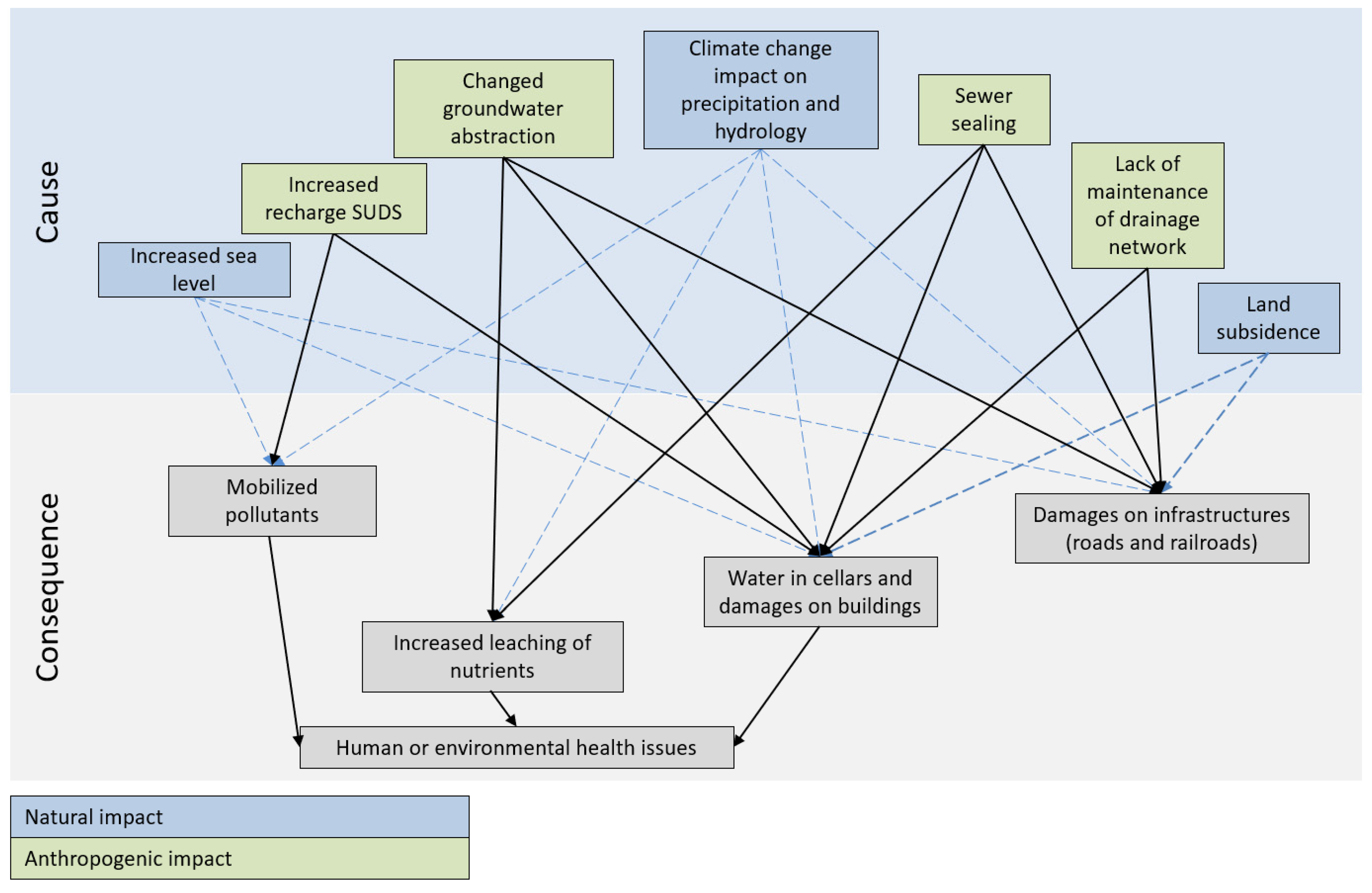
  25. Danish EPA. Report on Fast Track Project on High Groundwater Level in Urban Areas (In Danish: Afrapportering Fra Fast Track Projekt om Højtstående Grundvand I Byområder). 2019. Available online: https://www.klimatilpasning.dk/media/1840098/afrapportering-af-arbejdsgruppe-om-hoejtstaaende-grundvand-juni-2021.pdf (accessed on 1 December 2022).
  26. Henriksen, H.J.; Kragh, S.J.; Gotfredsen, J.; Ondracek, M.; van Til, M.; Jakobsen, A.; Schneider, R.J.M.; Koch, J.; Troldborg, L.; Rasmussen, P.; et al. Udvikling af Landsdækkende Modelberegninger af Terrænnære Hydrologiske Forhold i 100m Grid ved Anvendelse af DK-modellen (Development of Nationwide Model Simulations of Shallow Hydrogeology in a 100 m Grid with the DK Model); Geological Survey of Denmark and Greenland: Copenhagen, Denmark, 2022. [Google Scholar] [CrossRef]
  27. Refsgaard, J.C.; Stisen, S.; Koch, J. Hydrological process knowledge in catchment modelling—Lessons and perspectives from 60 years development. Hydrol. Processes 2022, 36, e14463. [Google Scholar] [CrossRef]
  28. Stisen, S.; Schneider, R.J.M.; Ondracek, M.; Henriksen, H.J. Modellering af Terrænnært Grundvand, Vandstand i Vandløb og Vand på Terræn for Storå og Odense Å. Slutrapport (FODS 6.1 Fasttrack Metodeudvikling). Udarbejdet af GEUS for SDFE i Regi af FODS 6.1—September 2018; (Danmarks og Grønlands Geologiske Undersøgelse Rapport; Vol. 2018, No. 36); GEUS: Copenhagen, Denmark, 2018. [Google Scholar] [CrossRef]
  29. Henriksen, H.J.; Troldborg, L.; Nyegaard, P.; Sonnenborg, T.O.; Refsgaard, J.C.; Madsen, B. Methodology for construction, calibration and validation of a national hydrological model for Denmark. J. Hydrol. 2003, 280, 52–71. [Google Scholar] [CrossRef]
  30. Henriksen, H.J.; Troldborg, L.; Højberg, A.L.; Refsgaard, J.C. Assessment of exploitable groundwater resources of Denmark by use of ensemble resource indicators and numerical groundwater-surface water model. J. Hydrol. 2008, 348, 224–240. [Google Scholar] [CrossRef]
  31. Højberg, A.L.; Troldborg, L.; Stisen, S.; Christensen, B.B.S.; Henriksen, H.J. Stakeholder driven update and improvement of a national water resources model. Environ. Model. Softw. 2013, 40, 202–213. [Google Scholar] [CrossRef]
  32. Karlson, I.K.; Sonnenborg, T.O.; Stisen, S.; Kidmose, J. Quantification of climate change sensitivity of shallow and deep groundwater in Denmark. J. Hydrol. Reg. Stud. 2022, 41, 101100. [Google Scholar] [CrossRef]
  33. Soltani, M.; Bjerre, E.; Koch, J.; Stisen, S. Integrating remote sensing data in optimization of a national water resources modelt o improve the spatial pattern performance of evapotranspiration. J. Hydrol. 2021, 603, 127026. [Google Scholar] [CrossRef]
  34. Kraft, B.; Jung, M.; Körner, M.; Reichstein, M. Hybrid modeling: Fusion of a deep learning approach and a physics- based model for global hydrological modeling. Int. Arch. Photogramm. 2020, 43, 1537–1544. [Google Scholar] [CrossRef]
  35. Konapala, G.; Kao, S.-C.; Painter, S.L.; Lu, D. Machine learning assisted hybrid models can improve streamflow simulation in diverse catchments across the conterminous US. Environ. Res. Lett. 2020, 15, 104022. [Google Scholar] [CrossRef]
  36. Pasten-Zapata, E.; Sonnenborg, T.O.; Refsgaard, J.C. Climate change: Sources of uncertainty in precipitation and temperature projections for Denmark. GEUS Bull. 2019, 43. [Google Scholar] [CrossRef] [Green Version]
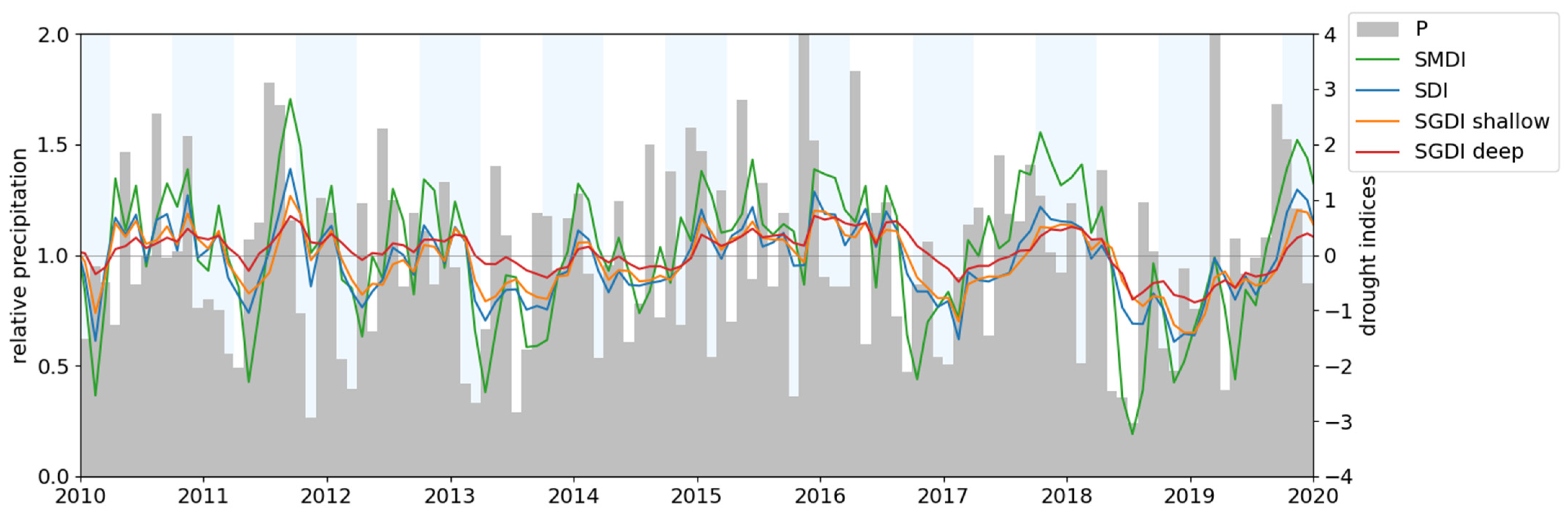
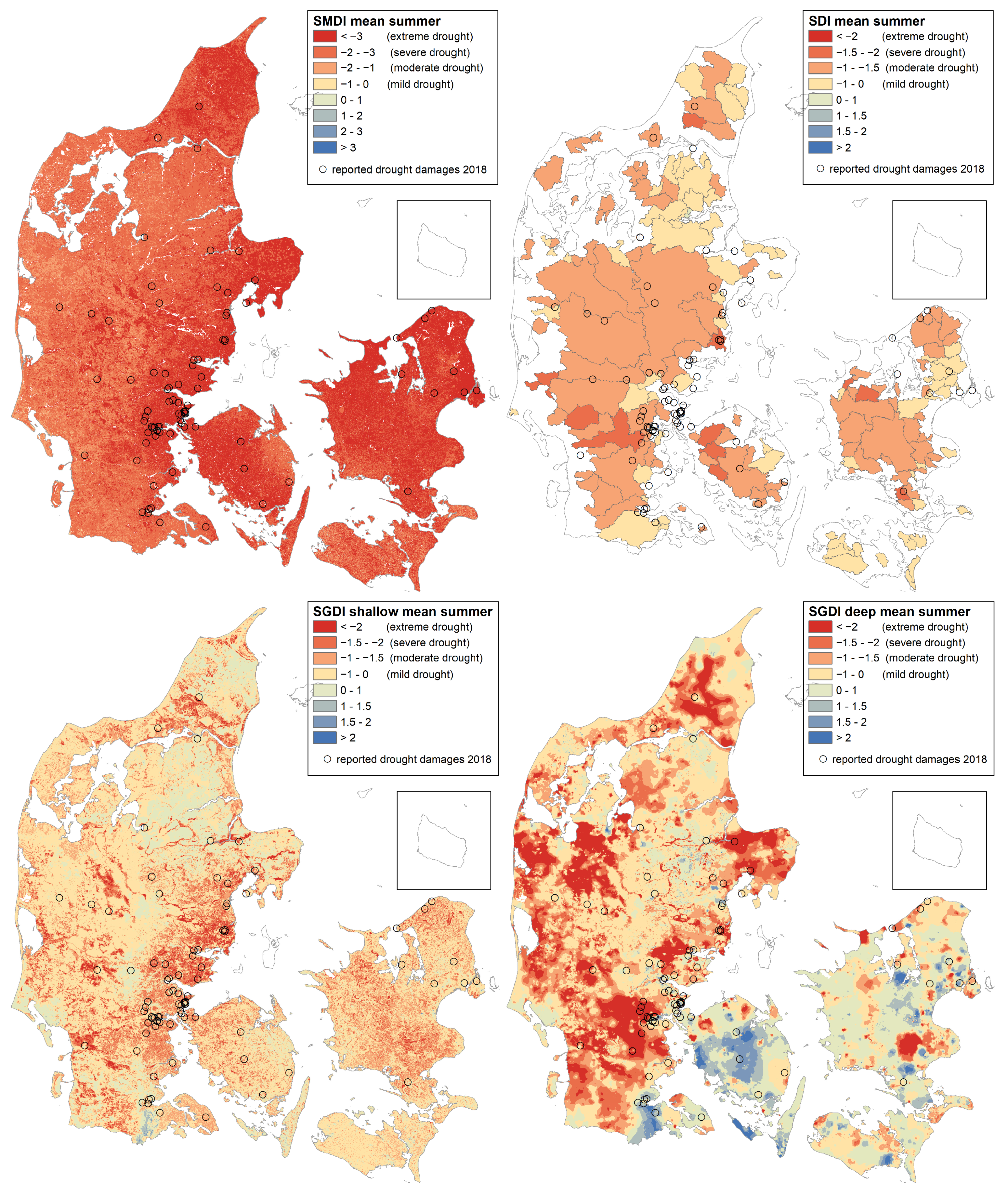
  37. Henriksen, H.J.; Schneider, R.J.M.; Nilsson, B. Analysis of Drought Indicators Based on a National Coupled Hydrological Model. Identification of Drought Events, Propagation of Drought Indices, Aggregation Level and Illustration of How Data from HIP Realtime Model Can Support Vulnerability Assessment for Damages to Houses; (Danmarks og Grønlands Geologiske Undersøgelse Rapport; Vol. 2022, No. 25); GEUS: Copenhagen, Denmark, 2022. [Google Scholar] [CrossRef]
  38. LaBianca, A.; Mortensen, M.H.; Sandersen, P.; Sonnenborg, T.O.; Jensen, K.H.; Kidmose, J. Impact of urban geology on shallow groundwater. Hydrol. Earth Syst. Sci. Discuss. 2022. in review. [Google Scholar] [CrossRef]
  39. Danapour, M.; Fienen, M.N.; Højberg, A.L.; Jensen, K.H.; Stisen, S. Multi-Constrained Catchment Scale Optimization of Groundwater Abstraction Using Linear Programming. Groundwater 2021, 59, 503–516. [Google Scholar] [CrossRef] [PubMed]
  40. Denmark. Biennial Reports (BR). BR 3. National Communication (NC). NC 7. Available online: https://unfccc.int/documents/28946 (accessed on 1 December 2022).
  41. Quintero, F.; Villarini, G.; Prein, A.F.; Zhang, W.; Krajewski, W.F. Discharge and floods projected to increase more than precipitation extremes. Hydrol. Processes 2022, 36, e14738. [Google Scholar] [CrossRef]
  42. Lane, R.A.; Coxon, G.; Freer, J.; Seibert, J.; Wagener, T. A large-sample investigation into uncertain climate change impacts on high flows across Great Britain. Hydrol. Earth Syst. Sci. 2022, 26, 5535–5554. [Google Scholar] [CrossRef]
  43. van der Keur, P.; Henriksen, H.J. Højtstående Grundvand i Byer. REALDANIA. 2022. (in Danish). Available online: https://realdania.dk/publikationer/faglige-publikationer/hoejtstaaende-grundvand-i-byer/hoejstaaende-grundvand-i-byer (accessed on 1 December 2022).
  44. Skov, I.R.; Schneider, N.; Schweiger, G.; Schöggl, J.-P.; Posch, A. Power-to-X in Denmark: An Analysis of Strengths, Weaknesses, Opportunities and Threats. Energies 2021, 14, 913. [Google Scholar] [CrossRef]
  45. EEA. Climate Change as a Threat to Health and Infectious Diseases. EEA Report No 07. 2022. Available online: https://www.eea.europa.eu/publications/climate-change-impacts-on-health/at_download/file (accessed on 1 December 2022).
  46. Mielby, S.; Henriksen, H.J. Hydrogeological studies integrating the climate, fresheater cycle, and catchment geography for the benefit of urban resilience and sustainability. Water 2020, 12, 3324. [Google Scholar] [CrossRef]
  47. Danish EPA. FOHM—Fælles Offentlig Hydrologisk Model. 2019. Available online: https://mst.dk/natur-vand/vand-i-hverdagen/grundvand/grundvandskortlaegning/kortlaegning-2016-2020/fohm-faelles-offentlig-hydrologisk-model/ (accessed on 11 March 2020).
  48. Henriksen, H.J.; Troldborg, L.; Sonnenborg, T.; Højberg, A.L.; Stisen, S.; Kidmose, J.B.; Refsgaard, J.C. Best Practices in Groundwater Modelling (Hydrologisk Geovejledning 2017/1, in Danish). Available online: https://www.geovejledning.dk/gv7/ (accessed on 1 December 2022).
  49. Stisen, S.; Koch, J.; Sonnenborg, T.O.; Refsgaard, J.C.; Bircher, S.; Ringgaard, R.; Jensen, K.H. Moving beyond runoff calibration—Multi-variable optimization of a surface-subsurface-atmosphere model. Hydrol. Processes 2018, 32, 2654–2668. [Google Scholar] [CrossRef]
Figure 1. Cases of high groundwater level and various consequences. Reprinted /adapted with permission from Ref. [25]. Copyright year 2021, Danish EPA.
Water 15 00025 g001
Figure 2. The national web portal and the HIP DT.
Water 15 00025 g002
Figure 3. DK-model HIP. Left: 10 submodels used in recalibration of DK-model HIP 100 m. Central left: 9 soil types. Central right: Land use with 28 vegetation types. Right: Distributed drainage depth [26].
Water 15 00025 g003
Figure 4. High-resolution modeling of winter groundwater level with gradient boost ML algorithm [8].
Water 15 00025 g004
Figure 5. Downscaling of climate change impacts on groundwater level from 500 m to 100 m climate using a random forest ML algorithm Reprinted/adapted with permission from Ref. [8].
Water 15 00025 g005
Figure 6. Monthly anomalies with indices for wetness and droughts, 2010–2019. Precipitation (P). Soil moisture deficit index (SMDI). Streamflow deficit index (SDI). Depth to groundwater table and piezometric head for deep groundwater: standard groundwater level deficit index (SGDI) [37]. The figure and indices illustrate how the meteorological drought cascaded into agricultural and hydrological drought for streamflow and shallow and deep groundwater during the extreme summer drought in Central–Northern Europe and Denmark in 2018–2019.
Water 15 00025 g006
Figure 7. Example of simulated drought indices for Denmark, mean for summer 2018 (JJA). The soil moisture (SMDI) was very dry for the entirety of Denmark situated in the epicenter of this Northern European drought. However, the groundwater (SGDI) was less affected (as it is more dependent on preceding winter conditions) and with more complex distribution for deep groundwater (some areas were wet). Streamflow (SDI) followed a complex mix of SMDI and SGDI shallow and deep [37].
Water 15 00025 g007
Table 1. Definitions of exposure, vulnerability, resilience, and water security (See AR6 WG2 report Summary for Policy makers for definitions of exposure, vulnerability and resilience on page SMP-5–6 in [2] and chapter 4 page 4–8 in [2] for definition on water security.
ExposureThe presence of people; livelihoods; species or ecosystems; environmental functions, services, and resources; infrastructure; or economic, social, or cultural assets in places and settings that could be adversely affected.
VulnerabilityThe propensity or predisposition to be adversely affected. It encompasses a variety of concepts and elements, including sensitivity or susceptibility to harm and lack of capacity to cope and adapt. Key risks have potentially severe adverse consequences for humans and social–ecological systems resulting from the interaction of climate-related hazards with vulnerabilities of societies and systems exposed.
ResilienceThe capacity of social, economic, and ecosystems to cope with a hazardous event or trend or disturbance, responding or reorganizing in ways that maintain their essential function, identity, and structure, as well as biodiversity in the case of ecosystems, while also maintaining the capacity for adaptation, learning, and transformation. Resilience is a positive attribute when it maintains such a capacity for adaptation, learning, and/or transformation.
Water securityThe capacity of a population to safeguard sustainable access to adequate quantities of acceptable quality water for sustaining livelihoods, human wellbeing, and socioeconomic development, for ensuring protection against waterborne pollution and water-related disasters, and for preserving ecosystems in a climate of peace and political stability [3].
Table 2. Relational characteristics of digital twins (modified, adapted from/inspired by Table 1 from [20]).
CharacteristicConceptualization Examples
Real-timeReal-time, current state, dynamic updating, monitoring, not a static representation, boundary conditions to plug-in digital twins.
High-fidelityComprehensive, reliable, represents all digital information, very realistic, mirror, combining information, accurate, information-rich.
PredictivePrediction, prognostics, probabilistic, aggregate future states, continuous forecasting, assimilation; adaptation scenarios.
PrescriptiveImprovement, solve problems, optimization, efficiency, reconfigure, diagnostics, uncover issues, recommend changes, increase lifespan of infrastructure, performance assessment, anomaly detection.
FeedbackIntegration, interaction, bidirectional, entangled relation, fusion, screening, change, seamlessly integrated, mitigating damage or degradation, linked, feedback loop, inverse calibration, decision-making.
Disclaimer/Publisher’s Note: The statements, opinions and data contained in all publications are solely those of the individual author(s) and contributor(s) and not of MDPI and/or the editor(s). MDPI and/or the editor(s) disclaim responsibility for any injury to people or property resulting from any ideas, methods, instructions or products referred to in the content.

