Article

Influence of Spatial Extent on Contemporary and Future Threat Evaluation for Imperiled Fluvial Fishes and Mussels

1
Department of Fisheries and Wildlife, Michigan State University, East Lansing, MI 48824, USA
2
Institute for Fisheries Research, Michigan Department of Natural Resources, University of Michigan, Ann Arbor, MI 48109, USA
*
Author to whom correspondence should be addressed.
Water 2022, 14(21), 3464; https://doi.org/10.3390/w14213464
Submission received: 3 October 2022 / Revised: 17 October 2022 / Accepted: 27 October 2022 / Published: 30 October 2022

Abstract

:
Species conservation often faces many challenges, such as addressing threats from multiple stressor sources, representing under-studied taxa, and understanding implications of spatial extent. To overcome these challenges, we assessed contemporary anthropogenic threats from stream fragmentation and landscape disturbance as well as future habitat suitability under climate change for traditionally well-studied (fishes) and under-studied (mussels) imperiled fluvial taxa in Michigan, USA. To understand how threats to species vary spatially, predicted habitat suitability was analyzed for three hierarchically nested spatial extents: statewide, within species’ biogeographic ranges, and within river patches fragmented by barriers. Comparison of current and future habitat suitability for 27 fish and 23 mussel species indicates large potential statewide gains for many warmwater and/or large river fishes and several mussel species, however these gains are greatly diminished by biogeographic range limitations and habitat fragmentation among current and future habitats. One mussel species and several cold- and coolwater fishes are projected to have significant habitat losses under climate change irrespective of spatial extent. On average, 79% of habitats for mussels and 58% for fishes were considered moderately to severely disturbed from current human landscape activities. Habitat fragmentation was greater for fishes than mussels, with large dams playing a primary role in fragmenting habitats relative to small dams and waterfalls. Results indicate that threat assessments can vary substantially according to spatial extent and taxa, and consideration of both contemporary and future threats to habitats is needed to inform conservation of imperiled fluvial organisms.

1. Introduction

Freshwater biodiversity loss is occurring at alarming rates, with species extinctions and population declines being triggered by an increasing scope and severity of contemporary anthropogenic stressors to aquatic environments and their surrounding landscapes. Habitat degradation resulting from anthropogenic stressors has been identified as a major source of global freshwater biodiversity loss [1], greatly affecting both fishes [2,3] and mussels [4,5,6]. In North America, habitat degradation and range restrictions were identified as primary causes of imperiled fish declines [7] with freshwater mussels being considered the most highly imperiled freshwater taxa [8,9,10]. Similar human stressor-induced declines in fishes and mussels have been observed in many other parts of the globe, such as Europe [11], Latin America [12], and Asia [13]. Beyond the contemporary habitat degradation resulting in these declines, freshwater environments are particularly susceptible to future climate change due to the influence of climatic drivers on both the hydrologic and thermal characteristics of water within these systems [14,15]. Climate change is expected to alter the quality, quantity, and distribution of suitable habitats for many freshwater organisms and further exacerbate the effects of anthropogenic stressors [14,15,16]. These factors put imperiled freshwater species at enormous risk, necessitating conservation assessments that account for both contemporary and future stressor sources.
Freshwater conservation assessments for imperiled species are frequently confronted by a number of common challenges. First, many studies have frequently focused on single stressor sources (e.g., human land uses), while numerous other threats to aquatic biodiversity tend to co-occur (e.g., barriers, water withdrawals, etc.). Omitting other major stressors to aquatic habitats can underrepresent threats for species that are susceptible to influences from multiple anthropogenic stressors [17]. Recent studies suggest that conservation assessments must go beyond focusing on single stressor sources to account for both the independent and synergistic effects of multiple stressors [18]. For instance, studies that focus solely on climate change could ignore contemporary drivers of aquatic habitat degradation (e.g., land use, habitat fragmentation) that are important sources of biodiversity loss [18]. Studies combining contemporary and future stressors demonstrate the importance of distinguishing among drivers of habitat change, allowing for the identification of specific mitigation strategies to counteract the combined effects of multiple stressors [19,20,21]. Consequently, assessing threats from multiple stressors is an essential part of conservation planning, leading to conservation priorities that can differ substantially from those generated when only a single stressor is considered [22,23].
Freshwater conservation assessments are also frequently limited in that they are often conducted for single, charismatic species [24] or alternatively are conducted using species from a well-studied taxon (e.g., fishes). These well-studied taxa are frequently used as surrogates for overall aquatic biodiversity conservation [25], while many other aquatic taxa (mussels, insects, crayfish, etc.) are often understudied or overlooked [26,27]. However, cross-taxon congruence in responses to both natural conditions and anthropogenic stressors in freshwater environments is often weak [28,29,30] leading to diverging priorities in establishing conservation strategies or freshwater protected areas [31]. Studies evaluating multiple taxa have commonly distilled species-level data into species richness metrics with a goal of characterizing broad-scale patterns in freshwater biodiversity or identifying biodiversity hotspots among multiple taxa groups. However, these assessments often lack the species-level specificity that would inform conservation decision-making for individual imperiled species. Thus, taking a multi-taxa approach could further improve understanding of how the conservation of species from one taxon might benefit or possibly neglect conservation opportunities for species in another taxon.
A further challenge in aquatic biodiversity conservation is that research is often removed from implementation, creating a mismatch between the products and knowledge generated through research and the needs of conservation practitioners [16,32]. This includes a mismatch in spatial extent between studies and conservation planning and decision-making [33]. Studies have rarely considered multiple spatial extents [34], despite advantages to conservation planning that incorporates a multi-extent approach [35]. Providing information for a variety of relevant spatial extents can allow for the evaluation of differing context-dependent management options [32] and improve understanding of how threats such as habitat connectivity loss [36] or climate change [37] vary according to spatial extent. Further understanding the similarities and differences in species’ vulnerabilities to specific threats at multiple spatial extents is highly valuable for conservation efforts [38] as the multi-scale patterns at which stressors manifest can differentially affect species conservation [38,39]. Quantifying multiple threats, and the spatial extents at which they manifest, aids in the imperiled species conservation [40] by allowing conservation strategies to be directed toward the appropriate threats and spatial extents [24].
With a goal of providing a more comprehensive threat assessment for imperiled fluvial species that overcomes these common challenges, we conducted a multi-taxa assessment of contemporary and future threats for imperiled fluvial fishes and mussels in Michigan, USA across multiple spatial extents. Specifically, we assessed three major threat types: (1) contemporary landscape-based anthropogenic stressors to habitats, (2) contemporary stream fragmentation among habitats, and (3) future habitat suitability under climate change according to projected stream temperature and stream flow. To understand how threats to species vary spatially, we evaluated these threats at three hierarchically nested spatial extents: statewide, within biogeographic species ranges, and within river patches fragmented by natural and anthropogenic barriers.

2. Materials and Methods

2.1. Study Area, Spatial Framework, and Climate Data

The study area encompassed the state of Michigan, USA (Figure 1), a region providing a unique case study in assessing anthropogenic threats to aquatic taxa due to its glacial history. In particular, glacial influences on the spatial configuration and composition of surficial geology have resulted in diverse stream flow and temperature regimes within the state, ranging from streams with very cold, stable flows to warm, runoff-driven steams with highly variable flows. This glacial history has also greatly affected aquatic habitat connectivity in streams, influencing post-glacial species colonization patterns. These combined factors have contributed to a diverse fluvial fauna, generating conditions that greatly affect species conservation within the state, as southern-distributed species are biogeographically limited and spatially co-vary with anthropogenic landscape disturbance intensity whereas northern-distributed species are often less biogeographically restricted with habitats that often have lower levels of human stressors.
The 1:24,000 National Hydrography Dataset (NHD; U.S. Geological Survey and U.S. Environmental Protection Agency), consisting of ~68,000 inter-confluence stream reaches for Michigan, was the underlying spatial framework in this study. Local catchments, the land area draining directly to a stream reach, and network catchments representing entire upstream drainage areas were attributed with a suite of landscape-based predictors characterizing geology, soils, groundwater discharge, elevation, and climate (Table S1). To understand how climate change might affect fluvial habitats in the future, we incorporated future air temperature and precipitation projections into existing stream flow and temperature models. Three model estimates of stream flow and one model estimate of stream temperature were included to characterize current and future flow and temperature conditions, as both factors have strong influences on fish and mussel distributions within the state [41,42,43]. Stream flow models estimating median annual discharge, April 10% exceedance yield (spring high flow), and August 90% exceedance yield (summer low flow) were utilized in this study to capture overall flow patterns as well as seasonal flow influences [44]. Stream temperature predictions were derived from a July mean stream temperature model [45] using six landscape-based predictor variables including July mean air temperature. The month of July corresponds with the warmest instream temperatures for this region, representing a limiting factor in the distribution of cool- and coldwater fishes [45].
Climate change data were obtained from the Upper Midwest and Great Lakes Landscape Conservation Cooperative and consisted of predicted annual precipitation, mean annual air temperature, and July mean air temperature for mid-century (2046–2065) and late century (2081–2100) periods for 13 climate change models (Table S2). These models were developed under the A1B climate change scenario, representing a balanced use of renewable and non-renewable energy sources moving into the future. As a result, 26 climate change projections (13 models for two time periods) were incorporated into stream flow and temperature models.

2.2. Habitat Suitability Models and Climate Change Projections

Habitat suitability models were developed and used as the basis for contemporary and future threat analyses in this study (Figure 2). Habitat suitability modeling was done with MaxEnt [46] for 27 fluvial fish species and 23 fluvial mussel species considered imperiled in Michigan, USA based on the 2005 State Wildlife Action Plan ([47]; Table S3). A total of 10 fluvial predictor variables were used for habitat suitability modeling (Table S1) representing a set of relatively uncorrelated predictors (Pearson correlation coefficient < 0.5). In addition to three stream flow estimates and one stream temperature estimate (described above), stream reach elevation and slope, local catchment groundwater discharge, and network catchment slope, soil permeability, and percentage of fine-textured surficial geology were used as predictors. We used a 50th percentile training occurrence logistic cutoff to identify highly suitable habitats [43]. This approach was taken to identify core habitats that are critical to long-term species persistence and are of high potential quality from a conservation standpoint. To aid in the interpretation of contemporary and future threats among species, we assigned fishes and mussels to thermal habitat preference guilds based on July mean stream temperatures. Fishes were assigned to thermal guilds based on [48] when available. For fishes lacking thermal guild designations in [48] and for all mussel species, we used predicted July mean stream temperatures (described above) for species occurrences to assign thermal guilds based on the coldwater, coolwater, and warmwater temperature ranges described in [48] (Table S3).
To compare the relative influences of climate change on future habitat suitability predictions, habitat suitability models were projected to future conditions under climate change using both stream flow and stream temperature estimates. These comparisons were done to identify highly suitable habitat that was; (1) retained; predicted to be highly suitable in both the present and future, (2) lost; habitat currently considered highly suitable, but not highly suitable in the future, and (3) gained; habitat not currently considered highly suitable, but highly suitable in the future. The amount of retained, gained, and lost habitat was used to quantify overall (i.e., net) habitat gain or loss relative to current time period predictions. We further compared habitat suitability under climate change at three spatial extents within our spatial framework; (1) statewide; model results for the full statewide set of stream reaches, (2) biogeographic; model results constrained to stream reaches within river basins in that state that contain known species occurrences, and (3) patch; model results restricted to stream reaches within river patches containing contiguous habitat (described below) with known species occurrences that are nested within biogeographic river basins. These three spatial extents provide differing sets of results with distinct relevance to species conservation. Many species assessments are conducted within geopolitical boundaries (e.g., statewide, nationwide, etc.) with this extent being useful for species whose current status (distribution and range) is not well understood. The biogeographic extent refers to river basins where species were known to colonize with river basin boundaries acting as a natural barrier to trans-basin movement. Finally, the patch extent incorporates known barriers within fluvial systems to understand contemporary habitat connectivity in conjunction with future habitat gain/loss under climate change. We present results for all spatial extents; however, additional results focus on the biogeographic extent which is frequently utilized for conservation planning.

2.3. Contemporary Human Landscape Disturbance

To assess current landscape-based anthropogenic threats to fluvial habitats we utilized a comprehensive human landscape disturbance index developed for Michigan streams [49]. This index integrates the influences of 27 anthropogenic stressor sources (e.g., urbanization, agriculture, pollution outfall sites, nutrient inputs) attributed to two spatial zones, catchments and riparian buffers, at both a local scale representing land areas contributing directly to each reach and a network scale representing entire upstream contributing land areas. This index was calibrated using biological responses to disturbances [49], with values ranging from 0 to 100 with values of 100 representing most-disturbed conditions. Breakpoints in fish abundance across a gradient of the landscape disturbance index were developed using piecewise regression [50,51] to identify low, moderate, and severe landscape disturbance classes (Figure S1). For 404 statewide single-pass electrofishing samples across the human landscape disturbance index gradient, we summed individual species catch per unit effort (log (x + 1) where x corresponds to the number of individuals captured per 100 m of stream length) to develop total imperiled stream fish catch per unit effort. This analysis resulted in low (x < 4.08), moderate (4.08 ≤ x < 11.65), and high (x ≥ 11.65) landscape disturbance classes (Figure S1). We were unable to identify landscape disturbance breakpoints for mussels because abundance data for mussels were not available. Consequently, we characterized low, medium, and severe levels of landscape disturbance using the breakpoints identified for stream fishes. Therefore, for this analysis, we assumed that mussel and fish responses to disturbances were similar. However, this may not be an unreasonable assumption because Unionid mussels are dependent on obligate fish host species and fish host characteristics can influence mussel distributions [35].

2.4. Contemporary Stream Fragmentation

The amount of stream fragmentation for each species was quantified using a barrier dataset containing large dams generally > 2 m in height from the National Anthropogenic Barrier Dataset (NABD) [52], small dams from a state agency database (Michigan Department of Environment, Great Lakes, and Energy; unpublished data), and waterfall locations representing naturally occurring barriers [53]. Barrier locations were used to delineate patches which represent contiguous sections of stream network that are connected between barrier locations [54]. These stream patches formed the spatial units in calculating the Dendritic Connectivity Index (DCI) [55], which measures connectivity among patches within river basins, incorporating the passability of barriers between patches and the total amount of habitat available among patches within each river basin. Total length of highly suitable habitat within patches for each species was used as the unit of length measurement in calculating the DCI. This approach provided a measure of connectivity among highly suitable locations tailored to each species as opposed to a generic measure of connectivity where connectivity among all stream reaches is considered irrespective of species habitat suitability. For this analysis, all barriers were considered impassable (i.e., passability set to zero). DCI values range from 0 to 100, with 100 representing fully passable (completely unfragmented) systems whereas low DCI values indicate a low degree of connectivity and a high degree of habitat fragmentation [55,56]. To compare habitat fragmentation conditions among barrier types, four DCI values were calculated for each species: large dams only, small dams only, waterfalls only, and all barriers combined. DCI values for the ‘waterfalls only’ results provided a natural connectivity baseline from which to assess anthropogenic connectivity loss due to dam construction. We split the DCI value range into thirds to create low (x ≥ 66.66), moderate (33.33 ≤ x < 66.66), and high (x < 33.33) fragmentation classes. Calculations were implemented in R (R 3.0.3; R Core Team, Vienna, Austria) with code from the Fish Passage Extension (FIPEX v2.2.1; Fisheries and Oceans Canada).

2.5. Combining Contemporary and Future Threats

To visualize and evaluate multiple dimensions of anthropogenic threat to species, we graphed overall conditions among three threat axes: future habitat suitability under climate change, current human landscape disturbance, and current habitat fragmentation. Three-dimensional graphs were generated by scaling species’ threats from 0 (low relative threat) to 1 (high relative threat) for each taxa group. For climate change, the total amount of highly suitable habitat predicted for each species based on median mid-century projections was rescaled into an index ranging from 0 to 1, with values of 1 indicating high potential habitat loss potential within a taxa group. For human landscape disturbance conditions, we used the proportion of highly suitable habitat predicted under current climate conditions within the moderate and severe disturbance classes for each species. For fragmentation conditions among habitats, we used stream length-weighted average DCI index values (represented as a 0 to 1 scale) generated using all barriers for each species based on highly suitable habitat predictions under current climate conditions. We plotted species scores among the three indices in three-dimensional space according to the Red-Green-Blue (RGB) color system, with Red color values representing current landscape disturbance, Blue color values representing fragmentation, and Green color values representing future habitat suitability. Graphing in this way allowed us to visualize the influence of multiple threats simultaneously to identify individual species or groups of species with unique threat combinations. These scores were further mapped using occurrence locations for each species to identify spatial patterns of threats associated with the distributions of fish and mussel species.

3. Results

3.1. Contemporary Human Landscape Disturbance

The amount of landscape disturbance associated with highly suitable habitat for fish and mussels varied by species and spatial extent (Figure S2). In particular, the percentage of highly suitable habitat with low levels of landscape disturbance either increased (e.g., pugnose shiner (Notropis anogenus)) or decreased (e.g., eastern pondmussel (Ligumia nasuta)) for certain species across the statewide, biogeographic, and patch spatial extents (Figure S2). A similar pattern was evident for habitat with severe landscape disturbance, with species exhibiting increasing (e.g., pirate perch (Aphredoderus sayanus)) or decreasing (e.g., clubshell (Pleurobema clava)) levels across extents. In general, higher levels of human landscape disturbance occurred in mussel habitats compared to fish habitats at the biogeographic extent (Figure S2) with 79% and 58% of habitats moderately to severely disturbed on average for mussels and fishes, respectively (Table S4). Two stream fishes, redside dace (Clinostomus elongatus) and eastern sand darter (Ammocrypta pellucida), and seven mussel species had > 90% of highly suitable habitats that are moderately to severely disturbed at the biogeographic extent, indicating extreme threat from contemporary anthropogenic landscape alteration for these species (Table S4). Conversely, two stream fishes, finescale dace (Phoxinus neogaeus) and slimy sculpin (Cottus cognatus) had > 90% of highly suitable habitat classified as low disturbance while ellipse (Venustaconcha ellipsiformis) and black sandshell (Ligumia recta) had the highest levels of habitat in the low disturbance class among mussels at 48% and 44%, respectively.

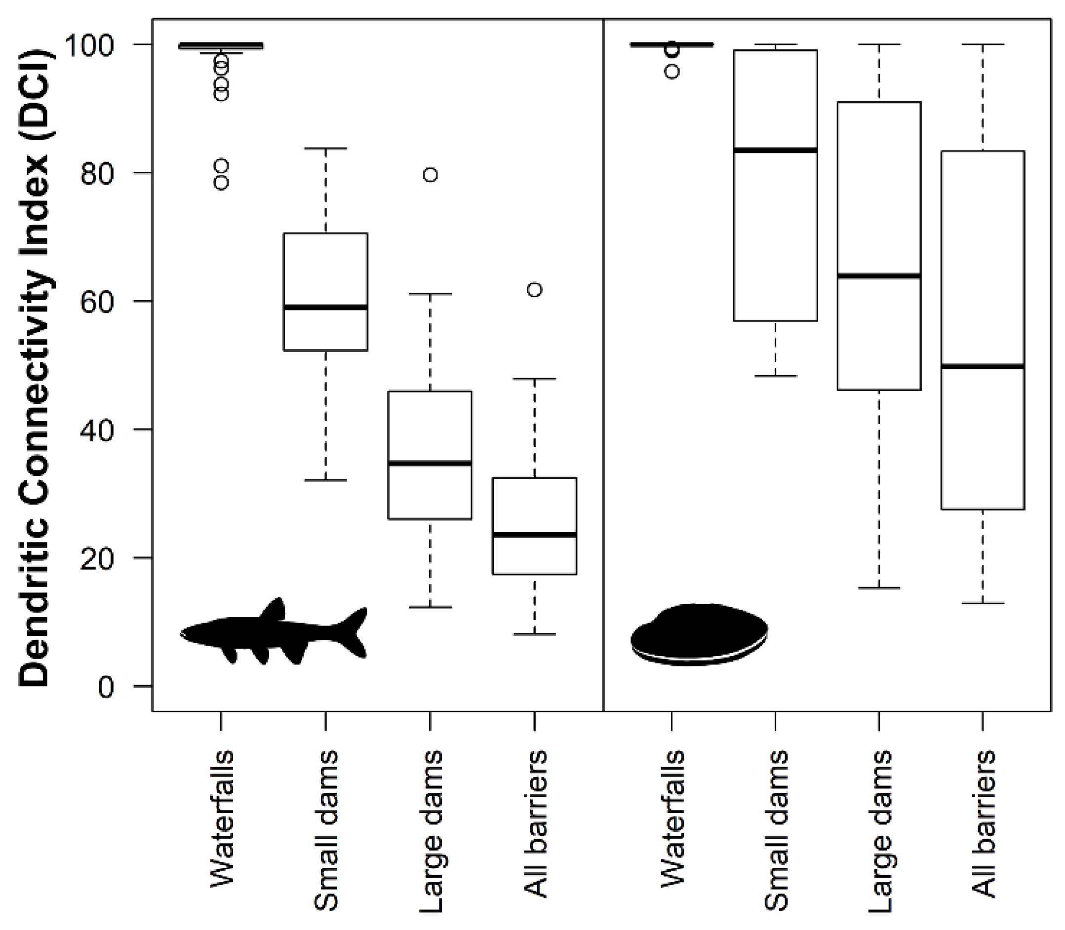
3.2. Contemporary Stream Habitat Fragmentation

Species-level habitat fragmentation levels and overall taxa-level fragmentation patterns differed by spatial extent (Figure S3). For mussels, percentage of highly suitable habitat with low to moderate fragmentation was typically greatest at the patch extent, with levels of severe fragmentation increasing among the biogeographic and statewide extents. Most fish species had the greatest percentage of low to moderately fragmented habitat at either statewide or patch extent with the biogeographic extent generally having the highest levels of severe fragmentation. Highly suitable habitats for mussels were generally less fragmented than fish habitats among spatial extents, with four mussel species, deertoe (Truncilla truncata), fawnsfoot (Truncilla donaciformis), pink papershell (Potamilus ohiensis), and threehorn wartyback (Obliquaria reflexa) having no connectivity loss due to fragmentation by barriers regardless of spatial extent considered. Stream fishes had high levels of fragmentation overall, including species that exhibit potamodromous migratory patterns [57], such as black redhorse (Moxostoma duquesnei), river redhorse (Moxostoma carinatum), and lake chubsucker (Erimyzon sucetta). At the biogeographic extent, Dendritic Connectivity Index (DCI) values averaged 26.4 (range 8.1–61.8) for stream fishes and 56.6 for mussels (range 12.9–100.0) when all barriers were considered (Table S4). Analysis of habitat connectivity by barrier type indicated that large dams were the primary source of connectivity loss for the majority of fish and mussel species (41 of 46 species with DCI < 100; Figure 3). Small dams were a primary contributor to connectivity losses for the five remaining species with DCI < 100, while waterfalls played either a minor or no role in connectivity loss for most species (Table S5).

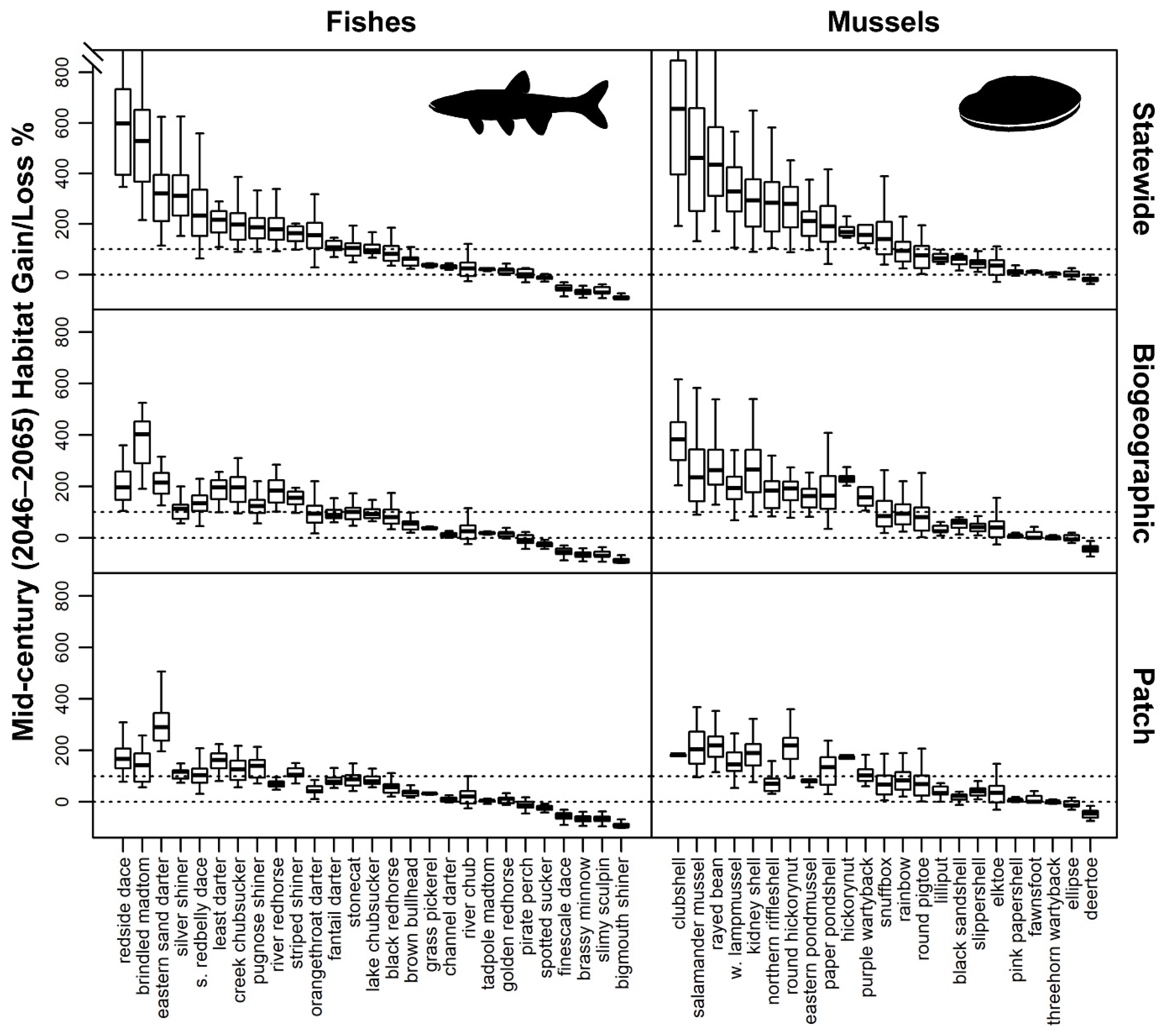
3.3. Future Habitat Suitability under Climate Change

Projected regional increases in future air temperature and precipitation resulted in general statewide increases in estimates of stream flow and temperature under climate change (Table 1). Climate change estimates indicate an overall rise in average July stream temperatures of 1.6 degrees Celsius by mid-century and 2.1 degrees Celsius by late century, representing increases of 9% and 12% from current predictions. Median annual discharge is expected to increase by 36% on average by mid-century and 56% by late century. While estimates indicate minimal increases in high flow yield with climate change, low flow yield is expected to double by late century (Table 1).
The amount of suitable habitat projected under climate change relative to current predictions varied greatly among species and across statewide, biogeographic, and patch spatial extents (Figure 4). In general, mussels were projected to experience greater habitat gains and fishes were projected to experience greater habitat losses across all spatial extents examined. Fishes with projected increases in suitable habitat by mid-century had an average net gain of 194% when future habitat suitability model predictions were applied at a statewide extent. Average habitat gains for fishes dropped to 126% when future habitat suitability predictions were restricted to the biogeographic extent. When habitat suitability predictions were further restricted to the patch extent, average net gains in habitat were less than half the gains predicted for the statewide extent at 96%, but still represented, on average, nearly a doubling of the amount of suitable habitat currently available. A similar pattern was observed for mussel species projected to experience increases in suitable habitat by mid-century. Average net gains were 296% when habitat suitability models were applied to the statewide extent, dropped to 180% when model predictions were restricted to the biogeographic extent, and were lowest at 126% when model predictions were restricted to the patch extent. In contrast, results for species expected to experience habitat losses under climate change did not differ greatly when habitat suitability predictions were applied at different spatial extents. Average net habitat losses for fishes were 49%, 52%, and 52% and average net habitat losses for mussel species were 10%, 24%, and 23% for statewide, biogeographic, and patch spatial extents.
Individual species projections at the biogeographic extent indicated that 21 fish species are projected to have net habitat gains while six species were expected to sustain net losses based on climate change results for the 2046–2065 (mid-century) and 2081–2100 (late century) time periods (Table S5). Nine stream fish species had at least one mid-century climate model projecting a net loss of highly suitable habitat, including cold- and coolwater species such as slimy sculpin, finescale dace, brassy minnow (Hybognathus hankinsoni), and river chub (Nocomis micropogon). For mussels, deertoe is projected to have 47% and 14% of current habitat by mid- and late century. Two additional species, black sandshell and lilliput (Toxolasma parvum), are projected to retain < 30% of current habitat by late century. However, projected habitat gains for both species result in comparable overall amounts of highly suitable between current and future time periods. Most mussel species are projected to retain a large majority of current habitat as well gain new habitats, resulting in large potential future habitat increases. Overall, most of the habitat suitability gains and losses for fish and mussel species occurred by mid-century with minor gains and losses occurring between the mid- and late century periods (Table S5).

3.4. Combining Contemporary and Future Threats

Graphing threats based on future climate change, current human landscape disturbance, and current stream fragmentation revealed distinct multi-dimensional threat patterns both within and across taxa groups (Figure 5a and Figure 6a). Fish species with similar overall threats tended to have similar geographic distributions. For instance, stream fishes with lower human landscape disturbance and fragmentation threats, but with high climate change threat were distributed across the northern half of the state (Figure 5b). Conversely stream fishes with high human landscape disturbance and fragmentation threats, but with low climate change threat were primarily distributed in the extreme southern and southeastern portions of the state. Mussels tended to have lower fragmentation threat than fishes, yet higher threats from human landscape disturbance with most mussel species having low to moderate threats from climate change. In contrast to stream fish occurrences, mussel species with higher threat from climate change were distributed throughout the state (Figure 6b).

4. Discussion

Contemporary anthropogenic disturbances are a key driver of species imperilment and loss for many freshwater organisms, and coupled with climate change, they create an uncertain future for many species. This work provides a novel assessment addressing the influences of spatial extent on assessment of contemporary and future threats for two fluvial taxa with differing habitat and life history requirements. We identified three major findings in this study. First, we found that the potential influence of an individual threat varied between mussels and fishes and among species within taxa. Second, the dominant threat type often varied by taxa and species such that unique threat patterns emerged when multiple stressors were considered simultaneously. Finally, we found that our threat assessment results were sensitive to the spatial extent across which they were applied.

4.1. Incorporating Multiple Taxa in Threat Assessments vs. Use of a Surrogate Taxon

This study illustrates the importance of considering multiple taxa and species in threat assessments and is consistent with a growing number of observations that assessments based on a focal or surrogate taxon may not be representative of threats faced by other taxa [20,21,58,59,60,61]. For instance, predicted fish habitats were generally more fragmented by barriers than predicted mussel habitats, however a greater percentage of mussel habitats were categorized as moderately to highly disturbed from human landscape alteration than fish habitats when accounting for spatial extent. Further, species within a taxon often exhibited varying degrees of threat such that threat assessments based on one or a handful of species would not likely be representative of a taxon as a whole. These results indicate that multi-taxa assessments will be instrumental in developing holistic conservation strategies for imperiled fluvial species. Evaluation of species-specific threats across taxa leads to more accurate threat assessment and spatial identification of appropriate management actions and species-level conservation targets. This includes identifying spatial overlap in habitats where conservation efforts could benefit multiple imperiled species and taxa.

4.2. Assessing Multiple Contemporary and Future Threats

Consideration of multiple threat types has been increasingly identified as an important component in the conservation of fluvial organisms and their habitats [62,63,64,65]. In the current study, evaluating one threat type in the absence of evaluating other threats would have yielded an incomplete picture of the threats imperiled species are facing within the study region. For instance, contemporary conditions including human landscape disturbance and habitat fragmentation suggest that finescale dace, brassy minnow, and slimy sculpin have least-disturbed and relatively unfragmented stream habitats compared to other imperiled stream fishes, however climate change projections indicate that they are the most vulnerable stream fishes to future habitat losses. Conversely, other species such as redside dace, silver shiner (Notropis photogenis), and brindled madtom (Noturus miurus) are anticipated to have large gains in habitats according to climate change projections, yet these species have the highest levels of human landscape disturbance among habitats with projected future habitats being similarly degraded. These examples show that by including multiple threats, both dominant threats and unique combinations of threats, which often vary by taxa and species, can be identified. By combining multiple threats in the current study, interpretation of climate change projections could be achieved in the context of stream fragmentation and landscape disturbance. This can lead to the prioritization of habitats with low to moderate landscape disturbances that are retained in the future.

4.3. Influence of Spatial Extent on Threat Assessments for Imperiled Fluvial Species

We found a high degree of variability in threats to imperiled fluvial species with results from this study indicating that levels of contemporary landscape disturbance and fragmentation along with future climate change projections can vary drastically depending upon the extent the results are analyzed. This resulted from applying habitat suitability models to different spatial extents but can also result when grain size is varied [66,67]. Conservation area selection can be strongly influenced by the spatial extent of the analysis [67]. While this is unsurprising, it underscores that choice of analysis spatial extent requires careful consideration. We stress that results from no single individual extent represented in the current study (statewide, biogeographic, or patch) should be considered “correct,” but instead the choice of appropriate extent(s) to assess threats to imperiled species must be determined based on intended uses and perceived completeness of species occurrence and range information [68]. For instance, the statewide model results may not accurately depict the magnitude of threats a species faces within its current range, and this has the potential to over predict habitat gains with climate change. However, statewide results would be useful if the known range for a particular species is expected to be larger than what is currently identified due to limited field survey data and can assist in targeted surveys or assisted migration (i.e., translocation; [69,70]). Biogeographic results encompassing habitat changes for river basins with known species occurrences could provide a realistic starting point when evaluating threats among many individual species, however it assumes that a species can disperse throughout its range and potentially gain access to new habitats under climate change. This extent may be useful for identifying barrier mitigation opportunities and quantifying the amount and condition of new habitat that may become available as a result of barrier mitigation. Lastly, for species with well-documented distributions and known sensitivities to habitat connectivity loss, the patch extent can provide information for individual populations and can guide decisions regarding population-level habitat restoration. Applying habitat suitability models at the patch extent may provide the most accurate threat assessment where a species is likely to occur, but assumes that a species is not able to move among patches.
Climate change projections in this study suggest large shifts in habitat suitability for many species by mid-century with most warmwater fishes gaining habitats while cool- and coldwater species [48] are expected to suffer habitat losses. Similar trends have been predicted in other climate change assessments [71] as well as studies documenting historic range shifts due to changing climates in northern regions over recent millennia [29]. Although climate change projections indicate habitat gains for many warmwater stream fishes, these gains are subject to connectivity constraints imposed by biogeography (i.e., patterns of post-glacial species colonization) and/or anthropogenic and natural barriers to fish movement. Many studies have examined the potential influence of climate on stream fish assemblages; however, most have implicitly assumed that fish dispersal within river networks will be unrestricted. By accounting for the effects of barriers on connectivity between current and future habitats (i.e., patch spatial extent in the current study), a more realistic outcome of the effects of climate change can be evaluated, particularly for species expected to gain habitats in the future. This suggests the conservation of diverse habitats [72] and promoting connectivity to increase patch sizes and habitat availability will be crucial to enhancing ecological resilience [73] in order to offset habitat losses due to climate change.

5. Conclusions

Freshwater taxa are facing a myriad of contemporary and future threats. Assessments that include multiple species and taxa will provide the most robust picture of threats imperiled fluvial species are facing. Further, assessment of multiple threats holistically as opposed to independently can lead to threat evaluations that can differ substantially from those generated when only one threat is considered. Spatial extent can greatly affect threat assessment and thus necessitates careful determination of the spatial extent(s) at which threats will be evaluated in conservation planning. Multiple threats, and the spatial extent at which they are assessed, will need to be considered simultaneously when developing conservation plans for imperiled fluvial aquatic species.

Supplementary Materials

The following supporting information can be downloaded at: https://www.mdpi.com/article/10.3390/w14213464/s1, Figure S1: Breakpoints along the human landscape disturbance index for imperiled stream fish catch per unit effort identified with piecewise regression. Vertical dashed lines indicate cutoffs defined for low, moderate, and severe disturbance classes. Horizontal solid lines represent the 95% confidence intervals for each breakpoint; Figure S2: Percentage of predicted stream length within the low (blue), moderate (orange), and high (red) human landscape disturbance classes for statewide, biogeographic, and patch spatial extents; Figure S3: Percentage of predicted stream length within the low (black), moderate (dark gray), and high (light gray) fragmentation classes for statewide, biogeographic, and patch spatial extents; Table S1: Stream predictor variables used in development of habitat suitability models [44,74,75,76,77,78]; Table S2: Climate change models under the A1B scenario incorporated into stream flow and stream temperature models; Table S3: Fish and mussel common names, scientific names, thermal guild, and number of fluvial occurrences used in habitat suitability models. *Thermal guilds derived from predicted July mean stream temperatures. All other thermal guilds are based on Lyons et al. 2009 (see Methods).; Table S4: Predicted amount of highly suitable habitat within the biogeographic extent under climate change using median MaxEnt model climate change projections for the mid-century (2046–2065) and late century (2081–2100) time periods. See Methods for definitions of habitat held, loss, and gain. All percentages are relative to the current amount of highly suitable habitat with net results accounting for predicted habitat gains and losses; Table S5: Summary of contemporary disturbances to highly suitable stream habitats within the biogeographic extent. Anthropogenic landscape disturbance values represent the percentage of habitat length within the low, moderate, high landscape disturbance categories. Dendritic Connectivity Index (DCI) values were calculated as a stream reach length-weighted average. DCI values range from 0 to 100 with value of 100 indicating full connectivity among habitats.

Author Contributions

Conceptualization, A.R.C. and K.E.W.; methodology, A.R.C. and K.E.W.; formal analysis, A.R.C.; data curation, S.-K.Y.; writing—original draft preparation, A.R.C.; writing—review and editing, K.E.W., S.-K.Y. and D.M.I.; visualization, A.R.C.; supervision, K.E.W. and D.M.I.; project administration, K.E.W.; funding acquisition, K.E.W. and D.M.I. All authors have read and agreed to the published version of the manuscript.

Funding

This research was funded by the Michigan Department of Natural Resources and the State Wildlife Grant Program (Grant T-10) with in-kind support provided by Michigan State University AgBioResearch. The APC was funded by the Michigan Department of Natural Resources.

Institutional Review Board Statement

Not applicable.

Informed Consent Statement

Not applicable.

Data Availability Statement

Data presented in this study are available upon reasonable request from the corresponding author. Locations of threatened and endangered species in this study are considered sensitive by the agencies providing these data and thus are not publicly available.

Acknowledgments

We thank Jana Stewart and the Upper Midwest and Great Lakes Landscape Conservation Cooperative for providing climate change data, Travis Brenden for providing stream temperature predictions, Daniel Wieferich for providing waterfall locations, and the Michigan Natural Features Inventory (MNFI) for providing mussel occurrence data.

Conflicts of Interest

The authors declare no conflict of interest. The funders had no role in the design of the study; in the collection, analyses, or interpretation of data; in the writing of the manuscript, or in the decision to publish the results.

References

  1. Dudgeon, D.; Arthington, A.H.; Gessner, M.O.; Kawabata, Z.I.; Knowler, D.J.; Lévêque, C.; Naiman, R.J.; Prieur-Richard, A.H.; Soto, D.; Stiassny, M.L.; et al. Freshwater biodiversity: Importance, threats, status and conservation challenges. Biol. Rev. 2006, 81, 163–182. [Google Scholar] [CrossRef] [PubMed]
  2. Su, G.; Logez, M.; Xu, J.; Tao, S.; Villéger, S.; Brosse, S. Human impacts on global freshwater fish biodiversity. Science 2021, 371, 835–838. [Google Scholar] [CrossRef] [PubMed]
  3. He, F.; Zarfl, C.; Bremerich, V.; David, J.N.; Hogan, Z.; Kalinkat, G.; Tockner, K.; Jähnig, S.C. The global decline of freshwater megafauna. Glob. Chang. Biol. 2019, 25, 3883–3892. [Google Scholar] [CrossRef]
  4. Lydeard, C.; Cowie, R.H.; Ponder, W.F.; Bogan, A.E.; Bouchet, P.; Clark, S.A.; Cummings, K.S.; Frest, T.J.; Gargominy, O.; Herbert, D.G.; et al. The global decline of nonmarine mollusks. BioScience 2004, 54, 321–330. [Google Scholar] [CrossRef]
  5. Lopes-Lima, M.; Burlakova, L.E.; Karatayev, A.Y.; Mehler, K.; Seddon, M.; Sousa, R. Conservation of freshwater bivalves at the global scale: Diversity, threats and research needs. Hydrobiologia 2018, 810, 1–14. [Google Scholar] [CrossRef] [Green Version]
  6. Ferreira-Rodríguez, N.; Akiyama, Y.B.; Aksenova, O.V.; Araujo, R.; Barnhart, M.C.; Bespalaya, Y.V.; Bogan, A.E.; Bolotov, I.N.; Budha, P.B.; Clavijo, C.; et al. Research priorities for freshwater mussel conservation assessment. Biol. Conserv. 2019, 231, 77–87. [Google Scholar] [CrossRef] [Green Version]
  7. Jelks, H.L.; Walsh, S.J.; Burkhead, N.M.; Contreras-Balderas, S.; Diaz-Pardo, E.; Hendrickson, D.A.; Lyons, J.; Mandrak, N.E.; McCormick, F.; Nelson, J.S.; et al. Conservation status of imperiled North American freshwater and diadromous fishes. Fisheries 2008, 33, 372–407. [Google Scholar] [CrossRef]
  8. Wilcove, D.S.; Rothstein, D.; Dubow, J.; Phillips, A.; Losos, E. Quantifying threats to imperiled species in the United States. BioScience 1998, 48, 607–615. [Google Scholar] [CrossRef] [Green Version]
  9. Williams, J.D.; Warren, M.L., Jr.; Cummings, K.S.; Harris, J.L.; Neves, R.J. Conservation status of freshwater mussels of the United States and Canada. Fisheries 1993, 18, 6–22. [Google Scholar] [CrossRef]
  10. Strayer, D.L.; Downing, J.A.; Haag, W.R.; King, T.L.; Layzer, J.B.; Newton, T.J.; Nichols, J.S. Changing perspectives on pearly mussels, North America’s most imperiled animals. BioScience 2004, 54, 429–439. [Google Scholar] [CrossRef]
  11. Lopes-Lima, M.; Sousa, R.; Geist, J.; Aldridge, D.C.; Araujo, R.; Bergengren, J.; Bespalaya, Y.; Bódis, E.; Burlakova, L.; Van Damme, D.; et al. Conservation status of freshwater mussels in Europe: State of the art and future challenges. Biol. Rev. 2017, 92, 572–607. [Google Scholar] [CrossRef] [PubMed] [Green Version]
  12. Pelicice, F.M.; Azevedo-Santos, V.M.; Vitule, J.R.; Orsi, M.L.; Lima Junior, D.P.; Magalhães, A.L.; Pompeu, P.S.; Petrere, M., Jr.; Agostinho, A.A. Neotropical freshwater fishes imperilled by unsustainable policies. Fish Fish. 2017, 18, 1119–1133. [Google Scholar] [CrossRef]
  13. Zieritz, A.; Bogan, A.E.; Froufe, E.; Klishko, O.; Kondo, T.; Kovitvadhi, U.; Kovitvadhi, S.; Lee, J.H.; Lopes-Lima, M.; Pfeiffer, J.M.; et al. Diversity, biogeography and conservation of freshwater mussels (Bivalvia: Unionida) in East and Southeast Asia. Hydrobiologia 2018, 810, 29–44. [Google Scholar] [CrossRef]
  14. Palmer, M.A.; Lettenmaier, D.P.; Poff, N.L.; Postel, S.L.; Richter, B.; Warner, R. Climate change and river ecosystems: Protection and adaptation options. Environ. Manag. 2009, 44, 1053–1068. [Google Scholar] [CrossRef]
  15. Woodward, G.; Perkins, D.M.; Brown, L.E. Climate change and freshwater ecosystems: Impacts across multiple levels of organization. Philos. T. R. Soc. B 2010, 365, 2093–2106. [Google Scholar] [CrossRef] [Green Version]
  16. Strayer, D.L.; Dudgeon, D. Freshwater biodiversity conservation: Recent progress and future challenges. J. N. Am. Benthol. Soc. 2010, 29, 344–358. [Google Scholar] [CrossRef] [Green Version]
  17. Ormerod, S.J.; Dobson, M.; Hildrew, A.G.; Townsend, C. Multiple stressors in freshwater ecosystems. Freshw. Biol. 2010, 55, 1–4. [Google Scholar] [CrossRef]
  18. Titeux, N.; Henle, K.; Mihoub, J.B.; Regos, A.; Geijzendorffer, I.R.; Cramer, W.; Verburg, P.H.; Brotons, L. Biodiversity scenarios neglect future land-use changes. Glob. Chang. Biol. 2016, 22, 2505–2515. [Google Scholar] [CrossRef] [Green Version]
  19. Nelson, K.C.; Palmer, M.A.; Pizzuto, J.E.; Moglen, G.E.; Angermeier, P.L.; Hilderbrand, R.H.; Dettinger, M.; Hayhoe, K. Forecasting the combined effects of urbanization and climate change on stream ecosystems: From impacts to management options. J. Appl. Ecol. 2009, 46, 154–163. [Google Scholar] [CrossRef] [Green Version]
  20. Mantyka-Pringle, C.S.; Martin, T.G.; Moffatt, D.B.; Udy, J.; Olley, J.; Saxton, N.; Sheldon, F.; Bunn, S.E.; Rhodes, J.R. Prioritizing management actions for the conservation of freshwater biodiversity under changing climate and land-cover. Biol. Conserv. 2016, 197, 80–89. [Google Scholar] [CrossRef]
  21. Radinger, J.; Hölker, F.; Horký, P.; Slavík, O.; Dendoncker, N.; Wolter, C. Synergistic and antagonistic interactions of future land use and climate change on river fish assemblages. Glob. Chang. Biol. 2016, 22, 1505–1522. [Google Scholar] [CrossRef]
  22. Kennedy, C.M.; Oakleaf, J.R.; Theobald, D.M.; Baruch-Mordo, S.; Kiesecker, J. Managing the middle: A shift in conservation priorities based on the global human modification gradient. Glob. Chang. Biol. 2019, 25, 811–826. [Google Scholar] [CrossRef] [PubMed]
  23. Rojas, I.M.; Jennings, M.K.; Conlisk, E.; Syphard, A.D.; Mikesell, J.; Kinoshita, A.M.; West, K.; Stow, D.; Storey, E.; De Guzman, M.E.; et al. A landscape-scale framework to identify refugia from multiple stressors. Conserv. Biol. 2022, 36, e13834. [Google Scholar] [CrossRef] [PubMed]
  24. Geist, J. Integrative freshwater ecology and biodiversity conservation. Ecol. Indic. 2011, 11, 1507–1516. [Google Scholar] [CrossRef]
  25. Olden, J.D.; Kennard, M.J.; Leprieur, F.; Tedesco, P.A.; Winemiller, K.O.; García-Berthou, E. Conservation biogeography of freshwater fishes: Recent progress and future challenges. Divers. Distrib. 2010, 16, 496–513. [Google Scholar] [CrossRef]
  26. Strayer, D.L. Challenges for freshwater invertebrate conservation. J. N. Am. Benthol. Soc. 2006, 25, 271–287. [Google Scholar] [CrossRef]
  27. Collier, K.J.; Probert, P.K.; Jeffries, M. Conservation of aquatic invertebrates: Concerns, challenges and conundrums. Aquat. Conserv. 2016, 26, 817–837. [Google Scholar] [CrossRef]
  28. Infante, D.M.; David Allan, J.; Linke, S.; Norris, R.H. Relationship of fish and macroinvertebrate assemblages to environmental factors: Implications for community concordance. Hydrobiologia 2009, 623, 87–103. [Google Scholar] [CrossRef] [Green Version]
  29. Heino, J.; Virkkala, R.; Toivonen, H. Climate change and freshwater biodiversity: Detected patterns, future trends and adaptations in northern regions. Biol. Rev. 2009, 84, 39–54. [Google Scholar] [CrossRef]
  30. Oikonomou, A.; Stefanidis, K. α-and β-diversity patterns of macrophytes and freshwater fishes are driven by different factors and processes in lakes of the unexplored southern Balkan biodiversity hotspot. Water 2020, 12, 1984. [Google Scholar] [CrossRef]
  31. Stewart, D.R.; Underwood, Z.E.; Rahel, F.J.; Walters, A.W. The effectiveness of surrogate taxa to conserve freshwater biodiversity. Conserv. Biol. 2018, 32, 183–194. [Google Scholar] [CrossRef] [PubMed]
  32. Linke, S.; Turak, E.; Nel, J. Freshwater conservation planning: The case for systematic approaches. Freshw. Biol. 2011, 56, 6–20. [Google Scholar] [CrossRef]
  33. Du Toit, J.T. Considerations of scale in biodiversity conservation. Anim. Conserv. 2010, 13, 229–236. [Google Scholar] [CrossRef]
  34. Razgour, O.; Hanmer, J.; Jones, G. Using multi-scale modelling to predict habitat suitability for species of conservation concern: The grey long-eared bat as a case study. Biol. Conserv. 2011, 144, 2922–2930. [Google Scholar] [CrossRef] [Green Version]
  35. Cheok, J.; Weeks, R.; Pressey, R.L. Identifying the strengths and weaknesses of conservation planning at different scales: The Coral Triangle as a case study. Ecol. Soc. 2019, 24, 24. [Google Scholar] [CrossRef] [Green Version]
  36. Hermoso, V.; Kennard, M.J.; Linke, S. Integrating multidirectional connectivity requirements in systematic conservation planning for freshwater systems. Divers. Distrib. 2012, 18, 448–458. [Google Scholar] [CrossRef] [Green Version]
  37. Game, E.T.; Lipsett-Moore, G.; Saxon, E.; Peterson, N.; Sheppard, S. Incorporating climate change adaptation into national conservation assessments. Glob. Chang. Biol. 2011, 17, 3150–3160. [Google Scholar] [CrossRef]
  38. Schwenk, W.S.; Donovan, T.M. A multispecies framework for landscape conservation planning. Conserv. Biol. 2011, 25, 1010–1021. [Google Scholar] [CrossRef]
  39. Poiani, K.A.; Richter, B.D.; Anderson, M.G.; Richter, H.E. Biodiversity conservation at multiple scales: Functional sites, landscapes, and networks. BioScience 2000, 50, 133–146. [Google Scholar] [CrossRef] [Green Version]
  40. Quist, M.C.; Rahel, F.J.; Hubert, W.A. Hierarchical faunal filters: An approach to assessing effects of habitat and nonnative species on native fishes. Ecol. Freshw. Fish 2005, 14, 24–39. [Google Scholar] [CrossRef]
  41. Zorn, T.G.; Seelbach, P.W.; Wiley, M.J. Distributions of stream fishes and their relationship to stream size and hydrology in Michigan’s Lower Peninsula. Trans. Am. Fish. Soc. 2002, 131, 70–85. [Google Scholar] [CrossRef]
  42. Wehrly, K.E.; Wiley, M.J.; Seelbach, P.W. Classifying regional variation in thermal regime based on stream fish community patterns. Trans. Am. Fish. Soc. 2003, 132, 18–38. [Google Scholar] [CrossRef]
  43. Daniel, W.M.; Cooper, A.R.; Badra, P.J.; Infante, D.M. Predicting habitat suitability for eleven imperiled fluvial freshwater mussels. Hydrobiologia 2018, 809, 265–283. [Google Scholar] [CrossRef]
  44. Seelbach, P.W.; Hinz, L.C.; Wiley, M.J.; Cooper, A.R. Use of Multiple Linear Regression to Estimate Flow Regimes for All Rivers across Illinois, Michigan, and Wisconsin; Fisheries Research Report 2095; Michigan Department of Natural Resources: Lansing, MI, USA, 2011. [Google Scholar]
  45. Wehrly, K.E.; Brenden, T.O.; Wang, L. A comparison of statistical approaches for predicting stream temperatures across heterogeneous landscapes. J. Am. Water Resour. Assoc. 2009, 45, 986–997. [Google Scholar] [CrossRef]
  46. Phillips, S.J.; Anderson, R.P.; Schapire, R.E. Maximum entropy modeling of species geographic distributions. Ecol. Model. 2006, 190, 231–259. [Google Scholar] [CrossRef] [Green Version]
  47. Eagle, A.C.; Hay-Chmielewski, E.M.; Cleveland, K.T.; Derosier, A.L.; Herbert, M.E.; Rustem, R.A. Michigan’s Wildlife Action Plan; Michigan Department of Natural Resources: Lansing, MI, USA, 2005. [Google Scholar]
  48. Lyons, J.; Zorn, T.; Stewart, J.; Seelbach, P.; Wehrly, K.; Wang, L. Defining and characterizing coolwater streams and their fish assemblages in Michigan and Wisconsin, USA. N. Am. J. Fish. Manag. 2009, 29, 1130–1151. [Google Scholar] [CrossRef]
  49. Wang, L.; Brenden, T.; Seelbach, P.; Cooper, A.; Allan, D.; Clark, R.; Wiley, M. Landscape based identification of human disturbance gradients and reference conditions for Michigan streams. Environ. Monit. Assess. 2008, 141, 1–17. [Google Scholar] [CrossRef]
  50. Muggeo, V.M.R. Segmented: An R package to fit regression models with broken-line relationships. R news. 2008, 8, 20–25. [Google Scholar]
  51. Brenden, T.O.; Wang, L.; Su, Z. Quantitative identification of disturbance thresholds in support of aquatic resource management. Environ. Manag. 2008, 42, 821–832. [Google Scholar] [CrossRef]
  52. Ostroff, A.; Wieferich, D.; Cooper, A.; Infante, D. National Anthropogenic Barrier Dataset (NABD); U.S. Geological Survey, Aquatic GAP Program: Denver, CO, USA, 2013. [Google Scholar] [CrossRef]
  53. Wieferich, D.J. Waterfalls Linked to the National Hydrography Datasets; U.S. Geological Survey, Aquatic GAP Program: Denver, CO, USA, 2016. [Google Scholar] [CrossRef]
  54. Cooper, A.R.; Infante, D.M.; Daniel, W.M.; Wehrly, K.E.; Wang, L.; Brenden, T.O. Assessment of dam effects on streams and fish assemblages of the conterminous USA. Sci. Total Environ. 2017, 586, 879–889. [Google Scholar] [CrossRef]
  55. Cote, D.; Kehler, D.G.; Bourne, C.; Wiersma, Y.F. A new measure of longitudinal connectivity for stream networks. Landsc. Ecol. 2009, 24, 101–113. [Google Scholar] [CrossRef] [Green Version]
  56. Mahlum, S.; Kehler, D.; Cote, D.; Wiersma, Y.F.; Stanfield, L. Assessing the biological relevance of aquatic connectivity to stream fish communities. Can. J. Fish. Aquat. Sci. 2014, 71, 1852–1863. [Google Scholar] [CrossRef]
  57. Dean, E.M.; Cooper, A.R.; Wang, L.; Daniel, W.; David, S.; Ernzen, C.; Gido, K.B.; Hale, E.; Haxton, T.J.; Kelso, W.; et al. The North American Freshwater Migratory Fish Database (NAFMFD): Characterizing the migratory life histories of freshwater fishes of Canada, the United States and Mexico. J. Biogeogr. 2022, 49, 1193–1203. [Google Scholar] [CrossRef]
  58. Sætersdal, M.; Gjerde, I. Prioritising conservation areas using species surrogate measures: Consistent with ecological theory? J. Appl. Ecol. 2011, 48, 1236–1240. [Google Scholar] [CrossRef]
  59. Larsen, S.; Mancini, L.; Pace, G.; Scalici, M.; Tancioni, L. Weak concordance between fish and macroinvertebrates in Mediterranean streams. PLoS ONE 2012, 7, e51115. [Google Scholar] [CrossRef] [Green Version]
  60. Westgate, M.J.; Barton, P.S.; Lane, P.W.; Lindenmayer, D.B. Global meta-analysis reveals low consistency of biodiversity congruence relationships. Nat. Commun. 2014, 5, 1–8. [Google Scholar] [CrossRef] [Green Version]
  61. Backus-Freer, J.; Pyron, M. Concordance among fish and macroinvertebrate assemblages in streams of Indiana, USA. Hydrobiologia 2015, 758, 141–150. [Google Scholar] [CrossRef]
  62. Schinegger, R.; Palt, M.; Segurado, P.; Schmutz, S. Untangling the effects of multiple human stressors and their impacts on fish assemblages in European running waters. Sci. Total Environ. 2016, 573, 1079–1088. [Google Scholar] [CrossRef] [Green Version]
  63. Birk, S.; Chapman, D.; Carvalho, L.; Spears, B.M.; Andersen, H.E.; Argillier, C.; Auer, S.; Baattrup-Pedersen, A.; Banin, L.; Beklioğlu, M.; et al. Impacts of multiple stressors on freshwater biota across spatial scales and ecosystems. Nat. Ecol. Evol. 2020, 4, 1060–1068. [Google Scholar] [CrossRef]
  64. Feio, M.J.; Hughes, M.; Callisto, M.; Nichols, S.; Odume, O.; Quintella, B.; Kuemmerlen, M.; Aguiar, F.; Almeida, S.; Alonso-Eguíalis, P.; et al. The Biological Assessment and Rehabilitation of the World’s Rivers: An Overview. Water 2021, 13, 371. [Google Scholar] [CrossRef]
  65. Townsend, C.R.; Uhlmann, S.S.; Matthaei, C.D. Individual and combined responses of stream ecosystems to multiple stressors. J. Appl. Ecol. 2008, 45, 1810–1819. [Google Scholar] [CrossRef]
  66. Guisan, A.; Graham, C.H.; Elith, J.; Huettmann, F.; NCEAS Species Distribution Modelling Group. Sensitivity of predictive species distribution models to change in grain size. Divers. Distrib. 2007, 13, 332–340. [Google Scholar] [CrossRef]
  67. Whittaker, R.J.; Araújo, M.B.; Jepson, P.; Ladle, R.J.; Watson, J.E.; Willis, K.J. Conservation biogeography: Assessment and prospect. Divers. Distrib. 2005, 11, 3–23. [Google Scholar] [CrossRef]
  68. Elith, J.; Leathwick, J.R. Species distribution models: Ecological explanation and prediction across space and time. Ann. Rev. Ecol. Evol. Syst. 2009, 40, 677–697. [Google Scholar] [CrossRef]
  69. George, A.L.; Kuhajda, B.R.; Williams, J.D.; Cantrell, M.A.; Rakes, P.L.; Shute, J.R. Guidelines for propagation and translocation for freshwater fish conservation. Fisheries 2009, 34, 529–545. [Google Scholar] [CrossRef]
  70. Thomas, C.D. Translocation of species, climate change, and the end of trying to recreate past ecological communities. Trends Ecol. Evol. 2011, 26, 216–221. [Google Scholar] [CrossRef]
  71. Buisson, L.; Thuiller, W.; Lek, S.; Lim, P.U.Y.; Grenouillet, G. Climate change hastens the turnover of stream fish assemblages. Glob. Chang. Biol. 2008, 14, 2232–2248. [Google Scholar] [CrossRef]
  72. Ackerly, D.D.; Loarie, S.R.; Cornwell, W.K.; Weiss, S.B.; Hamilton, H.; Branciforte, R.; Kraft, N.J.B. The geography of climate change: Implications for conservation biogeography. Divers. Distrib. 2010, 16, 476–487. [Google Scholar] [CrossRef]
  73. Tracy, E.E.; Infante, D.M.; Cooper, A.R.; Taylor, W.W. An ecological resilience index to improve conservation action for stream fish habitat. Aquat. Conserv. 2022, 32, 951–966. [Google Scholar] [CrossRef]
  74. Brenden, T.O.; Clark, R.D.; Cooper, A.R.; Seelbach, P.W.; Wang, L.; Aichele, S.S.; Bissell, E.G.; Stewart, J.S. A GIS framework for collecting, managing, and analyzing multiscale landscape variables across large regions for river conservation and management. In Landscape influences on stream habitats and biological assemblages; Hughes, R.M., Wang, L., Seelbach, P.W., Eds.; American Fisheries Society: Bethesda, Maryland, 2006; Symposium 48; pp. 49–74. [Google Scholar]
  75. U.S. Geological Survey National Elevation Dataset. Available online: https://www.sciencebase.gov/catalog/item/4fcf8fd4e4b0c7fe80e81504#:~:text=The%20National%20Elevation%20Dataset%20 (accessed on 26 October 2022).
  76. U.S. Geological Survey National Hydrography Dataset. Available online: https://www.usgs.gov/national-hydrography/national-hydrography-dataset (accessed on 26 October 2022).
  77. Farrand, W.R.; Bell, D.L. Quaternary Geology of Michigan, Michigan Department of Natural Resources, Geological Survey Division. 1982. Available online: https://ngmdb.usgs.gov/Prodesc/proddesc_71889.htm (accessed on 26 October 2022).
  78. U.S. Department of Agriculture, State Soil Geographic Database (STATSGO) v2. Available online: https://catalog.data.gov/dataset/u-s-general-soil-map-statsgo2 (accessed on 26 October 2022).
Figure 1. Map of the study region.
Water 14 03464 g001
Figure 2. Flow chart of study methods.
Water 14 03464 g002
Figure 3. Boxplots of average Dendritic Connectivity Index (DCI) values among predicted habitats for fishes (n = 27) and mussels (n = 23) by barrier type using results from the biogeographic extent. DCI values range from 0 (complete habitat connectivity loss) to 100 (full habitat connectivity).
Water 14 03464 g003
Figure 4. Percent gain/loss in highly suitable habitat relative to current predictions for 13 mid-century (2046–2065) climate change projections. Results are shown for three geographic extents: statewide, biogeographic (includes predictions only from basins with historic species occurrences), and patches (includes predictions only for patches with historic species occurrences nested within a specie’s biogeographic range), with percentages based on the amount of current suitable habitat for each respective extent.
Water 14 03464 g004
Figure 5. Threats to fish species represented by three threat dimensions: climate change, human landscape disturbance, and fragmentation (a) and spatial distribution of known fish occurrences (b) colored by composite threat through conversion of threat indices to the Red-Green-Blue (RGB) color system. Note, the study region is displayed in black in (b).
Water 14 03464 g005
Figure 6. Threats to mussel species represented by three threat dimensions: climate change, human landscape disturbance, and fragmentation (a) and spatial distribution of known mussel occurrences (b) colored by composite threat through conversion of threat indices to the Red-Green-Blue (RGB) color system. Note, the study region is displayed in black in (b).
Water 14 03464 g006
Table 1. Mean, standard deviation, and range in statewide stream temperature and flow model estimates (n = 68,123) for current, mid-century (2046–2065), and late century (2081–2100) time periods.
Time Period
Model (Units)StatisticCurrentMid-CenturyLate Century
July mean stream temperature (Celsius)Mean (SD)17.61 (2.39)19.16 (2.38)19.70 (2.38)
Range8.15–26.399.60–27.9410.17–28.49
Median annual stream discharge (cms)Mean (SD)1.41 (7.47)1.92 (10.26)2.20 (11.77)
Range0–151.620–196.510–219.27
Stream high flow yield (cms/km2)Mean (SD)0.0851 (0.2442)0.0920 (0.2636)0.095 (0.2735)
Range0.0005–25.22620.0005–26.96670.0005–27.8942
Stream low flow yield (cms/km2)Mean (SD)0.0015 (0.0021)0.0024 (0.0034)0.0030 (0.0043)
Range0–0.02890–0.04470–0.0565
Publisher’s Note: MDPI stays neutral with regard to jurisdictional claims in published maps and institutional affiliations.

