New Geomorphological and Historical Elements on Morpho-Evolutive Trends and Relative Sea-Level Changes of Naples Coast in the Last 6000 Years

 , , , and
Abstract
:1. Introduction
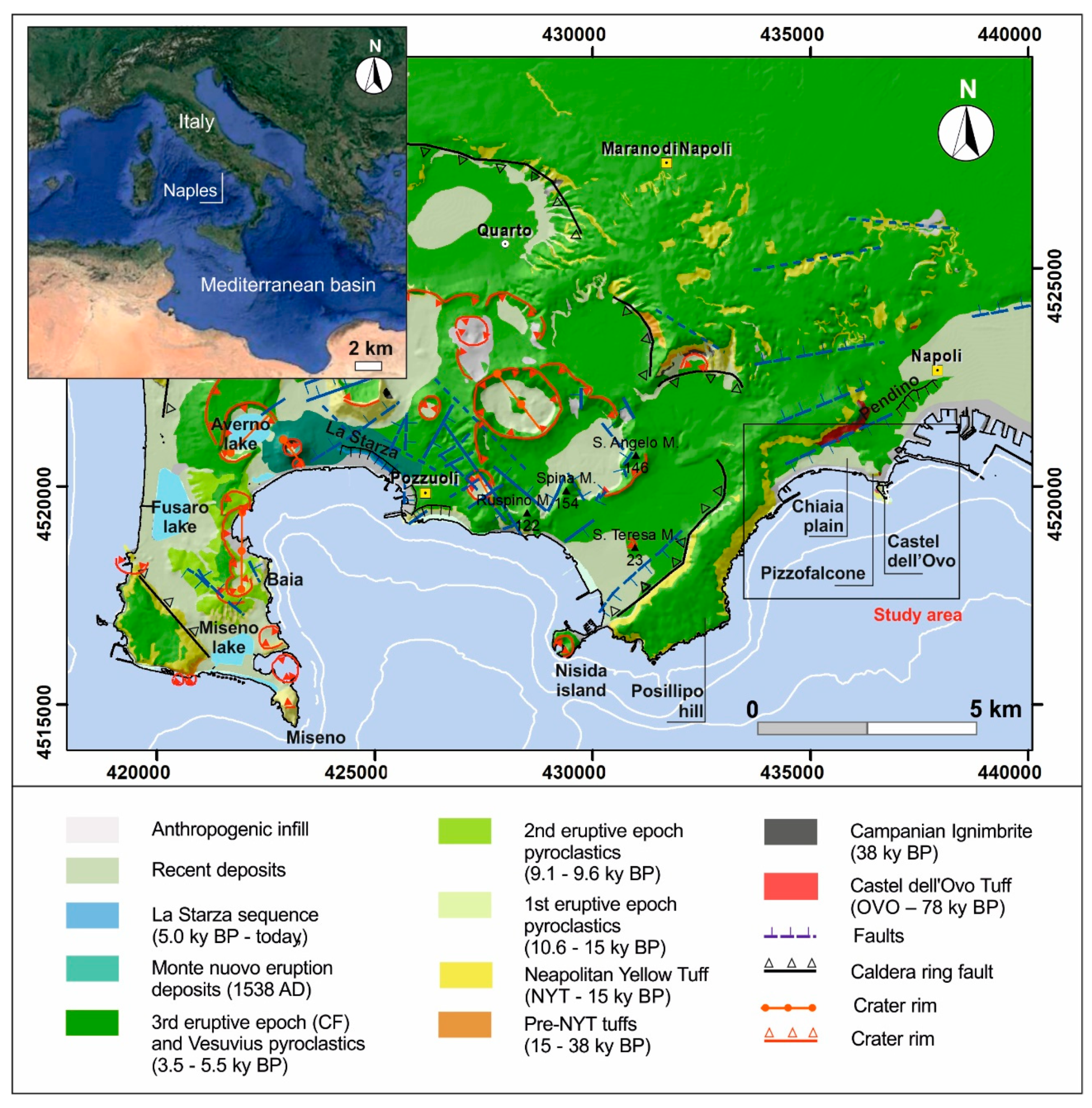
2. Geological and Geomorphological Background

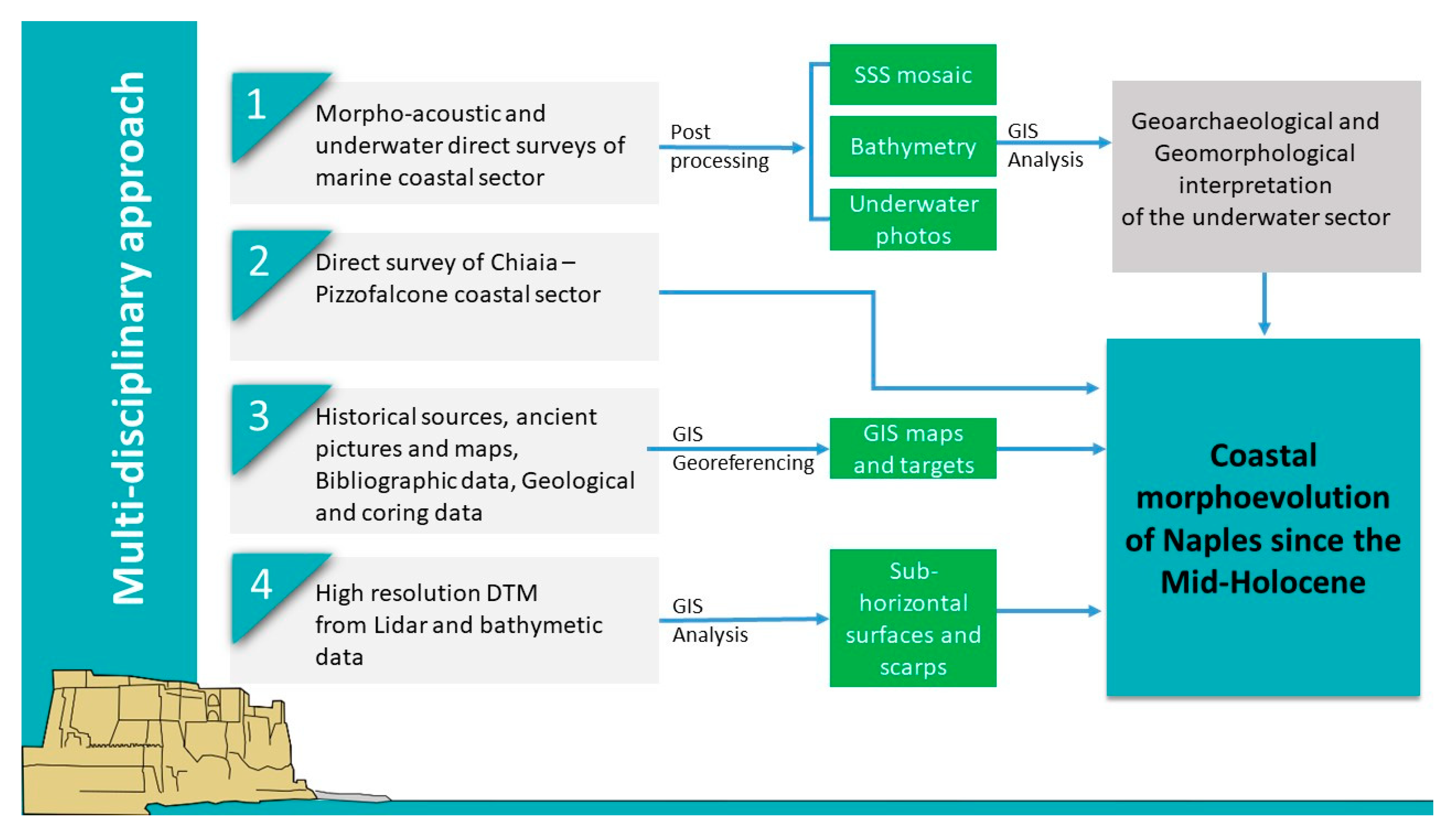
3. Materials and Methods
3.1. Data and Sources
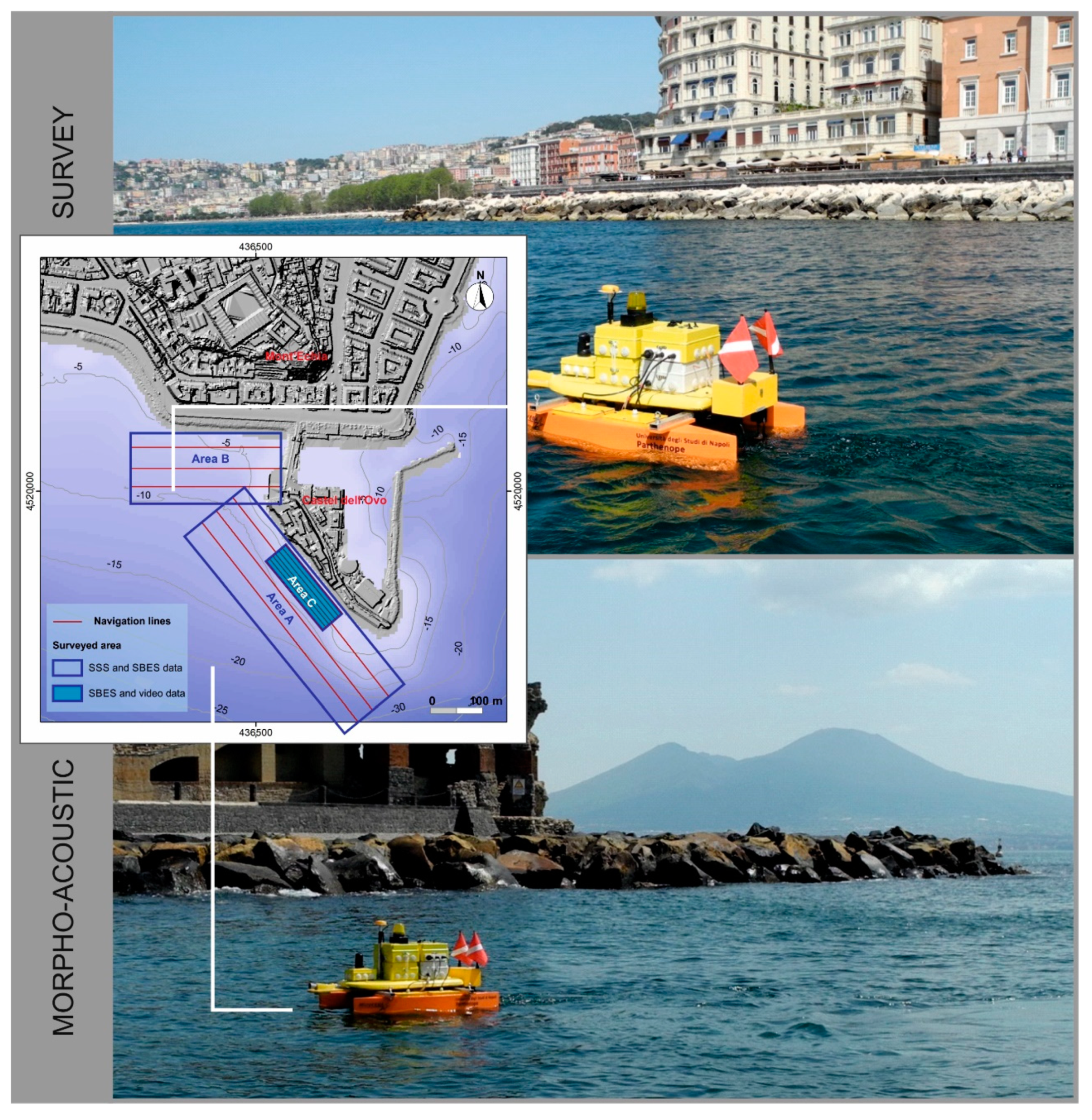
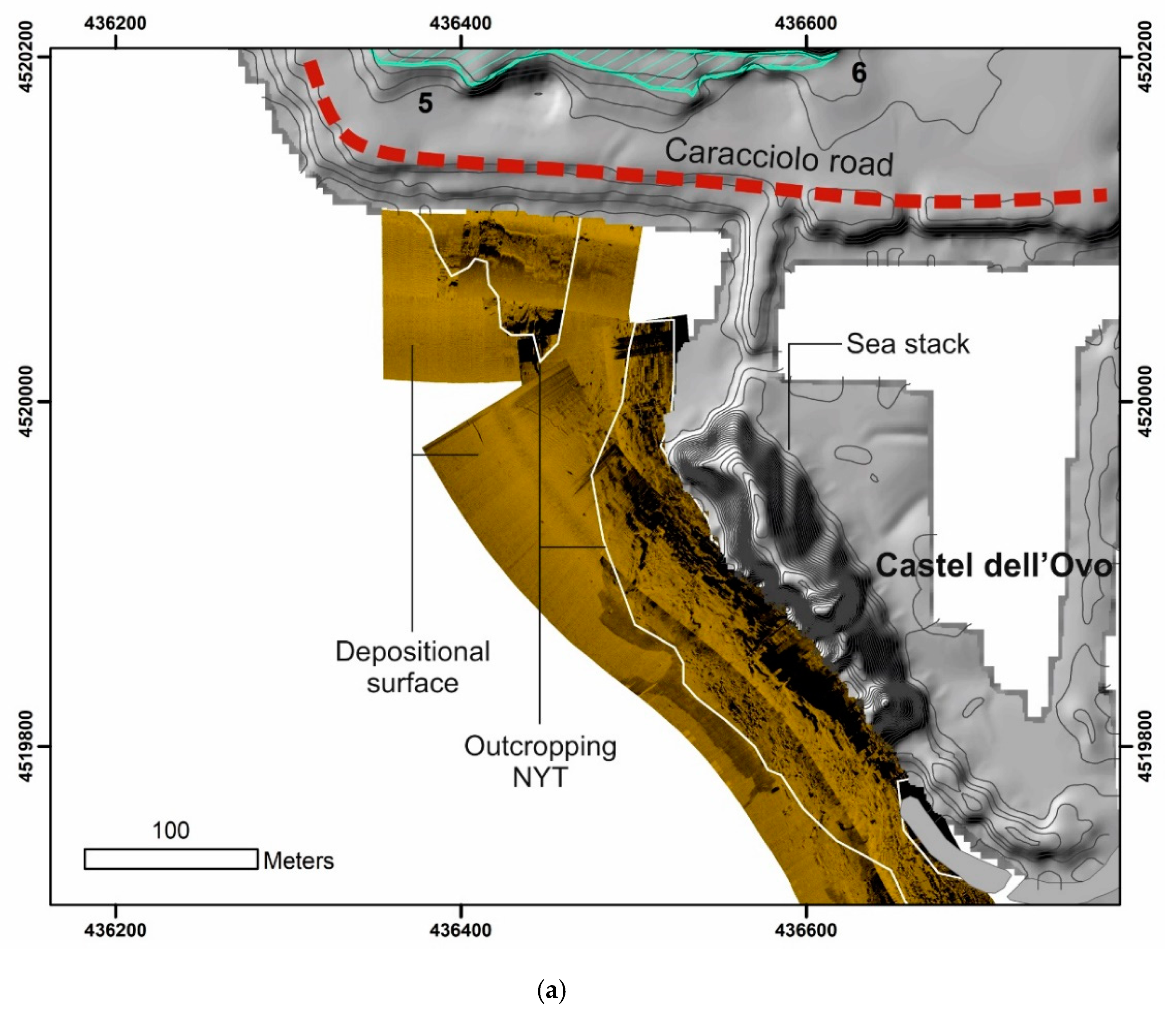
3.2. Morpho-Acoustic and Underwater Survey
3.3. Geomorphological and GIS Analysis
- morpho-structural analysis of the coastal sector by in situ surveys;
- morphometric analysis of extension, slope, and borders by spatial-analyzing the high-resolution DTMs;
- altimetric ordering and connectability between terrace relicts;
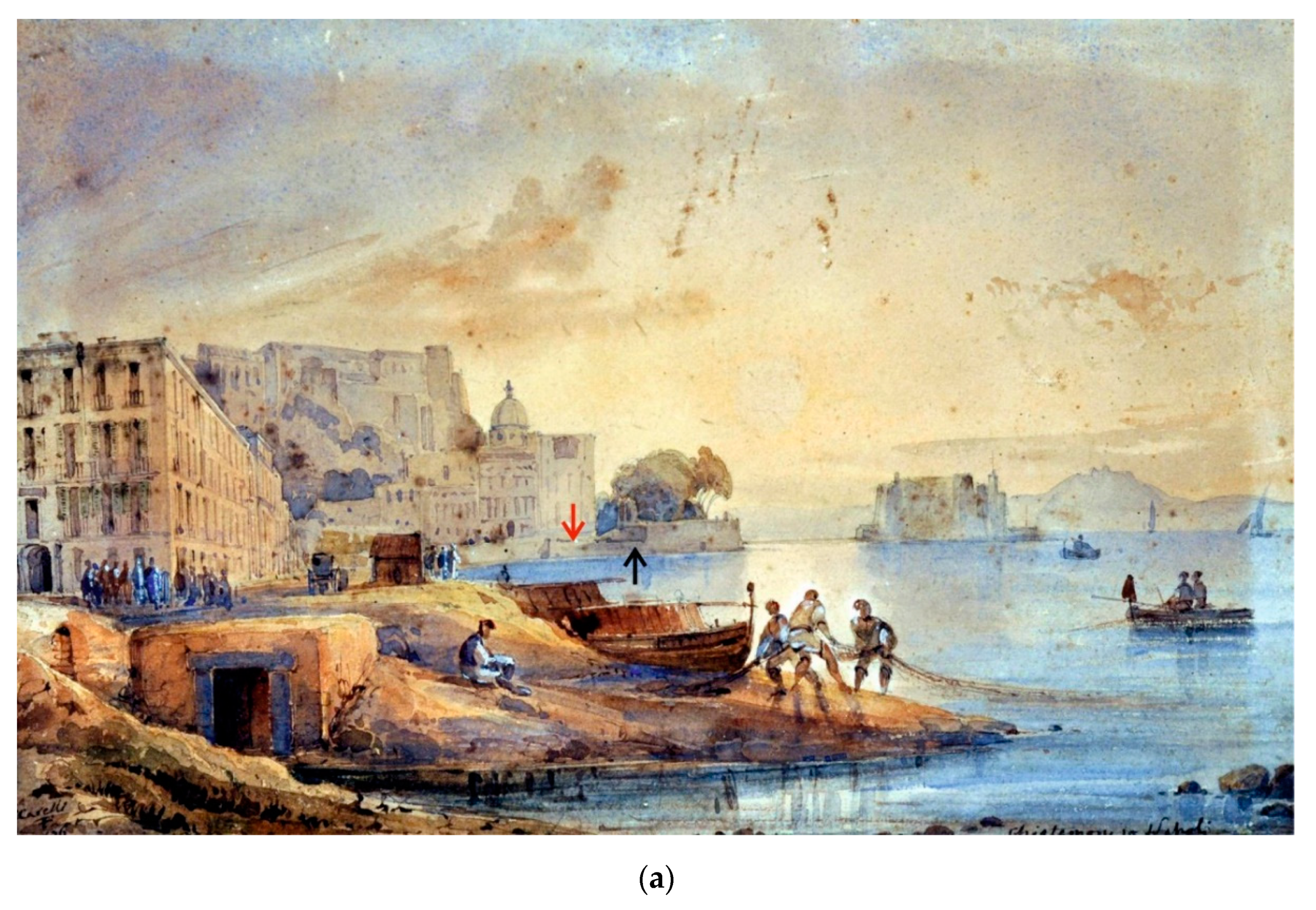
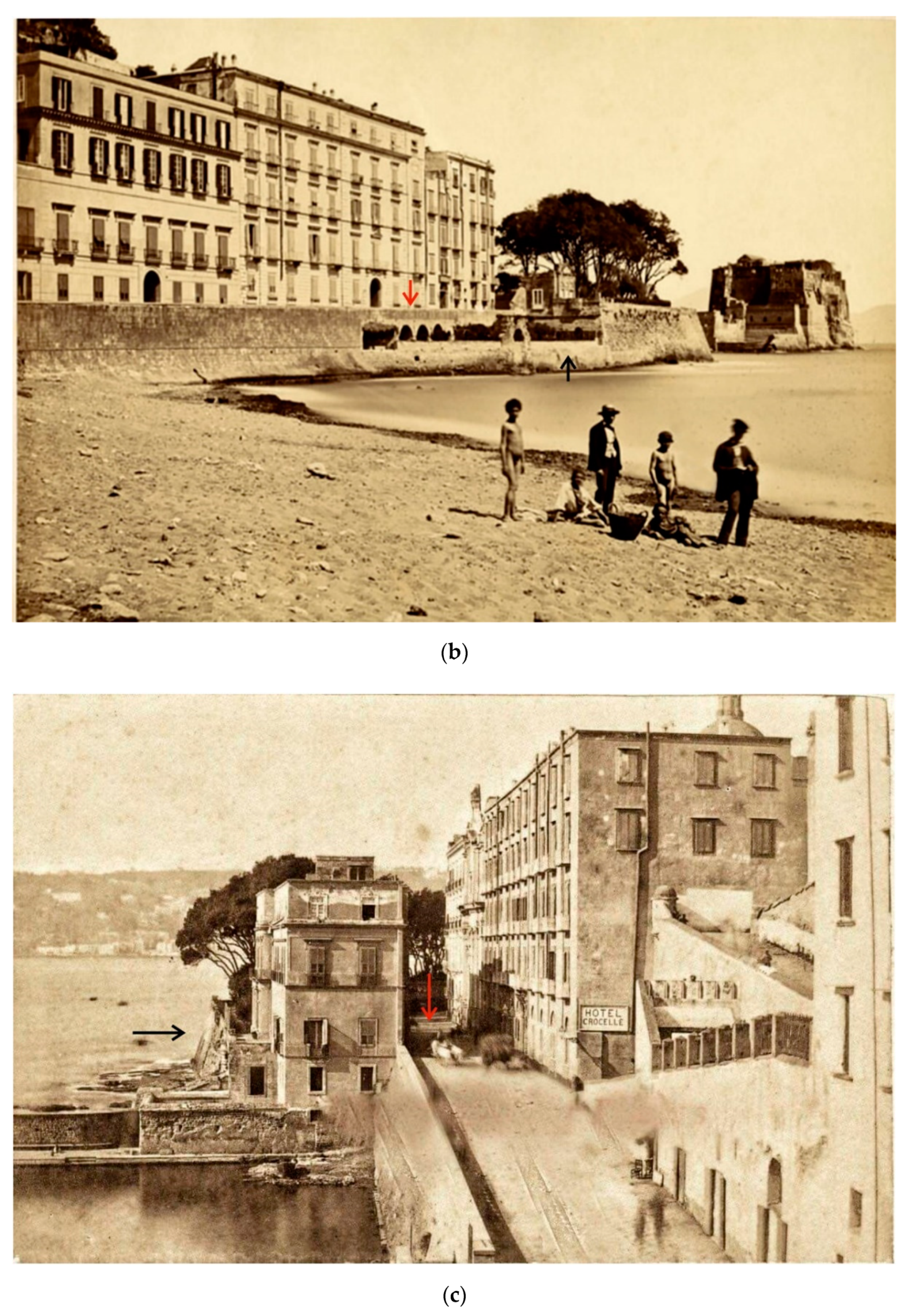
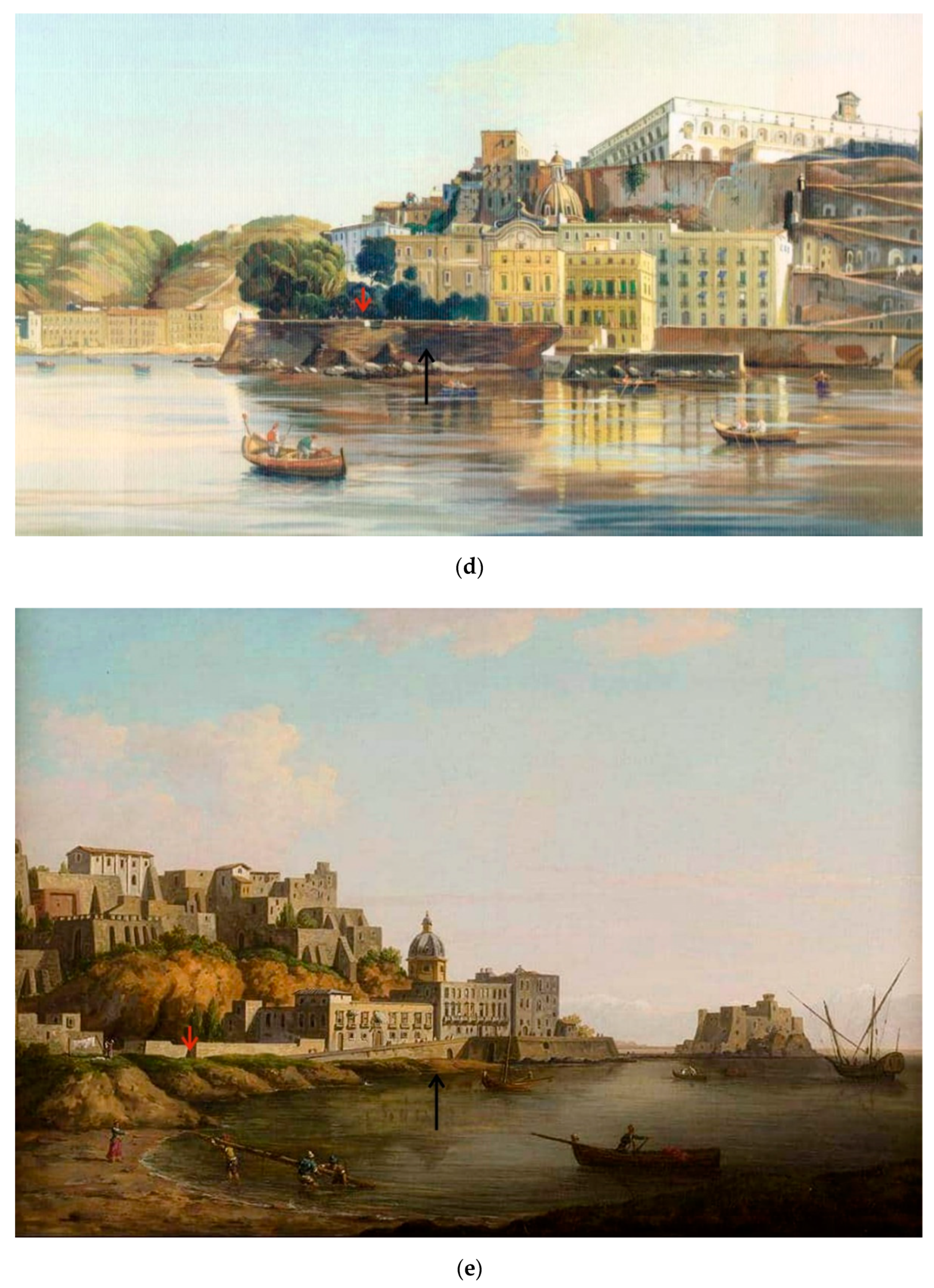
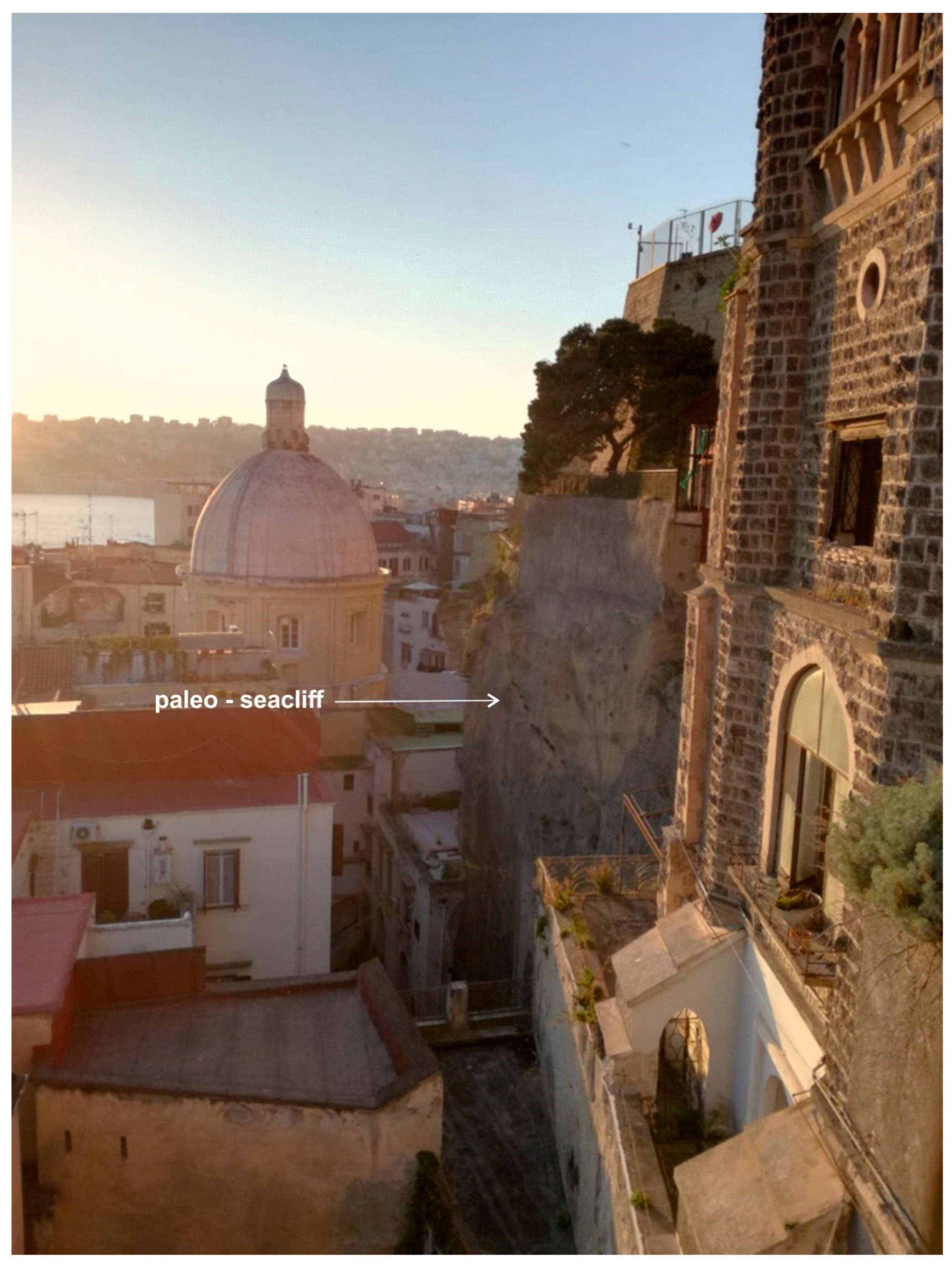
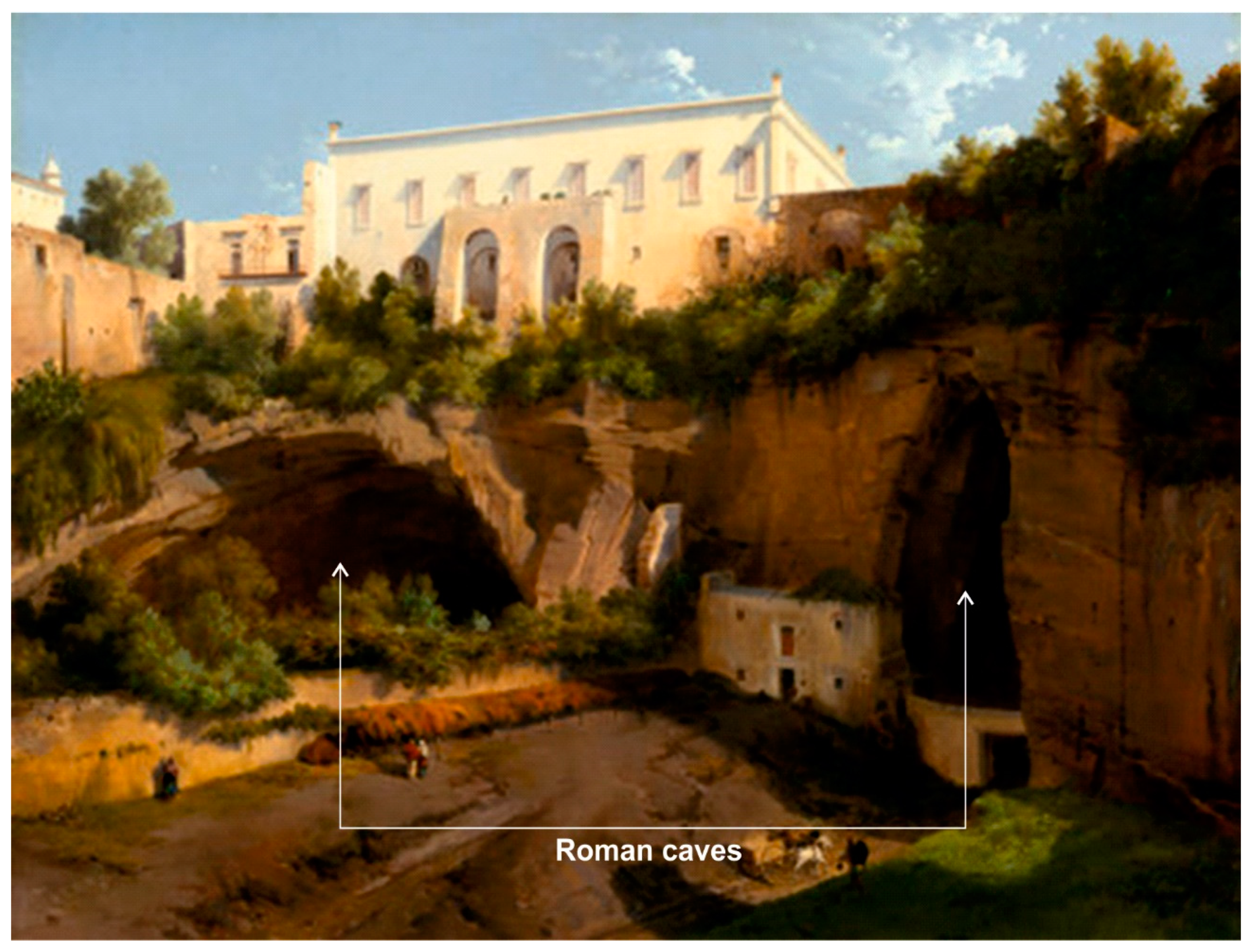
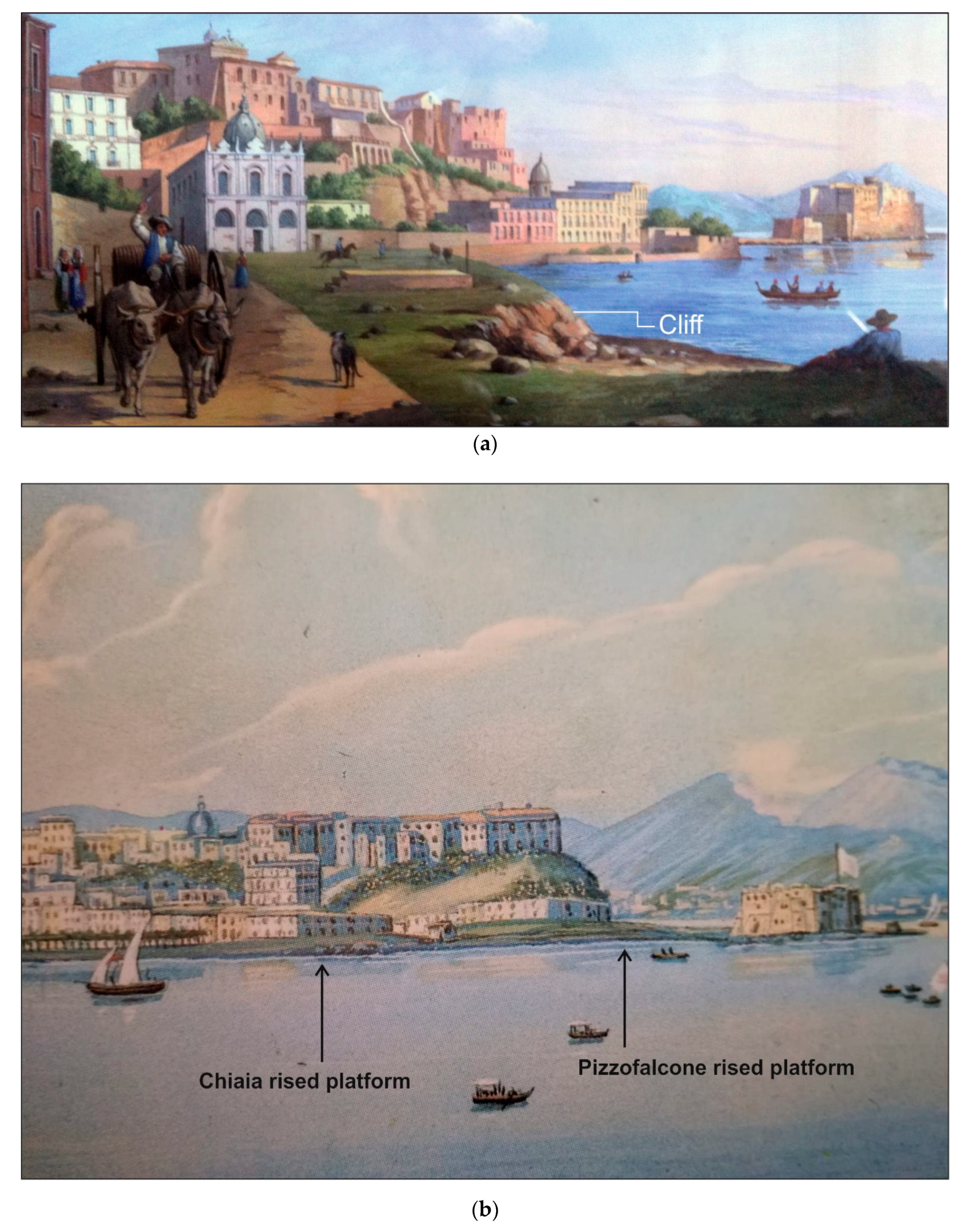
- analysis of historical sources, painting, and maps describing the landforms before the anthropic modifications; and,
- definition of the primary process forming the surface (erosion, deposition, etc.).
3.4. Shore Platforms as Sea-Level Indicators
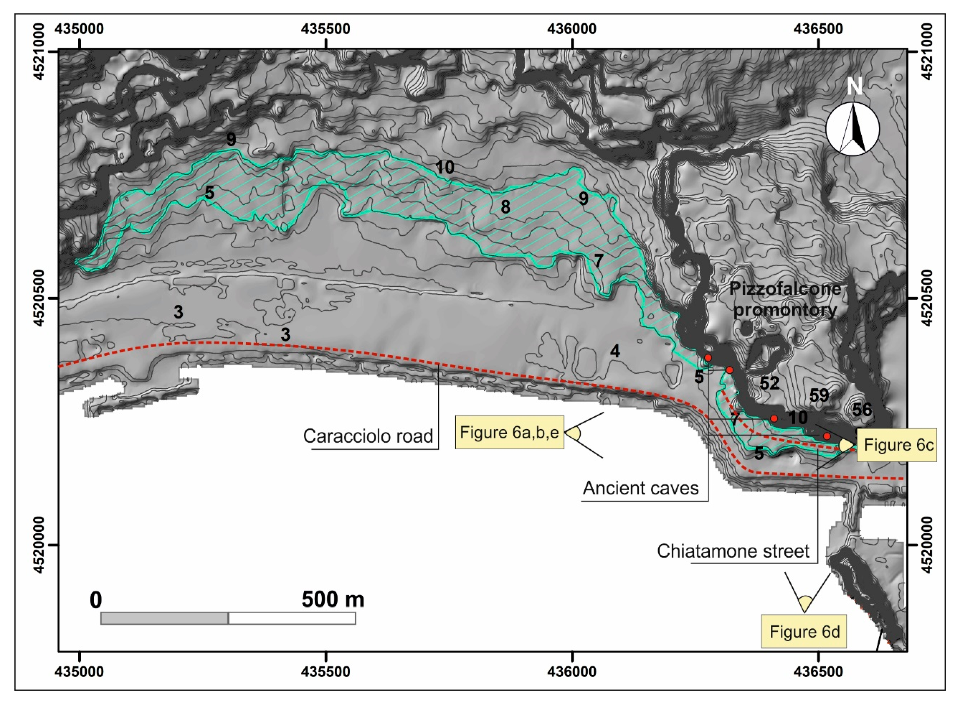
4. Results
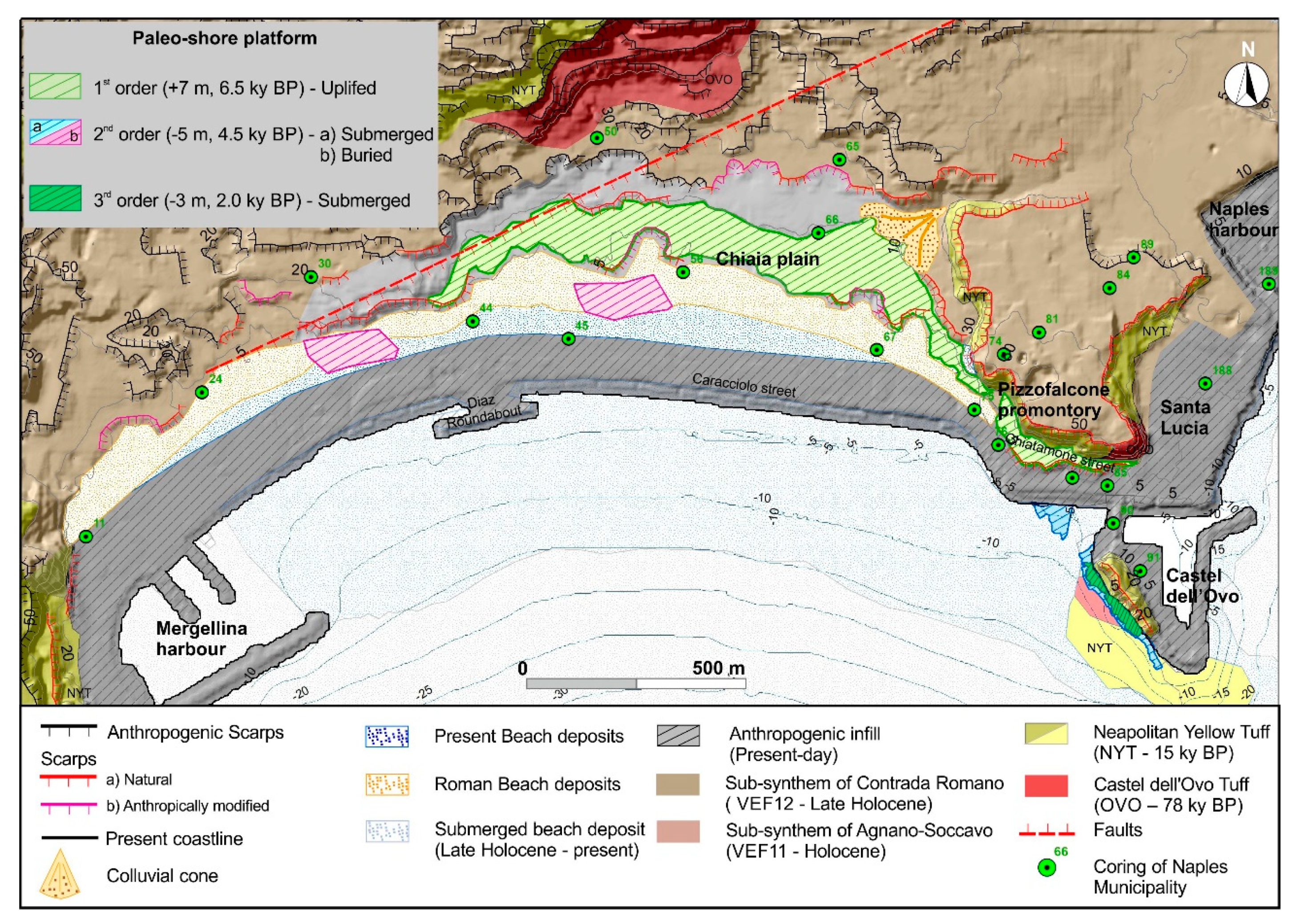
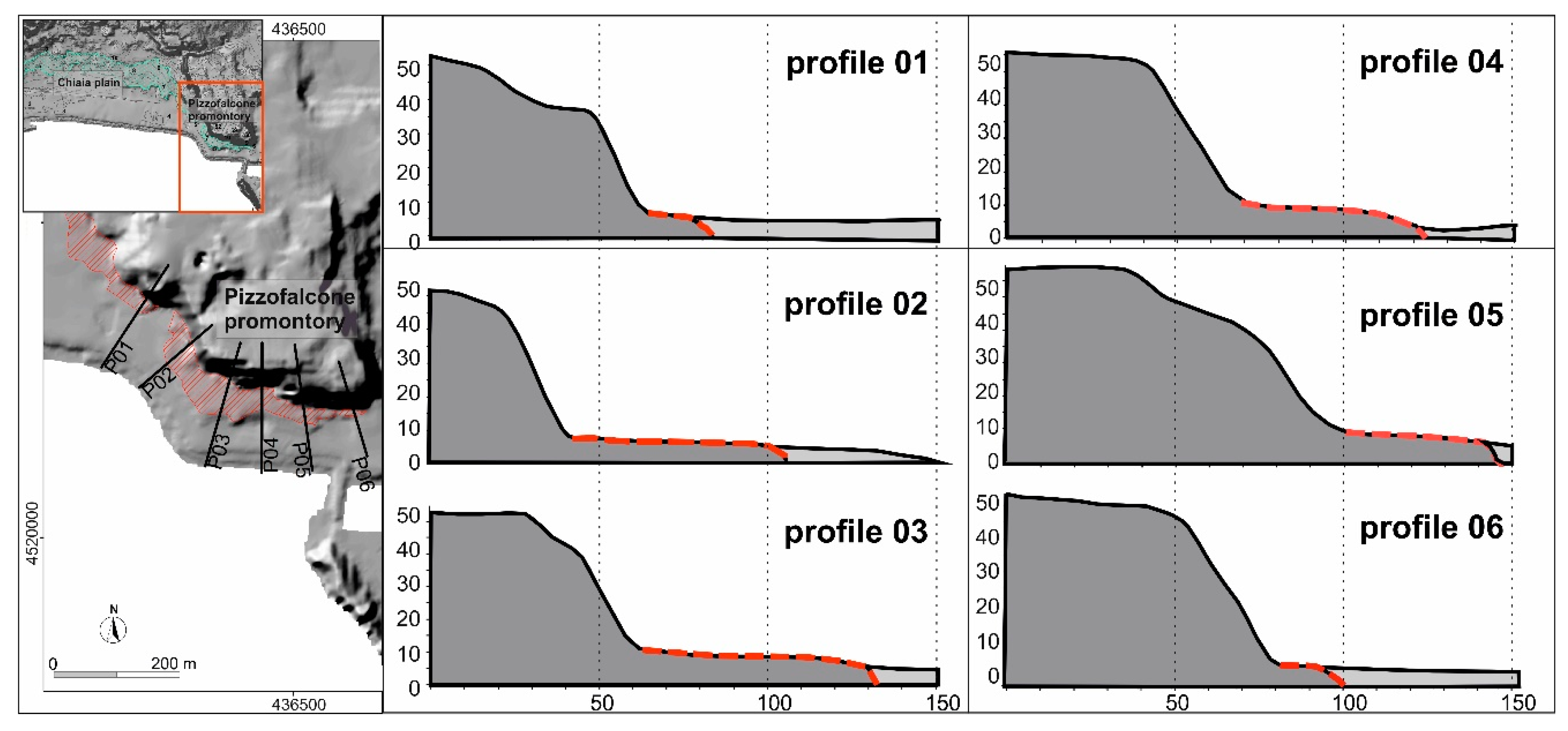
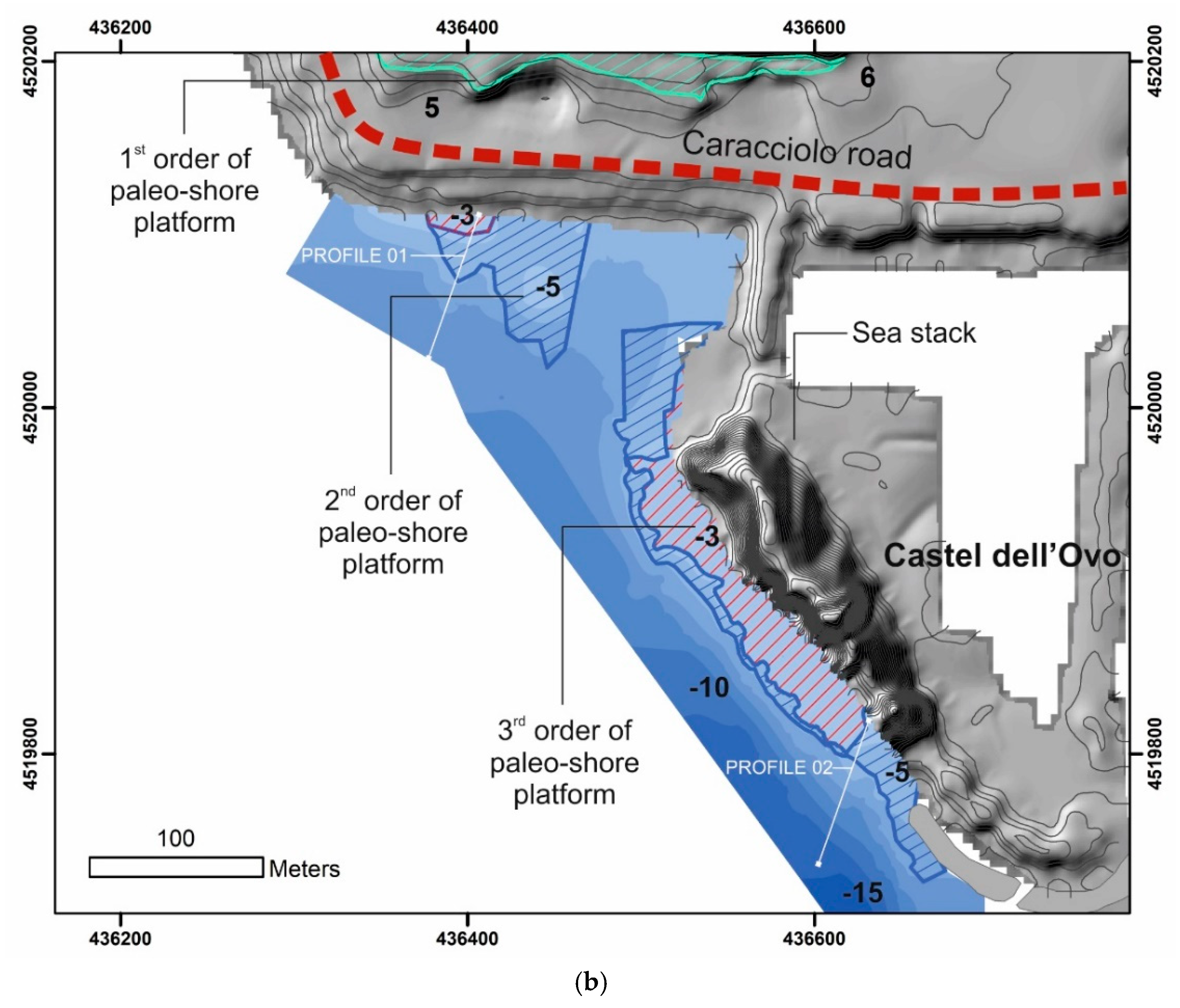
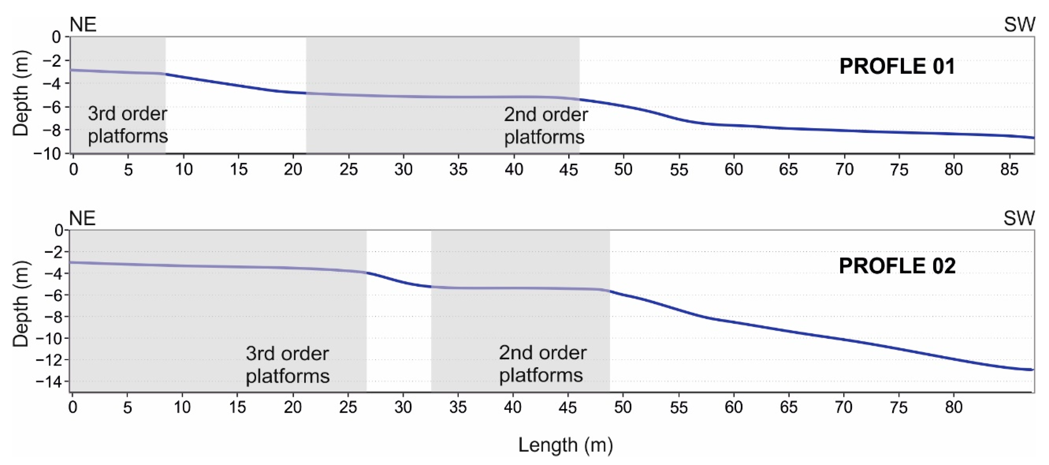
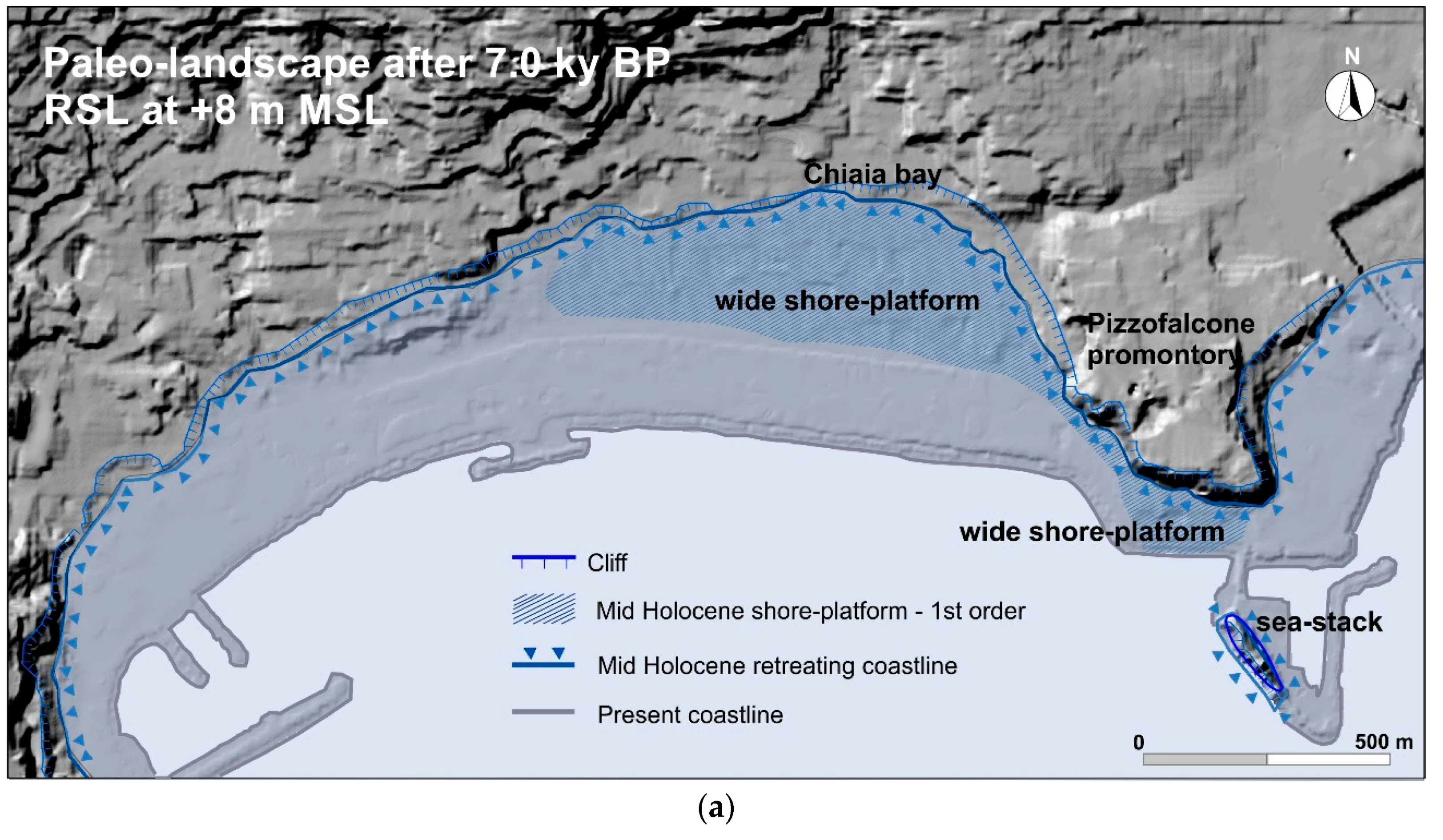
4.1. First-Order Paleo-Shore Platforms
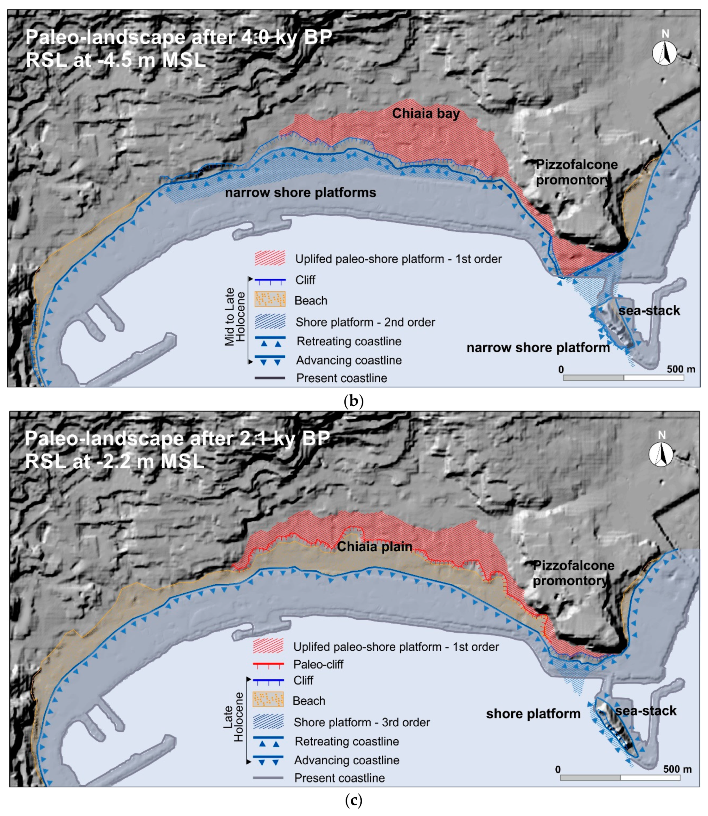
4.2. Second and Third Order Paleo-Shore Platforms
5. Discussion
6. Conclusions
- (T1)
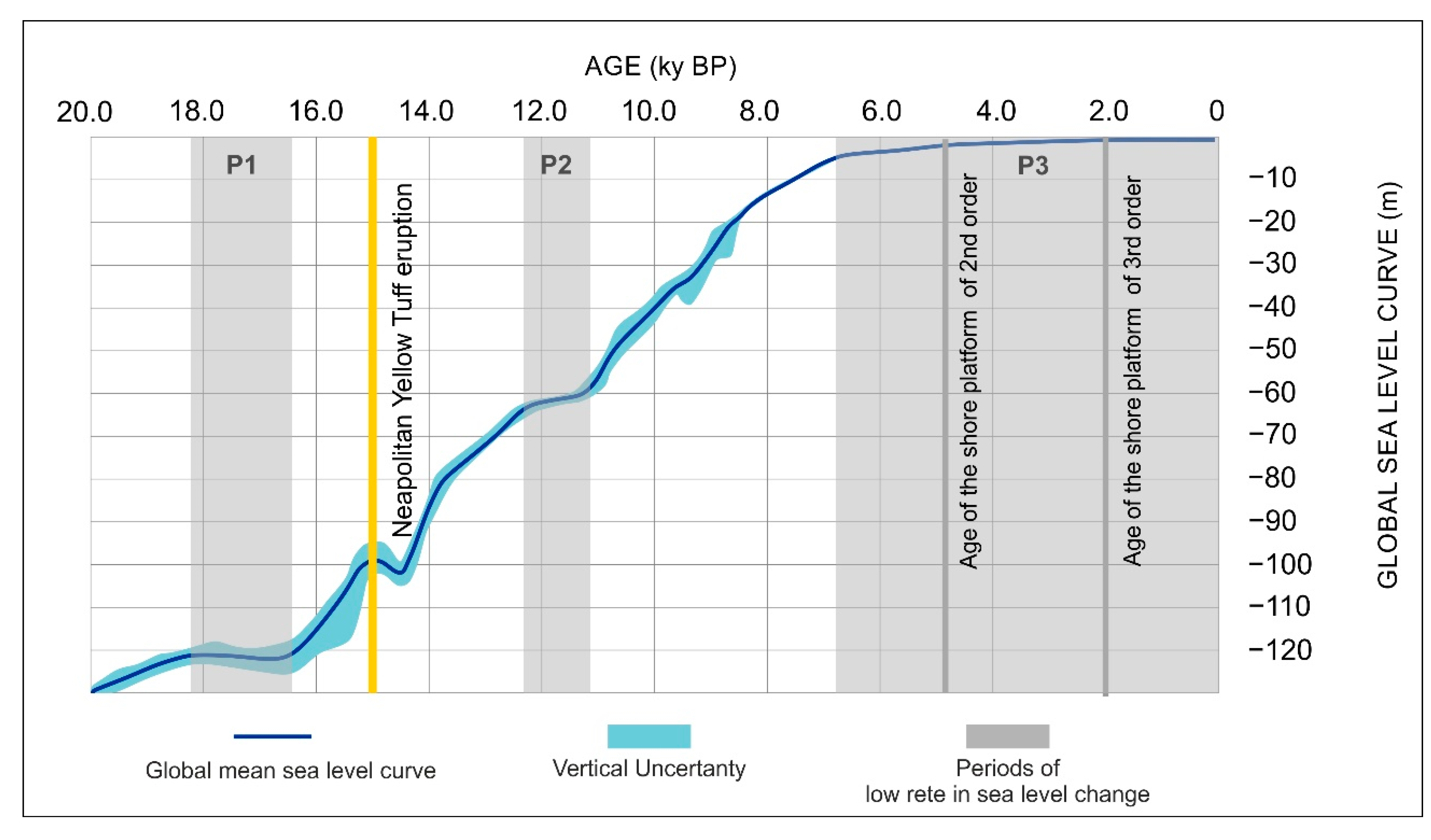
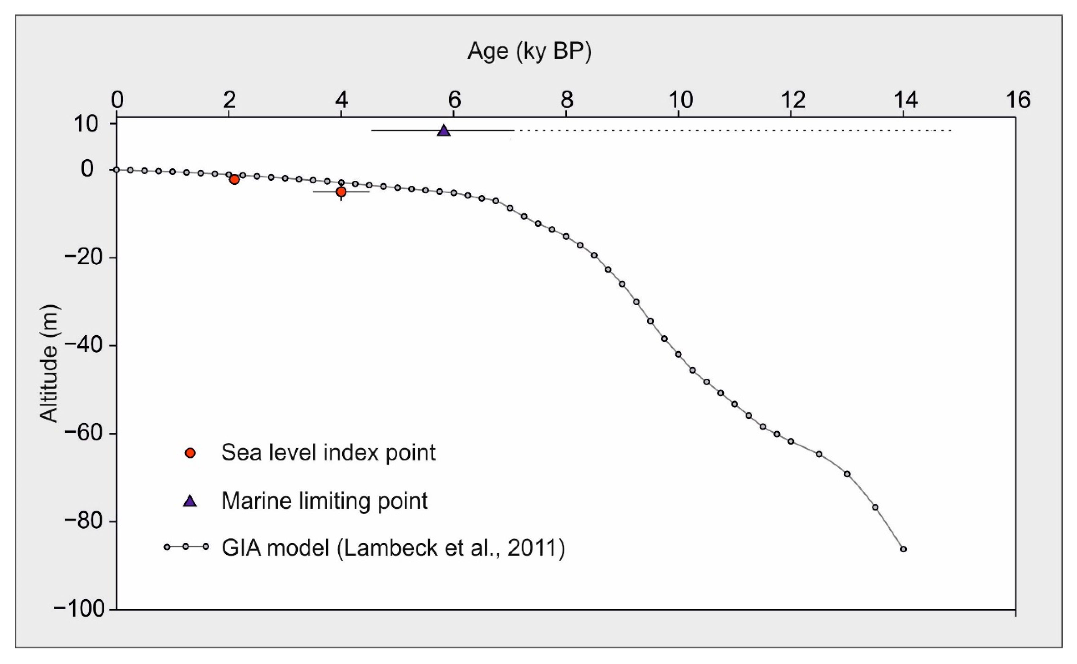
- period of substantial stability between 7.0 and 5.0 ky BP during which the first order platforms formed;
- (T2)
- an uplift of 10 to 13 m occurred shortly before the formation of the second order platforms about 5.0 ky BP;
- (T3)
- short period of stability during which the second order platform was abraded; and,
- (T4)
- period of prevailing subsidence covering the last 4 ky, which accelerated before the second century BC, considering that the RSL changed from −4.5 to −2.2 m MSL. This trend totalled about 2 m of lowering and was interrupted by a brief pause during the second century BC, when the third order platform formed, and the fish tank of the maritime villa at Castel dell’ Ovo was constructed on it.
Author Contributions
Funding
Acknowledgments
Conflicts of Interest
References
- Pappone, G.; Aucelli, P.P.C.; Alberico, I.; Amato, V.; Antonioli, F.; Cesarano, M.; Di Paola, G.; Pelosi, N. Relative sea-level rise and marine erosion and inundation in the Sele river coastal plain (Southern Italy): Scenarios for the next century. Rend. Lincei 2012, 23, 121–129. [Google Scholar] [CrossRef]
- Rovere, A.; Stocchi, P.; Vacchi, M. Eustatic and relative sea level changes. Curr. Clim. Chang. Rep. 2016, 2, 221–231. [Google Scholar]
- Stocchi, P.; Vacchi, M.; Lorscheid, T.; de Boer, B.; Simms, A.R.; van de Wal, R.S.W.; Vermeersen, B.L.A.; Pappalardo, M.; Rovere, A. MIS 5e relative sea-level changes in the Mediterranean Sea: Contribution of isostatic disequilibrium. Quat. Sci. Rev. 2018, 185, 122–134. [Google Scholar] [CrossRef] [Green Version]
- Khan, N.S.; Horton, B.P.; Engelhart, S.; Rovere, A.; Vacchi, M.; Ashe, E.L.; Törnqvist, T.E.; Dutton, A.; Hijma, M.P.; Shennan, I. Inception of a global atlas of sea levels since the Last Glacial Maximum. Quat. Sci. Rev. 2019, 220, 359–371. [Google Scholar] [CrossRef]
- Mann, T.; Bender, M.; Lorscheid, T.; Stocchi, P.; Vacchi, M.; Switzer, A.; Rovere, A. Relative sea-level data from the SEAMIS database compared to ICE-5G model predictions of glacial isostatic adjustment. Data Brief 2019, 27, 104600. [Google Scholar] [CrossRef]
- Prampolini, M.; Savini, A.; Foglini, F.; Soldati, M. Seven Good Reasons for Integrating Terrestrial and Marine Spatial Datasets in Changing Environments. Water 2020, 12, 2221. [Google Scholar] [CrossRef]
- Casella, E.; Drechsel, J.; Winter, C.; Benninghoff, M.; Rovere, A. Accuracy of sand beach topography surveying by drones and photogrammetry. Geo-Mar. Lett. 2020, 40, 1–14. [Google Scholar] [CrossRef] [Green Version]
- Fuhrmann, T.; Garthwaite, M.C. Resolving three-dimensional surface motion with InSAR: Constraints from multi-geometry data fusion. Remote Sens. 2019, 11, 241. [Google Scholar] [CrossRef] [Green Version]
- Di Paola, G.; Alberico, I.; Aucelli, P.P.C.; Matano, F.; Rizzo, A.; Vilardo, G. Coastal subsidence detected by Synthetic Aperture Radar interferometry and its effects coupled with future sea-level rise: The case of the Sele Plain (Southern Italy). J. Flood Risk Manag. 2018, 11, 191–206. [Google Scholar] [CrossRef] [Green Version]
- Vacchi, M.; Marriner, N.; Morhange, C.; Spada, G.; Fontana, A.; Rovere, A. Multiproxy assessment of. Holocene relative sea-level changes in the western Mediterranean: Sea-level variability and improvements. in the definition of the isostatic signal. Earth Sci. Rev. 2016, 155, 172–197. [Google Scholar] [CrossRef] [Green Version]
- Vacchi, M.; Ghilardi, M.; Melis, R.T.; Spada, G.; Giaime, M.; Marriner, N.; Lorscheid, T.; Morhange, C.; Burjachs, F.; Rovere, A. New relative sea-level insights into the isostatic history of the Western. Mediterranean. Quat. Sci. Rev. 2018, 201, 396–408. [Google Scholar] [CrossRef]
- Benjamin, J.; Rovere, A.; Fontana, A.; Furlani, S.; Vacchi, M.; Inglis, R.H.; Galili, E.; Antonioli, F.; Sivan, D.; Miko, S.; et al. Late Quaternary sea-level changes and early human societies in the central and eastern, Mediterranean Basin: An interdisciplinary review. Quat. Int. 2017, 449, 29–57. [Google Scholar] [CrossRef] [Green Version]
- Vecchio, A.; Anzidei, M.; Serpelloni, E.; Florindo, F. Natural Variability and Vertical Land Motion Contributions in the Mediterranean Sea-Level Records over the Last Two Centuries and Projections for 2100. Water 2019, 11, 1480. [Google Scholar] [CrossRef] [Green Version]
- Aucelli, P.; Cinque, A.; Mattei, G.; Pappone, G. Historical sea level changes and effects on the coasts of.Sorrento Peninsula (Gulf of Naples): New constrains from recent geoarchaeological investigations. Palaeogeogr. Palaeoclim. Palaeoecol. 2016, 463, 112–125. [Google Scholar] [CrossRef]
- Amato, V.; Aucelli, P.P.C.; Mattei, G.; Pennetta, M.; Rizzo, A.; Rosskopf, C.M.; Schiattarella, M.A. Geodatabase of Late Pleistocene-Holocene palaeo sea-level markers in the Gulf of Naples. Alp. Mediterr. Quat. 2018, 31, 5–9. [Google Scholar]
- Lorscheid, T.; Stocchi, P.; Casella, E.; Gómez-Pujol, L.; Vacchi, M.; Mann, T.; Rovere, A. Paleo sea-level changes and relative sea-level indicators: Precise measurements, indicative meaning and glacial isostatic adjustment perspectives from Mallorca (Western Mediterranean). Palaeogeogr. Palaeoclim. Palaeoecol. 2017, 473, 94–107. [Google Scholar] [CrossRef]
- Peltier, W.R. Global glacial isostasy and the surface of the ice-age Earth: The ICE-5 G (VM2) model and GRACE. Annu. Rev. Earth Planet. Sci. 2004, 32, 111–149. [Google Scholar] [CrossRef]
- Spada, G.; Stocchi, P. SELEN: A Fortran 90 program for solving the “sea-level equation”. Comput. Geosci. 2007, 33, 538–562. [Google Scholar] [CrossRef]
- Lambeck, K.; Antonioli, F.; Anzidei, M.; Ferranti, L.; Leoni, G.; Scicchitano, G.; Silenzi, S. Sea level change along the Italian coasts during Holocene and prediction for the future. Quat. Int. 2011, 232, 250–257. [Google Scholar] [CrossRef]
- Vacchi, M.; Rovere, A.; Zouros, N.; Desruelles, S.; Caron, V.; Firpo, M. Spatial distribution of sea-level markers on Lesvos Island (NE Aegean Sea): Evidence of differential relative sea-level changes and the neotectonic implications. Geomorphology 2012, 159, 50–62. [Google Scholar] [CrossRef] [Green Version]
- Vacchi, M.; Ghilardi, M.; Spada, G.; Currás, A.; Robresco, S. New insights into the sea-level evolution in Corsica (NW Mediterranean) since the late Neolithic. J. Archaeol. Sci. Rep. 2017, 12, 782–793. [Google Scholar] [CrossRef]
- Carobene, L. Marine Notches and Sea-Cave Bioerosional Grooves in Microtidal Areas: Examples from the Tyrrhenian and Ligurian Coasts-Italy. J. Coast Res. 2015, 31, 536–556. [Google Scholar] [CrossRef]
- Anzidei, M.; Lambeck, K.; Antonioli, F.; Furlani, S.; Mastronuzzi, G.; Serpelloni, E.; Vannucci, G. Coastal structure, sea-level changes and vertical motion of the land in the Mediterranean. In Sedimentary Coastal Zones from High to Low Latitudes: Similarities and Differences Special Publications 388; Martini, I.P., Ed.; The Geological Society: London, UK, 2014. [Google Scholar] [CrossRef]
- Shennan, I. Handbook of sea-level research: Framing research questions. In Handbook of Sea-Level Research; Shennan, I., Long, A.J., Horton, B.P., Eds.; John Wiley & Sons: Oxford, UK, 2015; pp. 3–25. [Google Scholar]
- Rovere, A.; Raymo, M.E.; Vacchi, M.; Lorscheid, T.; Stocchi, P.; Gómez-Pujol, L.; Harris, D.L.; Casella, E.; O’Leary, M.J.; Hearty, P.J. The analysis of Last Interglacial (MIS 5e) relative sea-level indicators: Reconstructing sea-level in a warmer world. Earth-Sci. Rev. 2016, 159, 404–427. [Google Scholar] [CrossRef] [Green Version]
- Amato, V.; Aucelli, P.P.C.; Cinque, A.; D’Argenio, B.; Di Donato, V.; Pappone, G.; Petrosino, P.; Rosskopf, C.M.; Russo Ermolli, E. Holocene palaeo-geographical evolution of the Sele river coastal plain (Southern Italy): New morpho-sedimentary data from the Paestum area. Il Quat. 2011, 24, 5–7. [Google Scholar]
- Pappone, G.; Alberico, I.; Amato, V.; Aucelli, P.P.C.; Di Paola, G. Recent evolution and the present-day conditions of the Campanian Coastal plains (South Italy): The case history of the Sele River Coastal plain. WIT Trans. Ecol. Env. 2011, 149, 15–27. [Google Scholar]
- Alberico, I.; Amato, V.; Aucelli, P.P.C.; Di Paola, G.; Pappone, G.; Rosskopf, C.M. Historical and recent changes of the Sele River coastal plain (Southern Italy): Natural variations and human pressures. Rend. Lincei 2012, 23, 3–12. [Google Scholar] [CrossRef]
- Vacchi, M.; Rovere, A.; Chatzipetros, A.; Zouros, N.; Firpo, M. An updated database of Holocene relative sea level changes in NE Aegean Sea. Quat. Int. 2014, 328, 301–310. [Google Scholar] [CrossRef]
- Engelhart, S.E.; Vacchi, M.; Horton, B.P.; Nelson, A.R.; Kopp, R.E. A sea-level database for the Pacific coast of central North America. Quat. Sci. Rev. 2015, 113, 78–92. [Google Scholar] [CrossRef]
- Seeliger, M.; Pint, A.; Frenzel, P.; Weisenseel, P.K.; Erkul, E.; Wilken, D.; Wunderlich, T.; Başaran, S.; Bücherl, H.; Herbrecht, M.; et al. Using a multi-proxy approach to detect and date a buried part of the Hellenistic City Wall of Ainos (NW Turkey). Geosciences 2018, 8, 357. [Google Scholar] [CrossRef] [Green Version]
- Ronchi, L.; Fontana, A.; Correggiari, A.; Remia, A. Anatomy of a transgressive tidal inlet reconstructed through high-resolution seismic profiling. Geomorphology 2019, 343, 65–80. [Google Scholar] [CrossRef]
- Cinque, A.; De Pippo, T.; Romano, P. Coastal slope terracing and relative sea-level changes: Deductions based on computer simulations. Earth Surf. Proc. Land. 1995, 20, 87–103. [Google Scholar] [CrossRef]
- Kanyaya, J.I.; Trenhaile, A.S. Tidal wetting and drying on shore platforms: An experimental assessment. Geomorphology 2005, 70, 129–146. [Google Scholar] [CrossRef]
- Ascione, A.; Aucelli, P.P.C.; Cinque, A.; Di Paola, G.; Mattei, G.; Ruello, M.; Russo Ermolli, E.; Santangelo, N.; Valente, E. Geomorphology of Naples and the Campi Flegrei: Human and natural landscapes in a restless land. J. Maps 2020, 1–11. [Google Scholar] [CrossRef]
- Cinque, A.; Irollo, G.; Romano, P.; Ruello, M.R.; Amato, L.; Giampaola, D. Ground movements and sea level changes in urban areas: 5000 years of geological and archaeological record from Naples (Southern Italy). Quat. Int. 2011, 232, 45–55. [Google Scholar] [CrossRef]
- Romano, P.; Di Vito, M.A.; Giampaola, D.; Cinque, A.; Bartoli, C.; Boenzi, G.; Detta, F.; Di Marco, M.; Giglio, M.; Iodice, S.; et al. Intersection of exogenous, endogenous and anthropogenic factors in the Holocene landscape: A study of the Naples coastline during the last 6000 years. Quat. Int. 2013, 303, 107–119. [Google Scholar] [CrossRef]
- Russo Ermolli, E.; Romano, P.; Ruello, M.R.; Lumaga, M.R.B. The natural and cultural landscape of Naples (southern Italy) during the Graeco-Roman and Late Antique periods. J. Archaeol. Sci. 2014, 42, 399–411. [Google Scholar] [CrossRef]
- Di Donato, V.; Ruello, M.R.; Liuzza, V.; Carsana, V.; Giampaola, D.; Di Vito, M.A.; Morhange, C.; Cinque, A.; Russo Ermolli, E. Development and decline of the ancient harbor of Neapolis. Geoarcheaology 2018, 33, 542–557. [Google Scholar] [CrossRef]
- Vacchi, M.; Russo Ermolli, E.; Morhange, C.; Ruello, M.; Di Donato, V.; Di Vito, M.; Giampaola, D.; Carsana, V.; Liuzza, V.; Cinque, A.; et al. Millennial variability of rates of sea-level rise in the ancient harbour of Naples (Italy, western Mediterranean Sea). Quat. Res. 2019, 93, 284–298. [Google Scholar] [CrossRef]
- Delile, H.; Goiran, J.P.; Blichert-Toft, J.; Arnaud-Godet, F.; Romano, P.; Bravard, J.P. A geochemical and sedimentological perspective of the life cycle of Neapolis harbor (Naples, southern Italy). Quat. Sci. Rev. 2016, 150, 84–97. [Google Scholar] [CrossRef]
- Aucelli, P.P.C.; Cinque, A.; Mattei, G.; Pappone, G. Late Holocene landscape evolution of the gulf of Naples (Italy) inferred from geoarchaeological data. J. Maps 2017, 13, 300–310. [Google Scholar] [CrossRef] [Green Version]
- Aucelli, P.P.C.; Cinque, A.; Mattei, G.; Pappone, G.; Stefanile, M. Coastal landscape evolution of Naples (Southern Italy) since the Roman period from archaeological and geomorphological data at Palazzo degli Spiriti site. Quat. Int. 2018, 483, 23–38. [Google Scholar] [CrossRef]
- Aucelli, P.P.C.; Cinque, A.; Mattei, G.; Pappone, G.; Rizzo, A. Studying relative sea level change and correlative adaptation of coastal structures on submerged Roman time ruins nearby Naples (southern Italy). Quat. Int. 2019, 501, 328–348. [Google Scholar] [CrossRef]
- Pappone, G.; Aucelli, P.P.C.; Mattei, G.; Peluso, F.; Stefanile, M.; Carola, A. A Detailed Reconstruction of the Roman Landscape and the Submerged Archaeological Structure at “Castel dell’Ovo islet” (Naples, Southern Italy). Geosciences 2019, 9, 170. [Google Scholar] [CrossRef] [Green Version]
- Carsana, V.; Febbraro, S.; Giampaola, D.; Guastaferro, C.; Irollo, G.; Ruello, M.R. Evoluzione del paesaggio costiero tra Parthenopee Neapolis. Méditerranée Revue Géographique Pays Méditerranéens J. Mediterr. Geogr. 2009, 112, 14–22. [Google Scholar] [CrossRef]
- Aucelli, P.P.C.; Cinque, A.; Mattei, G.; Pappone, G.; Stefanile, M. First results on the coastal changes related to local sea level variations along the Puteoli sector (Campi Flegrei, Italy) during the historical times. Alp. Mediterr. Quat. 2018, 31, 13–16. [Google Scholar]
- Pappalardo, U.; Russo, F. Il Bradisismo dei Campi Flegrei (Campania): Dati Geomorfologici ed Evidenze. Archeologiche. In Forma Maris, Atti Della Rassegna Internazionale di Archeologia Subacquea (Pozzuoli 1998); Gianfrotta, P.A., Maniscalco, F., Eds.; Massa Editore: Pozzuoli, Italy, 2001. [Google Scholar]
- Morhange, C.; Marriner, N.; Laborel, J.; Todesco, M.; Oberlin, C. Rapid sea-level movements and noneruptive crustal deformation in the phlegrean Fields caldera, Italy. Geology 2006, 34, 93–96. [Google Scholar] [CrossRef]
- Bellucci, F.; Woo, J.; Kilburn, C.R.; Rolandi, G. Ground deformation at Campi Flegrei, Italy: Implications for hazard assessment. Geol. Soc. Lond. Spec. Publ. 2006, 269, 141–157. [Google Scholar] [CrossRef]
- Del Gaudio, C.; Aquino, I.; Ricciardi, G.P.; Ricco, C.; Scandone, R. Unrest episodes at Campi Flegrei: A reconstruction of vertical ground movements during 1905–2009. J. Volcanol. Geotherm. Res. 2010, 195, 48–56. [Google Scholar] [CrossRef]
- Passaro, S.; Barra, M.; Saggiomo, R.; Di Giacomo, S.; Leotta, A.; Uhlen, H.; Mazzola, S. Multi-resolution morphobathymetric survey results at the Pozzuoli-Baia underwater archaeological site (Naples, Italy). J. Archaeol. Sci. 2013, 40, 1268–1278. [Google Scholar] [CrossRef]
- Aucelli, P.P.C.; Mattei, G.; Caporizzo, C.; Cinque, A.; Troisi, S.; Peluso, F.; Stefanile, M.; Pappone, G. Ancient Coastal Changes Due to Ground Movements and Human Interventions in the Roman Portus Julius (Pozzuoli Gulf, Italy): Results from Photogrammetric and Direct Surveys. Water 2020, 12, 658. [Google Scholar] [CrossRef] [Green Version]
- Stefanile, M.; Mattei, G.; Troisi, S.; Aucelli, P.P.C.; Pappone, G.; Peluso, F. The Pilae of Nisida. Some geological and archaeological observations. Archaeol. Marit. Mediterr. Int. J. Underw. Archaeol. 2018, 15, 81–100. [Google Scholar]
- Giaccio, B.; Isaia, R.; Fedele, F.; Di Canzio, E.; Hoffecker, J.; Ronchitelli, A.; Sinitsyn, A.; Anikovich, M.; Lisitsyn, S.; Popov, V.V. The Campanian Ignimbrite and Codola tephra layers: Two temporal/stratigraphic markers for the Early Upper Palaeolithic in southern Italy and eastern Europe. J. Volcanol. Geoth. Res. 2008, 177, 208–226. [Google Scholar] [CrossRef] [Green Version]
- Costa, A.; Folch, A.; Macedonio, G.; Giaccio, B.; Isaia, R.; Smith, V. Quantifying volcanic ash dispersal and impact of the Campanian Ignimbrite super-eruption. Geophys. Res. 2012, 39, L10310. [Google Scholar] [CrossRef] [Green Version]
- Albert, P.G.; Giaccio, B.; Isaia, R.; Costa, A.; Niespolo, E.M.; Nomade, S.; Pereira, A.; Renne, P.R.; Hinchliffe, A.; Mark, D.F.; et al. Evidence for a large-magnitude eruption from Campi Flegrei caldera (Italy) at 29 ka. Geology 2019, 47, 595–599. [Google Scholar] [CrossRef] [Green Version]
- Deino, A.L.; Orsi, G.; Piochi, M.; de Vita, S. The age of the Neapolitan Yellow Tuff caldera-forming eruption (Campi Flegrei caldera-Italy) assessed by 40Ar/39Ar dating method. J. Volcanol. Geoth. Res. 2004, 185, 48–56. [Google Scholar] [CrossRef]
- Orsi, G.; D’Antonio, M.; de Vita, S.; Gallo, G. The Neapolitan Yellow Tuff, a large-magnitude trachytic phreatoplinian eruption: Eruptive dynamics, magma withdrawal and caldera collapse. J. Volcanol. Geotherm. Res. 1992, 53, 275–287. [Google Scholar] [CrossRef]
- Sacchi, M.; Pepe, F.; Corradino, M.; Insinga, D.D.; Molisso, F.; Lubritto, C. The Neapolitan Yellow Tuff caldera offshore the Campi Flegrei: Stratal architecture and kinematic reconstruction during the last 15 ky. Mar. Geol. 2014, 354, 15–33. [Google Scholar] [CrossRef] [Green Version]
- Smith, V.C.; Isaia, R.; Pearce, N.J.C. Tephrostratigraphy and glass compositions of post-15 kyr Campi. Flegrei eruptions: Implications for eruption history and chronostratigraphic markers. Quat. Sci. Rev. 2011, 30, 3638–3660. [Google Scholar] [CrossRef]
- Isaia, R.; Vitale, S.; Marturano, A.; Aiello, G.; Barra, D.; Ciarcia, S.; Iannuzzi, E.; Tramparulo, F. High-resolution geological investigations to reconstruct the long-term ground movements in the last 15 kyr at Campi Flegrei caldera (southern Italy). J. Volcanol. Geotherm. Res. 2019, 385, 143–158. [Google Scholar] [CrossRef]
- Dvorak, J.J.; Mastrolorenzo, G. The mechanisms of recent vertical crustal movements in Campi Flegrei caldera, southern Italy. Spec. Pap. Geol. Soc. Am. 1991, 263, 49. [Google Scholar]
- Todesco, M.; Costa, A.; Comastri, A.; Colleoni, F.; Spada, G.; Quareni, F. Vertical ground displacement at Campi Flegrei (Italy) in the fifth century: Rapid subsidence driven by pore pressure drop. Geophys. Res. Lett. 2014, 41, 1471–1478. [Google Scholar] [CrossRef] [Green Version]
- Di Vito, M.; Lirer, L.; Mastrolorenzo, G.; Rolandi, G. The 1538 Monte Nuovo eruption (Campi Flegrei, Italy). Bull. Volcanol. 1987, 49, 608–615. [Google Scholar] [CrossRef]
- D’Antonio, M.; Civetta, L.; Orsi, G.; Pappalardo, L.; Piochi, M.; Caradente, A.; de Vita, S.; Di Vito, M.A.; Isaia, R. The present state of the magmatic system of the Campi Flegrei caldera based on a reconstruction of its behavior in the past 12 Ka. J. Volcanol. Geotherm. Res. 1999, 2–4, 247–268. [Google Scholar] [CrossRef]
- Guidoboni, E.; Ciuccarelli, C. The Campi Flegrei caldera: Historical revision and new data on seismic crises, bradyseisms, the Monte Nuovo eruption and ensuing earthquakes (twelfth century 1582 AD). Bull. Volcanol. 2011, 73, 655–677. [Google Scholar] [CrossRef]
- Di Vito, A.; Acocella, V.; Aiello, G.; Barra, D.; Battaglia, M.; Carandente, A.; Del Gaudio, C.; de Vita, S.; Ricciardi, G.P.; Ricco, C.; et al. Magma transfer at Campi Flegrei caldera (Italy) before the 1538 AD eruption. Sci. Rep. 2016, 6, 32245. [Google Scholar] [CrossRef]
- Orsi, G.; Di Vito, M.A.; Isaia, R. Volcanic hazard assessment at the restless Campi Flegrei caldera. Bull. Volcanol. 2004, 66, 514–530. [Google Scholar] [CrossRef]
- Aucelli, P.; Brancaccio, L.; Cinque, A. Vesuvius and Campi Flegrei volcanoes. Activity, landforms and impact on settlements. In Landscapes and Landforms of Italy; Soldati, M., Marchetti, M., Eds.; Springer International Publishing: Cham, Switzerland, 2017; pp. 389–398. [Google Scholar] [CrossRef]
- Isaia, R.; Iannuzzi, E.; Sbrana, A.; Marianelli, P. Note Illustrative Della Carta Geologica d’Italia Alla Scala 1: 50.000. 2016; Foglio 446-447 Napoli (aree emerse). Available online: https://www.isprambiente.gov.it/Media/carg/note_illustrative/446_447_Napoli.pdf (accessed on 18 September 2020).
- Giordano, F.; Mattei, G.; Parente, C.; Peluso, F.; Santamaria, R. MicroVeGA (micro vessel for geodetics application): A marine drone for the acquisition of bathymetric data for GIS applications. The international archives of photogrammetry. ISPRS 2015, 40, 123. [Google Scholar]
- Giordano, F.; Mattei, G.; Parente, C.; Peluso, F.; Santamaria, R. Integrating sensors into a marine drone for bathymetric 3D surveys in shallow waters. Sensors 2016, 16, 41. [Google Scholar] [CrossRef] [Green Version]
- Mattei, G.; Troisi, S.; Aucelli, P.; Pappone, G.; Peluso, F.; Stefanile, M. Sensing the Submerged Landscape of Nisida Roman Harbour in the Gulf of Naples from Integrated Measurements on a USV. Water 2018, 10, 1686. [Google Scholar] [CrossRef] [Green Version]
- Mattei, G.; Troisi, S.; Aucelli, P.P.C.; Pappone, G.; Peluso, F.; Stefanile, M. Multiscale Reconstruction of Natural and Archaeological Underwater Landscape by Optical and aCoustic Sensors. In Proceedings of the 2018 IEEE International Workshop on Metrology for the Sea; Learning to Measure Sea Health Parameters (MetroSea), Bari, Italy, 8–10 October 2018; IEEE: Piscataway, NJ, USA, 2018; pp. 46–49. [Google Scholar]
- Tooth, S.; Viles, H.A.; Dickinson, A.; Dixon, S.J.; Falcini, A.; Griffiths, H.M.; Hawkins, H.; Lloyd-Jones, J.; Whalley, B. Visualising geomorphology: Improving communication of data and concepts through engagement with the arts. Earth Surf. Process. Landf. 2016, 41, 1793–1796. [Google Scholar] [CrossRef] [Green Version]
- Reynard, E.; Pica, A.; Coratza, P. Urban geomorphological heritage. An overview. Quaest. Geogr. 2017, 36, 7–20. [Google Scholar] [CrossRef] [Green Version]
- Mattei, G.; Giordano, F. Integrated geophysical research of Bourbonic shipwrecks sunk in the Gulf of Naples in 1799. J. Archaeol. Sci. Rep. 2015, 1, 64–72. [Google Scholar] [CrossRef]
- Aucelli, P.; Cinque, A.; Giordano, F.; Mattei, G. A geoarchaeological survey of the marine extension of the Roman archaeological site Villa del Pezzolo, Vico Equense, on the Sorrento Peninsula, Italy. Geoarchaeology 2016, 31, 244–252. [Google Scholar] [CrossRef]
- Fontana, A.; Ronchi, L.; Rossato, S.; Mozzi, P. Lidar-derived dems for geoarchaeological investigations in alluvial and coastal plains. Alp. Mediterr. Quat. 2018, 31, 209–212. [Google Scholar]
- Trobec, A.; Busetti, M.; Zgur, F.; Baradello, L.; Babich, A.; Cova, A.; Gordini, E.; Romeo, R.; Tomini, I.; Poglajen, S.; et al. Thickness of marine Holocene sediment in the Gulf of Trieste (northern Adriatic Sea). Earth Syst. Sci. Data 2018, 10, 1077. [Google Scholar] [CrossRef] [Green Version]
- Fediuk, A.; Wilken, D.; Wunderlich, T.; Rabbel, W.; Seeliger, M.; Laufer, E.; Pirson, F. Marine seismic investigation of the ancient Kane harbour bay, Turkey. Quat. Int. 2019, 511, 43–50. [Google Scholar] [CrossRef]
- Novak, A.; Šmuc, A.; Poglajen, S.; Vrabec, M. Linking the high-resolution acoustic and sedimentary facies of a transgressed Late Quaternary alluvial plain (Gulf of Trieste, northern Adriatic). Mar. Geol. 2020, 419, 106061. [Google Scholar] [CrossRef]
- Novak, A.; Šmuc, A.; Poglajen, S.; Celarc, B.; Vrabec, M. Sound Velocity in a Thin Shallowly Submerged Terrestrial-Marine Quaternary Succession (Northern Adriatic Sea). Water 2020, 12, 560. [Google Scholar] [CrossRef] [Green Version]
- Troisi, S.; Del Pizzo, S.; Gaglione, S.; Miccio, A.; Testa, R.L. 3D models comparison of complex shell in underwater and dry environments. Int. Arch. Photogramm. Remote Sens. Spat. Inf. Sci. 2015, 40, 215–222. [Google Scholar] [CrossRef] [Green Version]
- Buonocore, B.; Sansone, E.; Zambardino, G. Rilievi ondametrici nel Golfo di Napoli. Ann. IUN 2003, 67, 203–211. [Google Scholar]
- Benassai, G.; de Maio, A.; Sansone, E. Altezze e periodi delle onde significative nel Golfo di Napoli dall’aprile 1986 al giugno 1987. Ann. IUN 1994, 61, 3–9. [Google Scholar]
- Menna, M.; Mercatini, A.; Uttieri, M.; Buonocore, B.; Zambianchi, E. Wintertime transport processes in the Gulf of Naples investigated by HF radar measurements of surface currents. Riv. Nuovo. Cim. 2007, 30, 605–622. [Google Scholar]
- Uttieri, M.; Cianelli, D.; Buongiorno Nardelli, B.; Buonocore, B.; Falco, P.; Colella, S.; Zambianchi, E. Multiplatform observation of the surface circulation in the Gulf of Naples (Southern Tyrrhenian Sea). Ocean Dyn. 2011, 61, 779–796. [Google Scholar] [CrossRef]
- de Ruggiero, P.; Napolitano, E.; Iacono, R.; Pierini, S. A high-resolution modelling study of the circulation along the Campania coastal system, with a special focus on the Gulf of Naples. Cont. Shelf. Res. 2016, 122, 85–101. [Google Scholar] [CrossRef]
- Falco, P.; Buonocore, B.; Cianelli, D.; De Luca, L.; Giordano, A.; Iermano, I.; Kalampokis, A.; Saviano, S.; Uttieri, M.; Zambardino, G.; et al. Dynamics and sea state in the Gulf of Naples: Potential use of high-frequency radar data in an operational oceanographic context. J. Oper. Oceanogr. 2016, 9, 33–45. [Google Scholar] [CrossRef] [Green Version]
- de Ruggiero, P.; Napolitano, E.; Iacono, R.; Pierini, S.; Spezie, G. A baroclinic coastal trapped wave event in the Gulf of Naples (Tyrrhenian Sea). Ocean Dyn. 2018, 8, 1683–1694. [Google Scholar] [CrossRef]
- Saviano, S.; Kalampokis, A.; Zambianchi, E.; Uttieri, M. A year-long assessment of wave measurements retrieved from an HF radar network in the Gulf of Naples (Tyrrhenian Sea, Western Mediterranean Sea). J. Oper. Oceanogr. 2019, 12, 1–15. [Google Scholar] [CrossRef]
- Saviano, S.; Cianelli, D.; Zambianchi, E.; Conversano, F.; Uttieri, M. Multiple year characterization of the wave field in the Gulf of Naples by multi-platform measurements. In Proceedings of the International Workshop on Metrology for the Sea Genoa, Genoa, Italy, 3–5 October 2019; pp. 3–5. [Google Scholar]
- Carletti, N. Topografia Universale Della Citta’di Napoli in Campagna Felice Enote Enciclopediche Storiografe; Stamperia Raimondiana: Napoli, Italy, 1776. [Google Scholar]
- Dall’Osso, L. Napoli trogloditica e preellenica. Napoli Nobilissima 1906, 15, 33–51. [Google Scholar]
- Amato, L.; Carsana, V.; Cinque, A.; Di Donato, V.; Giampaola, D.; Guastaferro, C.; Irollo, G.; Morhange, C.; Romano, P.; Ruello, M.R.; et al. Ricostruzioni morfoevolutive nel territorio di Napoli: l’evoluzione tardo pleistocenica-olocenica e le linee di riva di epoca storica. Mediterranee 2009, 112, 23–31. [Google Scholar] [CrossRef] [Green Version]
- Esposito, G.; Salvini, R.; Matano, F.; Sacchi, M.; Troise, C. Evaluation of geomorphic changes and retreat rates of a coastal pyroclastic cliff in the Campi Flegrei volcanic district, southern Italy. J. Coast. Conserv. 2018, 22, 957–972. [Google Scholar] [CrossRef]
- Maglio, L. Castel dell’Ovo Dalle Origini Al Secolo XX, Quaderno 1, 2nd ed.; AF Istituto Italiano dei Castelli: Sezione Campania, Italy, 2015; pp. 1–64. [Google Scholar]
- Pavlopoulos, K.; Vasilios, K.; Katerina, T. Relative sea-level changes in Aegean coastal areas during Holocene: A geoarchaeological view. J. Earth Sci. 2010, 21, 244–246. [Google Scholar]
- Pirazzoli, P.A.; Stiros, S.C.; Arnold, M.; Laborel, J.; Laborel-Deguen, F.; Papageorgiou, S. Episodic uplift deduced from Holocene shorelines in the Perachora Peninsula, Corinth area, Greece. Tectonophysics 1994, 229, 201–209. [Google Scholar] [CrossRef]
- Poulos, S.E.; Ghionis, G.; Maroukian, H. Sea-level rise trends in the Attico–Cycladic region (Aegean Sea) during the last 5000 years. Geomorphology 2009, 107, 10–17. [Google Scholar] [CrossRef]
- Stiros, S.C. The 8.5+ magnitude, AD365 earthquake in Crete: Coastal uplift, topography changes, archaeological and historical signature. Quat. Int. 2010, 216, 54–63. [Google Scholar] [CrossRef]
- Stiros, S.C. Identification of earthquakes from archaeological data: Methodology, criteria and limitations. Archaeoseismology 1996, 7, 129–152. [Google Scholar]
- Stiros, S.C.; Pirazzoli, P.A.; Laborel, J.; Laborel-Deguen, F. The 1953 earthquake in Cephalonia (Western Hellenic Arc): Coastal uplift and halotectonic faulting. Geophys. J. Int. 1994, 117, 834–849. [Google Scholar] [CrossRef] [Green Version]
- Auger, E.; Gasparini, P.; Virieux, J.; Zollo, A. Seismic evidence of an extended magmatic sill under Mt. Vesuvius. Science 2001, 294, 1510–1512. [Google Scholar] [CrossRef]
- Fedi, M.; Cella, F.; D’Antonio, M.; Florio, G.; Paoletti, V.; Morra, V. Gravity modeling finds a large magma body in the deep crust below the Gulf of Naples, Italy. Sci. Rep. 2018, 8, 8229. [Google Scholar] [CrossRef]
- Mattei, G.; Rizzo, A.; Anfuso, G.; Aucelli, P.P.C.; Gracia, F.J. Enhancing the protection of archaeological sites as an integrated coastal management strategy: The case of the Posillipo Hill (Naples, Italy). Rendiconti Lincei Scienze Fisiche Naturali 2020, 31, 1–14. [Google Scholar] [CrossRef]
- Mattei, G.; Rizzo, A.; Anfuso, G.; Aucelli, P.P.C.; Gracia, F.J. A tool for evaluating the archaeological heritage vulnerability to coastal processes: The case study of Naples Gulf (southern Italy). Ocean Coast. Manag. 2019, 179, 104876. [Google Scholar] [CrossRef]


| Type | Source | Date | Resolution (m) |
|---|---|---|---|
| Recent photos | New data | - | |
| SSS mosaic | New data | 2019 | 0.5 × 0.5 |
| Bathymetric data | New data | 2019 | 0.1 × 0.1 |
| DTM from LIDAR | Ministry of Environment | 2013 | |
| Isobaths | CARG project | 2013 | 1 line/meter |
| Geological units | [68,71] | 2016 | - |
| Coring n. 66 | Naples Municipality Report | 1967 | - |
| Painting by Consalvo Carelli | Jpg—free source | 1836 | - |
| n. 2 1800’ photos | Jpg—free source | 1800 | - |
| Painting by William Marlow | Jpg—free source | 1790 | |
| The painting by Lancelot-Théodore Turpin de Crissé | Jpg—free source | 1819 | |
| Painting by Anton Pitlo | Jpg—free source | 1820 | |
| 1800’ painting of Chiaia | Jpg—free source | 1800 | |
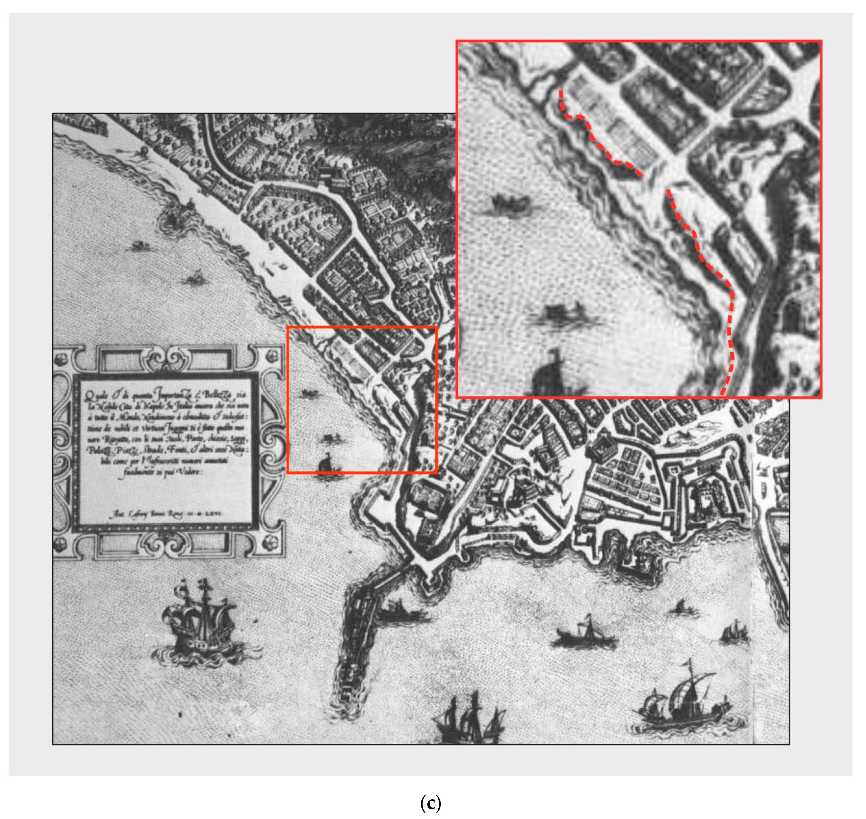
| Map of Naples by Lafrery | Jpg—free source | 1566 |
© 2020 by the authors. Licensee MDPI, Basel, Switzerland. This article is an open access article distributed under the terms and conditions of the Creative Commons Attribution (CC BY) license (http://creativecommons.org/licenses/by/4.0/).
Share and Cite
Mattei, G.; Aucelli, P.P.C.; Caporizzo, C.; Rizzo, A.; Pappone, G. New Geomorphological and Historical Elements on Morpho-Evolutive Trends and Relative Sea-Level Changes of Naples Coast in the Last 6000 Years. Water 2020, 12, 2651. https://doi.org/10.3390/w12092651
Mattei G, Aucelli PPC, Caporizzo C, Rizzo A, Pappone G. New Geomorphological and Historical Elements on Morpho-Evolutive Trends and Relative Sea-Level Changes of Naples Coast in the Last 6000 Years. Water. 2020; 12(9):2651. https://doi.org/10.3390/w12092651
Chicago/Turabian StyleMattei, Gaia, Pietro P. C. Aucelli, Claudia Caporizzo, Angela Rizzo, and Gerardo Pappone. 2020. "New Geomorphological and Historical Elements on Morpho-Evolutive Trends and Relative Sea-Level Changes of Naples Coast in the Last 6000 Years" Water 12, no. 9: 2651. https://doi.org/10.3390/w12092651