Article

Alternatives for Recovering the Ecosystem Services and Resilience of the Salamanca Island Natural Park, Colombia

1
Departamento de Ingeniería Civil y Ambiental, Universidad del Norte, Coastal Ecosystem Management Network (CEMAN), The World Association for Waterborne Transport Infrastructure (PIANC-Colombia), Red de Investigación en Ecohidrología y Ecohidráulica (REDECOHH), Barranquilla 081007, Colombia
2
Facultad de Ingeniería, Universidad Tecnológica de Bolívar, Grupo de Investigación de Sistemas Ambientales e Hidráulicos (GISAH), Coastal Ecosystem Management Network (CEMAN), Red de Investigación en Ecohidrología y Ecohidráulica (REDECOHH), Cartagena de Indias 130001, Colombia
3
Departamento de Desarrollo Rural y Regional, Facultad de Estudios Ambientales y Rurales, Pontificia Universidad Javeriana, Bogotá D.C 110211, Colombia
4
Red de Ambiente y Sustentabilidad, Instituto de Ecología, A.C. INECOL, Xalapa, Veracruz 91073, Mexico
5
Instituto de Ingeniería, Universidad Nacional Autónoma de México, Mexico D.F. 04510, Mexico
6
Departamento de Ingeniería Civil y Ambiental, Universidad del Norte, Barranquilla 081007, Colombia
7
Departamento de Economía, Universidad del Norte, Barranquilla 081007, Colombia
8
Departamento de Derecho, Universidad del Norte, Barranquilla 081007, Colombia
9
Departamento de Ingeniería Civil y Ambiental, Facultad de Ingeniería, Universidad de la Costa, Barranquilla 080002, Colombia
*
Author to whom correspondence should be addressed.
Water 2020, 12(5), 1513; https://doi.org/10.3390/w12051513
Submission received: 6 April 2020 / Revised: 9 May 2020 / Accepted: 14 May 2020 / Published: 25 May 2020
(This article belongs to the Special Issue Nature-Based Solutions for Coastal Engineering and Management)

Abstract

:
From a comprehensive diagnosis of the associated basins, islands, and wetlands of the coastal lagoon system of Ciénaga Grande de Santa Marta, Colombia, this work describes feasible options for the recovery of its ecosystem’s health and ecological resilience. Firstly, the state of the coastal lagoon was assessed, finding that hydrology, wave climate, and the morphological changes of the coastline explain recent changes in the coastal wetlands. Key variables were used to describe the level of conservation or degradation of the coastal lagoon system and to identify measures to improve its ecological functions. Finally, to mimic some of these functions and improve connectivity of the ecosystems, green infrastructure alternatives were proposed for the short and medium term to recover the services of these ecosystems and restore their resilience.

1. Introduction

A coastal lagoon is a body of water separated from the ocean by a coastal bar, spit, or barrier island and has a dynamically fragile ecologic equilibrium [1]. The processes of flooding and drying through natural or artificial channels to other water bodies determine the presence of different types of ecosystems [2]. Coastal processes also have a major role in the dynamics of a coastal wetland, not only influencing the hydrosedimentary regime, but also changing the physicochemical features of the wetland. For instance, tidal currents and sediment transport [3], as well as the variations of the phreatic level associated with the seawater, freshwater interaction, and wind action, all have significant effects on the ecosystem functions of a coastal wetland. Due to the diversity of the structures and processes of coastal ecosystems, they offer many valuable ecosystem services which improve the wellbeing of coastal communities [4]. Despite this social relevance, coastal ecosystems are among the most threatened ecosystems in the world, with urbanization, population growth, infrastructure development, and pollution all modifying their structure, functions, and services [5].
Ciénaga Grande de Santa Marta (CGSM) is the largest and most important coastal wetland in Colombia [6]. The lagoon system is on the Caribbean coast and receives inflows from the River Magdalena and the Sierra Nevada. CGSM has been a RAMSAR site (a wetland of international importance under the Ramsar Convention or Convention on Wetlands established by UNESCO) since 1988, the first in Colombia, due to its high biodiversity and social importance. In 2000, CGSM was declared one of the 391 United Nations Educational, Scientific and Cultural Organization (UNESCO) Biosphere Reserves because of its highly diverse terrestrial and marine ecosystems. In 2001, CGSM was designated an Important Bird Area (IBA)/Important Area for Bird Conservation (AICA) by Birdlife International and the International Union for Conservation of Nature (IUNC). At a national level, in 1964, part of the CGSM system was granted special status as a national park, the Salamanca Island Road Park (SIRP). This complex area of plains, lagoons, and forests is part of the delta–estuarine system of the River Magdalena. CGSM is the most productive lagoon in the tropics due to its hydrogeochemical and biological features [7]. These are the characteristics which make it home to a wide diversity of fauna, including species of commercial interest; 3500 fishermen had catches totaling 450 tons per month in 2018 [8].
Notwithstanding the physical, ecological, and social importance of CGSM, the lagoon system has been affected by many anthropogenic impacts over the last 60 years, such as deforestation, land use changes, water pollution, freshwater extraction, restriction of water flows and coastal erosion [9,10]. The hydraulics of the wetlands are also affected by flow deviations caused by hydraulic schemes, such as dykes and locks [11]. On the marine boundary, more human actions disturb CGSM, including the loss of mangrove forests, destruction of the dunes, disruption of coastal processes, disposal of wastewater and solid waste at sea and in the coastal wetland, alterations to water quality from the transportation of coal and harbor operations, sedimentation of the lagoon, and the building of infrastructure inside the Salamanca Island Natural Park. Coastal erosion is a severe problem on the main road linking Barranquilla and Santa Marta, the two main cities of the region, especially at Km 19, and near the villages of Tasajera, Pueblo Viejo, and the town of Ciénaga. This impacts the equilibrium of the ecosystems, as well as the social and economic wellbeing of the communities.
Initiatives designed to protect coastal resources in the area have often focused on short-term improvements or been implemented in specific periods as a response to political interests. Unfortunately, such strategies and initiatives are unlikely to generate positive effects in the long term, e.g., the rock armor constructed at Km 19 on the Barranquilla–Santa Marta road; the groins located in front of the Tasajera, Pueblo Viejo, and Ciénaga municipalities. Frequently, poorly designed projects have simply transferred and increased the problems to other localities in a cycle where the issues are repeated again and again. In recent decades, decision-makers have begun to include ecological concepts in management plans and coastal protection. However, most coastal interventions show a lack of knowledge concerning coastal processes. The current engineering works addressing the socio-ecological problems faced by coastal communities in the medium and long term are rarely compatible with development activities. Innovative management of the CGSM system through comprehensive strategies is urgent, but little is known about the links those strategies have with the structure and functions of the system. In some cases, in a complex environment like CGSM, interventions increase the uncertainties about its management rather than tackle structural problems. Given this scenario, it is essential to develop measures that would mitigate or reduce negative impacts on marine and coastal zones in the long term, such as ecosystem-based management (EbM) strategies and green infrastructure.
EbM has two main components [12]: (a) it offers a holistic framework for defining public policies in adapting long-term land management strategies and (b) at all levels of governance, it helps local communities to prepare for climate change through water resource management, disaster prevention, sustainable economic development, and the conservation of biodiversity.
The term “green infrastructure” (e.g., [13]) is a broad term to describe an option that ensures integrity of ecosystem functioning while responding to economic, social, and developmental demands. It is a comprehensive concept that includes the use of natural, semi-natural, or artificial infrastructure that enhances conservation of biodiversity and improves provision of ecosystem services. The concept aims to establish connections between human actions and ecosystem health, resistance, and resilience and to produce a reference framework for conservation, restoration, and development which benefits nature and the community in the long term.
The main goal of this research is to perform a comprehensive diagnosis of the Ciénaga Grande de Santa Marta (CGSM) lagoon system, including physical, ecological, and socio-economic features. Then, a set of green infrastructure alternatives with an EbM approach to deal with the main threats and pressures are suggested.

2. Materials and Methods
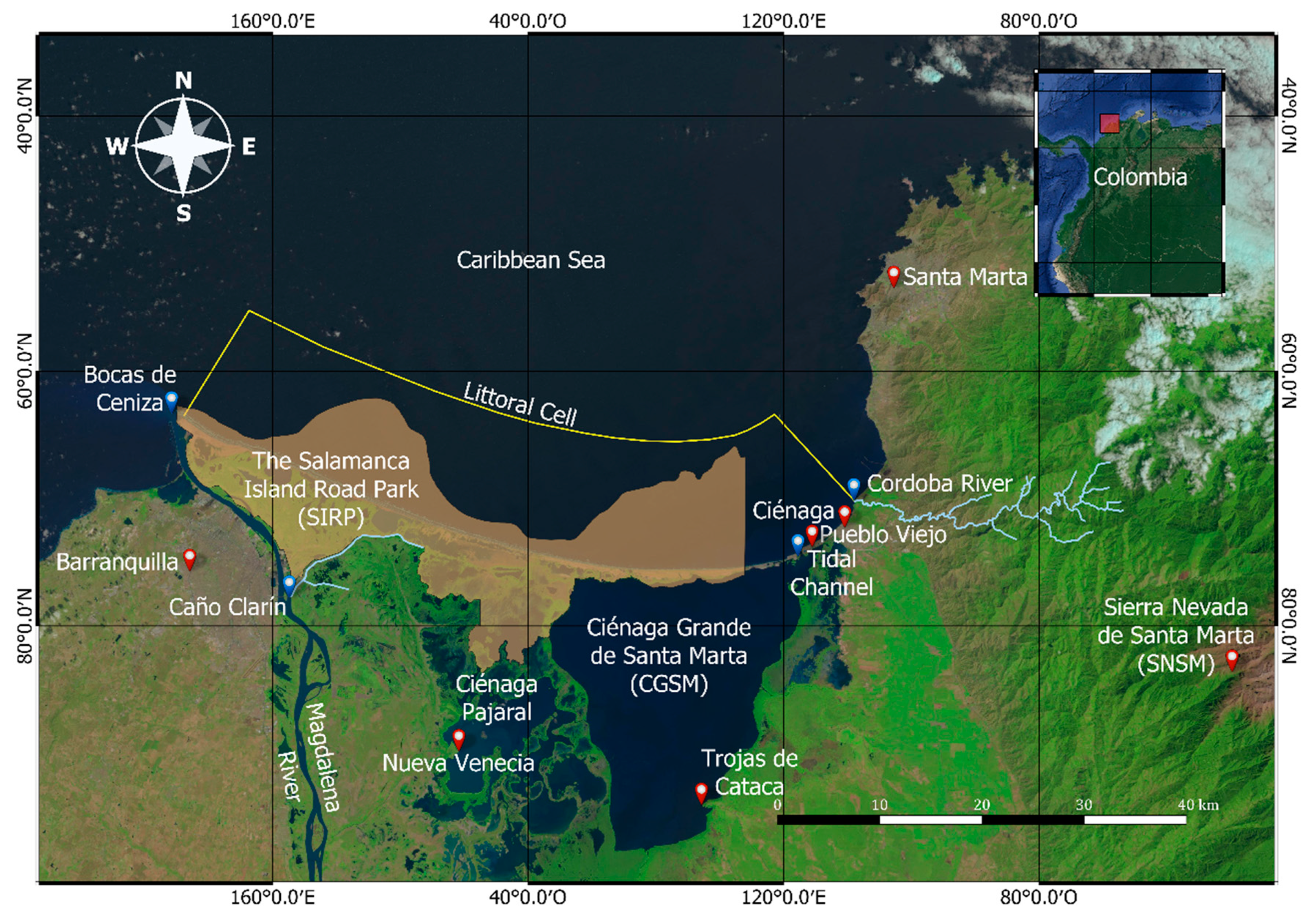
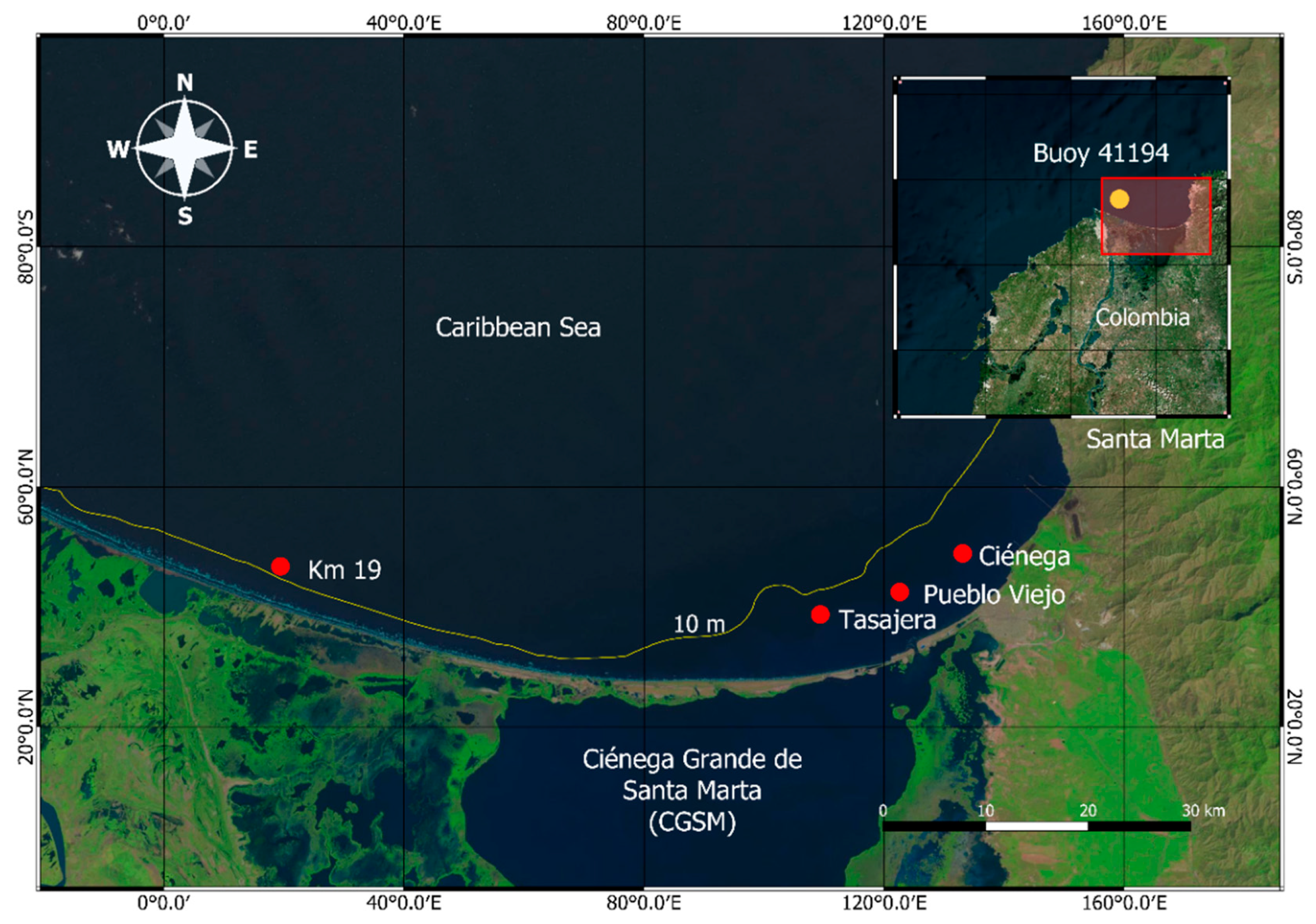
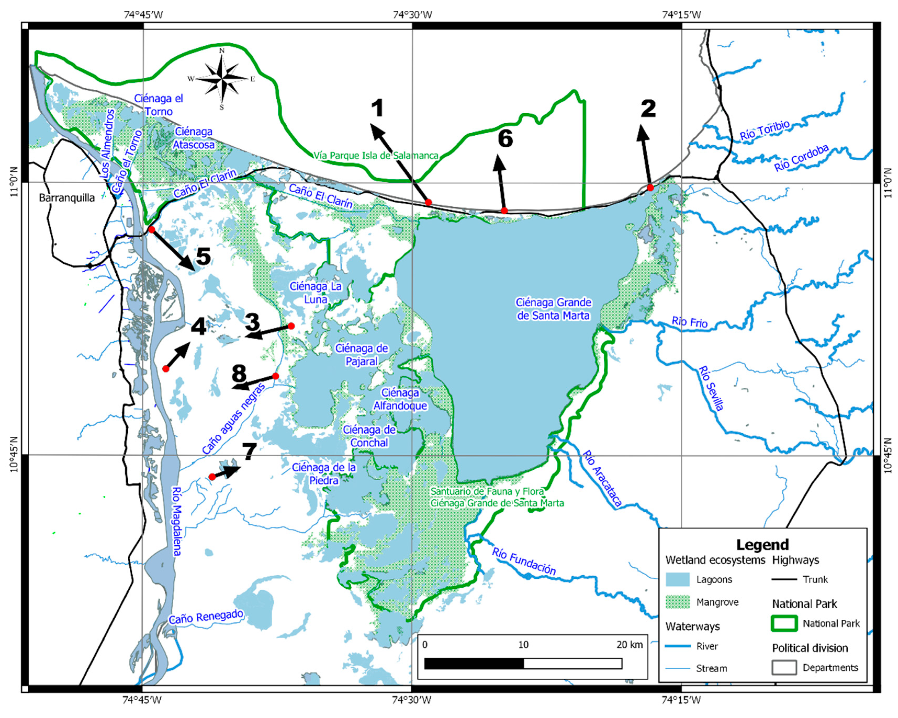
The diagnosis follows the framework proposed in [12] using the information available and the best practice experiences. Information on the physical, ecological, and socio-economic components was included. The amount of data available ranged from the minimum indispensable to the ideal, taking in consideration that some decisions have to be made with the information available, even if it is not always possible to access reliable, long-term information.

2.1. Study Area

CGSM is a sanctuary of fauna and flora with water bodies that are part of the ancient Magdalena river delta (Figure 1). The area was formed by the progressive accumulation of sediments and includes mangrove, swamp, and marsh ecosystems. The River Magdalena is the most important fluvial system and waterway in Colombia, crossing the country from South to North, with great importance in terms of its ecosystems, as well as for the economy. The 1280 km2 of CGSM is composed of coastal lagoons with estuarine behavior, paleochannels of the River Magdalena and extensive mangrove forests [14]. The wetland complex has two main water bodies: Ciénaga Grande Coastal Lagoon and Ciénaga de Pajaral, as well as other small wetlands, which are interconnected at times of high rainfall.
Within CGSM, the Salamanca Island Road Park (SIRP) is bordered by the Caribbean Sea to the north, the lagoon of Pajaral and Caño Clarín to the south (Figure 1), the village of Pueblo Viejo to the east, and, the River Magdalena and the city of Barranquilla to the west. It is an important zone for fish reproduction and for the artisan fishing economy of villages such as Nueva Venecia (El Morro) and Trojas de Cataca, which are built on wooden piles in the lagoons, as well as other fishing communities.
To the east of the Ciénaga Grande lagoon is Sierra Nevada de Santa Marta (SNSM), the highest coastal snow peak in the world, 5800 m above sea level. Substantial volumes of groundwater run from the mountain to the lagoon system. According to [15], the average discharge from the mountain is 19.25 m3/s.
The Ciénaga Grande lagoon is bordered to the north by the Caribbean Sea with sandy beaches of terrigenous origin and barrier islands with tidal channels linking the coastal wetland with the sea. The littoral cell (yellow line in Figure 1) is bordered to the west by Bocas de Ceniza on the River Magdalena. The lagoon is bordered by flood plains in the south, and by SNSM and the hydric subzone in the east [16] (Figure 2). The main physical processes affecting the water body are related to tidal exchange, sediment transport from the upper basin of SNSM to the wetlands and coastal border, level variations in the lagoon influenced by river discharge, as well as wind action, hydrometeorology, and convective storms.
According to [17,18,19] the climate of the Caribbean is characterized by four seasons: the main dry season, December–January–February (DJF), the secondary wet season, March–April–May (MAM), the short dry season, June–July–August (JJA), and the main wet season, September–October–November (SON). In this region of the Caribbean, in the main dry season, precipitation is low and winds are strong, coming from the North/Northeast. The North–South pressure gradient in the Caribbean from the midwinter to spring of the Northern Hemisphere creates gale force winds, of over 10 m/s−1. The main synoptic-scale feature in this period is the passage of cold fronts. For the rest of the year, including the secondary dry season (June–August) and the main wet season (September–November), the region is influenced by cyclonic activity, such as the passage of easterly waves, tropical storms, and the influence of remote hurricanes [20].

2.2. Data and Materials

The morphometry of the watersheds related to CGSM (Figure 2) is based on the zonation and codification data of the hydrographic and hydrogeological units of Instituto de Hidrología, Meteorología y Estudios Ambientales (IDEAM) [21]. The area of interest is part of hydrographic zone ZH 29 [21].
The description of the quality of vegetation was based on information from Moderate Resolution Imaging Spectroradiometer (MODIS) of National Aeronautics and Space Administration (NASA), 2003 and 2016, using the dataset of [22].
The data used for the implementation of the Simulating Waves Nearshore (SWAN) model [23] were as follows: large-scale bathymetry, wave climate, and wind regime. The large-scale bathymetry of the Colombian Caribbean comes from the General Bathymetric Chart of the Ocean (GEBCO) [24] with a land resolution at 30 arc-second intervals. The computational domain was between 10° and 12° north and 76.30° and 74.30° west with 100 nodes in the x-direction and 87 in the y-direction and a spatial resolution of 2.5 km. The data used for the wave boundary conditions were obtained from National Oceanic and Atmospheric Administration (NOAA) WAVEWATCH III, 1979–2009, downloaded from https://polar.ncep.noaa.gov/waves/hindcasts/nopp-phase2/. The wind data for forcing the model were obtained from JRA-55 [25] downloaded from https://rda.ucar.edu/datasets/ds628.0/. The model was calibrated using the data from wave buoy 41,194 (Barranquilla) of the Colombian Dirección General Marítima (DIMAR).
The data used for the wetland and beach analysis are from the in situ experimental work of the coastal erosion project for Guajira and Magdalena, 2016–2017, funded by Ministerio de Ciencia, Tecnología e Innovación (Colciencias), the national science funding agency of Colombia [26]. In this project, beach profile and bathymetry measurements, sediment sampling, and geotechnical data were collected to determine the causes and consequences of the coastal erosion problems in all the littoral cell [26].

2.3. Methods

A general characterization of physical, biological, ecological, socio-economic, and governance elements was performed to establish a baseline of the current state of the system.

2.3.1. Basin Analysis

The level of intervention in the basin was determined through the quality of the vegetation and changes to the river discharges. Vegetation quality was measured with the normalized difference vegetation index (NDVI); 0 indicates low quality or no vegetation, 1—excellent quality. The dataset of [22] for the Colombian Caribbean region, 2003–2016, was used. The time records of river discharges were analyzed in order to identify when water is extracted for agricultural activities and to establish the level of ecological impact due to interventions in the basin. This hydrological information can be associated with mangrove cover and land use change, salinity variation, erosion, river mouth sedimentation, and hydrodynamic changes. Geospatial analysis, time series analysis, and generation of cartographic products were performed using the QGIS, SAGA, and Python tools.

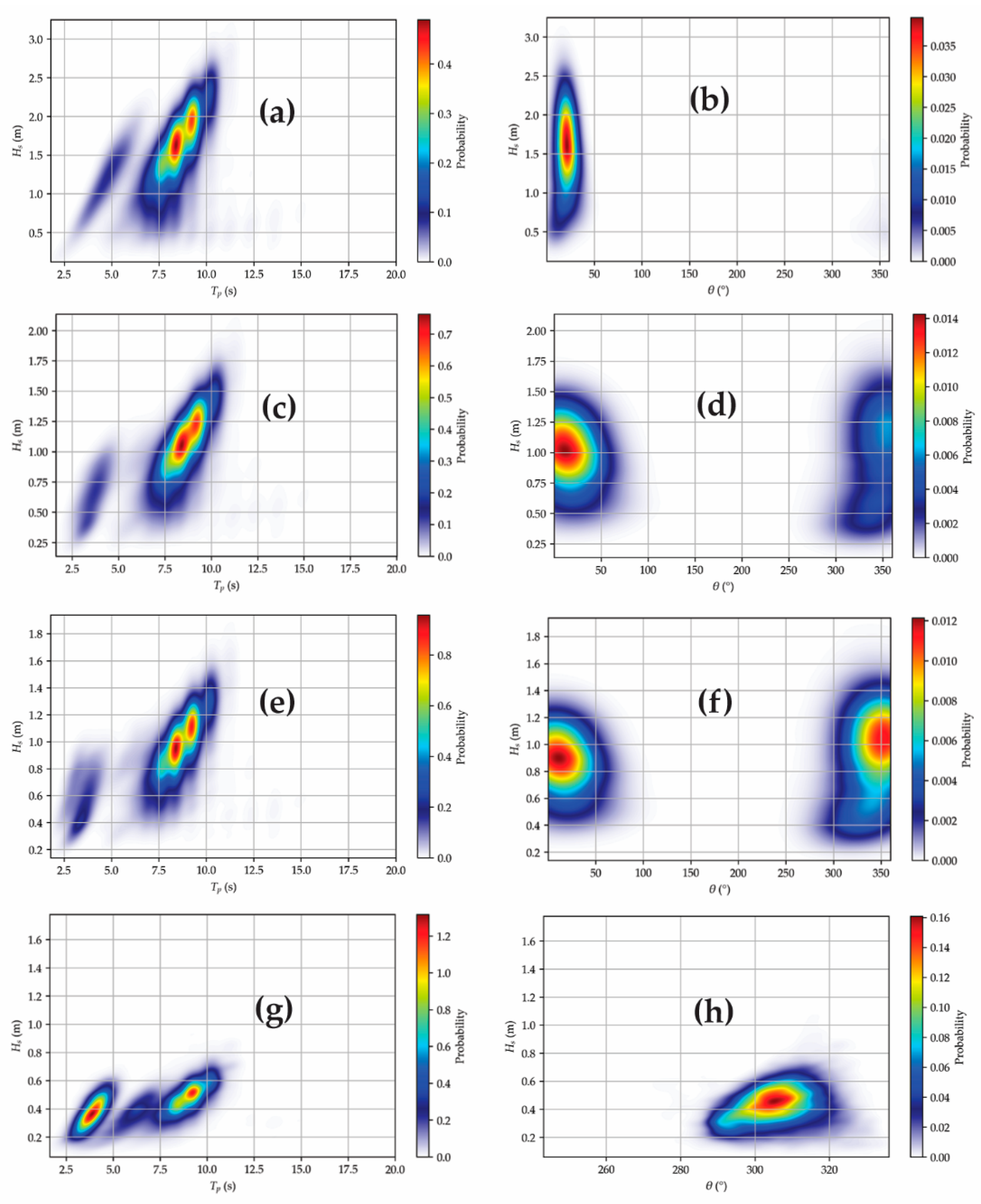
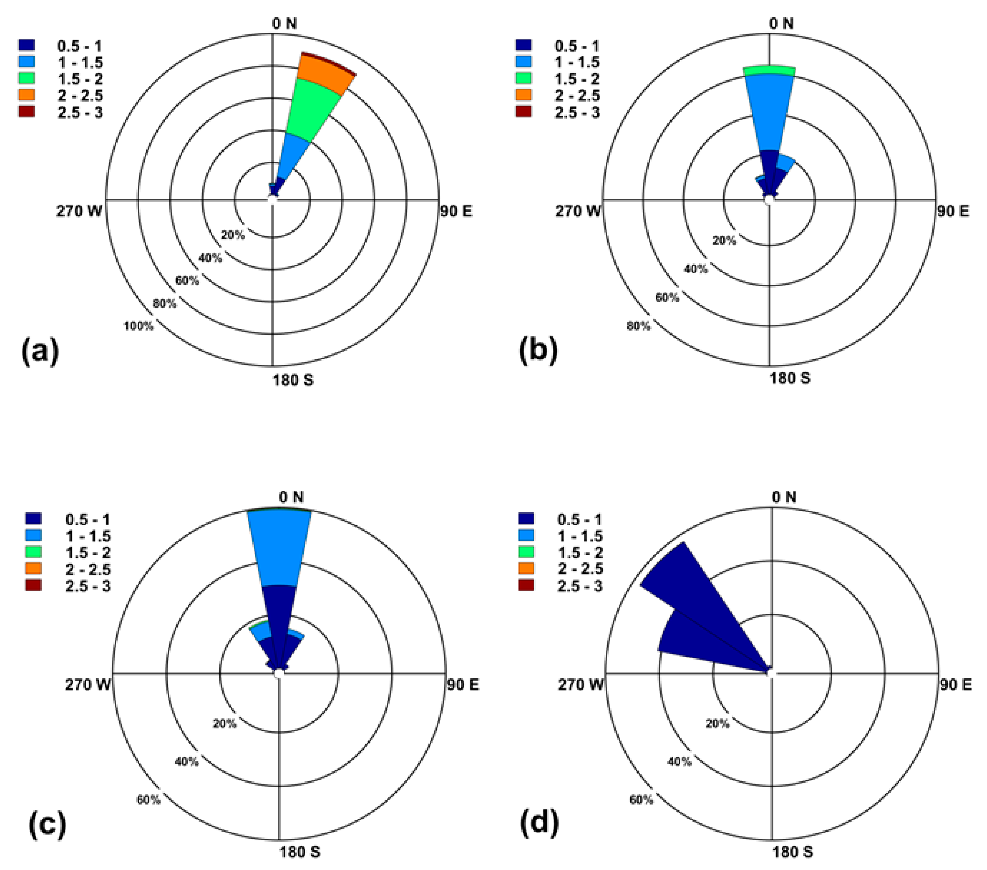
2.3.2. Wave Climate Analysis

The main problems of CGSM are associated with the loss of mangrove forest and coastal erosion. Therefore, it is important to understand the direction and magnitude of the net sediment transport. Wave propagation from deep to shallow water was calculated with the SWAN model [23]. The model was run over 30 years, from 1 January 1979, to 31 December 2009. The directional space was discretized in 36 directions with separations of 10 degrees. For wave development, the parameterization of [27] was used. Bottom friction [28], nonlinear triad interaction [29], and quadruplets [30] were used. The results of the model were calibrated using in situ the data of a wave buoy belonging to DIMAR, Colombia, at the following coordinates: 11.161° N and 74.681° W. Times series of the measured and modeled significant wave heights were compared, giving a Pearson correlation coefficient of 0.784. The mean absolute error was 0.26 m, and the percent error was 12%. Time series of significant wave height, peak period, and wave direction were taken from the 30 years of modeling for four locations in the study area, at 10 m water depth in front of the town of Ciénaga, off the villages of Pueblo Viejo and Tasajera, and in front of Km 19 on the Barranquilla–Santa Marta road, the places with the worst erosion problems. Means and long-term statistical analysis was performed on these time series considering joint probability distributions of wave height and direction, wave height and period, roses of significant wave height and period. Long-term analysis using the maximum annual values of significant wave height adjusted to the Weibull distribution was also performed.

2.3.3. Ecological and Social Characterization

Ecological changes in CGSM were identified using the regime shifts approach [31]. Regime shifts are large, abrupt, and persistent changes in the function and structure of ecosystems [32]. Here, a change is related to a regime shift when (i) a large change or reorganization of the system has been observed, (ii) the change affects provision of ecosystem services and has consequences for human wellbeing, and (iii) there are feedback mechanisms that create and maintain the regime, thus making the change persistent and challenging to reverse. We tracked significant changes in the structure of the ecosystems and socio-economic consequences of CGSM in scientific literature over the last 40 years.

2.3.4. Governance System

The governance structure was analyzed with the motif-based analytical framework proposed by [33], which relates governance effectiveness to governance complexity. To this end, we had to identify the actors of the system, their roles, and connectivity. We focused on the fishing resources given their importance for the communities in the area. The data sources used were the latest national population census, 2018, and primary data collection. Two surveys were carried out: (i) a socio-economic survey (n = 500) and (ii) a social network analysis (SNA) survey of fishing co-ops (n = 25). The socio-economic survey was carried out in August–October 2017. We interviewed 500 randomly selected adults following a face-to-face protocol in the municipalities of Ciénaga, Sitio Nuevo, and Pueblo Viejo. In the SNA, we used a snowball sampling procedure and interviewed 25 co-ops in July–August 2018. The survey characterizes the co-ops, the cooperation network, and the relations with environmental authorities. Finally, through document analysis and participant observation in various participatory processes involving fishermen and environmental authorities, we identified the roles of these actors and their relationships.

3. Results

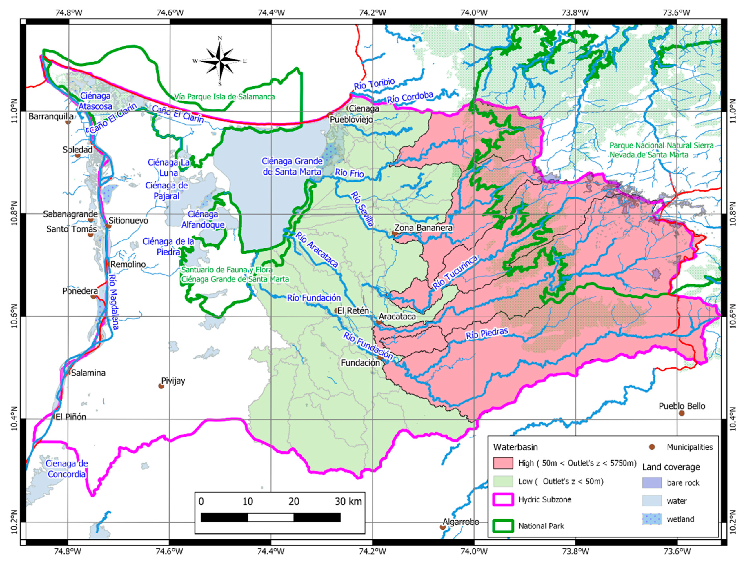
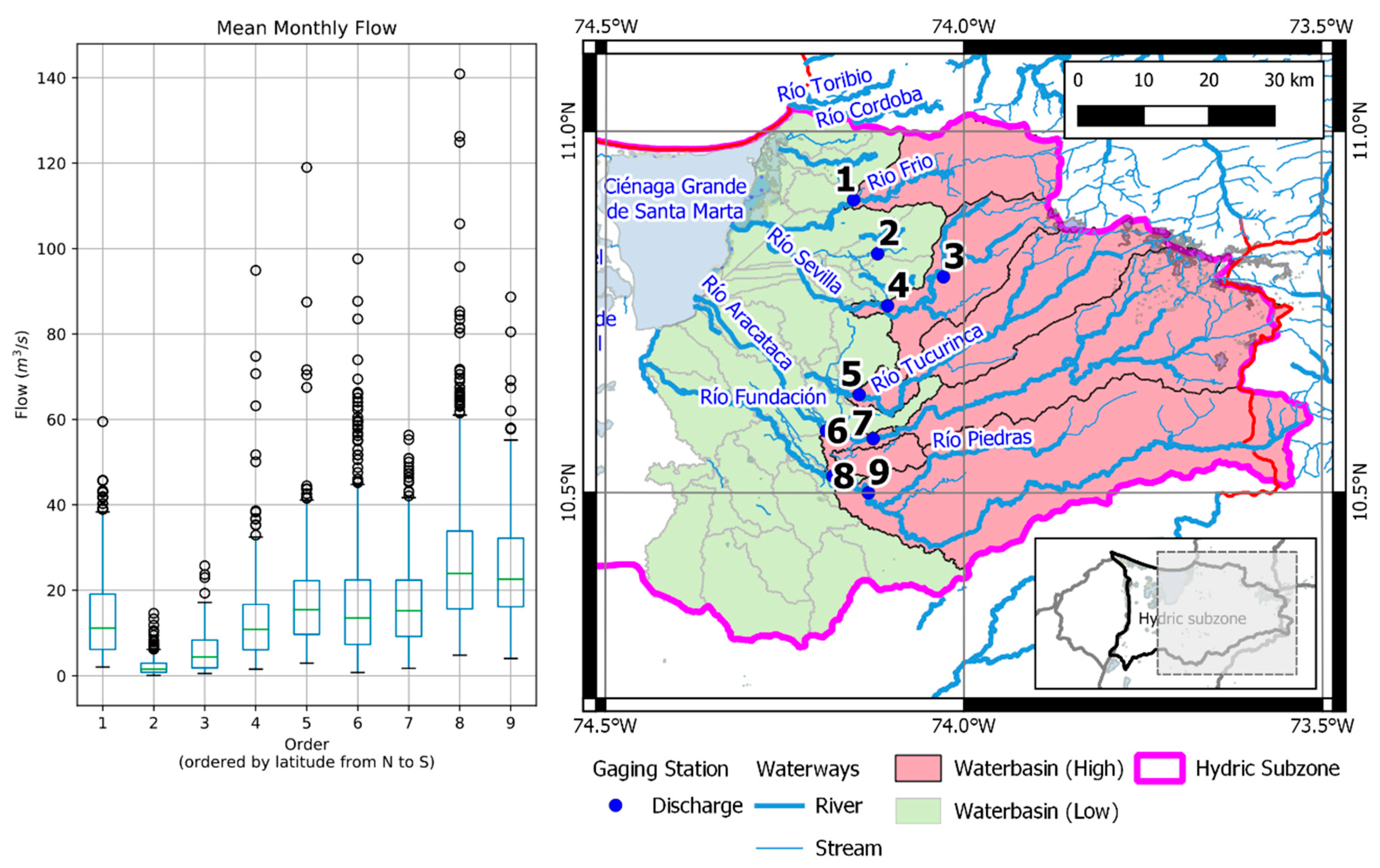
3.1. Integrated Basin Management

The CGSM system is influenced by the river water flowing from SNSM, the streamflow associated with the flood plain areas east of the Magdalena River, and the flux from the area west of the wetland, from the town of El Piñon to Sitio Nuevo. The area of these two basins is 8230 km2 (Figure 2); 2940 km2 belong to the Sierra Nevada mountain system and the basins of the rivers Frío, Sevilla, Aracataca, and Fundación, east of the Troncal del Magdalena road.
The estimation of the mass balance was calculated from the inflow and water losses in the lagoon complex. This estimation is particularly important because of the alterations induced by intense agriculture in the lower basin (Figure 3). The effects of agriculture could be inferred from the difference between discharge records upstream and downstream, where there are irrigated crops. The basins of CGSM, Frío, and Aracataca, are between 3000 and 4500 m.a.s.l. and the rivers have an annual mean discharge of 2135 million m3/s.
The loss of hydrological connectivity associated with changes at the CGSM and Pajarales lagoons is related to changes in the hydrodynamics of the River Magdalena and channels coming from SNSM and to physical alterations of the wetlands. These processes often feed on each other and have different temporal and spatial scales. Botero et al. [9] explained the changes in the lagoon system as a consequence of (a) hydrodynamic changes induced by the construction of embankments and weirs by environmental entities and local communities, (b) synergic effects between hydrological processes (exchange of saline and freshwater, sediment flows), (c) biogeochemical processes (enrichment with organic matter and inorganic nutrients), and d) ecological processes (direct alterations in the structure of biotic communities). The consequent dynamic processes affect the ecosystems at different levels, and also the ecological functionality, which in turn affects ecosystem services.
The freshwater inflows into the Pajarales and CGSM lagoons are affected by the modifications to the hydrodynamics (e.g., dams and hydraulic structures in the basins). Salinity levels increase with the incoming flow through the inlets due to the tides. In the network of paleochannels from the Magdalena River, the sediment dynamics are affected by the reduction in the velocity field induced by infrastructure. The deforestation in the basins of rivers coming from SNSM increases sediment transport, inducing sedimentation downstream, at the mouths of those rivers. The alterations described above, along with the discharge of organic matter, affect the structure of biotic communities.
Dams constructed in the Aguas Negras and Renegado channels affect connectivity between the river and the wetlands [34]. Those dams are in a zone controlled by illegal armed groups, and as no access is granted, we are reporting this based on word of mouth, from local people. Flow alterations of 6 to 10% may have occurred as a result of the damming. The most significant modification to the dynamics of the system is related to the water levels and flooding regime [34].
Figure 4 (panel A) shows the seasonal vegetation patterns for the first three months of the year. The level of vegetation cover is low (yellow and red), especially north of the town of Pivijay. There is bare soil and snow in the highest areas of SNSM. From July to November (panel B), there is almost complete recovery in the vegetation, reaching high levels (green) in most of the hydric subzone [16].

3.2. Wave Analysis

The nearshore wave climate was analyzed at 10 m depth for four locations; off Km 19 and near the villages of Tasajera, Pueblo Viejo, and the Town of Ciénaga (Figure 5). The results show a significant change in the conditions from east to west (Figure 6). At Km 19, wave heights of between 1.5 m and 2.0 m associated with periods of 8 s to 10 s were the most common conditions. In front of Tasajera and Pueblo Viejo, the wave heights were mostly between 1 and 1.25 m, with similar periods. Figure 6 also shows wave heights of 0.25 to 0.7 m with periods between 2 and 5 s and between 8 and 10 s off Ciénaga.
The spatial variation of wave height and direction is shown to explain the variations in potential sediment transport. The annual wave height roses are shown in Figure 7. At Km 19 (Figure 7a), 94% of the waves come from north-north-east with a maximum value of 3.1 m. At Tasajera (Figure 7b), 66% of the waves come from north with a maximum value of 1.6 m, 21% come from north-north-east, and 11%—from north-north-west. At Pueblo Viejo (Figure 7c), 60% of the waves come from north with a maximum value of 1.5 m, 19% come from north-north-west, and 16% come from north-north-east with maximum values of 1.6 m. At Ciénaga (Figure 7d), 58% of the waves come from north-west and 42%—from west-north-west, with maximum wave heights of around 0.8 m.
The joint probability distributions of significant wave height and mean wave direction (Figure 6b,d,f,h)) and the wave rose plots Figure 7 indicate a significant reduction in wave height from west to east, as well as spatial changes in direction. Waves come from north-north-east and north-east at Km 19, from north, north-north-west and north-north-east at Tasajera and Pueblo Viejo, and from north-west and west-north-west at Ciénaga. These alongshore and alongshelf variations in wave height and direction are due to refraction effects, which are related to the variations in the inner shelf width and the orientation from west to east.
The distribution of mean wave directions is mainly from north, north-east, and north-north-east at Km 19, Tasajera, and Pueblo Viejo and shows the highest wave energy in the main dry season (December to March) and then in the secondary wet season (March–May), when winds come from north-east and cold fronts are the dominant synoptic phenomena. Previous studies, e.g., [35], established that the extreme waves in the study area are mainly related to the cold fronts and are less energetic in the cyclonic season, June–November.
The larger waves found towards the west imply that the wave-induced potential sediment transport increases in that direction, which could explain some of the erosion processes observed at Km 19.

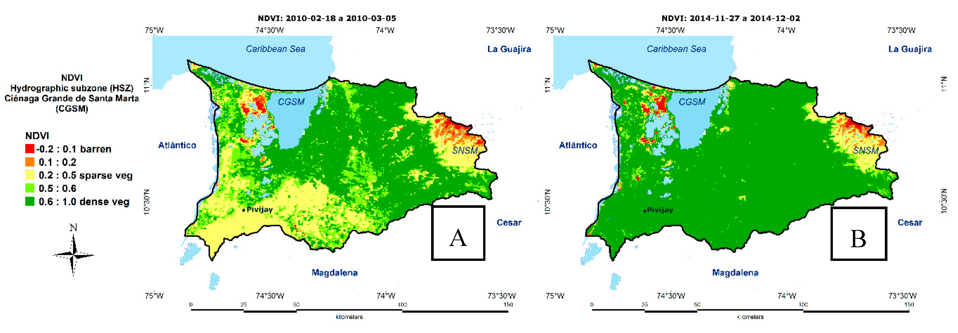
3.3. Relevant Ecological Aspects of CGSM

Policy decisions in CGSM have led to physical alterations, ecological deterioration and a loss of ecosystem services (Figure 8). For example, in the coastal zone, almost half of the original mangrove (511.5 km2) has disappeared due to deforestation and tree mortality related to flood protection projects and construction of roads [15,36,37]. Botero et al. [9] described the effects of building the Ciénaga–Barranquilla road in 1956 on the connectivity between terrestrial and marine systems. Further episodes of ecological deterioration were related to the construction of dykes, roads, and dredging between 1960 and 1976 when dykes were built to protect farmland from flooding by the River Magdalena and the Palermo–Sitio Nuevo–Remolino highway was built. Then, in the 1980s and 1990s, box culverts were built on the Ciénaga–Barranquilla road to improve connectivity between the tributaries and the Magdalena River [15]. These projects modified the hydrosedimentary fluxes in the lagoon system and triggered changes in water quality and other physicochemical and biological parameters (Table 1). Then, from 2000 to 2010, dredging works on the artificial channels were undertaken to restore two tributaries (Caño Clarín and Aguas Negras) that had lost hydraulic functionality due to the sediment load and the subsequent colonization by aquatic vegetation. Unfortunately, the evidence suggests that this dredging aggravated the loss of the system’s hydrological connectivity [11].
The changes in the Ciénaga Grande lagoon system are summarized in Table 1. It can be seen that from 1980 to 1990, there was a large increase of inorganic nutrients (NO3, PO4, NO4 and NH4) in the water body. This over-enrichment of nutrients increased the chlorophyll concentration and phytoplankton density, affecting the oyster banks, reducing the quantity and size of oysters. After 1996, the sediment load reduced the depth of the lagoon [38,39]. Dominance in the algal community moved from diatoms towards Cyanophyta, as well as to a growing predominance of such genera as Anabaena spp., Anabaenopsis spp., and Microcystis spp. [40,41].
Residues from farming and domestic waste discharges are the main sources of pollution in the lagoon when considering solids, nitrogen, phosphorus, and fecal microorganisms. This contamination is a risk for human health, flora, and fauna in the CGSM system [42]. Cultivation of bananas, oil palm, and rice is one of the main reasons for the increase in heavy metals (Pb, Cd, Cu, Cr, Zn, Ni, Hg) around the rivers Aracataca, Sevilla, and Fundación. The use of fertilizers and pesticides generates social conflicts, because this limits the access to clean freshwater for the local communities [43].
The development of salt flats has increased mangrove mortality [36]. Simultaneously, the deterioration of the lagoon has led to socio-economic issues, such as the collapse of the fisheries. For example, in 1994, an anoxia event led to the death of 20 tons of fish of 14 species, some of them of great economic importance for the local communities. Also, algae blooms have caused fishkill events [40]. Fishing is the main economic activity in the study area, with around 3,000 families reliant on artisanal fisheries [44], so smaller catches mean that the fishermen must change their main employment to maintain their income. The old fishing communities of Nueva Venecia and Buena Vista have now excluded fish from their regular diet due to the fall in the number of fish caught.
The increase in the total of accumulated suspended solids in 1993–2007, is related to the sedimentation process in the lagoon and the consequent burial of the oyster banks (Crassostrea rhizophorae). From 1994 to 1996, the oyster harvest fell from 25 tons to just 1 ton. The reduction in the oyster population has, in turn, affected the mussel population (Mytilopsis sallei), whose substrate is oysters. Consequently, the population of striped mojarra (Eugerres plumieri) has been affected, since this is the main predator of mussels [45]. In 1994, catches of striped mojarra represented 23% of commercial fishing, but by 2007, this number had fallen to only 1% [45,46,47].

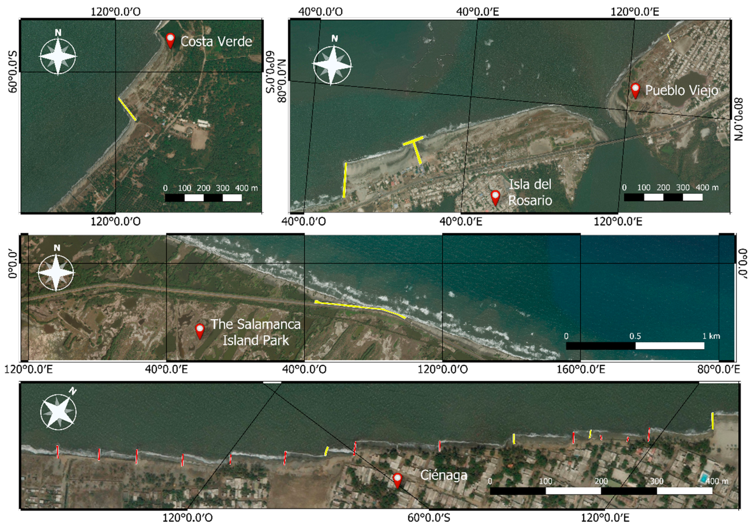
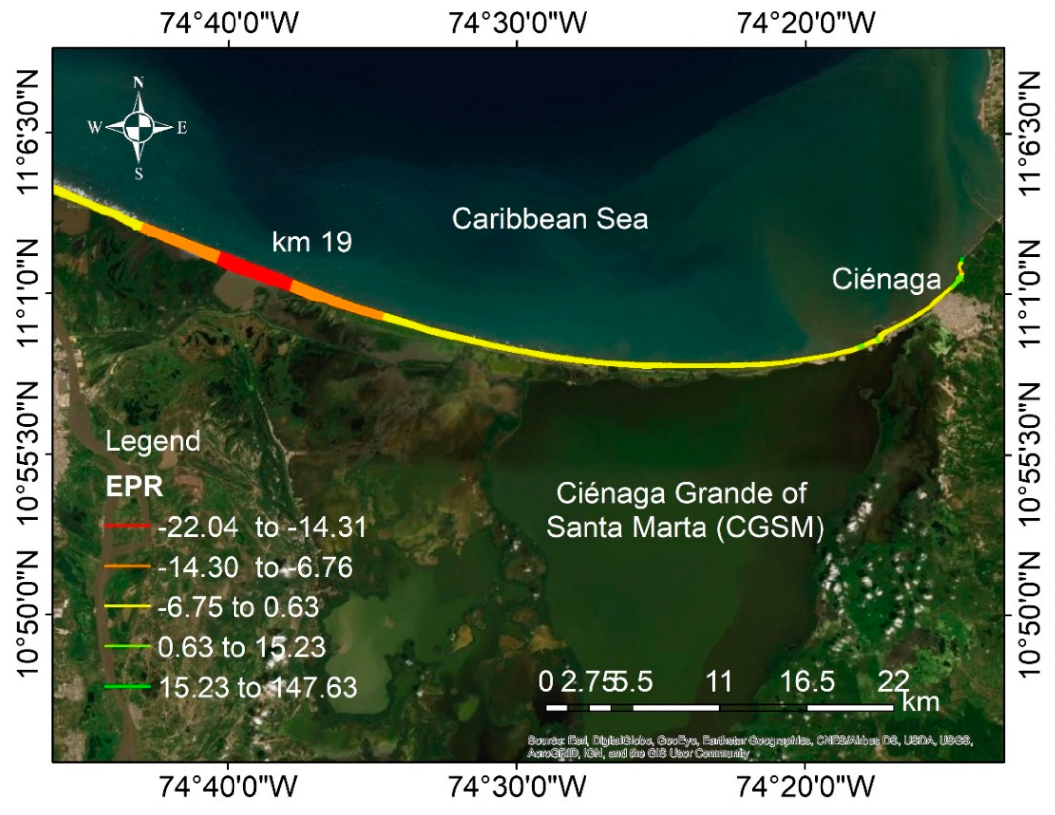
3.4. Coastal Wetlands and Beach Processes

Sediment transport
Disturbances in the coastal zone such as coastal erosion are caused by the imbalance of sediment resulting from hydrodynamic changes in CGSM and coastal protection schemes.
The modifications in beach profiles and dunes that were caused by human settlement were quantified through the analysis of littoral cells, shown in Figure 1 and Figure 9. The main purpose of this analysis was to identify sediment imbalances and characterize the sources of the sediments. Two important sediment sources were identified: the River Cordoba and the tidal channel in Tasajera (where beach morphodynamics are determined by the action of drift currents and the submerged bar off the Ciénaga municipality) and the marine sediment source activated in the dry season by extreme wave conditions. Based on this analysis, it is clear that some littoral cell sources provide sediment to the system, but that human interventions, like groins and dykes, disrupt the beach equilibrium and exacerbate the coastal erosion. Furthermore, in the last decade, the local government of Tasajera, Pueblo Viejo, and Ciénaga allowed the construction of houses on the dune system, severely affecting the coastal processes.
The groins built on the coast (Figure 9), supposedly to mitigate the erosion, quickly became the main cause of beach degradation despite the continued sediment supply in the littoral cell. Many other coastal protection works built near Ciénaga, Pueblo Viejo, and Tasajera have also exacerbated the coastal erosion problems as they have reduced the rates of sediment transport [26].
Coastal erosion
The spatial and temporal analysis of LANDSAT images, Figure 10, showed erosion and accretion processes in 1973–2016. It was found that hard coastal structures were not the best option to protect the coast from the retreat caused by erosion. The most critical place is at Km 19 on the Barranquilla–Santa Marta road with coastline recession of around 370 m in the last decades. Too often, these structures have simply moved the erosion further along the coast as longitudinal sediment transport was affected. In recent years, the coastal erosion rates of 0.63 m/year have not changed significantly in front of Ciénaga and Pueblo Viejo, but have reached −14.31 to −22.04 m/year at Km 19.

3.5. Stakeholders and Governance

We identify three entities as managing actors, who focus on fishing resources: (i) the National Parks unit, which manages Parque Isla Salamanca and Santuario de Flora y Fauna CGSM; (ii) the regional environmental authority, Corpamag; and (iii) fishing co-operatives. The National Parks unit is in charge of the management of the two protected areas, while Corpamag is responsible for the management outside these protected areas. The fishing co-operatives coordinate the efforts of their members and are the means through which fishermen interact with National Parks and Corpamag. The data gathered during the participatory process and from official and press documents show that environmental authorities concentrate on their jurisdiction and collaboration is limited to moments of crisis, for example, during serious episodes of fish mortality.
The SNA survey showed the following: (i) a low degree of cooperation between them, (ii) the cooperation that exists is mainly driven by geographical proximity and family links, and (iii) most co-operatives do not have a direct relationship with the environmental authorities. The fishermen, as a collective actor, are thus in a weak position to exert significant influence over management decisions of the environmental authorities.
The multidimensional index of poverty calculated from the 2018 census data shows that about 65% of the population in the area is considered poor. That is, they suffer from multiple disadvantages in terms of health and nutrition, access to clean water or electricity, work conditions, and schooling. Moreover, communities are highly dependent on the conditions of the ecosystem. Results from our socio-economic survey reveal that 51% of the respondents obtain part of their income from the exploitation of fishing resources, pointing to the importance of the link between the governance system and the wellbeing of the local population. We also found that the population do not have much trust in external governance actors. Using a seven-point Likert scale where 1 is “I do not trust them at all” and 7 is “I trust them a lot”, it was seen that Corpamag (mean 2.2) and National Parks (mean 4.4) have low levels of trust. So, cooperation among the managing actors of CGSM is weak, characterized by a lack of trust, which hinders their capacity to deal with challenges that require joint resource management across jurisdiction boundaries. The deteriorating environmental conditions in CGSM are clear indicators of a lack of sound governance.

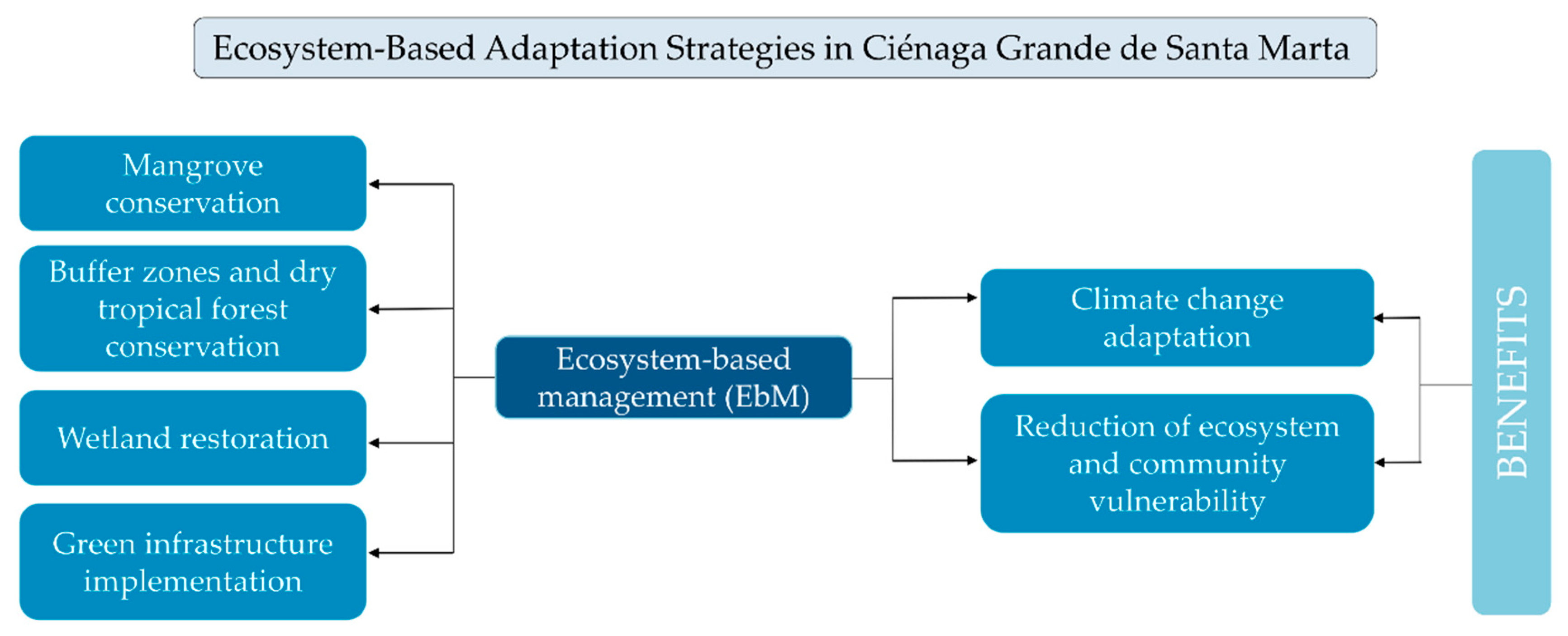
3.6. Proposed Options

The establishment of conceptual alternatives depends on the results of wave propagation, the morphological analysis, and the flow connectivity in the basin–wetland–coastal system. Therefore, a methodology proposed by [48] and cited by [49] was followed to evaluate the state of CGSM to find the possible causes of degradation and to propose restoration measures from a holistic point of view, measuring its impact in the long term.
Table 2 summarizes wetland characteristics, showing the anthropic factors and main physical variables that have a role in the equilibrium of the system. This hierarchical characterization is useful in identifying the critical negative impacts in CGSM, defining a detailed diagnosis and then selecting restoration strategies for the affected zones.
The next step was the identification of the causes and effects of degradation. Table 3 shows the status of CGSM in terms of erosion processes, fragmentation of coastal ecosystems, hydrological connectivity, and water quality.
Following the identification of the causes and effects, a list of recommendations to restore the system is offered. This list helps to identify the most urgent problems. Table 4 shows the list of alternatives for the restoration of CGSM.
With the above information, it is possible to develop conceptual designs and policies and the features to be monitored to evaluate the performance of the lagoon. The list is a starting point to be updated and modified by the stakeholders and local government.
The solutions proposed in this work constitute a hybrid project with three stages focused on recovering connectivity within the system from the mountains to the coast. Before any of these activities take place, monitoring of the system must define the exact locations, the timing, goals, and indicators for the evaluation of results.
I.
The restoration of riparian vegetation, water flows, and mouths: the reforestation of the basin, restoration of the water flows, and clearing of areas around the river mouths in the lagoon will improve the system in terms of storage capacity, nutrient cycles, and discharges, as well as lessening the risk of flooding.
II.
Mangrove recovery: mangrove reforestation using native species and restoration of critical fluxes will decrease salinity and increase the survival chances of the mangroves.
III.
Hybrid green infrastructure project: the littoral cell cannot be restored and requires an engineering project to recover its balance and connectivity. As an initial measure, living dykes are proposed, to reduce the reflection coefficients of the current rock armor. This type of dyke (Figure 11) allows the establishment of endemic vegetation to stabilize the dune. This kind of artificial dune is often used to restore littoral zones with critical erosion problems, as it enhances morphological restoration while efficiently reducing wave reflection.
One of the main advantages of this solution is that the coastal vegetation on the foredune will help to retain wind-transported sediment, thus naturally increasing the height of the dunes. The dune will cover the existing rock-core dyke. In a very strong sea state, the dune could erode, and then the rock armor structures would protect the road against wave and storm surge action [50].

4. Discussion and Conclusions

In summary, the changes in CGSM have been dynamic, non-linear, accumulative processes that have altered the ecosystem at many different levels. In the last decade, the actions concentrated on maintaining the inflow of freshwater from the River Magdalena, such as dredging the natural channels, have been prioritized. Meanwhile, supporting diversification of the livelihoods in the fishing communities through the implementation of productive projects has had limited results. The most important changes identified in the system are critical coastal erosion processes, disruption of the sediment transport due to coastal infrastructure, sediment imbalance caused by alterations in the river basins of SNSM, negative impacts in ecological communities, water quality problems, and losses in hydrological connectivity between the rivers and CGSM.
The coastline recession of the coastal bar was 350 m and there is a sediment imbalance of 50,000 m3 per year and erosion rates of 2 to 3 m per year in front of km 19 on the Barranquilla–Santa Marta road. Eighty percent of the freshwater of the SNSM rivers is lost to agricultural activities, and changes in land use exacerbate erosion in the basins of the rivers Aracataca, Río Frío, and Sevilla. At the local and national level, it is evident that the coastal management decisions in the past have not considered environmental and social factors. It is vital to find which areas are the most appropriate for future urban development and to avoid land use types and economic activities that exacerbate deterioration of the ecosystems.
The alternatives proposed here are based on the application of a simple methodology suitable in contexts where information is scarce and anthropic alterations are significant. To define a strategy which helps communities and natural systems to adapt to large-scale climate variations, the concept of ecosystem-based management (EbM) has been adopted [21]. The EbM approach (Figure 12) was selected, because it allows integration of economic activities and ecosystem conservation in the same plan. This type of solution can recover and strengthen ecosystems and involves local communities in management decisions. Applying this type of methodology increases the resilience of the ecosystem and reduces the vulnerability of human populations.
The results presented in Section 3 and their interpretation in the context of previous research is the base for the discussion of the alternative analysis for the SIRP presented in Table 4. This plan must include protection against waves, sea level rise, and coastal flooding (e.g., the micro-tsunami of 2016).
In line with the activities proposed within the EbM concept, a green infrastructure alternative is proposed for Km 19 of the SIRP [13]. The project includes transformation of the rock armor into a living dyke (Table 4). At this location, the littoral cell has been dramatically altered, and the site requires an engineering project while the coastal system recovers balance and connectivity. As an initial measure, the proposed living dykes would reduce the reflection coefficients of the rock armor currently in place to protect the coast, but which disrupt the longitudinal sediment transport and reduce the wave energy in this area. This alternative would protect the road between Barranquilla and Santa Marta.
An artificial reef is also proposed. This submerged structure has two main functions: (a) to reduce wave energy by inducing friction and turbulence; (b) to generate calm conditions, as do barrier coral reefs in the Caribbean. A green infrastructure alternative is also proposed, the construction of a living dyke, an embankment that allows the establishment of a dune system with local vegetation. Vegetation is key to retaining the sediment lost by wind transport. Once the system shows positive signs of restoration, reforestation must be carried out at the back of the dune with mangrove, taking into consideration the current physical conditions of the site. The salinity levels of the area must also be taken into account to ensure that the reforestation is successful in the long term. Because of the complexities of the site, the dynamics of the meteorological conditions and the anthropic impacts on CGSM, several green infrastructure projects are needed to restore the balance of the system.

Author Contributions

Conceptualisation, G.R.-O., M.A.M.-C., R.S.; methodology, G.R.-O., M.A.M.-C., R.S.; Ecological aspects, S.R.; Hydrology and basins analysis, A.S. Socio-economic assessment, A.V.; Legal review, J.P.S.; Wave modelling and analysis, M.A.M.-C., R.D.R., E.C.; Coastal erosion analysis M.B.; writing—original draft preparation, G.R.-O., M.A.M.-C., R.S., D.L.; writing—review and editing, G.R.-O., M.A.M.-C., R.S., D.L, J.C., D.C., D.R. All authors have read and agreed to the published version of the manuscript.

Funding

This research received no external funding.

Acknowledgments

The authors would like to acknowledge all the support given by Universidad del Norte, and Universidad Tecnológica de Bolívar through the scholarship program for Master degree and the management of the Research and Innovation office in both universities, National University of Mexico (UNAM), Exceed-Swindon Network, Red de Investigaciones en Ecohidrologia y Ecohidraulica (REDECOHH Network), and World Association for Waterborne Transport Infrastructure (PIANC) colombian chapter. Centro de Investigaciones Oceanográficas e Hidrográficas (CIOH) have our appreciation for the opportunity of exchanging ideas and knowledge with their scientific staff working in wave modelling. Dirección General Marítima (DIMAR) provided the wave buoy information used in this work. Last, but not least, thanks to the families of all the research personnel involved for their patience and stubborn belief in Coastal Ecosystem Management Network (CEMAN Network). Andrés Vargas would like to thank the financial support from Universidad del Norte through grant DIDI-201730.

Conflicts of Interest

The authors declare no conflict of interest.

References

  1. Kjerfve, B. Comparative Oceanography of Coastal Lagoons, Columbia South Carolina: Estuarine Variability; Wolfe, D.A., Ed.; Academic Press: Cambridge, MA, USA, 1986. [Google Scholar]
  2. Friedman, J.B. Adaptación a Los Impactos del Cambio Climático en Humedales Costeros del Golfo dE México—Vol I; Buenfil, Ed.; Secretaría de Medio Ambiente y Recursos Naturales Instituto Nacional de Ecología: Ciudad de México, Mexico, 2009. [Google Scholar]
  3. Brunn, P. Engineering Projects in Coastal Lagoons. Elsevier Oceanogr. Ser. 1994, 60, 507–533. [Google Scholar] [CrossRef]
  4. Barbier, E.B. Valuing Ecosystem Services for Coastal Wetland Protection and Restoration: Progress and Challenges. Resources 2013, 2, 213–230. [Google Scholar] [CrossRef] [Green Version]
  5. Rocha, J.; Yletyinen, J.; Biggs, R.; Blenckner, T.; Peterson, G. Marine regime shifts: Drivers and impacts on ecosystem services. Philos. Trans. B 2015, 370, 1–12. [Google Scholar] [CrossRef] [Green Version]
  6. Villardy, S.P.; González, J.A.; Martín-López, B.; Montes, C. Relantionships between hydrological regime and ecosystem services supply in a Caribbean coastal wetland: A social-ecological approach. Hydrol. Sci. J. 2011, 56, 1423–1435. [Google Scholar] [CrossRef] [Green Version]
  7. Rodríguez-Rodríguez, J.A.; Pineda, J.E.M.; Trujillo, L.V.P.; Rueda, M.E.; Ibarra, K.P. Ciénaga Grande de Santa Marta: The Largest lagoon-Delta Ecosystem in the Colombian Caribbean. In The Wetland Book II: Distribution, Description and Conservation; Springer: Dordrecht, The Netherlands, 2018; pp. 757–772. [Google Scholar]
  8. Blanco, J.A.; Viloria, E.A.; Naváez, B.J. ENSO and salinity changes in the Ciénaga Grande de Santa Marta coastal lagoon system, Colombian Caribbean. Estuar. Coast. Shelf Sci. 2006, 66, 157–167. [Google Scholar] [CrossRef]
  9. Botero, L.; Mancera-Pineda, J.E. Síntesis de los cambios de origen antrópico ocurridos en los últimos 40 años en la Ciénaga Grande de Santa Marta y Ciénaga de Pajarales. Rev. De La Acad. Colomb. De Cienc. Nat. Y Exactas 1996, 20, 466–474. [Google Scholar]
  10. Polanía, J.; Santos-Martínez, J.E.; Arboleda, L.B. The Coastal Lagoon Ciénaga Grande de Santa Marta, Colombia. Coast. Mar. Ecosyst. Lat. Am. 2001, 144, 33–45. [Google Scholar]
  11. Jaramillo, F.; Licero, L.; Åhlen, I.; Manzoni, S.; Rodríguez-Rodríguez, J.A.; Guittard, A.; Hylin, A.; Bolaños, J.; Jawitz, J.; Wdowinski, S.; et al. Effects of Hydroclimatic Change and Rehabilitation Activities on Salinity and Mangroves in the Ciénaga Grande de Santa Marta, Colombia. Wetlands 2018, 38, 755–767. [Google Scholar] [CrossRef] [Green Version]
  12. Silva, R.; Chávez, V.; Bouma, T.; van Tussenbroek, B.; Arkema, K.; Martínez, L.; Oumeraci, H.; Hyemans, J.; Osorio, A.; Mendoza, E.; et al. The incorporation of biophysical and social components in coastal management. Estuaries Coasts 2019, 1, 1–14. [Google Scholar] [CrossRef] [Green Version]
  13. Silva, R.; Lithgow, D.; Esteves, L.; Martínez, M.L.; Moreno-Casasola, P.; Martell, R.; Pereira, P.; Mendoza, E.; Campos-Cascaredo, A.; Grez, P.W.; et al. Coastal risk mitigation by green infraestructure in Latin America. Marit. Eng. 2017, 170, 39–54. [Google Scholar] [CrossRef]
  14. Silva, R.; Martínez, M.; Catalan, P.; Osorio, A.; Martell, R.; Fossati, M.; Miot, G.; Mariño-Tapia, I.; Pereira, P.; Cienfuegos, R.; et al. Present and future challenges of coastal erosion in Latin America. J. Coast. Res. 2010, 71, 1–16. [Google Scholar] [CrossRef]
  15. Botero, L.; Salzwedel, H. Rehabilitation of the Cienaga Grande of Santa Marta, a mangroove estuarine system in the Caribbean coast of Colombia. Ocean Coast. Manag. 1999, 42, 243–256. [Google Scholar] [CrossRef]
  16. Instituto Colombiano DE HidrologíA, Meteorología Y Adecuación DE Tierras. Resolución 00337; Instituto Colombiano DE HidrologíA, Meteorología Y Adecuación DE Tierras: Bogotá, Colombia, 1978.
  17. Osorio, A.F.; Montoya, R.D.; Ortiz, J.C.; Pelaez, D. Construction of synthetic ocean wave series along the Colombian Caribbean coast: A Wave Climate Analysis. Appl. Ocean Res. 2016, 56, 119–131. [Google Scholar] [CrossRef]
  18. Mesa, O.J.; Poveda, G.; Carvajal, L.F. Introduction to the climate of Colombia. Univ. Nac. De Colomb. 1997, 1, 390. [Google Scholar]
  19. Ruiz-Ochoa, M.A.; Franco, G.B. Variabilidad estacional e interanual del viento en los datos del re-análisis NCEP/NCAR en la cuenca Colombia, mar caribe. Avances en Recursos Hidráulicos 2009, 20. [Google Scholar]
  20. del Río-Colón, R.; Campo-Rojas, E.; Maza, M.; Rivillas-Ospina, G.; Guerrero, M.; Murillo, N.; Urbano, C.; Rodríguez-Rincón, J.; Horrillo-Caraballo, J.; Bolívar, M. SWAN model sensitivity analysis of whitecapping and quadruplets formulations off the Caribbean coast of Colombia using WWIII boundary conditions and JRA-55 wind forcing. J. Mar. Sci. Eng. 2020. In review. [Google Scholar]
  21. IDEAM. Zonificación y Codifiación de Unidades Hidrográficas e Hidrogeológocas de Colombia; Instituto de Hidrología, Meteorología y Estudios Ambientales: Bogotá, Colombia, 2013.
  22. Hoyos, N.; Correa-Metrio, A.; Sisa, A.; Ramos-Fabiel, M.A.; Espinosa, J.M.; Restrepo, J.C.; Escobar, J. The environmental envelope of fires in the Colombian Caribbean. Appl. Geogr. 2017, 84, 42–54. [Google Scholar] [CrossRef]
  23. Ris, R.C.; Holthuijsen, L.H.; Booji, N. A third generarion wave model for coastal regions: 2 verification. J. Geophys. Res. 1999, 104, 7667–7681. [Google Scholar] [CrossRef]
  24. GEBCO. General Bathymetric Chart of the Ocean; British Oceanographic Data Center: Liverpool, UK, 2003. [Google Scholar]
  25. Kobayashi, S.; Ota, Y.; Harada, Y.; Ebita, A.; Moriya, M.; Onoda, H.; Endo, H. The HRA-55 Reanalysis: General specifications and basic characteristics. J. Meteorol. Soc. Jpn. 2015, 93, 5–48. [Google Scholar] [CrossRef] [Green Version]
  26. Rivillas-Ospina, G.D.; Silva, R.; Mendoza, E.; Avila, H.; Daza, O.; Berrío, Y.; Ruiz, A.; Rueda, J. Coastal restoration on the barrier island of Ciénaga Grande, Magdalena, Colombia. In Proceedings of the Coasts & Ports Conference, Cairns, Australia, 21–23 June 2017; Volume 1, p. 5. [Google Scholar]
  27. Komen, G.J.; Hasselmann, K. On the existence of a fully developed wind sea-spectrum. J. Phys. Oceanogr. 1984, 14, 1271–1285. [Google Scholar] [CrossRef]
  28. Hasselmann, K.; Barnett, T.P.; Bouws, E.; Carlson, H.; Cartwright, D.E.; Enke, K.; Kruseman, P. Measurements of wind wae growth and swell decay during the Joint North Sea Wave Project (JONSWAP). Ergänzungsheft 1973, 8–12. [Google Scholar]
  29. Eldeberky, Y. Noninear transformation of wave spectra in the nearshore zone. Oceanogr. Lit. Rev. 1997, 4, 297. [Google Scholar]
  30. Hasselmann, S.; Hasselmann, K.; Allender, J.H.; Barnett, T.P. Computations and parameterizations of the nonlinear energy transfer in a gravity wave spectrum.Part II: Parameterizations of the nonlinear energy transfer for application in wave models. J. Phys. Oceanogr. 1985, 15, 1378–1391. [Google Scholar] [CrossRef] [Green Version]
  31. Biggs, R.G.; Peterson, D.; Rocha, J.C. The regime shifts database: A framework for analyzing regime shifts in social-ecological systems. Ecol. Soc. 2018, 3, 23. [Google Scholar] [CrossRef]
  32. Rocha, J.C.; Peterson, G.; Bodin, Ö.; Levin, S.A. Cascading regime shifts within and across scales. Science 2018, 1, 1379–1383. [Google Scholar] [CrossRef]
  33. Kininnmonth, S.; Bergsten, A.; Bodin, Ö. Closing the collaborative gap: Aligning social and ecological connectivity for better management of interconected wetlands. Ambio 2015, 44, S138–S148. [Google Scholar] [CrossRef] [Green Version]
  34. Angarita, H.; Delgado, J. Suma de alteraciones en la cuenca del Magdalena-Cauca. In Colombia Anfibia un país de Humedales; Cortes-Duque, J., Flórez-Ayala, C., Eds.; Instituto de Investigación de Recursos Hidrobiológicos Alexander von Humbolt: Bogota, Colombia, 2016. [Google Scholar]
  35. Otero, L.J.; Ortiz-Royero, J.C.; Ruiz-Merchan, J.K.; Higgins, A.E.; Enriquez, S.A. Storms cold fronts: What is really responsible for the extreme waves regime in the Colombian Caribbean coastal region? Nat. Hazards 2016, 16, 391–401. [Google Scholar] [CrossRef] [Green Version]
  36. Rivera, V.H.; Twilley, R.R.; Mancera-Pineda, J.E. Aventuras y desventuras en Macondo: Rehabilitación de la Ciénaga Grande de Santa Marta, Colombia. Ecotrópicos 2006, 19, 72–93. [Google Scholar]
  37. Röderstein, M.; Perdomo, L.; Villamil, C. Long term vegetation changes in a tropical coastal lagoon system after interventions in the hydrological conditions. Aquat. Bot. 2014, 113, 19–31. [Google Scholar] [CrossRef]
  38. Deeb-Sossa, S.C. Análisis de Sedimentación en Algunos Caños de la Ciénaga Grande de Santa Marta; Estudios y Asesorías Ing Consultores: Bogotá, Colombia, 1993. [Google Scholar]
  39. Bernal, G.; Betancur, J. Sedimentología de lagunas costeras: Ciénaga Grande de Santa Marta y Ciénaga de Pajarales. Bol. Investig. Mar. Costeras 1996, 25, 49–76. [Google Scholar] [CrossRef]
  40. Mancera-Pineda, J.E.; Vidal, L.V. Florecimiento de microalgas relacionado con mortandad masiva de peces en el complejo lagunar Ciénaga Grande de Santa Marta, Caribe Colombiano. Bol. Investig. Mar. Y Costeras 1994, 23, 103–117. [Google Scholar]
  41. Tuchkovenko, Y.S.; Calero, L.A. Modelo matemático del ecosistema de la Ciénaga Grande de Santa Marta. Bol. Investig. Mar. Y Costeras 2003, 32, 145–167. [Google Scholar] [CrossRef]
  42. INVEMAR. Convenio Interadministrativo No. 57 de 2013 Entre el MADS y el INVEMAR, Elementos Técnicos y Generación de Capacidad Para el Ordenamiento, Conservación y Manejo de los Espacios y Recursos Marinos, Costeros e Insulares de Colombia; Código: ACT-VAR-001-013; Instituto de Investigaciones Marinas y Costeras José Benito Vives de Andréis, INVEMAR: Santa Marta, Colombia, 2013. [Google Scholar]
  43. INVEMAR. Monitoreo de Las Condiciones Ambientales y Los Cambios Estructurales y Funcionales de Las Comunidades Vegetales y de Los Recursos Pesqueros Durante la Rehabilitación de la CIénaga Grande de Santa Marta; Informe Técnico Final 2015; INVEMAR: Santa Marta, Colombia, 2016; Volume 14, 181p. [Google Scholar]
  44. Santos-Martínez, A.; Viloria, E.; Sánchez, C.; Rueda, M.; Tijaro, R.; Grijalba, M.; Nárvaez, B. Evaluación de los Principales Recursos Pesqueros de la Ciénaga Grande de Santa Marta, Costa Caribe Colombiana; INVEMAR: Santa Marta, Colombia, 1998. [Google Scholar]
  45. Viloria-Maestre, E.; Acero, P.; Blanco, J. El colapso de la pesquería de la mojarra rayada Eugerres plumeri (Pisces:Gerreidae) en la Ciénaga Grande de Santa Marta ¿Causas pesqueras, ambientales o biológicas? Bol. Investig. Mar. Y Costeras 2012, 41, 399–428. [Google Scholar]
  46. Rueda, M.; Ramírez, C.S. Variación de la diversidad y abundancia de especies ícticas dominantes en el Delta del Río Magdalena; Colombia. Rev. De Biol. Trop. /Int. J. Trop. Biol. Conserv. 1999, 47, 1067–1079. [Google Scholar]
  47. Zamora, A.P.; Meza-García, A.G. Comportamiento de los rendimientos económicos de la pesquería artesanal de la Ciénaga Grande de Santa Marta y el Complejo Pajarales, Caribe. Bol. Investig. Mar. Y Costeras 2013, 41, 91–99. [Google Scholar]
  48. Rivillas-Ospina, G.; Silva, R.; Mendoza, E.; Ruiz, G.; Romero, J.; Nava, Y. COASTAL EROSION ASSESSMENT IN WETLANDS ON THE GULF OF MEXICO. In Proceedings of the 34th Conference on Coastal Engineering, Soul, Korea, 15–20 June 2014. [Google Scholar]
  49. Bolivar, M.; Rivillas-Ospina, G.; Fuentes, W.; Guzmán, A.; Otero, L.; Ruiz, G.; Silva, R.; Mendoza, E.; García, L.; Berrío, Y. Anthropic Impact Assessment of Coastal Ecosystems in the Municipality of Puerto Colombia, NE Colombia. J. Coast. Res. 2019, 1, 112–120. [Google Scholar] [CrossRef]
  50. Odériz, I.; Knöchelmann, N.; Silva, R.; Feagin, R.; Martínez, M.L.; Mendoza, E. Reinforcement of vegeted and unvegeted dunes by a rocky core: A viable alternative for dissipating waves and providing protection? Coast. Eng. 2020, 158, 1–11. [Google Scholar] [CrossRef]
Figure 1. Ciénaga Grande de Santa Marta lagoon complex.
Water 12 01513 g001
Figure 2. Basins contributing to the water balance of CGSM.
Water 12 01513 g002
Figure 3. Hydrological stations and discharges in CGSM from north to south. The box plot shows the differences between upstream and downstream discharges. Irrigated crops are found downstream (north).
Water 12 01513 g003
Figure 4. Vegetation classification according to the normalized difference vegetation index (NDVI) parameter. Zero indicates low quality or no vegetation, 1—excellent quality. Panel (A) and Panel (B) show the NDVI in the dry and rainy season, respectively.
Water 12 01513 g004
Figure 5. Location of the virtual buoys (red dots). Note the variations in the width of the inner shelf and the orientation from west to east indicated by the 10 m isobath. The domain of the Simulating Waves Nearshore (SWAN) model is shown in the upper panel.
Water 12 01513 g005
Figure 6. Joint probability distributions of significant wave height, peak period, and mean direction at Km 19 (a,b), Tasajera (c,d), Pueblo Viejo (e,f), and Ciénaga (g,h).
Water 12 01513 g006
Figure 7. Significant wave height annual roses for Km 19 (a), Tasajera (b), Pueblo Viejo (c) and Ciénaga (d). Color scale in meters.
Water 12 01513 g007
Figure 8. Factors affecting the Ciénaga Grande and Pajarales lagoon complex. 1. Ciénaga–Barranquilla road (1956–1963). 2. Change in the position of the inlet, from Pueblo Viejo to “La Barra” (1956). 3. Mangrove deforestation (1960–1976). 4. Construction of dykes for the River Magdalena and tributaries (1960–1970). 5. Palermo–Sitio Nuevo–Remolino road (1970). 6. Box culverts on the Ciénaga–Barranquilla road (1989). 7. Tributaries to reconnect with the River Magdalena (1996–1998). 8. Deterioration of connection channels (2000–2010).
Water 12 01513 g008
Figure 9. Coastal structures in the CGSM littoral cell. Failed structures are shown in red. Operative structures are shown in yellow.
Water 12 01513 g009
Figure 10. Coastline evolution, 1973–2016. End point Rate (EPR) in meters per year is calculated by dividing the distance between the movement of the shoreline and the time elapsed between the oldest and the latest measurements.
Water 12 01513 g010
Figure 11. Alternative measure—artificially constructed dune and breakwater.
Water 12 01513 g011
Figure 12. Ecosystem-Based Management (EbM) Strategies for CGSM.
Water 12 01513 g012
Table 1. Summary of the factors inducing ecological changes in the Ciénaga Grande lagoon (1950–2010).
ImpactKey ReferencesPeriodTime ScaleSpatial ScaleDriverImpacts
Ecological Processes
EutrophicationDe la Hoz (2004)1987–1997DeLo/LaES, CV, DI, ENS, EICH, CN, PP, TN
HypoxiaMancera–Pineda y Vidal (1994)1994H/DLoENS, EIDP, EC, TN
Fisheries collapseViloria et al. (2012), Rueda and Santos-Martínez (1999)1994–1997Y/DeLaDI, EIDP, EC, TN
Bivalve collapseBotero and Mancera–Pineda (1996), Mancera–Pineda and Mendo (1996), Viloria et al. (2012)1996YLaDI, CVDP, EC, TN
Mangrove transitionRivera–Monroy et al. (2006)1956–1999Y/DeLo/LaDI, ENS, EC, EXPP, CN, DP, EC, TN
Soil salinizationCardona and Botero (1998), Bernal and Betancur (1996)1988–1990YLoDI, ENSPP, CN, DP, EC, TN
Channel position changeBotero and Mancera–Pineda (1996) 1956–1963YLoDICN
Time scale: hours (H); days (D); years (Y); decades (De). Spatial scale: local (Lo); landscape (La). Drivers: soil erosion and land degradation(ES); changes in vegetation and habitat fragmentation (CV); development of infrastructure (DI); environmental shock (ENS); external inputs (EI), extreme climate events (EC), extraction (EX). Impacts ecological processes: hydrological cycle (CH); nutrient cycles (CN); primary productivity (PP); population dynamics (DP); community structure (EC); trophic networks (TN). Relation with other regimes: direct (D); indirect (I).
Table 2. Status of CGSM.
CharacteristicsType of Impact *
Overall FeaturesTidal channel openNC
Erosion in riverbanksN
Coastal erosion (max = 0.35 km)N
OverfishingN
Coastal worksN
Embankment, weirs, and road constructionN
Mangrove forest degradationN
River flow diversion to agricultural activitiesN
FloodsP
Land use changesN
Wave ClimateExtreme events, effects of cold fronts and hurricanesNC
Strong wind fieldsNC
Tidal (semi-diurnal) regimeNC
Wave diffraction by headlandsNC
Sediment transport disruptionN
HydrologyPrecipitation: 900 to 1000 mmNC
Temperature: 28 °CNC
Water quality alteration by wastewater dischargesN
Tidal channel openN
Land UseErosion in riverbanksN
Coastal erosion (max = 0.35 km)N
* Type of impact NC (natural condition); N (negative); P (positive).
Table 3. Causes and effects of anthropic activities in CGSM.
CausesEffects
Coastal infrastructure (groins, dykes, rock armor)Coastal erosion
Urban development and road constructionFragmentation of coastal ecosystems
OverfishingReduction in diversity of fishes
Land use changesDiversion of the river flow, erosion, and flood risk
Basin erosionSedimentation of river mouths
Industrial and communities water dischargesAlteration of physicochemical quality of water
Table 4. Alternatives to restore the resilience of CGSM.
AlterationsAlternatives
Coastal erosionRecover sediment sources
Remove coastal works that disrupt sediment transport
Artificial coral reef construction in front of Km 19
Transform the rock armor at Km 19 into a living dyke
Plant coastal dune vegetation
Restore mangrove, including fluxes and vegetation cover
Sediment traps
ConnectivityRestore the river flow of the basin
Open river mouths
Build treatment plants for the communities

