1. Introduction
The specifics of the unique natural site Lake Baikal, its international status, and existing special federal legislature in Russia, predetermine the formation and execution of overall preservation measures in terms of universal global values and the prevention of ecosystem threats.
Lake Baikal is the most ancient (25 million years), deepest (1637 m), and largest (23 thousand m
3) fresh water reservoir in terms of volume on Earth [
1]. The total volume of water in Lake Baikal represents 20% of all fresh water on the planet [
2]. The period required for complete substitution of Baikal waters by the waters of its tributaries is 330 years [
3]. The water flowing out of the lake could provide every human on Earth with 30 L of this valuable resource per day [
4]. The water volume of Lake Baikal is almost twice as much as that of Arctic continental ice which contains 15 thousand m
3 of fresh water. The fresh water problem is a global challenge and the most important policy direction in all countries, including Russia. The Baikal waters, at all depths, including bottom water, contain high concentrations of oxygen. Moreover, oxygen is absorbed into the bottom sediments [
5].
In December 1996, UNESCO World Heritage Committee session recognized Lake Baikal as a World Natural Heritage (XII Session of UNESCO World Heritage Committee, Merida, Mexico, 2–7 December 1996) [
6]. Since that moment, Lake Baikal has had the status of World Heritage site according to Convention, and the Russian Federation has had legal, economic, and moral responsibility to the world community to preserve the value of the World Heritage site “Lake Baikal”. The Russian federal law “Concerning the protection of Lake Baikal” was adopted in 1999 [
7]. These legal acts reinforced the unique status of Baikal as the world’s most ancient and largest fresh water reservoir—a habitat area of many thousands of endemics, and a place of large-scale geological transformations.
This paper covers the results of work on the scientific justification and design of the boundaries of the Lake Baikal water protection zone which aim to minimize ecosystem threats to Lake Baikal and bring the possibility of economic and social development of the territory.
The landscape hydrological approach is used as theoretical grounds for designing the lake’s water protection zone. This approach is based on the landscape’s hydrological functions of the formation and regulation of water flows, which determine the formation and transformation of local water runoff as it moves from a water dividing line to a drainage water object [
8,
9].
The methodology for the water protection zone design is founded on geosystem, geoecological, and landscape hydrological principles of research, mechanisms of institutional-legal and ecological-economic analyses of the territory, and landscape planning, target zoning and mapping instruments.
The following tasks were solved within the target function of defining the landscape-based boundary of the Lake Baikal water protection zone:
- -
Analysis of territorial, social, and economic restrictions, determined by the legal norms of Russian and international nature protection legislature, which set the possibility and rationale of ranking the shore zone as the territory with economic activity restrictions.
- -
Justification of water protection functions of the shore landscapes depending on the structures of nature complexes and surface slopes which determine the self-purification of water in sub-soil and vegetation layers before it enters the lake.
- -
Assessment of the level of anthropogenic impact on natural complexes and the level of economic activity of the lake’s shore.
- -
Target functional zoning of the urbanized and recreational territories of the lake’s shore. The zoning is aimed at preserving the water resources and ecosystem of the lake’s shore under the conditions of ecology-oriented socio-economic development of the territory.
2. The Legal Aspects of the Problem
The special status of Lake Baikal is supported by certain legal regimes, motivated by the necessity for the realization of state interests with normative and institutional insurance. One of the factors related to the legitimacy of the special status is the normative definition of the lake’s boundaries [
10,
11], as the function of special legal norms is possible only within well-defined territorial boundaries.
The definition of boundaries is always stated to maintain an object’s integrity to achieve set goals. Boundaries of territories with special legal regimes can be measured by geographical coordinates or in accordance with an administrative territorial division. Measurement by geographical coordinates does not exclude partial use of administrative territorial unit boundaries; however, the boundary definition principles are based on the allocation of territories which meet certain requirements. As a rule, a geographical approach is used in order to separate a territory with rather tight restrictions and/or very favorable legal regulations which are not economically reasonable to implement in other territories of that administrative territorial unit.
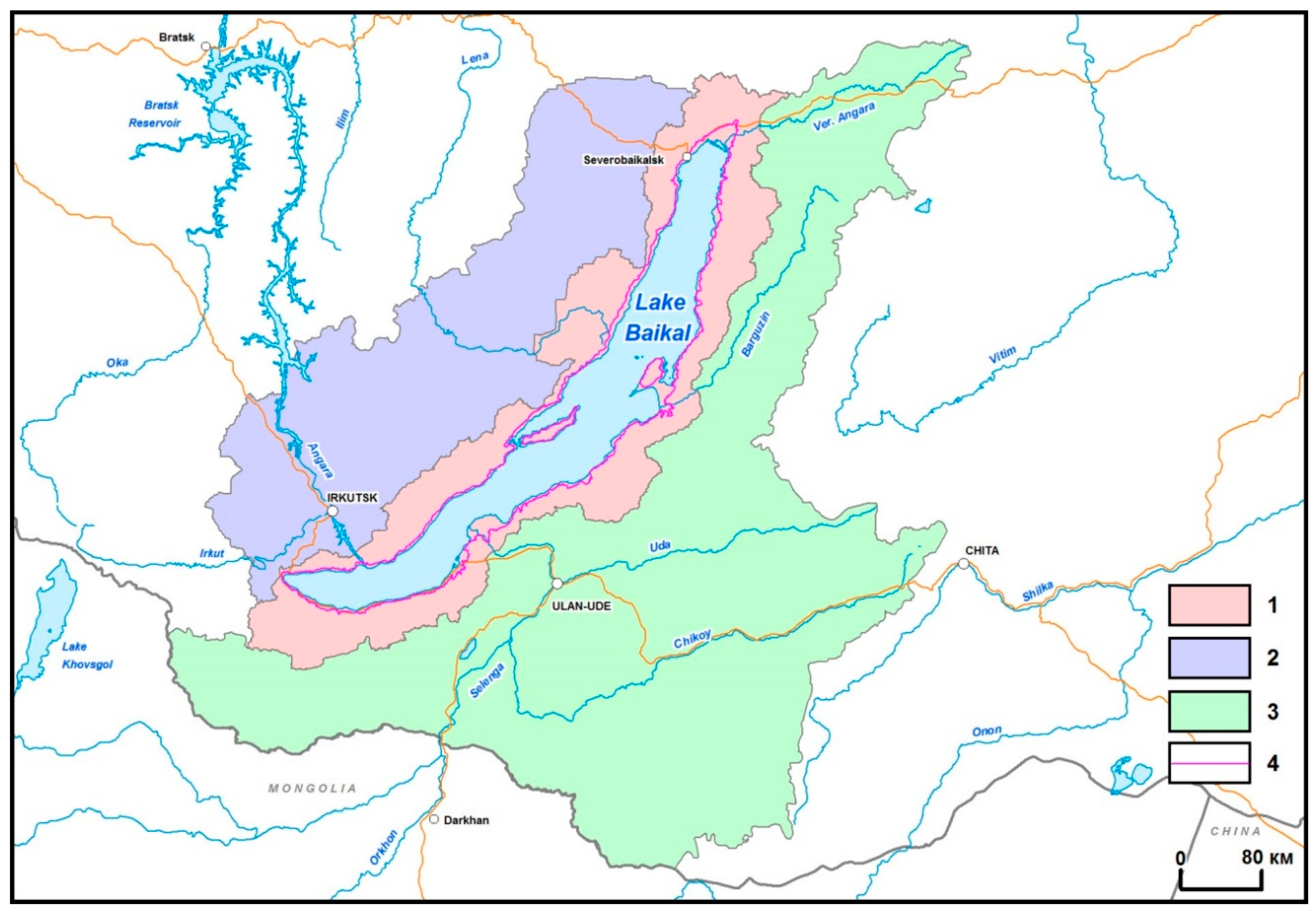
The Federal law “Concerning the protection of Lake Baikal” defines the list and composition of territories which are included in the ecological zone of the Baikal nature territory and securely protected lake area [
7]:
“Central ecological zone—a territory that includes Lake Baikal and its islands. This includes water protection zone of the lake, as well as protected areas surrounding the lake;
Buffer ecological zone—a territory beyond the central ecological zone that includes the catchment area of Lake Baikal within the territory of the Russian Federation;
Ecological zone of atmospheric influence—a territory beyond the Lake Baikal catchment area within the territory of the Russian Federation, which extends to a maximum of 200 m to the west and northwest of the lake and that includes industrial objects that negatively impact the unique ecological ecosystem of Baikal” (
Figure 1).
The Lake Baikal water protection zone boundary has crucial significance as it provides protection against pollution, clogging, silting of water objects, and depletion of water, as well as the preservation of the habitat area for water biological resources and other plant and animal life objects [
12].
The water code of Russia defines the precise sizes of external boundaries of water protection zones for all water objects in the Russian Federation: the width of rivers, lakes, and water reservoirs should be from 50 to 200 m depending on their length and coverage, and the width of seas should be 500 m. In Russian legislature, the status of Lake Baikal includes a clause on the definition of the Lake Baikal water protection zone boundaries. That clause is exceptional among norms for other water objects in the Russian Federation; the boundaries of the Lake Baikal water protection zone are defined in accordance with the Federal law “Concerning the protection of Lake Baikal” and have been approved by the Government of the Russian Federation [
7,
12].
One of the first subordinate acts to the Federal law “Concerning the protection of Lake Baikal” was the Russian governmental Decree # 643 of 30 August 2001 “On the approval of the list of activities prohibited in the central ecological zone of the Baikal nature territory”, which set limits for more than 50 activities [
13].
The boundaries of the central ecological zone were adopted in 2006 [
14], and the boundaries of the Lake Baikal protection zone were set in 2015 [
15]. The external boundaries of the central ecological zone and the Lake Baikal water protection zone almost coincide and thus, they sum up the legal regimes of both territories and impose additional restrictions on various activities in that territory.
On 26 March 2018, the Russian government adopted a resolution 507-p that significantly reduced the Lake Baikal water protection territory [
16]. However, the reasonableness of setting the lake’s water protection zone boundaries is still under discussion both at the expert level and within the scope of official instructions of the Russian government.
The justification and legitimacy of special ecological zone boundaries, as well as the consistency of the legal regime are necessary conditions of the socio-economic development of the central ecological zone of the Baikal nature territory, including the Lake Baikal water protection zone.
Economically effective use of nature in the Baikal region should not contradict the preservation of the lake’s ecosystem and water resources. The most popular types of ecology-based recreational nature use in the Baikal region are possible only in combination with the Lake Baikal protection tasks [
17]. This position has been widely declared since the end of the 1990s, but it does not find support in all public, business, and governmental groups, as the ecologically determined development of the territory contradicts the economic benefits of business and the public.
3. Main Ecological Problems
Industrial development on the Baikal shores started in the 1950–1960s and generated a negative cumulative effect on the ecosystem and water resources of the lake. Forest activities and agricultural development in the catchment area and the construction of hydropower cascades on the Angara River contributed to hydrological and hydrochemical regime changes in the lake and its tributaries. The construction of the Irkutsk hydropower station triggered a rise in the water level of 0.9 m on average and changes in the annual fluctuations of the level which resulted in the reshaping and flooding of low-lying shore parts and the formation of many coastal shallow lakes and estuary swamping, which became accumulation zones for catchment area pollutants and eutrophication centres affecting shallow water areas [
18,
19].
Transport development, mainly railway and automobile roads, as well as their infrastructure on the south and north shores, have had a considerable negative influence on the lake’s ecosystem by transforming the vegetation and soil cover and discharging hazardous substances. Considerable negative effects have been detected in industrial regions, such as the towns of Severo-Baikalsk, Babushkin, Baikalsk, and Slyudyanka. These effects are the result of industrial and domestic wastewater disposal, where wastewater treatment does not meet the norms of allowable discharge into Lake Baikal [
20].
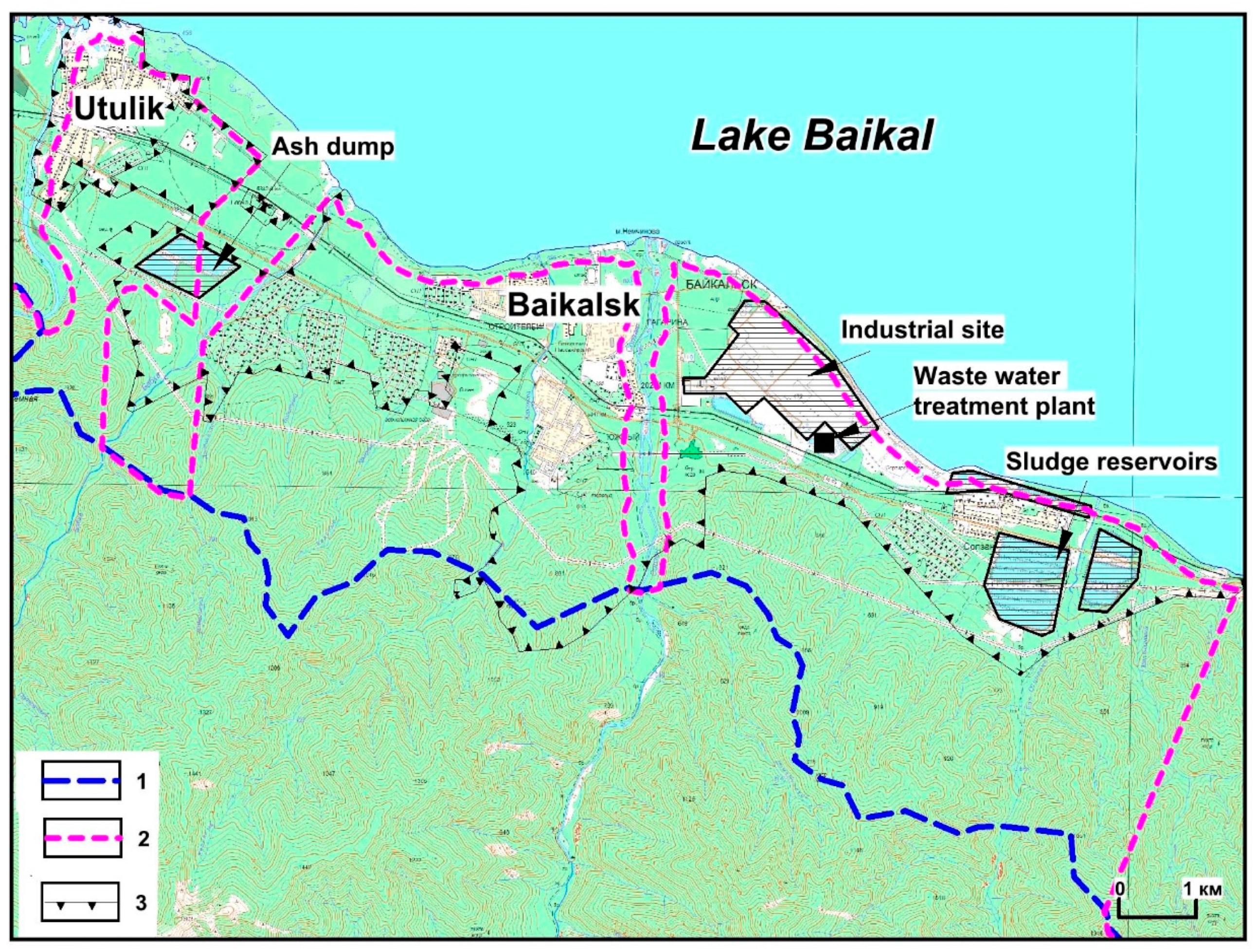
The Baikal pulp and paper plant, located on Baikal’s shore, started its production work in 1966 and discharged wastewater into the lake until 2013. Even after operational closure of the plant, production waste located in sludge collectors and settling tanks and polluted ground water coming from waste collectors and the industrial sites of the plant, still continued being one of the most considerable sources of the lake’s pollution. There are 6.2 million tonnes of production waste containing lignin, sulphates, iron, manganese, and other chemical components located on an area of 150 ha 1.5 km away from Lake Baikal’s shore. During the process of filtration and diffusive disposal, these components enter the lake with ground water [
20,
21].
Waste collectors on the shore are ecological risk factors for Baikal in cases where dangerous hydrological and geological-geomorphological processes occur. The lake’s shore is characterized by the potential for high seismicity, mudflows, and avalanches and these events present a serious threat to Baikal under conditions of considerable technogenic transformation of the environment [
22].
Currently the main threats to the ecosystem and water resources of the lake, as before, appear as a result of disposal of undertreated industrial and domestic wastewater, as well as the massive growth of recreation. Recreational pressure is mainly concentrated on the south shore, but this zone has been intensively extended in recent years. Lake Baikal tourist flow has grown by 5–10% every year and currently, there are 2.5 million visitors per year, and further increase of the tourist flow is expected to occur [
21]. The growth of recreational pressure has led to serious degradation of the shore and pollution of shallow aquatories. The lack of a centralized water supply and water disposal systems in the majority of recreational locations has resulted in pollution of the lake by unregistered waste discharges [
23]. Another very negative environmental impact comes from biogenic substances (nitrogen and phosphorus compound) through dispersed surface and groundwater disposal from small tourist objects and “wild” tourist camps [
20,
24].
The growth of biogenic element disposal has also been detected in the centralized waste water disposal system of waste treatment facilities and in the waters of tributaries with diffusive and dispersed disposal. Those elements are nitrates, nitrites, sulfates, chlorides, synthetic surface-active substances, and organic phosphorus. They all are indicators of household pollution which happens due to insufficient control of disposal norms and hygienic conditions at recreational and settlement territories on Lake Baikal’s shore. According to RosPrirodNadzor (Russian nature use supervision agency) data, all waste treatment facilities that deal with water disposal into the lake in Severo-Baikalsk, Babushkin, Baikalsk, Slyudyanka, and Vydrino, do not reach the norms of waste treatment. Bilge waters and shipping waste waters are not collected properly [
21,
22].
Considerable anthropogenic pressure on the Selenga river ecosystem within the Russian territory comes from transboundary pollutant transfer from Mongolia which indirectly influences Lake Baikal [
25,
26,
27]. A major concern is the hydropower construction projects in the Mongolian part of the Selenga river basin which will lead to changes in the hydrological, hydrochemical, and hydrobiological regimes of rivers and eventually, will influence the Lake Baikal ecosystem [
28].
The continuous low water level in 2012–2017 seriously contributed to the negative effects of the anthropogenic load on the lake and raised a critical question of whether it is necessary to tighten the control and decision making related to the protection of Lake Baikal’s water resources. The legal regulations of the UNESCO World Heritage site, protected areas, ecological zones of the Baikal nature territory, and the restrictions on economic activity in the central and water protection zones of the lake are ecological regulation instruments and aim to set environmental load norms and protect the lake’s ecosystem. The Baikal water protection zone should play the main role in resolving existing problems. This is possible provided that there is a science-based approach to its design and restriction measures are taken and controlled.
4. Landscape-Hydrological Justification of the Water Protection Zone
Scientific design of the water protection zone, based on physiographic and landscape-hydrological principles, is focused on the reduction of the anthropogenic load and the prevention of possible negative impacts on the lake through the realization of natural water protection and environment protection features of the shore landscapes. Conceptually, the water protection zone is a complex of landscapes with hydrological cycles and water ecological potential that directly border Baikal. The size and regime of the water protection zone allow the preservation of the natural quality of water coming into the lake through the self-purification features of the landscapes and compliance with restrictions on the types of nature use activity within the zone boundaries.
The diverse landscapes present around the lake include mountain dark coniferous and light coniferous forests on steep and smooth heel slopes, low steppe and low swamped nature complexes, flood plains and estuary parts of tributaries, and small-leaved groups of anthropogenically disturbed territories. The processes of mass and energy exchange in landscapes stipulate the transformation of atmospheric precipitations to surface and groundwater flow and the movement of moisture into the drainage water object. Landscape components, such as vegetation, soils, and the morphological and geological peculiarities of territories, govern the processes of slope runoff, filtration in subsurface horizons, water accumulation in micro- and macro-depressions, changes in evaporation, as well the whole structure of water balance in the nature complex. Conditions of self-purification in landscapes, the intensity of slope runoff, and accumulation and filtration processes may vary depending on the slope, forest cover, swampiness, and the structure of soil and sub-soil horizons [
8,
9].
The water protection zone includes landscapes characterized by optimal environment protection and self-purifying properties, i.e., maximum water-ecological potential. Such functions are common to dark coniferous forests on smooth slopes and plain surfaces and the meadow boggy groups of the shore and estuary parts. They lead to equally slowed runoff, regulated by accumulation and filtration processes, and purify water as it moves to the lake. Flood plains and meadow boggy shore landscapes are zones of contact for watersheds and reservoirs, as well as zones where surface, ground, and lake waters interact. These landscapes play the role of a filter for nature waters on the way to a water object [
29]. Here, it is important to mention a role of the Selenga river delta which is as a natural filter of almost half of Lake Baikal’s water inflow, which protects the lake from pollution [
30].
However, there is a possibility here for secondary pollution products that have been previously accumulated in landscapes to get into the lake. This may happen after the disturbance of the natural soil vegetation cover and sub-surface layers, and it must be a restrictive condition in the economic development of a territory. Such landscapes form a frame around the water protection zone and require preservation of their natural conditions when planning any economic activities [
31].
It is reasonable to include territorial parts that are characterized by high exogenous activity and their potential negative impacts on the water reservoir in the water protection zone. These parts include the steep mountain slopes of the shore where this is the potential for extreme hydrological and geomorphological processes to occur, followed by the entry of fragmentary material and pollution substances into Lake Baikal (
Figure 2).
The size of the water protection zone in non-wooded territories is differentiated depending on the surface slope and soil and sub-surface filter characteristics [
32,
33]. The boundaries of the water protection zone in the plain and smooth slope parts of the shore is marked by a relief edge with consideration of the direction of surface slope runoff or by outlining the waterlogged land. In accordance with the conditions of filtration and entry of surface waters into the lake, all lands submerged due to the rise in water level of Lake Baikal are included in the water protection zone.
Since the main function of the water protection zone is preservation of the natural quality of water entering into Lake Baikal and prevention of possible negative impacts, the following points were set as the main criteria for defining the lake’s water protection zone [
31]:
The water protection zone covers a territory where water flows are drained directly into Lake Baikal; pollutants beyond the set water protection zone are drained by water flows and do not enter directly into the lake.
The water protection zone boundary coincides with the watershed line that is closest to the lake; under conditions of a remote watershed line and the existence of plain shore territories (up to 3°–7°), the boundary is marked by the outline of landscapes with high water protection potential stipulated by the optimal combination of their structural components.
The water protection zone includes the basins of minor elementary water flows of major order. The water protection zone boundary for the larger tributaries of Lake Baikal is marked by the narrowest parts of the river valleys at the points of intersection with the shore ranges.
The expansion of water protection zone boundary beyond the limits of the first watershed line considers the high probability of mudfloods and considerable activity of dangerous exogenous processes (avalanche, taluses, block shifts, etc.) on the territory of direct influence on Lake Baikal.
The shore territories of Lake Baikal that are under economic development, including residential areas, should have water protection zoning with differentiation of actions for pollution prevention and minimization of negative anthropogenic impacts on the lake’s ecosystem, with consideration of opportunities for economic development of the territories. The zoning of urbanized territories must be based on nature conditions, as well as the peculiarities of residential, engineering, transport, and communal infrastructures [
34].
Questions related to the protection of the lake’s water resources in residential areas as well as recreational zones require detailed elaboration; this has been mentioned a number of times since the adoption of the law “Concerning the protection of Lake Baikal” [
7]. The residential areas located on the shore territory of Lake Baikal or at a short distance from it are the most polluted areas and have a considerable negative impact on the lake.
The lake’s water protection zone project includes the elaboration of functional water protection zoning of residential and recreational territories based on the contemporary and perspective conditions of planning and construction with the purpose of minimizing pollutant flow.
Nature protection actions in residential areas are oriented mainly towards technological schemes of waste treatment and the standardization of water economic activity, without consideration of the capabilities of self-purification features of the territory. Based on the natural conditions of the territory and level of its anthropogenic disturbance, it is possible to project a system of economic activity restrictions on certain territories to preserve the quality of surface and ground waters coming into Lake Baikal and to reduce dangerous hydrological-geomorphological processes.
According to landscape-hydrological principles, the main indicators of pollutant flow from economically active areas are the condition of the soil vegetation cover and the water-bearing layer of rocks and ground. Landscape hydrological analysis allows the identification of the water-ecological potential of water protection zone landscapes, i.e., the resistance of hydrological functions of landscapes to natural and anthropogenic changes [
35].
The main tasks of assessment of urbanized area potential are
The identification of anthropogenic load sources and their levels of impact on the surface and ground water quality during the period of economic activity in the area.
The assessment of the level of ground water protection from pollution based on an analysis of the filtration and sorption capacity of the soil and ground composition in the aeration zone.
The identification of hydraulic connections between the river, lake, and ground waters, and the assessment of sub-surface flow into Lake Baikal.
The characteristics of the intensity of dangerous hydrological-geomorphological (erosion and mud flow) processes in the territory.
The project of environmentally-determined development of Baikalsk town and its suburb zones implemented in 2002 can serve as an example of water protection zoning of Baikal shore urbanized territory with high exogenous activity [
36].
The combination of landscape hydrological principles of territory assessment and methods of target landscape design enables functional zoning with the imposition of restrictions within the zone boundaries in order to prevent pollutant flow into Lake Baikal and to minimize negative anthropogenic impacts on the lake’s ecosystem in places of concentration of industrial, residential, and recreational objects [
37].
Functional water protection zoning may be considered the most optimal instrument for the justification of protected territory development without damage to nature shore waters and Lake Baikal.
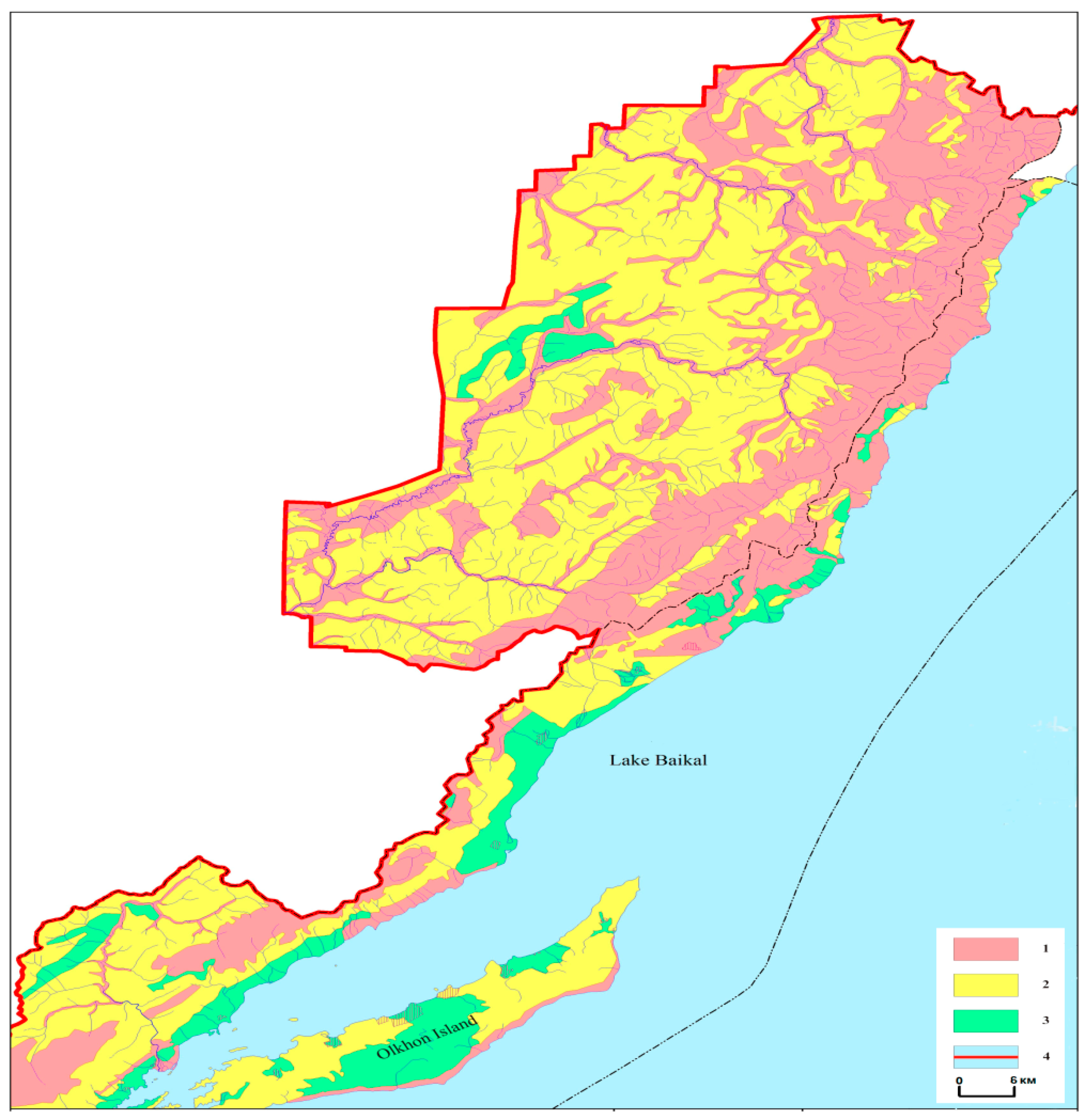
For the purpose of recreational development on the south shore of Lake Baikal, a framework for functional water protection zoning of a part of the central ecological zone, including the water protection zone of the lake, was done. According to the landscape-hydrological conditions of the territory and method of landscape design, there are at least three levels of nature use: preservation of the current condition, regulated use, and free economic development [
38]. Such zoning, which considers the peculiarities of the formation, regulation, and transformation of nature waters as they flow into the lake, enables the identification of opportunities for shore zone development without damage to the lake’s ecosystem. Science and ecology-based zoning projects for residential and recreational areas are the best option for supporting the economic development of the shore territory that also consider the nature conditions and protection of the unique lake (
Figure 3).
Unlike the common regulation of activity in the water protection zone, the recommended zoning determines different levels of nature protection activity for administrative bodies and economic entities which use the territory.
It is worth noting that there is considerable international experience with water resource protection both for World Heritage sites and other unique nature objects, such as the American Great Lakes, Lake Boden, Lake Geneva, etc. There is a complex of normative and interstate acts in Canada and USA, which have been issued to cover the problems of institutional, economic, and scientific support “for the purposes of development of the Great Lakes regional cooperation” [
39].
For more than 50 years, the Boden Lake basin has been a region of active international cooperation and special regulation of ecological problems between Germany, Austria, and Switzerland. The task of water object preservation has been solved by different methods, most often by the restriction of economic activity on a shore line of a fixed width which could legally work for Russian water objects. The size and configuration of the Lake Baikal water protection zone depends upon the landscape characteristics of the shore territory and the secure natural purification of waters as they move into Lake Baikal; therefore, Lake Baikal’s natural water protection zone can serve as a non-traditional approach to the problem solution.
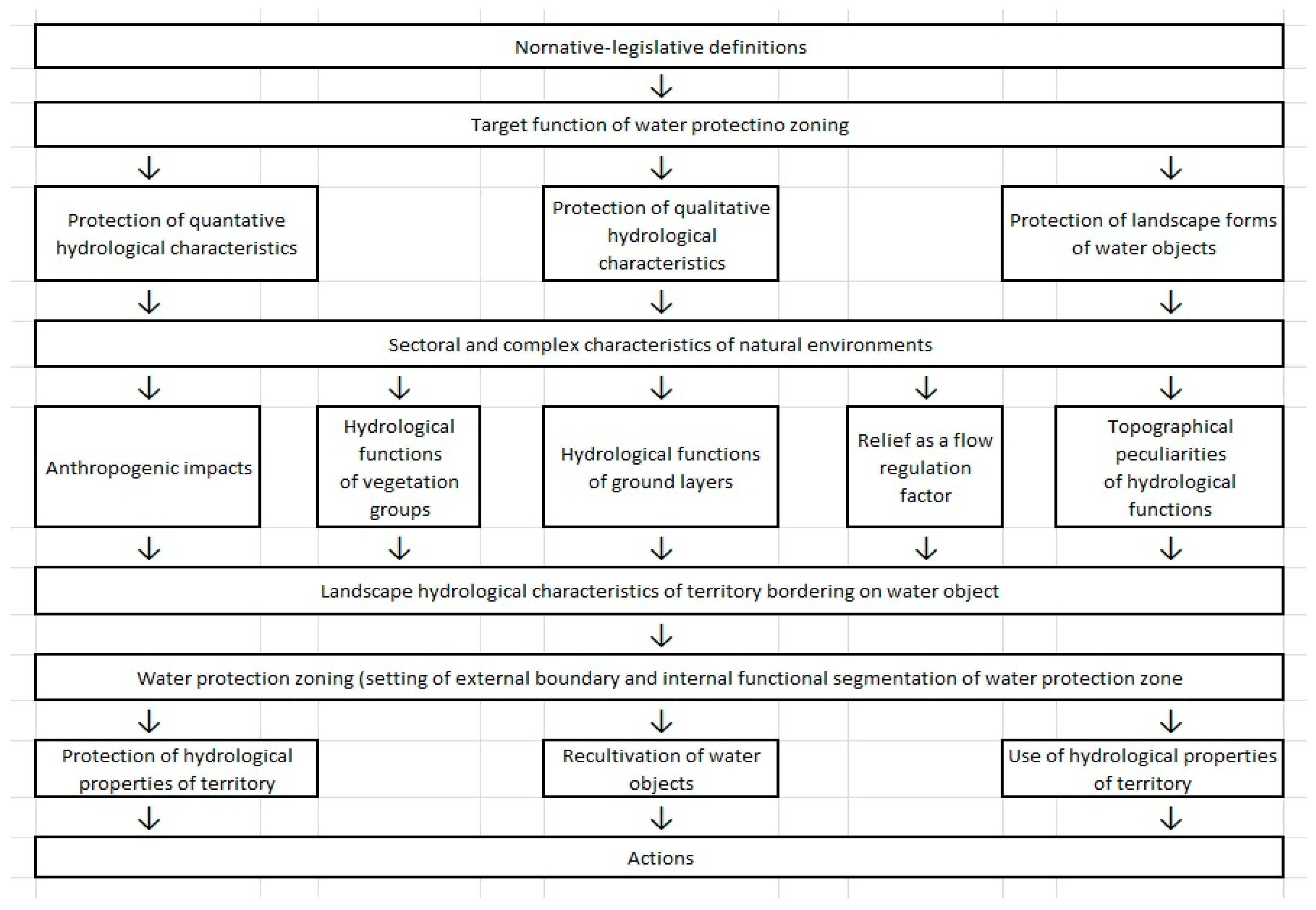
The landscape-hydrological approach to the identification of the water protection zone width is based on the analysis and assessment of the water protection capabilities of the landscape components, which secure the transformation of natural waters, including pollutants, as they move into the water object. The multistage scheme of analysis includes the characteristics and correlations between different parameters of vegetation, soils, and grounds, as well as the study of hydrogeological indicators, slopes, and surface exposure, etc. (
Figure 4).
5. Conclusions and Proposals
The result of this work was the creation of a natural water protection zone for Lake Baikal; its boundaries (excluding settlement territories) were approved by Government of the Russian Federation in 2018 [
16].
The water protection zone of a water object is an element of the management and protection of water resources in the system of sustainable nature use. The functional water protection zoning based on landscape-hydrological approach determines the possibility for economic development with the current water resource and water ecological characteristics. The target function of the science-based water protection zone of Lake Baikal is not only a regulation on anthropogenic impacts, but also provides coordination and control for all types of activities associated with the use and protection of the water object.
The elaboration of territory development schemes, further realization of actions on preservation, and improvement of the ecological condition of the lake require up-to-date information on the condition of the environment and economically active objects on the shore areas of the lake. Ecological monitoring, which includes not only traditional methods, but also emergency forecasts and the control of sanitary and hygienic condition, serves as the most important mechanism for the prevention of ecosystem threats to Lake Baikal. Standard observations in the water protection and central ecological zones should be complemented by special programs, considering the specifics of the unique monitoring object.
The development and implementation of the following monitoring types within the water protection zone take priority in the prevention of threats to the Lake Baikal ecosystem: the shore zone of Lake Baikal; the protected areas located within the water protection zone; the condition of forests in technogenic pollution zones and the monitoring of phytodiversity; the sanitary and epidemiological conditions of the shore zone; the activity of large fault zones; and the presence of dangerous exogenous geological processes.
The most important task is the creation and support of a complex analysis system of the cause-effect relationships of data as a result of all types of monitoring of the Lake Baikal ecosystem’s condition. Such a system must unite the efforts of all agencies (more than 10) [
40], be provided with up-to-date equipment and an observation system, and supported by highly qualified specialists. The universal world value of Lake Baikal was recognized by the UNESCO World Heritage Committee as an “outstanding fresh water ecosystem. Baikal is the oldest and deepest lake in the world. It contains 20% of the world’s total unfrozen freshwater reserve. The lake has produced one of the world’s richest and most unusual freshwater faunas, which is of exceptional value to evolutionary science. It is surrounded by a system of protected areas, which are of special value due to their beauty and natural qualities” [
6]. The unique qualities of Lake Baikal and its value for the world’s community stipulate open information sharing with the public and organizations regarding the condition of the lake’s ecosystem. Access to international expert evaluation of all objects located on the territory of the World Heritage site “Lake Baikal”, especially the water protection zone, and to all projects dealing with changes in the shore landscapes could become a practical instrument for the prevention of threats to the universal world value of Baikal.


