
Intercomparisons and Evaluations of Satellite-Derived Arctic Sea Ice Thickness Products

Abstract
:1. Introduction
2. Data and Method
2.1. Satellite-Derived SIT Products
2.1.1. ICESat-2
2.1.2. CryoSat-2
2.1.3. CS2SMOS
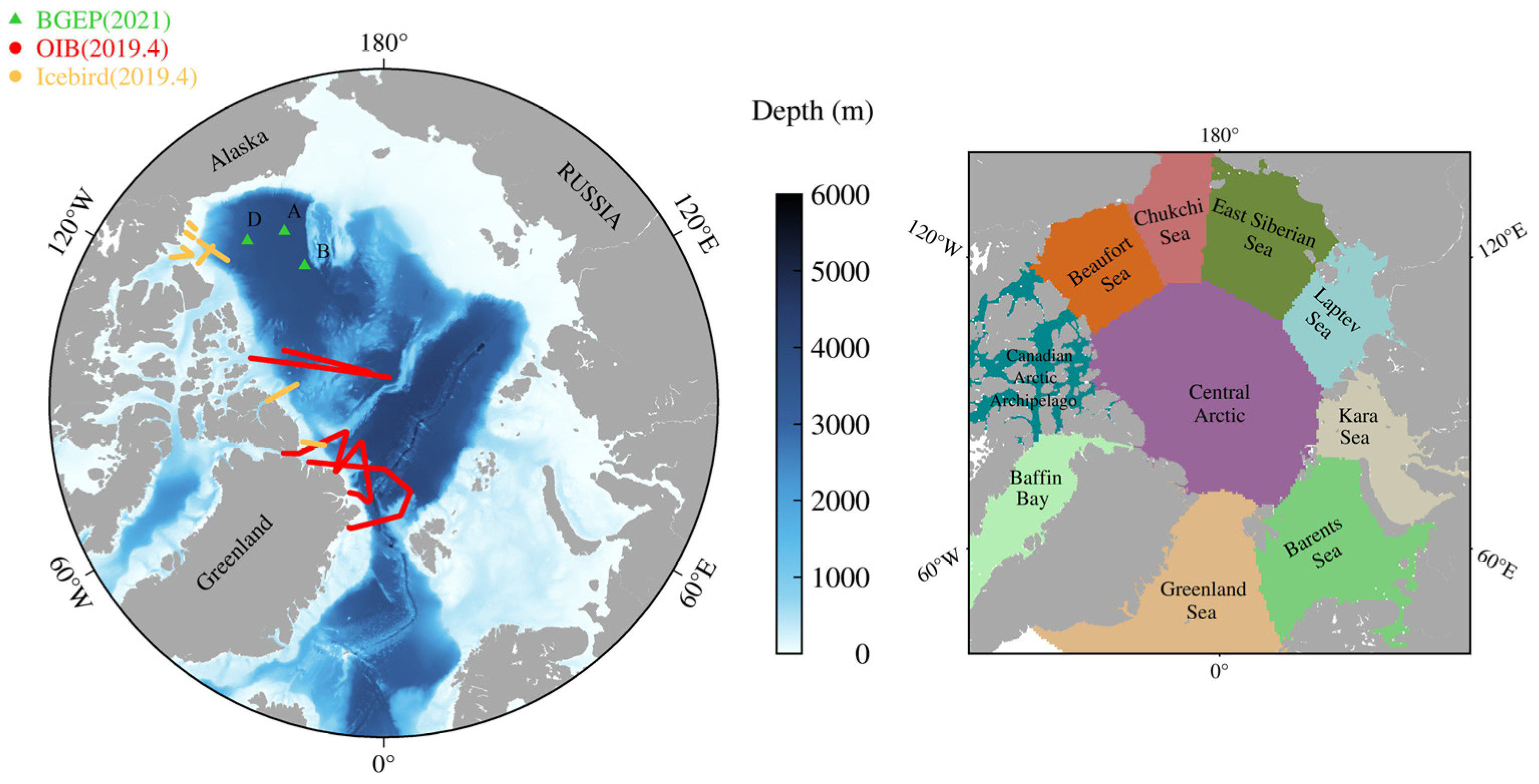
2.2. Evaluation Data
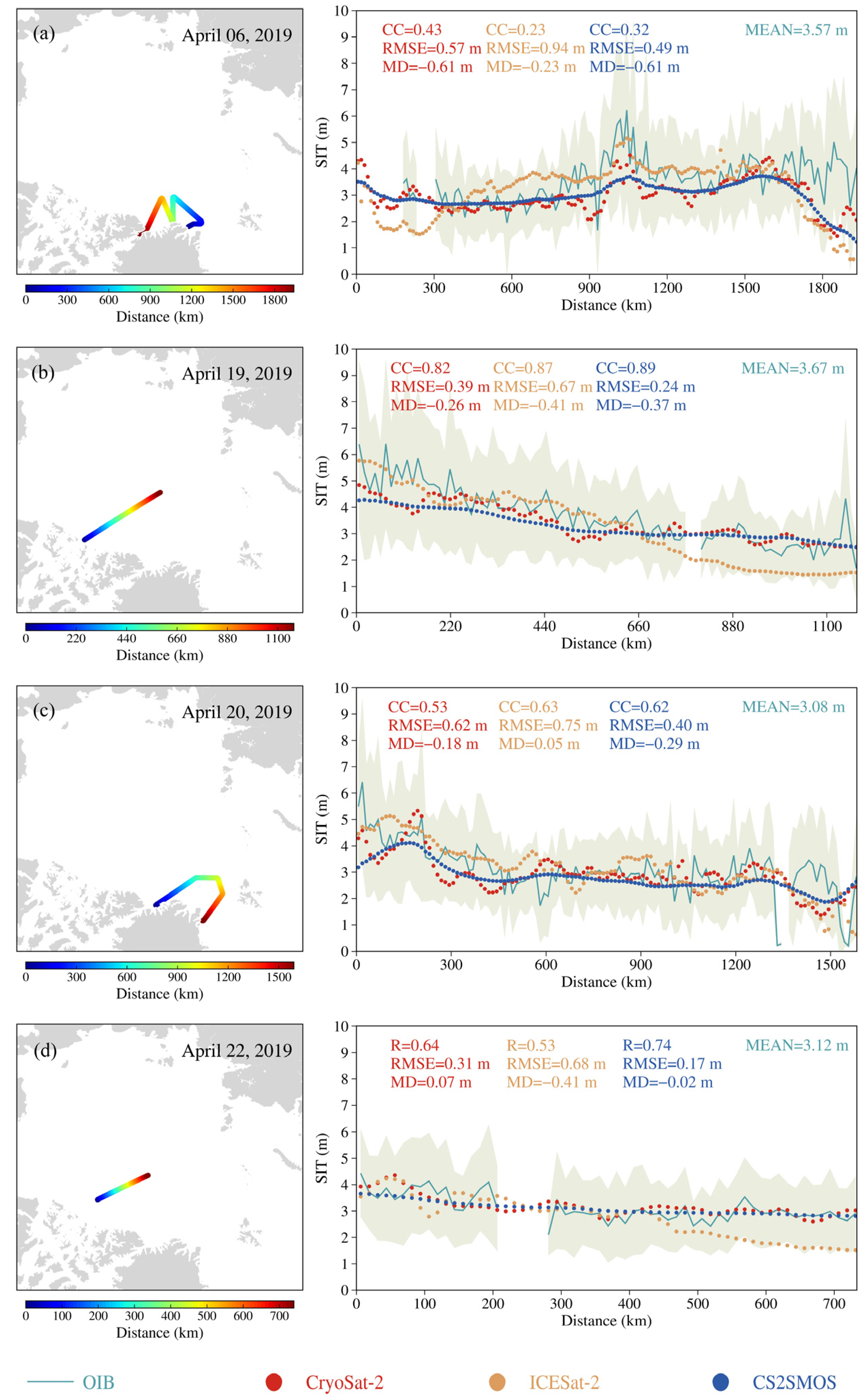
2.2.1. OIB
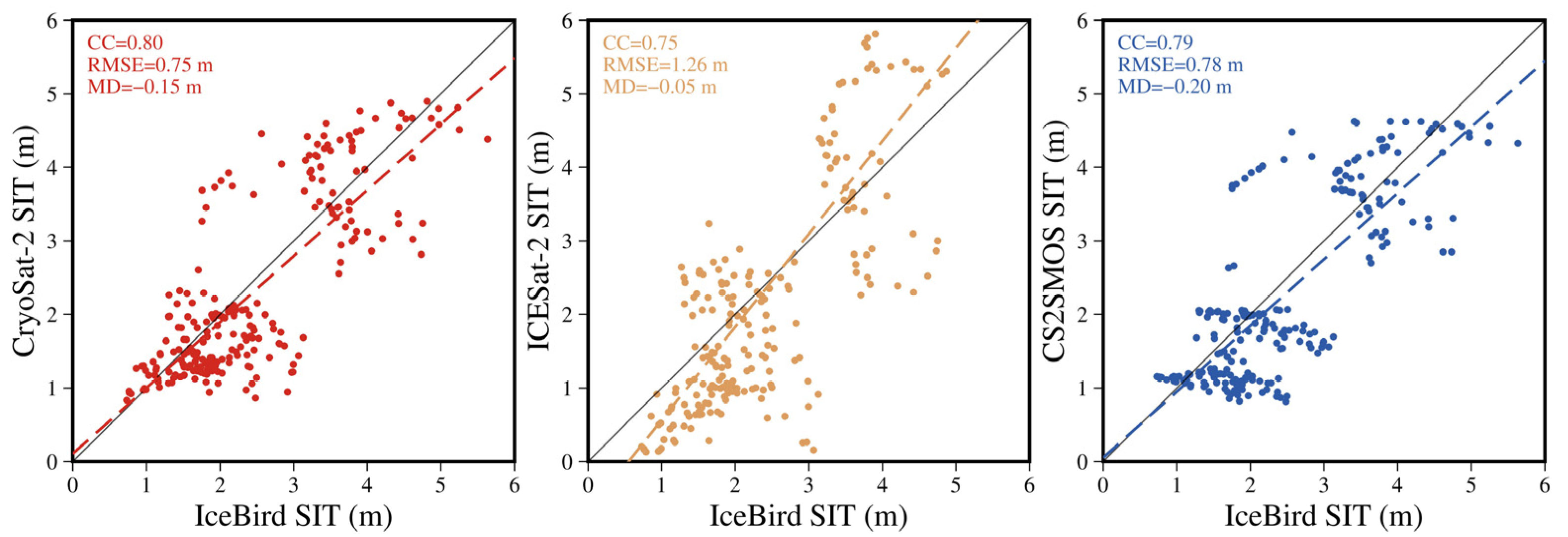
2.2.2. AWI IceBird
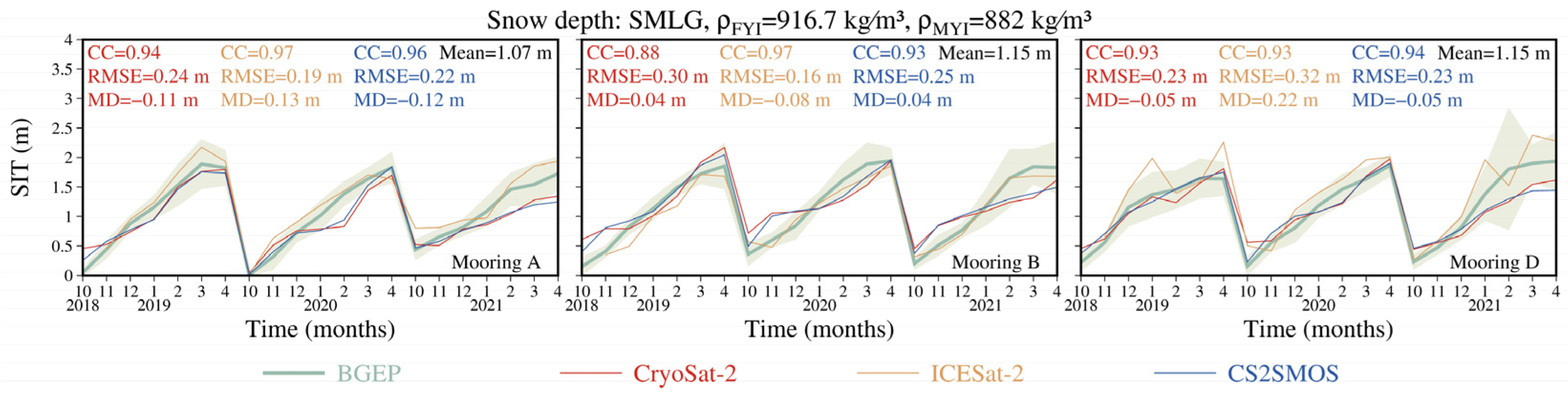
2.2.3. Beaufort Gyre Exploration Project
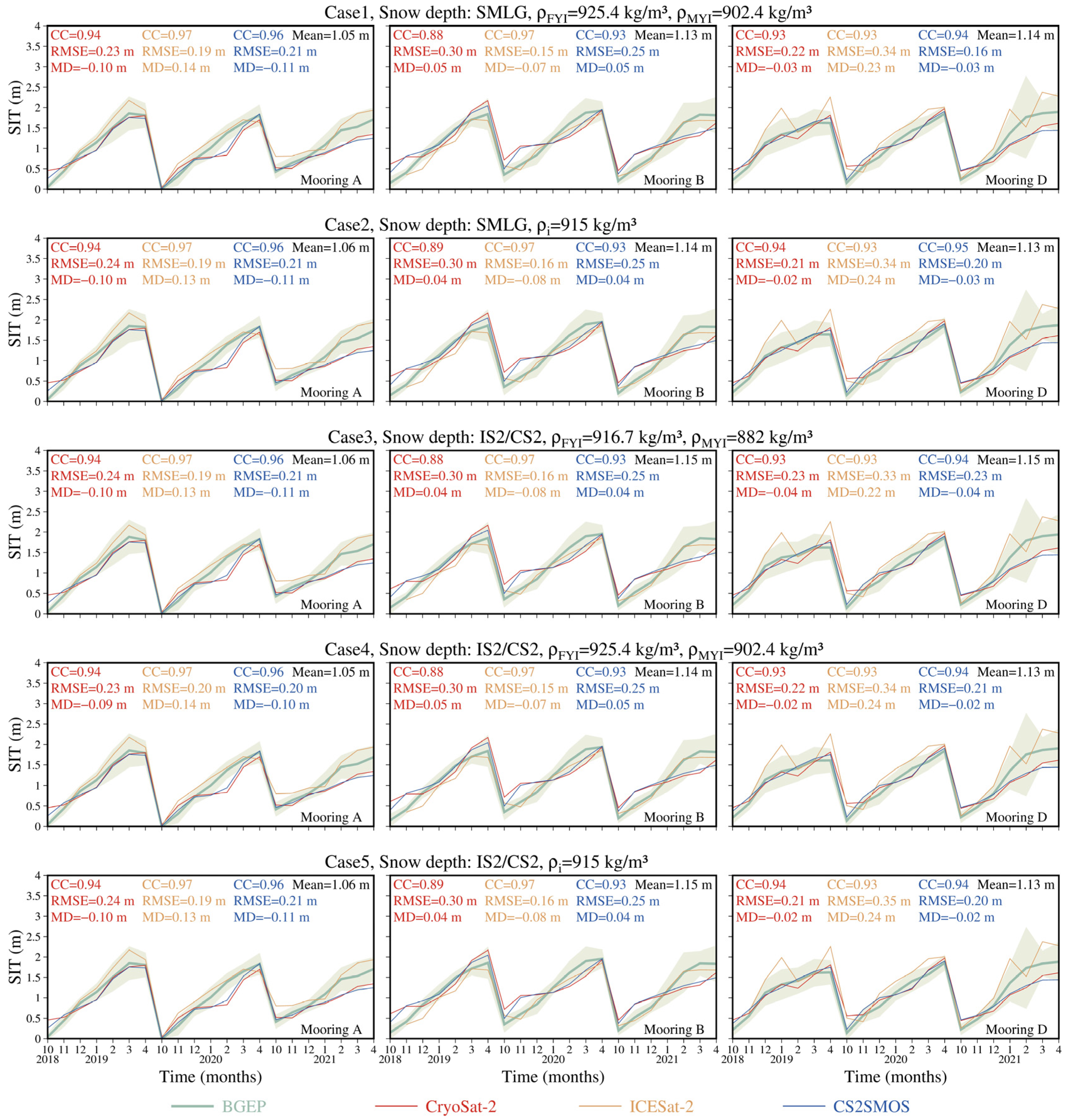
2.3. Sensitivity Cases of SIT Retrieval
2.4. Satellite Products Intercomparisons
2.5. Satellite Products Evaluations
3. Results
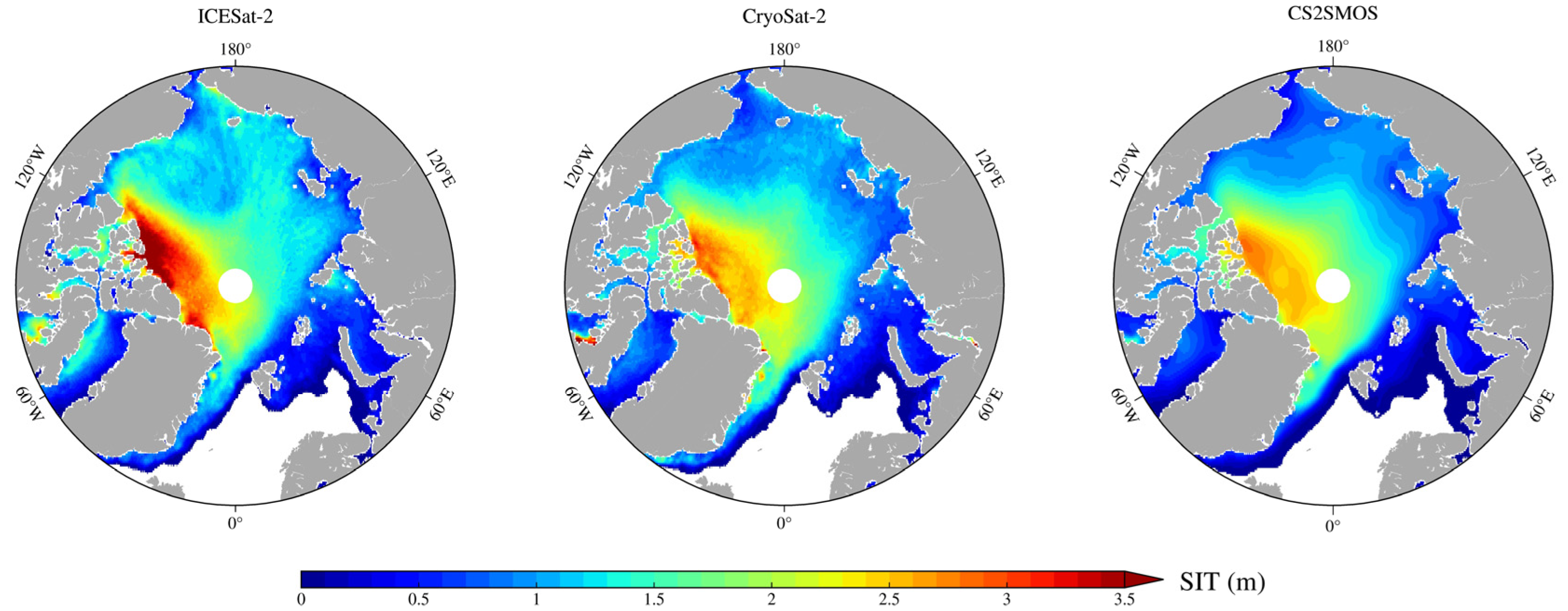
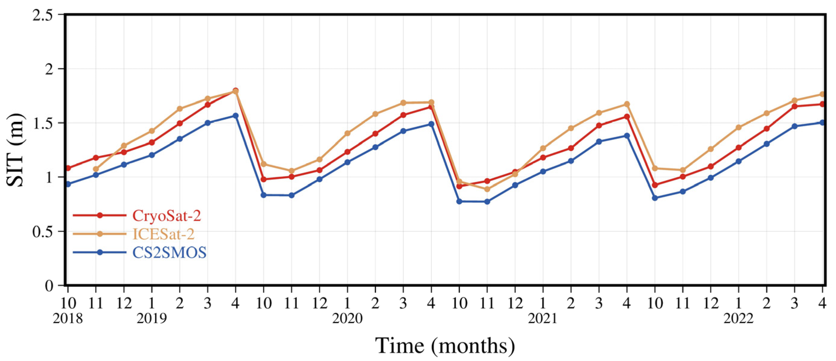
3.1. Intercomparisons of Satellite Products
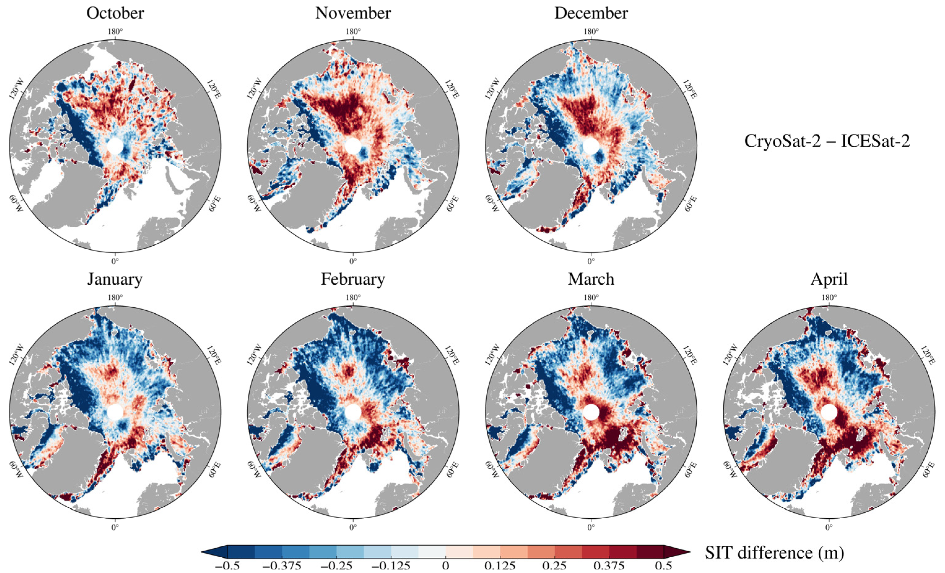
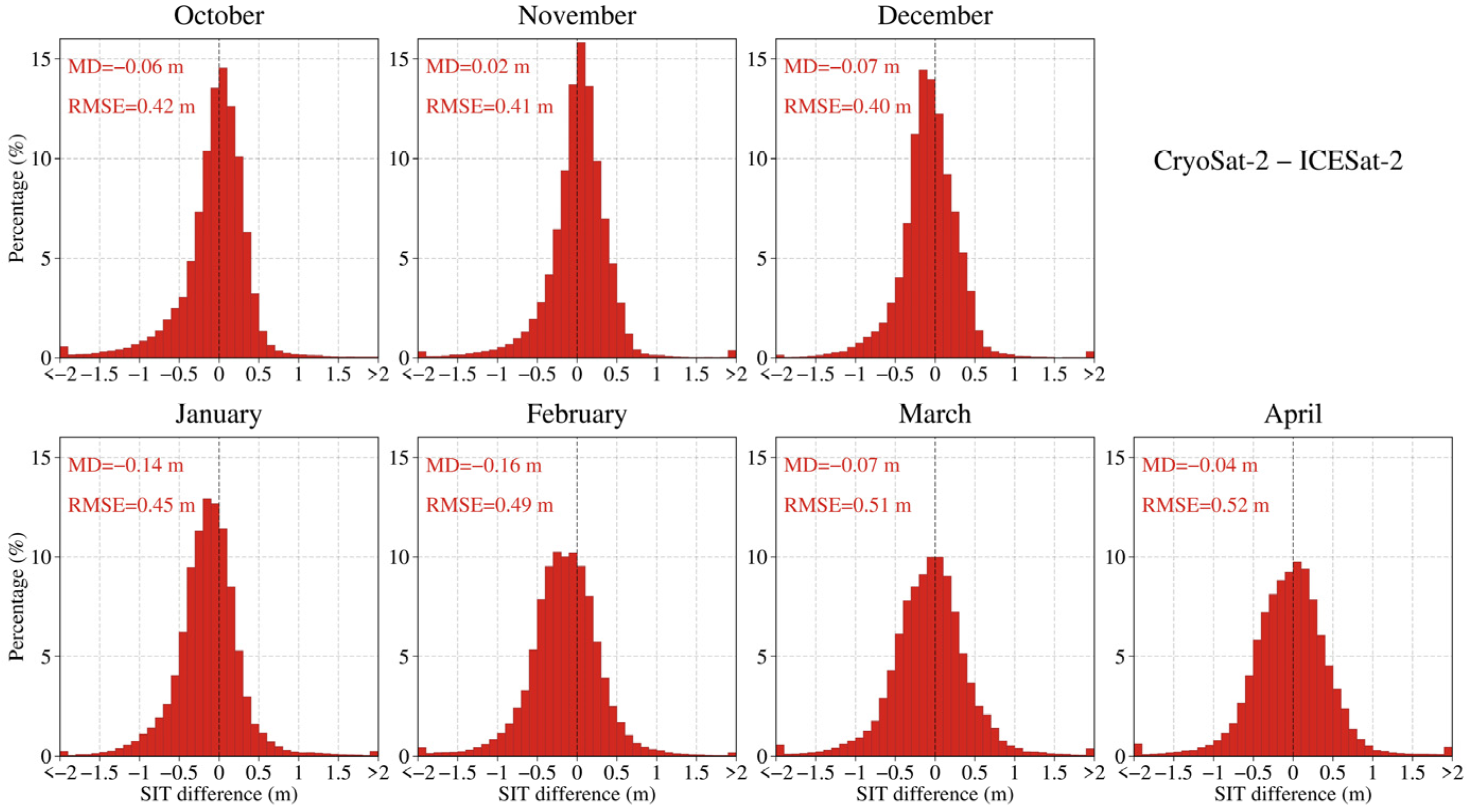
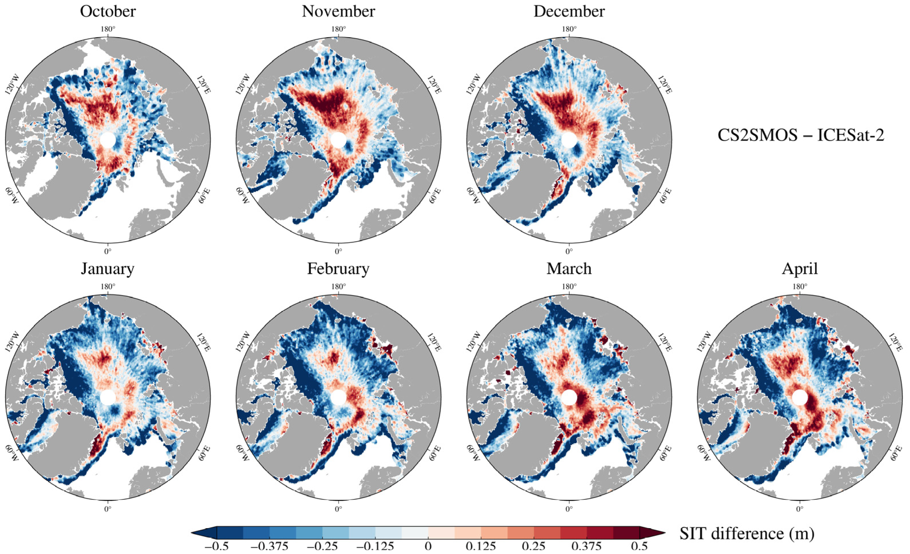
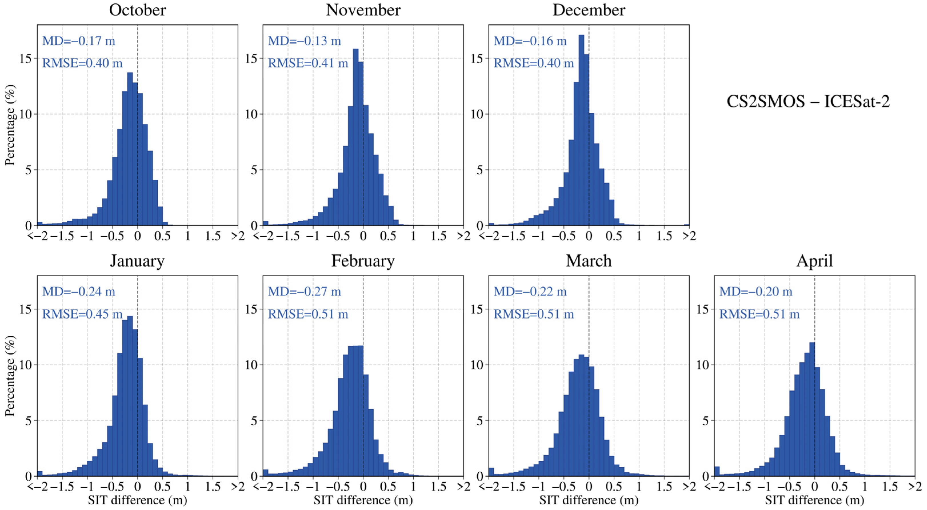
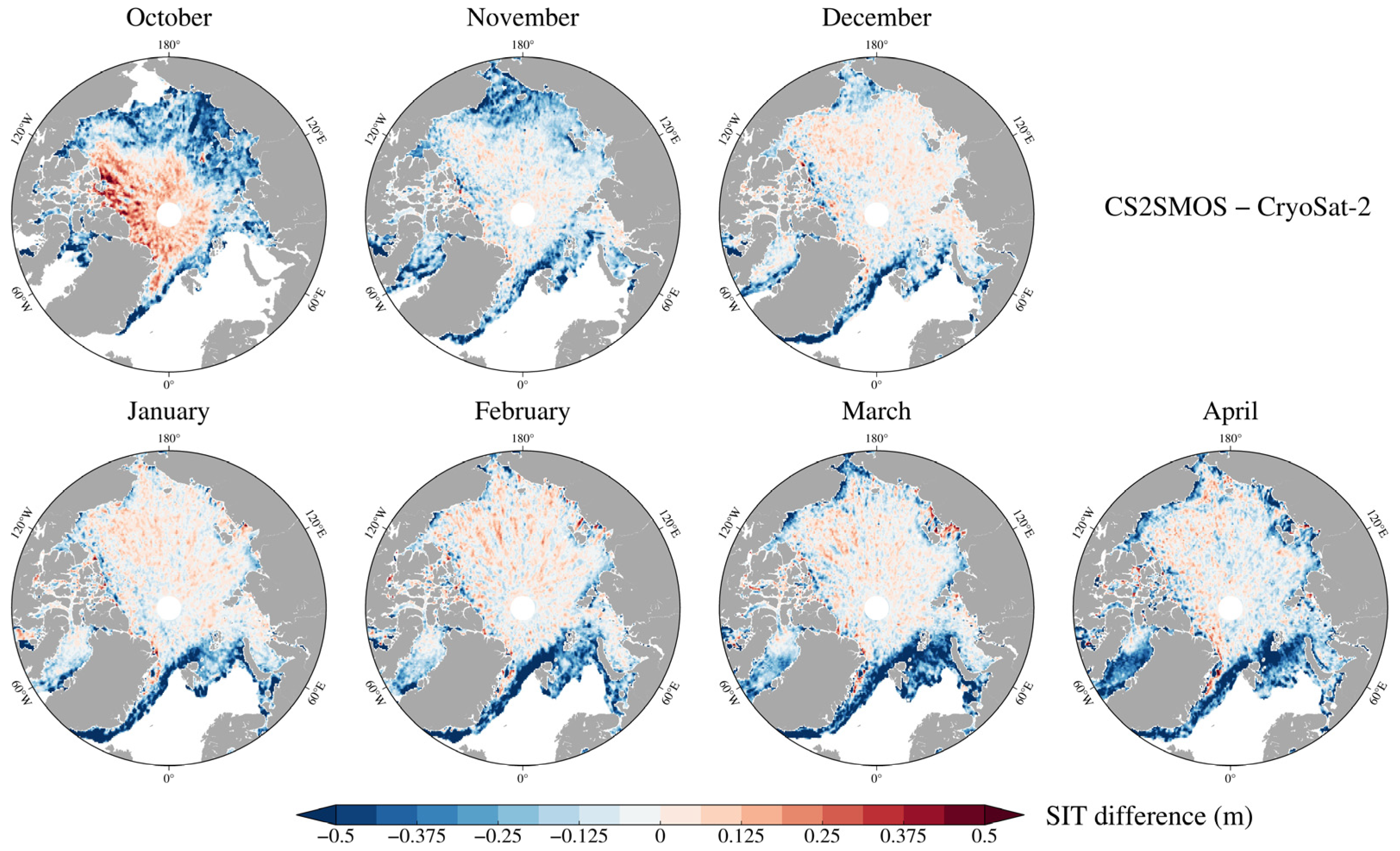
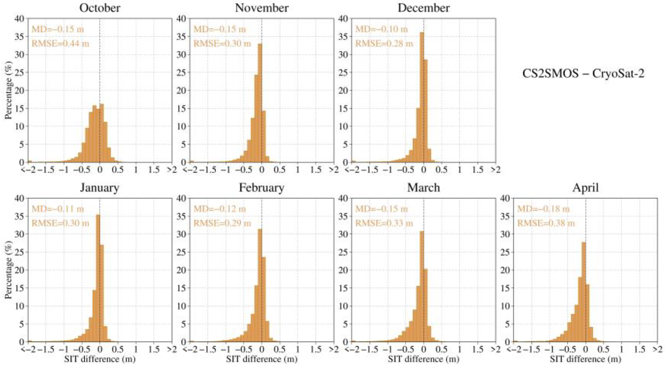
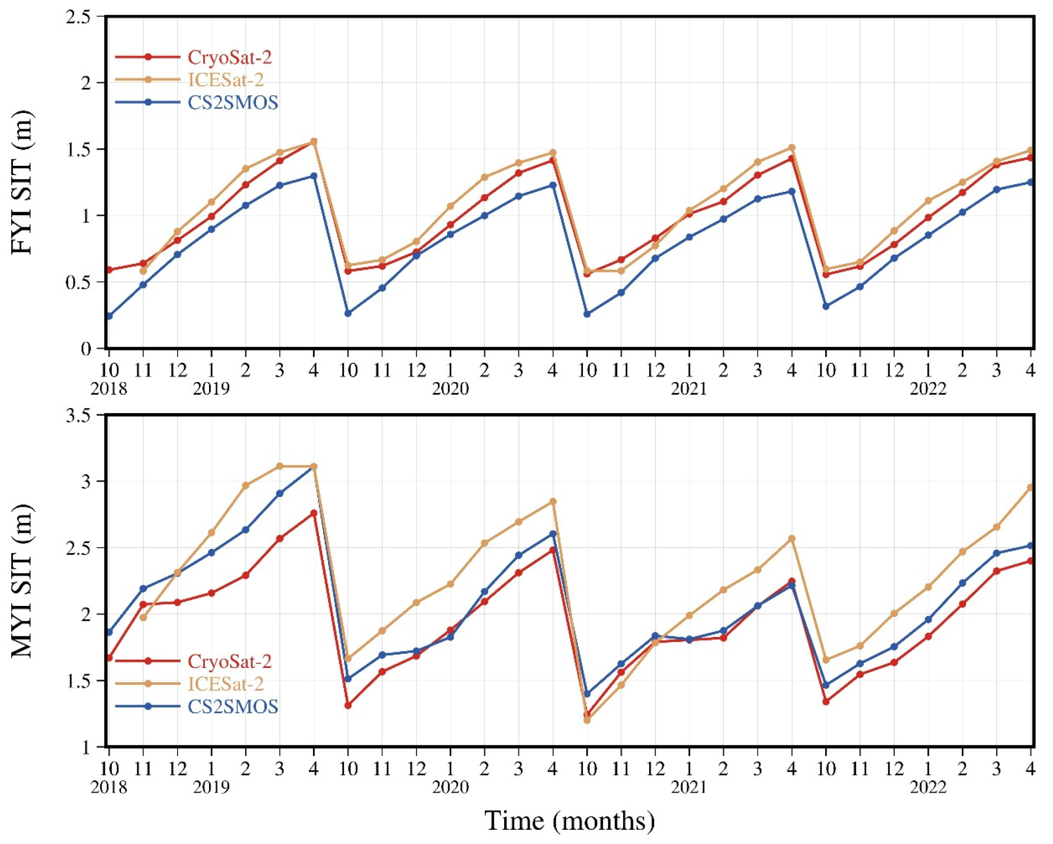
3.1.1. Spatiotemporal SIT Differences of Three Satellite Products
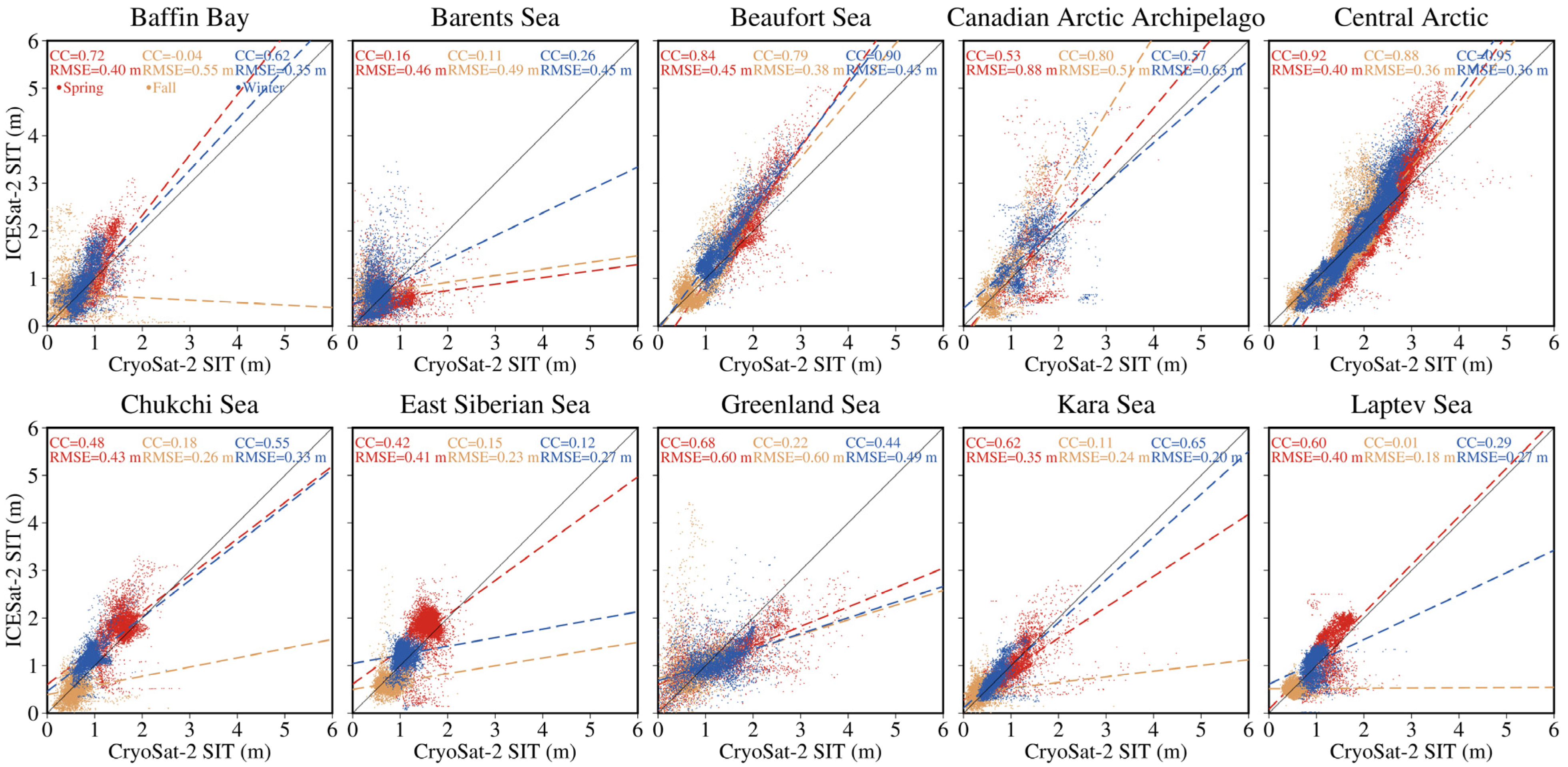
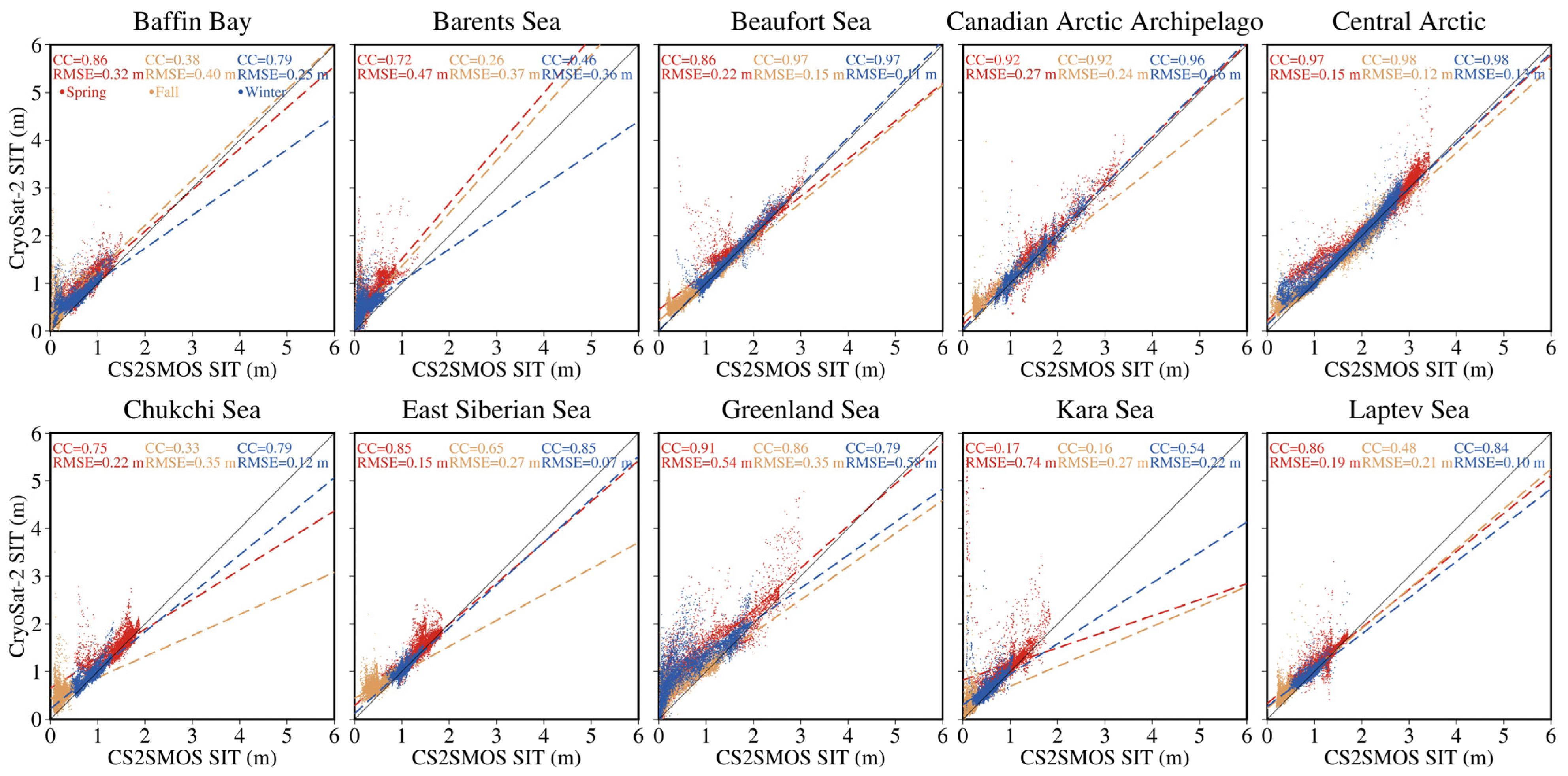
3.1.2. Pairwise Comparison of Satellite Products
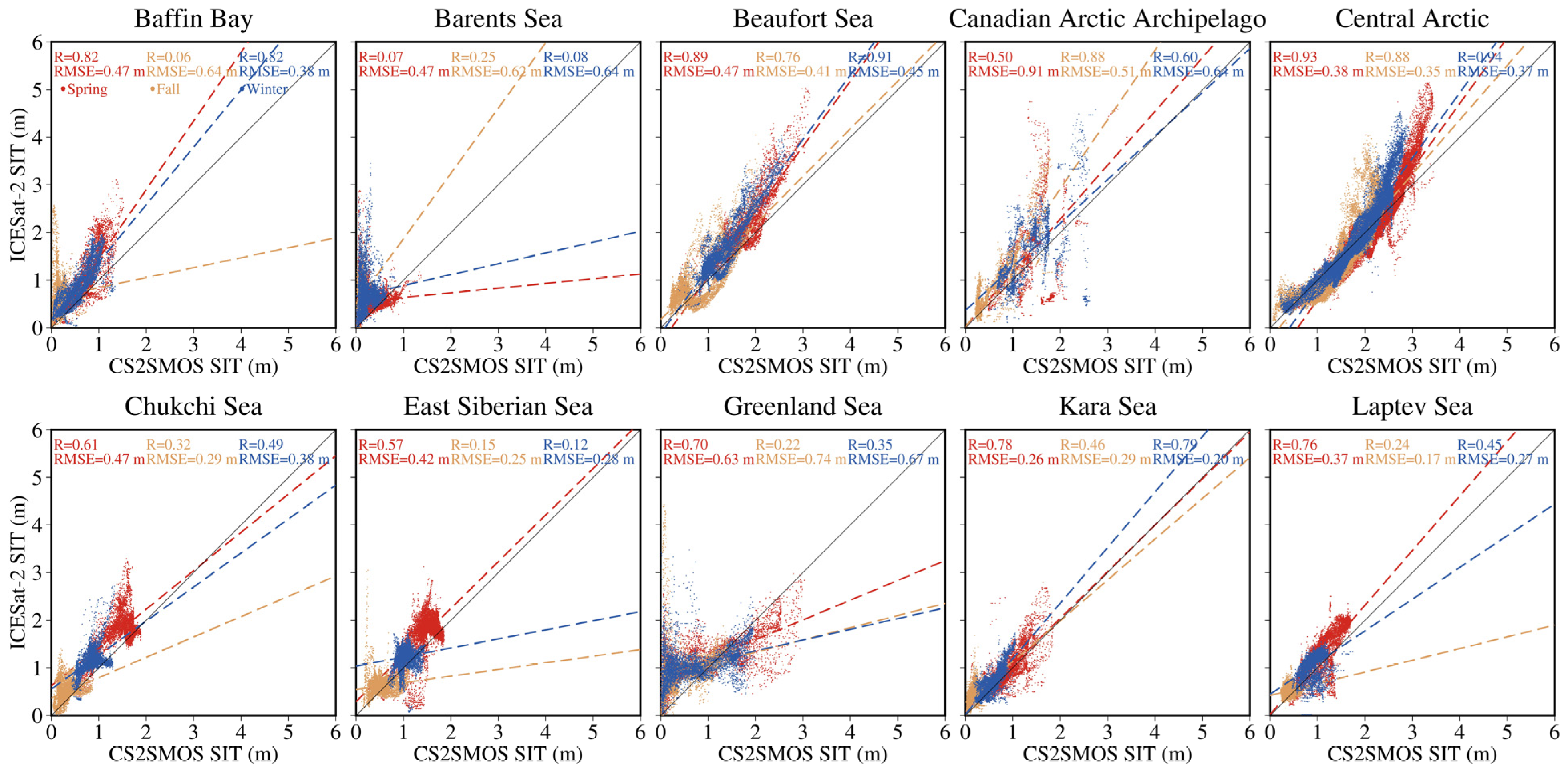
3.2. Evaluations of Satellite Products
4. Discussion
5. Conclusions
Author Contributions
Funding
Data Availability Statement
Acknowledgments
Conflicts of Interest
References
- Budikova, D. Role of Arctic Sea Ice in Global Atmospheric Circulation: A Review. Glob. Planet. Chang. 2009, 68, 149–163. [Google Scholar] [CrossRef]
- Guemas, V.; Blanchard-Wrigglesworth, E.; Chevallier, M.; Day, J.J.; Déqué, M.; Doblas-Reyes, F.J.; Fučkar, N.S.; Germe, A.; Hawkins, E.; Keeley, S.; et al. A Review on Arctic Sea-ice Predictability and Prediction on Seasonal to Decadal Time-scales. Q. J. R. Meteorol. Soc. 2016, 142, 546–561. [Google Scholar] [CrossRef]
- Mallett, R.D.C.; Lawrence, I.R.; Stroeve, J.C.; Landy, J.C.; Tsamados, M. Brief Communication: Conventional Assumptions Involving the Speed of Radar Waves in Snow Introduce Systematic Underestimates to Sea Ice Thickness and Seasonal Growth Rate Estimates. Cryosphere 2020, 14, 251–260. [Google Scholar] [CrossRef]
- Zhang, Y.; Chen, C.; Shen, X.; Xu, D.; Shao, W.; Beardsley, R.C.; Chang, L.; Feng, G. Role of Sea Level Pressure in Variations of the Canadian Arctic Archipelago Throughflow. Adv. Clim. Chang. Res. 2021, 12, 539–552. [Google Scholar] [CrossRef]
- Carmack, E.C.; Yamamoto-Kawai, M.; Haine, T.W.N.; Bacon, S.; Bluhm, B.A.; Lique, C.; Melling, H.; Polyakov, I.V.; Straneo, F.; Timmermans, M.-L.; et al. Freshwater and Its Role in the Arctic Marine System: Sources, Disposition, Storage, Export, and Physical and Biogeochemical Consequences in the Arctic and Global Oceans. J. Geophys. Res. Biogeosci. 2016, 121, 675–717. [Google Scholar] [CrossRef]
- Zhang, Y.; Chen, C.; Beardsley, R.C.; Gao, G.; Lai, Z.; Curry, B.; Lee, C.M.; Lin, H.; Qi, J.; Xu, Q. Studies of the Canadian Arctic Archipelago Water Transport and Its Relationship to Basin-local Forcings: Results from AO-FVCOM. J. Geophys. Res. Ocean. 2016, 121, 4392–4415. [Google Scholar] [CrossRef]
- Onarheim, I.H.; Eldevik, T.; Smedsrud, L.H.; Stroeve, J.C. Seasonal and Regional Manifestation of Arctic Sea Ice Loss. J. Clim. 2018, 31, 4917–4932. [Google Scholar] [CrossRef]
- Stroeve, J.C.; Kattsov, V.; Barrett, A.; Serreze, M.; Pavlova, T.; Holland, M.; Meier, W.N. Trends in Arctic Sea Ice Extent from CMIP5, CMIP3 and Observations. Geophys. Res. Lett. 2012, 39, 2012GL052676. [Google Scholar] [CrossRef]
- Kwok, R. Arctic Sea Ice Thickness, Volume, and Multiyear Ice Coverage: Losses and Coupled Variability (1958–2018). Environ. Res. Lett. 2018, 13, 105005. [Google Scholar] [CrossRef]
- Olason, E.; Notz, D. Drivers of Variability in A Rctic Sea-ice Drift Speed. J. Geophys. Res. Ocean. 2014, 119, 5755–5775. [Google Scholar] [CrossRef]
- Wang, K.; Zhang, Y.; Chen, C.; Song, S.; Chen, Y. Impacts of Arctic Sea Fog on the Change of Route Planning and Navigational Efficiency in the Northeast Passage during the First Two Decades of the 21st Century. J. Mar. Sci. Eng. 2023, 11, 2149. [Google Scholar] [CrossRef]
- Zhang, Y.; Sun, X.; Zha, Y.; Wang, K.; Chen, C. Changing Arctic Northern Sea Route and Transpolar Sea Route: A Prediction of Route Changes and Navigation Potential before Mid-21st Century. J. Mar. Sci. Eng. 2023, 11, 2340. [Google Scholar] [CrossRef]
- Shen, X.; Zhang, Y.; Chen, C.; Hu, S.; Xu, D.; Shao, W.; Chang, L.; Feng, G. Arctic Sea Ice Variation in the Northwest Passage in 1979–2017 and Its Response to Surface Thermodynamics Factors. Adv. Clim. Change Res. 2021, 12, 563–580. [Google Scholar] [CrossRef]
- Zhang, Y.; Chen, C.; Beardsley, R.C.; Gao, G.; Qi, J.; Lin, H. Seasonal and Interannual Variability of the Arctic Sea Ice: A Comparison between AO-FVCOM and Observations: Numerical Study on the Arctic Sea Ice. J. Geophys. Res. Ocean. 2016, 121, 8320–8350. [Google Scholar] [CrossRef]
- Johnson, M.; Proshutinsky, A.; Aksenov, Y.; Nguyen, A.T.; Lindsay, R.; Haas, C.; Zhang, J.; Diansky, N.; Kwok, R.; Maslowski, W.; et al. Evaluation of Arctic Sea Ice Thickness Simulated by Arctic Ocean Model Intercomparison Project Models. J. Geophys. Res. Ocean. 2012, 117, 2011JC007257. [Google Scholar] [CrossRef]
- Kurtz, N.T.; Farrell, S.L.; Studinger, M.; Galin, N.; Harbeck, J.P.; Lindsay, R.; Onana, V.D.; Panzer, B.; Sonntag, J.G. Sea Ice Thickness, Freeboard, and Snow Depth Products from Operation IceBridge Airborne Data. Cryosphere 2013, 7, 1035–1056. [Google Scholar] [CrossRef]
- Haas, C.; Lobach, J.; Hendricks, S.; Rabenstein, L.; Pfaffling, A. Helicopter-Borne Measurements of Sea Ice Thickness, Using a Small and Lightweight, Digital EM System. J. Appl. Geophys. 2009, 67, 234–241. [Google Scholar] [CrossRef]
- Richter-Menge, J.A.; Perovich, D.K.; Elder, B.C.; Claffey, K.; Rigor, I.; Ortmeyer, M. Ice Mass-Balance Buoys: A Tool for Measuring and Attributing Changes in the Thickness of the Arctic Sea-Ice Cover. Ann. Glaciol. 2006, 44, 205–210. [Google Scholar] [CrossRef]
- Bi, H.; Zhang, J.; Wang, Y.; Zhang, Z.; Zhang, Y.; Fu, M.; Huang, H.; Xu, X. Arctic Sea Ice Volume Changes in Terms of Age as Revealed From Satellite Observations. IEEE J. Sel. Top. Appl. Earth Obs. Remote Sens. 2018, 11, 2223–2237. [Google Scholar] [CrossRef]
- Kwok, R.; Cunningham, G.F. Variability of Arctic Sea Ice Thickness and Volume from CryoSat-2. Philos. Trans. R. Soc. Math. Phys. Eng. Sci. 2015, 373, 20140157. [Google Scholar] [CrossRef]
- Zwally, H.J.; Schutz, B.; Abdalati, W.; Abshire, J.; Bentley, C.; Brenner, A.; Bufton, J.; Dezio, J.; Hancock, D.; Harding, D.; et al. ICESat’s Laser Measurements of Polar Ice, Atmosphere, Ocean, and Land. J. Geodyn. 2002, 34, 405–445. [Google Scholar] [CrossRef]
- Laxon, S.W.; Giles, K.A.; Ridout, A.L.; Wingham, D.J.; Willatt, R.; Cullen, R.; Kwok, R.; Schweiger, A.; Zhang, J.; Haas, C.; et al. CryoSat-2 Estimates of Arctic Sea Ice Thickness and Volume: CRYOSAT-2 Sea Ice Thickness and Volume. Geophys. Res. Lett. 2013, 40, 732–737. [Google Scholar] [CrossRef]
- Mecklenburg, S.; Drusch, M.; Kerr, Y.H.; Font, J.; Martin-Neira, M.; Delwart, S.; Buenadicha, G.; Reul, N.; Daganzo-Eusebio, E.; Oliva, R.; et al. ESA’s Soil Moisture and Ocean Salinity Mission: Mission Performance and Operations. IEEE Trans. Geosci. Remote Sens. 2012, 50, 1354–1366. [Google Scholar] [CrossRef]
- Ricker, R.; Hendricks, S.; Kaleschke, L.; Tian-Kunze, X.; King, J.; Haas, C. A Weekly Arctic Sea-Ice Thickness Data Record from Merged CryoSat-2 and SMOS Satellite Data. Cryosphere 2017, 11, 1607–1623. [Google Scholar] [CrossRef]
- Markus, T.; Neumann, T.; Martino, A.; Abdalati, W.; Brunt, K.; Csatho, B.; Farrell, S.; Fricker, H.; Gardner, A.; Harding, D.; et al. The Ice, Cloud, and Land Elevation Satellite-2 (ICESat-2): Science Requirements, Concept, and Implementation. Remote Sens. Environ. 2017, 190, 260–273. [Google Scholar] [CrossRef]
- Wang, X.; Key, J.; Kwok, R.; Zhang, J. Comparison of Arctic Sea Ice Thickness from Satellites, Aircraft, and PIOMAS Data. Remote Sens. 2016, 8, 713. [Google Scholar] [CrossRef]
- Li, M.; Ke, C.-Q.; Xie, H.; Miao, X.; Shen, X.; Xia, W. Arctic Sea Ice Thickness Retrievals from CryoSat-2: Seasonal and Interannual Comparisons of Three Different Products. Int. J. Remote Sens. 2020, 41, 152–170. [Google Scholar] [CrossRef]
- Sallila, H.; Farrell, S.L.; McCurry, J.; Rinne, E. Assessment of Contemporary Satellite Sea Ice Thickness Products for Arctic Sea Ice. Cryosphere 2019, 13, 1187–1213. [Google Scholar] [CrossRef]
- Tian-Kunze, X.; Kaleschke, L.; Maaß, N.; Mäkynen, M.; Serra, N.; Drusch, M.; Krumpen, T. SMOS-Derived Thin Sea Ice Thickness: Algorithm Baseline, Product Specifications and Initial Verification. Cryosphere 2014, 8, 997–1018. [Google Scholar] [CrossRef]
- Petty, A.A.; Kurtz, N.; Kwok, R.; Markus, T.; Neumann, T.A.; Keeney, N. ICESat-2 L4 Monthly Gridded Sea Ice Thickness, Version 3; NASA National Snow and Ice Data Center Distributed Active Archive Center: Boulder, CO, USA, 2023. [CrossRef]
- Hendricks, S.; Paul, S. Product User Guide & Algorithm Specification—AWI CryoSat-2 Sea Ice Thickness, version 2.6.; Zenodo: Genève, Switzerland, 2023. [Google Scholar] [CrossRef]
- Kurtz, N.; Studinger, M.; Harbeck, J.; Onana, V.; Yi, D. IceBridge Sea Ice Freeboard, Snow Depth, and Thickness Quick Look, Version 1; NASA National Snow and Ice Data Center Distributed Archive Center: Boulder, CO, USA, 2022. [CrossRef]
- Jutila, A.; Hendricks, S.; Ricker, R.; von Albedyll, L.; Haas, C. Airborne Sea Ice Parameters during the IceBird Winter 2019 Campaign in the Arctic Ocean, version 1; PANGAEA: Bremerhaven, Germany, 2021. [Google Scholar] [CrossRef]
- Krishfield, R.A.; Proshutinsky, A. BGOS ULS Data Processing Procedure; Woods Hole Oceanographic Institute: Woods Hole, MA, USA, 2006; Available online: https://www.whoi.edu/fileserver.do?id=85684&pt=2&p=100409 (accessed on 22 December 2022).
- Wingham, D.J.; Francis, C.R.; Baker, S.; Bouzinac, C.; Brockley, D.; Cullen, R.; De Chateau-Thierry, P.; Laxon, S.W.; Mallow, U.; Mavrocordatos, C.; et al. CryoSat: A Mission to Determine the Fluctuations in Earth’s Land and Marine Ice Fields. Adv. Space Res. 2006, 37, 841–871. [Google Scholar] [CrossRef]
- Jutila, A.; Hendricks, S.; Ricker, R.; von Albedyll, L.; Krumpen, T.; Haas, C. Retrieval and Parameterisation of Sea-Ice Bulk Density from Airborne Multi-Sensor Measurements. Cryosphere 2022, 16, 259–275. [Google Scholar] [CrossRef]
- Liston, G.E.; Itkin, P.; Stroeve, J.; Tschudi, M.; Stewart, J.S.; Pedersen, S.H.; Reinking, A.K.; Elder, K. A Lagrangian Snow-Evolution System for Sea-Ice Applications (SnowModel-LG): Part I—Model Description. J. Geophys. Res. Ocean. 2020, 125, e2019JC015913. [Google Scholar] [CrossRef] [PubMed]
- Alexandrov, V.; Sandven, S.; Wahlin, J.; Johannessen, O.M. The Relation between Sea Ice Thickness and Freeboard in the Arctic. Cryosphere 2010, 4, 373–380. [Google Scholar] [CrossRef]
- Kwok, R.; Kacimi, S.; Webster, M.A.; Kurtz, N.T.; Petty, A.A. Arctic Snow Depth and Sea Ice Thickness From ICESat-2 and CryoSat-2 Freeboards: A First Examination. J. Geophys. Res. Ocean. 2020, 125, e2019JC016008. [Google Scholar] [CrossRef]
- Kacimi, S.; Kwok, R. Arctic Snow Depth, Ice Thickness, and Volume From ICESat-2 and CryoSat-2: 2018–2021. Geophys. Res. Lett. 2022, 49, e2021GL097448. [Google Scholar] [CrossRef]
- Laxon, S.; Peacock, N.; Smith, D. High Interannual Variability of Sea Ice Thickness in the Arctic Region. Nature 2003, 425, 947–950. [Google Scholar] [CrossRef]
- Zwally, H.J.; Yi, D.; Kwok, R.; Zhao, Y. ICESat Measurements of Sea Ice Freeboard and Estimates of Sea Ice Thickness in the Weddell Sea. J. Geophys. Res. 2008, 113, C02S15. [Google Scholar] [CrossRef]
- Yi, D.; Zwally, H.J.; Robbins, J.W. ICESat Observations of Seasonal and Interannual Variations of Sea-Ice Freeboard and Estimated Thickness in the Weddell Sea, Antarctica (2003–2009). Ann. Glaciol. 2011, 52, 43–51. [Google Scholar] [CrossRef]
- Kurtz, N.T.; Markus, T.; Cavalieri, D.J.; Sparling, L.C.; Krabill, W.B.; Gasiewski, A.J.; Sonntag, J.G. Estimation of Sea Ice Thickness Distributions through the Combination of Snow Depth and Satellite Laser Altimetry Data. J. Geophys. Res. 2009, 114, C10007. [Google Scholar] [CrossRef]
- Hu, Z.; Chen, D.; Chen, X.; Zhou, Q.; Peng, Y.; Li, J.; Sang, Y. CCHZ-DISO: A Timely New Assessment System for Data Quality or Model Performance From Da Dao Zhi Jian. Geophys. Res. Lett. 2022, 49, e2022GL100681. [Google Scholar] [CrossRef]
- Kern, S.; Ozsoy-Çiçek, B.; Worby, A. Antarctic Sea-Ice Thickness Retrieval from ICESat: Inter-Comparison of Different Approaches. Remote Sens. 2016, 8, 538. [Google Scholar] [CrossRef]
- Nandan, V.; Geldsetzer, T.; Yackel, J.; Mahmud, M.; Scharien, R.; Howell, S.; King, J.; Ricker, R.; Else, B. Effect of Snow Salinity on CryoSat-2 Arctic First-Year Sea Ice Freeboard Measurements. Geophys. Res. Lett. 2017, 44, e2017GL074506. [Google Scholar] [CrossRef]


| Data Sets | Frequency | Temporal Range | Geographical Coverage | Grid Resolution | Data Sources |
|---|---|---|---|---|---|
| ICESat-2 | Monthly | 2018.11–2022.04 | 31.1°N–89.8°N | 25 km | Petty et al. [30] |
| CryoSat-2 | Monthly | 2018.10–2022.04 | 16.6°N–89.8°N | 25 km | Hendricks and Paul [31] |
| CS2SMOS | Weekly | 2018.10–2022.04 | 16.6°N–89.8°N | 25 km | Ricker et al. [24] |
| OIB | / | 2019.04 | Central Arctic andGreenland Sea | 40 m | Kurtz et al. [32] |
| IceBird | / | 2019.04 | Central Arctic andBeaufort Sea | 6–40 m | Jutila et al. [33] |
| ULS | Two-second | 2018.10–2021.04 | Beaufort Sea | / | Krishfield and Proshutinsky [34] |
| CryoSat-2 | ICESat-2 | CS2SMOS | |
|---|---|---|---|
| OIB | 1.333 (CC: 0.58, RMSE: 0.82) | 1.389 (CC: 0.59, RMSE: 0.93) | 1.276 (CC: 0.61, RMSE: 0.82) |
| IceBird | 0.997 (CC: 0.80, RMSE: 0.75) | 1.414 (CC: 0.75, RMSE: 1.26) | 1.035 (CC: 0.79, RMSE: 0.78) |
| BGEP | 1.414 (CC: 0.91, RMSE: 0.26) | 1.184 (CC: 0.93, RMSE: 0.23) | 1.180 (CC: 0.93, RMSE: 0.23) |
| All | 1.072 (CC: 0.79, RMSE: 0.76) | 1.414 (CC: 0.73, RMSE: 1.01) | 1.070 (CC: 0.80, RMSE: 0.77) |
| CryoSat-2 | ICESat-2 | CS2SMOS | |
|---|---|---|---|
| BGEP Case1 Snow depth: SMLG (0.001–0.288 m) , | 1.414 | 0.894 | 0.823 |
| BGEP Case2 Snow depth: SMLG (0.001–0.288 m) | 1.414 | 0.908 | 0.812 |
| BGEP Case3 Snow depth: IS2/CS2 (0.021–0.219 m) , | 1.414 | 0.880 | 0.823 |
| BGEP Case4 Snow depth: IS2/CS2 (0.021–0.219 m) , | 1.414 | 0.899 | 0.820 |
| BGEP Case5 Snow depth: IS2/CS2 (0.021–0.219 m) | 1.414 | 0.913 | 0.811 |
| ICESat-2 | CryoSat-2 | CS2SMOS | |
|---|---|---|---|
| IceBird (FYI) | 1.414 | 1.120 | 1.181 |
| IceBird (MYI) | 1.414 | 0.721 | 1.008 |
Disclaimer/Publisher’s Note: The statements, opinions and data contained in all publications are solely those of the individual author(s) and contributor(s) and not of MDPI and/or the editor(s). MDPI and/or the editor(s) disclaim responsibility for any injury to people or property resulting from any ideas, methods, instructions or products referred to in the content. |
© 2024 by the authors. Licensee MDPI, Basel, Switzerland. This article is an open access article distributed under the terms and conditions of the Creative Commons Attribution (CC BY) license (https://creativecommons.org/licenses/by/4.0/).
Share and Cite
Chen, F.; Wang, D.; Zhang, Y.; Zhou, Y.; Chen, C. Intercomparisons and Evaluations of Satellite-Derived Arctic Sea Ice Thickness Products. Remote Sens. 2024, 16, 508. https://doi.org/10.3390/rs16030508
Chen F, Wang D, Zhang Y, Zhou Y, Chen C. Intercomparisons and Evaluations of Satellite-Derived Arctic Sea Ice Thickness Products. Remote Sensing. 2024; 16(3):508. https://doi.org/10.3390/rs16030508
Chicago/Turabian StyleChen, Feifan, Deshuai Wang, Yu Zhang, Yi Zhou, and Changsheng Chen. 2024. "Intercomparisons and Evaluations of Satellite-Derived Arctic Sea Ice Thickness Products" Remote Sensing 16, no. 3: 508. https://doi.org/10.3390/rs16030508