

Progress and Limitations in the Satellite-Based Estimate of Burnt Areas


Abstract
:1. Introduction

| Index | Formula | Reference |
|---|---|---|
| Burnt area index (BAI) | [34] | |
| Normalised burn ratio (NBR) | [35] | |
| Normalised burn ratio 2 (NBR2) | [35] | |
| Mid-infrared bi-spectral index (MIRBI) | [17] | |
| Normalised difference SWIR (NDSWIR) | [16] | |
| Normalised burn ratio plus (NBR+) | [36] | |
| Burnt area index for Sentinel-2 (BAI2) | [37] | |
| NBR thermal (NBRT) * | [18] |
2. Materials and Methods
2.1. Materials
- The global data were provided in the framework of international initiatives:
- EFFIS data, downloaded from EFFIS website [38];
- FIRMS data, downloaded from FIRMS website [39];
- Copernicus Global Land Service (CGLS) burnt areas [40];
- ESA Climate Change Initiative (ESACCI) [41];
- Copernicus Climate Change Service (C3S) [21].
- The local data used are as follows:
- That made available by CFVA (Corpo Forestale e di Vigilanza Ambientale) through the Sardinia Geoportal “https://www.sardegnageoportale.it (accessed on 17 December 2023)”;
- That made available in the framework of an agreement between the School of Aerospace Engineering (SIA) and the CUFA (Comando Unità per la tutela Forestale, Ambientale e Agroalimentare), a unit of the Italian Carabinieri specialised in the protection of forests and in the prevention and repression of environmental and agri-food related crimes;
- Sentinel-2-based BA dataset generated by SIA.
2.2. Methods
- The correspondence between a dataset and each of the others, in terms of percentage of common events;
- The events that the dataset has in common with at least two of the other datasets.
3. Results and Discussion
- The comparison between global datasets performed at the Italian country level considering seven years’ worth of data;
- The comparison at the local level considering some of the Italian regions most affected by forest fires and both satellite and in situ data in specific years for which these in situ data were made available.
3.1. Results and Discussion of the Long-Time Comparison
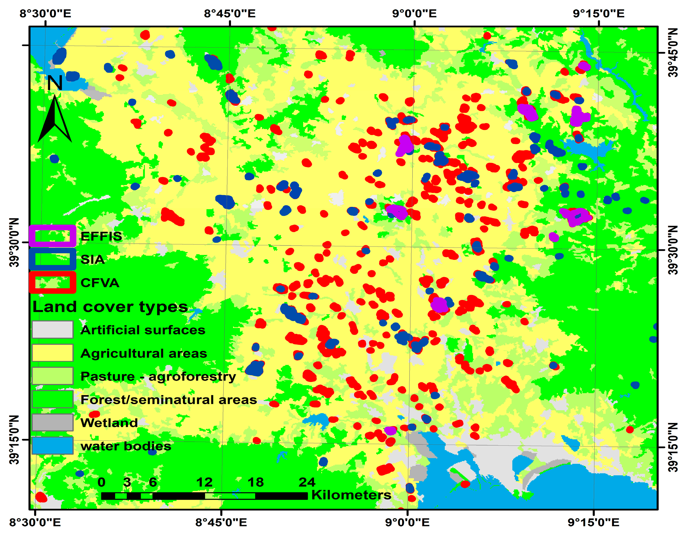
3.2. Results and Discussion of the Local Comparison
3.2.1. 2019 Local Comparison: Sardinia
3.2.2. 2020 Local Comparison: Sardinia
3.2.3. 2020 Local Comparison: Calabria
3.2.4. 2021 Local Comparison: Sicily and Sardinia
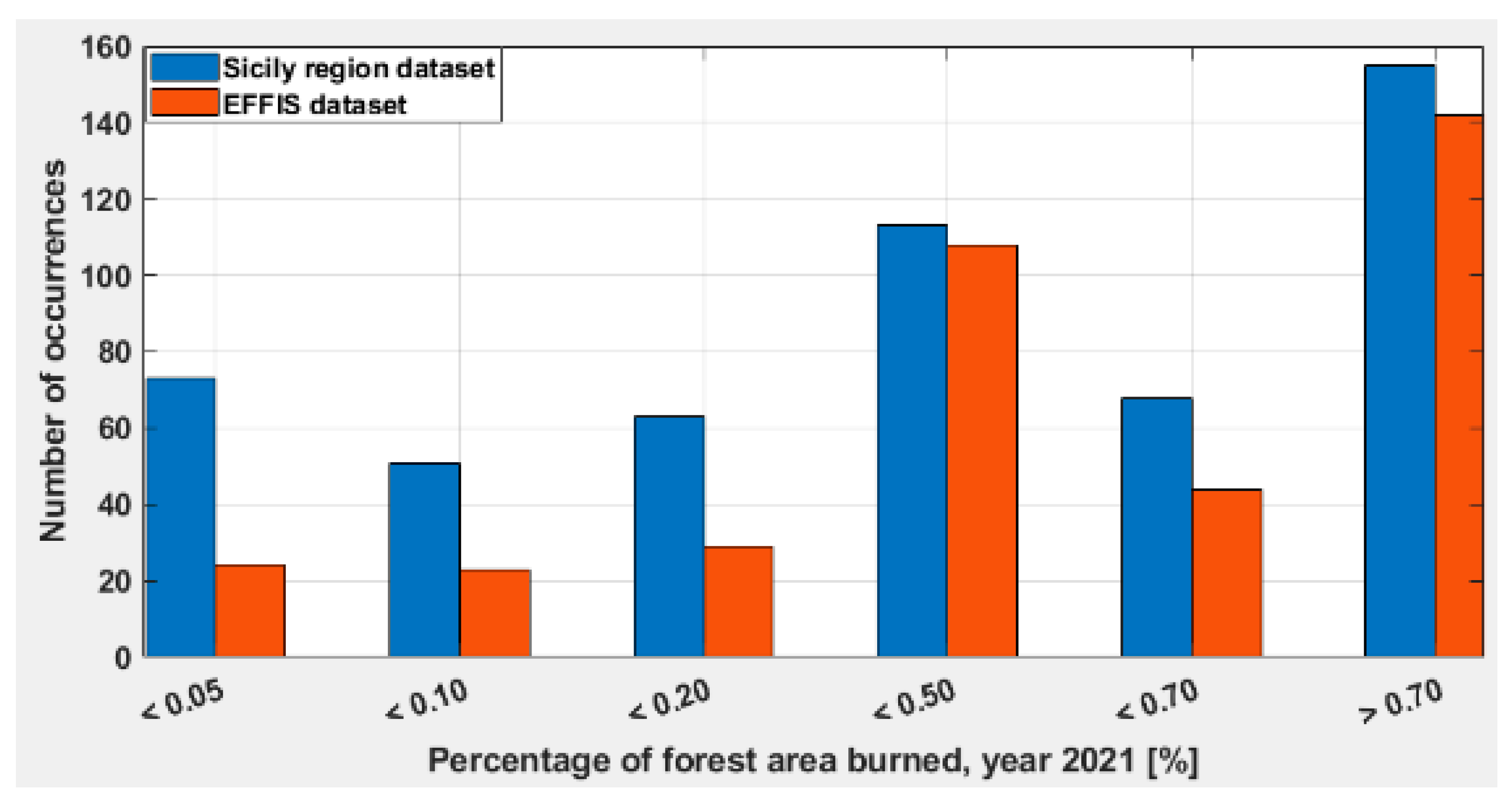
- First of all, despite the number of recorded events being lower, the EFFIS dataset shows a larger amount of BA;
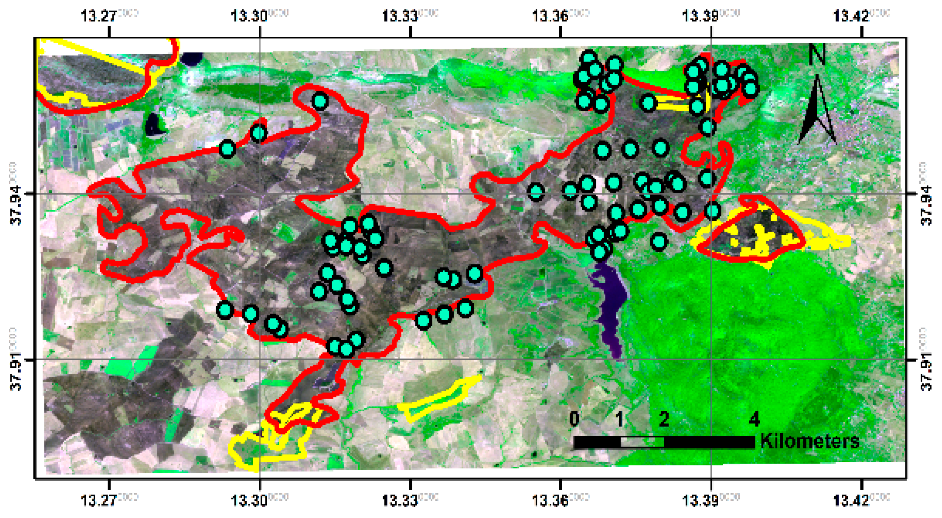
- The correspondence between the BA contained in the two datasets amounts to almost the same value. This could mean that, even if EFFIS tends to detect the larger events, the false-positive rate is still rather high or that a different approach of the regional authority is adopted in the selection of the fires to be delineated. Figure 11, which shows a comparison between the EFFIS polygons (in red) and the ones provided by the Sicilian regional authority (in yellow), seems to corroborate the latter hypothesis. The EFFIS 2867.0 ha BA polygon has no match in the regional dataset apart from two small, yellow polygons located in the upper right and lower left. The BA polygons are super-imposed on a Sentinel-2 false colour composite image (R = band 4, G = band 8, B = band 2) acquired on the 10th of August 2021. The reason for the absence of this large burnt area in the regional BA dataset could be due to the fact that the area is mostly agricultural. The presence of many hotspots (yellow circles), as provided by the FIRMS Webmapper in the period 29 July–1 August, demonstrates the presence of several fires. However, their scattered appearance may also lead us to hypothesise their association with the typical agricultural practice of burning after harvesting. This could explain the absence of the polygon in the regional dataset.
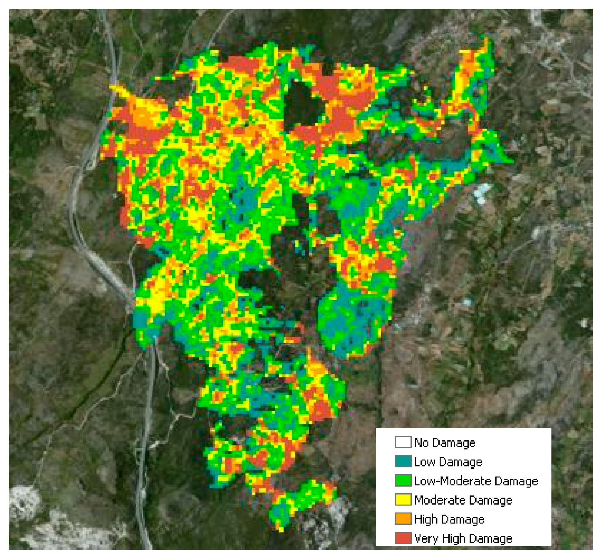
3.3. High-Resolution Burnt Area Maps
3.4. Large Fire Event Analysis: The Montiferru Megafire
4. Conclusions
- A “long-time” (seven-year) analysis, restricted to the Italian country, of the most commonly used BA datasets in Europe;
- A comparison, restricted to some of the Italian regions most affected by summer fires, of BA surveyed in situ with some of the global/continental datasets based on satellite images.
- The development of fire hazard indices that use fires distribution to identify the areas more susceptible to burn;
- The assessment of the annual fire trend;
- The assessment of the extinguishing efficiency;
- The assessment of the efficiency of the fire prevention activity;
- The assessment of the effectiveness of the land management practices.
Author Contributions
Funding
Data Availability Statement
Acknowledgments
Conflicts of Interest
References
- Keeley, J.E. Fire intensity, fire severity and burn severity: A brief review and suggested usage. Int. J. Wildland Fire 2009, 18, 116–126. [Google Scholar] [CrossRef]
- Key, C.H.; Benson, N. Landscape assessment: Ground measure of severity, the composite burn index; and remote sensing of severity, the normalized burn ratio. In FIREMON: Fire Effects Monitoring and Inventory System USDA Forest Service; Lutes, D.C., Keane, R.E., Caratti, J.F., Key, C.H., Benson, N.C., Gangi, L.J., Eds.; Rocky Mountain Research Station: Ogden, UT, USA, 2005. [Google Scholar]
- De Santis, A.; Chuvieco, E. GeoCBI: A Modified Version of the Composite Burn Index for the Initial Assessment of the Short-Term Burn Severity from Remotely Sensed Data. Remote Sens. Environ. 2009, 113, 554–562. [Google Scholar] [CrossRef]
- Garcıa-Llamas, P.; Suarez-Seoane, S.; Fernandez-Guisuraga, J.M.; Fernandez-Garcıa, V.; Fernandez-Manso, A.; Quintano, C.; Taboada, A.; Marcos, E.; Calvo, L. Evaluation and comparison of Landsat 8, Sentinel-2 and Deimos-1 remote sensing indices for assessing burn severity in Mediterranean fire prone ecosystems. Int. J. Appl. Earth. Obs. Geoinf. 2019, 80, 137–144. [Google Scholar] [CrossRef]
- van der Werf, G.R.; Randerson, J.T.; Giglio, L.; van Leeuwen, T.T.; Chen, Y.; Rogers, B.M.; Mu, M.; van Marle, M.J.E.; Morton, D.C.; Collatz, G.J.; et al. Global fire emissions estimates during 1997–2016. Earth Syst. Sci. Data 2017, 9, 697–720. [Google Scholar] [CrossRef]
- Seiler, W.; Crutzen, P.J. Estimates of Gross and Net Fluxes of Carbon between the Biosphere and the Atmosphere from Biomass Burning. In Climatic Change; Springer: Berlin/Heidelberg, Germany, 1980; Volume 2, pp. 207–247. [Google Scholar]
- Laneve, G.; Pampanoni, V.; Shaik, R.U. The Daily Fire Hazard Index: A Fire Danger Rating Method for Mediterranean Areas. Remote Sens. 2020, 12, 2356. [Google Scholar] [CrossRef]
- Liu, S.; Zheng, Y.; Dalponte, M.; Tong, X. A novel fire index-based burned area change detection approach using Landsat-8 OLI data. Eur. J. Remote Sens. 2020, 53, 104–112. [Google Scholar] [CrossRef]
- Polychronaki, A.; Gitas, I.Z. Burned Area Mapping in Greece Using SPOT-4 HRVIR Images and Object-Based Image Analysis. Remote Sens. 2012, 4, 424–438. [Google Scholar] [CrossRef]
- Knopp, L.; Wieland, M.; Rättich, M.; Martinis, S. A Deep Learning Approach for Burned Area Segmentation with Sentinel-2 Data. Remote Sens. 2020, 12, 2422. [Google Scholar] [CrossRef]
- Quintano, C.; Fernández-Manso, A.; Fernández-Manso, O.; Shimabukuro, Y.E. Mapping burned areas in Mediterranean countries using spectral mixture analysis from a uni-temporal perspective. Int. J. Remote Sens. 2006, 27, 645–662. [Google Scholar] [CrossRef]
- Kurbanov, E.; Vorobev, O.; Lezhnin, S.; Sha, J.; Wang, J.; Li, X.; Cole, J.; Dergunov, D.; Wang, Y. Remote Sensing of Forest Burnt Area, Burn Severity, and Post-Fire Recovery: A Review. Remote Sens. 2022, 14, 4714. [Google Scholar] [CrossRef]
- Lopez Garcia, M.J.; Caselles, V. Mapping burns and natural reforestation using Thematic Mapper data. Geocarto Int. 1991, 6, 31–37. [Google Scholar] [CrossRef]
- Gerard, F.; Plummer, S.; Wadsworth, R.; Sanfeliu, A.F.; Iliffe, L.; Balzter, H.; Wyatt, B. Forest fire scar detection in the boreal forest with multitemporal SPOT-VEGETATION data. IEEE Trans. Geosci. Remote Sens. 2003, 41, 2575–2585. [Google Scholar] [CrossRef]
- Martin, M.P. Cartografia e Inventario de Incendios Forestales en la Peninsula Ibérica a Partir de Imagenes NOAA AVHRR. Doctoral Thesis, Universidad de Alcalá, Alcalá de Henares, Madrid, Spain, 1998. [Google Scholar]
- Chuvieco, E.; Martin, M.P.; Palacios, A. Assessment of different spectral indices in the red-near-infrared spectral domain for burned land discrimination. Int. J. Remote Sens. 2002, 23, 5103–5110. [Google Scholar] [CrossRef]
- Trigg, S.; Flasse, S. An evaluation of different bi-spectral spaces for discriminating burned shrub-savannah. Int. J. Remote Sens. 2001, 22, 2641–2647. [Google Scholar] [CrossRef]
- Holden, Z.; Smith, A.M.S.; Morgan, P.; Rollins, M.G.; Gessler, P.E. Comparison of Landsat-derived fire perimeters with fire atlas data: Evaluation of existing and thermally enhanced spectral indices. Int. J. Remote Sens. 2005, 26, 4801–4808. [Google Scholar] [CrossRef]
- Franquesa, M.; Stehman, S.V.; Chuvieco, E. Assessment and characterization of sources of error impacting the accuracy of global burned area products. Remote Sens. Environ. 2022, 280, 113214. [Google Scholar] [CrossRef]
- Lizundia-Loiola, J.; Franquesa, M.; Boettcher, M.; Kirches, G.; Pettinari, M.L.; Chuvieco, E. Implementation of the Burned Area Component of the Copernicus Climate Change Service: From MODIS to OLCI Data. Remote Sens. 2021, 13, 4295. [Google Scholar] [CrossRef]
- Ward, D.; Kloster, S.; Mahowald, N.; Rogers, B.; Randerson, J.; Hess, P. The changing radiative forcing of fires: Global model estimates for past, present and future. Atmos. Chem. Phys. 2012, 12, 10857–10886. [Google Scholar] [CrossRef]
- Poulter, B.; Cadule, P.; Cheiney, A.; Ciais, P.; Hodson, E.; Peylin, P.; Plummer, S.; Spessa, A.; Saatchi, S.; Yue, C. Sensitivity of global terrestrial carbon cycle dynamics to variability in satellite-observed burned area. Glob. Biogeochem. Cycles 2015, 29, 207–222. [Google Scholar] [CrossRef]
- Friedlingstein, P.; O’Sullivan, M.; Jones, M.W.; Andrew, R.M.; Hauck, J.; Olsen, A.; Peters, G.P.; Peters, W.; Pongratz, J.; Sitch, S.; et al. Global Carbon Budget 2020. Earth Syst. Sci. Data 2020, 12, 3269–3340. [Google Scholar] [CrossRef]
- Kelly, L.T.; Brotons, L. Using fire to promote biodiversity. Science 2017, 355, 1264. [Google Scholar] [CrossRef] [PubMed]
- Enright, N.J.; Fontaine, J.B.; Bowman, D.M.J.S.; Bradstock, R.A.; Williams, R.J. Interval squeeze: Altered fire regimes and demographic responses interact to threaten woody species persistence as climate changes. Front. Ecol. Environ. 2015, 13, 265–272. [Google Scholar] [CrossRef] [PubMed]
- Bowman, D.M.J.S.; Balch, J.K.; Artaxo, P.; Bond, W.J.; Carlson, J.M.; Cochrane, M.A.; D’Antonio, C.M.; DeFries, R.S.; Doyle, J.C.; Harrison, S.P.; et al. Fire in the Earth system. Science 2009, 324, 481–484. [Google Scholar] [CrossRef] [PubMed]
- Bojinski, S.; Verstraete, M.; Peterson, T.C.; Richter, C.; Simmons, A.; Zemp, M. The concept of essential climate variables in support of climate research, applications, and policy. Bull. Am. Meteorol. Soc. 2014, 95, 1431–1443. [Google Scholar] [CrossRef]
- Chuvieco, E.; Mouillot, F.; van der Werf, G.R.; San Miguel, J.; Tanase, M.; Koutsias, N.; García, M.; Yebra, M.; Padilla, M.; Gitas, I.; et al. Historical background and current developments for mapping burned area from satellite Earth observation. Remote Sens. Environ. 2019, 225, 45–64. [Google Scholar] [CrossRef]
- Padilla, M.; Stehman, S.V.; Hantson, S.; Oliva, P.; Alonso-Canas, I.; Bradley, A.; Tansey, K.; Mota, B.; Pereira, J.M.; Chuvieco, E. Comparing the Accuracies of Remote Sensing Global Burned Area Products using Stratified Random Sampling and Estimation. Remote Sens. Environ. 2015, 160, 114–121. [Google Scholar] [CrossRef]
- Roteta, E.; Bastarrika, A.; Padilla, M.; Storm, T.; Chuvieco, E. Development of a Sentinel-2 burned area algorithm: Generation of a small fire database for sub-Saharan Africa. Remote Sens. Environ. 2019, 222, 1–17. [Google Scholar] [CrossRef]
- Melchiorre, A.; Boschetti, L. Global Analysis of Burned Area Persistence Time with MODIS Data. Remote Sens. 2018, 10, 750. [Google Scholar] [CrossRef]
- Campagnolo, M.L.; Libonati, R.; Rodrigues, J.A.; Pereira, J.M.C. A comprehensive characterization of MODIS daily burned area mapping accuracy across fire sizes in tropical savannas. Remote Sens. Environ. 2021, 252, 112115. [Google Scholar] [CrossRef]
- Pacheco, A.d.P.; da Silva Junior, J.A.; Ruiz-Armenteros, A.M.; Henriques, R.F.F.; de Oliveira Santos, I. Analysis of Spectral Separability for Detecting Burned Areas Using Landsat-8 OLI/TIRS Images under Different Biomes in Brazil and Portugal. Forests 2023, 14, 663. [Google Scholar] [CrossRef]
- Key, C.H.; Benson, N.C. The Normalized Burn Ratio (NBR): A Landsat TM Radiometric Measure of Burn Severity; US Geological Survey Northern Rocky Mountain Science Center, U.S. Department of the Interior: Bozeman, MT, USA, 2003.
- Alcaras, E.; Costantino, D.; Guastaferro, F.; Parente, C.; Pepe, M. Normalized Burn Ratio Plus (NBR+): A new index for Sentinel-2 imagery. Remote Sens. 2022, 14, 1727. [Google Scholar] [CrossRef]
- Filipponi, F. BAIS2: Burned Area Index for Sentinel-2. Multidiscip. Digit. Publ. Inst. Proc. 2018, 2, 364. [Google Scholar] [CrossRef]
- San-Miguel-Ayanz, J.; Barbosa, P.M.; Schmunk, G.; Liberta, G. The European Forest Fire Information System (EFFIS). In Proceedings of the Joint Workshop of Earsel SIG and GOFC/GOLD: Innovative Concepts and Methods in Fire Danger Estimation, Ghent, Belgium, 5–7 June 2003. [Google Scholar]
- Giglio, L.; Schroeder, W.; Justice, C.O. The collection 6 MODIS active fire detection algorithm and fire products. Remote Sens. Environ. 2016, 178, 31–41. [Google Scholar] [CrossRef] [PubMed]
- Tansey, K.; Grégoire, J.M.; Defourny, P.; Leigh, R.; Pekel, J.F.; van Bogaert, E.; Bartholomé, E. A new, global, multi-annual (2000–2007) burnt area product at 1 km resolution. Geophys. Res. Lett. 2008, 35, L01401. [Google Scholar] [CrossRef]
- Chuvieco, E.; Lizundia-Loiola, J.; Pettinari, M.L.; Ramo, R.; Padilla, M.; Tansey, K.; Mouillot, F.; Laurent, P.; Storm, T.; Heil, A.; et al. Generation and analysis of a new global burned area product based on MODIS 250 m reflectance bands and thermal anomalies. Earth Syst. Sci. Data 2018, 10, 2015–2031. [Google Scholar] [CrossRef]
- Oliva, P.; Schroeder, W. Assessment of VIIRS 375m active fire detection product for direct burned area mapping. Remote Sens. Environ. 2015, 160, 144–155. [Google Scholar] [CrossRef]
- Zhu, C.; Kobayashi, H.; Kanaya, Y.; Saito, M. Size-dependent validation of MODIS MCD64A1 burned area over six vegetation types in boreal Eurasia: Large underestimation in croplands. Sci. Rep. 2017, 7, 4181. [Google Scholar] [CrossRef]
- Oliva, P.; Martín, P.; Chuvieco, E. Burned area mapping with MERIS post-fire image. Int. J. Remote Sens. 2011, 32, 4175–4201. [Google Scholar] [CrossRef]
- Boschetti, L.; Roy, D.P.; Giglio, L.; Huang, H.; Zubkova, M.; Humber, M.L. Global validation of the collection 6 MODIS burned area product. Remote Sens. Environ. 2019, 235, 111490. [Google Scholar] [CrossRef]
- Stroppiana, D.; Bordogna, G.; Sali, M.; Boschetti, M.; Sona, G.; Brivio, P.A. A fully automatic, interpretable and adaptive machine learning approach to map burned area from remote sensing. ISPRS Int. J. Geo-Inf. 2021, 10, 546. [Google Scholar] [CrossRef]
- Campagnolo, M.L.; Oom, D.; Padilla, M.; Pereira, J.M.C. A patch-based algorithm for global and daily burned area mapping. Remote Sens. Environ. 2019, 232, 111288. [Google Scholar] [CrossRef]
- Enna, M. Il Peggiore Incendio Subito Dalla Sardegna è Rimasto Senza Colpevoli, Agenzia Giornalistica Italia, Roma, 2022. Available online: https://www.agi.it/cronaca/news/2022-07-22/incendi-sardegna-rogo-montiferru-2021-senza-colpevoli-17526940/ (accessed on 17 December 2023).


| EFFIS | FIRMS | CGLS | CCI | Common Burnt Areas | Total Burnt Areas | |
|---|---|---|---|---|---|---|
| EFFIS | - | TP | TP | TP | Percentage of BAs common to EFFIS and at least two other datasets | Total EFFIS BA |
| FIRMS | TP | - | TP | TP | Percentage of BAs common to FIRMS and at least two other datasets | Total FIRMS BA |
| CGLS | TP | TP | - | TP | Percentage of BAs common to CGLS and at least two other datasets | Total CGLS BA |
| CCI | TP | TP | TP | - | Percentage of BAs common to CCI and at least two other datasets | Total CCI BA |
| Dataset | Source | Spatial Resolution | Timespan | Algorithm/Method Used |
|---|---|---|---|---|
| ESA CCI | MODIS | 250 m | 2001–present | NIR time series + active fires |
| CGLS | VGT (PROBA-V) | 300 m | 2014–present | Reflectance change |
| EFFIS | MODIS | 250 m | 2000–present | Combination of bands |
| FIRMS/MCD64 | MODIS | 250 m * | 2000–present | NBR2 + active fire |
| C3S | OLCI | 300 m | 2017–2020 | NIR time series + active fires |
| CUFA | GPS | - | 2020–present | Ground survey |
| CFVA | GPS | - | 2005–present | Ground survey |
| SIA | Sentinel-2 | 20 m | 2020–present | NBR |
| EFFIS | FIRMS | CGLS | CCI | Common Burnt Areas in 7 Years in % | Total Burnt Areas in 7 Years (km2) | |
|---|---|---|---|---|---|---|
| EFFIS | - | 32.3% | 22.26% | 50.14% | 32.7% | 4068.0 |
| FIRMS | 23.9% | - | 15.3% | 40.30% | 23.8% | 5496.0 |
| CGLS | 4.1% | 4.25% | - | 9.1% | 4.3% | 22,313.0 |
| CCI | 14.7% | 15.93 | 14.6% | - | 10.8% | 13,895.0 |
| EFFIS | FIRMS | CGLS | CCI | Total Number of Events in 7 Years | |
|---|---|---|---|---|---|
| EFFIS | - | 44.7% | 24.21% | 40.31% | 2714 |
| FIRMS | 26.71% | - | 46.5% | 49.12% | 2445 |
| CGLS | 2.21% | 2.28% | - | 6.21% | 73,547 |
| CCI | 20.38% | 21.97 | 49.75% | - | 6099 |
| Database 2019 | Tot. Burnt Areas (ha) | Number of Areas | Correspondence CFVA vs. Other | Correspondence Other vs. CFVA |
|---|---|---|---|---|
| CFVA | 6758.0 | 1428 | ||
| EFFIS | 4343.0 | 25 | 2.9% | 72.0% |
| FIRMS | 2800.0 | 53 | 1.0% | 37.7% |
| CCI | 1810.7 | 23 | 1.7% | 61.0% |
| C3S | 2673.0 | 13 | 1.8% | 76.9% |
| Database 2019 | CORINE Classes Agricultural (from 211 to 242) (ha) | CORINE Classes Forest and Seminatural (from 243 to 333) (ha) | Other Classes (ha) | Difference in Forest Area (%) (Omission) |
|---|---|---|---|---|
| CFVA | 4215.0 | 2479.0 | 64.0 | - |
| EFFIS | 2330.0 | 1959.0 | 53.0 | 21.0% |
| FIRMS | 1811.0 | 902.0 | 87.0 | 63.6% |
| CCI | 463.0 | 1317.0 | 30.8 | 46.9% |
| C3S | 1571.0 | 1101.6 | 0.0 | 55.6% |
| Database | Tot. Burnt Areas (ha) | Number of Areas | Correspondence CFVA vs. Other | Correspondence Other vs. CFVA |
|---|---|---|---|---|
| CFVA | 7985.0 | 932 | - | - |
| EFFIS | 4536.0 | 34 | 3.8% | 89.0% |
| FIRMS | 2549.0 | 30 | 3.5% | 53.0% |
| CCI | 5299.0 | 31 | 1.7% | 45.0% |
| C3S | 4358.0 | 10 | 1.3% | 100.0% |
| Database | CORINE Classes Agricultural (from 211 to 242) (ha) | CORINE Classes Forest and Seminatural (from 243 to 333) (ha) | Other Classes (ha) | Difference on Forest Area (%) (Omission) |
|---|---|---|---|---|
| CFVA | 4554.0 | 3364.0 | 67.0 | - |
| EFFIS * | 1935.0 | 2785.0 | 0.0 | 13.4% |
| FIRMS | 1224.4 | 1312.0 | 13.0 | 59.0% |
| CCI | 2665.0 | 2620.0 | 13.7 | 18.4% |
| C3S | 2285.0 | 2064.0 | 8.0 | 35.7% |
| Database | CORINE Classes Agricultural (from 211 to 242) (ha) | Agricultural from Polygons (ha) | CORINE Classes Forest and Seminatural (from 243 to 333) (ha) | Forest + Seminatural from Polygons (ha) |
|---|---|---|---|---|
| CFVA | 4554.0 | 4713.0 | 3364.0 | 3272.0 |
| EFFIS | 1935.0 | 2435.0 | 2785.0 | 2083.0 |
| Database | Tot. Burnt Areas (ha) Forest (All Cover Types) | Number of Areas | Correspondence CUFA vs. Other | Correspondence Other vs. CUFA |
|---|---|---|---|---|
| CUFA | 3254.5 | 599 | - | - |
| EFFIS | 3789.0 (9185.0) * | 278 | 21.7% | 38.5% |
| FIRMS | 753.0 (2066.0) | 40 | 1.5% | 37.5% |
| CCI | 2466.0 (7635.6) | 89 | 5.0% | 29.0% |
| C3S | 3329.0 (8192.0) | 79 | 7.3% | 36.7% |
| Database | Tot. Burnt Areas (ha) | Number of Areas | Correspondence Reg. vs. EFFIS | Correspondence EFFIS vs. Reg |
|---|---|---|---|---|
| Reg. auth. | 57,420.0 | 1000 | - | - |
| EFFIS | 62,302.0 | 621 | 33.7% | 32.85% |
| Dataset | Number of BA | Correspondence HS and BA | BA and HS |
|---|---|---|---|
| EFFIS BA | 621 | 12,649 (50.0%) | 545 (82.4%) |
| Sicily region BA | 940 | 23,553 (93.2%) | 462 (49.1%) |
| Database | Tot. Burnt Areas (ha) | Number of Areas | Correspondence CFVA vs. Other | Correspondence Other vs. CFVA |
|---|---|---|---|---|
| CFVA | 25,840.0 | 1108 (609) 1 | - | - |
| EFFIS | 18,283.0 | 42 | 4.4% | 83.3% |
| SIA | 26,250.0 | 544 (2100) 2 | 22.0% | 57.9% |
| Database | Tot. Burnt Area (ha) | Forest Area Burnt (ha) | Difference |
|---|---|---|---|
| CFVA | 12,555.0 | 4177.1 | - |
| EFFIS | 13,278.0 | 6535.5 | 61.8% |
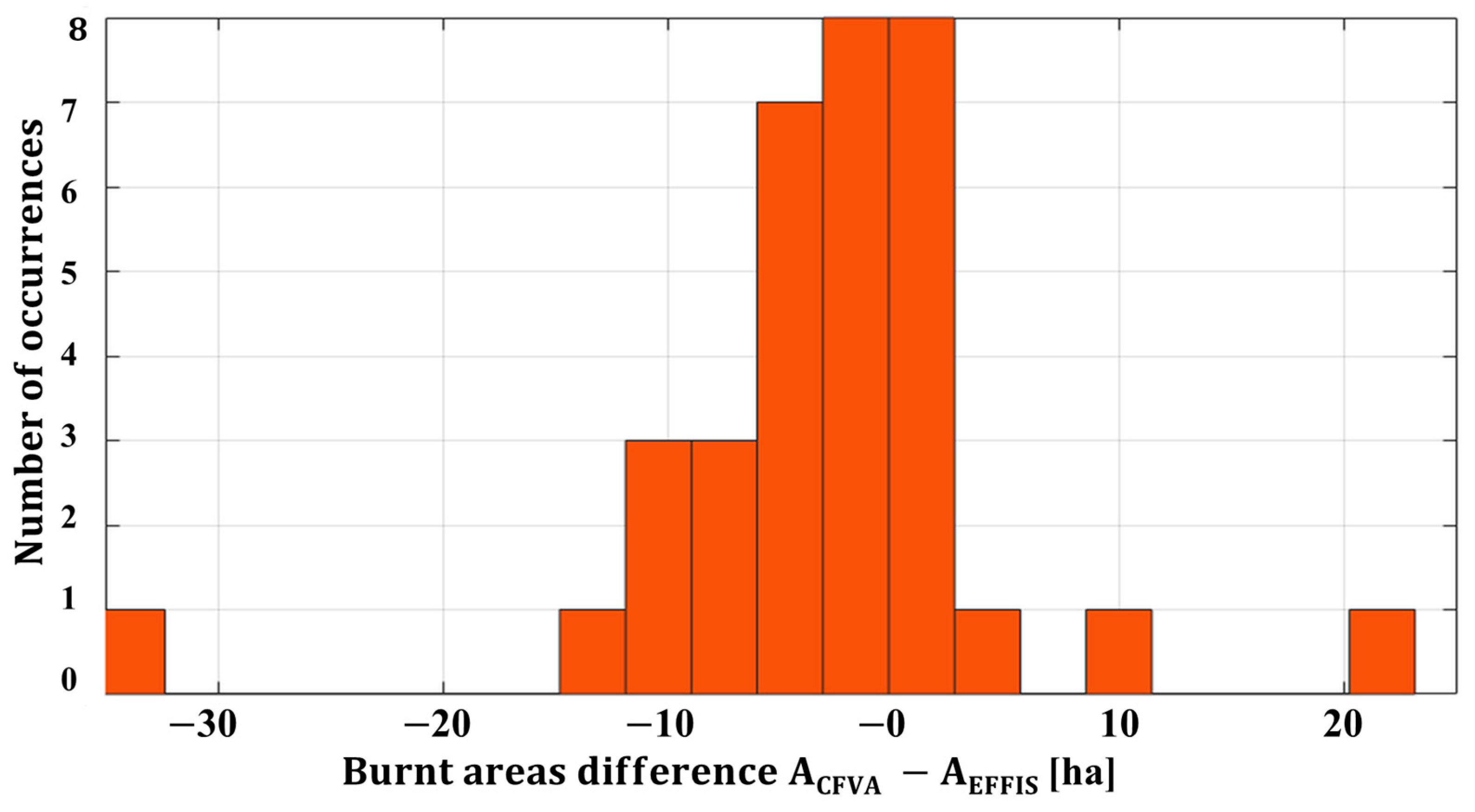
| SIA | 10,907.0 | 4044.3 | −3.2% |
Disclaimer/Publisher’s Note: The statements, opinions and data contained in all publications are solely those of the individual author(s) and contributor(s) and not of MDPI and/or the editor(s). MDPI and/or the editor(s) disclaim responsibility for any injury to people or property resulting from any ideas, methods, instructions or products referred to in the content. |
© 2023 by the authors. Licensee MDPI, Basel, Switzerland. This article is an open access article distributed under the terms and conditions of the Creative Commons Attribution (CC BY) license (https://creativecommons.org/licenses/by/4.0/).
Share and Cite
Laneve, G.; Di Fonzo, M.; Pampanoni, V.; Bueno Morles, R. Progress and Limitations in the Satellite-Based Estimate of Burnt Areas. Remote Sens. 2024, 16, 42. https://doi.org/10.3390/rs16010042
Laneve G, Di Fonzo M, Pampanoni V, Bueno Morles R. Progress and Limitations in the Satellite-Based Estimate of Burnt Areas. Remote Sensing. 2024; 16(1):42. https://doi.org/10.3390/rs16010042
Chicago/Turabian StyleLaneve, Giovanni, Marco Di Fonzo, Valerio Pampanoni, and Ramon Bueno Morles. 2024. "Progress and Limitations in the Satellite-Based Estimate of Burnt Areas" Remote Sensing 16, no. 1: 42. https://doi.org/10.3390/rs16010042