
Impacts of Marine Heatwave Events on Three Distinct Upwelling Systems and Their Implications for Marine Ecosystems in the Northwestern South China Sea
Abstract
:1. Introduction
2. Data and Methods
2.1. Data Sources
2.2. Method
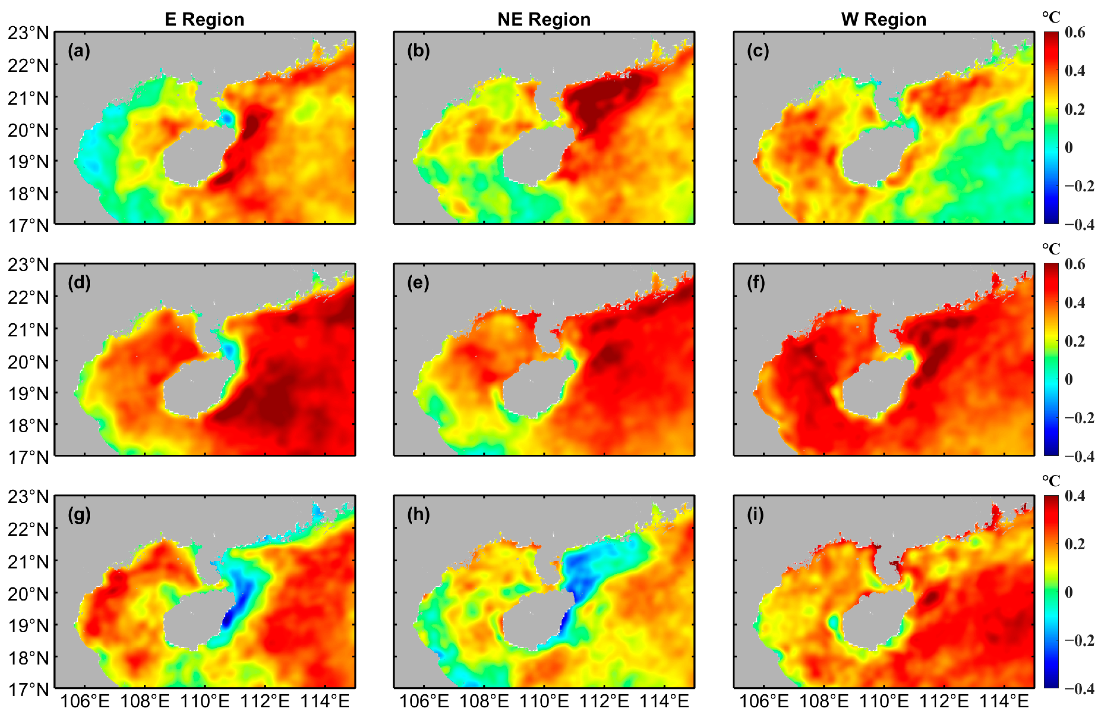
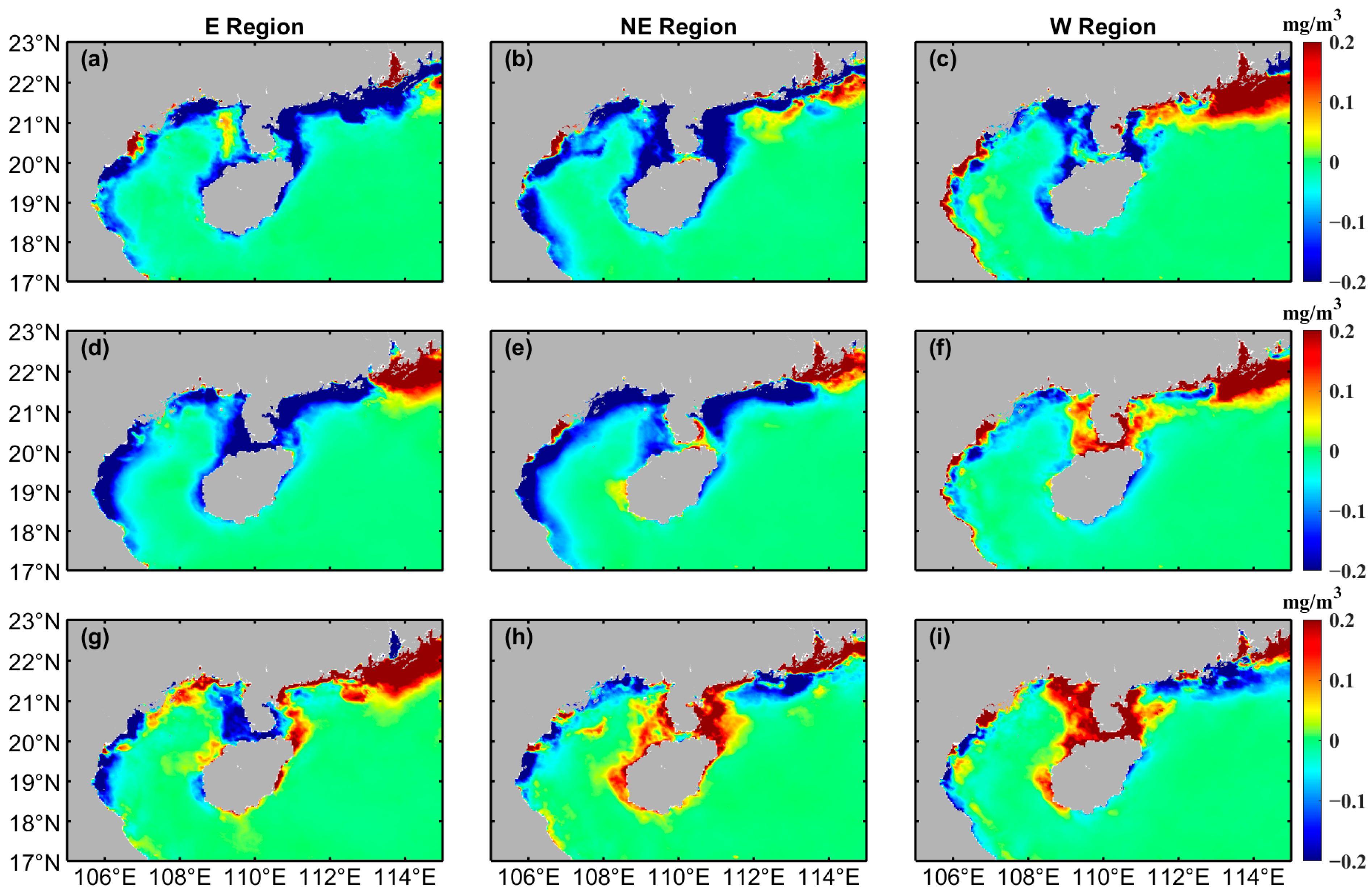
3. Results
4. Discussion
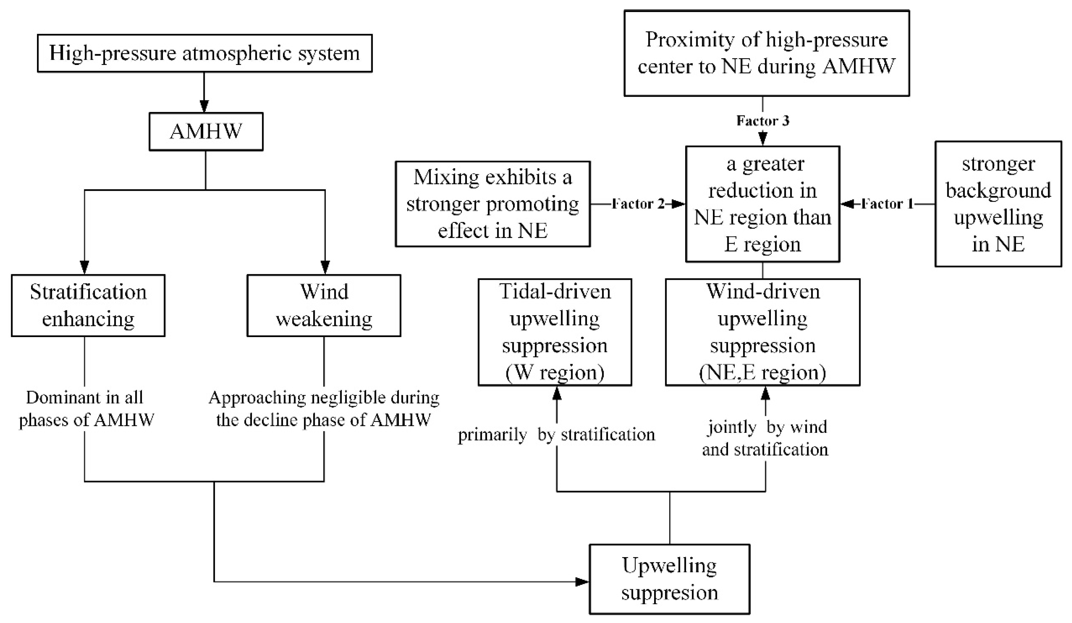
4.1. Wind Weakening and Stratification Enhancing during AMHW Events
4.2. The Inhibitory Effects of AMHW on Upwelling
4.3. The Contributions of Stratification Enhancement and Wind Weakening to the Decrease in Chl-a Concentration during Different Phases of AMHW
4.4. The Impact of AMHW on Marine Ecosystems
5. Conclusions
Author Contributions
Funding
Data Availability Statement
Conflicts of Interest
References
- Hu, J.; Wang, X.H. Progress on upwelling studies in the China seas. Rev. Geophys. 2016, 54, 653–673. [Google Scholar] [CrossRef]
- Bakun, A. Global climate change and intensification of coastal ocean upwelling. Science 1990, 247, 198–201. [Google Scholar] [CrossRef] [PubMed]
- Hu, D. Upwelling and sedimentation dynamics. I. The role of upwelling in sedimentation in the Huanghai Sea and East China Sea—A description of general features. Chin. J. Oceanol. Limnol. 1984, 2, 12–19. [Google Scholar]
- Chavez, F.P. Physical estimates of global new production:the upwelling contribution. In Upwelling in the Ocean: Modern Processes and Ancient Records; Wiley; John & Sons: New York, NY, USA, 1995. [Google Scholar]
- Pauly, D.; Christensen, V. Primary production required to sustain global fisheries. Nature 1995, 374, 255–257. [Google Scholar] [CrossRef]
- Ianson, D.; Feely, R.A.; Sabine, C.L.; Juranek, L.W. Features of Coastal Upwelling Regions that Determine Net Air-Sea CO2 Flux. J. Oceanogr. 2009, 65, 677–687. [Google Scholar] [CrossRef]
- Barth, J.A.; Menge, B.A.; Lubchenco, J.; Chan, F.; Bane, J.M.; Kirincich, A.R.; McManus, M.A.; Nielsen, K.J.; Pierce, S.D.; Washburn, L. Delayed upwelling alters nearshore coastal ocean ecosystems in the northern California current. Proc. Natl. Acad. Sci. USA 2007, 104, 3719–3724. [Google Scholar] [CrossRef]
- Xie, S.P.; Xie, Q.; Wang, D.X.; Liu, W.T. Summer upwelling in the South China Sea and its role in regional climate variations. J. Geophys. Res. Ocean. 2003, 108. [Google Scholar] [CrossRef]
- Benthuysen, J.A.; Oliver, E.C.J.; Chen, K.; Wernberg, T. Advances in understanding marine heatwaves and their impacts. Front. Mar. Sci. 2020, 7, 147. [Google Scholar] [CrossRef]
- Hughes, T.P.; Anderson, K.D.; Connolly, S.R.; Heron, S.F.; Kerry, J.T.; Lough, J.M.; Baird, A.H.; Baum, J.K.; Berumen, M.L.; Bridge, T.C.; et al. Spatial and temporal patterns of mass bleaching of corals in the Anthropocene. Science 2018, 359, 80–83. [Google Scholar] [CrossRef]
- Smale, D.A.; Wernberg, T.; Oliver, E.C.J.; Thomsen, M.; Harvey, B.P.; Straub, S.C.; Burrows, M.T.; Alexander, L.V.; Benthuysen, J.A.; Donat, M.G.; et al. Marine heatwaves threaten global biodiversity and the provision of ecosystem services. Nat. Clim. Chang. 2019, 9, 306–312. [Google Scholar] [CrossRef]
- Sen Gupta, A.; Thomsen, M.; Benthuysen, J.A.; Hobday, A.J.; Oliver, E.; Alexander, L.V.; Burrows, M.T.; Donat, M.G.; Feng, M.; Holbrook, N.J.; et al. Drivers and impacts of the most extreme marine heatwave events. Sci. Rep. 2020, 10, 19359. [Google Scholar] [CrossRef] [PubMed]
- Seabra, R.; Varela, R.; Santos, A.M.; Gómez-Gesteira, M.; Meneghesso, C.; Wethey, D.S.; Lima, F.P. Reduced nearshore warming associated with eastern boundary upwelling systems. Front. Mar. Sci. 2019, 6, 104. [Google Scholar] [CrossRef]
- Varela, R.; Rodríguez-Díaz, L.; de Castro, M.; Gómez-Gesteira, M. Influence of Eastern Upwelling systems on marine heatwaves occurrence. Glob. Planet. Chang. 2021, 196, 103379. [Google Scholar] [CrossRef]
- García-Reyes, M.; Sydeman, W.J.; Schoeman, D.S.; Rykaczewski, R.R.; Black, B.A.; Smit, A.J.; Bograd, S.J. Under pressure: Climate change, upwelling, and eastern boundary upwelling ecosystems. Front. Mar. Sci. 2015, 2, 109. [Google Scholar] [CrossRef]
- Gruber, N. Warming up, turning sour, losing breath: Ocean biogeochemistry under global change. Philos. Trans. R. Soc. A-Math. Phys. Eng. Sci. 2011, 369, 1980–1996. [Google Scholar] [CrossRef] [PubMed]
- Sousa, M.C.; Ribeiro, A.; Des, M.; Gomez-Gesteira, M.; deCastro, M.; Dias, J.M. NW Iberian Peninsula coastal upwelling future weakening: Competition between wind intensification and surface heating. Sci. Total Environ. 2020, 703, 134808. [Google Scholar] [CrossRef] [PubMed]
- Noh, K.M.; Lim, H.-G.; Kug, J.-S. Global chlorophyll responses to marine heatwaves in satellite ocean color. Environ. Res. Lett. 2022, 17, 064034. [Google Scholar] [CrossRef]
- Tan, H.J.; Cai, R.S.; Wu, R.G. Summer marine heatwaves in the South China Sea: Trend, variability and possible causes. Adv. Clim. Chang. Res. 2022, 13, 323–332. [Google Scholar] [CrossRef]
- Li, Y.; Ren, G.; Wang, Q.; Mu, L.; Niu, Q. Marine Heatwaves in the South China Sea: Tempo-Spatial Pattern and Its Association with Large-Scale Circulation. Remote Sens. 2022, 14, 5829. [Google Scholar] [CrossRef]
- He, W.; Zeng, X.; Deng, L.; Pi, Q.L.C.; Zhao, J. Enhanced impact of prolonged MHWs on satellite-observed chlorophyll in the South China Sea. Prog. Oceanogr. 2023, 218, 103123. [Google Scholar] [CrossRef]
- Li, L. Summer upwelling system over the northern continental shelf of the South China Sea: A physical description. In Proceedings of the Symposium on the Physical and Chemical Oceanography of the China Seas; China Ocean Press: Beijing, China, 1993; pp. 58–68. [Google Scholar]
- Lin, P.; Hu, J.; Zheng, Q.; Sun, Z.; Zhu, J. Observation of summertime upwelling off the eastern and northeastern coasts of Hainan Island, China. Ocean Dyn. 2016, 66, 387–399. [Google Scholar] [CrossRef]
- Zhu, J.; Zhou, Q.; Zhou, Q.; Geng, X.; Shi, J.; Guo, X.; Yu, Y.; Yang, Z.; Fan, R. Interannual variation of coastal upwelling around Hainan Island. Front. Mar. Sci. 2023, 10, 1054669. [Google Scholar] [CrossRef]
- Xie, L.; Zhang, S.; Zhao, H. Overview of studies on Qiongdong upwelling. J. Trop. Oceanogr. 2012, 31, 35–41. (In Chinese) [Google Scholar]
- Jing, Z.Y.; Qi, Y.Q.; Hua, Z.L.; Zhang, H. Numerical study on the summer upwelling system in the northern continental shelf of the South China Sea. Cont. Shelf Res. 2009, 29, 467–478. [Google Scholar] [CrossRef]
- Xie, L.; Zong, X.; Yi, X.; Li, M. The interannual variation and long-term trend of Qiongdong upwelling. Oceanol. Limnol. Sin 2016, 47, 43–51. (In Chinese) [Google Scholar]
- Shu, Y.; Wang, Q.; Zu, T. Progress on shelf and slope circulation in the northern South China Sea. Sci. China Earth Sci. 2018, 61, 560–571. [Google Scholar] [CrossRef]
- Song, X.; Lai, Z.; Ji, R.; Chen, C.; Zhang, J.; Huang, L.; Yin, J.; Wang, Y.; Lian, S.; Zhu, X. Summertime primary production in northwest South China Sea: Interaction of coastal eddy, upwelling and biological processes. Cont. Shelf Res. 2012, 48, 110–121. [Google Scholar] [CrossRef]
- Wang, D.; Shu, Y.; Xue, H.; Hu, J.; Chen, J.; Zhuang, W.; Zu, T.; Xu, J. Relative contributions of local wind and topography to the coastal upwelling intensity in the northern South China Sea. J. Geophys. Res. Ocean. 2014, 119, 2550–2567. [Google Scholar] [CrossRef]
- Chen, Z.; Qiao, F.; Xia, C.; Wang, G. The numerical investigation of seasonal variation of the cold water mass in the Beibu Gulf and its mechanisms. Acta Oceanol. Sin. 2015, 34, 44–54. [Google Scholar] [CrossRef]
- Gao, J.; Wu, G.; Ya, H. Review of the circulation in the Beibu Gulf, South China Sea. Cont. Shelf Res. 2017, 138, 106–119. [Google Scholar] [CrossRef]
- Bai, P.; Ling, Z.; Zhang, S.; Xie, L.; Yang, J. Fast-changing upwelling off the west coast of Hainan Island. Ocean Model. 2020, 148, 101589. [Google Scholar] [CrossRef]
- Bai, P.; Yang, J.; Zhang, S.; Xie, L.; Wu, J. Upwelling off the west coast of Hainan Island: Sensitivity to wave-mixing. Acta Oceanol. Sin. 2019, 38, 11–19. [Google Scholar] [CrossRef]
- Lue, X.; Qiao, F.; Wang, G.; Xia, C.; Yuan, Y. Upwelling off the west coast of Hainan Island in summer: Its detection and mechanisms. Geophys. Res. Lett. 2008, 35. [Google Scholar] [CrossRef]
- Hobday, A.J.; Alexander, L.V.; Perkins, S.E.; Smale, D.A.; Straub, S.C.; Oliver, E.C.J.; Benthuysen, J.A.; Burrows, M.T.; Donat, M.G.; Peng, M.; et al. A hierarchical approach to defining marine heatwaves. Prog. Oceanogr. 2016, 141, 227–238. [Google Scholar] [CrossRef]
- Good, S.; Fiedler, E.; Mao, C.; Martin, M.J.; Maycock, A.; Reid, R.; Roberts-Jones, J.; Searle, T.; Waters, J.; While, J.; et al. The current configuration of the OSTIA system for operational production of foundation sea surface temperature and ice concentration analyses. Remote Sens. 2020, 12, 720. [Google Scholar] [CrossRef]
- Hersbach, H.; Bell, B.; Berrisford, P.; Biavati, G.; Horányi, A.; Muñoz Sabater, J.; Nicolas, J.; Peubey, C.; Radu, R.; Rozum, I. ERA5 monthly averaged data on single levels from 1979 to present. Copernic. Clim. Chang. Serv. Clim. Data Store 2019, 10, 252–266. [Google Scholar]
- Price, J.F. Upper Ocean response to a hurricane. J. Phys. Oceanogr. 1981, 11, 153–175. [Google Scholar] [CrossRef]
- Yelland, M.J.; Moat, B.I.; Taylor, P.K.; Pascal, R.W.; Hutchings, J.; Cornell, V.C. Wind stress measurements from the open ocean corrected for airflow distortion by the ship. J. Phys. Oceanography. 1998, 28, 1511–1526. [Google Scholar] [CrossRef]
- Schlegel, R.W.; Smit, A.J. heatwaveR: A central algorithm for the detection of heatwaves and cold-spells. J. Open Source Softw. 2018, 3, 821. [Google Scholar] [CrossRef]
- Zhao, Z.; Marin, M. A MATLAB toolbox to detect and analyze marine heatwaves. J. Open Source Softw. 2019, 4, 1124. [Google Scholar] [CrossRef]
- Zhan, W.; Zhang, Y.; He, Q.; Zhan, H. Shifting responses of phytoplankton to atmospheric and oceanic forcing in a prolonged marine heatwave. Limnol. Oceanogr. 2023, 68, 1821–1834. [Google Scholar] [CrossRef]
- Dalsin, M.; Walter, R.K.; Mazzini, P.L.F. Effects of basin-scale climate modes and upwelling on nearshore marine heatwaves and cold spells in the California Current. Sci. Rep. 2023, 13, 12389. [Google Scholar] [CrossRef] [PubMed]
- Jung, J.; Cho, Y.-K. Effects of Surface Heating on Coastal Upwelling Intensity. J. Geophys. Res. Ocean. 2023, 128, e2022JC018795. [Google Scholar] [CrossRef]
- Bond, N.A.; Cronin, M.F.; Freeland, H.; Mantua, N. Causes and impacts of the 2014 warm anomaly in the NE Pacific. Geophys. Res. Lett. 2015, 42, 3414–3420. [Google Scholar] [CrossRef]
- Rodrigues, R.R.; Taschetto, A.S.; Sen Gupta, A.; Foltz, G.R. Common cause for severe droughts in South America and marine heatwaves in the South Atlantic. Nat. Geosci. 2019, 12, 620–626. [Google Scholar] [CrossRef]
- Yao, Y.; Wang, C. Variations in summer marine heatwaves in the South China Sea. J. Geophys. Res. Ocean. 2021, 126, e2021JC017792. [Google Scholar] [CrossRef]
- He, C.; Zhou, T.; Lin, A.; Wu, B.; Gu, D.; Li, C.; Zheng, B. Enhanced or weakened western North Pacific subtropical high under global warming? Sci. Rep. 2015, 5, 16771. [Google Scholar] [CrossRef] [PubMed]
- Kosaka, Y.; Xie, S.-P.; Lau, N.-C.; Vecchi, G.A. Origin of seasonal predictability for summer climate over the Northwestern Pacific. Proc. Natl. Acad. Sci. USA 2013, 110, 7574–7579. [Google Scholar] [CrossRef]
- Wang, B.; Wu, R.; Lau, W. Interannual Variability of the Asian Summer Monsoon: Contrasts between the Indian and the Western North Pacific-East Asian Monsoons. J. Clim. 2001, 14, 4073–4090. [Google Scholar] [CrossRef]
- Wang, B.; Xiang, B.; Lee, J.-Y. Subtropical High predictability establishes a promising way for monsoon and tropical storm predictions. Proc. Natl. Acad. Sci. USA 2013, 110, 2718–2722. [Google Scholar] [CrossRef]
- Wu, B.; Zhou, T.; Li, T. Seasonally Evolving Dominant Interannual Variability Modes of East Asian Climate. J. Clim. 2009, 22, 2992–3005. [Google Scholar] [CrossRef]
- Feng, Y.; Bethel, B.J.; Dong, C.; Zhao, H.; Yao, Y.; Yu, Y. Marine heatwave events near Weizhou Island, Beibu Gulf in 2020 and their possible relations to coral bleaching. Sci. Total Environ. 2022, 823, 153414. [Google Scholar] [CrossRef] [PubMed]
- Yoon, D.; Cha, D.-H.; Lee, G.; Park, C.; Lee, M.-I.; Min, K.-H. Impacts of Synoptic and Local Factors on Heat Wave Events over Southeastern Region of Korea in 2015. J. Geophys. Res.-Atmos. 2018, 123, 12081–12096. [Google Scholar] [CrossRef]
- Sohn, B.-J.; Chung, H.-S.; Kim, D.; Perkey, D.; Robertson, F.; Smith, E. Use of Satellite-Derived Water Vapor Data to Investigate Northwestward Expansion of North Pacific Subtropical High during 1995 Summer. J. Meteorol. Soc. Jpn. 2001, 79, 1059–1075. [Google Scholar] [CrossRef]
- Benazzouz, A.; Pelegrí, J.L.; Demarcq, H.; Machín, F.; Mason, E.; Orbi, A.; Peña-Izquierdo, J.; Soumia, M. On the temporal memory of coastal upwelling off NW Africa. J. Geophys. Res. Ocean. 2014, 119, 6356–6380. [Google Scholar] [CrossRef]
- Marcello, J.; Hernández-Guerra, A.; Eugenio, F.; Fonte, A. Seasonal and temporal study northwest African upwelling System. Int. J. Remote Sens. 2011, 32, 1843–1859. [Google Scholar] [CrossRef]
- Shi, W.; Huang, Z.; Hu, J. Using TPI to Map Spatial and Temporal Variations of Significant Coastal Upwelling in the Northern South China Sea. Remote Sens. 2021, 13, 1065. [Google Scholar] [CrossRef]
- Shu, Y.; Wang, D.; Feng, M.; Geng, B.; Chen, J.; Yao, J.; Xie, Q.; Liu, Q.Y. The contribution of local wind and ocean circulation to the interannual variability in coastal upwelling intensity in the Northern South China Sea. J. Geophys. Res. Ocean. 2018, 123, 6766–6778. [Google Scholar] [CrossRef]
- Jung, J.; Cho, Y.-K. Persistence of coastal upwelling after a plunge in upwelling-favourable wind. Sci. Rep. 2020, 10, 11938. [Google Scholar] [CrossRef]
- Bakun, A. Coastal Upwelling Indices, West Coast of North America, 1946-71; NOAA Technical Report NMFS SSRF; National Marine Fisheries Service: Silver Spring, MD, USA, 1973; Volume 671.
- Bakun, A. Daily and Weekly Upwelling Indices, West Coast of North America, 1967-73; NOAA Technical Report NMFS SSRF; National Marine Fisheries Service: Silver Spring, MD, USA, 1975; Volume 693.
- Lao, Q.; Lu, X.; Chen, F.; Jin, G.; Chen, C.; Zhou, X.; Zhu, Q. Effects of upwelling and runoff on water mass mixing and nutrient supply induced by typhoons: Insight from dual water isotopes tracing. Limnol. Oceanogr. 2023, 68, 284–295. [Google Scholar] [CrossRef]
- Kunarso, K.; Hadi, S.; Ningsih, N.; Baskoro, M.; Wirasatriya, A.; Kuswardani, A. The classification of upwelling indicators base on sea surface temperature, chlorophyll-a and upwelling index, the case study in Southern Java to Timor Waters. IOP Conf. Ser. Earth Environ. Sci. 2020, 530, 012020. [Google Scholar] [CrossRef]
- Shang, S.; Zhang, C.; Hong, H.; Shang, S.P.; Chai, F. Short-term variability of chlorophyll associated with upwelling events in the Taiwan Strait during the southwest monsoon of 1998. Deep Sea Res. Part II Top. Stud. Oceanogr. 2004, 51, 1113–1127. [Google Scholar] [CrossRef]
- Su, J.; Pohlmann, T. Wind and topography influence on an upwelling system at the eastern Hainan coast. J. Geophys. Res. Ocean. 2009, 114, C06017. [Google Scholar] [CrossRef]
- Bai, P.; Gu, Y.; Li, P.; Wu, K. Modelling the upwelling offthe east Hainan Island coast in summer 2010. Chin. J. Oceanol. Limnol. 2016, 34, 1358–1373. [Google Scholar] [CrossRef]
- Choi, W.; Kim, K.-Y. Summertime variability of the western North Pacific subtropical high and its synoptic influences on the East Asian weather. Sci. Rep. 2019, 9, 7865. [Google Scholar] [CrossRef] [PubMed]
- Huang, Q.; Yin, X.; Yao, S. The Quasi-Biweekly Oscillation of Summer Rainfall in Southern China and Its Relationship with the Geopotential Height Anomaly over the North Atlantic Ocean. Front. Earth Sci. 2021, 9, 770253. [Google Scholar] [CrossRef]
- Lao, Q.; Liu, S.; Ling, Z.; Jin, G.; Chen, F.; Chen, C.; Zhu, Q. External Dynamic Mechanisms Controlling the Periodic Offshore Blooms in Beibu Gulf. J. Geophys. Res. Ocean. 2023, 128, e2023JC019689. [Google Scholar] [CrossRef]
- Jacox, M.G.; Edwards, C.A. Effects of stratification and shelf slope on nutrient supply in coastal upwelling regions. J. Geophys. Res. Ocean. 2011, 116, C03019. [Google Scholar] [CrossRef]
- Lentz, S.J.; Chapman, D.C. The importance of nonlinear cross-shelf momentum flux during wind-driven coastal upwelling. J. Phys. Oceanogr. 2004, 34, 2444–2457. [Google Scholar] [CrossRef]
- Narvekar, J.; Roy Chowdhury, R.; Gaonkar, D.; Kumar, P.; Kumar, S.P. Observational evidence of stratification control of upwelling and pelagic fishery in the eastern Arabian Sea. Sci. Rep. 2021, 11, 7293. [Google Scholar] [CrossRef]
- Lao, Q.; Zhang, S.; Li, Z.; Chen, F.; Zhou, X.; Jin, G.; Huang, P.; Deng, Z.; Chen, C.; Zhu, Q. Quantification of the seasonal intrusion of water masses and their impact on nutrients in the Beibu Gulf using dual water isotopes. J. Geophys. Res. Ocean. 2022, 127, e2021JC018065. [Google Scholar] [CrossRef]
- Su, J.; Xu, M.; Pohlmann, T.; Xu, D.; Wang, D. A western boundary upwelling system response to recent climate variation (1960–2006). Cont. Shelf Res. 2013, 57, 3–9. [Google Scholar] [CrossRef]
- Perez, F.F.; Padin, X.A.; Pazos, Y.; Gilcoto, M.; Cabanas, M.; Pardo, P.C.; Dolores Doval, M.; Farina-Busto, L. Plankton response to weakening of the Iberian coastal upwelling. Glob. Chang. Biol. 2010, 16, 1258–1267. [Google Scholar] [CrossRef]
- Li, K.; Yin, J.; Huang, L.; Zhang, J.; Lian, S.; Liu, C. Distribution and abundance of thaliaceans in the northwest continental shelf of South China Sea, with response to environmental factors driven by monsoon. Cont. Shelf Res. 2011, 31, 979–989. [Google Scholar] [CrossRef]
- Li, K.Z.; Yin, J.Q.; Huang, L.M.; Lian, S.M.; Zhang, J.L.; Liu, C.G. Monsoon-forced distribution and assemblages of appendicularians in the northwestern coastal waters of South China Sea. Estuar. Coast. Shelf Sci. 2010, 89, 145–153. [Google Scholar] [CrossRef]
- Yin, J.; Huang, L.; Li, K.; Lian, S.; Li, C.; Lin, Q. Abundance distribution and seasonal variations of Calanus sinicus (Copepoda: Calanoida) in the northwest continental shelf of South China Sea. Cont. Shelf Res. 2011, 31, 1447–1456. [Google Scholar] [CrossRef]
- Randall, C.J.; Toth, L.T.; Leichter, J.J.; Maté, J.L.; Aronson, R.B. Upwelling buffers climate change impacts on coral reefs of the eastern tropical Pacific. Ecology 2020, 101, e02918. [Google Scholar] [CrossRef]
- West, J.M.; Salm, R.V. Resistance and resilience to coral bleaching: Implications for coral reef conservation and management. Conserv. Biol. 2003, 17, 956–967. [Google Scholar] [CrossRef]
- Liu, B.; Guan, L.; Chen, H. Detecting 2020 coral bleaching event in the Northwest Hainan Island using CORALTEMP SST and sentinel-2b MSI imagery. Remote Sens. 2021, 13, 4948. [Google Scholar] [CrossRef]


Disclaimer/Publisher’s Note: The statements, opinions and data contained in all publications are solely those of the individual author(s) and contributor(s) and not of MDPI and/or the editor(s). MDPI and/or the editor(s) disclaim responsibility for any injury to people or property resulting from any ideas, methods, instructions or products referred to in the content. |
© 2023 by the authors. Licensee MDPI, Basel, Switzerland. This article is an open access article distributed under the terms and conditions of the Creative Commons Attribution (CC BY) license (https://creativecommons.org/licenses/by/4.0/).
Share and Cite
Liu, S.; Lao, Q.; Zhou, X.; Jin, G.; Chen, C.; Chen, F. Impacts of Marine Heatwave Events on Three Distinct Upwelling Systems and Their Implications for Marine Ecosystems in the Northwestern South China Sea. Remote Sens. 2024, 16, 131. https://doi.org/10.3390/rs16010131
Liu S, Lao Q, Zhou X, Jin G, Chen C, Chen F. Impacts of Marine Heatwave Events on Three Distinct Upwelling Systems and Their Implications for Marine Ecosystems in the Northwestern South China Sea. Remote Sensing. 2024; 16(1):131. https://doi.org/10.3390/rs16010131
Chicago/Turabian StyleLiu, Sihai, Qibin Lao, Xin Zhou, Guangzhe Jin, Chunqing Chen, and Fajin Chen. 2024. "Impacts of Marine Heatwave Events on Three Distinct Upwelling Systems and Their Implications for Marine Ecosystems in the Northwestern South China Sea" Remote Sensing 16, no. 1: 131. https://doi.org/10.3390/rs16010131