Article

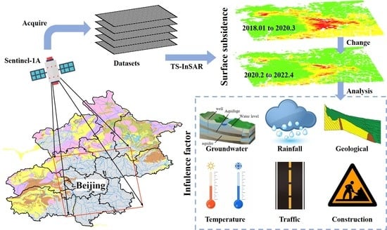
Surface Subsidence Characteristics and Causes in Beijing (China) before and after COVID-19 by Sentinel-1A TS-InSAR

1
College of Geomatics and Geoinformation, Guilin University of Technology, Guilin 541004, China
2
School of Municipal and Surveying Engineering, Hunan City University, Yiyang 413000, China
3
Geoscience and Survey Engineering College, China University of Mining and Technology-Beijing, Beijing 100083, China
*
Author to whom correspondence should be addressed.
Remote Sens. 2023, 15(5), 1199; https://doi.org/10.3390/rs15051199
Submission received: 9 January 2023 / Revised: 9 February 2023 / Accepted: 20 February 2023 / Published: 22 February 2023
(This article belongs to the Special Issue Applications of SAR Images for Urban Areas)

Abstract

:
Surface subsidence is a serious threat to human life, buildings and traffic in Beijing. Surface subsidence is closely related to human activities, and human activities in Beijing area showed a decreasing trend during the Corona Virus Disease 2019 (COVID-19). To study surface subsidence in Beijing before and after the COVID-19 outbreak and its causes, a total of 51 Sentinel-1A SAR images covering Beijing from January 2018 to April 2022 were selected to derive subsidence information by Time Series Interferometry Synthetic Aperture Radar (TS-InSAR). The results of surface subsidence in Beijing demonstrate that Changping, Chaoyang, Tongzhou and Daxing Districts exhibited the most serious subsidence phenomenon before the COVID-19 outbreak. The four main subsidence areas form an anti-Beijing Bay that surrounds other important urban areas. The maximum subsidence rate reached −57.0 mm/year. After the COVID-19 outbreak, the main subsidence area was separated into three giant subsidence funnels and several small subsidence funnels. During this period, the maximum subsidence rate was reduced to −43.0 mm/year. Human activity decrease with the COVID-19 outbreak. This study effectively analysed the influence of natural factors on surface subsidence after excluding most of the human factors. The following conclusions are obtained from the analysis: (1) Groundwater level changes, Beijing’s geological structure and infrastructure construction are the main reasons for surface subsidence in Beijing. (2) Seasonal changes in rainfall and temperature indirectly affect groundwater level changes, thereby affecting surface subsidence in the area. (3) The COVID-19 outbreak in early 2020 reduced the payload of Beijing’s transportation facilities. It also slowed down the progress of various infrastructure construction projects in Beijing. These scenarios affected the pressure on the soft land base in Beijing and reduced the surface subsidence trend to some extent.

Graphical Abstract

1. Introduction

Surface subsidence, one of the most common global geological disasters, is characterised by a long duration and a wide subsidence range; this phenomenon is difficult to reverse [1,2]. Every surface subsidence disaster can seriously affect the safety of people’s lives and social infrastructure [3,4]. Surface subsidence occurs in more than 150 regions worldwide, such as the North China Plain, the Yangtze River Delta, California, the Mexican Basin and the Iran Plain [5,6,7,8,9]. In the context of many accelerated urbanisation processes worldwide, using effective monitoring technology to obtain surface deformation information and spatiotemporal evolution laws timely has great practical relevance [10].
After reform and development, China has experienced unprecedented large-scale urbanisation development. Severe subsidence occurs in most economically developed cities, such as Beijing, Wuhan, Shanghai, Guangzhou, Shenzhen and Kaohsiung [11,12,13,14,15,16]. The area of subsidence in Beijing, one of the cities with the most severe subsidence phenomenon in China, has been expanding since 1950 [17]. The total area of subsidence is now more than one-third of Beijing. Beijing is not only the capital of China but also the country’s economic centre and foreign exchange centre. By 2021, it had a resident population of more than 21.886 million and an annual gross regional product exceeding RMB 4026.96 billion. Therefore, the surface subsidence in Beijing must be continuously observed and analysed, and a reference for surface subsidence hazard prevention and control in other cities must be provided [18].
At present, many methods are applied to surface deformation monitoring, mainly including precision levelling, global navigation satellite system measurement (GNSS), InSAR and other techniques [10,19,20,21].
In recent years, surface deformation monitoring technology by InSAR has shown the characteristics of low cost and high efficiency; it is widely used for surface subsidence monitoring, landslide monitoring and deformation monitoring of infrastructure (airports, buildings, roads, railways and bridges) [22,23,24,25]. Differential InSAR (D-InSAR) acquires deformation information based on a single interferogram and can acquire surface deformation information with centimetre-level accuracy; this technique presents results within the permissible error range for large-area deformation monitoring [26,27]. It also has the advantage of acquiring data in all weather conditions; thus, it has been widely used for surface subsidence monitoring [28]. However, the effectiveness of applying the D-InSAR technique often depends on uncertainties, such as spatiotemporal decorrelation and atmospheric delays; thus, the accuracy of this technique for topographic variation monitoring is reduced [4]. Scholars aim to reduce the limitations of the D-InSAR technique; thus, they proposed various time series InSAR techniques for long-time and wide-range deformation monitoring, such as PS-InSAR, small baseline subset InSAR (SBAS-InSAR) and distributed scatterer InSAR (DS-InSAR) [29]. PS-InSAR can solve the problems of spatiotemporal decorrelation and atmospheric delays and obtain surface deformation information conveniently and efficiently, and it has become one of the mainstream deformation monitoring techniques [30,31].
The four leading causes of surface subsidence include exploitation of groundwater resources, karst collapse, mining of solid minerals and engineering construction [27]. Beijing, a megacity with severe water shortage, relies on groundwater extraction for one-third of its water supply; the most apparent manifestation of excessive groundwater extraction is severe surface subsidence [32,33]. The surface subsidence process in Beijing is divided into four stages: the formation stage (1955–1973), the development stage (1974–1983), the expansion stage (1984–1998) and the rapid development stage (1999–present) [34]. Thus far, many studies on Beijing have been conducted. The research methods and data are slightly different. However, they all point to the overexploitation of groundwater as the main cause of surface subsidence [35]. Zhu et al. [15] used a Back Propagation Neural Network to reverse the general trend of surface subsidence in Beijing; they concluded that groundwater table changes are the most considerable influencing factor of surface subsidence. Gao et al. [36] used wavelet transform to analyse the relationship between the time series of surface subsidence changes and groundwater changes in the eastern Beijing plain; the results showed that the time series of surface subsidence changes lags behind that of groundwater level changes. Guo et al. [37] used the SBAS-InSAR technique to obtain surface subsidence models for Beijing from November 2014 to July 2018 whilst using the seismic frequency resonance method to obtain the profile data of some subsidence areas, which can assist in the analysis; they concluded that the surface subsidence in Beijing begins to show a slowing trend. Lei et al. [38] obtained information on surface deformation in Beijing from 2013 to 2018 using RadarSAT-2 impacts from 54 views covering the Beijing Plain; their study showed that surface subsidence was mainly concentrated in the eastern, northern and southern regions of the Beijing Plain, whereas groundwater funnels in the second and third confined aquifers are largely consistent with surface subsidence.
COVID-19 appeared in the winter of 2019 and broke out in spring 2020. During the early months of the COVID-19 outbreak, Beijing was subjected to severe lockdown measures (e.g., stay-at-home orders, regional lockdowns and travel restrictions) [39,40]. For a considerable period of time, construction in Beijing was greatly impeded. Lockdown measures restricted human activity, causing extensive social and economic anomalies worldwide [41,42]. Chen et al. utilized high-temporal planet multispectral images to detect traffic density in multiple cities through a morphology-based vehicle detection method [40]. Macioszek et al. extracted road traffic volume in Gliwice (Poland) before and during COVID-19 through video remote sensing [41]. Their results showed when the COVID-19 outbreak occurred, the traffic density significantly declined, which indicated that the local residents were positively exercising social distancing. However, the analysis about surface subsidence in Beijing before and after the COVID-19 outbreak is little. In order to compare and analyse the spatial–temporal evolution and causes of subsidence in the Beijing area before and after the outbreak of COVID-19, we used the TS-InSAR to obtain the deformation information covering the Beijing Plain from January 2018 to April 2022 in this study. To investigate the impact of natural environment on surface subsidence in Beijing, we obtained information on the burial depth variation of groundwater and geological formations in Beijing. In addition, the rainfall data and temperature change information from the Beiyuan Street Weather Monitoring Station in Beijing were used to assist in analysing the causes of surface subsidence in Beijing. In considering the effect of human activities (such as infrastructure construction and traffic volume) on surface subsidence, we used remote sensing imagery to observe the Beijing–Harbin Expressway.
The paper is organised as follows: Section 2 provides information on the study area and data. Section 3 describes, in detail, the method of acquiring surface deformation information via the PS-InSAR technique. Section 4 analyses the characteristics of the spatial distribution of the acquired surface subsidence rate field and the time series characteristics of surface subsidence in Beijing. In Section 5, we focus on the relationship between groundwater level changes and surface subsidence through the grey relational analysis (GRA) method. The influence of geological formations on the surface subsidence in Beijing is analysed, and the causes of surface subsidence changes in Beijing are investigated with the aid of rainfall information and temperature information in Beijing. Conclusions are provided in Section 6.

2. Study Area and Datasets

2.1. Study Area

Beijing (115°42′E to 117°24′E, 39°24′N to 41°36′N) has a total area of approximately 16,410.54 km2 (Figure 1). Beijing is in the northern part of the North China Plain. It has a temperate monsoon climate with a relatively flat topography and an average altitude of 43.5 m above sea level. The Jundu Mountains, which belong to the Yanshan system, are in northern Beijing. The Xishan Mountains, which belong to the Taihang system, can be found on Beijing’s west. The plain area is a prehill alluvial plain formed by the combined action of several rivers, including the Yongding, Chaobai, Wenyu and Ju Rivers. Several areas with severe subsidence exist in the plain [39].
The geological structure of Beijing is relatively simple. Its main urban areas are dominated by loose rock types, which are porous and have good soil moisture mobility. Given the accelerated urban expansion of Beijing, many construction projects have led to an increase in surface loading. Moreover, various factors, including the overexploitation of groundwater resources caused by residential water and industrial production water, have led to abnormal surface subsidence in Beijing. The Beijing Municipal Commission of Planning and Natural Resources has successively issued the ‘Technical Guidelines for the Implementation of Geological Disaster Management Projects in Beijing (Trial)’, the ‘Guidelines for Emergency Investigation on Abrupt Geological Hazards in Beijing (Trial)’ and other related technical specifications to strengthen the prevention and control of surface subsidence and its associated geological disasters in Beijing.

2.2. Datasets

The 51-scene ascending SAR images processed in this study are from the Sentinel-1A satellite launched by the European Space Agency (ESA). This satellite carries a C-band SAR antenna with a revisit period of 12 days, allowing effective monitoring of small ground deformations. The 51-scene SAR images span from January 2018 to April 2022, with a graphical acquisition interval of 1 month. The specific parameters of the images are shown in Table 1.
The 3-arc-second Shuttle Radar Topography Mission (SRTM) DEM provided by the National Aeronautics and Space Administration (NASA) was adopted to remove topographic phases. The Precise Orbit Determination (POD) released by ESA were used for orbit refinement. The groundwater level data were obtained from the website of Beijing Municipal Water Bureau. The meteorological data were obtained through the World Weather Network. The geological map was obtained from the Geoscience Data Sharing Network of the Chinese Academy of Geological Sciences. The optical image data were obtained from Google Earth Pro software. We analysed the above data to study the subsidence mechanism in the region.
We collected data from four groundwater monitoring stations (three groundwater monitoring stations in Tongzhou District and another groundwater monitoring station in the northern part of Daxing District) and one meteorological monitoring station in Beiyuan Street, Tongzhou. We obtained the rainfall data and temperature data through this weather station.

3. Method

We used the PS-InSAR technique for surface subsidence studies. In 2001, Ferretti proposed the PS-InSAR method, where the PS points were selected in the study area for surface deformation analysis [31]. These PS points can maintain high coherence for a long time, effectively reduce the spatiotemporal decorrelation effect, weaken the error component caused by atmospheric delay, facilitate long time series surface subsidence monitoring and maximise data utilisation [28,43].
Given the large amount of SAR data used in the present study, the extensive time span and the broad scope of the study area, we divided the 51 scenes covering Beijing into two groups for data processing to reduce the pressure of data processing and prevent the decoherence phenomenon. The specific process flow is as follows (Figure 2) [44,45,46,47,48].
  • Selecting the master image and aligning the image. The master image of the image set was selected by the method which integrated the coherence coefficient. If the N + 1 scene SAR images covering the same area are acquired, the images are arranged chronologically; the interference pair integrating the coherence coefficients of the vertical spatial baseline, temporal baseline and Doppler centroid frequency baseline amongst the images are solved; and the image with the largest coefficient value is optimally selected as the master image. The formula can be expressed as follows:
    ρ m = 1 K k 1 k { [ 1 B k , m B c ] × [ 1 T   k , m T c ] × [ 1 B ( D C ) k , m f c ] }
    where ρ m is the integrated coherence factor of the interferometric pair. B k , m , T   k , m and B ( DC ) k , m are the vertical spatial baseline, time baseline and Doppler centroid frequency baseline of the interferometric pair of image k and image m , respectively. B c , T c and f c are the critical conditions for each element. The homonymous image points were selected between the interference image pairs. The image registration was performed by polynomial correction transformation. The polynomial coefficients were solved by the least square method using the coordinate values of the homonymous image points. The results of this step are shown in Figure 3.
We divided the 51 images into two batches and processed the data separately. The first batch consisted of 26 scenes from January 2018 to March 2020, whereas the second batch comprised 27 scenes from February 2020 to April 2022, with a 2-month overlap between the two data sets. We selected the SAR images acquired on 16 April 2019 and 16 February 2021 as master images after calculation (Figure 3).
2.
Differential interference processing. We clearly found considerable noise in the VH polarisation intensity maps. In addition, the penetration of VV polarisation is stronger than that of VH polarisation. Thus, many PS points can be detected in the VV polarisation images. For the aforementioned reasons, we finally chose VV polarisation SAR images for the PS-InSAR data processing.
We used the N + 1 images covering the study area to obtain N interferometric pairs. After the topographic phase was eliminated using the 3-arc-second SRTM DEM, the flat-Earth effect phase was removed. The phases in the differential interferograms can be expressed as follows:
{ φ = φ ( d e f ) + φ ( a t m o ) + φ ( f l a ) + φ ( n o i s e ) φ ( d e f ) = 4 π λ Δ ( r k ) φ ( a t m o ) = 4 π λ ( σ k σ m )
where φ is the differential interference phase, φ ( def ) represents the deformation phase of the differential interferogram, φ ( atmo ) refers to the phase difference caused by the atmospheric delay, φ ( fla ) depicts the phase related to the flattened earth and φ ( noise ) denotes random noise phases [49]. Δ ( rk ) represents the deformation in the line-of-sight direction of the radar, and σ k and σ m are the atmospheric phases of image k and image m .
3.
Choosing the PS points. According to the strong reflection characteristics of PS points, we used the amplitude deviation index method to select the pixels with high amplitude values in the SAR images. Then, we obtained the PS points in the study area. The amplitude g l ( i , j ) of each pixel ( i , j ) in N + 1 SAR images was calculated:
g l ( i , j ) = R 2 ( i , j ) + I 2 ( i , j )
In Equation (3), R ( i , j ) and I ( i , j ) represent the real and virtual parts of the echo signal, respectively. The amplitude dispersion D is expressed as:
D ( i , j ) = s t d   g l ( i , j ) m e a n   g l ( i , j )
std   g l ( i , j ) denotes the standard deviation of   g l ( i , j ) , and mean   g l ( i , j ) is the average of   g l ( i , j ) . A threshold value T was set during data processing. When D ( i , j ) T , the corresponding pixel is determined as a PS point.
4.
Achieving surface deformation information. The first step is phase unwrapping. The phase difference obtained from the interferogram is only the principal value in the range of ( π , + π ) . Phase unwrapping is the process of recovering the phase principal value to the real phase difference. This step is crucial in InSAR data processing. The quality of the phase unwrapping directly affects the quality of the final deformation result. The second step is to classify the unwrapped phase and judge whether the differential phase exceeds the threshold through dualistic linear regressive analysis. If the threshold value is not exceeded, the deformation rate can be directly obtained through linear deformation. If the threshold value is exceeded, the residual phase is filtered by a high-pass filter in time and a low-pass filter in space. Then, the nonlinear deformation estimation value and atmospheric phase are obtained [50]. After spatiotemporal filtering and atmospheric phase removal, the linear and nonlinear transformations are summed to obtain the complete surface deformation information [51].
5.
Results validation. In order to assess the result of PS-InSAR, we calculated the quality index for accuracy assessment, which is the ratio of the mean value to the standard deviation (the mean value is the average value over time).

4. Results

4.1. Surface Subsidence Results in Beijing

The surface subsidence rate field and subsidence time series in Beijing area from January 2018 to April 2022 were obtained by the PS-InSAR technique based on the 51-scene Sentinel-1A SAR images. The first batch of these results runs from January 2018 to March 2020 (before the COVID-19 outbreak) and the second batch from February 2020 to April 2022 (after the COVID-19 outbreak). Figure 4 and Figure 5 show the surface subsidence rate maps of Beijing in the two periods obtained in this study. Figure 6 and Figure 7 show the time series of the cumulative surface subsidence in Beijing from January 2018 to March 2020 and from February 2020 to April 2022, respectively. The green area in the figure indicates that the subsidence is relatively stable, whereas the dark red area denotes that the subsidence is relatively severe.
As shown in Figure 4, the overall subsidence in Beijing before the COVID-19 outbreak is relatively large, with an average subsidence rate of −13.5 mm/year and a median of −12.7 mm/year. The four considerable subsidence areas are in Changping, Chaoyang, Tongzhou and Daxing Districts, with the four subsidence areas joining together to form the anti-Beijing Bay (black curve in Figure 4). The four major subsidence areas join together to form an anti-Beijing Bay [52], which encircles important urban areas, such as the downtown, Haidian and Fengtai District. The largest subsidence trend is in Tongzhou, with a maximum subsidence rate of −57.0 mm/year.
As shown in Figure 5, the subsidence phenomenon in Beijing area after the COVID-19 outbreak is still severe. However, the subsidence trend slows down slightly, and the subsidence range decreases. The maximum subsidence rate in Beijing area drops to −43.0 mm/year. The average and median rates are −6.7 and −6.3 mm/year, respectively. The anti-Beijing Bay subsidence area is separated into three large subsidence funnels, namely, Tongzhou, Chaoyang and Changping. Daxing area is separated into several small subsidence funnels.
The comparison of Figure 6 and Figure 7 shows that the subsidence range in Beijing gradually expanded before the COVID-19 outbreak, accompanied by the merging trend of the four main subsidence areas of Changping, Chaoyang, Tongzhou and Daxing. The maximum cumulative subsidence is −124.1 mm, located in Tongzhou. The subsidence range in the study area after the COVID-19 outbreak decreases. However, the subsidence phenomenon is still serious in the area where subsidence occurs, with the maximum subsidence reaching −98.6 mm. The subsidence in other urban areas is generally not substantial, with the subsidence of most PS points not exceeding −5 mm. Thus, the subsidence in these areas is judged to be less severe than that in other areas.

4.2. Precision Verification of the Subsidence Results

The surface subsidence information in Beijing area from January 2018 to April 2022 was derived by the PS-InSAR using the 51-scene Sentinel-1A SAR images covering the study area. Over one million PS points were obtained through two data processing sessions. We randomly sampled 300,000 points from these points to efficiently assess the internal precision of the surface subsidence information obtained by the PS-InSAR technique by calculating the quality index for accuracy assessment, which is the ratio of the mean value to the standard deviation. The mean value is the average value over time (Figure 8).
In Figure 8a, points account for 93.80% of the total, with quality better than 10.0 mm/year. In Figure 8b, points account for 94.14% of the total, with quality better than 10.0 mm/year. Finally, the median quality of the two-batch data processing results was 4.61 and 4.60 mm/year. This finding shows that the surface subsidence results in Beijing obtained from the Sentinel-1A ascending rail data processed in this study are highly accurate.
In this study, we derived the surface subsidence in Beijing area from 2018 to 2022. To study the early surface subsidence and compare them with our results, we summarized the results of previous studies on surface subsidence monitoring in Beijing, as shown in Table 2.
Five major subsidence areas were formed in Beijing between 2003 and 2010 (Changping, Shunyi, Chaoyang, Tongzhou and Daxing) [53]. Yang et al. analysed surface subsidence in Beijing from 2003 to 2016, and they found that two massive subsidence funnels were mainly distributed in the eastern part of Chaoyang District, with the maximum subsidence rate exceeding −150 mm/year [50]. From 2003 to 2020, the Beijing surface subsidence rate continued to accelerate [50,54]. Subsidence in Beijing area still had five subsidence centres from 2017 to 2020, but the subsidence trend started to slow down after 2018 [18]. Between 2015 and 2021, the Chaoyang and Tongzhou subsidence areas developed as a whole with a wide spatial coverage [55]. The previous studies were able to identify similar subsidence funnels and subsidence rate, although they used different datasets and methods for surface subsidence monitoring. Compared with the results of previous studies, the spatial distribution of the subsidence area detected in this study is consistent with the previous results.

5. Discussion

5.1. Correlation Analysis between Groundwater Level Changes and Subsidence Time Series

In this study, the groundwater level change data were obtained from four groundwater level monitoring wells in Beijing, which are in the Tongzhou and Daxing Districts (Figure 9). Well (a) is the Zhangjiawan Gate Station located at Zhangcai Road, Tongzhou District, on the northern bank of the Liangshui River. Well (b) is in Haojiafu, Canal East Street, Tongzhou District, which is a metro station on Metro Line 6. Well (c) is in the eastern Yizhuang Wetland, which is not only the junction of Tongzhou and Daxing Districts but also the intersection of Metro Line 17 and Yizhuang Line. Well (d) is located at the intersection of Sunbo Road and Guiguo Road in Daxing District. Sunjia Industrial Park is in this area, where many factories with high water consumption, such as paper mills, printing plants and grease factories are located.
Beijing gained a large external population in its development. To ensure an adequate supply of domestic and industrial water, a large amount of groundwater was continuously exploited. However, groundwater levels are rapidly lowering, and significant surface subsidence is occurring. In an attempt to analyse the relationship between groundwater level changes and surface subsidence, we selected groundwater level change data from groundwater level observation wells from September 2021 to April 2022. We extracted the average cumulative surface subsidence within 200 m around the groundwater monitoring station for comparative analysis. The comparative analysis results of the groundwater level change (black line) and subsidence time series change (red line) are shown in Figure 10.
Figure 10a–c show that when the groundwater level drops, the surface shows remarkable subsidence. The surface also shows a slowing down of the subsidence trend or a slight uplift when the groundwater level drop slows down or rebounds. A lag between surface subsidence and groundwater level decline can be observed in Figure 10b. The monitoring data from well (b) show that groundwater levels began to decline around the beginning of October 2021 and returned to a plateau by the end of January 2022; the surface in this area began to settle in mid-November 2021 and returned to a plateau by mid-February 2022. This finding indicates that surface subsidence in this area lags behind groundwater level changes by approximately 40 days. Figure 10d shows the seasonal variation of groundwater level in Sunjia Industrial Park in Daxing District. The water level in winter 2021 was substantially higher than that in autumn 2021 and spring 2022. The surface subsidence trend slowed down during this period, followed by a lag of approximately 30–40 days before the uplift began. Finally, we found that when the groundwater level in the area dropped, surface subsidence immediately existed, indicating that the surface in this area was sensitive to the drop in water level with a low lag. In addition, we adopted the GRA method to calculate the relationship between subsidence and water level time series. The GRA were obtained as follows: 0.76 for well (a), 0.56 for well (b), 0.79 for well (c) and 0.72 for well (d). They can demonstrate that the changes in subsidence may be closely related to those of the water level.

5.2. Analysing the Effect of Seasonal Variation in Rainfall on Surface Subsidence Time Series

We obtained the meteorological data in Beiyuan Street, Tongzhou District, and the PS points for subsidence within 200 m of the meteorological station (shown in Figure 11) to analyse the relationship between rainfall and surface subsidence in Beijing area. Given that the PS points selected by the two data processes are different, the PS points are also different.
The rainfall in the region before the COVID-19 outbreak is much less than after the COVID-19 outbreak (Figure 11a,c). This finding shows that 2018 and 2019 are relatively dry years, whereas 2020 and 2021 are abundantly wet years. Rainfall infiltrates from the surface into the soil. Then, it replenishes groundwater and can directly affect changes in groundwater levels. Finally, it indirectly affects the surface subsidence phenomenon. The rainfall between 2018 and 2019 was very little. The lack of groundwater replenishment in the area inevitably leads to surface subsidence. When rainfall was abundant in 2020 and 2021, groundwater was effectively replenished, and the foundations were strongly supported. Thus, the trend of surface subsidence slowed down.
Figure 11c shows that rainfall varies seasonally, and the ground surface exhibits a seasonal subsidence trend. The flood season in Beijing is between May and October. Thus, the subsidence trend in the area around Beiyuan Street slows down. By contrast, surface subsidence increases within a dry period. As illustrated in Figure 11c, the surface subsidence is serious from October 2020 to May 2021 and November 2021 to January 2022. The results show that a negative correlation exists between rainfall and ground subsidence; in particular, the high rainfall amount slows down the ground subsidence trend or even shows a slight uplifting trend. This finding indicates that rainfall takes some time to collect into surface runoff and infiltrate through the soil into the subsurface runoff. With the rise of the groundwater level and the increase in the soil water content, the support of bedrock was improved, thus effectively slowing down the surface subsidence trend and reducing the surface subsidence rate [54,56]. The change in surface deformation lags behind the change in rainfall, and the lag time is longer than that of surface deformation and groundwater.

5.3. Analysis of the Influence of Geological Structure on Subsidence

To research the relationship between geological formations and local surface subsidence in Beijing, we downloaded a geological map and cross-section of Beijing for analysis. Many kinds of aquifer groups are distributed in Beijing, and the spatial distribution of these different aquifer groups is evident (Figure 12). Jundu Mountain and Xi Mountain are in the north and west of Beijing, respectively. In the mountain area, many kinds of rock aquifer groups are distributed alternately. However, the central, eastern and southern plain areas are dominated by loose bed porous aquifer group.
From the Xi Mountain in the west to the Great Plains in the southeast, the thickness of this loose rock pore-bearing formation deepens from a few metres to several hundred metres. The Beijing Plain area is a piedmont alluvial-proluvial plain influenced by rivers. The plain soil is horizontally distributed; from the foothills to the plain, it is successively cinnamon soil, carbonate cinnamon soil, tidal soil and marshy soil. The tidal soils and swampy soils in the plain have high water content and soft texture. The pore water pressure in the rock and soil layers in the Beijing area is slow to dissipate, and the release of water lags, thereby causing the subsidence to lag slightly behind rainfall [57].
Yongding River, Chaobai River, Wenyu River, Ju River and other rivers are in Beijing. They belong to the Haihe and Ji Canal systems. Given the uneven rainfall, these rivers vary greatly from season to season, with high flows in the summer and low flows in the winter. They even dry up in some extremely dry years. These natural conditions result in a lack of water retention capacity in the Beijing plain, making replenishing groundwater in time difficult when the groundwater level drops, ultimately leading to severe surface subsidence.
We analysed the causes behind the local distribution of subsidence rates based on the geological formations in Beijing (shown in Figure 13a,b). In the western and northern mountainous areas, decorrelation is prone to occur because of landslides, mudslides, rockfalls, tree growth and collapse. Figure 13 shows that no PS points exist in the mountainous areas (other geological rock formations) of Beijing, whereas a large number of subsidence points exist in plain areas (where loose bed porous aquifer groups are distributed).
We find that a clear demarcation exists between the areas of Beijing where the surface subsidence rate is greater than −5 mm/year and the areas where it is less than −5 mm/year (Figure 13). The boundary is approximately 5 km west of Maju Bridge (Figure 12b), which is also a boundary where the rock groups disappear (the carbonate rock aquifer group, the fragmental rocks with carbonate rock aquifer group and the fragmental rock aquifer group). This finding indicates that these three rock groups have a certain degree of containment effect on surface subsidence because the carbonate rock aquifer groups in Beijing are mainly limestone, which is a very strong rock. The fragmental rock aquifer group are mainly sandy shale and sandy clay, which are moderately strong rocks. The rock formations in this area are also relatively thick. Thus, the surface subsidence is low. These groups gradually disappear, and the loose bed porous aquifer group dominates in the subsequent area. The loose bed porous aquifer group in the area mainly includes sandy cobble, sand, sandy clay and clayey sandy, which tend to be highly porous in general. Given the rapid development of Beijing, many infrastructures have been built on the surface of the area in a short period and there is a huge volume of traffic on a daily basis, thereby creating great pressure on the strata and aggravating the surface subsidence phenomenon.

5.4. Temperature Effects on Surface Subsidence Times Series

In order to analyse the image of rainfall on surface subsidence, we accessed the rainfall data for Beiyuan Street in Tongzhou District, Beijing, with a temporal resolution of 24 h. We also established a 200 m buffer zone around Beiyuan Street to filter out the information on the subsidence rate within the range (Figure 11b,d). The average cumulative amount of surface subsidence in this area was calculated. Then, the linear trend was removed, leaving the volatility of the time series (presented in Figure 14).
Beijing’s climate is a medium latitudes monsoon, with hot and rainy summers and cold and dry winters; the characteristic is simultaneous rain and heat. As illustrated in Figure 14b, rainfall is extremely low during the low-temperature period, groundwater is not effectively replenished, and the surface subsidence trend in the region ultimately intensifies. We found that the surface subsidence in 2018 and 2019 was much greater than that in 2020 and 2021 (Figure 11a,c) because of the rainfall and groundwater levels on surface subsidence. The details are described in Section 5.1 and Section 5.2.
We also found that the fluctuations in surface deformation are greater when the ground temperature changes (i.e., during an increase or decrease in temperature) because of the heat exchange between air, soil and groundwater. Moreover, the changes in temperature gradients cause changes in energy gradients. Then, a change in potential energy occurs between soil water and groundwater, eventually leading to a vertical exchange of soil water and groundwater [58]. Beijing Plain is dominated by a loose bed porous aquifer group, which facilitates the vertical flow between soil water, fractured water and groundwater. For short-term temperature changes throughout the day, the ground receives heat transfer to the soil in the morning when the temperature rises, and an upward potential energy gradient occurs. Water flows downwards to replenish groundwater. In the evening, when the temperature falls, the direction of water movement is upwards, and the groundwater evaporates. For seasonal changes in temperature throughout the year, the soil water and fracture water recharged to groundwater dominate during the warming season, and the groundwater levels rise. During the cooling season, groundwater evaporation dominates, and groundwater levels fall. Seasonal changes in temperature can lead to seasonal changes in groundwater levels and changes in groundwater-carrying capacity. They affect the stability of the ground surface and lead to seasonal deformation of the ground surface.

5.5. Human Activities Affect Subsidence before and after the COVID-19 Outbreak

To study the effect of traffic on subsidence before and after the COVID-19 outbreak, we analysed the Beijing–Harbin Expressway (code G1) as an example. The G1 is one of the radial motorways of China’s capital. Its construction started in September 1996 and was completed in September 2000. The Beijing section of the G1 begins in Chaoyang District and ends in Tongzhou District, with a total length of approximately 41 km. According to public information from the Beijing Municipal Commission of Housing and Urban–Rural Development, the roadway widening on this section began in 2019. We extracted information on the surface subsidence rate in the vertical direction for 600 m around the Beijing section of the G1 (Figure 15).
The subsidence trend on this motorway slowed down substantially after 2020 (Figure 15) for two main reasons. On the one hand, it was influenced by the changes in groundwater levels and rainfall, as explained in detail in Section 5.1 and Section 5.2. On the other hand, it was influenced to a large extent by the COVID-19 outbreak. After the COVID-19 emergence, Beijing not only strictly controlled the movement of people between the city and outside the city but also suspended the construction of many infrastructure projects. The reduced movement of people led to a reduced traffic pressure on G1, effectively decreasing the vehicle load on that highway. The suspension of infrastructure construction reduced the pressure on the soft ground beneath. Therefore, COVID-19 indirectly reduced the surface subsidence trend in Beijing. Long-term ground loading is an important influence on ground subsidence.
The Wufang Bridge, located within the Chaoyang District, is an interchange between the G1 and the Beijing East 5th Ring Road. The Shiyuan Bridge, located within the Tongzhou District, is an interchange between the G1 and the Beijing East 6th Ring Road. The diagram shows that the subsidence of the Shiyuan Bridge is much greater than that of the Wufang Bridge (Figure 15). The major reasons for this situation include the continued rapid development of Beijing and the influx of many people into the city. The increasing congestion on the main traffic routes in and around Wufangqiao results in an increased load on the bridge. Eventually sustained pressure was exerted on the land beneath the bridge and visible ground subsidence occurred.
In the first and second periods, the most severe area of subsidence in this highway section is located between 14 and 16 km, approximately 3 km from the Shiyuan Bridge. In the vertical projection direction, the maximum subsidence rate from January 2018 to March 2020 is −86.2 mm/year, with a maximum cumulative subsidence of −185.7 mm. The maximum subsidence rate from February 2020 to April 2022 is −46.6 mm/year, with maximum subsidence of −195.9 mm/year. We found a bridge construction underway in this area through remote sensing images (Figure 16).
This interchange started construction at the end of 2019 to connect Wenjing East Street with the Beijing–Harbin Expressway. The construction area is missing the PS point from Figure 16b,c, as the ground subsidence in the construction area is too severe and out of phase. We extended the observation to reflect the subsidence indirectly in the construction area by the surface subsidence around the construction area. The construction of the interchange started in late 2019. It was largely completed by early 2021. The average surface subsidence around the construction period reached −48 mm, and the maximum surface subsidence reached −83.2 mm. These findings indicate that frequent ground loading and infrastructure construction are crucial causes of the surface subsidence phenomenon during long-term urban development.

6. Conclusions

In this paper, to compare and analyse the spatial–temporal evolution of subsidence before and after the outbreak of COVID-19, we first used the TS-InSAR technique to obtain information on the long-term surface subsidence in Beijing area in the last four years. The spatial–temporal characteristics of the surface subsidence in the periods before and after the complete outbreak of COVID-19 were analysed. Then, we considered the natural factors for the seriousness of subsidence in Beijing, for example, groundwater, rainfall, temperature and geological structure. Finally, the effect of human activities on surface subsidence was analysed in the context of traffic and infrastructure construction. The main conclusions are as follows:
  • Subsidence in Beijing before the COVID-19 outbreak was remarkably more severe than that after the COVID-19 outbreak. Prior to the COVID-19 outbreak, several large subsidence funnels tended to merge. The subsidence zone formed an envelope around the city centre at the maximum subsidence rate of −57.0 mm/year. The area of subsidence zones slightly reduced after the complete outbreak of COVID-19. The major subsidence area was separated into three giant subsidence funnels and several small subsidence funnels. The subsidence rate during this period was slightly reduced to a maximum of −43.0 mm/year.
  • Natural factors that mainly affect surface subsidence in Beijing area are groundwater, rainfall, geological formations structure and temperature. Four groundwater level monitoring wells showed a strong correlation between groundwater and surface deformation. Beiyuan Street was used as an illustration, and the findings indicated that changes in rainfall and temperature affect groundwater level changes in the area. Declining groundwater levels reduce the surface carrying capacity of the area, and surface subsidence occurs. These findings indicate that groundwater level changes directly affect the surface subsidence trend, whereas rainfall and temperature indirectly affect surface subsidence. An analysis of the spatial characteristics of surface subsidence reveals that surface subsidence is severe in the plains because the loose bed porous aquifer group has a large number of spaces.
  • The survey of the G1 with remote sensing images revealed that human activities is also a considerable contributor to surface subsidence. Beijing traffic decreased and infrastructure construction was suspended after the COVID-19 outbreak. This scenario reduced the pressure on the soft ground along the road and slowed down the tendency for surface subsidence. The results show that human activities (such as infrastructure construction and traffic volume) are reduced due to the impact of COVID-19, thus affecting the surface subsidence in Beijing area.

Author Contributions

H.S., L.Z. and C.H. conceived and designed the experiments; S.M. and L.X. carried out the data acquisition; H.S. and L.Z. performed data processing and analyses; H.S., L.Z. and F.Y. discussed and analysed the experimental results; Y.C. proofread the manuscript. All authors have read and agreed to the published version of the manuscript.

Funding

This research was funded by the National Natural Science Foundation of China (Grant No.42264004); the Guangxi universities’ 1000 young and middle-aged backbone teachers training program; the Natural Science Foundation of Hunan province of China (Grant No. 2021JJ30076); and the Foundation of Hunan educational committee (Grant No. 21A0502).

Data Availability Statement

Data incorporated in this research are available for free through the these webpages: Sentinel-1A (https://scihub.copernicus.eu/dhus/#/home, accessed on 15 April 2022); groundwater level data (swj.beijing.gov.cn, accessed on 10 June 2022); weather data (https://rp5.ru, accessed on 11 June 2022); 30 m SRTM DEM (http://dwtkns.com/srtm30m/, accessed on 16 April 2022); 90 m SRTM DEM (https://www.gscloud.cn/search, accessed on 9 June 2022); satellite POD (https://scihub.copernicus.eu/dhus/#/home, accessed on 15 April 2022). The optical image data were obtained from Google Earth Pro software, Geological map (http://www.geoscience.cn/UploadFiles/2016_10_28/hgm24.JPG, accessed on 13 June 2022).

Acknowledgments

We are grateful to the European Space Agency for providing the Sentinel-1A data and POD data for free.

Conflicts of Interest

The authors declare no conflict of interest.

References

  1. Umarhadi, D.A.; Avtar, R.; Widyatmanti, W.; Johnson, B.A.; Yunus, A.P.; Khedher, K.M.; Singh, G. Use of multifrequency (C-band and L-band) SAR data to monitor peat subsidence based on time-series SBAS InSAR technique. Land Degrad. Dev. 2021, 32, 4779–4794. [Google Scholar] [CrossRef]
  2. Zhou, B.; Li, X.; Li, Y. The advance of characteristics and research methods of land subsidence in the plain of Beijing and consideration for it. China Min. Mag. 2014, 23, 51–56. [Google Scholar]
  3. Macchiarulo, V.; Milillo, P.; DeJong, M.J.; Gonzalez, M.J.; Sanchez, J.; Giardina, G. Integrated InSAR monitoring and structural assessment of tunnelling-induced building deformations. Struct. Control. Health Monit. 2021, 28, e2781. [Google Scholar] [CrossRef]
  4. Guo, J.; Zhou, L.; Yao, C.; Hu, J. Surface Subsidence Analysis by Multi-Temporal InSAR and GRACE: A Case Study in Beijing. Sensors 2016, 16, 1495. [Google Scholar] [CrossRef] [Green Version]
  5. Sorkhabi, O.M.; Nejad, A.S.; Khajehzadeh, M. Evaluation of Isfahan City Subsidence Rate Using InSAR and Artificial Intelligence. KSCE J. Civ. Eng. 2022, 26, 2901–2908. [Google Scholar] [CrossRef]
  6. Li, J.; Zhou, L.; Ren, C.; Liu, L.; Zhang, D.; Ma, J.; Shi, Y. Spatiotemporal Inversion and Mechanism Analysis of Surface Subsidence in Shanghai Area Based on Time-Series InSAR. Appl. Sci. 2021, 11, 7460. [Google Scholar] [CrossRef]
  7. Neely, W.R.; Borsa, A.A.; Burney, J.A.; Levy, M.C.; Silverii, F.; Sneed, M. Characterization of groundwater recharge and flow in California’s San Joaquin Valley from InSAR-observed surface deformation. Water Resour. Res. 2021, 57, e2020WR028451. [Google Scholar] [CrossRef]
  8. Du, Z.; Ge, L.; Ng, H.-M.A.; Zhu, Q.; Zhang, Q.; Kuang, J.; Dong, Y. Long-term subsidence in Mexico City from 2004 to 2018 revealed by five synthetic aperture radar sensors. Land Degrad. Dev. 2019, 30, 1785–1801. [Google Scholar] [CrossRef]
  9. Guo, H.; Bai, J.; Zhang, Y.; Wang, L.; Shi, J.; Li, W.; Zhang, Z.; Wang, Y.; Zhu, J.; Wang, H. The evolution characteristics and mechanism of the land subsidence in typical areas of the North China Plain. Geol. China 2017, 44, 1115–1127. [Google Scholar]
  10. Zhang, S.; Zhang, Y.; Yu, J.; Fan, Q.; Si, J.; Zhu, W.; Song, M. Interpretation of the Spatiotemporal Evolution Characteristics of Land Deformation in Beijing during 2003–2020 Using Sentinel, ENVISAT, and Landsat Data. Remote Sens. 2022, 14, 2242. [Google Scholar] [CrossRef]
  11. Zhou, L.; Shi, X.; Ren, C.; Huang, Y.; Zhu, Z. Monitoring of land subsidence in Shenzhen reclamation area based on Sentinel-1A interferometric synthetic aperture radar. Sci. Technol. Eng. 2021, 21, 8765–8769. [Google Scholar]
  12. Dong, S.; Samsonov, S.; Yin, H.; Huang, L. Two-Dimensional Ground Deformation Monitoring in Shanghai Based on SBAS and MSBAS InSAR Methods. J. Earth Sci. 2018, 29, 960–968. [Google Scholar] [CrossRef]
  13. Zhou, L.; Guo, J.; Hu, J.; Li, J.; Xu, Y.; Pan, Y.; Shi, M. Wuhan Surface Subsidence Analysis in 2015–2016 Based on Sentinel-1A Data by SBAS-InSAR. Remote Sens. 2017, 9, 982. [Google Scholar] [CrossRef] [Green Version]
  14. Wang, H.; Feng, G.; Xu, B.; Yu, Y.; Li, Z.; Du, Y.; Zhu., J. Deriving Spatio-Temporal Development of Ground Subsidence Due to Subway Construction and Operation in Delta Regions with PS-InSAR Data: A Case Study in Guangzhou, China. Rmote Sens. 2017, 9, 1004. [Google Scholar] [CrossRef] [Green Version]
  15. Zhu, L.; Gong, H.; Li, X.; Li, Y.; Su, X.; Guo, G. Comprehensive analysis and artificial intelligent simulation of land subsidence of Beijing, China. Chin. Geogr. Sci. 2013, 23, 237–248. [Google Scholar] [CrossRef]
  16. Hsieh, C.; Shih, T.; Hu, J.; Tung, H.; Huang, M.; Angelier, J. Using differential SAR interferometry to map land subsidence: A case study in the Pingtung Plain of SW Taiwan. Nat. Hazards 2021, 58, 1311–1332. [Google Scholar] [CrossRef]
  17. Chen, B.; Gong, H.; Li, X.; Lei, K.; Gao, M.; Zhou, C.; Ke, H. Spatial-temporal evolution patterns of land subsidence with different situation of space utilization. Nat. Hazards 2015, 77, 1765–1783. [Google Scholar] [CrossRef]
  18. Zhang, S.; Xu, Q.; Lou, Y.; Lei, K.; Niu, Y.; Pang, X. Temporal and Spatial Variation of Land Subsidence in Beijing from 2017 to 2020 Interpreted by Time Series InSAR. J. Geod. Geodyn. 2022, 42, 48–53. [Google Scholar]
  19. Bai, Z.; Wang, Y.; Balz, T. Beijing Land Subsidence Revealed Using PS-InSAR with Long Time Series TerraSAR-X SAR Data. Remote Sens. 2022, 14, 2529. [Google Scholar] [CrossRef]
  20. Hamling, I.J.; Wright, T.J.; Hreinsdóttir, S.; Wallace, L.M. A snapshot of New Zealand’s dynamic deformation field from Envisat InSAR and GNSS observations between 2003 and 2011. Geophys. Res. Lett. 2022, 49, e2021GL096465. [Google Scholar] [CrossRef]
  21. Zhang, Y.; Gong, H.; Gu, Z.; Rong, W.; Li, X.; Zhao, W. Characterization of land subsidence induced by groundwater withdrawals in the plain of Beijing city, China. Hydrogeol. J. 2014, 22, 397–409. [Google Scholar] [CrossRef]
  22. Shi, X.; Chen, C.; Dat, K.; Deng, J.; Wen, N.; Yin, Y.; Dong, X. Monitoring and Predicting the Subsidence of Dalian Jinzhou Bay International Airport, China by Integrating InSAR Observation and Terzaghi Consolidation Theory. Remote Sens. 2022, 14, 2332. [Google Scholar] [CrossRef]
  23. Chen, Y.; Liao, M.; Wu, J.; Li, X.; Xiong, F.; Liu, S.; Feng, Y.; Wang, X. Elastic and Inelastic Ground Deformation in Shanghai Lingang Area Revealed by Sentinel-1, Leveling, and Groundwater Level Data. Remote Sens. 2022, 14, 2693. [Google Scholar] [CrossRef]
  24. Ge, W.; Li, Y.; Wang, Z.; Zhang, C.; Yang, H. Spatial-Temporal Ground Deformation Study of Baotou Based on the PS-InSAR Method. Acta Geol. Sin.-Engl. Ed. 2021, 95, 674–683. [Google Scholar] [CrossRef]
  25. Maubant, L.; Pathier, E.; Daout, S.; Radiguet, M.; Doin, M.-P.; Kazachkina, E.; Kostoglodov, V.; Cotte, V.; Walpersdorf, A. Independent component analysis and parametric approach for source separation in InSAR time series at regional scale: Application to the 2017–2018 slow slip event in Guerrero (Mexico). J. Geophys. Res. Solid Earth 2020, 125, e2019JB018187. [Google Scholar] [CrossRef]
  26. Lai, W.; Shen, Q.; Wang, H.; Shum, C.K.; Jiang, L.; Yang, B.; Dong, J.; Gao, F.; Zhao, Y.; Liu, T. InSAR-derived land subsidence in Wuhan between 2015 and 2020. All Earth 2022, 34, 224–242. [Google Scholar] [CrossRef]
  27. Zhao, Y.; Zhou, L.; Wang, C.; Li, J.; Qin, J.; Sheng, H.; Huang, L.; Li, X. Analysis of the Spatial and Temporal Evolution of Land Subsidence in Wuhan, China from 2017 to 2021. Remote Sens. 2022, 14, 3142. [Google Scholar] [CrossRef]
  28. Raucoules, D.; le Mouelic, S.; Carnec, C.; Maisons, C.; King, C. Urban subsidence in the city of Prato (Italy) monitored by satellite radar interferometry. Int. J. Remote Sens. 2003, 24, 891–897. [Google Scholar] [CrossRef]
  29. Zhu, J.; Li, Z.; Hu, J. Research Progress and Methods of InSAR for Deformation Monitoring. Acta Geod. Cartogr. Sin. 2017, 46, 1717–1733. [Google Scholar]
  30. Du, D.; Liu, H.; Zhou, J.; Zhang, J.; Miao, J.; Li, Y.; Cao, X.; Ye, M. Study of the characteristics and influencing factors of land subsidence in the Tongzhou district of Beijing. Acta Gcologica Sin. 2022, 96, 712–725. [Google Scholar]
  31. Ferretti, A.; Prati, C.; Rocca, F. Nonlinear subsidence rate estimation using permanent scatterers in differential SAR interferometry. IEEE Trans. Geosci. Remote Sens. 2000, 38, 2202–2212. [Google Scholar] [CrossRef] [Green Version]
  32. Ali, M.Z.; Chu, H.-J.; Tatas; Burbey, T.J. Estimation of annual groundwater changes from InSAR-derived land subsidence. Water Environ. J. 2022, 36, 622–632. [Google Scholar] [CrossRef]
  33. Zhu, L.; Gong, H.; Li, X.; Wang, R.; Chen, B.; Dai, Z.; Teatini, P. Land subsidence due to groundwater withdrawal in the northern Beijing plain, China. Eng. Geol. 2015, 193, 243–255. [Google Scholar] [CrossRef]
  34. Yang, Y.; Jia, S.; Wang, H. The Status and Development of Land Subsidence in Beijing Plain. Shanghai Land Resour. 2010, 31, 23–28. [Google Scholar]
  35. Chen, B.; Gong, H.; Li, X.; Lei, K.; Zhu, L.; Gao, M.; Zhou, C. Characterization and causes of land subsidence in Beijing, China. Int. J. Remote Sens. 2017, 38, 808–826. [Google Scholar] [CrossRef]
  36. Gao, M.; Gong, H.; Chen, B.; Li, X.; Zhou, C.; Shi, M.; Si, Y.; Chen, Z.; Duan, G. Regional Land Subsidence Analysis in Eastern Beijing Plain by InSAR Time Series and Wavelet Transforms. Remote Sens. 2018, 10, 365. [Google Scholar] [CrossRef] [Green Version]
  37. Guo, L.; Gong, H.; Li, J.; Zhu, L.; Xue, A.; Liao, L.; Sun, Y.; Li, Y.; Zhang, Z.; Hu, L.; et al. Understanding uneven land subsidence in Beijing, China, using a novel combination of geophysical prospecting and InSAR. Geophys. Res. Lett. 2020, 47, e2020GL088676. [Google Scholar] [CrossRef]
  38. Lei, K.; Ma, F.; Chen, B.; Luo, Y.; Cui, W.; Zhou, Y.; Liu, H.; Sha, T. Three-Dimensional Surface Deformation Characteristics Based on Time Series InSAR and GPS Technologies in Beijing, China. Remote Sens. 2021, 13, 3964. [Google Scholar] [CrossRef]
  39. Cai, Z.; Che, K.; Liu, Y.; Yang, D.; Liu, C.; Yue, X. Decreased Anthropogenic CO2 Emissions during the COVID-19 Pandemic Estimated from FTS and MAX-DOAS Measurements at Urban Beijing. Remote Sens. 2021, 13, 517. [Google Scholar] [CrossRef]
  40. Chen, Y.; Qin, R.; Zhang, G.; Albanwan, H. Spatial Temporal Analysis of Traffic Patterns during the COVID-19 Epidemic by Vehicle Detection Using Planet Remote-Sensing Satellite Images. Remote Sens. 2021, 13, 208. [Google Scholar] [CrossRef]
  41. Macioszek, E.; Kurek, A. Extracting Road Traffic Volume in the City before and during COVID-19 through Video Remote Sensing. Remote Sens. 2021, 13, 2329. [Google Scholar] [CrossRef]
  42. Baig, F.; Kirytopoulos, K.; Lee, J.; Tsamilis, E.; Mao, R.; Ntzeremes, P. Changes in People’s Mobility Behavior in Greece after the COVID-19 Outbreak. Sustainability 2022, 14, 3567. [Google Scholar] [CrossRef]
  43. Islam, M.R.; Abdel-Aty, M.; Islam, Z.; Zhang, S. Risk-Compensation Trends in Road Safety during COVID-19. Sustainability 2022, 14, 5057. [Google Scholar] [CrossRef]
  44. Chen, B.; Gong, H.; Li, X.; Lei, K.; Zhang, Y.; Li, J.; Gu, Z.; Dang, Y. Spatial-temporal characteristics of land subsidence corresponding to dynamic groundwater funnel in Beijing Municipality, China. Chin. Geogr. Sci. 2011, 21, 753–764. [Google Scholar] [CrossRef]
  45. Malik, K.; Kumar, D.; Perissin, D.; Pradhan, B. Estimation of ground subsidence of New Delhi, India using PS-InSAR technique and Multi-sensor Radar data. Adv. Space Res. 2022, 69, 1863–1882. [Google Scholar] [CrossRef]
  46. Zhou, L.; Li, J.; Wang, C.; Li, S.; Zhu, Z.; Liu, J. Analysis of Time Series InSAR-Based Settlement Monitoring along the 2018–2020 Metro Line in Shanghai Area. J. Geod. Geodyn. 2021, 41, 1177–1182. [Google Scholar]
  47. Besoya, M.; Govil, H.; Bhaumik, P. A review on surface deformation evaluation using multitemporal SAR interferometry techniques. Spat. Inf. Res. 2021, 29, 267–280. [Google Scholar] [CrossRef]
  48. Agarwal, V.; Kumar, A.; Gee, D.; Grebby, S.; Gomes, R.L.; Marsh, S. Comparative Study of Groundwater-Induced Subsidence for London and Delhi Using PSInSAR. Remote Sens. 2021, 13, 4741. [Google Scholar] [CrossRef]
  49. Sasan, B.; Zahra, M.; Zohreh, M.; Ahmad, H.M.; Mahasa, R.; Mahtab, A. Land subsidence from interferometric SAR and groundwater patterns in the Qazvin plain, Iran. Int. J. Remote Sen. 2020, 41, 4780–4798. [Google Scholar]
  50. Yang, Q.; Ke, Y.; Zhang, D.; Chen, B.; Gong, H.; Lv, M.; Zhu, L.; Li, X. Multi-Scale Analysis of the Relationship between Land Subsidence and Buildings: A Case Study in an Eastern Beijing Urban Area Using the PS-InSAR Technique. Remote Sens. 2018, 10, 1006. [Google Scholar] [CrossRef] [Green Version]
  51. Zhang, S.; Si, J.; Niu, Y.; Zhu, W.; Fan, Q.; Hu, X.; Zhang, C.; An, P.; Ren, Z.; Li, Z. Surface Deformation of Expansive Soil at Ankang Airport, China, Revealed by InSAR Observations. Remote Sens. 2022, 14, 2217. [Google Scholar] [CrossRef]
  52. Peng, Y. A sketch on study of Cenozoic Paleogeoggraphy in Beijing plain. Earth Sci. 1987, 12, 49–56. [Google Scholar]
  53. Duan, G.; Gong, H.; Chen, B.; Li, X.; Pan, X.; Shi, M.; Zhang, H. Spatiotemporal heterogeneity of land subsidence in Beijing. Sci. Rep. 2022, 12, 15120. [Google Scholar] [CrossRef] [PubMed]
  54. Zheng, Y.; Peng, J.; Chen, X.; Huang, C.; Chen, P.; Li, C.; Su, Y. Spatial and Temporal Evolution of Ground Subsidence in the Beijing Plain Area Using Long Time Series Interferometry. J. Sel. Top. Appl. Earth Obs. Remote Sens. 2023, 16, 153–165. [Google Scholar] [CrossRef]
  55. Liu, Y.; Yan, X.; Xia, Y.; Liu, B.; Lu, Z.; Yu, M. Characterizing Spatiotemporal Patterns of Land Subsidence after the South-to-North Water Diversion Project Based on Sentinel-1 InSAR Observations in the Eastern Beijing Plain. Remote Sens. 2022, 14, 5810. [Google Scholar] [CrossRef]
  56. Xiao, B.; Zhao, J.; Li, D.; Zhao, Z.; Xi, W.; Zhou, D. The Monitoring and Analysis of Land Subsidence in Kunming (China) Supported by Time Series InSAR. Sustainability 2022, 14, 12387. [Google Scholar] [CrossRef]
  57. Lei, K.; Ma, F.; Luo, Y.; Chen, B.; Cui, W.; Tian, F.; Sha, T. Main subsidence layers and deformation characteristics in Beijing Plain at present. J. Eng. Geol. 2022, 30, 442–458. [Google Scholar]
  58. Xia, Z. Effects of Temperature Variation on Soil Water Movement and Water Exchange between Soil Water and Phreatic Water. Geo-Inf. Sci. 2001, 4, 19–24. [Google Scholar]
Figure 1. The digital elevation model (DEM) map of Beijing, China. The black curve shows the administrative division of Beijing. The dark green box is the extent of the SAR imagery, and the light green box is the main study area, which covers most of the Beijing plain. The red star represents that it is China’s capital.
Remotesensing 15 01199 g001
Figure 2. PS-InSAR flowchart.
Remotesensing 15 01199 g002
Figure 3. (a) Space–time baseline plot from January 2018 to March 2020. (b) Space–time baseline plot from February 2020 to April 2022.
Remotesensing 15 01199 g003
Figure 4. Surface subsidence rate in Beijing from January 2018 to March 2020 (before the COVID-19 outbreak). ‘CP’ is Changping District, ‘HD’ stands for Haidian District, ‘CY’ is located in Chaoyang District, ‘TZ’ means Tongzhou District and ‘DX’ is Daxing District.
Remotesensing 15 01199 g004
Figure 5. Surface subsidence rate in Beijing from February 2020 to April 2022 (after the COVID-19 outbreak). ‘CP’ is Changping District, ‘HD’ stands for Haidian District, ‘CY’ is located in Chaoyang District, ‘TZ’ means Tongzhou District and ‘DX’ is Daxing District.
Remotesensing 15 01199 g005
Figure 6. Time series of cumulative subsidence before the COVID-19 outbreak.
Remotesensing 15 01199 g006
Figure 7. Time series of cumulative subsidence after the COVID-19 outbreak.
Remotesensing 15 01199 g007
Figure 8. (a). Probability density of PS point subsidence information quality for January 2018 to March 2020. (b). Probability density of PS point subsidence information quality for February 2020 to April 2022.
Remotesensing 15 01199 g008
Figure 9. The vector map of Beijing. The red star represents that it is China’s capital. The red dot is the Beiyuan Street Weather Monitoring Station, and the red square is the groundwater burial depth monitoring station.
Remotesensing 15 01199 g009
Figure 10. Comparison of groundwater level and average cumulative deformation variables. (ad) are the changes in groundwater level wells (ad), respectively.
Remotesensing 15 01199 g010
Figure 11. (a). Plot of cumulative surface deposition versus rainfall before the COVID-19 outbreak. (b). Selected reference points before the COVID-19 outbreak. (c). Plot of cumulative surface deposition versus rainfall after the COVID-19 outbreak. (d). Selected reference points after the COVID-19 outbreak. The red column is the rainfall data with a 1-day interval; the grey broken line is the sequential cumulative subsidence of the reference point with an interval of 1 month. The green horizontal line is the 50 mm line of rainfall.
Remotesensing 15 01199 g011
Figure 12. (a) Planar distribution of geological formations in Beijing. The black box is the study area in this work, and the black folded lines in the black box are the cross-sectional lines. (b) Cross-sectional view of geological formations in Beijing.
Remotesensing 15 01199 g012
Figure 13. (a). Surface subsidence rate from January 2018 to March 2020 and geological horizontal distribution. (b). Surface subsidence rate from February 2020 to April 2022 and geological horizontal distribution.
Remotesensing 15 01199 g013
Figure 14. (a). Temperature data with surface deposition information from January 2018 to March 2020; the accumulated subsidence is shown in Figure 11a. (b). Temperature data with surface deposition information for February 2020 to April 2022.
Remotesensing 15 01199 g014
Figure 15. (a,b). Subsidence rate scenario for G1 between January 2018 and March 2020. (c,d). Subsidence rate scenario for G1 between February 2020 and April 2022.
Remotesensing 15 01199 g015
Figure 16. (a). Beijing section of the Beijing–Harbin Expressway. The red curve is the G1 motorway, the two white boxes indicate two important transport hubs and the blue box represents the newly constructed bridges. (b). Subsidence rate in the construction area from January 2018 to March 2020. (c). Subsidence in the construction area from February 2020 to April 2022; the blue line is G1. Other images are the conditions of this area at different times.
Remotesensing 15 01199 g016
Table 1. Specific parameters of Sentinel-1A data.
ParameterValueParameterValue
Product typeSLCTime range2018.01–2022.04
Sensor ModeIWOrbit directionAscending
BandC-band (5.63 cm)Incidence angle39.6°
PolarisationVVSlant range resolution2.3 m
Relative orbit142Azimuth resolution13.9 m
Table 2. Summary of the previous studies of surface subsidence in Beijing.
ReferencesMethodDatasetsMain Subsidence AreaDeformation Rate
Duan et al. [53]IPTA36 ENVISAT ASAR images
(June 2003–November 2010)
Changping, Shunyi, Chaoyang, Tongzhou and Daxing–127 to 20 mm/year
Yang et al. [50]PS-InSAR39 ENVISAT ASAR images (descending)
(2003–2010)
55 TerraSAR-X images
(2010–2016)
Changping, Chaoyang, Shunyi–109 to 13 mm/year
(2003 to 2010)
–151 to 19 mm/year
(2010 to 2016)
Zheng et al. [54]SBAS-InSAR52 ENVISAT ASAR images
(2003–2010)
23 COSMO-SkyMed images
(2013–2015)
138 Sentinel-1 images
(2015–2020)
Changping, Shunyi, Chaoyang, Tongzhou and Daxing–101 to 23 mm/year
(2003 to 2010)
–144 to 19 mm/year
(2013 to 2015)
–153 to 46 mm/year
(2015 to 2020)
Zhang et al. [18]SBAS-InSAR85 Sentinel-1 images
(June 2017–June 2020)
Changping, Shunyi, Tongzhou and Daxing–111 to 20 mm/year
Liu et al. [55]SBAS-InSAR72 Sentinel-1 images
(July 2015 to December 2021)
Chaoyang and Tongzhou–150 to 20 mm/year
Disclaimer/Publisher’s Note: The statements, opinions and data contained in all publications are solely those of the individual author(s) and contributor(s) and not of MDPI and/or the editor(s). MDPI and/or the editor(s) disclaim responsibility for any injury to people or property resulting from any ideas, methods, instructions or products referred to in the content.

