
Co-Seismic Landslides Triggered by the 2014 Mw 6.2 Ludian Earthquake, Yunnan, China: Spatial Distribution, Directional Effect, and Controlling Factors

Abstract
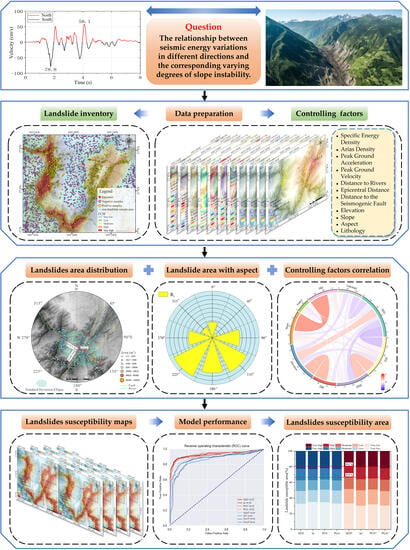
:
1. Introduction
2. Study Area and Materials
2.1. Study Area
2.2. Landslide Inventory
2.3. Spatial Distribution Pattern
2.3.1. Landslide Number Density
2.3.2. Landslide Area Percentage
2.3.3. Standard Deviational Ellipse
2.3.4. Slope Aspect
3. Methodology
3.1. Selection and Analysis of Landslide Controlling Factors
3.1.1. Selection of Landslide Controlling Factors
3.1.2. Correlation Analysis of Landslides and Controlling Factors
3.1.3. Correlation Analysis of Controlling Factors
3.2. Model Strategy
4. Results
4.1. Landslide Susceptibility Mapping
4.2. Evaluation of the Models
4.2.1. Model Performance
4.2.2. Comparison of Predicted Areas
4.3. The Importance of Controlling Factors
5. Discussion
5.1. The Completeness of the Landslide Inventory
5.2. Strategies for Selecting Landslide Samples and Prediction Models
5.3. Influence of Landslide Size
6. Conclusions
- (1)
- The Ludian earthquake-triggered landslides are not linearly concentrated along the seismogenic fault, but rather dispersed along major river systems with an NE–SW trend. The two most important factors that significantly affected the spatial distribution of these landslides were found to be the distance to rivers and elevation.
- (2)
- The values for slopes facing SE, S, and SW are 1.3, 1.23, and 1.41, respectively, while slopes facing N, NW, and NE have much lower values (0.77, 0.68, and 0.52). Therefore, the percentage of landslide source area on the slopes facing south is much larger than that on the slopes facing north, which is consistent with seismic energy variations, i.e., the value of ground motion parameters in the south is larger than that in the north.
- (3)
- The model’s performance and its ability to accurately represent the spatial distribution of co-seismic landslides were essentially the same, regardless of whether the analysis incorporated PGA, PGV, Ia, or SED. However, in comparison to PGAd, PGVd and Iad, SEDd emerged as the most effective ground motion parameter for interpreting the distribution of co-seismic landslides.
- (4)
- The occurrence of co-seismic landslides during the 2014 Ludian earthquake exhibits a significant relationship between the directional variation in ground motion parameters and different slope aspects. Although the AUC of the model slightly decreases when the directional variation in ground motion parameters is taken into account, there is a notable reduction in the proportion of areas of “high” and “very high” landslide susceptibility. This adjustment results in a better accordance between the model’s prediction and the actual distribution of landslides. Therefore, we suggest that the directional variation in ground motion parameters plays an essential role and should be taken into account in the co-seismic landslide susceptibility mapping for the Ludian earthquake.
Author Contributions
Funding
Data Availability Statement
Acknowledgments
Conflicts of Interest
References
- Keefer, D.K. Landslides caused by earthquakes. Geol. Soc. Am. Bull. 1984, 95, 406–421. [Google Scholar] [CrossRef]
- Xu, X.W.; Jiang, G.Y.; Yu, G.H.; Wu, X.Y.; Li, X. Discussion on seismogenic fault of the Ludian M (s) 6.5 earthquake and its tectonic attribution. Chin. J. Geophys. 2014, 57, 3060–3068. [Google Scholar]
- Huang, R.Q.; Li, W.L. Analysis of the geo-hazards triggered by the 12 May 2008 Wenchuan Earthquake, China. Bull. Eng. Geol. Environ. 2009, 68, 363–371. [Google Scholar] [CrossRef]
- Cui, P.; Lin, Y.M.; Chen, C. Destruction of vegetation due to geo-hazards and its environmental impacts in the Wenchuan earthquake areas. Ecol. Eng. 2012, 44, 61–69. [Google Scholar] [CrossRef]
- Yin, Y.P.; Wang, F.R.; Sun, P. Landslide hazards triggered by the 2008 Wenchuan earthquake, Sichuan, China. Landslides 2009, 6, 139–152. [Google Scholar] [CrossRef]
- Bommer, J.J.; Rodrίguez, C.E. Earthquake-induced landslides in Central America. Eng. Geol. 2002, 63, 189–220. [Google Scholar] [CrossRef]
- Xu, Q.; Fan, X.M.; Huang, R.Q.; Yin, Y.P.; Hou, S.S.; Dong, X.J.; Tang, M.G. A catastrophic rockslide-debris flow in Wulong, Chongqing, China in 2009: Background, characterization, and causes. Landslides 2010, 7, 75–87. [Google Scholar] [CrossRef]
- Huang, R.Q.; Li, W.L. Formation, distribution and risk control of landslides in China. J. Rock Mech. Geotech. Eng. 2011, 3, 97–116. [Google Scholar] [CrossRef]
- Fan, X.M.; van Westen, C.J.; Korup, O.; Gorum, T.; Xu, Q.; Dai, F.C.; Huang, R.Q.; Wang, G.H. Transient water and sediment storage of the decaying landslide dams induced by the 2008 Wenchuan earthquake, China. Geomorphology 2012, 171, 58–68. [Google Scholar] [CrossRef]
- Du, W.Q.; Wang, G. A one-step Newmark displacement model for probabilistic seismic slope displacement hazard analysis. Eng. Geol. 2016, 205, 12–23. [Google Scholar] [CrossRef]
- Zhao, L.H.; Zuo, S.; Deng, D.P.; Han, Z.; Zhao, B. Development mechanism for the landslide at Xinlu village, Chongqing, China. Landslides 2018, 15, 2075–2081. [Google Scholar] [CrossRef]
- Dunning, S.; Mitchell, W.; Rosser, N.; Petley, D. The Hattian Bala rock avalanche and associated landslides triggered by the Kashmir Earthquake of 8 October 2005. Eng. Geol. 2007, 93, 130–144. [Google Scholar] [CrossRef]
- Wang, H.B.; Sassa, K.; Xu, W.Y. Analysis of a spatial distribution of landslides triggered by the 2004 Chuetsu earthquakes of Niigata Prefecture, Japan. Nat. Hazards 2007, 41, 43–60. [Google Scholar] [CrossRef]
- Sato, H.P.; Hasegawa, H.; Fujiwara, S.; Tobita, M.; Koarai, M.; Une, H.; Iwahashi, J. Interpretation of landslide distribution triggered by the 2005 Northern Pakistan earthquake using SPOT 5 imagery. Landslides 2007, 4, 113–122. [Google Scholar] [CrossRef]
- Fan, X.M.; Juang, C.H.; Wasowski, J.; Huang, R.Q.; Xu, Q.; Scaringi, G.; van Westen, C.J.; Havenith, H.B. What we have learned from the 2008 Wenchuan Earthquake and its aftermath: A decade of research and challenges. Eng. Geol. 2018, 241, 25–32. [Google Scholar] [CrossRef]
- Liu, Y.; Zhang, W.; Zhang, Z. Risk factor detection and landslide susceptibility mapping using Geo-Detector and Random Forest Models: The 2018 Hokkaido eastern Iburi earthquake. Remote Sens. 2021, 13, 1157. [Google Scholar] [CrossRef]
- Sboras, S.; Lazos, I.; Bitharis, S.; Pikridas, C.; Galanakis, D.; Fotiou, A.; Chatzipetros, A.; Pavlides, S. Source modelling and stress transfer scenarios of the October 30, 2020 Samos earthquake: Seismotectonic implications. Turk. J. Earth Sci. 2021, 30, 699–717. [Google Scholar] [CrossRef]
- Xiong, Y.B.; Zhou, Y.; Wang, F.T.; Wang, S.X. A Novel Intelligent Method Based on the Gaussian Heatmap Sampling Technique and Convolutional Neural Network for Landslide Susceptibility Mapping. Remote Sens. 2022, 14, 2866. [Google Scholar] [CrossRef]
- Keefer, D.K. Investigating landslides caused by earthquakes—A historical review. Surv. Geophys. 2002, 23, 473–510. [Google Scholar] [CrossRef]
- Rodrıguez, C.; Bommer, J.; Chandler, R. Earthquake-induced landslides: 1980–1997. Soil Dyn. Earthq. Eng. 1999, 18, 325–346. [Google Scholar] [CrossRef]
- Keefer, D.K. Statistical analysis of an earthquake-induced landslide distribution—The 1989 Loma Prieta, California event. Eng. Geol. 2000, 58, 231–249. [Google Scholar] [CrossRef]
- Mahdavifar, M.R.; Solaymani, S.; Jafari, M.K. Landslides triggered by the Avaj, Iran earthquake of June 22, 2002. Eng. Geol. 2006, 86, 166–182. [Google Scholar] [CrossRef]
- Papadopoulos, G.A.; Plessa, A. Magnitude-distance relations for earthquake-induced landslides in Greece. Eng. Geol. 2000, 58, 377–386. [Google Scholar] [CrossRef]
- Chuang, R.Y.; Wu, B.S.; Liu, H.C.; Huang, H.H.; Lu, C.H. Development of a statistics-based nowcasting model for earthquake-triggered landslides in Taiwan. Eng. Geol. 2021, 289, 106177. [Google Scholar] [CrossRef]
- Fan, X.M.; Yunus, A.P.; Scaringi, G.; Catani, F.; Siva Subramanian, S.; Xu, Q.; Huang, R.Q. Rapidly evolving controls of landslides after a strong earthquake and implications for hazard assessments. Geophys. Res. Lett. 2021, 48, e2020GL090509. [Google Scholar] [CrossRef]
- Lombardo, L.; Tanyas, H. Chrono-validation of near-real-time landslide susceptibility models via plug-in statistical simulations. Eng. Geol. 2020, 278, 105818. [Google Scholar] [CrossRef]
- Tanyaş, H.; Lombardo, L. Variation in landslide-affected area under the control of ground motion and topography. Eng. Geol. 2019, 260, 105229. [Google Scholar] [CrossRef]
- Foulser-Piggott, R.; Stafford, P.J. A predictive model for arias intensity at multiple sites and consideration of spatial correlations. Earthq. Eng. Struct. Dyn. 2012, 41, 431–451. [Google Scholar] [CrossRef]
- Chang, Z.; Sun, X.; Zhai, C.; Zhao, J.X.; Xie, L. An improved energy-based approach for selecting pulse-like ground motions. Earthq. Eng. Struct. Dyn. 2016, 45, 2405–2411. [Google Scholar] [CrossRef]
- Shahi, S.K.; Baker, J.W. An efficient algorithm to identify strong-velocity pulses in multicomponent ground motions. Bull. Seismol. Soc. Am. 2014, 104, 2456–2466. [Google Scholar] [CrossRef]
- Zhai, C.H.; Chang, Z.W.; Li, S.; Chen, Z.Q.; Xie, L.L. Quantitative identification of near-fault pulse-like ground motions based on energy. Bull. Seismol. Soc. Am. 2013, 103, 2591–2603. [Google Scholar] [CrossRef]
- Del Gaudio, V.; Pierri, P.; Wasowski, J. An approach to time-probabilistic evaluation of seismically induced landslide hazard. Bull. Seismol. Soc. Am. 2003, 93, 557–569. [Google Scholar] [CrossRef]
- Harp, E.L.; Wilson, R.C. Shaking intensity thresholds for rock falls and slides: Evidence from 1987 Whittier Narrows and Superstition Hills earthquake strong-motion records. Bull. Seismol. Soc. Am. 1995, 85, 1739–1757. [Google Scholar]
- Jibson, R.W. Regression models for estimating coseismic landslide displacement. Eng. Geol. 2007, 91, 209–218. [Google Scholar] [CrossRef]
- Nguyen, D.D.; Thusa, B.; Azad, M.S.; Tran, V.L.; Lee, T.H. Optimal earthquake intensity measures for probabilistic seismic demand models of ARP1400 reactor containment building. Nucl. Eng. Technol. 2021, 53, 4179–4188. [Google Scholar] [CrossRef]
- Oliaei, M.; Basirat, R. The effect of earthquake frequency content on the internal forces in the tunnels permanent lining. J. Earthq. Eng. 2022, 26, 817–836. [Google Scholar] [CrossRef]
- Wen, K.; Shimada, H.; Sasaoka, T.; Zhang, Z.Y. Numerical study of plastic response of urban underground rock tunnel subjected to earthquake. Int. J. Geo-Eng. 2017, 8, 28. [Google Scholar] [CrossRef]
- Wong, K.K. Inelastic seismic response analysis based on energy density spectra. J. Earth Eng. 2004, 8, 315–334. [Google Scholar] [CrossRef]
- Sandeep, G.; Prasad, S. Housner intensity and specific energy density for earthquake damage assessment from seismogram. In Proceedings of the International Conference on Advances in Architecture and Civil Engineering (AARCV 2012), Karnataka, India, 21–23 June 2012; Volume 1, pp. 335–338. [Google Scholar]
- Ghamari, M.; Shooshtari, M. Understanding the contribution of different earthquake parameters to its destructive power. In Proceedings of the First International Conference on Earthquake and Seismic Geotechnical Engineering, Tabriz, Iran, 25–26 May 2021. [Google Scholar]
- David, P. Earthquake Induced Landslides Lessons from Taiwan and Pakistan; Chengdu University of Technology: Chengdu, China, 2008. [Google Scholar]
- Xu, Q.; Zhang, S.; Li, W.L. Spatial distribution of large-scale landslides induced by the 5.12 Wenchuan earthquake. J. Mt. Sci. 2011, 8, 246–260. [Google Scholar] [CrossRef]
- Chang, M.; Zhou, Y.; Zhou, C.; Hales, T.C. Coseismic landslides induced by the 2018 Mw 6.6 Iburi, Japan, Earthquake: Spatial distribution, key factors weight, and susceptibility regionalization. Landslides 2021, 18, 755–772. [Google Scholar] [CrossRef]
- Kuo, C.Y.; Chang, K.J.; Tsai, P.W.; Wei, S.K.; Chen, R.F.; Dong, J.J.; Yang, C.M.; Chan, Y.C.; Tai, Y.C. Identification of co-seismic ground motion due to fracturing and impact of the Tsaoling landslide, Taiwan. Eng. Geol. 2015, 196, 268–279. [Google Scholar] [CrossRef]
- Tatard, L.; Grasso, J. Controls of earthquake faulting style on near field landslide triggering: The role of coseismic slip. J. Geophys. Res. Solid Earth 2013, 118, 2953–2964. [Google Scholar] [CrossRef]
- Chen, G.Q.; Xia, M.Y.; Thuy, D.T.; Zhang, Y.B. A possible mechanism of earthquake-induced landslides focusing on pulse-like ground motions. Landslides 2021, 18, 1641–1657. [Google Scholar] [CrossRef]
- Champion, C.; Liel, A. The effect of near-fault directivity on building seismic collapse risk. Earthq. Eng. Struct. Dyn. 2012, 41, 1391–1409. [Google Scholar] [CrossRef]
- Gazi, H.; Alhan, C. Reliability of elastomeric-isolated buildings under historical earthquakes with/without forward-directivity effects. Eng. Struct. 2019, 195, 490–507. [Google Scholar] [CrossRef]
- Gentile, R.; Galasso, C. Accounting for directivity-induced pulse-like ground motions in building portfolio loss assessment. Bull. Earthq. Eng. 2021, 19, 6303–6328. [Google Scholar] [CrossRef]
- Veggalam, S.; Reddy, K.; Somala, S.N. Collapse fragility due to near-field directivity ground motions: Influence of component, rupture distance, hypocenter location. Structures 2021, 34, 3684–3702. [Google Scholar] [CrossRef]
- Cheng, J.; Xu, X.W.; Liu, J. Cause and rupture characteristics of the 2014 Ludian Ms 6.5 mainshock and its aftershock distribution using the coulomb stress changes. Chin. J. Geophys. 2016, 59, 556–567. (In Chinese) [Google Scholar]
- Luo, J.; Pei, X.J.; Evans, S.G.; Huang, R.Q. Mechanics of the earthquake-induced Hongshiyan landslide in the 2014 Mw 6.2 Ludian earthquake, Yunnan, China. Eng. Geol. 2019, 251, 197–213. [Google Scholar] [CrossRef]
- Luo, J.; Evans, S.G.; Pei, X.J.; Huang, R.Q.; Liu, M.; Dong, X.J. Anomalous co-seismic surface effects produced by the 2014 Mw 6.2 Ludian earthquake, Yunnan, China: An example of complex faulting related to Riedel shear structures. Eng. Geol. 2020, 266, 105476. [Google Scholar] [CrossRef]
- Riaz, M.S.; Zheng, Y.; Xiong, X.; Xie, Z.J.; Li, Z.; Song, M.Q. Refined 3d seismic-velocity structures and seismogenic environment of the Ms 6.5 Ludian earthquake. Bull. Seismol. Soc. Am. 2017, 107, 3023–3036. [Google Scholar] [CrossRef]
- Xu, X.W.; Xu, C.; Yu, G.H.; Wu, X.Y.; Li, X.; Zhang, J.G. Primary surface ruptures of the Ludian Mw 6.2 earthquake, southeastern Tibetan Plateau, China. Seismol. Res. Lett. 2015, 86, 1622–1635. [Google Scholar] [CrossRef]
- Luo, J. Slope Dynamic Response and Formation Mechanism of Large-Scale Rockslide Dam in the “8.3” Ludian Earthquake; Chengdu University of Technology: Chengdu, China, 2020. (In Chinese) [Google Scholar]
- Zou, Y.; Qi, S.W.; Guo, S.F.; Zheng, B.W.; Zhan, Z.F.; He, N.W.; Huang, X.L.; Hou, X.K.; Liu, H.Y. Factors controlling the spatial distribution of coseismic landslides triggered by the Mw 6.1 Ludian earthquake in China. Eng. Geol. 2022, 296, 106477. [Google Scholar] [CrossRef]
- Chen, X.L.; Liu, C.G.; Wang, M.M.; Zhou, Q. Causes of unusual distribution of coseismic landslides triggered by the Mw 6.1 2014 Ludian, Yunnan, China earthquake. J. Asian Earth Sci. 2018, 159, 17–23. [Google Scholar] [CrossRef]
- Reichenbach, P.; Rossi, M.; Malamud, B.D.; Mihir, M.; Guzzetti, F. A review of statistically-based landslide susceptibility models. Earth-Sci. Rev. 2018, 180, 60–91. [Google Scholar] [CrossRef]
- Lee, J.H.; Sameen, M.I.; Pradhan, B.; Park, H.J. Modeling landslide susceptibility in data-scarce environments using optimized data mining and statistical methods. Geomorphology 2018, 303, 284–298. [Google Scholar] [CrossRef]
- Huang, Y.; Zhao, L. Review on landslide susceptibility mapping using support vector machines. Catena 2018, 165, 520–529. [Google Scholar] [CrossRef]
- Marjanović, M.; Kovačević, M.; Bajat, B.; Voženílek, V. Landslide susceptibility assessment using SVM machine learning algorithm. Eng. Geol. 2011, 123, 225–234. [Google Scholar] [CrossRef]
- Ayalew, L.; Yamagishi, H. The application of GIS-based logistic regression for landslide susceptibility mapping in the Kakuda-Yahiko Mountains, Central Japan. Geomorphology 2005, 65, 15–31. [Google Scholar] [CrossRef]
- Lombardo, L.; Mai, P.M. Presenting logistic regression-based landslide susceptibility results. Eng. Geol. 2018, 244, 14–24. [Google Scholar] [CrossRef]
- Catani, F.; Lagomarsino, D.; Segoni, S.; Tofani, V. Landslide susceptibility estimation by random forests technique: Sensitivity and scaling issues. Nat. Hazards Earth Syst. Sci. 2013, 13, 2815–2831. [Google Scholar] [CrossRef]
- Youssef, A.M.; Pourghasemi, H.R.; Pourtaghi, Z.S.; Al-Katheeri, M.M. Landslide susceptibility mapping using random forest, boosted regression tree, classification and regression tree, and general linear models and comparison of their performance at Wadi Tayyah Basin, Asir Region, Saudi Arabia. Landslides 2016, 13, 839–856. [Google Scholar] [CrossRef]
- Shao, X.; Xu, C. Earthquake-induced landslides susceptibility assessment: A review of the state-of-the-art. Nat. Hazards Res. 2022, 2, 172–182. [Google Scholar] [CrossRef]
- Guo, X.H.; Wei, D.P.; Zhang, K.L. GPS-constrained estimate method of present-day slip rate along major faults of Sichuan-Yunnan region in China. J. Univ. Chin. Acad. Sci. 2013, 30, 74–82. (In Chinese) [Google Scholar]
- Song, F.M. Preliminary results of the investigation of paleo-earthquakes along the Daliangshan fault zone, Sichuan Province, China. Seismol. Geol. 2002, 24, 27–34. [Google Scholar]
- Zhang, P.Z.; Deng, Q.D.; Zhang, G.M.; Ma, J.; Gan, W.J.; Min, W.; Mao, F.Y.; Wang, Q. Active tectonic blocks and strong earthquakes in the continent of China. Sci. China Ser. D Earth Sci. 2003, 46, 13–24. [Google Scholar]
- Wu, W.Y.; Xu, C.; Wang, X.Q.; Tian, Y.Y.; Deng, F. Landslides Triggered by the 3 August 2014 Ludian (China) Mw 6.2 Earthquake: An Updated Inventory and Analysis of Their Spatial Distribution. J. Earth Sci. 2020, 31, 853–866. [Google Scholar] [CrossRef]
- Lee, C.T.; Huang, C.C.; Lee, J.F. Statistical approach to earthquake-induced landslide susceptibility. Eng. Geol. 2008, 100, 43–58. [Google Scholar] [CrossRef]
- Parise, M.; Jibson, R.W. A seismic landslide susceptibility rating of geologic units based on analysis of characteristics of landslides triggered by the 17 January, 1994 Northridge, California earthquake. Eng. Geol. 2000, 58, 251–270. [Google Scholar] [CrossRef]
- Pourghasemi, H.R.; Rahmati, O. Prediction of the landslide susceptibility: Which algorithm, which precision? Catena 2018, 162, 177–192. [Google Scholar] [CrossRef]
- Bordoni, M.; Galanti, Y.; Bartelletti, C. The influence of the inventory on the determination of the rainfall-induced shallow landslides susceptibility using generalized additive models. Catena 2020, 193, 104630. [Google Scholar] [CrossRef]
- Nefeslioglu, H.A.; Gokceoglu, C.; Sonmez, H. An assessment on the use of logistic regression and artificial neural networks with different sampling strategies for the preparation of landslide susceptibility maps. Eng. Geol. 2008, 97, 171–191. [Google Scholar] [CrossRef]
- Zhu, A.X.; Miao, Y.; Liu, J. A similarity-based approach to sampling absence data for landslide susceptibility mapping using data-driven methods. Catena 2019, 183, 104188. [Google Scholar] [CrossRef]
- Zhou, C.; Gan, L.L.; Wang, Y. Regional landslide susceptibility modeling with integrated non-landslide sample selection index and heterogeneous integrated machine learning. J. Geo-Info. Sci. 2023, 25, 1570–1585. (In Chinese) [Google Scholar]
- Huang, F.M.; Zeng, S.Y.; Huang, J.S. Uncertainty in predictive modeling of landslide susceptibility: The effect of different “non-landslide sample” selection methods. Eng. Sci. Technol. 2023, 1, 1–14. (In Chinese) [Google Scholar]
- Liang, Z. Comprehensive Application and Study of Machine Learning in Susceptibility Evaluation of Shallow landslides; Jilin University: Changchun, China, 2022. (In Chinese) [Google Scholar]
- Chen, X.L.; Zhou, Q.; Liu, C.G. Distribution pattern of coseismic landslides triggered by the 2014 Ludian, Yunnan, China Mw 6.1 earthquake: Special controlling conditions of local topography. Landslides 2016, 13, 1597. [Google Scholar]
- Jenks, G.F. The data model concept in statistical mapping. Int. Yearb. Cartogr. 1967, 7, 186–190. [Google Scholar]
- Chigira, M.; Wu, X.Y.; Inokuchi, T.; Wang, G.H. Landslides induced by the 2008 Wenchuan earthquake, Sichuan, China. Geomorphology 2010, 118, 225–238. [Google Scholar] [CrossRef]
- Louangrath, P. Correlation coefficient according to data classification. SSRN 2014, 2417910. [Google Scholar] [CrossRef]
- Reynolds, H.T. Analysis of Nominal Data; Sage: London, UK, 1984. [Google Scholar]
- Breiman, L. Random forests. Mach. Learn. 2001, 45, 5–32. [Google Scholar] [CrossRef]
- de Oliveira, G.G.; Ruiz, L.F.C.; Guasselli, L.A.; Haetinger, C. Random forest and artificial neural networks in landslide susceptibility modeling: A case study of the Fão River Basin, Southern Brazil. Nat. Hazard 2019, 99, 1049–1073. [Google Scholar] [CrossRef]
- Mandrekar, J.N. Receiver operating characteristic curve in diagnostic test assessment. J. Thorac. Oncol. 2010, 5, 1315–1316. [Google Scholar] [CrossRef]
- Fadhillah, M.F.; Achmad, A.R.; Lee, C.W. Integration of InSAR time-series data and GIS to assess land subsidence along subway lines in the Seoul metropolitan area, South Korea. Remote Sens. 2020, 12, 3505. [Google Scholar] [CrossRef]
- Jaafari, A.; Panahi, M.; Pham, B.T.; Shahabi, H.; Bui, D.T.; Rezaie, F.; Lee, S. Meta optimization of an adaptive neuro-fuzzy inference system with grey wolf optimizer and biogeography-based optimization algorithms for spatial prediction of landslide susceptibility. Catena 2019, 175, 430–445. [Google Scholar] [CrossRef]
- Bui, D.T.; Shahabi, H.; Omidvar, E.; Shirzadi, A.; Geertsema, M.; Clague, J.J.; Khosravi, K.; Pradhan, B.; Pham, B.T.; Chapi, K.; et al. Shallow landslide prediction using a novel hybrid functional machine learning algorithm. Remote Sens. 2019, 11, 22. [Google Scholar]
- Dou, J.; Yunus, A.P.; Merghadi, A.; Shirzadi, A.; Nguyen, H.; Hussain, Y.; Avtar, R.; Chen, Y.; Pham, B.T.; Yamagishi, H. Different sampling strategies for predicting landslide susceptibilities are deemed less consequential with deep learning. Sci. Total Environ. 2020, 720, 16. [Google Scholar] [CrossRef] [PubMed]
- Yi, Y.N.; Zhang, Z.J.; Zhang, W.C.; Jia, H.H.; Zhang, J.Q. Landslide susceptibility mapping using multiscale sampling strategy and convolutional neural network: A case study in Jiuzhaigou region. Catena 2020, 195, 104851. [Google Scholar] [CrossRef]
- Hakan, T.; Luigi, L. Completeness index for earthquake-induced landslide inventories. Eng. Geol. 2020, 264, 105331. [Google Scholar] [CrossRef]
- Lombardo, L.; Tanyas, H.; Huser, R.; Guzzetti, F.; Castro-Camilo, D. Landslide size matters: A new data-driven, spatial prototype. Eng. Geol. 2021, 293, 28. [Google Scholar] [CrossRef]
- Aguilera, Q.; Lombardo, L.; Tanyas, H.; Lipani, A. On the prediction of landslide occurrences and sizes via Hierarchical Neural Networks. Stoch. Environ. Res. Risk Assess. 2022, 36, 2031–2048. [Google Scholar] [CrossRef]


| No. | Data Type | Date | Resolution (m) |
|---|---|---|---|
| 1 | Sentinel-2A | 1 August 2014 | 10 |
| 2 | GF-1 | 26 October 2014 | 2 |
| 3 | GF-2 | 14 February 2015 | 1 |
| 4 | Google Earth data | 30 January 2014, 20 August 2014 | 0.5 |
| 5 | UAV | 15 September 2015 | 0.2 |
| CenterX | CenterY | XStdDist (m) | YstdDist (m) | Angle | Area (km2) | |
|---|---|---|---|---|---|---|
| SDE (LND) | 103.349 | 27.082 | 8210.6 | 5861.1 | 118.3 | 150.4 |
| SDE (LAP) | 103.358 | 27.074 | 8757.5 | 5144.5 | 122.1 | 140.8 |
| Aspect | Ai (km2) | DAi (km2) | Ai/A | DAi/DA | Ri |
|---|---|---|---|---|---|
| N | 40.557813 | 0.368961 | 0.111869 | 0.086252 | 0.771013 |
| NE | 38.280625 | 0.237103 | 0.105588 | 0.055428 | 0.524946 |
| E | 41.409688 | 0.509088 | 0.114218 | 0.119010 | 1.041950 |
| SE | 53.787188 | 0.825668 | 0.148359 | 0.193017 | 1.301016 |
| S | 43.641719 | 0.631193 | 0.120375 | 0.147555 | 1.225792 |
| SW | 43.391094 | 0.721878 | 0.119684 | 0.168754 | 1.410000 |
| W | 50.311563 | 0.570736 | 0.138772 | 0.133421 | 0.961443 |
| NW | 51.168438 | 0.413066 | 0.141136 | 0.096563 | 0.684184 |
| No. | Stratum | Lithology Description |
|---|---|---|
| 1 | D1 | Lower Devonian System. Clastic rocks |
| 2 | D2 | Middle Devonian System. Quartz sandstone, siltstone, dolomite |
| 3 | O1 | Lower Ordovician System. Fine sandstone, dolomite, mica siltstone |
| 4 | O2 | Middle Ordovician System. Dolomite, sandstone with shale and argillaceous limestone |
| 5 | O3 | Upper Ordovician System. Dolomite, sandstone with shale and argillaceous limestone |
| 6 | P1 | Lower Permian System. Siltstone, shale, limestone |
| 7 | P2 | Upper Permian System. Mudstone, porphyritic basalt, volcanic breccia |
| 8 | S2 | Middle Silurian System. Shale, carbonatite, clastic rocks |
| 9 | T1 | Lower Triassic System. Siltstone, argillaceous siltstone with fine sandstone |
| 10 | Z1 | Lower Sinian System. Basal conglomerate, pebbly sandstone, sandstone, quartz sandstone |
| 11 | Z2 | Upper Sinian System. Dolomite, dolomite limestone, dolomitic shale |
| 12 | Є1 | Lower Cambrian System. Sandstone, shale, dolomite, argillaceous limestone |
| 13 | Є2 | Middle Cambrian System. Gray dolomite, shale with siltstone, clastic rock, argillaceous limestone |
| 14 | Є3 | Upper Cambrian System. Gray dolomite, shale with siltstone, clastic rock, argillaceous limestone |
| Factor | Variable | Data Source | Resampled Resolution |
|---|---|---|---|
| Seismic factor | PGA | China Earthquake Administration | 12.5 m |
| PGV | ″ | ||
| SED | ″ | ||
| Ia | ″ | ||
| PGAd | ″ | ||
| PGVd | ″ | ||
| SEDd | ″ | ||
| Iad | ″ | ||
| ED | ″ | ||
| DSF | ″ | ||
| Topographic factor | Elevation | ALOS DEM | ″ |
| Aspect | ″ | ||
| Slope | ″ | ||
| TRI | ″ | ||
| TWI | ″ | ||
| DR | ″ | ||
| Geological factor | Lithology | China Geological Survey | ″ |
| Model | Model Formula |
|---|---|
| 1 | PGA + Elevation + Slope + Aspect + ED + DSF + DR + Lithology |
| 2 | PGV + Elevation + Slope + Aspect + ED + DSF + DR + Lithology |
| 3 | SED + Elevation + Slope + Aspect + ED + DSF + DR + Lithology |
| 4 | Ia + Elevation + Slope + Aspect + ED + DSF + DR + Lithology |
| 5 | PGAd + Elevation + Slope + Aspect + ED + DSF + DR + Lithology |
| 6 | PGVd + Elevation + Slope + Aspect + ED + DSF + DR + Lithology |
| 7 | SEDd + Elevation + Slope + Aspect + ED + DSF + DR + Lithology |
| 8 | Iad + Elevation + Slope + Aspect + ED + DSF + DR + Lithology |
| Scheme | Very Low | Low | Moderate | High | Very High | High + Very High |
|---|---|---|---|---|---|---|
| SED | 32.9 | 16.38 | 13.59 | 14.74 | 22.4 | 37.14 |
| Ia | 35.17 | 15.1 | 12.79 | 14.18 | 22.75 | 36.93 |
| PGV | 34.86 | 16.08 | 12.99 | 14.32 | 21.75 | 36.07 |
| PGA | 33.27 | 16.62 | 12.78 | 14.51 | 22.82 | 37.33 |
| SEDd | 33.33 | 18.39 | 14.85 | 14.23 | 19.2 | 33.43 |
| Iad | 30.28 | 19.84 | 14.11 | 15.38 | 20.4 | 35.78 |
| PGVd | 32.1 | 19.01 | 14.13 | 15.04 | 19.72 | 34.76 |
| PGAd | 30.57 | 18.46 | 14.62 | 14.66 | 21.69 | 36.35 |
Disclaimer/Publisher’s Note: The statements, opinions and data contained in all publications are solely those of the individual author(s) and contributor(s) and not of MDPI and/or the editor(s). MDPI and/or the editor(s) disclaim responsibility for any injury to people or property resulting from any ideas, methods, instructions or products referred to in the content. |
© 2023 by the authors. Licensee MDPI, Basel, Switzerland. This article is an open access article distributed under the terms and conditions of the Creative Commons Attribution (CC BY) license (https://creativecommons.org/licenses/by/4.0/).
Share and Cite
Duan, Y.; Luo, J.; Pei, X.; Liu, Z. Co-Seismic Landslides Triggered by the 2014 Mw 6.2 Ludian Earthquake, Yunnan, China: Spatial Distribution, Directional Effect, and Controlling Factors. Remote Sens. 2023, 15, 4444. https://doi.org/10.3390/rs15184444
Duan Y, Luo J, Pei X, Liu Z. Co-Seismic Landslides Triggered by the 2014 Mw 6.2 Ludian Earthquake, Yunnan, China: Spatial Distribution, Directional Effect, and Controlling Factors. Remote Sensing. 2023; 15(18):4444. https://doi.org/10.3390/rs15184444
Chicago/Turabian StyleDuan, Yuying, Jing Luo, Xiangjun Pei, and Zhuo Liu. 2023. "Co-Seismic Landslides Triggered by the 2014 Mw 6.2 Ludian Earthquake, Yunnan, China: Spatial Distribution, Directional Effect, and Controlling Factors" Remote Sensing 15, no. 18: 4444. https://doi.org/10.3390/rs15184444