

Can Sea Surface Waves Be Simulated by Numerical Wave Models Using the Fusion Data from Remote-Sensed Winds?

Abstract
:1. Introduction
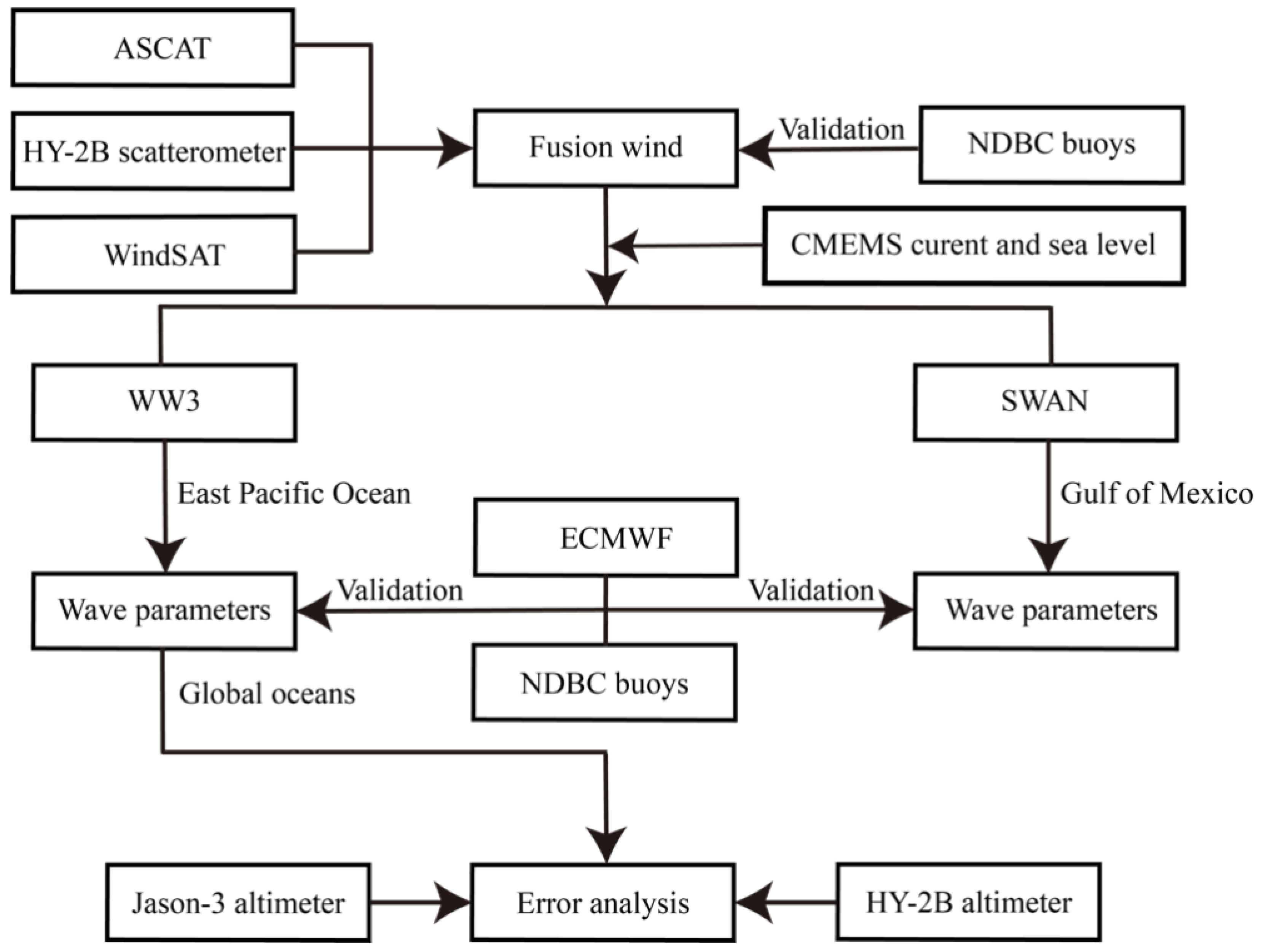
2. Datasets
2.1. Remoted-Sensed Winds
2.2. Waves from Altimeters and ECMWF
2.3. NDBC Buoys
3. Methodology
3.1. Method for Data Fusion and Evaluation Metrics
3.2. Model Settings of the Numerical Wave Models
4. Results
4.1. Validation of Fusion Wind
4.2. Validation of Hindcasting Wave
4.3. Evaluation with the Altimeter Products
5. Conclusions
Author Contributions
Funding
Data Availability Statement
Acknowledgments
Conflicts of Interest
References
- Liu, Q.X.; Alexander, V.B.; Stefan, Z.; Young, L.R.; Guan, C.L. Wind and wave climate in the Arctic Ocean as observed by Altimeters. J. Clim. 2016, 29, 7957–7975. [Google Scholar] [CrossRef]
- Isaksen, L.; Stoffelen, A. ERS Scatterometer Wind data impact on ECMWF’s tropical cyclone forecasts. IEEE Trans. Geosci. Remote Sens. 2000, 38, 1885–1892. [Google Scholar] [CrossRef]
- Satheesan, K.; Sarkar, A.; Parekh, A.; Kumar, M.; Kuroda, Y. Comparison of wind data from QuikSCAT and buoys in the Indian Ocean. Int. J. Remote Sens. 2007, 28, 2375–2382. [Google Scholar] [CrossRef]
- Stoffelen, A.; Verspeek, J.A.; Vogelzang, J.; Verhoef, A. The CMOD7 Geophysical model function for ASCAT and ERS wind retrievals. IEEE J. Sel. Top. Appl. Earth Observ. Remote Sens. 2017, 10, 2123–2134. [Google Scholar] [CrossRef]
- Shao, W.Z.; Jiang, T.; Jiang, X.W.; Zhang, Y.G.; Zhou, W. Evaluation of sea surface winds and waves retrieved from the Chinese HY-2B data. IEEE J. Sel. Top. Appl. Earth Observ. Remote Sens. 2021, 14, 9624–9635. [Google Scholar] [CrossRef]
- Shao, W.; Jiang, T.; Zhang, Y.; Shi, J.; Wang, W. Cyclonic wave simulations based on WAVEWATCH-III using a sea surface drag coefficient derived from CFOSAT SWIM data. Atmosphere 2021, 12, 1610. [Google Scholar] [CrossRef]
- Boutin, J.; Etcheto, J. Seasat scatterometer versus scanning multichannel microwave radiometer wind speeds: A comparison on a global scale. J. Geophys. Res. 1990, 95, 22275–22288. [Google Scholar] [CrossRef]
- Hwang, P.; Fois, F. Surface roughness and breaking wave properties retrieved from polarimetric microwave radar backscattering. J. Geophys. Res. 2015, 120, 3640–3657. [Google Scholar] [CrossRef]
- Shao, W.Z.; Li, X.F.; Hwang, P.; Zhang, B.; Yang, X.F. Bridging the gap between cyclone wind and wave by C-band SAR measurements. J. Geophys. Res. 2017, 122, 6714–6724. [Google Scholar] [CrossRef]
- Stoffelen, A.; Anderson, D. Scatterometer data interpretation: Estimation and validation of the transfer function CMOD4. J. Geophys. Res. 1997, 102, 5767–5780. [Google Scholar] [CrossRef]
- Yang, X.F.; Li, X.F.; Zheng, Q.A.; Gu, X.; Pichel, W.; Li, Z.W. Comparison of ocean-surface winds retrieved from QuikSCAT scatterometer and Radarsat-1 SAR in offshore waters of the U.S. west coast. IEEE Geosci. Remote Sens. Lett. 2011, 8, 163–167. [Google Scholar] [CrossRef]
- Lindsley, R.D.; Blodgett, J.R.; Long, D.G. Analysis and validation of high-resolution wind from ASCAT. IEEE Trans. Geosci. Remote Sens. 2016, 54, 5699–5711. [Google Scholar] [CrossRef]
- Freilich, M.H.; Vanhoff, B.A. The accuracy of preliminary WindSat vector wind measurements: Comparisons with NDBC buoys and QuikSCAT. IEEE Trans. Geosci. Remote Sens. 2006, 44, 622–637. [Google Scholar] [CrossRef]
- Meissner, T.; Wentz, F.J. The emissivity of the ocean surface between 6 and 90 GHz over a large range of wind speeds and earth incidence Angles. IEEE Trans. Geosci. Remote Sens. 2012, 50, 3004–3026. [Google Scholar] [CrossRef]
- Tournadre, J.; Morland, J.C. The effects of rain on Topex/Poseidon altimeter data. IEEE Trans. Geosci. Remote Sens. 1997, 35, 1117–1135. [Google Scholar] [CrossRef]
- Abdalla, S. Are Jason-2 significant wave height measurements still useful. Adv. Space Res. 2019, 68, 802–807. [Google Scholar] [CrossRef]
- Wang, J.; Xu, H.; Yang, L.; Song, Q.; Ma, C. Cross-calibrations of the HY-2B altimeter using Jason-3 satellite during the period of April 2019–September 2020. Front. Earth Sci. 2021, 9, 647583. [Google Scholar] [CrossRef]
- Zhai, W.; Zhu, J.; Fan, X.; Yan, L.; Chen, C.; Tian, Z. Preliminary calibration results for Jason-3 and Sentinel-3 altimeters in the Wanshan Islands. J. Ocean. Limnol. 2021, 39, 458–471. [Google Scholar] [CrossRef]
- Shao, W.; Jiang, X.; Sun, Z.; Hu, Y.; Marino, A.; Zhang, Y. Evaluation of wave retrieval for Chinese Gaofen-3 synthetic aperture radar. Geo-Spat. Inf. Sci. 2022, 25, 229–243. [Google Scholar] [CrossRef]
- Wan, Y.; Zhang, X.; Fan, C.; Qu, R.; Ma, E. A joint method for wave and wind field parameter inversion combining SAR with wave spectrometer data. Remote Sens. 2022, 14, 3601. [Google Scholar] [CrossRef]
- Zhao, X.B.; Shao, W.Z.; Zhao, L.B.; Gao, Y.; Yuan, X.Z. Impact of rain on wave retrieval from Sentinel-1 synthetic aperture radar images in tropical cyclones. Adv. Space Res. 2021, 67, 3072–3086. [Google Scholar] [CrossRef]
- Xu, Y.; Liu, J.Q.; Xie, L.L.; Sun, C.R.; Liu, J.P.; Li, J.Y. China-France Oceanography Satellite (CFOSAT) simultaneously observes the typhoon-induced wind and wave fields, Acta Oceanol. Sin. 2019, 38, 158–161. [Google Scholar]
- Tolman, H.L.; Chalikov, D.V. Source terms in a third-generation wind wave model. J. Phys. Oceanogr. 1996, 26, 2497–2518. [Google Scholar] [CrossRef]
- Yang, Z.H.; Shao, W.Z.; Ding, Y.; Shi, J.; Ji, Q.Y. Wave simulation by the SWAN model and FVCOM considering the sea-water level around the Zhoushan islands. J. Mar. Sci. Eng. 2020, 8, 783. [Google Scholar] [CrossRef]
- Hu, Y.Y.; Shao, W.Z.; Li, J.; Zhang, C.L.; Cheng, L.Q.; Ji, Q.Y. Short-term variations in water temperature of the Antarctic Surface layer. J. Mar. Sci. Eng. 2022, 10, 287. [Google Scholar] [CrossRef]
- Chassignet, E.P.; Hulburt, H.E.; Smedstad, O.M.; Halliwell, G.R.; Hogan, P.J. The HYCOM (HYbrid Coordinate Ocean Model) data assimilative system. J. Mar. Syst. 2007, 65, 60–83. [Google Scholar] [CrossRef]
- Balmaseda, M.A.; Vidard, A.; Anderson, D.L.T. The ECMWF ocean analysis system: ORA-S3. Mon. Weather Rev. 2008, 136, 3018–3033. [Google Scholar] [CrossRef]
- Carvalho, D.; Rocha, A.; Gómez-Gesteira, M.; Alvarez, I.; Silva, S.C. Comparison between CCMP, QuikSCAT and buoy winds along the Iberian Peninsula coast. Remote Sens. Environ. 2013, 137, 173–183. [Google Scholar] [CrossRef]
- Shi, J.; Liu, Y.; Li, Y.; Liu, Y.; Roux, G.; Shi, L.; Fan, X. Wind speed forecasts of a mesoscale ensemble for large-scale wind farms in Northern China: Downscaling effect of global model forecasts. Energies 2022, 15, 896. [Google Scholar] [CrossRef]
- Yao, R.; Shao, W.Z.; Hao, M.Y.; Zuo, J.C.; Hu, S. The Respondence of wave on sea surface temperature in the context of global change. Remote Sens. 2023, 15, 1948. [Google Scholar] [CrossRef]
- Rogers, W.E.; Hwang, P.A.; Wang, D.W. Investigation of wave growth and decay in the SWAN model: Three regional-scale applications. J. Phys. Oceanogr. 2010, 33, 366–389. [Google Scholar] [CrossRef]
- Sun, Z.F.; Shao, W.Z.; Wang, W.L.; Yu, W.P.; Shen, W. Analysis of wave-induced Stokes transport effects on sea surface temperature simulations in the Western Pacific Ocean. J. Mar. Sci. Eng. 2021, 9, 834. [Google Scholar] [CrossRef]
- Sheng, Y.X.; Shao, W.Z.; Li, S.Q.; Zhang, Y.M.; Yang, H.W.; Zuo, J.C. Evaluation of typhoon waves simulated by WaveWatch-III model in shallow waters around Zhoushan islands. J. Ocean Univ. China 2019, 18, 365–375. [Google Scholar] [CrossRef]
- Zheng, G.; Li, X.F.; Zhang, R.H.; Liu, B. Purely satellite data-driven deep learning forecast of complicated tropical instability waves. Sci. Adv. 2020, 6, eaba1482. [Google Scholar] [CrossRef] [PubMed]
- Meng, L.S.; Yan, C.; Zhuang, W.; Zhang, W.W.; Yan, X.H. Reconstruction of three-dimensional temperature and salinity fields from satellite observations. J. Geophys. Res-Oceans. 2021, 12, e2021JC017605. [Google Scholar] [CrossRef]
- Hersbach, H.; Stoffelen, A.; Haan, S.D. An improved C-band scatterometer ocean geophysical model function: CMOD5. J. Geophys. Res. 2007, 112, C03006. [Google Scholar] [CrossRef]
- Yao, R.; Shao, W.Z.; Jiang, X.W.; Yu, T. Wind speed retrieval from Chinese Gaofen-3 synthetic aperture radar using an analytical approach in the nearshore waters of China’s Seas. Int. J. Remote Sens. 2022, 43, 3028–3048. [Google Scholar] [CrossRef]
- Meissner, T.; Wentz, F.J. Wind vector retrievals under rain with passive satellite microwave radiometers. IEEE Trans. Geosci. Remote Sens. 2009, 47, 3065–3083. [Google Scholar] [CrossRef]
- Shao, W.Z.; Yuan, X.Z.; Sheng, Y.X.; Sun, J.; Zhou, W.; Zhang, Q.J. Development of wind speed retrieval from cross-polarization Chinese Gaofen-3 synthetic aperture radar in typhoons. Sensors 2018, 18, 412. [Google Scholar] [CrossRef] [Green Version]
- Manaster, A.; Ricciardulli, L.; Meissner, T. Tropical cyclone winds from WindSat, AMSR2, and SMAP: Comparison with the HWRF model. Remote Sens. 2021, 13, 2347. [Google Scholar] [CrossRef]
- Lerch, F.J.; Marsh, J.G.; Klosko, S.M.; Williamson, R.G. Gravity model improvement for SEASAT. J. Geophys. Res. 1982, 87, 3281–3296. [Google Scholar] [CrossRef]
- Xu, G.; Yang, J.; Xu, Y.; Pan, Y.; Chen, X. Validation and calibration of significant wave height from HY-2 satellite altimeter. J. Remote Sens. 2014, 18, 206–214. [Google Scholar]
- Yang, J.; Zhang, J. Validation of Sentinel-3A/3B Satellite Altimetry Wave Heights with Buoy and Jason-3 Data. Sensors 2019, 19, 2914. [Google Scholar] [CrossRef] [Green Version]
- Teng, C.C. Ocean observation from NOAA national data buoy center’s platforms. In Ocean Sensing and Monitoring II; SPIE: Philadelphia, PA, USA, 2010; Volume 7678, pp. 13–17. [Google Scholar]
- Shao, W.Z.; Li, X.F.; Sun, J. Ocean wave parameters retrieval from TerraSAR-X images validated against buoy measurements and model results. Remote Sens. 2015, 7, 12815–12828. [Google Scholar] [CrossRef] [Green Version]
- Liang, G.; Yang, J.; Wang, J. Accuracy evaluation of CFOSAT SWIM L2 products based on NDBC buoy and Jason-3 altimeter data. Remote Sens. 2021, 13, 887. [Google Scholar] [CrossRef]
- Shao, W.Z.; Li, X.M.; Lehner, S.; Guan, C.L. Development of polarization ratio model for sea surface wind field retrieval from TerraSAR-X HH polarization data. Int. J. Remote Sens. 2014, 35, 4046–4063. [Google Scholar] [CrossRef]
- The WAVEWATCH III Development Group (WW3DG). User Manual and System Documentation of WAVEWATCH III, Version 5.16; Techical Note 329; NOAA/NWS/NCEP/MMAB: College Park, MD, USA, 2016; Volume 276, 326p.
- Holthuijsen, L. The Continued Development of the Third-Generation Shallow Water Wave Model ‘SWAN’; Tu Delft Department of Hydraulic Engineering: Delft, The Netherlands, 2001; Volume 32, pp. 185–186. [Google Scholar]
- Shao, W.Z.; Sheng, Y.X.; Li, H.; Shi, J.; Ji, Q.Y.; Tan, W.; Zuo, J.C. Analysis of wave distribution simulated by WAVEWATCH-III model in typhoons passing Beibu Gulf, China. Atmosphere 2018, 9, 265. [Google Scholar] [CrossRef] [Green Version]
- Zheng, K.W.; Osinowo, A.; Sun, J.; Hu, W. Long term characterization of sea conditions in the East China Sea using significant wave height and wind speed. J. Ocean Univ. China 2018, 17, 733–743. [Google Scholar] [CrossRef]
- Shao, W.Z.; Yu, W.P.; Jiang, X.W.; Shi, J.; Wei, Y.L.; Ji, Q.Y. Analysis of wave distributions using the WAVEWATCH-III model in the Arctic Ocean. J. Ocean Univ. China 2022, 21, 15–21. [Google Scholar] [CrossRef]
- Xing, G.; Shen, W.; Wei, M.; Li, H.; Shao, W.Z. Wave and meso-scale eddy climate in the Arctic Ocean. Atmosphere 2023, 14, 911. [Google Scholar] [CrossRef]
- Shao, W.Z.; Jiang, X.W.; Nunziata, F.; Marino, A.; Corcione, V. Analysis of waves observed by synthetic aperture radar across ocean fronts. Ocean Dynam. 2020, 70, 1397–1407. [Google Scholar] [CrossRef]
- Li, X.; Yang, J.; Han, G.; Ren, L.; Zheng, G.; Chen, P.; Zhang, H. Tropical cyclone wind field reconstruction and validation using measurements from SFMR and SMAP radiometer. Remote Sens. 2022, 14, 3929. [Google Scholar] [CrossRef]
- Hu, Y.Y.; Shao, W.Z.; Jiang, X.W.; Zhou, W.; Zuo, J.C. Improvement of VV-polarization tilt MTF for Gaofen-3 SAR data of a tropical cyclone. Remote Sens. Lett. 2023, 14, 461–468. [Google Scholar] [CrossRef]
- Shao, W.Z.; Lai, Z.Z.; Nunziata, F.; Buono, A.; Jiang, X.W.; Zuo, J.C. Wind field retrieval with rain correction from dual-polarized Sentinel-1 SAR imagery collected during tropical cyclones. Remote Sens. 2022, 14, 5006. [Google Scholar] [CrossRef]


Disclaimer/Publisher’s Note: The statements, opinions and data contained in all publications are solely those of the individual author(s) and contributor(s) and not of MDPI and/or the editor(s). MDPI and/or the editor(s) disclaim responsibility for any injury to people or property resulting from any ideas, methods, instructions or products referred to in the content. |
© 2023 by the authors. Licensee MDPI, Basel, Switzerland. This article is an open access article distributed under the terms and conditions of the Creative Commons Attribution (CC BY) license (https://creativecommons.org/licenses/by/4.0/).
Share and Cite
Shi, J.; Shao, W.; Shi, S.; Hu, Y.; Jiang, T.; Zhang, Y. Can Sea Surface Waves Be Simulated by Numerical Wave Models Using the Fusion Data from Remote-Sensed Winds? Remote Sens. 2023, 15, 3825. https://doi.org/10.3390/rs15153825
Shi J, Shao W, Shi S, Hu Y, Jiang T, Zhang Y. Can Sea Surface Waves Be Simulated by Numerical Wave Models Using the Fusion Data from Remote-Sensed Winds? Remote Sensing. 2023; 15(15):3825. https://doi.org/10.3390/rs15153825
Chicago/Turabian StyleShi, Jian, Weizeng Shao, Shaohua Shi, Yuyi Hu, Tao Jiang, and Youguang Zhang. 2023. "Can Sea Surface Waves Be Simulated by Numerical Wave Models Using the Fusion Data from Remote-Sensed Winds?" Remote Sensing 15, no. 15: 3825. https://doi.org/10.3390/rs15153825