

A Machine Learning-Based Multiple Cloud Vertical Structure Parameter Prediction Algorithm Only Using OCO-2 Oxygen A-Band Measurements


Abstract
:
1. Introduction
2. Data
2.1. OCO-2
2.2. CALIPSO and CloudSat
2.3. MODIS
2.4. Auxiliary Data
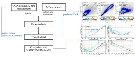
3. Method
3.1. Data Collocation
3.2. Data Preprocessing
3.3. Neural Network Design
4. Results
4.1. CVS Predictions
4.2. Influence of COD and p_top on CPT Prediction
4.2.1. Prediction Improvement with Different Inputs
4.2.2. Prediction Error with Different Input Variables
4.2.3. Analysis over Land and Ocean Surfaces
4.3. Comparison with OCO2CLD-LIDAR-AUX
5. Conclusions
Supplementary Materials
Author Contributions
Funding
Data Availability Statement
Acknowledgments
Conflicts of Interest
References
- Rossow, W.B.; Schiffer, R.A. Advances in understanding clouds from ISCCP. Bull. Am. Meteorol. Soc. 1999, 80, 2261–2288. [Google Scholar] [CrossRef]
- Stephens, G.L. Cloud feedbacks in the climate system: A critical review. J. Clim. 2005, 18, 237–273. [Google Scholar] [CrossRef] [Green Version]
- Yang, Q.; Fu, Q.; Hu, Y. Radiative impacts of clouds in the tropical tropopause layer. J. Geophys. Res. Atmos. 2010, 115, D00H12. [Google Scholar] [CrossRef] [Green Version]
- Stevens, B.; Bony, S. What are climate models missing? Science 2013, 340, 1053–1054. [Google Scholar] [CrossRef] [PubMed]
- George, G.; Sarangi, C.; Tripathi, S.N.; Chakraborty, T.; Turner, A. Vertical structure and radiative forcing of monsoon clouds over Kanpur during the 2016 INCOMPASS field campaign. J. Geophys. Res. Atmos. 2018, 123, 2152–2174. [Google Scholar] [CrossRef] [Green Version]
- Ravi Kiran, V.; Rajeevan, M.; Gadhavi, H.; Rao, S.V.B.; Jayaraman, A. Role of vertical structure of cloud microphysical properties on cloud radiative forcing over the Asian monsoon region. Clim. Dyn. 2015, 45, 3331–3345. [Google Scholar] [CrossRef]
- Li, J.; Yi, Y.; Minnis, P.; Huang, J.; Yan, H.; Ma, Y.; Wang, W.; Ayers, J.K. Radiative effect differences between multi-layered and single-layer clouds derived from CERES, CALIPSO, and CloudSat data. J. Quant. Spectrosc. Radiat. Transf. 2011, 112, 361–375. [Google Scholar] [CrossRef]
- Narendra Reddy, N.; Venkat Ratnam, M.; Basha, G.; Ravikiran, V. Cloud vertical structure over a tropical station obtained using long-term high-resolution radiosonde measurements. Atmos. Chem. Phys. 2018, 18, 11709–11727. [Google Scholar] [CrossRef] [Green Version]
- Jakob, C.; Klein, S.A. The role of vertically varying cloud fraction in the parametrization of microphysical processes in the ECMWF model. Q. J. R. Meteorol. Soc. 1999, 125, 941–965. [Google Scholar] [CrossRef]
- Yan, Y.; Liu, Y.; Lu, J. Cloud vertical structure, precipitation, and cloud radiative effects over Tibetan Plateau and its neighboring regions. J. Geophys. Res. Atmos. 2016, 121, 5864–5877. [Google Scholar] [CrossRef] [Green Version]
- Wang, J.; Rossow, W.B. Effects of cloud vertical structure on atmospheric circulation in the GISS GCM. J. Clim. 1998, 11, 3010–3029. [Google Scholar] [CrossRef]
- Weare, B.C. Insights into the importance of cloud vertical structure in climate. Geophys. Res. Lett. 2000, 27, 907–910. [Google Scholar] [CrossRef]
- Stephens, G.L.; Vane, D.G.; Boain, R.J.; Mace, G.G.; Sassen, K.; Wang, Z.; Illingworth, A.J.; O'connor, E.J.; Rossow, W.B.; Durden, S.L. The CloudSat mission and the A-Train: A new dimension of space-based observations of clouds and precipitation. Bull. Am. Meteorol. Soc. 2002, 83, 1771–1790. [Google Scholar] [CrossRef] [Green Version]
- Winker, D.M.; Hunt, W.H.; McGill, M.J. Initial performance assessment of CALIOP. Geophys. Res. Lett. 2007, 34, L19803. [Google Scholar] [CrossRef] [Green Version]
- Oreopoulos, L.; Cho, N.; Lee, D. New insights about cloud vertical structure from CloudSat and CALIPSO observations. J. Geophys. Res. Atmos. 2017, 122, 9280–9300. [Google Scholar] [CrossRef] [PubMed]
- Hanel, R.A. Determination of cloud altitude from a satellite. J. Geophys. Res. 1961, 66, 4. [Google Scholar] [CrossRef]
- Yamamoto, G.; Wark, D. Discussion of the letter by RA Hanel, “Determination of cloud altitude from a satellite”. J. Geophys. Res. 1961, 66, 3596. [Google Scholar] [CrossRef]
- Drouin, B.J.; Benner, D.C.; Brown, L.R.; Cich, M.J.; Crawford, T.J.; Devi, V.M.; Guillaume, A.; Hodges, J.T.; Mlawer, E.J.; Robichaud, D.J. Multispectrum analysis of the oxygen A-band. J. Quant. Spectrosc. Radiat. Transf. 2017, 186, 118–138. [Google Scholar] [CrossRef] [Green Version]
- Rozanov, V.V.; Kokhanovsky, A.A. Semianalytical cloud retrieval algorithm as applied to the cloud top altitude and the cloud geometrical thickness determination from top-of-atmosphere reflectance measurements in the oxygen A band. J. Geophys. Res. Atmos. 2004, 109, D05202. [Google Scholar] [CrossRef]
- Schuessler, O.; Rodriguez, D.G.L.; Doicu, A.; Spurr, R. Information Content in the Oxygen A-Band for the Retrieval of Macrophysical Cloud Parameters. IEEE Trans. Geosci. Remote Sens. 2013, 52, 3246–3255. [Google Scholar] [CrossRef] [Green Version]
- Kokhanovsky, A.A.; Rozanov, V.V. Cloud bottom altitude determination from a satellite. IEEE Geosci. Remote Sens. Lett. 2005, 2, 280–283. [Google Scholar] [CrossRef]
- Rozanov, V.V.; Kokhanovsky, A.A. Determination of cloud geometrical thickness using backscattered solar light in a gaseous absorption band. IEEE Geosci. Remote Sens. Lett. 2006, 3, 250–253. [Google Scholar] [CrossRef]
- Ferlay, N.; Thieuleux, F.; Cornet, C.; Davis, A.B.; Dubuisson, P.; Ducos, F.; Parol, F.; Riédi, J.; Vanbauce, C. Toward new inferences about cloud structures from multidirectional measurements in the oxygen A band: Middle-of-cloud pressure and cloud geometrical thickness from POLDER-3/PARASOL. J. Appl. Meteorol. Climatol. 2010, 49, 2492–2507. [Google Scholar] [CrossRef]
- Merlin, G.; Riedi, J.; Labonnote, L.C.; Cornet, C.; Davis, A.B.; Dubuisson, P.; Desmons, M.; Ferlay, N.; Parol, F. Cloud information content analysis of multi-angular measurements in the oxygen A-band: Application to 3MI and MSPI. Atmos. Meas. Tech. 2016, 9, 4977–4995. [Google Scholar] [CrossRef] [Green Version]
- Yang, Y.; Marshak, A.; Mao, J.; Lyapustin, A.; Herman, J. A method of retrieving cloud top height and cloud geometrical thickness with oxygen A and B bands for the Deep Space Climate Observatory (DSCOVR) mission: Radiative transfer simulations. J. Quant. Spectrosc. Radiat. Transf. 2013, 122, 141–149. [Google Scholar] [CrossRef]
- Richardson, M.; Leinonen, J.; Cronk, H.Q.; McDuffie, J.; Lebsock, M.D.; Stephens, G.L. Marine liquid cloud geometric thickness retrieved from OCO-2’s oxygen A-band spectrometer. Atmos. Meas. Tech. 2019, 12, 1717–1737. [Google Scholar] [CrossRef] [Green Version]
- Fischer, J.; Grassl, H. Detection of cloud-top height from backscattered radiances within the oxygen A band. Part 1: Theoretical study. J. Appl. Meteorol. Climatol. 1991, 30, 1245–1259. [Google Scholar] [CrossRef]
- Koelemeijer, R.; Stammes, P.; Hovenier, J.; De Haan, J. A fast method for retrieval of cloud parameters using oxygen A band measurements from the Global Ozone Monitoring Experiment. J. Geophys. Res. Atmos. 2001, 106, 3475–3490. [Google Scholar] [CrossRef] [Green Version]
- Stephens, G.L.; Heidinger, A. Molecular line absorption in a scattering atmosphere. Part I: Theory. J. Atmos. Sci. 2000, 57, 1599–1614. [Google Scholar] [CrossRef]
- Richardson, M.; Stephens, G.L. Information content of OCO-2 oxygen A-band channels for retrieving marine liquid cloud properties. Atmos. Meas. Tech. 2018, 11, 1515–1528. [Google Scholar] [CrossRef] [Green Version]
- Yang, J.; Li, S.; Gong, W.; Min, Q.; Mao, F.; Pan, Z. A fast cloud geometrical thickness retrieval algorithm for single-layer marine liquid clouds using OCO-2 oxygen A-band measurements. Remote Sens. Environ. 2021, 256, 112305. [Google Scholar] [CrossRef]
- Sun, K.; Liu, X.; Nowlan, C.R.; Cai, Z.; Chance, K.; Frankenberg, C.; Lee, R.A.; Pollock, R.; Rosenberg, R.; Crisp, D. Characterization of the OCO-2 instrument line shape functions using on-orbit solar measurements. Atmos. Meas. Tech. 2017, 10, 939–953. [Google Scholar] [CrossRef] [Green Version]
- Lee, R.A.; O’Dell, C.W.; Wunch, D.; Roehl, C.M.; Osterman, G.B.; Blavier, J.-F.; Rosenberg, R.; Chapsky, L.; Frankenberg, C.; Hunyadi-Lay, S.L. Preflight spectral calibration of the Orbiting Carbon Observatory 2. IEEE Trans. Geosci. Remote Sens. 2017, 55, 2499–2508. [Google Scholar] [CrossRef]
- Crisp, D. Measuring atmospheric carbon dioxide from space with the Orbiting Carbon Observatory-2 (OCO-2). Proc. Earth Obs. Syst. 2015, 9607, 960702. [Google Scholar]
- Wunch, D.; Wennberg, P.O.; Osterman, G.; Fisher, B.; Naylor, B.; Roehl, C.M.; O'Dell, C.; Mandrake, L.; Viatte, C.; Kiel, M. Comparisons of the orbiting carbon observatory-2 (OCO-2) X CO 2 measurements with TCCON. Atmos. Meas. Tech. 2017, 10, 2209–2238. [Google Scholar] [CrossRef] [Green Version]
- Eldering, A.; O'Dell, C.W.; Wennberg, P.O.; Crisp, D.; Gunson, M.R.; Viatte, C.; Avis, C.; Braverman, A.; Castano, R.; Chang, A. The Orbiting Carbon Observatory-2: First 18 months of science data products. Atmos. Meas. Tech. 2017, 10, 549–563. [Google Scholar] [CrossRef] [Green Version]
- Massie, S.T.; Sebastian Schmidt, K.; Eldering, A.; Crisp, D. Observational evidence of 3-D cloud effects in OCO-2 CO2 retrievals. J. Geophys. Res. Atmos. 2017, 122, 7064–7085. [Google Scholar] [CrossRef]
- Boesch, H.; Brown, L.; Castano, R.; Christi, M.; Connor, B.; Crisp, D.; Eldering, A.; Fisher, B.; Frankenberg, C.; Gunson, M. Orbiting Carbon Observatory (OCO)-2 Level 2 Full Physics Retrieval Algorithm Theoretical Basis Document; NASA JPL: Pasadena, CA, USA, 2015. [Google Scholar]
- Sassen, K.; Wang, Z.; Liu, D. Global distribution of cirrus clouds from CloudSat/Cloud-Aerosol lidar and infrared pathfinder satellite observations (CALIPSO) measurements. J. Geophys. Res. Atmos. 2008, 113, D00A12. [Google Scholar] [CrossRef]
- Sassen, K.; Wang, Z. Classifying clouds around the globe with the CloudSat radar: 1-year of results. Geophys. Res. Lett. 2008, 35, L04805. [Google Scholar] [CrossRef]
- Marchant, B.; Platnick, S.; Meyer, K.; Arnold, G.T.; Riedi, J. MODIS Collection 6 shortwave-derived cloud phase classification algorithm and comparisons with CALIOP. Atmos. Meas. Tech. 2016, 9, 1587–1599. [Google Scholar] [CrossRef] [Green Version]
- Platnick, S.; Meyer, K.G.; King, M.D.; Wind, G.; Amarasinghe, N.; Marchant, B.; Arnold, G.T.; Zhang, Z.; Hubanks, P.A.; Holz, R.E. The MODIS cloud optical and microphysical products: Collection 6 updates and examples from Terra and Aqua. IEEE Trans. Geosci. Remote Sens. 2016, 55, 502–525. [Google Scholar] [CrossRef] [Green Version]
- Taylor, T.E.; O’Dell, C.W.; Frankenberg, C.; Partain, P.T.; Cronk, H.Q.; Savtchenko, A.; Nelson, R.R.; Rosenthal, E.J.; Chang, A.Y.; Fisher, B. Orbiting Carbon Observatory-2 (OCO-2) cloud screening algorithms: Validation against collocated MODIS and CALIOP data. Atmos. Meas. Tech. 2016, 9, 973–989. [Google Scholar] [CrossRef] [Green Version]
- Saponaro, G.; Kolmonen, P.; Karhunen, J.; Tamminen, J.; de Leeuw, G. A neural network algorithm for cloud fraction estimation using NASA-Aura OMI VIS radiance measurements. Atmos. Meas. Tech. 2013, 6, 2301–2309. [Google Scholar] [CrossRef] [Green Version]
- Yu, W.; Xu, X.; Jin, S.; Ma, Y.; Liu, B.; Gong, W. BP neural network retrieval for remote sensing atmospheric profile of ground-based microwave radiometer. IEEE Geosci. Remote Sens. Lett. 2021, 19, 4502105. [Google Scholar] [CrossRef]
- Rodriguez, D.G.L.; Thomas, W.; Livschitz, Y.; Ruppert, T.; Albert, P.; Hollmann, R. Cloud properties derived from GOME/ERS-2 backscatter data for trace gas retrieval. IEEE Trans. Geosci. Remote Sens. 2007, 45, 2747–2758. [Google Scholar] [CrossRef]
- Loyola, D.; Koukouli, M.; Valks, P.; Balis, D.; Hao, N.; Van Roozendael, M.; Spurr, R.; Zimmer, W.; Kiemle, S.; Lerot, C. The GOME-2 total column ozone product: Retrieval algorithm and ground-based validation. J. Geophys. Res. Atmos. 2011, 116, D07302. [Google Scholar] [CrossRef]
- Loyola, D.G.; Gimeno García, S.; Lutz, R.; Argyrouli, A.; Romahn, F.; Spurr, R.J.; Pedergnana, M.; Doicu, A.; Molina García, V.; Schüssler, O. The operational cloud retrieval algorithms from TROPOMI on board Sentinel-5 Precursor. Atmos. Meas. Tech. 2018, 11, 409–427. [Google Scholar] [CrossRef] [Green Version]


| Number | Measurements or Products | Criterion |
|---|---|---|
| 1 | MYD06_L2 | Confidently or probably cloudy |
| 2 | MYD06_L2 | Existing values for cloud optical depth |
| 3 | MYD06_L2 and 2B-CLDCLASS-LIDAR | All liquid phase, CPR confidence level > 4 |
| 4 | 2B-CLDCLASS-LIDAR | Single-layer cloud |
| 5 | 2B-CLDCLASS | No precipitation |
| 6 | CAL_LID_L2_05kmALay | No above-cloud aerosol |
| Fields | Source | Input/Output |
|---|---|---|
| Cloud optical depth | MYD06_L2 | output |
| Cloud top pressure | 2B-CLDCLASS-LIDAR | output |
| Cloud pressure thickness | 2B-CLDCLASS-LIDAR | output |
| Surface pressure | ECMWF | input |
| Solar zenith angle | OCO-2 L1bSc | input |
| OCO-2 oxygen A-band radiance | OCO-2 L1bSc | input |
| Net Settings | Accuracy (Root Mean Square Error) | |||
|---|---|---|---|---|
| Hidden Layers | Nodes in Each Layer | COD | p_top | CPT |
| 2 | 200 | 7.31 | 35.06 hPa | 26.66 hPa |
| 2 | 300 | 7.35 | 33.88 hPa | 26.48 hPa |
| 3 | 200 | 7.48 | 34.48 hPa | 26.80 hPa |
| 2 | 100 | 7.36 | 36.84 hPa | 26.75 hPa |
| 1 | 200 | 7.46 | 39.37 hPa | 26.84 hPa |
| Experiment | COD | p_top | CPT |
|---|---|---|---|
| Model I | Output | Output | Output |
| Model II | Input | Output | Output |
| Model III | Output | Input | Output |
| Model IV | Input | Input | Output |
Disclaimer/Publisher’s Note: The statements, opinions and data contained in all publications are solely those of the individual author(s) and contributor(s) and not of MDPI and/or the editor(s). MDPI and/or the editor(s) disclaim responsibility for any injury to people or property resulting from any ideas, methods, instructions or products referred to in the content. |
© 2023 by the authors. Licensee MDPI, Basel, Switzerland. This article is an open access article distributed under the terms and conditions of the Creative Commons Attribution (CC BY) license (https://creativecommons.org/licenses/by/4.0/).
Share and Cite
Lei, Y.; Li, S.; Yang, J. A Machine Learning-Based Multiple Cloud Vertical Structure Parameter Prediction Algorithm Only Using OCO-2 Oxygen A-Band Measurements. Remote Sens. 2023, 15, 3142. https://doi.org/10.3390/rs15123142
Lei Y, Li S, Yang J. A Machine Learning-Based Multiple Cloud Vertical Structure Parameter Prediction Algorithm Only Using OCO-2 Oxygen A-Band Measurements. Remote Sensing. 2023; 15(12):3142. https://doi.org/10.3390/rs15123142
Chicago/Turabian StyleLei, Yixiao, Siwei Li, and Jie Yang. 2023. "A Machine Learning-Based Multiple Cloud Vertical Structure Parameter Prediction Algorithm Only Using OCO-2 Oxygen A-Band Measurements" Remote Sensing 15, no. 12: 3142. https://doi.org/10.3390/rs15123142