
Satellite-Based Methodology for Purposes of Rescue Archaeology of Cultural Heritage Threatened by Dam Construction


Abstract
: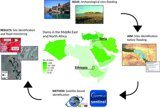
1. Introduction
2. Materials and Methods
2.1. Rationale
2.1.1. Multidisciplinary Collaboration
2.1.2. Open Access and “Tunable” Data
2.1.3. Variables for Data Selection
2.2. Workflow
2.3. Use-Cases
2.3.1. Planned Dam: Halabiyeh, Syria

2.3.2. Dam under Construction: GERD, Ethiopia

2.4. Satellite Data and Processing
3. Results
3.1. Halabiyeh Dam
3.2. Grand Ethiopian Renaissance Dam (GERD)
4. Discussion
4.1. Multidisciplinary Collaboration
- The workflow requires a continuous exchange of feedback between the satellite imagery analyst and archaeologist, which is proper of the co-working approach. Therefore, to properly perform this type of activity, it is always advisable to organize small teams with at least one expert for each required skill (e.g., image processing, site detection, landscape feature interpretation). However, the size of the teams may vary, depending on variables such as the expected reservoir dam dimension or the variability of the terrain. For small dams like Halabiyeh, a satellite imagery analyst and an archaeologist may be sufficient, while in the case of GERD, two or more figures covering each skill may be necessary. Alternatively, a longer period for data processing and analysis should be scheduled (see below).
- Considering the substantially different expertise of a satellite imagery analyst and an archaeologist, it is advisable that both the professional figures would already have a basic knowledge of the other’s subject or that they would receive basic training or introduction.
4.2. Data Acquisition
- Both the analyzed case studies confirmed the need to acquire satellite images over several seasons. In such circumstances, it is of the utmost importance that the PCARA begins at least two years before the final decision to commence the dam construction. Assuming that this timeframe is allowed, the first year would be dedicated to satellite image acquisition and archive building. During the first part of the second year, image processing and then remote sensing analysis would be carried out in order to provide preliminary mapping of potential sites. When permitted and feasible, ground-truthing activities would take place during the second half of the second year.
- In the case of tight deadlines or if the construction operations unexpectedly or suddenly accelerated, change detection analyses could not be performed, unless archive images were already available. The study of both Halabiyeh and GERD dams showed that most of the potential archaeological sites are generally identified by manual remote sensing using satellite imagery taken during humid periods. This evidence is confirmed by the analysis of both the Sentinel-2 false-colored infrared and COSMO-SkyMed StripMap imagery. Therefore, in cases of limited time or tight deadlines, it is possible to reduce acquisitions to humid seasons.
- In the case of GERD, Google Earth imagery was only partially helpful and could not support the assessment of damage to local heritage as it was possible to achieve with Sentinel-2 and COSMO-SkyMed. The available images did not record some key phases of the dam construction. Therefore, it was not possible to comprehensively reconstruct the recent history of the dam prior to its filling process without incurring in high uncertainty (see Figure 5). At the time when the satellite-based assessment was done and the present paper was completed, the Google Earth time-lapse did not include any satellite mosaic covering the whole study area at the same date of acquisition. Even the most recent satellite images collected at the end of 2020 were spatially limited to the area of the Main Dam and the Saddle Dam (see examples in Supplementary Materials, Figures S2–S4). This lack of imagery prevented a full assessment of the progressive flooding of villages and sites through PCARA to PFRAP protocols.
4.3. Variables
- There is no fixed rule for identifying sites that applies to any dam in any region, but it is necessary to know the geographic context to understand which variables may have greater relevance. The two cases of Halabiyeh and GERD dams have, in fact, shown how the potential sites have different characteristics based, among others, on the construction materials of the buildings (mudbrick vs. wood), and the shape of each site (rounded tell vs. irregular flatland). It is therefore essential, when carrying out this analysis, to be well acquainted with the distinctive architectural element(s) of the local ancient culture, the settlement and urban patterns, as well as any other visible physical element that is typical of that region (e.g., abandoned meanders).
- The two types of satellite images that were used in this study provide different levels of detail and types of information. In the case of COSMO-SkyMed, the possibility of modulating the spatial resolution is certainly an extremely advantageous feature, compared to the non-modifiable 10 m resolution baseline of Sentinel-2. The latter, however, is a good trade-off for a large variety of archaeological artefacts.
- The integrated use of COSMO-SkyMed and Sentinel-2 well suits the need for a rich temporal acquisition of satellite images. Indeed, if on the one hand Sentinel-2 guarantees a high acquisition frequency (except for the cloud cover as a random factor), on the other hand, COSMO-SkyMed allows for a remarkable tasking agility. We can also consider both the satellite assets to find observation solutions even in cases of tight deadlines and schedules. This makes COSMO-SkyMed and Sentinel-2 data more suitable than the open access images that are provided by Google Earth or other visualization platforms and used alone.
4.4. Workflow
- The workflow was tested on two case studies: a small-scale and a large-scale dam. In the case of a large-scale dam such as GERD, it is necessary to take into account (as mentioned above) the need for a larger team and/or a longer period for data processing and analysis. In the second case, it is therefore possible that the remote sensing activity may last up to one year.
- The workflow is designed to be also adapted by embedding other steps that should demonstrate necessary. An example is the addition of a fully automated or machine-assisted site identification step, associated with proper training on real site samples.
- The case of GERD dam also proves how the methodology is capable of flowing seamlessly from PCARA to PFRAP protocols, depending on the actual stage of the dam construction and the situation on the ground that is captured by satellite images, provided that the latter are regularly collected.
- Furthermore, from a purely technical point of view, a future outlook of the proposed methodology will consist in the integration of manual site identification with automated detection of signals and patterns extracted from different types of satellite imagery that can be used as proxies of archaeological features and sites. This well-established practice includes a rich literature and a wide array of algorithms specifically developed for this scope [5,64,70,87]. This future integration of rescue archaeology methodologies in the case of dam construction will provide a further step forward in the protection of cultural heritage.
5. Conclusions and Future Outlooks
Supplementary Materials
Author Contributions
Funding
Institutional Review Board Statement
Informed Consent Statement
Data Availability Statement
Acknowledgments
Conflicts of Interest
References
- Agapiou, A.; Alexakis, D.D.; Lysandrou, V.; Sarris, A.; Cuca, B.; Themistocleous, K.; Hadjimitsis, D.G. Impact of Urban Sprawl to Cultural Heritage Monuments: The Case Study of Paphos Area in Cyprus. J. Cult. Herit. 2015, 16, 671–680. [Google Scholar] [CrossRef]
- Agapiou, A.; Lysandrou, V.; Hadjimitsis, D.G. Earth Observation Contribution to Cultural Heritage Disaster Risk Management: Case Study of Eastern Mediterranean Open Air Archaeological Monuments and Sites. Remote Sens. 2020, 12, 1330. [Google Scholar] [CrossRef] [Green Version]
- Agapiou, A. Multi-Temporal Change Detection Analysis of Vertical Sprawl over Limassol City Centre and Amathus Archaeological Site in Cyprus during 2015–2020 Using the Sentinel-1 Sensor and the Google Earth Engine Platform. Sensors 2021, 21, 1884. [Google Scholar] [CrossRef] [PubMed]
- Tapete, D.; Cigna, F. Detection of Archaeological Looting from Space: Methods, Achievements and Challenges. Remote Sens. 2019, 11, 2389. [Google Scholar] [CrossRef] [Green Version]
- Luo, L.; Wang, X.; Guo, H.; Lasaponara, R.; Shi, P.; Bachagha, N.; Li, L.; Yao, Y.; Masini, N.; Chen, F.; et al. Google Earth as a Powerful Tool for Archaeological and Cultural Heritage Applications: A Review. Remote Sens. 2018, 10, 1558. [Google Scholar] [CrossRef]
- Cuca, B.; Hadjimitsis, D.G. Space Technology Meets Policy: An Overview of Earth Observation Sensors for Monitoring of Cultural Landscapes within Policy Framework for Cultural Heritage. J. Archaeol. Sci. Rep. 2017, 14, 727–733. [Google Scholar] [CrossRef] [Green Version]
- Lasaponara, R.; Masini, N. (Eds.) Satellite Remote Sensing: A New Tool for Archaeology; Springer International Publishing: New York, NY, USA, 2012. [Google Scholar]
- Parcak, S. Satellite Remote Sensing for Archaeology; Routledge: London, UK, 2009. [Google Scholar]
- Hadjimitsis, D.G.; Themistocleous, K.; Cuca, B.; Agapiou, A.; Lysandrou, V.; Lasaponara, R.; Masini, N.; Schreier, G. (Eds.) Remote Sensing for Archaeology and Cultural Landscapes: Best Practices and Perspectives Across Europe and the Middle East; Springer International Publishing: New York, NY, USA, 2020; ISBN 978-3-030-10978-3. [Google Scholar]
- Zaina, F. A Risk Assessment for Cultural Heritage in Southern Iraq: Framing Drivers, Threats and Actions Affecting Archaeological Sites. Conserv. Manag. Archaeol. Sites 2019, 21, 184–206. [Google Scholar] [CrossRef]
- Zaina, F.; Nabati Mazloumi, Y. A Multi-temporal Satellite-based Risk Analysis of Archaeological Sites in Qazvin Plain (Iran). Archaeol. Prospect. 2021, 28, 467–483. [Google Scholar] [CrossRef]
- UNESCO. Managing Disaster Risks; UNESCO: Paris, France, 2010; Volume 1, ISBN 978-92-3-104165-5. [Google Scholar]
- Global Heritage Fund. Saving Our Vanishing Heritage: Safeguarding Endangered Cultural Heritage Sites in the Developing World; Global Heritage Fund: Palo Alto, CA, USA, 2010. [Google Scholar]
- Stovel, H. Risk Preparedness: A Management Manual for World Cultural Heritage; ICCROM: Rome, Italy, 1998; ISBN 92-9077-152-6. [Google Scholar]
- Rayne, L.; Bradbury, J.; Mattingly, D.; Philip, G.; Bewley, R.; Wilson, A. From Above and on the Ground: Geospatial Methods for Recording Endangered Archaeology in the Middle East and North Africa. Geosciences 2017, 7, 100. [Google Scholar] [CrossRef] [Green Version]
- Casana, J. Satellite Imagery-Based Analysis of Archaeological Looting in Syria. East. Archaeol. 2015, 78, 142–152. [Google Scholar] [CrossRef] [Green Version]
- Stone, E.C. An Update on the Looting of Archaeological Sites in Iraq. East. Archaeol. 2015, 78, 178–186. [Google Scholar] [CrossRef] [Green Version]
- Lauricella, A.; Cannon, J.; Branting, S.; Hammer, E. Semi-Automated Detection of Looting in Afghanistan Using Multispectral Imagery and Principal Component Analysis. Antiquity 2017, 91, 1344–1355. [Google Scholar] [CrossRef]
- Reimann, L.; Vafeidis, A.T.; Brown, S.; Hinkel, J.; Tol, R.S.J. Mediterranean UNESCO World Heritage at Risk from Coastal Flooding and Erosion Due to Sea-Level Rise. Nat. Commun. 2018, 9, 4161. [Google Scholar] [CrossRef] [Green Version]
- Harmanşah, Ö. ISIS, Heritage, and the Spectacles of Destruction in the Global Media. East. Archaeol. 2015, 78, 170–177. [Google Scholar] [CrossRef]
- Stanley-Price, N. (Ed.) Cultural Heritage in Postwar Recovery. Papers from the ICCROM FORUM Held on October 4–6; International Centre for the Study of the Preservation and Restoration of Cultural Property: Rome, Italy, 2005; ISBN 92-9077-201-8. [Google Scholar]
- Hammer, E.; Seifried, R.; Franklin, K.; Lauricella, A. Remote Assessments of the Archaeological Heritage Situation in Afghanistan. J. Cult. Herit. 2018, 33, 125–144. [Google Scholar] [CrossRef] [Green Version]
- Cunliffe Archaeological Site Damage in the Cycle of War and Peace. J. East. Mediterr. Archaeol. Herit. Stud. 2014, 2, 229. [CrossRef]
- Casana, J.; Laugier, E.J. Satellite Imagery-Based Monitoring of Archaeological Site Damage in the Syrian Civil War. PLoS ONE 2017, 12, e0188589. [Google Scholar] [CrossRef] [Green Version]
- Mantellini, S.; Berdimuradov, A.E. Evaluating the Human Impact on the Archaeological Landscape of Samarkand (Uzbekistan): A Diachronic Assessment of the Taylak District by Remote Sensing, Field Survey, and Local Knowledge. Archaeol. Res. Asia 2019, 20, 100143. [Google Scholar] [CrossRef]
- Nebbia, M.; Cilio, F.; Bobomulloev, B. Spatial Risk Assessment and the Protection of Cultural Heritage in Southern Tajikistan. J. Cult. Herit. 2021, 49, 183–196. [Google Scholar] [CrossRef]
- Hamilton, D.L. Methods of Conserving Archaeological Material from Underwater Sites; Texas A&M University: College Station, TX, USA, 1999. [Google Scholar]
- Yang, F.; Xu, F.; Zhang, K.; Bu, X.; Hu, H.; Anokye, M. Characterisation of Terrain Variations of an Underwater Ancient Town in Qiandao Lake. Remote Sens. 2020, 12, 268. [Google Scholar] [CrossRef] [Green Version]
- Stammitti, E. Cross-Cultural Analysis of the Policy, Application and Effect of Legislation Concerning Archaeological Sites in Reservoirs, and Implications for Future Reservoir Works and Site Monitoring; The University of Edinburgh: Edinburgh, Scotland, 2015. [Google Scholar]
- Lenihan, D. The Final Report of the National Reservoir Inundation Study; United States Department of Interior: Santa Fe, NM, USA, 1981; Volume 1.
- Marchetti, N. Archaeology and Dams in Southeastern Turkey: Post-Flooding Damage Assessment and Safeguarding Strategies on Cultural Heritage. J. Mediterr. Archaeol. 2020, 33, 29–54. [Google Scholar] [CrossRef]
- Cunliffe, E.L.; de Gruchy, M.W.; Stammitti, E. How to Build a Dam and Save Cultural Heritage. Int. J. Herit. Digit. Era 2012, 1, 221–226. [Google Scholar] [CrossRef] [Green Version]
- Cunliffe, E.; de Gruchy, M.; Stammitti, E. Project Development - Dam(Ned) Archaeology. Int. Water Power Dam Constr. 2012, 64, 9. [Google Scholar]
- Marchetti, N.; Curci, A.; Gatto, M.C.; Nicolini, S.; Mühl, S.; Zaina, F. A Multi-Scalar Approach for Assessing the Impact of Dams on the Cultural Heritage in the Middle East and North Africa. J. Cult. Herit. 2019, 37, 17–28. [Google Scholar] [CrossRef]
- Titolo, A. Use of Time-Series NDWI to Monitor Emerging Archaeological Sites: Case Studies from Iraqi Artificial Reservoirs. Remote Sens. 2021, 13, 786. [Google Scholar] [CrossRef]
- Näser, C.; Kleinitz, C. The Good, the Bad and the Ugly: A Case Study on the Politicisation of Archaeology and Its Consequences from Northern Sudan. In Nihna nâs al-Bahar—We Are the People of the River; Kleinitz, C., Näser, C., Eds.; Meroitica; Harrasowitz: Wiesbaden, Germany, 2012; pp. 183–196. [Google Scholar]
- EIAR. Environmental Impact Assessment Report for the Ilısu Dam and HEPP; GAP: Ankara, Turkey, 2000. [Google Scholar]
- Shen, C.; Brandt, S.; Fekri, H. Mission Impossible: Archaeology of the Three Gorges Reservoir, China. In Dams and Cultural Heritage Management; World Commission on Dams: Cape Town, South Africa, 2000; pp. 53–58. [Google Scholar]
- Ponseti, M.; López-Pujol, J. The Three Gorges Dam Project in China: History and Consequences. HMiC Història Mod. Contemp. 2006, 4, 151–188. [Google Scholar]
- Banks, K.M.; Signe Snortland, J.; Czaplicki, J. The Price We’ve Paid: From Salvage Archaeology to Cultural Resource Management and Beyond in the Missouri River Basin. Plains Anthropol. 2011, 56, 371–385. [Google Scholar] [CrossRef]
- Fernea, R. Thirty Years of Resettlement: The Nubians in Egypt. Cent. Migr. Stud. Spec. Issues 1994, 11, 156–158. [Google Scholar] [CrossRef]
- Hopkins, N.S.; Mehanna, S.R. Nubian Encounters: The Story of the Nubian Ethnological Survey 19611964.; Oxford University Press: Oxford, UK, 2011. [Google Scholar]
- Heggelund, G. Resettlement Programmes and Environmental Capacity in the Three Gorges Dam Project. Dev. Chang. 2006, 37, 179–199. [Google Scholar] [CrossRef]
- White, G. The Environmental Effects of the High Dam at Aswan. Environ. Sci. Policy Sustain. Dev. 1988, 30, 4–40. [Google Scholar] [CrossRef]
- Zeid, A.M. Environmental Impacts of the Aswan High Dam: A Case Study. Int. J. Water Resour. Dev. 1989, 5, 147–157. [Google Scholar] [CrossRef]
- Brewitt, P.K.; Colwyn, C.L.M. Little Dams, Big Problems: The Legal and Policy Issues of Nonjurisdictional Dams. WIREs Water 2020, 7, e1393. [Google Scholar] [CrossRef]
- Shoup, D. Can Archaeology Build a Dam? Sites and Politics in Turkey’s Southeast Anatolia Project. J. Mediterr. Archaeol. 2007, 19, 231–258. [Google Scholar] [CrossRef]
- Arthur, C.; Mohapi, M.; Mitchell, P. Archaeology and Dam Projects in Lesotho. Conserv. Manag. Archaeol. Sites 2011, 13, 231–252. [Google Scholar] [CrossRef]
- Akyürek, K. Impact of Atatürk Dam on Social and Environmental Aspects of the Southeastern Anatolia Project. Master’s Thesis, Middle East Technical University, Ankara, Turkey, 2005. [Google Scholar]
- Brandt, S.; Hassan, F. (Eds.) Dams and Cultural Heritage Management; World Commission on Dams: Cape Town, South Africa, 2000. [Google Scholar]
- Silva, A.C. Cultural Heritage Management and Dams: The Portuguese Case and The Dam Of Alqueva (Alentejo). In Dams and Cultural Heritage Management; Brandt, S., Hassan, F., Eds.; World Commission on Dams: Cape Town, South Africa, 2000; pp. 47–49. [Google Scholar]
- Derevianko, A.; Brandt, S.; Hassan, F. CHM and Dams in Siberia. In Dams and Cultural Heritage Management; World Commission on Dams: Cape Town, South Africa, 2000; pp. 48–52. [Google Scholar]
- Kinahan, J. Lessons From The Joint Angolan-Namibian Lower Cunene Hydropower Scheme. In Dams and Cultural Heritage Management; Brandt, S., Hassan, F., Eds.; World Commission on Dams: Cape Town, South Africa, 2000; pp. 28–30. [Google Scholar]
- European Union Environmental Impact Assessment. Off. J. Eur. Communities 1985, 175, 1–9.
- World Bank. 1986 Management of Cultural Property in Bank- Financed Projects; Operational Policy Note 11.03; World Bank: Washington, DC, USA, 1986. [Google Scholar]
- Demoule, J.P. Rescue Archaeology: An European View. Annu. Rev. Anthropol. 2012, 41, 611–626. [Google Scholar] [CrossRef]
- Horňák, M.; Guermandi, M.P.; Stäuble, H.; Depaepe, P.; Novaković, P.; Demoule, J.-P. (Eds.) European Association of Archaeologists. In Recent Developments in Preventive Archaeology in Europe: Proceedings of the 22nd EAA Meeting in Vilnius, 201, 1st ed.; Birografika Bori: Ljubljana, Slovenia, 2016; ISBN 978-961-237-887-5. [Google Scholar]
- Tapete, D.; Cigna, F. Trends and Perspectives of Space-Borne SAR Remote Sensing for Archaeological Landscape and Cultural Heritage Applications. J. Archaeol. Sci. Rep. 2017, 14, 716–726. [Google Scholar] [CrossRef] [Green Version]
- Agapiou, A.; Lysandrou, V. Remote Sensing Archaeology: Tracking and Mapping Evolution in European Scientific Literature from 1999 to 2015. J. Archaeol. Sci. Rep. 2015, 4, 192–200. [Google Scholar] [CrossRef]
- Campana, S. ‘Total Archaeology’ to Reduce the Need for Rescue Archaeology: The BREBEMI Project (Italy). In Proceedings of the 11th EAC Heritage Management Symposium, Reykjavík, Iceland, 25–27 March 2010; Cowley, D., Ed.; Europae Archaeologia Consilium: Bruxelles, Belgium, 2011; Volume 5. [Google Scholar]
- Parcak, S.H. GIS, Remote Sensing, and Landscape Archaeology; Oxford University Press: Oxford, UK, 2017; Volume 1. [Google Scholar]
- Tapete, D.; Cigna, F. Appraisal of Opportunities and Perspectives for the Systematic Condition Assessment of Heritage Sites with Copernicus Sentinel-2 High-Resolution Multispectral Imagery. Remote Sens. 2018, 10, 561. [Google Scholar] [CrossRef] [Green Version]
- Agapiou, A. Remote Sensing Heritage in a Petabyte-Scale: Satellite Data and Heritage Earth Engine© Applications. Int. J. Digit. Earth 2017, 10, 85–102. [Google Scholar] [CrossRef] [Green Version]
- Liss, B.; Howland, M.D.; Levy, T.E. Testing Google Earth Engine for the Automatic Identification and Vectorization of Archaeological Features: A Case Study from Faynan, Jordan. J. Archaeol. Sci. Rep. 2017, 15, 299–304. [Google Scholar] [CrossRef] [Green Version]
- ESA User Guides—Sentinel-1 SAR—Level-1 Ground Range Detected—Sentinel Online—Sentinel Online. Available online: https://Sentinels.Copernicus.Eu/Web/Sentinel/User-Guides/Sentinel-1-Sar2022 (accessed on 17 January 2022).
- Tapete, D.; Cigna, F. InSAR Data for Geohazard Assessment in UNESCO World Heritage Sites: State-of-the-Art and Perspectives in the Copernicus Era. Int. J. Appl. Earth Obs. Geoinform. 2017, 63, 24–32. [Google Scholar] [CrossRef]
- Cuca, B. Copernicus Sentinel Imagery for More Risk-Resilient Historic Cities in Coastal Zones: Contribution to the Monitoring of Albenga Archaeological Site and Delta of River Centa. Appl. Geomat. 2020, 12. [Google Scholar] [CrossRef]
- Tapete, D.; Cigna, F. Poorly Known 2018 Floods in Bosra UNESCO Site and Sergiopolis in Syria Unveiled from Space Using Sentinel-1/2 and COSMO-SkyMed. Sci. Rep. 2020, 10, 12307. [Google Scholar] [CrossRef]
- Tapete, D.; Cigna, F. Mapping Impact of Urbanization in Shahat-Cyrene (Libya) Using a Big SAR Data Approach of Change Detection with COSMO-SkyMed Time Series. IOP Conf. Ser. Earth Environ. Sci. 2020, 509, 012056. [Google Scholar] [CrossRef]
- Orengo, H.A.; Conesa, F.C.; Garcia-Molsosa, A.; Lobo, A.; Green, A.S.; Madella, M.; Petrie, C.A. Automated Detection of Archaeological Mounds Using Machine-Learning Classification of Multisensor and Multitemporal Satellite Data. Proc. Natl. Acad. Sci. USA 2020, 117, 18240–18250. [Google Scholar] [CrossRef]
- Tapete, D.; Traviglia, A.; Delpozzo, E.; Cigna, F. Regional-Scale Systematic Mapping of Archaeological Mounds and Detection of Looting Using COSMO-SkyMed High Resolution DEM and Satellite Imagery. Remote Sens. 2021, 13, 3106. [Google Scholar] [CrossRef]
- Tapete, D.; Cigna, F. COSMO-SkyMed SAR for Detection and Monitoring of Archaeological and Cultural Heritage Sites. Remote Sens. 2019, 11, 1326. [Google Scholar] [CrossRef] [Green Version]
- United Nations Development Programme. Reviving the Business Climate and Boosting Tourism in Deir Ezzor; Government of the Syrian Arab Republic State Planning Commission & the United Nations Development Programme: Washington, DC, USA, 2008. [Google Scholar]
- Montero Fenollos, J.L. Le Défilé de Khanuqa: Géographie et Histoire Au Moyen Euphrate Méridional. ISIMU 2011, 13, 125–136. [Google Scholar]
- Montero Fenollos, J.L. Mari et Le Verrou de Khanuqa: Frontière Politique et Territoire Aux IIIe et IIe Millénaires Av. J.-C. Syria 2014, 91, 231–245. [Google Scholar]
- Banning, E.B.; Hawkins, A.L.; Stewart, S.T.; Hitchings, P.; Edwards, S. Quality Assurance in Archaeological Survey. J. Archaeol. Method Theory 2017, 24, 466–488. [Google Scholar] [CrossRef] [Green Version]
- Mohamed, M.M.; Elmahdy, S.I. Remote Sensing of the Grand Ethiopian Renaissance Dam: A Hazard and Environmental Impacts Assessment. Geomat. Nat. Hazards Risk 2017, 8, 1225–1240. [Google Scholar] [CrossRef] [Green Version]
- Madson, A.; Sheng, Y. Reservoir Induced Deformation Analysis for Several Filling and Operational Scenarios at the Grand Ethiopian Renaissance Dam Impoundment. Remote Sens. 2020, 12, 1886. [Google Scholar] [CrossRef]
- Kansara, P.; Li, W.; El-Askary, H.; Lakshmi, V.; Piechota, T.; Struppa, D.; Abdelaty Sayed, M. An Assessment of the Filling Process of the Grand Ethiopian Renaissance Dam and Its Impact on the Downstream Countries. Remote Sens. 2021, 13, 711. [Google Scholar] [CrossRef]
- El-Askary, H.; Fawzy, A.; Thomas, R.; Li, W.; LaHaye, N.; Linstead, E.; Piechota, T.; Struppa, D.; Sayed, M.A. Assessing the Vertical Displacement of the Grand Ethiopian Renaissance Dam during Its Filling Using DInSAR Technology and Its Potential Acute Consequences on the Downstream Countries. Remote Sens. 2021, 13, 4287. [Google Scholar] [CrossRef]
- González-Ruibal Etnoarqueología de La Cerámica En El Oeste de Etiopía. Trab. Prehist. 2005, 6, 41–66.
- González-Ruibal, A. The Dream of Reason: An Archaeology of the Failures of Modernity in Ethiopia. J. Soc. Archaeol. 2006, 6, 175–201. [Google Scholar] [CrossRef]
- González-Ruibal, A.; Martínez, V.M.F. Exhibiting Cultures in Contact: A Museum for Benishangul-Gumuz, Ethiopia. Stanf. J. Archaeol. 2007, 5, 18–19. [Google Scholar]
- Tapete, D.; Cigna, F.; Donoghue, D.N.M. ‘Looting Marks’ in Space-Borne SAR Imagery: Measuring Rates of Archaeological Looting in Apamea (Syria) with TerraSAR-X Staring Spotlight. Remote Sens. Environ. 2016, 178, 42–58. [Google Scholar] [CrossRef] [Green Version]
- Elsayed, H.; Djordjević, S.; Savić, D.A.; Tsoukalas, I.; Makropoulos, C. The Nile Water-Food-Energy Nexus under Uncertainty: Impacts of the Grand Ethiopian Renaissance Dam. J. Water Resour. Plan. Manag. 2020, 146, 04020085. [Google Scholar] [CrossRef]
- Bombelli, G.; Tomiet, S.; Bianchi, A.; Bocchiola, D. Impact of Prospective Climate Change Scenarios upon Hydropower Potential of Ethiopia in GERD and GIBE Dams. Water 2021, 13, 716. [Google Scholar] [CrossRef]
- Davis, D.S.; Lipo, C.P.; Sanger, M.C. A Comparison of Automated Object Extraction Methods for Mound and Shell-Ring Identification in Coastal South Carolina. J. Archaeol. Sci. Rep. 2019, 23, 166–177. [Google Scholar] [CrossRef]


| Satellite Type | Satellite Name | Imaging Mode | Spatial Resolution | Acquisition Date | Season |
|---|---|---|---|---|---|
| SAR | COSMO-SkyMed | StripMap HIMAGE | 3 m | 1, 4, 5, 13 May 2021 | Dry |
| 9, 28 November 2021 | Humid | ||||
| 7, 23 December 2021 | Humid | ||||
| Enhanced Spotlight | 1 m | 14 January 2012 | Dry | ||
| 2, 9, 10 May 2021 | Dry | ||||
| 2, 10, 17 November 2021 | Humid | ||||
| 28 December 2021 | Humid | ||||
| Multispectral | Sentinel-2 | L2A (BOA) | 10 m (RGB, NIR bands) | 25 May 2017 | Dry |
| 30 January 2018 | Dry | ||||
| 21 March 2019 | Humid | ||||
| 31 August 2019 | Humid | ||||
| 29 September 2020 | Humid | ||||
| 2, 4, 7, 9, 14, 19 May 2021 | Dry | ||||
| 3, 13, 18, 23 November 2021 | Humid |
| Satellite Type | Satellite Name | Imaging Mode | Spatial Resolution | Acquisition Date | Season | Dam Construction |
|---|---|---|---|---|---|---|
| SAR | COSMO- SkyMed | StripMap HIMAGE | 3 m | 7 July 2013 | Humid | During (early stage) |
| 3 October 2016 | Humid | During | ||||
| 5–30 May 2021 | Dry | Post | ||||
| 5, 13, 25, 29 October 2021, 10 November 2021 | Humid to dry | Post | ||||
| Multi- spectral | Sentinel-2 | L1C (TOA) | 10 m (RGB, NIR bands) | 28 August 2016 | Humid | During |
| 7 October 2016 | Humid | During | ||||
| 25 January 2017 | Dry | During | ||||
| 28 August 2018 | Humid | During (late stage) | ||||
| L2A (BOA) | 10 m (RGB, NIR bands) | 29 May 2021 | Dry | Post | ||
| 3, 13 July 2021 | Humid | Post (second filling) | ||||
| 7 August 2021 | Humid | Post | ||||
| 16, 26 October 2021, 5 November 2021 | Humid to dry | Post |
Publisher’s Note: MDPI stays neutral with regard to jurisdictional claims in published maps and institutional affiliations. |
© 2022 by the authors. Licensee MDPI, Basel, Switzerland. This article is an open access article distributed under the terms and conditions of the Creative Commons Attribution (CC BY) license (https://creativecommons.org/licenses/by/4.0/).
Share and Cite
Zaina, F.; Tapete, D. Satellite-Based Methodology for Purposes of Rescue Archaeology of Cultural Heritage Threatened by Dam Construction. Remote Sens. 2022, 14, 1009. https://doi.org/10.3390/rs14041009
Zaina F, Tapete D. Satellite-Based Methodology for Purposes of Rescue Archaeology of Cultural Heritage Threatened by Dam Construction. Remote Sensing. 2022; 14(4):1009. https://doi.org/10.3390/rs14041009
Chicago/Turabian StyleZaina, Federico, and Deodato Tapete. 2022. "Satellite-Based Methodology for Purposes of Rescue Archaeology of Cultural Heritage Threatened by Dam Construction" Remote Sensing 14, no. 4: 1009. https://doi.org/10.3390/rs14041009