Article

Identifying High Stranding Risk Areas of the Yangtze Finless Porpoise via Remote Sensing and Hydrodynamic Modeling

1
College of Geography and Environment, Jiangxi Normal University, Nanchang 330022, China
2
The Key Laboratory of Poyang Lake Wetland and Watershed Research, Ministry of Education, Jiangxi Normal University, Nanchang 330022, China
3
Department of Agriculture and Rural Affairs of Jiangxi Province, Nanchang 330000, China
*
Author to whom correspondence should be addressed.
Remote Sens. 2022, 14(10), 2455; https://doi.org/10.3390/rs14102455
Submission received: 15 April 2022 / Revised: 13 May 2022 / Accepted: 19 May 2022 / Published: 20 May 2022

Abstract

:
Freshwater cetaceans that inhabit river basins with seasonally changing hydrological regimes have a higher risk of stranding, leading to increased mortality and population decline. In Poyang Lake, the stranding risk of the critically endangered Yangtze finless porpoise are high, due to the significant differences in hydrological and landscape conditions between the flood and dry seasons. However, this stranding information is not well recorded, resulting in poorly guided investigation and rescue efforts. We here employ remote sensing and hydrodynamic modeling to obtain four evaluation indicators in dry, normal, and flood scenarios in Poyang Lake. Results show that nearly 50% of the largest habitat range of the porpoises in the flood season will be land areas during the dry season, and that landscape fragmentation between land and water has increased over the past three decades. In all scenarios, the mean water depth of the habitat varied from 1.77 to 4.89 m from September–February. In the dry scenario, about 59% of the habitat experiences a water depth of <1 m within 15 days. The high stranding risk area is 284.54 km2 in the dry scenario, >251.04 km2 in the normal scenario, and >90.12 km2 in the flood scenario. High-stranding risk areas are located within city boundaries, where porpoise stranding cases have been recorded, especially in Duchang, which has the most high-risk areas in all scenarios. In all scenarios, the high stranding risk area has an average bathymetry of 7.81 m and an average water depth between 1.75 and 5.54 m. Our results can guide future investigations to establish sound stranding networks, and the methods proposed here are also applicable to studies of other freshwater cetaceans facing severe stranding risk.

1. Introduction

Cetaceans are apex predators in freshwater and ocean systems, and they can indicate the biodiversity and sustainability of aquatic ecosystems [1,2]. Some of these vulnerable species are experiencing population decline and habitat degradation due to climate change and increasing anthropogenic impacts such as shipping, fishing, pollution, and coastal maritime engineering [3]. Due to their tendency to stay underwater for extended periods and their slow life histories, it is difficult to directly determine the threats of environmental conditions to cetaceans [4]. Stranding records are critical in revealing elusive information about extant cetacean communities [5]. However, only long-term stranding data sets of marine cetaceans have been recorded and studied globally [6]. Proximal factors causing marine cetacean stranding are extreme weather conditions, geomagnetic storms, military sonar, and physical contact with ships [5]. Freshwater cetaceans inhabit some large river basins, and the main threats they face come from increasing human activities, such as artificial control of water flow and overfishing [7]. In addition, the dry season (or low-water season) is the most challenging period for freshwater cetacean protection due to the limited habitats [8]. This is especially true for cetaceans which inhabit river basins in Asia, as their patchy distribution patterns and specific environmental preferences can greatly increase the risk of stranding in shallow waters during dry seasons [9]. Thus, identifying the high stranding risk areas for freshwater cetaceans is critical, such as the Indus River dolphin (Platanista gangetica minor), Ganges River Dolphin (Platanista gangetica gangetica), Irrawaddy dolphin (Orcaella brevirostiris), and the Yangtze finless porpoise (Neophocaena asiaeorientalis asiaeorientalis) [10,11].
The Yangtze finless porpoise is currently the only freshwater cetacean that can be found in the Yangtze River Basin (Figure 1) of China [12], and it is critically endangered, with a wild population of around 1012 [13]. The Yangtze River Basin is one of the most anthropogenically-modified freshwater systems globally [14]. The degradation of its habitats has caused the porpoise population to decline and be unevenly distributed along the middle and lower reaches of the Yangtze River [15]. Poyang Lake (Figure 1) is a large seasonal freshwater lake naturally connected to the Yangtze River, which maintains a stable population of about 450 porpoises [16]. Influenced by a subtropical monsoon climate, the inundation area of Poyang Lake fluctuates between ~1000 km2 in the dry season and ~3000 km2 in the flood season [17]. However, the likely habitat of the porpoise (Figure 2) occupies a small area of the lake inundation area, especially during the dry season [11]. During the past decades, stranding and overfishing have been the leading causes of porpoise deaths, and a large part of them occurred in Poyang Lake [18]. Beginning in 2020, the implementation of a “10-year fishing ban” will reduce the threat of fishing to the life history of the porpoises [19].
During 2008 and 2020, nearly 70% of the porpoises whose death dates were recorded in Poyang Lake died in the transitional season (September–October) and dry season (November–February, unpublished data from Department of Agriculture and Rural Affairs of Jiangxi Province). The flood season of Poyang Lake generally ends in August. After August, the water level declines rapidly, and large areas of land are exposed. The dry season begins in November, revealing a complex wetland system consisting of grasslands, mudflats, sandbars, and water channels [17]. Therefore, as the water level continues to decline, the risk of the porpoises being trapped and stranded in these wetland landscapes also increases.
Understanding long-term changes in wetland landscapes and hydrological regimes are two critical steps to assess the Yangtze finless porpoise stranding risk within Poyang Lake habitats. Remote sensing is a versatile method for monitoring changes in wetland landscapes [20,21]. Remote sensing can provide foundational information of surface cover characteristics through long-term time series observations, especially for wetlands with high human disturbance intensity and unstable natural conditions, such as rivers and coastlines [22,23]. Hydrodynamic models can effectively simulate hydrological regimes and water quality of freshwater or marine systems [11]. We here combine remote sensing and hydrodynamic modeling to identify the high stranding risk areas of the porpoise in Poyang Lake. In Section 2, we detail the methods of landscape extraction and hydrodynamic modeling within the porpoise habitat and introduce the construction of a stranding risk assessment model. Landscape features within the habitat, hydrological regimes, and the level of stranding risk are presented in Section 3. Section 4 discusses the main results of this paper from four aspects.

2. Materials and Methods

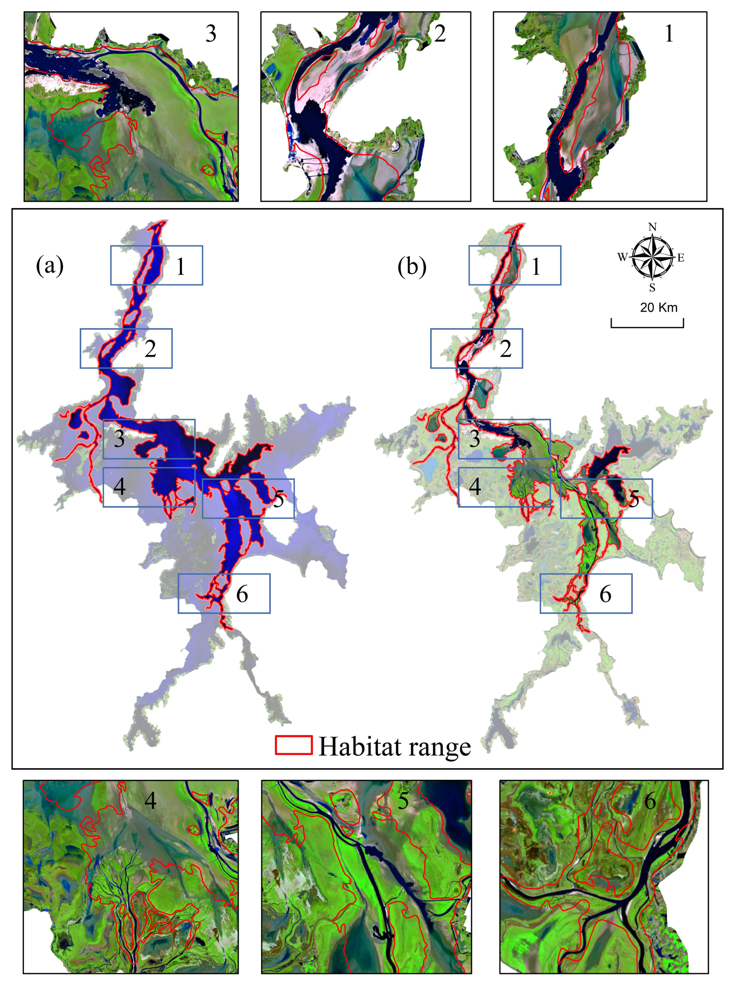
2.1. Likely Habitats of The Yangtze Finless Porpoise

The maximum range of the Yangtze finless porpoise habitat in Poyang Lake was analyzed in a previous study [11] that applied a species distribution model. The maximum habitat range for the porpoise is the area found during the flood season, with an area of 880 km2 (Figure 2). The habitat is continuously distributed from the southern tributary estuary to the northern waterway, which connects to the Yangtze River. The habitat is an entirely inundated area during the wet season and transforms into a complex system formed by terrestrial landscapes and water during the dry season (Figure 2).

2.2. Wetland Landscape Extraction

We selected a total of 31 scenes of Landsat Thematic Mapper (TM), Enhanced Thematic Mapper Plus (ETM+), and Operational Land Imager (OLI) images from 1990 to 2020 acquired by Landsat satellite under clear weather in the dry season (Path121, Row 040, https://earthexplorer.usgs.gov/, accessed on 1 February 2020) to identify which areas within porpoise transition habitats will surface and form different wetland landscapes in the dry season. All images were corrected by the FLASH module in the ENVI 5.3 software by using the mid-latitude winter model to correct for atmospheric surface reflectance [24]. The wetland system of Poyang Lake during the dry season is mainly composed of water, grassland, mudflats, and sandbars. We used a support vector machine (SVM) method to extract the above four types of landscapes [25]. Then, the vector data of the four wetland landscapes in the habitat range during the past 30 years were obtained.

2.3. Hydrodynamic Modeling

Water depth is a critical index for stranding, as previous studies have shown that when the water less than 1 m deep, river dolphins will no longer have enough physical space in which to swim [8,26]. In order to obtain daily high-resolution water depth data, we employed a two-dimensional hydrodynamic model based on the Environmental Fluid Dynamics Code (EFDC) [27]. The model can well-simulate the hydrological regime of Poyang Lake, using previously established parameters [11]. In order to avoid data bias caused by random selection, we first calculated the average water level recorded at Xingzi hydrological station (Figure 1c) from September to February over the past 30 years. We selected three years to represent three typical scenarios, and each of these years had a value closest to the overall average water level. 2019 was selected as a typical dry condition (with a mean water level of 7.92 m from September to February), 2012 was used as a typical normal water condition (9.52 m), and 2020 was used as a typical flood condition (10.52 m, Table 1).
The computational domain of the model is the Poyang Lake boundary, using 58,983 total grid cells. The observed runoff data of the five major tributaries in 2019, 2012, and 2020 (Figure 1c) was the inflow condition of the model, and the outflow condition of the model was set as the observed water level data of Hukou station in 2019, 2012, and 2020 (Figure 1c). The lake bathymetry of the model was taken from a digital elevation model (DEM) measured in 2010 [28]. The model accuracy was verified by comparing the simulated and recorded water level of the Xingzi station. The validation indices used are the mean absolute error (MAE), mean relative error (MRE), and root-mean-square error (RMSE). After verification (Table 2), the daily water depth data in three scenarios (2019, 2012, and 2020) were obtained.

2.4. Stranding Risk Evaluation Indicators

We use the following indicators to construct the stranding risk of the porpoise: First, the landscape fragmentation in the habitat during the dry season; Second, days of water depth drop; Third, the water depth difference; Fourth, relief degree of lake bathymetry. All indicators were exported as raster data with a resolution of 30 × 30 m, and the boundary is the porpoise habitat range. The details of each indicator are as follows.

2.4.1. Landscape Fragmentation

We converted the landscape type distribution vector files of Poyang Lake wetland from 1990 to 2020 to raster files and reclassified the raster data into land and water bodies. We then calculated five landscape metrics that can reflect the landscape fragmentation within the porpoise habitats using the Fragstats software [29], including patch number (NP), patch density (PD), average patch area (AM), edge density (ED), and aggregation index (AI). According to the comparison of the results of each index, the ED metric was selected to represent the fragmentation between land and water body [30]. ED is the sum of perimeters of all the landscape patches per unit area—the greater the ED, the more fragmented land and water, and the greater the risk of porpoise stranding. We then averaged the ED in corresponding years according to the flood, normal, and dry scenarios (Table 2).

2.4.2. Days of Water Depth Decline

The days of water depth decline was defined by calculating the number of days it took for the water depth to drop below 1 m during September to February, expressed in multiples of 15 days. The shorter the time it takes for the water depth to drop below 1 m, the higher the risk of the porpoise stranding.

2.4.3. Water Depth Difference

The water depth difference is the difference between the maximum and minimum water depth within the habitat range from September to February. The greater the difference, the higher the risk of porpoise stranding.

2.4.4. Relief Degree of Lake Bathymetry

The relief degree represents the difference in the bathymetry of lake bottom within a unit area. The higher the relief, the easier it is to form isolated ponds when the water drops, leading to the stranding of the porpoises. The optimal analysis window is determined by the mean change point analysis [31], and then the relative elevation difference of the lake bathymetry within the optimal window is extracted through the spatial analysis toolbox of Arcgis10.6.0 to determine the relief degree of lake bathymetry [32].

2.5. Delineation of the High Stranding Risk Area

We normalize all indicators defined above to construct a comprehensive stranding risk evaluation model. The days of water depth decline was inversely normalized (Equation (1)), since it is negatively correlated with the porpoise stranding risk. The other three indicators are directly normalized (Equation (2)) as they are positively related to the porpoise stranding risk.
Iscore i = x i min x i max x i min x i
Iscore i = max x i x i max x i min x i  
where Iscorei is the normalized value of the raster, xi is the original raster of an indicator, and max (xi) and min (xi) are the maximum and minimum values of the original raster, respectively.
Next, the comprehensive evaluation model of the porpoise stranding risk was constructed by multi-factor weighted superposition. Due to the lack of detailed finless porpoise stranding information, it is difficult to determine the weight of each indicator by the true correlation between indicators and stranding. Therefore, we use the same weights for the four indicators to delineate the stranding risk area, according to Equation (3):
S R L = 0.25 × L F Norm   + 0.25 × D W D Norm   + 0.25 × W D F Norm   + 0.25 × R D B Norm    
where SRL is the stranding risk level, LFNorm is the normalized landscape fragmentation, DWDNorm is the normalized days of water depth decline, WDFNorm is the normalized water depth difference, and RDBNorm is the normalized relief degree of lake bathymetry.

3. Results

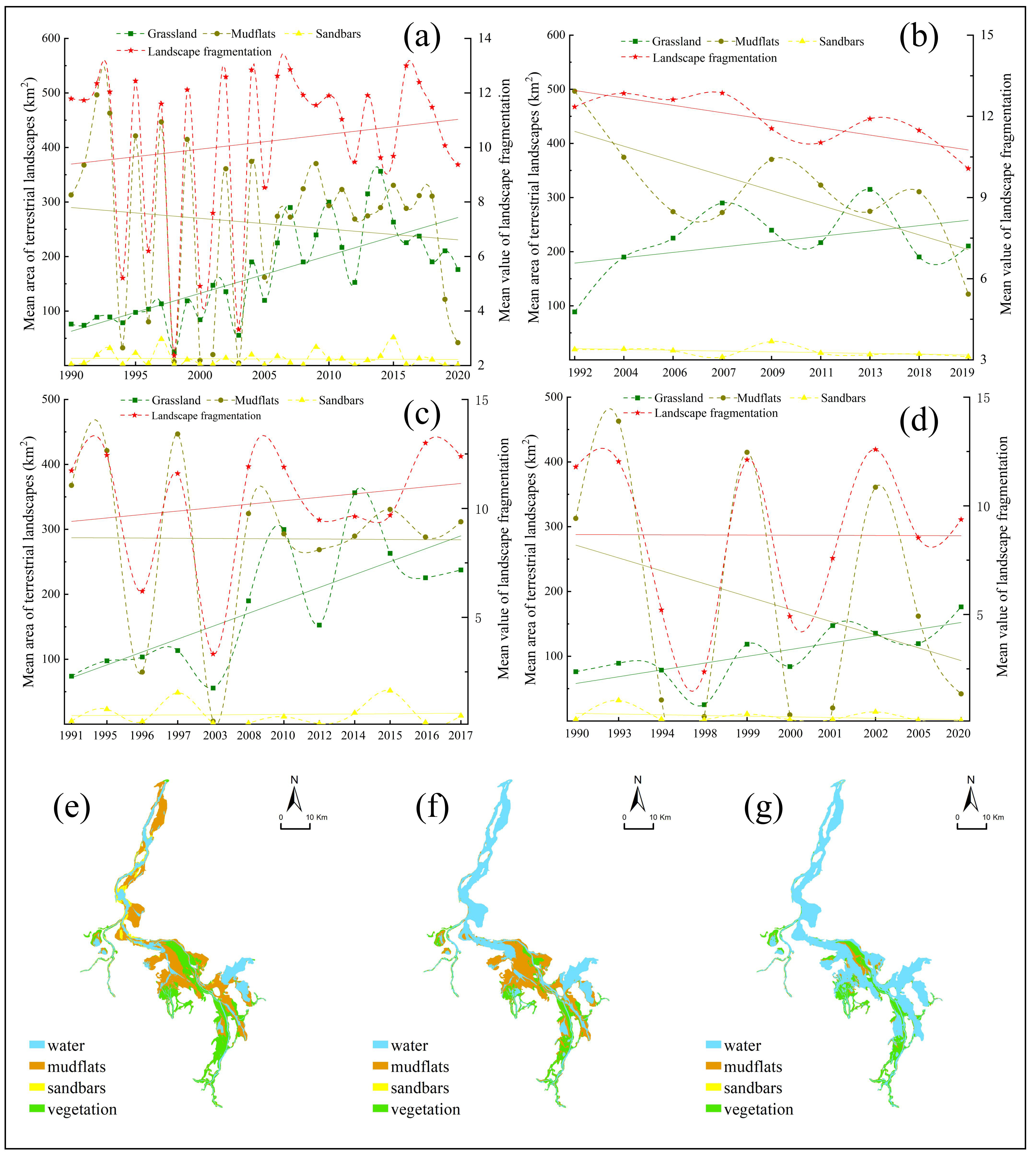
3.1. Landscape Variation within Habitats

From 1990 to 2020, the mean area of terrestrial landscapes within the porpoise habitat was 439.83 ± 194.31 km2, accounting for 49.53 ± 21.88% of the habitat area. Grassland and mudflats were the two major landscape types observed, with a mean area of 260.26 ± 148.70 km2 (accounting for 52.39 ± 21.96% of the total area) and 167.29 ± 85.03 km2 (45.04 ± 22.33% of the total area). The mean value of landscape fragmentation within the habitat was 10.21 ± 2.96. Grassland area and landscape fragmentation increased over the past 30 years (Figure 3).
During dry condition years, the mean area of terrestrial landscapes was 572.51 ± 194.31 km2, accounting for 64.47 ± 5.10% of the habitat area. Mudflat areas were the dominant landscape type, with a mean area of 336.93 ± 76.43 km2 (58.71 ± 11.31% of the total). The mean value of landscape fragmentation within the habitat was 11.86 ± 0.93. The area of mudflats and landscape fragmentation decreased over the past 30 years (Figure 3).
During normal conditions, terrestrial landscapes occupied 54.20 ± 20.67% of the habitat area, with a mean area of 481.36 ± 183.53 km2. The percentage of the mudflats was 55.40 ± 19.86%. The mean value of landscape fragmentation within the habitat was 10.27 ± 2.89, showing an increase over the past 30 years (Figure 3).
Under flood conditions, the mean area of terrestrial landscapes was 294.55 ± 201.03 km2, accounting for 33.17 ± 22.64% of the habitat area. Grassland was the major landscape type, accounting for 52.39 ± 30.10% of the total area. The mean value of landscape fragmentation within the habitat was 8.65 ± 3.58, and it remained stable in the flood years (Figure 3).

3.2. Characteristics of Hydrological Conditions in the Habitat

Under dry conditions, the mean water depth within the habitat was 1.77 ± 2.94 m. The water depth was mainly less than 3 m, except for the main waterway (Figure 4). During September, about 59% of the habitat area experienced a rapid water depth decline, dropping to less than 1 m within 15 days. The overall water depth difference of the habitat was 3.47 ± 1.74 m, and the water depth difference in the northern habitat is higher than that in the south (Figure 4).
Under normal conditions, the mean water depth within the habitat increased to 4.63 ± 3.44 m. The water depth in the northern habitats all exceeded 3 m (Figure 4). Over 45% of the habitat water depth decreased below 1 m in ~45 days since September, almost all of which were distributed in the southern part of the habitat (Figure 4). The water depth difference in habitat all exceeded 5 m (Figure 4), with a mean value of 8.60 ± 1.84 m.
Under flood conditions, the spatial characteristics of water depth were similar to normal conditions, averaging 4.89 ± 3.40 m. From September, it took 75 days for more than half of the habitat water depth to drop below 1 m (Figure 4). The water depth difference in all habitats exceeded 8 m (Figure 4), with a mean value of 11.81 ± 1.83 m.

3.3. Stranding Risk of the Yangtze Finless Porpoise

In all scenarios, high stranding risk areas were only located within boundaries of the eight cities where porpoise stranding cases have been recorded (Figure 1d). Under dry conditions, the area of high stranding risk was 284.54 km2, accounting for 32% of the habitat range. High-risk areas were distributed continuously in the northern, central, and southern habitats of the lake (Figure 5). The high-risk areas within the boundaries of Duchang, Yugan, Xinjian, Yongxiu, and Hukou all exceeded 10% of the total high-risk areas (Table 3). Under normal conditions, high-risk areas were discontinuously distributed in most habitat areas, with a total area of 251.04 km2. High-risk areas distributed in the central areas of Poyang Lake (within the boundaries of Duchang and Xinjian) accounted for almost half of the total area (Table 3). Under flood conditions, high-risk areas were smaller (90.12 km2), and were unevenly distributed in the habitat. Again, Duchang contained most of the high-risk areas, accounting for 32.24% of the total (Table 3).

3.4. Characteristics of High Stranding Risk Areas

The mean bathymetry of the high-risk areas was similar in all scenarios, with an average of 7.81 ± 3.36 m. The mean bathymetry relief degree in the high-risk area had a gradient pattern, with the highest degree under dry conditions (6.1 ± 4.45 m) and the lowest under flood conditions (5.54 ± 4.26 m). The mean water depth of high-risk areas during September to February was 1.75 ± 2.72 m under dry conditions, which was significantly lower than under normal conditions (5.54 ± 4.26 m) and flood conditions (5.54 ± 4.26 m, Figure 6). Under dry and normal conditions, mudflat area was the major terrestrial landscape within the high-risk area, with a mean proportion of 46% and 41% of the total high-risk area, respectively (Figure 6).

4. Discussion

Stranding records are a critical information source for understanding cetaceans [5]. However, existing stranding records and studies of freshwater cetaceans are far less detailed than those of marine cetaceans [33,34,35]. In marine systems, changes in natural conditions such as geomagnetic storms, storms, sea surface temperature change, and physical contact with ships often lead to disorientation, injury, death, and subsequent stranding [36,37]. In contrast, stranding of freshwater cetaceans inhabiting seasonal river basins is often the direct cause of their high mortality, including the Indus River dolphin, the Ganges River Dolphin, and the Yangtze finless porpoise [9,38,39]. These freshwater cetaceans tend to have specific preferences for hydrological conditions [11], and a significant drop in water depth within their habitats can lead to them being trapped in isolated waters, leading to stranding [40]. Therefore, finding links between population decline and natural environmental conditions is of great significance for formulating macro-conservation strategies. Due to the lack of information on the proximal causes of the death of freshwater cetaceans, the establishment of a sound stranding information network is critical [8]. Here, we have provided a novel approach that combines remote sensing and hydrodynamic modeling to map the high stranding risk area of the Yangtze finless porpoise in a typical seasonal lake, which is a key step in collecting stranding data and developing targeted conservation strategies.

4.1. Evaluation Indicator Selection

We selected four environmental conditions as the evaluation indicators of the Yangtze finless porpoise stranding risk based on the characteristics of Poyang Lake. The first one is landscape fragmentation, which represents the distribution pattern of water and land. Generally, the water level of Poyang Lake begins to decline in September, and large areas of grassland, mudflats, and sandbars are exposed during November to December [25]. Therefore, the general situation and trends of the water and land distribution in the lake can be understood through the extraction of landscape types over time. High landscape fragmentation indicates that the waters in the area are separated into independent units by land, which will inevitably increase the risk of porpoise stranding. The second indicator is days of water depth decline. When the water depth is less than 1 m, freshwater cetaceans are likely to be trapped because there is not enough space for them to swim and escape [8,26]. We thus determined the number of days it took for the water depth in the habitat to drop below 1 m under dry, normal, and flood scenarios. From the beginning of September to the end of February, the shorter the number of days, the faster water depth recedes, and the higher the risk of porpoises being trapped. The third indicator is the water depth difference, which is the difference between the maximum water depth and the minimum water depth from September to February. Our previous work demonstrated that the water depth preference of the Yangtze finless porpoises varies from 4 to 12 m with the season [11], and the larger the water depth difference, the higher the instability of the area. The fourth indicator is the relief degree of lake bathymetry, which is often used in the suitability evaluation of terrestrial ecological environments [30,32]. In aquatic ecosystems, the relief degree represents the difference in the bathymetry within a unit area [41]. The higher the relief degree, the easier it is to form isolated ponds when the water depth drops, causing the porpoise to be tapped and stranded.

4.2. The Plight of the Yangtze Finless Porpoise

Poyang Lake is often considered the last refuge of the Yangtze finless porpoise [13], though the population growth rate of the porpoise is declining [16]. From 2008 to 2014, the number of dead porpoises found in Poyang Lake was nearly 30% of the total found in the Yangtze River basin. We found here that the high stranding risk area accounted for a high proportion of the porpoise habitat, especially during dry years. At the end of the wet season, porpoise habitats become greatly compressed until only habitats in the narrow main waterway remain [42]. Since 2000, both natural and anthropogenic factors have complicated the protection and the population recovery efforts of Yangtze finless porpoises in Poyang Lake. First, the continuous water decline of the lake has caused an advanced and prolonged dry season, and a decrease in inundation area [17,43,44]. Compared with the previous period, the water level within the Duchang boundary with the most high-risk areas obtained in this study decreased by more than 0.8 m after 2000 [45]. This is also the area where the most dead porpoises have been found (unpublished data from the Department of agriculture and Rural Affairs of Jiangxi Province). The drop in water level will cause more terrestrial landscapes to be exposed during the dry season. The grassland of the lake has expanded toward the center of the lake in recent years [25]. At the same time, grassland in the lake is a natural spawning ground and feeding ground for fish fauna, and the porpoises prefer waters closer to grassland [24].
Poyang Lake has now banned fishing for ten years, so overfishing should not significantly contribute to the stranding of the porpoises in the near future [19]. The current major human disturbance in the lake that may exacerbate the risk of porpoise stranding is high magnitude sand mining. Poyang Lake has supplied a large amount of sand and gravel for infrastructure development in China since 2000, and it currently has one of the largest sand mining fields in the world [46]. Sand mining operations in Poyang Lake are mainly concentrated in the northern waterway connecting with the Yangtze River. This area is an important habitat for Yangtze finless porpoises, and there are also large areas of high stranding risk area (Figure 5, Table 3). Sand mining operations will create undulating dunes and pits on the lake bottom, which may attract porpoises to feed and become stranded [13,28]. In general, the environmental conditions of the habitats of Yangtze finless porpoises are degrading, and there is a possibility of increasing high-stranding risk areas. Targeted measures are thus urgently needed to alleviate this situation.

4.3. Suggested Implementation Measures

Stranding rates are also high for freshwater cetaceans inhabiting the Indus and Ganges River basins, due to extensive barrage and canal networks that cause them to enter irrigation canals during dry seasons for suitable water depth conditions [40]. Most of these river dolphins have been rescued under commendable rescue–release operations [47]. However, for a large shallow lake with a maximum area in excess of 4000 km2 [48], the high stranding area is widely distributed, and varies with shifting hydrological conditions (Figure 5). Thus, detecting trapped or stranded Yangtze finless porpoise in Poyang Lake is more complicated than Indus/Ganges River dolphins found in irrigation canals. In addition, most of the high-stranding risk areas in Poyang Lake cannot be reached by boats due to the low water depth, which means it is technically challenging to detect and rescue the stranded porpoise in time. Given this, we recommended the following measures:
  • The high-risk areas identified in this study require systematic and targeted investigations of the Yangtze finless porpoise, especially in years with low water level and rapid water decline.
  • Governments of cities containing high-risk areas should strengthen training and logistical support for porpoise rescue and formulate sound rescue guidelines by learning from the successful experience of other wildlife conservation efforts.
  • A wider social awareness of porpoise stranding protection requires widespread participation, including research institutes, universities, and NGOs. Because of the recent fishing ban, former fishers are ideal partners to provide critical support in the planning of surveys and rescue routes.
  • It is necessary to explore the feasibility of technical interventions to help the porpoises escape from high stranding risk areas. Methods such as acoustic facilities, artificial landscape modifications, and water level regulation can all help prevent porpoise stranding, while other impacts they will cause cannot be underestimated.

4.4. Implications for Future Conservation

For the conservation of endangered long-lived mammals, mortality determines population variation. Therefore, obtaining the correlation between the actual cause of death and mortality can guide conservation strategies. Freshwater cetaceans urgently need stranding networks like marine cetaceans [5,9]. Our study presents baseline information on identifying the Yangtze finless porpoise stranding risk, which is a first step in establishing a stranding network. By conducting intensive surveys in high-risk areas, the location and environmental conditions of the porpoise mortalities can be systematically collected, and further biological information can be obtained through necropsy techniques.
A sound stranding network should also include long-term monitoring of key environmental elements, such as changes in hydrological conditions and wetland landscapes within Poyang Lake, in order to respond to possible mortality peaks rapidly. With the development of hyperspectral remote sensing, the temporal and spatial resolution of freshwater ecosystems monitoring has greatly improved [49,50]. Hydrodynamic models can reproduce hydrological situations under natural conditions and realize simulations under artificial control [11,28]. These two techniques, combined with detailed mortality information, can serve to formulate future conservation strategies to reduce the extinction risk of endangered freshwater cetaceans.

5. Conclusions

The stranding risk of porpoises in Poyang Lake is high, due to seasonal changes in hydrological regime and wetland landscapes distribution. Using average water level from September to February, we classified the years from 1990 to 2020 as typical scenarios of flood, normal, and dry conditions. The distribution of landscape types and landscape fragmentation in the porpoise habitat range from 1990 to 2020 were then extracted through remote sensing. The daily water depth from September to February under each scenario was simulated by hydrodynamic modeling. A stranding risk assessment model was constructed according to four indicators: landscape fragmentation, days of water depth decline, water depth difference, and relief degree of lake bathymetry.
Our results demonstrate the following. First, half of the porpoise habitat will be exposed during the dry season, forming grassland and mudflats, and this landscape fragmentation is increasing; Second, from September to February, the water depth of nearly half of the habitat declined to less than 1 m within 15 days (dry scenario), 45 days (normal), and 75 days (flood). The mean water depth difference of the habitat varied from 3.47 to 11.81 m in the three scenarios. Third, the high-risk range was 284 km2, 251 km2, 90 km2 in the dry, flat, and abundant scenarios, accounting for 32%, 29%, and 10% of the total habitat area, respectively. Fourth, the high stranding risk area has an average bathymetry of 7.81 m and mean bathymetry relief degree of 5.87 m. We strongly suggest that high-risk areas within the boundaries of cities around Poyang Lake should conduct systematic surveys in the future and record detailed data on stranding cases. The methods of our study can support the establishment of sound stranding networks by understanding and quantifying the relationship between changes in environmental conditions.

Author Contributions

Conceptualization, Q.L. and G.L.; methodology, G.L. and Y.L.; validation, Q.L. and W.L.; formal analysis, Q.L., W.L. and W.W.; investigation, W.L., and W.W.; resources, Q.L.; data curation, Q.L.; writing—original draft preparation, Q.L.; writing—review and editing, A.T.D.; visualization, Q.L. and W.L.; supervision, G.L. and S.Z.; funding acquisition, G.L. and Q.L. All authors have read and agreed to the published version of the manuscript.

Funding

This research was funded by National Natural Science Foundation of China (Grant number: 42161014, funding to Geying Lai).

Data Availability Statement

The data presented in this study are available on request from the first author.

Conflicts of Interest

The authors declare no conflict of interest.

References

  1. Gomez-Salazar, C.; Coll, M.; Whitehead, H. River dolphins as indicators of ecosystem degradation in large tropical rivers. Ecol. Indic. 2012, 23, 19–26. [Google Scholar] [CrossRef] [Green Version]
  2. Hunt, T.N.; Allen, S.J.; Bejder, L.; Parra, G.J. Identifying priority habitat for conservation and management of Australian humpback dolphins within a marine protected area. Sci. Rep. 2020, 10, 14366. [Google Scholar] [CrossRef] [PubMed]
  3. Huang, S.L.; Wang, X.; Wu, H.; Peng, C.; Jefferson, T.A. Habitat protection planning for Indo-Pacific humpback dolphins (Sousa chinensis) in deteriorating environments: Knowledge gaps and recommendations for action. Aquat. Conserv. Mar. Freshw. Ecosyst. 2021, 32, 171–185. [Google Scholar] [CrossRef]
  4. Barragán-Barrera, D.C.; Do Amaral, K.B.; Chávez-Carreño, P.A.; Farías-Curtidor, N.; Lancheros-Neva, R.; Botero-Acosta, N.; Bueno, P.; Moreno, I.B.; Bolaños-Jiménez, J.; Bouveret, L.; et al. Ecological Niche Modeling of Three Species of Stenella Dolphins in the Caribbean Basin, with Application to the Seaflower Biosphere Reserve. Front. Mar. Sci. 2019, 6, 10. [Google Scholar] [CrossRef] [Green Version]
  5. Coombs, E.J.; Deaville, R.; Sabin, R.C.; Allan, L.; O’Connell, M.; Berrow, S.; Smith, B.; Brownlow, A.; Doeschate, M.T.; Penrose, R.; et al. What can cetacean stranding records tell us? A study of UK and Irish cetacean diversity over the past 100 years. Mar. Mammal Sci. 2019, 35, 1527–1555. [Google Scholar] [CrossRef]
  6. Obusan, M.C.M.; Rivera, W.L.; Siringan, M.A.T.; Aragones, L.V. Stranding events in the Philippines provide evidence for impacts of human interactions on cetaceans. Ocean Coast. Manag. 2016, 134, 41–51. [Google Scholar] [CrossRef]
  7. Huang, S.; Hao, Y.; Mei, Z.; Turvey, S.T.; Wang, D. Common pattern of population decline for freshwater cetacean species in deteriorating habitats. Freshw. Biol. 2012, 57, 1266–1276. [Google Scholar] [CrossRef]
  8. Braulik, G.T.; Reichert, A.P.; Ehsan, T.; Khan, S.; Northridge, S.P.; Alexander, J.S.; Garstang, R. Habitat use by a freshwater dolphin in the low-water season. Aquat. Conserv. Mar. Freshw. Ecosyst. 2012, 22, 533–546. [Google Scholar] [CrossRef]
  9. Braulik, G.T.; Noureen, U.; Arshad, M.; Reeves, R.R. Review of status, threats, and conservation management options for the endangered Indus River blind dolphin. Biol. Conserv. 2015, 192, 30–41. [Google Scholar] [CrossRef]
  10. Braulik, G.T.; Arshad, M.; Noureen, U.; Northridge, S.P. Habitat fragmentation and species extirpation in freshwater ecosystems; causes of range decline of the Indus river dolphin (Platanista gangetica minor). PLoS ONE 2014, 9, e101657. [Google Scholar] [CrossRef]
  11. Li, Q.; Lai, G.; Liu, Y.; Devlin, A.T.; Zhan, S.; Wang, S. Identifying the seasonal characteristics of likely habitats for the Yangtze finless porpoise in Poyang Lake. Aquat. Conserv. Mar. Freshw. Ecosyst. 2022, 32, 523–536. [Google Scholar] [CrossRef]
  12. Turvey, S.T.; Pitman, R.L.; Taylor, B.L.; Barlow, J.; Akamatsu, T.; Barrett, L.A.; Zhao, X.; Reeves, R.R.; Stewart, B.S.; Wang, K.; et al. First human-caused extinction of a cetacean species? Biol. Lett. 2007, 3, 537–540. [Google Scholar] [CrossRef] [PubMed] [Green Version]
  13. Huang, J.; Mei, Z.; Chen, M.; Han, Y.; Zhang, X.; Moore, J.E.; Zhao, X.; Hao, Y.; Wang, K.; Wang, D. Population survey showing hope for population recovery of the critically endangered Yangtze finless porpoise. Biol. Conserv. 2020, 241, 108315. [Google Scholar] [CrossRef]
  14. Chen, T.; Wang, Y.; Gardner, C.; Wu, F. Threats and protection policies of the aquatic biodiversity in the Yangtze River. J. Nat. Conserv. 2020, 58, 125931. [Google Scholar] [CrossRef]
  15. Mei, Z.; Zhang, X.; Huang, S.; Zhao, X.; Hao, Y.; Zhang, L.; Qian, Z.; Zheng, J.; Wang, K.; Wang, D. The Yangtze finless porpoise: On an accelerating path to extinction? Biol. Conserv. 2014, 172, 117–123. [Google Scholar] [CrossRef]
  16. Liu, X.; Mei, Z.; Zhang, J.; Sun, J.; Zhang, N.; Guo, Y.; Wang, K.; Hao, Y.; Wang, D. Seasonal Yangtze finless porpoise (Neophocaena asiaeorientalis asiaeorientalis) movements in the Poyang Lake, China: Implications on flexible management for aquatic animals in fluctuating freshwater ecosystems. Sci. Total Environ. 2022, 807, 150782. [Google Scholar] [CrossRef] [PubMed]
  17. Li, Q.; Lai, G.; Devlin, A.T. A review on the driving forces of water decline and its impacts on the environment in Poyang Lake, China. J. Water Clim. Chang. 2021, 12, 1370–1391. [Google Scholar] [CrossRef]
  18. Xu, Z. The Study of the Yangtze Finless Porpoise Population Status and Behavior Characteristics and Protection in the Key Waters of Poyang Lak. Master’s Thesis, Nanchang University, Nanchang, China, 2015; p. 62. (In Chinese). [Google Scholar]
  19. Zhang, H.; Kang, M.; Shen, L.; Wu, J.; Li, J.; Du, H.; Wang, C.; Yang, H.; Zhou, Q.; Liu, Z.; et al. Rapid change in Yangtze fisheries and its implications for global freshwater ecosystem management. Fish Fish. 2020, 21, 601–620. [Google Scholar] [CrossRef]
  20. Xu, N. Detecting Coastline Change with All Available Landsat Data over 1986–2015: A Case Study for the State of Texas, USA. Atmosphere 2018, 9, 107. [Google Scholar] [CrossRef] [Green Version]
  21. Specht, M.; Specht, C.; Lewicka, O.; Makar, A.; Burdziakowski, P.; Dąbrowski, P. Study on the Coastline Evolution in Sopot (2008–2018) Based on Landsat Satellite Imagery. J. Mar. Sci. Eng. 2020, 8, 464. [Google Scholar] [CrossRef]
  22. Wang, X.; Liu, Y.; Ling, F.; Liu, Y.; Fang, F. Spatio-Temporal Change Detection of Ningbo Coastline Using Landsat Time-Series Images during 1976–2015. ISPRS Int. J. Geo-Inf. 2017, 6, 68. [Google Scholar] [CrossRef] [Green Version]
  23. Maglione, P.; Parente, C.; Vallario, A. Coastline extraction using high resolution WorldView-2 satellite imagery. Eur. J. Remote Sens. 2014, 47, 685–699. [Google Scholar] [CrossRef]
  24. Li, Q.; Dai, X.; Liu, Y.; Devlin, A.T.; Lai, G.; Wang, W. Potential spawning grounds of phytophilic fish under a shifting hydrological regime in Poyang Lake, China. Fish. Manag. Ecol. 2022. [Google Scholar] [CrossRef]
  25. Han, X.; Chen, X.; Feng, L. Four decades of winter wetland changes in Poyang Lake based on Landsat observations between 1973 and 2013. Remote Sens. Environ. 2015, 156, 426–437. [Google Scholar] [CrossRef]
  26. Smith, B.D. 1990 Status and conservation of the Ganges River dolphin Platanista gangetica in the Karnali River, Nepal. Biol. Conserv. 1993, 66, 159–169. [Google Scholar] [CrossRef]
  27. Lai, G.; Wang, P.; Li, L. Possible impacts of the Poyang Lake (China) hydraulic project on lake hydrology and hydrodynamics. Hydrol. Res. 2016, 47, 187–205. [Google Scholar] [CrossRef] [Green Version]
  28. Li, Q.; Lai, G.; Liu, Y.; Thomas Devlin, A.; Zhan, S.; Wang, S. Assessing the impact of the proposed Poyang lake hydraulic project on the Yangtze finless porpoise and its calves. Ecol. Indic. 2021, 129, 107873. [Google Scholar] [CrossRef]
  29. Zou, L.; Hu, B.; Qi, S.; Zhang, Q.; Ning, P. Spatiotemporal Variation of Siberian Crane Habitats and the Response to Water Level in Poyang Lake Wetland, China. Remote Sens. 2021, 13, 140. [Google Scholar] [CrossRef]
  30. Ferreira, I.J.M.; Ferreira, J.H.D.; Bueno, P.A.A.; Vieira, L.M.; Bueno, R.D.O.; Couto, E.V.D. Spatial dimension landscape metrics of Atlantic Forest remnants in Paraná State, Brazil. Acta Scientiarum. Technol. 2018, 40, 36503. [Google Scholar] [CrossRef]
  31. Wang, R.; Zhang, S.; Wang, R.; Pu, L.; Li, F.; Wang, Q.; Chen, D.; Yang, J.; Chang, L.; Bu, K. Analysis on the relief amplitude in Northeast China based on ASTER GDEM and mean change point method. Arid. Land Resour. Environ. 2016, 30, 49–54. (In Chinese) [Google Scholar]
  32. Xiao, C.; Li, P.; Feng, Z. Re-delineating mountainous areas with three topographic parameters in Mainland Southeast Asia using ASTER global digital elevation model data. J. Mt. Sci. 2018, 15, 1728–1740. [Google Scholar] [CrossRef]
  33. Boon, P.J.; Baxter, J.M. Editorial: Putting the conservation into Aquatic Conservation. Aquat. Conserv. Mar. Freshw. Ecosyst. 2021, 31, 1927–1928. [Google Scholar] [CrossRef]
  34. Hartman, K.L.; Fernandez, M.; Azevedo, J.M.N. Spatial segregation of calving and nursing Risso’s dolphins (Grampus griseus) in the Azores, and its conservation implications. Mar. Biol. 2014, 161, 1419–1428. [Google Scholar] [CrossRef]
  35. Hartel, E.F.; Noke Durden, W.; Corry-Crowe, G.O. Testing satellite telemetry within narrow ecosystems: Nocturnal movements and habitat use of bottlenose dolphins within a convoluted estuarine system. Anim. Biotelemetry 2020, 8, 13. [Google Scholar] [CrossRef]
  36. Truchon, M.H.; Measures, L.; L’Herault, V.; Brethes, J.C.; Galbraith, P.S.; Harvey, M.; Lessard, S.; Starr, M.; Lecomte, N. Marine mammal strandings and environmental changes: A 15-year study in the St. Lawrence ecosystem. PLoS ONE 2013, 8, e59311. [Google Scholar] [CrossRef] [Green Version]
  37. Prado, J.H.F.; Mattos, P.H.; Silva, K.G.; Secchi, E.R. Long-Term Seasonal and Interannual Patterns of Marine Mammal Strandings in Subtropical Western South Atlantic. PLoS ONE 2016, 11, e146339. [Google Scholar] [CrossRef] [Green Version]
  38. Smith, B.D.; Braulik, G.; Strindberg, S.; Mansur, R.; Diyan, M.A.A.; Ahmed, B. Habitat selection of freshwater-dependent cetaceans and the potential effects of declining freshwater flows and sea-level rise in waterways of the Sundarbans mangrove forest, Bangladesh. Aquat. Conserv. Mar. Freshw. Ecosyst. 2009, 19, 209–225. [Google Scholar] [CrossRef]
  39. Mei, Z.; Huang, S.; Hao, Y.; Turvey, S.T.; Gong, W.; Wang, D. Accelerating population decline of Yangtze finless porpoise (Neophocaena asiaeorientalis asiaeorientalis). Biol. Conserv. 2012, 153, 192–200. [Google Scholar] [CrossRef]
  40. Prajapati, S. Stranding cases of endangered Ganges river dolphins in the Ghaghara-Sharada irrigation canals, Ganges river basin, India: Conservation implications. Mammalia 2021, 85, 39–46. [Google Scholar] [CrossRef]
  41. Costello, M.J.; Cheung, A.; De Hauwere, N. Surface Area and the Seabed Area, Volume, Depth, Slope, and Topographic Variation for the World’s Seas, Oceans, and Countries. Environ. Sci. Technol. 2010, 44, 8821–8828. [Google Scholar] [CrossRef]
  42. Dong, L.; Wang, D.; Wang, K.; Li, S.; Mei, Z.; Wang, S.; Akamatsu, T.; Kimura, S. Yangtze finless porpoises along the main channel of Poyang Lake, China: Implications for conservation. Mar. Mammal Sci. 2015, 31, 612–628. [Google Scholar] [CrossRef]
  43. Liu, Y.; Wu, G.; Zhao, X. Recent declines in China’s largest freshwater lake: Trend or regime shift? Environ. Res. Lett. 2013, 8, 14010. [Google Scholar] [CrossRef]
  44. Feng, L.; Hu, C.; Chen, X.; Cai, X.; Tian, L.; Gan, W. Assessment of inundation changes of Poyang Lake using MODIS observations between 2000 and 2010. Remote Sens. Environ. 2012, 121, 80–92. [Google Scholar] [CrossRef]
  45. Ye, X.; Xu, C.; Zhang, Q.; Yao, J.; Li, X. Quantifying the Human Induced Water Level Decline of China’s Largest Freshwater Lake from the Changing Underlying Surface in the Lake Region. Water Resour. Manag. 2018, 32, 1467–1482. [Google Scholar] [CrossRef]
  46. De Leeuw, J.; Shankman, D.; Wu, G.; de Boer, W.F.; Burnham, J.; He, Q.; Yesou, H.; Xiao, J. Strategic assessment of the magnitude and impacts of sand mining in Poyang Lake, China. Reg. Environ. Chang. 2010, 10, 95–102. [Google Scholar] [CrossRef]
  47. Waqas, U.; Malik, M.; Khokhar, L. Conservation of Indus River Dolphin (Platanista gangetica minor) in the Indus River System, Pakistan: An overview. Rec. Zool. Surv. Pak. 2012, 21, 82–85. [Google Scholar]
  48. Dronova, I.; Gong, P.; Wang, L. Object-based analysis and change detection of major wetland cover types and their classification uncertainty during the low water period at Poyang Lake, China. Remote Sens. Environ. 2011, 115, 3220–3236. [Google Scholar] [CrossRef]
  49. Tian, H.; Li, W.; Wu, M.; Huang, N.; Li, G.; Li, X.; Niu, Z. Dynamic Monitoring of the Largest Freshwater Lake in China Using a New Water Index Derived from High Spatiotemporal Resolution Sentinel-1A Data. Remote Sens. 2017, 9, 521. [Google Scholar] [CrossRef] [Green Version]
  50. Zhang, P.; Lu, J.; Feng, L.; Chen, X.; Zhang, L.; Xiao, X.; Liu, H. Hydrodynamic and Inundation Modeling of China’s Largest Freshwater Lake Aided by Remote Sensing Data. Remote Sens. 2015, 7, 4858–4879. [Google Scholar] [CrossRef] [Green Version]
Figure 1. (a) The location of the Yangtze River Basin and the Poyang Lake; (b) Map of the Poyang Lake basin, including the Poyang Lake and tributaries; (c) Map of the lake boundary, grid, inflow boundary, and outflow boundary used in hydrodynamic modeling, and the location of Xingzi hydrological station; (d) Maps of the boundary of the cities which lie on Poyang Lake. The cities employed here are: Hukou (HK), Jiujiang (JJ), Xingzi (XZ), Gongqing (GQ), Yongxiu (YX), Duchang (DC), Poyang (PY), Xinjian (XJ), Nanchang (NC), Yugan (YG), and Jinxian (JX). Note that only the cities marked in red have recorded porpoise stranding cases.
Remotesensing 14 02455 g001
Figure 2. Maps of wetland landscape differences between wet and dry seasons within the Yangtze finless porpoise habitat; (a) Map of the flood season; (b) Map of the dry season; (1–6) Enlargement of areas labelled in (a,b).
Remotesensing 14 02455 g002
Figure 3. (ad) The variation of landscape areas and the landscape fragmentation in habitats from 1990 to 2020, (a) variation in all years, (b) dry years, (c) normal years, (d) flood years; (eg) wetland landscapes within the habitat range, (e) dry condition in 2019, (f) normal condition in 2012, (g) flood condition in 2020.
Remotesensing 14 02455 g003
Figure 4. (ac) Mean water depth during September to February under flood, normal, and dry conditions, respectively; (df) Days of water depth decline below 1 m under flood, normal, and dry conditions, respectively; (gi) Water depth difference under flood, normal, and dry conditions, respectively; (j) Bathymetry of habitat; (k) Relief degree of bathymetry.
Remotesensing 14 02455 g004
Figure 5. (ac) The stranding risk of the Yangtze finless porpoise habitats under flood, normal, and dry conditions, respectively; (df) Distribution of high stranding risk areas under dry, normal, and flood conditions, respectively.
Remotesensing 14 02455 g005
Figure 6. Configuration characteristics of high stranding risk areas in dry, normal, and flood scenarios; (a) Conditions of bathymetry, relief degree, and mean water depth; (b) Areas of different landscapes.
Remotesensing 14 02455 g006
Table 1. Mean water level of Xingzi station from September to October. Each year from 1990–2020 was divided into three scenarios: Dry condition, normal condition, and flood condition.
Dry ConditionNormal ConditionFlood Condition
YearMean Water Level (m)YearMean Water Level (m)YearMean Water Level (m)
19928.4919919.95199010.09
20048.6519959.91199310.91
20067.2719969.66199410.16
20078.3219979.62199811.81
20096.5320039.65199910.5
20117.6620089.59200010.84
20137.9620109.39200110.05
20188.4920129.57200210.21
20197.9220149.18200510.2
20159.35202010.51
20169.09
20179.28
Average7.92Average9.52Average10.53
Table 2. Validation results of water level simulated by the EFDC hydrodynamic model and recorded at Xingzi hydrological station; R represents recorded water level; S represents simulated water level.
Mean Water Level in 2019 (m)Mean Water Level in 2012 (m)Mean Water Level in 2020 (m)
RSMAEMRERMSERSMAEMRERMSERSMAEMRERMSE
10.8811.070.222.150.2811.9512.330.383.870.4611.9712.190.242.470.33
Table 3. High porpoise stranding risk areas (within city boundaries) under dry, normal, and flood scenarios. The cities employed here are: Duchang (DC), Hukou (HK), Jiujiang (JJ), Poyang (PY), Xinjian (XJ), Xingzi (XZ), Yongxiu (YX), and Yugan (YG).
Dry ConditionsNormal ConditionsFlood Conditions
CityHigh Risk Area (km2)Proportion (%)High Risk Area (km2)Proportion
(%)
High Risk Area (km2)Proportion
(%)
DC92.7432.5970.9928.2829.0632.24
HK29.8210.4823.899.524.845.37
JJ8.923.1410.204.063.323.68
PY17.276.0712.625.035.416.00
XJ39.9114.0350.6820.1920.0122.21
XZ15.295.3718.807.498.719.66
YX36.0912.6829.4511.7310.6311.79
YG44.4915.6434.4213.718.169.05
Total284.54100251.0410090.1232.24
Publisher’s Note: MDPI stays neutral with regard to jurisdictional claims in published maps and institutional affiliations.

